Resilience on the Great Lakes: A Tale of Two Counties
|
|
|
- Shannon Carter
- 5 years ago
- Views:
Transcription
1 Resilience on the Great Lakes: A Tale of Two Counties James C. Schwab, AICP Manager, APA Hazards Planning Research Center ASFPM No Adverse Impacts Seminar Milwaukee August 19, 2014
2 Why this approach? Comparisons can be instructive if well chosen Resilience is broad concept; which best practices are most important? Or is context more important? Opportunity to review broader range of issues potentially affecting coastal resilience Counties chosen: #1: Ozaukee County, Wisconsin #2: Berrien County, Michigan
3 What s different? Planning context: Wisconsin prescribes very specific set of elements to be included in comprehensive plans Authority: Wisconsin counties have land-use controls on unincorporated land, like most Midwest states Land-use authority in Michigan resides with townships and municipalities What they have in common: Shoreline on Lake Michigan Proximity to large urban centers
4 Whose system do you prefer? A. Michigan, with all land-use authority devolved to municipalities and townships, and counties playing only an advisory role in planning? B. Wisconsin, and most of the Midwest, with counties controlling zoning in unincorporated areas but cooperating with municipalities on extraterritorial zoning? 16% 84% A. B.
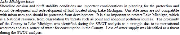
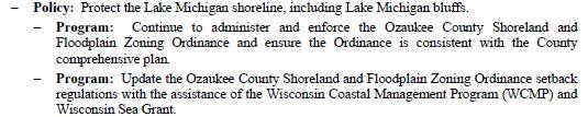
5 Ozaukee County First goal in Issues and Opportunities Element: Goal: Preserve and enhance Ozaukee County s natural resources, including Lake Michigan, open space, and agricultural land. Objective: Develop methods to protect and preserve agricultural areas. Objective: Develop methods to protect and preserve natural areas, including wetlands, wildlife habitats, lakes, woodlands, open spaces, groundwater resources, and floodplains. Objective: Preserve and enhance a system of parks and open spaces within the County. Objective: Encourage integrated water resource management of surface water, groundwater, and water dependent natural resources. Objective: Encourage the protection of Lake Michigan s water quality and shoreline, including Lake Michigan bluffs.

6 Protecting Environmental Corridors
7
8 Ozaukee: Natural Resources

9 National Weather Service map Natural Limitations to Building Site Development

10 Ozaukee: Land-use compatibility
11 Implementation Figures in Implementation Element list: 70 priority programs for Agriculture, Natural Resources, and Cultural Resources 27 priority programs for Land Use Very detailed plan (888 pages), but.... not always easy to sort out what might contribute specifically to resilience

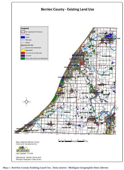
12 Berrien County, Michigan Much shorter plan at 56 pages because.... Not required to detail land-use practices; focuses strictly on policy in county s advisory capacity Rural land-use authority resides with townships (model shared with Pennsylvania and New Jersey)

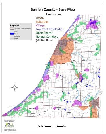
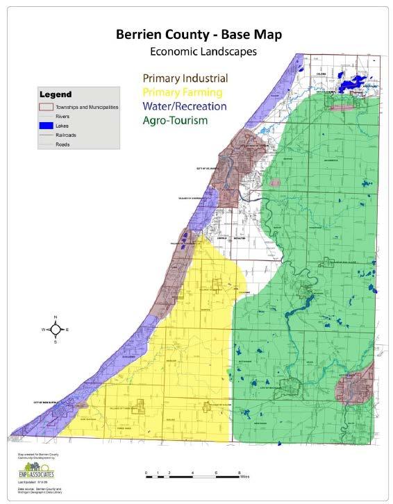
13 Landscapes Element Urban Small City/Village Suburban Lakefront/Residential Rural Open Space/Natural Areas Major Shoreline Communities in Berrien County: St. Joseph Benton Harbor


14 Berrien: Demographic shifts Population (projected) Growth exception: Grand Beach Village (up 51.4%)
15
16 Green Infrastructure Element Delineation of economic, health, and environmental benefits of green infrastructure Population projected to decrease, but interest from Chicagoland area will continue Little demand for housing, except for seasonal/second homes from Chicago suburbs.... However, the areas most attractive for these upscale residents often coincide with the most fragile natural areas. Vacation homes account for more than 10% of housing in seven communities
17 Should Berrien County coastal communities A. Be more aggressive in limiting lakefront residential development? B. Enact stricter setbacks without trying to limit the amount of such development? C. Encourage second-home owners to move back to Chicago, where they all came from? D. Increase minimum lot and building sizes to keep out all but the wealthy? 31% 58% 10% 2% A. B. C. D.
18 Green Infrastructure Principles (from SWMPC) Connectivity is key Context matters [GI] should be grounded in sound science and land-use planning theory and practice GI can and should function as the framework for conservation and development GI should be planned and protected before development GI is a critical public investment that should be funded up front GI affords benefits to nature and people GI respects the needs and desires of landowners and other stakeholders GI requires making connections to activities within and beyond the community GI requires long-term commitment

19 Green Infrastructure in Detroit After the flood: Expanded green infrastructure could help absorb rain, planners say Headline from MLive Michigan, August 16, 2014

20 Economic Development Rise of Agro-tourism: Proprietor jobs have risen in Berrien County
21
22 No Build: St. Joseph, MI Case study on Great Lakes Coastal Resilience site Ordinance driven by homeowner request for seawall that triggered concerns among neighbors (2012) Engineering firm hired to conduct study of impacts Moratorium imposed to allow completion of studies Setback recommended of above ordinary high tide line to protect public trust Ordinance created Edgewater Beach Overlay District (November 2012) north of St. Joseph River First such restrictions in Michigan along Lake Michigan
23 Does the St. Joseph ordinance A. Go too far in restricting the right to build? B. Not go far enough in protecting the lakefront? C. Split the difference just right and promote resilience in St. Joseph? 78% 18% 4% A. B. C.
")
24 No Build: St. Joseph, MI Subsequent FEMA Great Lakes Coastal Flood Study (2013) Berrien one of six counties included in data collection
25 Contact Information James C. Schwab, AICP Manager, APA Hazards Planning Research Center Co-Editor, Zoning Practice American Planning Association 205 N. Michigan Ave., Suite 1200 Chicago, IL phone: Web:
Berrien County Master Plan
 Introduction 2009 Berrien County Master Plan DRAFT for Board of Commissioners and Public Review 9/9/2009 Introduction Table of Contents Introduction... 1 Landscapes... 3 Green Infrastructure... 10 Economic
HAZARD MITIGATION GOALS AND OBJECTIVES
 SEWRPC Community Assistance Planning Report No. 282, 2nd Edition CITY OF MILWAUKEE ALL HAZARDS MITIGATION PLAN UPDATE Chapter IV HAZARD MITIGATION GOALS AND OBJECTIVES [NOTE: Throughout this plan update
Hazard Mitigation Planning. Association of New Jersey Environmental Commissions Workshop Edison, New Jersey October 20, 2012
 Hazard Mitigation Planning Association of New Jersey Environmental Commissions Workshop Edison, New Jersey October 20, 2012 Mitigation Planning NJ Hazard Mitigation Plan? What is the status of the HMP
Building Ecological Solutions to Coastal Community Hazards: Guidance and NJ Coastal Community Assistance
 Building Ecological Solutions to Coastal Community Hazards: Guidance and NJ Coastal Community Assistance Stacy Small-Lorenz National Wildlife Federation Restore America s Estuaries Summit New Orleans,
Oakland County s Green Infrastructure Vision. L. Brooks Patterson Oakland County Executive
 Oakland County s Green Infrastructure Vision L. Brooks Patterson Oakland County Executive Southeast Michigan 20 miles northwest of Detroit Consists of 910 square miles Population of 1.2 million More than
495/MetroWest Development Compact Plan Citizen Planner Training Collaborative Conference. March 17, 2012
 495/MetroWest Development Compact Plan Citizen Planner Training Collaborative Conference March 17, 2012 Project Process Local and Regional Priority Areas Growth Scenarios Transportation Investment Categories
CHAPTER 1: INTRODUCTION
 CHAPTER 1: INTRODUCTION MAP OF OUTAGAMIE COUNTY, WI N 1 = 6 miles INTRODUCTION The Town and Village of Black Creek are located in central Outagamie County, Wisconsin. The Village is located in the north
Chapter 10 IMPLEMENTATION RECOMMENDATIONS
 Chapter 10 IMPLEMENTATION RECOMMENDATIONS The recommended land use plan presented in the previous chapter provides a design for the attainment of the urban and rural development and open space preservation
Getting to Resilience webinar
 Getting to Resilience webinar A brief description of two NJDEP Projects: Resilient Coastal Communities Initiative & Municipal Public Access & Resiliency Small Grants Program June 26, 2014 Marty Rosen NJ
Whitemarsh Township Greenway Plan
 Whitemarsh Township Greenway Plan Prepared for: Whitemarsh Township August 16, 2007 Table of Contents Table of Contents... i Introduction... 1 Study Area Setting... 2 Regional Setting... 2 Township Character...
UPPER BRODHEAD CREEK PARADISE CREEK GREENWAY PLAN
 UPPER BRODHEAD CREEK PARADISE CREEK GREENWAY PLAN The Upper Brodhead & Paradise Creeks Greenway Cooperating Municipalities Mount Pocono Borough Paradise Township Barrett Township Price Township Funding
Municipal Plan*Assessment
 Municipal Plan*Assessment This tool was developed to assist in reviewing municipal master plans and in determining if these plans are consistent with smart growth principles, neighboring municipal plans,
Planning for Waterfront Communities
 Planning for Waterfront Communities Redevelopment Ready Communities Supplemental Training Program OFFICE OF THE GREAT LAKES Waterfront Community Best Practices and Guidelines New supplemental criteria
CMAP Resources for Green Infrastructure Planning
 CMAP Resources for Green Infrastructure Planning Resilient Chicago July 8, 2015 Kate Evasic Associate Planner Chicago Metropolitan Agency for Planning Formed by state law in 2005 to integrate planning
NORTH KINGSTOWN PILOT PROJECT May 9, 2016 North Kingstown Town Council
 Engaging RI Local Governments in Hazard Mitigation and Coastal Resilience NORTH KINGSTOWN PILOT PROJECT May 9, 2016 North Kingstown Town Council Teresa A. Crean, AICP University of Rhode Island Coastal
Innovative Land Use Techniques
 Innovative Land Use Techniques A Handbook for Sustainable Development Eric Williams, Assistant Administrator, NHDES Carolyn Russell, Principal Planner, NHDES Cliff Sinnott, Executive Director, RPC Jill
CHAPTER 4 FUTURE LAND USE AND URBAN SERVICES DISTRICTS
 CHAPTER 4 FUTURE LAND USE AND URBAN SERVICES DISTRICTS Introduction This chapter discusses how Benzie County should grow and change in the future. A community can grow and change in many different ways.
One County s Success in Linking Watershed Protection and Land Use Planning
 One County s Success in Linking Watershed Protection and Land Use Planning Bob Thompson Porter County Plan Commission March 28, 2012 Indiana Watershed Leadership Academy Population 160,000 Approximately
Linking Ecological Restoration and Economic Recovery at a Great Lakes Area of Concern: Muskegon Lake, MI. Heather Braun Great Lakes Commission
 Linking Ecological Restoration and Economic Recovery at a Great Lakes Area of Concern: Muskegon Lake, MI Heather Braun Great Lakes Commission Why Here? Restoration in urban centers: Muskegon Lake AOC Why
Town of Peru Comprehensive Plan Executive Summary
 Town of Peru Comprehensive Plan Executive Communities that plan grow by choice, not by chance. A plan makes growth thoughtful, understandable, and predictable. A plan shows that a community is managing
ITA and Vicinity Master Plan Update
 1 ITA and Vicinity Master Plan Update PHASE 3 SEPTEMBER 27, 2017 Three Phase Process 2 Phase 1 - Understanding October 13th Public Meeting Phase 2A - Exploring Ideas November 17th Public Meeting Phase
7Page 1 CLEMMONS COMMUNITY COMPASS 1 PLAN OVERVIEW
 1 Plan Overview WHAT IS I THE CLEMMONS COMMUNITY COMPASS? The Clemmons Community Compass is our community s comprehensive plan. It serves as our blueprint and provides direction for the future of the Village
Riparian Buffer on the Bushkill Creek. Policies
 Riparian Buffer on the Bushkill Creek Riparian buffers provide numerous benefits to landowners and the community by protecting groundwater recharge areas, providing flood control, providing stormwater
But What About the People? The Role of Urban Planning and Green Infrastructure
 But What About the People? The Role of Urban Planning and Green Infrastructure The Southeast Conservation Adaptation Strategy: A Model for Collaborative Conservation David Rouse, FAICP, ASLA Managing Director,
NJ Department of Environmental Protection
 NJ Department of Environmental Protection COASTAL AND LAND USE PLANNING New Jersey Coastal Management Program Covers NJ coastal waters to limit of tidal influence including 239 municipalities in 19 counties,
1 Introduction. Chapter. In this chapter:
 Chapter 1 Introduction In this chapter: 1.1 A Snapshot of the Region 1.2 Towards a Sustainable Region 1.3 The Provincial Context 1.4 Purpose and Organization The Regional Municipality of York Official
Shoreline Master Program Town of La Conner, Washington
 Shoreline Master Program Town of La Conner, Washington Department of Ecology approval effective Adopted September 24, 2013 by Town of La Conner Ordinance No.1106 Amended May 13, 2014 by Town of La Conner
Sorted citizen input comments in review of Blount County plans July, August, and September 2007
 Sorted citizen input comments in review of Blount County plans July, August, and September 2007 The following presents sorted citizen input comments from three sessions held in July, August and September
Natural & Nature-Based Solutions for Risk Reduction & Resilience
 University of Massachusetts Amherst ScholarWorks@UMass Amherst International Conference on Engineering and Ecohydrology for Fish Passage International Conference on Engineering and Ecohydrology for Fish
Protecting Scenic Views
 The Genesee-Finger Lakes Region is distinguished by roadway corridors and locations from which outstanding scenic views can be appreciated. Our special views encompass agricultural lands, natural areas,
Brian Peterson, AIA, LEED-AP, CNU-A Introduction: the Art of Urban Design
 URBAN DESIGN AND SUSTAINABLE DEVELOPMENT: MILWAUKEE INNER HARBOR Arch 645/845 UP 858 Spring 2013 Tuesdays, Fridays 1:30-5:20 Brian Peterson, AIA, LEED-AP, CNU-A Brianpeterson1981@gmail.com 608-320-6006
TRCA Roles and Responsibilities in Planning and Development
 TRCA Roles and Responsibilities in Planning and Development Regional Watershed Alliance November 14, 2018 Laurie Nelson, MCIP, RPP Associate Director, Planning and Policy Outline Roles and Legislation
St. Croix County Shoreland Overlay Zoning Districts. Public Hearing Community Development Committee December 19, 2013
 St. Croix County Shoreland Overlay Zoning Districts Public Hearing Community Development Committee December 19, 2013 Timeline CDC Review October 17 Public Information Meeting October 29 (6:00-8:00 pm)
Chapter 2: Vision, Goals and Strategies
 Chapter 2: Vision, Goals and Lake Elmo Today & Tomorrow Comprehensive Plan 2040 2 VISION, GOALS & STRATEGIES - DRAFT 4-6-2018 INTRODUCTION Comprehensive Plan Purpose Perhapse the most important objective
ASFPM 2015 Conference June 3, 2015 Living with the River in Lyons, Colorado. Darrin Punchard, AICP, CFM Principal Risk & Resilience
 ASFPM 2015 Conference June 3, 2015 Living with the River in Lyons, Colorado Darrin Punchard, AICP, CFM Principal Risk & Resilience 1 Lyons, Colorado Located 50 miles north of Denver; 12 miles north of
G A R Y G R E E N L I N K APPENDIX A
 G A R Y G R E E N L I N K M A S T E R P L A N 1 American Bridge Property data American Bridge Property Manager 2 Little Calumet-Galien River Watershed Study Applied Ecological Services, Inc. 3 Final Assessment
Information for File # MHK
 Information for File #2014-03555-MHK Applicant: Corps Contact: Wimmer Communities Marie Kopka Address: 250 N. Sunnyslope Road, Suite 296 Brookfield, Wisconsin 53005 E-Mail: Marie.H.Kopka@usace.army.mil
Green Infrastructure: Implementation at the Community Level
 Green Infrastructure: Implementation at the Community Level Debbie Mans NY/NJ Baykeeper Sandra Meola NY/NJ Baykeeper Pamela Daniels United Vailsburg Services Organization NY/NJ Baykeeper NY/NJ Baykeeper's
EC Conference on Green Infrastructure Green Infrastructure Applications in the U.S. Kris Hoellen, The Conservation Fund
 EC Conference on Green Infrastructure Green Infrastructure Applications in the U.S. Kris Hoellen, The Conservation Fund The Conservation Fund Partners in Land & Water Conservation Mission & Program Areas
SECTION II SECTION II STATEMENT OF GOALS, OBJECTIVES, PRINCIPLES, ASSUMPTIONS, POLICIES AND STANDARDS
 STATEMENT OF GOALS, OBJECTIVES, PRINCIPLES, ASSUMPTIONS, POLICIES AND STANDARDS 1 2 STATEMENT OF GOALS, OBJECTIVES, PRINCIPLES, ASSUMPTIONS, POLICIES AND STANDARDS INTRODUCTION The New Jersey Municipal
Great Plans for a Great City
 CHAPTER 1 Great Plans for a Great City 1 Figure 1.1 South Michigan Avenue today Figure 1.2 South Michigan Avenue will be one of many higher intensity, mixed-use corridors that will extend out from the
Central Lake Ontario Conservation Conservation Lands Master Plan
 Conservation Lands Master Plan Top 13 Frequently Asked Questions 1. What are conservation lands? Where are these conservation lands located in the Central Lake Ontario Conservation watershed? Conservation
SUSTAINABILITY KEY = MIXED-USE
 II - 16 Part II - Comprehensive Plan Elements 5. Land Use 5.1 Overview Land use in Union County has been shaped by its natural features ridges and valleys, rivers and streams, woodlands, and productive
Benchmark Nonpoint Source Management Approaches In Other States
 Governor s Environmental Advisory Council 2007 Nonpoint Source Pollution Control Initiative Benchmark Nonpoint Source Management Approaches In Other States Governor s Environmental Advisory Council April
Improve Neighborhood Design and Reduce Non Point Source Water Pollution
 HOW TO Planning Guide Improve Neighborhood Design and Reduce Non Point Source Water Pollution This document was funded by a grant from the New Hampshire Coastal Program with funding from the National Oceanic
J. WILLIAM (BILL) BROWN Office Phone: (608) Cellular Phone: (817)
 BROWN Office Phone: (608) Cellular Phone: (817)") J. WILLIAM (BILL) BROWN Office Phone: (608) 828-6333 Cellular Phone: (817) 879-8775 e-mail: Bill@floods.org ACADEMIC BACKGROUND Graduate Work, Biosystems and Agricultural Engineering, Water Resources Minor,
J. WILLIAM (BILL) BROWN Office Phone: (608) 828-6333 Cellular Phone: (817) 879-8775 e-mail: Bill@floods.org ACADEMIC BACKGROUND Graduate Work, Biosystems and Agricultural Engineering, Water Resources Minor,
Natural Infrastructure for Coastal Resilience Unlocking Funding Resources
 Natural Infrastructure for Coastal Resilience Unlocking Funding Resources Siddharth Narayan University of California Santa Cruz / The Nature Conservancy Financing Climate- Safe, Resilient Infrastructure
CHAPTER 1 Introduction
 CHAPTER 1 Introduction From sea to summit, Lane County covers almost 4,800 square miles of diverse Oregon landscape. Stretching from the Pacific Ocean through the Coastal Range, the Willamette Valley to
DISCUSSION TOPIC: ST JOHNS RIVER & ITS TRIBUTARIES (BPII) 2030 COMPREHENSIVE PLAN POLICES AND REGULATORY FRAMEWORK
 2030 COMPREHENSIVE PLAN POLICES AND REGULATORY FRAMEWORK") DISCUSSION TOPIC: ST JOHNS RIVER & ITS TRIBUTARIES (BPII) 2030 COMPREHENSIVE PLAN POLICES AND REGULATORY FRAMEWORK St. John s River & Its Tributaries Issue Summary: The St. Johns River is an important
DISCUSSION TOPIC: ST JOHNS RIVER & ITS TRIBUTARIES (BPII) 2030 COMPREHENSIVE PLAN POLICES AND REGULATORY FRAMEWORK St. John s River & Its Tributaries Issue Summary: The St. Johns River is an important
Cooperative Extension s Role in Land Use Planning and Conservation. Sabrina Drill UCCE- Los Angeles/Ventura Integrated Hardwood Range Mgmt.
 Cooperative Extension s Role in Land Use Planning and Conservation Sabrina Drill UCCE- Los Angeles/Ventura Integrated Hardwood Range Mgmt. Program Cooperative Extension Land Grant Universities: 1862 Agricultural
Conserving Illinois North Shore Ravines
 Conserving Illinois North Shore Ravines Rebecca Grill, Natural Areas Manager, Park District of Highland Park, rgrill@pdhp.org Jeff Boeckler, Principal Water Resource Specialist, Northwater Consulting,
NEW REGIONAL OFFICIAL PLAN HIGH LEVEL PROCESS & FRAMEWORK
 NEW REGIONAL OFFICIAL PLAN HIGH LEVEL PROCESS & FRAMEWORK Why A New Official Plan Originally the role of Regionally Planning and content of Regional Official Plan (1970s) primarily focused on protecting
Plan Modification to Chapter B2 of the Auckland Unitary Plan(AUP) Operative in part (15 November 2016)
 Operative in part (15 November 2016)") UNITARY PLAN UPDATE REQUEST MEMORANDUM TO FROM Phill Reid Linley Wilkinson DATE 25 September 2018 SUBJECT Plan Modification to Chapter B2 of the Auckland Unitary Plan(AUP) Operative in part (15 November
UNITARY PLAN UPDATE REQUEST MEMORANDUM TO FROM Phill Reid Linley Wilkinson DATE 25 September 2018 SUBJECT Plan Modification to Chapter B2 of the Auckland Unitary Plan(AUP) Operative in part (15 November
Tāhuhu whakaruruhau ā-taone The sheltering ridge pole
 B2. Tāhuhu whakaruruhau ā-taone - Urban growth and form B2.1. Issues Tāhuhu whakaruruhau ā-taone The sheltering ridge pole Auckland s growing population increases demand for housing, employment, business,
implementation10 Village of Greendale Comprehensive Plan: Greendale, Wisconsin. Revisiting a Greenbelt Community
 implementation10 Village of Greendale Comprehensive Plan: 2010 - Village of Greendale Comprehensive Plan: 2010 - Implementation The recommendations of this Plan must be implemented by the Village of Greendale,
RECREATION, OPEN SPACE AND GREENWAYS ELEMENT GOALS, OBJECTIVES, AND POLICIES
 RECREATION, OPEN SPACE AND GREENWAYS ELEMENT GOALS, OBJECTIVES, AND POLICIES GOAL R-1: DEVELOP A RECREATION, OPEN SPACE AND GREENWAYS SYSTEM AS AN INTEGRAL COMPONENT OF AN OVERALL, COUNTY-WIDE ECONOMIC
National Association of Conservation Districts. Kris Hoellen Vice President, Sustainable Programs The Conservation Fund September 19, 2013
 National Association of Conservation Districts Kris Hoellen Vice President, Sustainable Programs The Conservation Fund September 19, 2013 Our Mission The Conservation Fund forges partnerships to conserve
Smart Growth for Dallas
 Smart Growth for Dallas Data-driven decisions for the future of Dallas parks, open spaces, and green infrastructure Dallas Park and Recreation Board March 10, 2016 Agenda I. Welcome and Introductions II.
City of Westbrook. 2 York Street Westbrook, Maine (207) Fax:
 Fax:") City of Westbrook DEPARTMENT OF PLANNING & CODE ENFORCEMENT 2 York Street Westbrook, Maine 04092 (207) 854-0638 Fax: 1-866-559-0642 WESTBROOK PLANNING BOARD TUESDAY, JANUARY 2, 2018, 7:00 P.M. WESTBROOK
City of Westbrook DEPARTMENT OF PLANNING & CODE ENFORCEMENT 2 York Street Westbrook, Maine 04092 (207) 854-0638 Fax: 1-866-559-0642 WESTBROOK PLANNING BOARD TUESDAY, JANUARY 2, 2018, 7:00 P.M. WESTBROOK
Minnesota Department of Natural Resource - Natural Resource Guidance Checklist Conserving Natural Resources through Density Bonuses
 Minnesota Department of Natural Resource - Natural Resource Guidance Checklist Conserving Natural Resources through Density Bonuses NRDB Why Use Density Bonuses & This Checklist Local units of government
Introducing Green Infrastructure for Coastal Resilience
 Introducing Green Infrastructure for Coastal Resilience National Oceanic and Atmospheric Administration (NOAA) Office for Coastal Management Gloucester, MA Office of Travel Courtesy, Tim Grafft What Is
This chapter describes the purpose of the Plan, introduces how the Plan is organized and provides contextual background for the Plan.
 Chapter 1: INTRODUCTION Purpose of a Comprehensive Plan The 2040 Comprehensive Plan establishes Medina s vision as a community and sets goals and objectives which guide future decisions and policies. The
The following rules shall be used to determine the precise location of any zone boundary shown on the Official Zoning Map of Auburn:
 ARTICLE III. ESTABLISHMENT OF ZONING DISTRICTS Section 300. Establishment of Zoning Districts. The City of Auburn, Alabama is hereby divided into zoning districts of such number and character as are necessary
Milwaukee River Watershed Fish Passage Program. Making Connections Across Our Watershed
 Milwaukee River Watershed Fish Passage Program Making Connections Across Our Watershed 2 71 st Annual Upper Midwest Fish & Wildlife Conference Wednesday, December 15, 2010 Milwaukee River Watershed Fish
MUNICIPAL IMPLEMENTATION TOOL #4: Delaware Valley Regional Planning Commission
 O U T R E A C H D E V E L O P M E N T G R O W T H A W A R E N E S S V I S I O N MUNICIPAL IMPLEMENTATION TOOL #4: R E S I D E N T I A L I N F I L L D E V E L O P M E N T Delaware Valley Regional Planning
2040 LUP is a part of the Comprehensive Plan and carries the same legal authority. Economic Challenges
 1.1. Guiding Anchorage s Growth Where will new residents settle over the next two decades? Where will people work, shop, and play? Will there be enough room to grow? How will Anchorage look? Will growth
SEWRPC. Joint Meeting of the Advisory Committees on Regional Land Use Planning and Regional Transportation Planning APRIL 26, 2018
 SEWRPC Joint Meeting of the Advisory Committees on Regional Land Use Planning and Regional Transportation Planning APRIL 26, 2018 WISCONSIN DEPARTMENT OF TRANSPORTATION BRETT WALLACE, FOXCONN PROJECT DIRECTOR
Planning for and Managing Open Space and Natural Areas
 Planning for and Managing Open Space and Natural Areas Increasingly, development proposals in Delaware include large amounts of open space and natural areas. While open space is important as a community
Master Environmental Servicing Plan & Secondary Plan
 East Side Lands Stage 2 1 Master Environmental Servicing Plan & Secondary Plan Public Information Centre #1 June 16, 2016 Welcome! Today s Agenda Please sign in at the front desk. 5:30 pm 6:30 pm: Open
FUNDING CORRIDOR REVITALIZATION
 FUNDING CORRIDOR REVITALIZATION Integrated corridor planning for the 21 st Century America Planning Association Annual Conference Atlanta, GA April 27, 2014 Mariia Zimmerman, MZ Strategies, LLC mariia@mzstrategies.com
Philadelphia Stormwater Management Criteria: What Are the Neighbors Doing? - A Peer City Comparison
 Philadelphia Stormwater Management Criteria: What Are the Neighbors Doing? - A Peer City Comparison S. Randall, C. Marjoram & M.J. Vanaskie Pennsylvania Stormwater Management Symposium, Villanova University
North Fair Oaks Community Plan Summary and Information
 North Fair Oaks Community Plan Summary and Information WHAT IS THE NORTH FAIR OAKS COMMUNITY PLAN? The North Fair Oaks Community Plan is part of the San Mateo County General Plan, and establishes policies
CHAPTER 21: INTERGOVERNMENTAL COOPERATION
 CHAPTER 21: INTERGOVERNMENTAL COOPERATION Revisions approved by Council 11/15/16 via Ordinance #2579 INTRODUCTION In A Guide to Preparing the Intergovernmental Cooperation Element of a Local Comprehensive
Green Infrastructure Codes and Ordinances
 1 Green Infrastructure Codes and Ordinances Emily Vail Hudson River Estuary Program NYS Department of Environmental Conservation New York State Water Resources Institute at Cornell University March 19,
Green Infrastructure for Resiliency
 Green Infrastructure for Resiliency Climate Resilience Webinar Series Kendra J. Briechle U.S. Department of Housing and Urban Development Disclaimer This presentation is intended to provide communities
Manage Community Growth
 How to Planning Guide Series Prepared by Strafford Regional Planning Commission Cynthia Copeland, AICP, Executive Director Gerald Mylroie, AICP, Senior Land Use Planner We can grow in ways that fit our
Recreation, Open Space, Greenway Plan & Smart Agriculture Initiative
 Recreation, Open Space, Greenway Plan & Smart Agriculture Initiative This portion of the Plan represents a follow-up to Section 2, which addressed the natural environment of the two townships. This portion
Overview of Southwestern Pennsylvania Commission s (SPC) 2040 Long Range Transportation Plan (LRTP)
 2040 Long Range Transportation Plan (LRTP)") Overview of Southwestern Pennsylvania Commission s (SPC) 2040 Long Range Transportation Plan (LRTP) Presented to Pennsylvania Agency Coordination Meeting May 27, 2015 Doug Smith & Ryan Gordon 1 Southwestern
Overview of Southwestern Pennsylvania Commission s (SPC) 2040 Long Range Transportation Plan (LRTP) Presented to Pennsylvania Agency Coordination Meeting May 27, 2015 Doug Smith & Ryan Gordon 1 Southwestern
METROPOLITAN COUNCIL 390 North Robert Street, St. Paul, MN Phone (651) ; TDD (651)
 ; TDD (651)") DATE: October 24, 2012 METROPOLITAN COUNCIL 390 North Robert Street, St. Paul, MN 55101 Phone (651) 602-1000; TDD (651) 291-0904 TO: Metropolitan Parks and Open Space Commission FROM: Tori Dupre, Senior
DATE: October 24, 2012 METROPOLITAN COUNCIL 390 North Robert Street, St. Paul, MN 55101 Phone (651) 602-1000; TDD (651) 291-0904 TO: Metropolitan Parks and Open Space Commission FROM: Tori Dupre, Senior
Scorecard. WaterQuality. Appendix B USEPA WATER QUALITY SCORECARD APPENDIX B
 Appendix B USEPA WATER QUALITY SCORECARD EPA 231B09001 October 2009 http://www.epa.gov WaterQuality Scorecard Incorporating Green Infrastructure Practices at the Municipal, Neighborhood, and Site Scales
Section 3: Land Use M C H E N R Y K A N E. Figure 3.1: Potential Future Municipal Boundaries. Future Municipal Boundaries. County Land Use Plans
 Section 3: Land Use Figure 3.1: Potential Future Municipal Boundaries Land use and transportation are intertwined; yet, land use and transpor- tation planning are often undertaken as separate disciplines.
Preliminary Plan Framework: Vision and Goals
 Preliminary Plan Framework: Vision and Goals Draft: May 2015 Introduction Since the Town of Milliken s comprehensive plan was last updated in 2010, the community was heavily impacted by the 2013 flood,
Green Infrastructure Enhancing Europe's Natural Capital
 Green Infrastructure Enhancing Europe's Natural Capital Marco Fritz DG ENV.B.2, Biodiversity CIS Working Group on Programmes of Measures 13/11/13 All (c) belong to the authors of the used material. Target
3 Vision and Goals. Vision and Goals. Blueprint for Bloomsburg. Vision. Town of Bloomsburg Comprehensive Plan,
 Vision and Goals 3 Vision and Goals Citizens of the Town of Bloomsburg clearly value their natural and cultural heritage, the walkable, mixed use pattern of downtown, the access to education, and the community
Camden SMART Initiative Stormwater Management and Resource Training
 Camden SMART Initiative Stormwater Management and Resource Training www.camdensmart.com Camden s Struggle with Stormwater 1 The City of Camden is served by a combined sewer system, which uses the same
Floodplain Management Plan 2016 Progress Report
 PREPARED FOR: Borough of Point Pleasant Beach 416 New Jersey Ave. Point Pleasant Beach, NJ 08742 (732) 892-1118 http://www.pointpleasantbeach.org/ PREPARED BY: T&M Associates 11 Tindall Road Middletown,
Green Infrastructure. NYS Department of Environmental Conservation
 Green Infrastructure Green infrastructure is an interconnected network of natural areas and open spaces that sustains ecosystems. Benedict, M.A. and E.T. McMahon. 2006. Green Infrastructure Linking Landscapes
Rapid Transit Implementation Working Group September 14, 2017
 Rapid Transit Implementation Working Group September 14, 2017 BACKGROUND Council approved the Rapid Transit Master Plan and Updated Business Case on July 25, 2017. Approval of the RTMP confirmed the BRT
Goals and Action Items
 Goals and Action Items Developing goals and action items is an important part of the recreation planning process. The overall goals of a recreation department are to provide recreation opportunities for
Stormwater Regulations & Considerations Morse Study Area. Pam Fortun, P.E. CFM Senior Stormwater Treatment Engineer Engineering Services Division
 Stormwater Regulations & Considerations Morse Study Area Pam Fortun, P.E. CFM Senior Stormwater Treatment Engineer Engineering Services Division Stormwater Regulations Development Considerations Floodplain
CHATHAM COUNTY S PATH TO SUSTAINABILITY - THE NATURAL RESOURCES SIDE
 CHATHAM COUNTY S PATH TO SUSTAINABILITY - THE NATURAL RESOURCES SIDE GEORGIA ENVIRONMENTAL CONFERENCE SAVANNAH, GEORGIA AUGUST 23, 2012 Jackie Jackson Teel Chatham County-Savannah Metropolitan Planning
Linking Land Use and Transportation
 Linking Land Use and Transportation NJ s Experience January 18, 2006 NYMTC - PFAC Mark Stout Planning & Development New Jersey Department of Transportation Where We Are Los Angeles, CA San Francisco, CA
Introducing the Main Street Strategic Toolbox
 Ulster County Main Streets: A Regional Approach Ulster County Planning Department, 244 Fair Street, Kingston NY 12401 Why do we take a regional approach to Main Streets? There are many different approaches
Harlem Avenue Corridor Plan: Corridor Planning Across Municipal Boundaries
 Harlem Avenue Corridor Plan: Corridor Planning Across Municipal Boundaries Heather Tabbert, Manager, Local Planning and Programs Division Regional Transportation Authority (RTA) Jen McNeil Dhadwal, Principal
Proposed Comprehensive Plan Amendments. November 2015 General Referendum
 Proposed Comprehensive Plan Amendments To be considered at the November 2015 General Referendum Draft: June 30, 2015 1. Adopt by reference, The York Village Master Plan, dated April 2015 within Volume
Mitigation + Adaptation Strategies for Historic Structures and Sites
 Mitigation + Adaptation Strategies for Historic Structures and Sites Adrienne Burke, Esq., MSAS, LEED AP+ Executive Director, Riverside Avondale Preservation, Jacksonville, FL Cultural Resources, Disaster
Southeast Michigan Council of Governments
 Southeast Michigan Council of Governments SEMCOG Green Infrastructure Activities Regional Green Infrastructure Vision GLRI Green Streets EPA Technical Assistance MDOT Grants Green Infrastructure Vision
Chapter 5: The Environment
 Chapter 5: The Environment Introduction The historichistorically the Long Grove environment was an area of wooded uplands and lowlands situated along Buffalo Creek and the south fork of Indian Creek (sometimes
This page intentionally blank.
 This page intentionally blank. Parks, Recreation, and Open Space Chapter Relationship to Vision Vision Parks, Recreation and Open Space Chapter Concepts County Government. County government that is accountable
Welcome to the Oakridge Centre Open House
 Welcome to the Oakridge Centre Open House Why is the City hosting this event? This open house is to inform you of a rezoning application submitted to the City of Vancouver to amend the existing CD-1 (Comprehensive