Mapping and the 2013 Colorado Floods. Mapping before, during, and after
|
|
|
- Alexander Gardner
- 5 years ago
- Views:
Transcription
1 Mapping and the 2013 Colorado Floods Mapping before, during, and after


2 Presented by
3 Outline 2013 Floods Floodplain Mapping Before During After

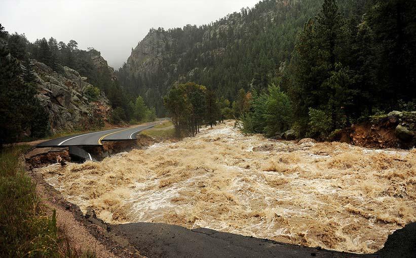
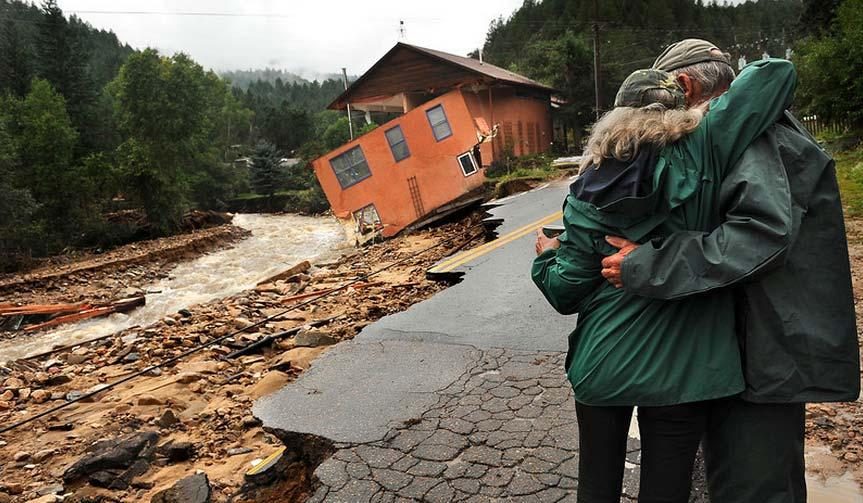
4 20 counties 21,000 households 6000 sq. mi. 2,132 NFIP claims total $64M 10 Fatalities 17 rain in 6 days, 12 average annual 1,882 structures destroyed 16,000 structures damaged Reservoirs filled, spillways activated

5 2013 Colorado Floods 10.7 inches
6 Gilbert White Boulder Creek Floodplain Notebook How do Colorado floodplain managers compose our own Flood Notebooks?
7 Floodplain Mapping Before During After
8
9 @CORIVERDUDE
10 Floodplain Mapping Before Federal FHBMs FIRMs MapMod DFIRMs RiskMAP State Criteria Manual Stream Restoration Floodplain Mapping Local CRS UDFCD - Flash Flood Prediction Program F2P2 Alert Network
11 Colorado State Flood Rules Started in 2009 to carry out statutory mission to reduce flood damages Benefit Cost Analysis required


12 Assumed elevations, assessor building information Detailed DFIRM floodplain analysis
13 Community Storm Water Masterplans Using existing terrain and DFIRM data, review existing and proposed land uses for flood-safe elevations.


14 Flood Smart Elevations Lowest Lot Elevation DFIRM Data Terrain Data Output Parcel Data Flood Depth Flood Smart Finished Floor Elevation Included in outreach materials Highest Flood Elevation
15 Floodplain Mapping Before Federal Better Maps State Better Rules Local Better Data
16
17 Floodplain Mapping During Federal Emergency Response MOTF State EOC CASFM Conference Local Alert Gages Forecasts
18 UDFCD ALERT SYSTEM Started following the 1976 Big Thompson Flood 219 gaging stations 195 rain gages 103 stream gages 26 full weather stations

19 Marston Lake Full Weather Station

20 Rainfall rate alarms, informed forecasters, who updated precipitation models, for Emergency Ops and Public Information

21 Emergency Operation Center National Incident Management Standards GIS links across state

22 Civil Air Patrol Aerial Photos High Water Marks Inundation Mapping

23 Attempts to capture multitude of photo documentation in one place, georeferenced
24 During the Flood During Federal Resources Situational Awareness State Operations Local Emergency Information
25
26 Floodplain Mapping After Federal NFIP Outreach Assistance MOTF State Outreach Assistance Mapping Local BCA Planning
27 LiDAR Led thru USGS FEMA State of Colorado Denver Regional Council of Governments Disaster Relief Fund Federal Operational Support
 Eastern Plains (3,150 sqm) High Relief Mountain (1,261 sqm) Priority 1 & 2 Areas DRCOG AOI: Total 3,600 sq miles")
28 Scope of Work: Project Area Total Project Area: 5,636 sq. Miles plus minimum 100 meter buffer. FEMA AOI s: Mountain Reaches (205 sqm) Eastern Plains (3,150 sqm) High Relief Mountain (1,261 sqm) Priority 1 & 2 Areas DRCOG AOI: Total 3,600 sq miles 2,580 sq mile overlap with FEMA AOI 1,020 sq miles of new area
29
30 Post-Flood Timeline Sept Oct Nov Dec Jan Flood LiDAR flights Priority Delivery Emergency Repairs Master Planning Recovery Mapping Feb Mar Apr May June Advisory FPs & Ordinances Spring runoff designs Spring runoff repairs Terrain delivery BCAs
31 New lidar amazing to come through as quick and during disaster with recovery money Other basins within Colorado were scoped ahead of USGS flood collection and still are not delivered

32 Add cut-fill comparison photo - Sterling

33 Flood Recovery Mapping Advisory BFEs Local Floodplain Ordinance Updates
34 Floodplain Mapping After Federal LiDAR terrain data to support recovery State Recovery flood mapping Assistance Support Local Advisory Mapping Ordinances Master Planning
35 Conclusion What does your flood notebook look like? Does it have a map? Does it have elevations?
36
37 Premise Location Spatial relationship of the data we use as floodplain managers And once we have x,y added to our data, what happens when you add elevation x,y,z is a powerful basis for floodplain management before, during, and after a flood event.
NAI Principles In Gwinnett County
 NAI Principles In Gwinnett County By Cornelius Ani, LSIT, CFM Contributors: Adena Fullard, P.E., CPSWQ Rudresh Bihalli, P.E., CFM Ken Kagy, P.E., CPESC, CPSWQ Ligia Negru, M. Sc., CFM Maja Radovic, CPESC,
Boulder County Comprehensive Drilling Plan Surface Owner Meeting. Thursday, Oct. 19, 2017
 Boulder County Comprehensive Drilling Plan Surface Owner Meeting Thursday, Oct. 19, 2017 Contact Crestone Crestone Peak Resources Quick Facts www.crestonepeakresources.com cdpboulder@crestonepr.com (720)
Boulder County Comprehensive Drilling Plan Surface Owner Meeting. Thursday, Nov. 2, 2017
 Boulder County Comprehensive Drilling Plan Surface Owner Meeting Thursday, Nov. 2, 2017 Contact Crestone Crestone Peak Resources Quick Facts www.crestonepeakresources.com cdpboulder@crestonepr.com (720)
Floodplain Technical Memorandum
 Southeast Extension Project Lincoln Station to RidgeGate Parkway Prepared for: Federal Transit Administration Prepared by: Denver Regional Transportation District May 2014 Table of Contents Page No. Chapter
Hazard Mitigation Planning. Association of New Jersey Environmental Commissions Workshop Edison, New Jersey October 20, 2012
 Hazard Mitigation Planning Association of New Jersey Environmental Commissions Workshop Edison, New Jersey October 20, 2012 Mitigation Planning NJ Hazard Mitigation Plan? What is the status of the HMP
VALUE OF URBAN DRAINAGE PLANNING AND FLOOD HAZARD REDUCTION PROJECTS IN THE 2013 FLOOD
 VALUE OF URBAN DRAINAGE PLANNING AND FLOOD HAZARD REDUCTION PROJECTS IN THE 2013 FLOOD ANDREW EARLES, PH.D., P.E. WRIGHT WATER ENGINEERS, INC. & KEN MACKENZIE, P.E., CFM UDFCD October 11, 2013 Water Resources
MEMORANDUM. September 10, 2018
 September 10, 2018 MEMORANDUM TO: Chad Bird, City of Decorah FROM: Larry Weber and Dan Gilles, Iowa Flood Center, IIHR Hydroscience & Engineering COPY TO: Dana Werner, St. Paul District Corps of Engineers,
City of East Point Comprehensive Floodplain Management Program
 City of East Point Comprehensive Floodplain Management GAFM 2012, 7 th Annual Technical Conference Reza Aral, CFM, CPESC (City of East Point, GA) Shayne Wood, P.E. (CDM Smith) March, 28, 2012 Agenda Overview
Floodplain Management Strategies in Forsyth County Georgia Association of Floodplain Management 7 th Annual Technical Conference March 2012
 Floodplain Management Strategies in Forsyth County Georgia Association of Floodplain Management 7 th Annual Technical Conference March 2012 Renee Hoge, P.E., CFM Forsyth County Department of Engineering
Stormwater Regulations & Considerations Morse Study Area. Pam Fortun, P.E. CFM Senior Stormwater Treatment Engineer Engineering Services Division
 Stormwater Regulations & Considerations Morse Study Area Pam Fortun, P.E. CFM Senior Stormwater Treatment Engineer Engineering Services Division Stormwater Regulations Development Considerations Floodplain
ASFPM 2015 Conference June 3, 2015 Living with the River in Lyons, Colorado. Darrin Punchard, AICP, CFM Principal Risk & Resilience
 ASFPM 2015 Conference June 3, 2015 Living with the River in Lyons, Colorado Darrin Punchard, AICP, CFM Principal Risk & Resilience 1 Lyons, Colorado Located 50 miles north of Denver; 12 miles north of
No Adverse Impact. A Proposed National Standard. Association of State Floodplain Managers Annual Conference Kansas City, MO.
 No Adverse Impact A Proposed National Standard Association of State Floodplain Managers 2017 Annual Conference Kansas City, MO May 3, 2017 Ronald D. Flanagan, CFM Flanagan & Associates, LLC Environmental
Conservation in South Jersey Being Creative with Restoration
 Conservation in South Jersey Being Creative with Restoration Stewardship on a Shoestring: Public Land Management in Fiscally Constrained Times November, 30, 2011 Conservation and Restoration for Open Space
Appendix E Preliminary Location Hydraulic Study
 Appendix E Prepared for: State of Alaska Department of Transportation and Public Facilities Prepared by: HDR Alaska, Inc. 2525 C Street, Suite 305 Anchorage, Alaska 99503 February 2014 This page intentionally
RIVER RECREATION AND CONSERVATION: LESSONS FROM COLORADO S 2013 FLOODS
 RIVER RECREATION AND CONSERVATION: LESSONS FROM COLORADO S 2013 FLOODS SORP RMIS May 2016 L O G A N S I M P S O N Agenda Why Are You Here? Land Use Resiliency Public Outreach Dialogue Recreation and Land
Regional Open Space Conservation Plan. Regional Staff Committee January 18, 2018
 Regional Open Space Conservation Plan Regional Staff Committee January 18, 2018 Schedule We are here Task 1 - Stakeholder Input & Work Plan Dev. v z 2016 2017 2018 Oct Nov Dec Jan Feb Mar Apr May Jun Jul
Village of Forest Park. July 27, Sewer Separation Evaluation
 Village of Forest Park July 27, 2015 Sewer Separation Evaluation Presentation Overview Study Background Historic Nature of Forest Park Drainage Scale of Flooding Problem Forest Park Sewer System Background
Fisher Slough Tidal Marsh Restoration Project Scaling Down the Restoration Planning & Analysis Framework to Evaluate Project Alternatives
 Fisher Slough Tidal Marsh Restoration Project Scaling Down the Restoration Planning & Analysis Framework to Evaluate Project Alternatives Project Sponsor/Partners The Nature Conservancy Dike District #3
City of Waco Stormwater Management Regulations
 1.0 Applicability: City of Waco Stormwater Management Regulations These regulations apply to all development within the limits of the City of Waco as well as to any subdivisions within the extra territorial
1.0 INTRODUCTION 1.1 TH 14 WEST STUDY AREA Project Description Functional Classification Purpose of the Project
 1.0 INTRODUCTION 1.1 TH 14 WEST STUDY AREA 1.1.1 Project Description The Trunk Highway (TH) 14 West Corridor is a two-lane roadway approximately 22 miles in length. Located in Nicollet County, the corridor
October 7, City of Thornton 9500 Civic Center Drive Thornton, CO (303) RE: Maverik Thornton, CO - Drainage Report
 RE: Maverik Thornton, CO - Drainage Report") October 7, 2016 City of Thornton 9500 Civic Center Drive Thornton, CO 80229 (303) 538-7295 RE: Maverik Thornton, CO - Drainage Report As per your request, we are submitting to you the drainage report and
October 7, 2016 City of Thornton 9500 Civic Center Drive Thornton, CO 80229 (303) 538-7295 RE: Maverik Thornton, CO - Drainage Report As per your request, we are submitting to you the drainage report and
STEERING COMMITTEE MEETING # 5 SEPTEMBER 18, 2018
 STEERING COMMITTEE MEETING # 5 SEPTEMBER 18, 2018 STEERING COMMITTEE MEETING #5 AGENDA 1. Introduction 2. Market Conditions 3. Preliminary Development Concepts 4. Open Discussion 5. Next Steps PLANNING
CHECKLIST FOR PHASE II DRAINAGE REPORT
 I. COVER SHEET CHECKLIST FOR PHASE II DRAINAGE REPORT A. Name of Project B. Address C. Owner D. Developer E. Engineer F. Submittal date and revision dates as applicable II. GENERAL LOCATION AND DESCRIPTION
I. INTRODUCTION. identify long-term capital improvements and rehabilitation measures for the existing drainage system;
 I. INTRODUCTION The Town of Windsor, Colorado is presently experiencing rapid growth and development within the boundaries of several of its major drainage basins. As growth continues within these basins,
Floodplain Management Plan 2016 Progress Report
 PREPARED FOR: Borough of Point Pleasant Beach 416 New Jersey Ave. Point Pleasant Beach, NJ 08742 (732) 892-1118 http://www.pointpleasantbeach.org/ PREPARED BY: T&M Associates 11 Tindall Road Middletown,
7th Avenue Creek Master Plan Development Project. City of St. Charles, IL. IAFSM CONFERENCE March 14, 2018 MARKET
 7th Avenue Creek Master Plan Development Project MARKET City of St. Charles, IL IAFSM CONFERENCE March 14, 2018 7 TH AVENUE CREEK PROJECT AREA 2 2008 RAIN EVENT 3 RESIDENTIAL STRUCTURE FLOODING COMMERCIAL
FLOOD ISSUE 62 INTRODUCTION
 V I S I O N 2 0 3 0 Southwest Missouri is known for its extreme range in weather that can cause flash flooding in a moment s notice. This flooding can unfortunately lead to extreme damage and serious injury,
SPANISH TOWN, ST. CATHERINE JAMAICA
 SPANISH TOWN, ST. CATHERINE JAMAICA This presentation is aimed at emphasizing the importance of an effective community flood alert component of Community Flood Warning Systems (CFWS) in vulnerable communities
QUESTIONS AND ANSWERS Windsor Woods, Princess Anne Plaza & The Lakes Combined Drainage Project
 QUESTIONS AND ANSWERS Windsor Woods, Princess Anne Plaza & The Lakes Combined Drainage Project PROJECT OVERVIEW Windsor Woods, Princess Anne Plaza and The Lakes are neighborhoods located in what was once
Hydrologic Assessment of using Low Impact Development to Mitigate the Impacts of Climate Change. Chris Jensen, AScT Master of Science Thesis
 Hydrologic Assessment of using Low Impact Development to Mitigate the Impacts of Climate Change Chris Jensen, AScT Master of Science Thesis Bowker Creek Initiative April 12, 2012 Outline 1. Future Impacts
Radnor Township. Factors affecting storm water issues.
 Radnor Township Factors affecting storm water issues. Climate Changes and Changing Weather Patterns Intensity of rains over the last 7 to 10 years. Larger number of smaller storms delivering greater amounts
Poisoned Park? How Exide s Lead Contamination Risks Frisco s Grand Park
 Frisco City Hall has big plans to transform Stewart Creek into a Grand Park with lots of water features for kids to play in. Poisoned Park? How Exide s Lead Contamination Risks Frisco s Grand Park But
Modeling Cumulative LID Features for Floodplain Impacts in an Urban Watershed in Houston, TX
 Modeling Cumulative LID Features for Floodplain Impacts in an Urban Watershed in Houston, TX Christina Hughes, Phil Bedient cmhughes@rice.edu May 2, 2014 1 Modeling Cumulative LID Features for Floodplain
LOW IMPACT DEVELOPMENT GUIDANCE MANUAL AND LID WORKING GROUP ACTIVITIES. Powerpoint Templates. MS4 Statewide Stormwater Summit June 18, 2013
 LOW IMPACT DEVELOPMENT GUIDANCE MANUAL AND LID WORKING GROUP ACTIVITIES MS4 Statewide Stormwater Summit June 18, 2013 Powerpoint Templates Evan Canfield, Ph.D, P.E. Pima County Regional Flood Control Outline
City of Norfolk Coastal Flood Mitigation Program. March 13, 2013
 City of Norfolk Coastal Flood Mitigation Program March 13, 2013 Topics Brief overview of Norfolk s Coastal Flood Program Data-driven analysis and decision making City-wide vulnerability, project concepts,
Nevada Floodplain Management Program
 Nevada Floodplain Management Program Mt Rose Highway-NHP February 2017 - Courtesy NWS Reno East Fork Carson River January 2017 Douglas County, NV - Courtesy Courtney Walker I 15, Overton 9/10/14 Rye Patch
1. Project Description
 To: By: Checked By: Jimmy Vilce, E.I. (FOT istrict 1 Project Manager) Jennifer Nunn, P.E. (The Balmoral Group) Lori Stanfill, P.E. (The Balmoral Group) Memorandum ate: July 10, 2018 Subject: In May of
HYDROLOGICAL PERFORMANCE OF THE GREEN ROOF AT SYRACUSECOE
 HYDROLOGICAL PERFORMANCE OF THE GREEN ROOF AT SYRACUSECOE DIMITAR TODOROV 1,2 AND CHARLES DRISCOLL 2 1 UTICA COLLEGE, UTICA NY 2 SYRACUSE UNIVERSITY, SYRACUSE, NY OUTLINE BACKGROUND INFORMATION AND SITE
CRITICALFACILITIESASSESSMENT IN SOUTHEASTERN CONNECTICUT STRATEGIES FOR ALL HAZARDS RESILIENCE
 CRITICALFACILITIESASSESSMENT IN SOUTHEASTERN CONNECTICUT STRATEGIES FOR ALL HAZARDS RESILIENCE Presented by: David Murphy, P.E., CFM, Milone & MacBroom, Inc. October 25, 2017 Agenda Project Background
KYTC and NFIP: Bridging Floodplain Management and Design KAMM CONFERENCE AUGUST 25, 2015
 KYTC and NFIP: Bridging Floodplain Management and Design KAMM CONFERENCE AUGUST 25, 2015 KYTC STATEWIDE DRAINAGE DESIGN Provide Drainage Design Services on an as needed basis: Perform hydraulic analysis
Existing Conditions and Environmental Consequences Floodplains
 3.9 Environmental Consequences 3.8 3.8.1 WHAT ARE FLOODPLAINS? are low-lying areas adjacent to rivers, streams, and other waterbodies that are susceptible to inundation (flooding) during rain events. These
Slow it, Spread it, Sink it using Green Stormwater Infrastructure
 Milly Archer Water Resources Coordinator Becky Tharp Green Infrastructure Collaborative Slow it, Spread it, Sink it using Green Stormwater Infrastructure Overview Defining LID and GSI Hydrology and impacts
A G E N D A Council Update Training Room September 26, :45 p.m.
 CITY OF THORNTON CITY MANAGER S OFFICE A G E N D A Council Update Training Room September 26, 2017 5:45 p.m. A. Boards and Committees Reports (Estimated 20 Minutes) 1. Rangeview Library District Meeting
Roof Runoff Harvesting Benefits for Regional Conditions in Low Density and Medium Density Residential Areas. Leila Talebi 1 and Robert Pitt 2
 Roof Runoff Harvesting Benefits for Regional Conditions in Low Density and Medium Density Residential Areas Leila Talebi 1 and Robert Pitt 2 1Graduate Student, Department of Civil, Construction, and Environmental
QUESTIONS AND ANSWERS Windsor Woods, Princess Anne Plaza & The Lakes Combined Drainage Project
 QUESTIONS AND ANSWERS Windsor Woods, Princess Anne Plaza & The Lakes Combined Drainage Project Project Overview... 2 Thalia Creek (Windsor Woods) Tide Gate... 6 Club House Road Drainage Project... 9 Updated
When planning stormwater management facilities, the following principles shall be applied where possible.
 2.0 Principles When planning stormwater management facilities, the following principles shall be applied where possible. 2.0.1 Drainage is a regional phenomenon that does not respect the boundaries between
ATTACHMENT 1 WILSON MINE LECROY AREA SEMIPERMANENT DEWATERING SYSTEM
 ATTACHMENT 1 WILSON MINE LECROY AREA SEMIPERMANENT DEWATERING SYSTEM Reclamation plans for the Wilson Mine Lecroy area were approved by the Arkansas Department of Environmental Quality with a passive barrier
The Benefits and Challenges Associated with Green Infrastructure Practices
 The Benefits and Challenges Associated with Green Infrastructure Practices Thomas M. Evans ASLA, LEED AP Regional Green Infrastructure Design Services Director OWEA Technical Conference, June 20, 2013
- Phase. Project. areas using. project from. Project Type: Project is
 Model Community Watershe ed Development - Phase I / Marais des Cannes Location: Lafayette Parish / Scott, LA Client: State of Louisiana / Office of Community Development Disaster Recovery Unit Design Firm(s):
BE WATER WISE. Managing Your Onlot Stormwater. Sept. 23, 2006 Watershed Weekend
 BE WATER WISE Managing Your Onlot Stormwater Sept. 23, 2006 Watershed Weekend 2006 1 All water resources are interrelated through the Hydrologic Cycle Sept. 23, 2006 Watershed Weekend 2006 2 What is Storm
Swatara Township Stormwater Program. 1. There are no storm sewers on or near my property. Why should I pay a fee?
 1. There are no storm sewers on or near my property. Why should I pay a fee? All properties produce stormwater runoff that must be managed by the Township. Even if your property has never flooded and there
8.5 FLOODING. Environmental Setting
 8.5 FLOODING This section evaluates flooding impacts associated with the proposed General Plan, including whether implementing the plan will: (1) permit the construction of housing within a 100-year Flood
FLOODPLAIN USE PERMIT APPLICATION COMMUNITY DEVELOPMENT DEPARTMENT W. Ten Mile Road Novi, MI (248)
") FLOODPLAIN USE PERMIT APPLICATION COMMUNITY DEVELOPMENT DEPARTMENT 45175 W. Ten Mile Road Novi, MI 48375 (248) 347-0415 Office Use Only Permit Number: Date Issued: Processed By: Type of Permit: Date: Project
FLOODPLAIN USE PERMIT APPLICATION COMMUNITY DEVELOPMENT DEPARTMENT 45175 W. Ten Mile Road Novi, MI 48375 (248) 347-0415 Office Use Only Permit Number: Date Issued: Processed By: Type of Permit: Date: Project
Part 4: CRS Stormwater Management Activity (450) and Urban Flooding Best Practices
 and Urban Flooding Best Practices") Coastal Resilience through Community Engagement Webinar Series Part 4: CRS Stormwater Management Activity (450) and Urban Flooding Best Practices 1:00 2:30pm CT 8 Today s Moderator Chad Berginnis, CFM
Coastal Resilience through Community Engagement Webinar Series Part 4: CRS Stormwater Management Activity (450) and Urban Flooding Best Practices 1:00 2:30pm CT 8 Today s Moderator Chad Berginnis, CFM
A TWENTY YEAR PLAN TO RESTORE NAPLES BAY. Natural Resources Manager
 A TWENTY YEAR PLAN (and visionary guide) TO RESTORE NAPLES BAY Michael R. Bauer, Ph.D. Natural Resources Manager City of Naples City of Naples Natural Resources Division Management Science Restoration
Problem Understanding
 Introduction...2-1 Previous Data and Mapping...2-2 Known Problem Areas...2-3 Resident Survey.2-3 Introduction The Village of Downers Grove stormwater system includes storm sewers, streams, wetlands, roadway
Citywide Integrated Stormwater Management Plan (ISMP) DRAFT ACTION PLAN REVIEW Public Consultation November 16 th, 2016
 DRAFT ACTION PLAN REVIEW Public Consultation November 16 th, 2016") Citywide Integrated Stormwater Management Plan (ISMP) DRAFT ACTION PLAN REVIEW Public Consultation November 16 th, 2016 1 Agenda DRAFT ACTION PLAN REVIEW Public Consultation Time 6:00 6:05 6:05 6:20 6:20
Citywide Integrated Stormwater Management Plan (ISMP) DRAFT ACTION PLAN REVIEW Public Consultation November 16 th, 2016 1 Agenda DRAFT ACTION PLAN REVIEW Public Consultation Time 6:00 6:05 6:05 6:20 6:20
water resource specialists
 Vaughn Collins, PE, CFM, Northwest Hydraulic Consultants Brad Livingston, Oregon Department of Transportation Melissa Reich, North Coast Land Conservancy Location Necanicum River 75 sq mi watershed Active
DAM BREACH EMERGENCY PLAN SKI ISLAND LAKE, OKLAHOMA CITY
 DAM BREACH EMERGENCY PLAN SKI ISLAND LAKE, OKLAHOMA CITY 1. PURPOSE This plan has been designed to warn and evacuate an area downstream from Ski Island Lake, near the intersection of West Hefner Road and
MASTER PLAN KICK-OFF Open House #1A, April 28, 2015
 "The beginning is the most important part of the work." Plato, The Republic MASTER PLAN KICK-OFF Open House #1A, April 28, 2015 YOUR CAMPUS PLANNING TEAM Campus Planners Landscape Architects Urban Designers
Landowner's Guide to the Lower St. Croix Riverway. Protect. Restore. Celebrate. stcroixriverassociation.org
 Landowner's Guide to the Lower St. Croix Riverway Protect. Restore. Celebrate. stcroixriverassociation.org Cover and page spread photographs by Craig Blacklock. For more information on how to be a river
Low Impact Development Calculations using the Source Loading and Management Model (WinSLAMM)
") Low Impact Development Calculations using the Source Loading and Management Model (WinSLAMM) Robert Pitt Department of Civil, Construction, and Environmental Engineering The University of Alabama, Tuscaloosa,
Low Impact Development Calculations using the Source Loading and Management Model (WinSLAMM) Robert Pitt Department of Civil, Construction, and Environmental Engineering The University of Alabama, Tuscaloosa,
Green Infrastructure Planning for Sustainability and Resiliency
 Green Infrastructure Planning for Sustainability and Resiliency Linking Lands and Communities in the Land-of-Sky Region SAMAB Conference - November 18, 2010 www.linkinglands.org Linda Giltz, AICP, Regional
Don t Flood The Rodeo! Preparing for Fort Worth s New Arena
 Don t Flood The Rodeo! Preparing for Fort Worth s New Arena T F M A S P R I N G C O N F E R E N C E APRI L 27 2017 Scott Hubley, P.E., CFM Justin Oswald, P.E., CFM Christopher Johnson, P.E., CFM PHOTO
Physical Approaches to Flood Mitigation
 Physical Approaches to Flood Mitigation ational Academy of Sciences /19/2017 Chicago Area Before Development Widespread Flooding Waterways and Marshes Absorbent Ground Early settlers came to this location
2014 HAZARD MITIGATION PLAN ANNUAL REVIEW. Consider receiving the 2014 Hazard Mitigation Plan annual review.
 STAFF REPORT MEETING DATE: July 22, 2014 TO: FROM: City Council Police Chief James Berg 922 Machin Avenue Novato, CA 94945 (415) 899-8900 FAX (415) 899-8213 www.novato.org SUBJECT: 2014 HAZARD MITIGATION
Adopting the Manual of Best Management Practices for Stormwater Quality. Facts for Communities
 Adopting the Manual of Best Management Practices for Stormwater Quality Facts for Communities Adopting the Manual of Best Management Practices for Stormwater Quality September 2006 prepared for the Mid-America
The Role of the Landscape Contractor to Conserve Water
 The Role of the Landscape Contractor to Conserve Water By Richard Restuccia, Sales Leader Western U.S. ValleyCrest Landscape Maintenance rrestuccia@valleycrest.com Abstract Opportunities abound for property
Getting the Locals to Go Along. Keys to Tulsa s Successful Floodplain Management
 Getting the Locals to Go Along Keys to Tulsa s Successful Floodplain Management Presented by: Ronald D. Flanagan, CFM Principal Planner Flanagan & Associates, LLC Land-Use & Natural Hazards Planning Consultants
TOWN OF BEDFORD CONSERVATION COMMISSION
 PUBLIC NOTICE DRAFT Work Plan The is in the process of forming a subcommittee that will be studying the of Exceptional Value and their importance to the Town of Bedford. This document will serve as the
4-H SOIL & WATER PROJECT UPDATE. Indiana 4-H. Youth Education
 4-H SOIL & WATER Indiana 4-H Youth Education PROJECT UPDATE PRESENTATION OUTLINE Project Background What, Why, How? Who are the Partners? What is 4-H Youth Education? Project Goals How will 4-H Implement?
Blake C. Kronkosky, PE, Ph.D.
 Blake C. Kronkosky, PE, Ph.D. Blake.Kronkosky@statetecheng.com, CELL (512) 663-1954 Education Ph.D., Civil Engineering, Texas Tech University, May 2018: An Engineer's Guide for Estimating 1-Day, 100-Year
City of Elmhurst. Comprehensive Flood Plan. City of Elmhurst. City Council Meeting September 15, 2014
 City of Elmhurst City of Elmhurst Comprehensive Flood Plan City Council Meeting September 15, 2014 City of Elmhurst Presentation Overview Study Background Study Methodology Analysis of Three Additional
What is stormwater runoff? Why is it a problem? Available Financial Incentives for Stormwater BMP s Downspout Disconnection - up to $20
 What is stormwater runoff? Stormwater is any form of natural precipitation (including ice and snow melt) that flows across undeveloped or developed land. In a natural setting, a majority of the water seeps
A Functional Annex Alert and Warning
 A Functional Annex Alert and Warning Approved (June 3, 2004) This page left blank intentionally Table of Contents 1 Purpose... 3 2 Situation and Assumptions... 3 2.1 Situation... 3 2.2 Assumptions... 4
Planning for Historic/Cultural Resources Coastal Resiliency in Connecticut. Presented to CAFM s 3 rd Annual Conference
 Planning for Historic/Cultural Resources Coastal Resiliency in Connecticut Presented to CAFM s 3 rd Annual Conference October 25, 2016 Agenda Introduction and Project Overview Background Historic and Cultural
Empowering Local Action for Coastal Resilience in Massachusetts. Bruce K. Carlisle MA Office of Coastal Zone Management
 Empowering Local Action for Coastal Resilience in Massachusetts Bruce K. Carlisle MA Office of Coastal Zone Management Context Coastal communities continue to face both chronic and acute storm surge, erosion,
Physical Map Revision Flood Insurance Study
 Physical Map Revision Flood Insurance Study Collin County, Texas Over the Shoulder Review Meeting Draft Floodplain Mapping 1 October 26, 2011 Presentation Overview Introductions and Sign in Meeting Purpose
Weston s Wetlands, Stormwater, & Open Space
 Weston s Wetlands, Stormwater, & Open Space Weston s Wetlands, Stormwater, & Open Space Conservation Commission Role and Responsibilities Laws that protect wetlands What residents can do to protect wetlands
Adapting Floodplain Ordinances to New Mapping in Historically Modified Floodplains for Urban Areas
 Adapting Floodplain Ordinances to New Mapping in Historically Modified Floodplains for Urban Areas By: Raymond J. Wilke, P.E., CFM City of Atlanta Watershed Director, Senior Bureau of Engineering Services
Outflow to Saw Mill Run
 Dormont Stormwater Fee Frequently Asked Questions What is stormwater, and why is it a problem in Dormont? Stormwater is runoff from rain or snow that falls and flows to Little Saw Mill Run or McNeilly
Kimberly Rollins, Professor, Department of Economics, University of Nevada, Reno
 Modeling Multiple Factors of Residential Water Demand to Assess Price and Non-Price Instruments under Climate Change: An Application to Las Vegas, Nevada Kimberly Rollins, Professor, Department of Economics,
Stormwater Management at The University of New Orleans
 University of New Orleans ScholarWorks@UNO DRU Workshop 2013 Presentations Disaster Resistant University Workshop: Linking Mitigation and Resilience Conferences and Workshops 3-1-2013 Stormwater Management
EXHIBIT A CITY OF FORT WALTON BEACH, FLORIDA COASTAL MANAGEMENT & CONSERVATION
 EXHIBIT A CITY OF FORT WALTON BEACH, FLORIDA INTRODUCTION The Coastal Management and the Conservation Elements required by Chapter 9J-5.012 and 5.013, F.A.C., respectively, have been combined into one
Rt 29 Solutions Hydraulic Planning Advisory Panel. September 14, 2017
 Hydraulic Planning Advisory Panel September 14, 2017 Agenda Item 1: Introductions Hydraulic Planning Advisory Panel members Technical Team members 2 Agenda item 2: Public Interaction and Feedback Live
Santa Cruz River Master Plan. Presented to the Arizona Floodplain Management Association Spring Conference June 8-10, 2011
 Santa Cruz River Master Plan Presented to the Arizona Floodplain Management Association Spring Conference June 8-10, 2011 Introduction Who is FICO? 2 Project Team Kimley-Horn and Associates, Inc. River
Deer Creek Watershed Stakeholders Committee
 Deer Creek Watershed Stakeholders Committee Stakeholder Partners East West Gateway Council of Governments Great Rivers Greenway District Local Municipalities Metropolitan St. Louis Sewer District Missouri
The Rocky Mountain Arsenal and the Northeast Greenway Corridor Project:
 The Rocky Mountain Arsenal and the Northeast Greenway Corridor Project: Contamination to Collaboration Presented by Howard Kenison Overview of Presentation Rocky Mountain Arsenal Contamination Litigation,
CITY OF HOLLY SPRINGS STORMWATER UTILITY FREQUENTLY ASKED QUESTIONS
 CITY OF HOLLY SPRINGS STORMWATER UTILITY FREQUENTLY ASKED QUESTIONS GENERAL What is a Stormwater Utility and why is it needed in Holly Springs? A Stormwater Utility is an entity responsible for the daily
Highlands Region Stormwater Management Program Guidance
 DRAFT Highlands Region Stormwater Management Program Guidance Release Date: January 2016 Abstract This guidance document provides an overview of the Highlands Stormwater Management Program. It is intended
STORMWATER UTILITY FREQUENTLY ASKED QUESTIONS
 STORMWATER UTILITY FREQUENTLY ASKED QUESTIONS What is Stormwater? Stormwater is water that falls to the ground during a precipitation event. When land is undeveloped or covered with vegetative surface,
Jill Stachura STORMWATER BMP AND STREAM RESTORATION IN A CITY PARK. October 2013 Southeast Stormwater Association Annual Conference, Charlotte, NC
 Jill Stachura STORMWATER BMP AND STREAM RESTORATION IN A CITY PARK October 2013 Southeast Stormwater Association Annual Conference, Charlotte, NC Project Location Gwinnett County, GA: Population: 825,000
Green Inspirations for Landscapes
 Master Gardener Conference 2010 Green Inspirations for Landscapes Carl I. Evensen Associate Dean/Director Cooperative Extension OUTLINE: Hawaiian Hydrology Urban Runoff and Pollution Green Landscaping
City of Manassas Park Proposed Stormwater Management Funding
 City of Manassas Park Proposed Stormwater Management Funding October 5, 2010 State and Federal Storm Water Mandates The State mandates implementation of ordinance, programs, and practices to meet storm
City of Elyria. Frequently Asked Questions
 City of Elyria Stormwater Utility Program Prepared by: April 2014 (version 1) Page 1 City of Elyria Stormwater Utility Program Stormwater Utility Program Q. What is a Stormwater Utility? A. A stormwater
Rainfall, Streamflow, and Water-Quality Data During Stormwater Monitoring, Halawa Stream Drainage Basin, Oahu, Hawaii, July 1, 2000 to June 30, 2001
 U.S. Department of the Interior Rainfall, Streamflow, and Water-Quality Data During Stormwater Monitoring, Halawa Stream Drainage Basin, Oahu, Hawaii, July 1, 2 to June 3, 21 U.S. GEOLOGICAL SURVEY Open-File
ELIGIBILITY CRITERIA CHECKLIST OPEN SPACE CLASSIFICATION
 THURSTON COUNTY DEVELOPMENT SERVICES OPEN SPACE TAX PROGRAM ELIGIBILITY CRITERIA CHECKLIST OPEN SPACE CLASSIFICATION Use this checklist to help you determine whether your property is eligible for open
Priorities. Public Communication & Transparency Website, CM Public Updates, Magic City Newsletter
 Priorities Recognition & Thanks to public servant employees Public Communication & Transparency Website, CM Public Updates, Magic City Newsletter Citizen/Customer Service Fiscal Responsibility Flood Protection
ICON engineering, inc.
 7000 South Yosemite Street, Suite 120, Centennial, CO 80112 (303) 221-0802 www.iconeng.com ICON engineering, inc. University of Colorado Boulder Statement of Qualifications January 31, 2018 1997 2017 TABLE
Tracking spatiotemporal patterns of building vulnerabilities and evacuations during flood hazards
 Tracking spatiotemporal patterns of building vulnerabilities and evacuations during flood hazards Shane Hubbard Junchuan Fan Kathleen Stewart Emily White The University of Wisconsin Madison, SSEC/CIMSS