SPANISH TOWN, ST. CATHERINE JAMAICA
|
|
|
- Timothy Houston
- 6 years ago
- Views:
Transcription
1 SPANISH TOWN, ST. CATHERINE JAMAICA
2 This presentation is aimed at emphasizing the importance of an effective community flood alert component of Community Flood Warning Systems (CFWS) in vulnerable communities of small island developing states (SIDS), and prioritizing expenditure on Comprehensive Disaster Management in the development process.
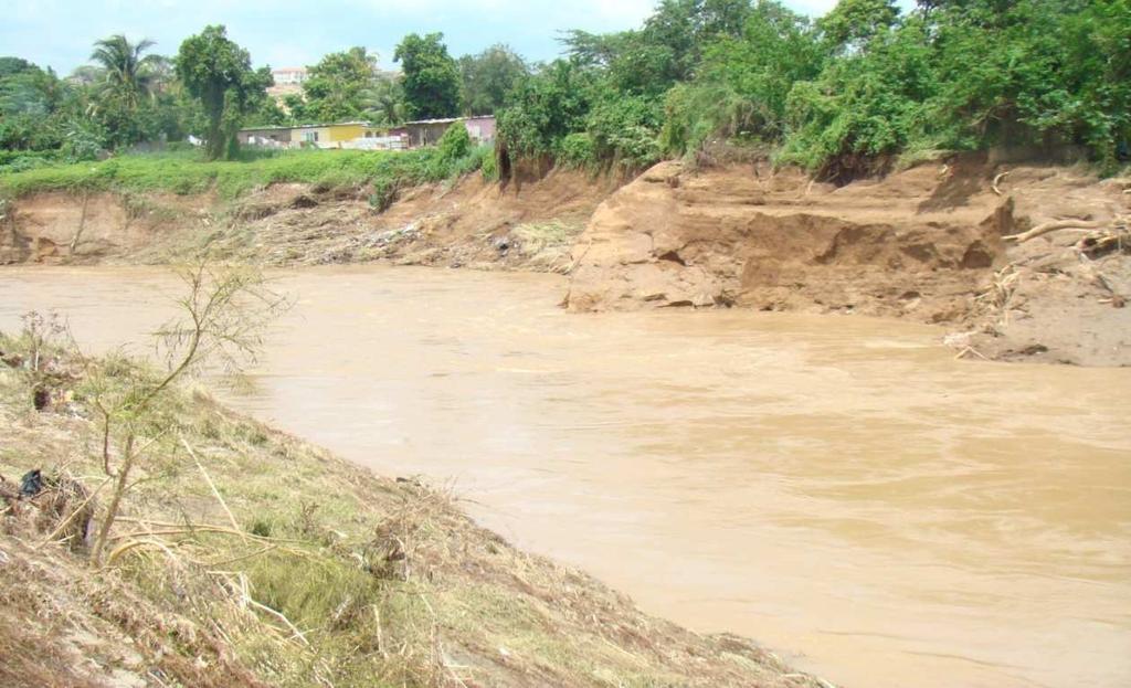
3 The Rivoli and Thompson Pen communities - located on the eastern and western banks of the Rio Cobre respectively, approximately 3 kilometers below the Rio Cobre irrigation Dam - Approximately 20 kilometers from Kingston - Approximately 450 homes and 5000 residents living within the 100yr flood boundary - Major flooding events have occurred 14 times in 54 years ( ) with an average of one flood every 3 years.

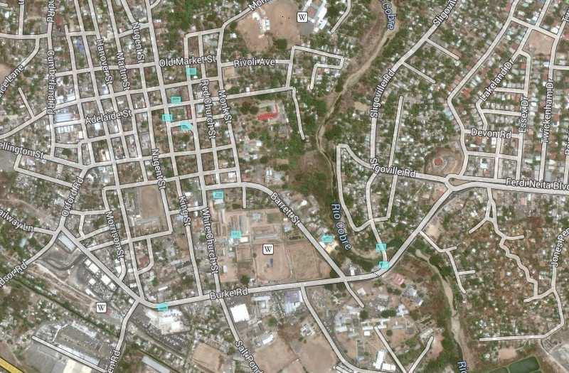
4 Rivoli Thompson pen
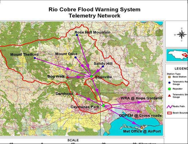
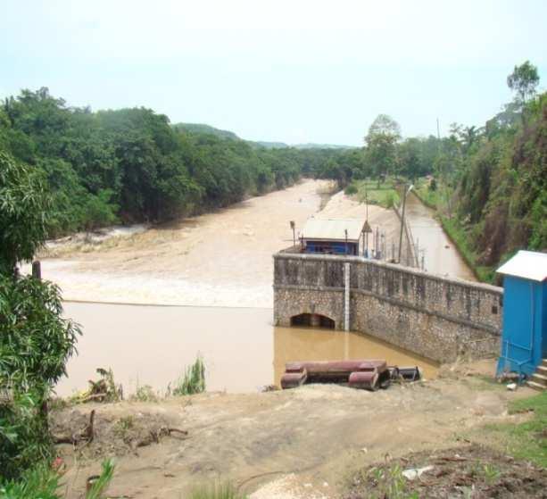
5 The Rio Cobre drainage area covers 520 km 2 consisting of steep sloping mountains, rolling hills and plains. There are 5 major tributaries of the Rio Cobre that drains the upper basin. These tributaries usually generate peak flood flows at varying times during a rain storm causing unpredictable flooding conditions in the Rivoli and Thompson Pen communities. Real Time and Community Flood Warning Systems have been implemented and upgraded in the Rio Cobre Basin by the UNDP since 1989 but the Community Food Warning Component did not include an electrical alarm device. Based on a request from the community a Flood Alarm System was funded and installed by Help Age International in November 2012.
6 PREDICTION- Forecast of Advance Weather Systems DETECTION- Monitoring of Rainfall and River Levels COMMUNICATION - Relaying Messages by various means DECISION MAKING - Take action based on established criteria MOBILIZATION - Decision on program for evacuation
7 The initial Community Flood Warning System includes the installation of colour coded flood gauges with blue yellow and red colours indicating Normal Alert and Critical flood levels. Flood level thresholds are set for each of the above levels and actions to be taken documented and circulated within the community. The established alert rainfall depth in the upper Rio Cobre basin that will cause flooding is 100mm (4 inches) in 6 hours. The flood level at the beginning of the gorge that will cause flooding is 2.6 meters (8feet). This information is transmitted in real time to computers and cell phones of selected monitoring officers at the Water Resources Authority and the ODPEM who then communicate the information to the Parish Disaster Coordinator and the communities.
8 In 2012 the residents of the communities of Rivoli and Thompson Pen requested the installation of an Alarm System based on the following justification. Some residents were not alerted in a timely manner during major floods. Most floods occur at nights when residents are asleep. Localized flooding may occur resulting from rainfall and flood levels not detected by the real time monitoring system. Residents can be alerted by alarm without endangering the lives of gauge readers who has to monitor flood levels at night. The river could reach the critical level several times in one day while complacency could set in after the first flooding event. The community is alerted without dependence on runners or cell phones. The community will provide a location for installation of the alarm equipment at a home where it is secure and properly maintained.
9 The main purpose of the alarm system is to enhance the existing community flood warning system in a way that will ensure that: - the alerts or warnings reach the most vulnerable in a timely manner. Note: It is not meant to replace the original system.
10 The Flood Alarm warning system is designed to alert citizens of a possible threat of flooding in or out of the hurricane season. The system is controlled electronically and includes devices that require periodical maintenance and testing. Components 12v relay Solar panel 12 v rechargeable battery Electronic key switch (Howler disabler) Test push button switch Electronic howler Water sensor switch Operation
11
12 The water sensor is fixed within a metal housing near the community flood gauge located on the bank of the river. When the river level rises,the sensor reads the water level and sends voltage to the control panel.the control panel then takes the information and forwards it to the howler located beneath the eve of the building to produce the alarm. The 12 v battery provides power to operate the circuit and the howler, while the solar panel maintains a trickle charge to the battery.
13 To alert the Rivoli and Thompson Pen community especially at nights when flooding may suddenly occur. Note: - The Howler is activated when the flood gauge level of 7ft is breached. -The alarm can be turned off manually by a key attached to the control box -The community will decide the frequency and duration of the alarm sound


14 Plate 14: Installing Alarm Sensor Cable Plate 15: Alarm System Box Plate 16: Float Sensor Switch


15 Plate 17: Solar Panel and Howler Siren Plate 18: Testing the Alarm System
16 CHALLENGES Acceptance and ownership of the system Community willingness to participate Sustainability and maintenance of the system Adequacy of monitoring network and communication system BENEFITS OF FLOOD WARNING SYSTEM Improves the awareness of the community about flooding so that they are better able to anticipate and respond to future flood. It lengthens the lead time before a flood so that the community can adequately provide for evacuation if necessary. Save lives and reduce the cost of damage to property. Promotes community integration and participation Promotes a change of culture and environmental awareness. Improves cooperation among agencies and enhances private and public partnership. Improves security and provide social trust.
17
18
19
Early Warning Systems for. Natural Disasters in Korea
 EWC III Bonn, March 2006 Early Warning Systems for Natural Disasters in Korea Sam-Kew ROH, Ph.D. National Institute for Disaster Prevention National Emergency Management Agency Republic of Korea 2 Background
Disaster Mitigation of Debris Flows, Slope Failures and Landslides 759
 Disaster Mitigation of Debris Flows, Slope Failures and Landslides 759 Disaster Monitoring and Warning System by the Niigata Prefectural Government after the Mid Niigata Prefecture Earthquake Yukihiko
Urban Fires & Wildfires November 3, 2009
 Unincorporated Urban Fires & Wildfires November 3, 2009 Plan Update Flanagan & Associates, LLC Consultants Tulsa, OK www.rdflanagan.com rdflanagan@rdflanagan.com Plan can be reviewed at: www.rdflanagan.com/county.html
King William County Board of Supervisors Vision Statement
 King William County Board of Supervisors Vision Statement King William County envisions a united community built on the foundation of its past, the strength of its diverse population and the promise of
City of Norfolk Coastal Flood Mitigation Program. March 13, 2013
 City of Norfolk Coastal Flood Mitigation Program March 13, 2013 Topics Brief overview of Norfolk s Coastal Flood Program Data-driven analysis and decision making City-wide vulnerability, project concepts,
Professional tool for protection of 1 human lives, health and properties
 Professional tool for protection of 1 human lives, health and properties Introduction Leos Nevole Senior Key Account Manager mob.: +420 724 132 872; nevole@colsys.cz COLSYS s.r.o. Czech ownership 26 years
7. EMERGENCY MANAGEMENT
 7. EMERGENCY MANAGEMENT The Clallam County Emergency Management Division operates a Comprehensive Emergency Management Plan jointly with the cities of Port Angeles, Sequim, and Forks using the Incident
4. UTILITIES ELEMENT.
 4. UTILITIES ELEMENT. The purpose of this element is to provide for necessary public facilities and services correlated to future land use projections and population demand. Utilities Sub-Elements (A)
Adaptation and Resilience at the City of Fort Lauderdale
 Adaptation and Resilience at the City of Fort Lauderdale Carlos Acosta, P.E. Assistant City Engineer City of Fort Lauderdale Overview Climate challenges and limitations Sea Level Rise Projections King
If you Google Disaster Recovery, you will get approximately 47,700,000 hits.
 DISASTER RECOVERY If you Google Disaster Recovery, you will get approximately 47,700,000 hits. Disaster Planning and Prevention are the keys to Disaster Recovery. Those who forget the past are condemned
Mapping and the 2013 Colorado Floods. Mapping before, during, and after
 Mapping and the 2013 Colorado Floods Mapping before, during, and after Presented by Outline 2013 Floods Floodplain Mapping Before During After 20 counties 21,000 households 6000 sq. mi. 2,132 NFIP claims
NAI Principles In Gwinnett County
 NAI Principles In Gwinnett County By Cornelius Ani, LSIT, CFM Contributors: Adena Fullard, P.E., CPSWQ Rudresh Bihalli, P.E., CFM Ken Kagy, P.E., CPESC, CPSWQ Ligia Negru, M. Sc., CFM Maja Radovic, CPESC,
CHECKLIST FOR PHASE II DRAINAGE REPORT
 I. COVER SHEET CHECKLIST FOR PHASE II DRAINAGE REPORT A. Name of Project B. Address C. Owner D. Developer E. Engineer F. Submittal date and revision dates as applicable II. GENERAL LOCATION AND DESCRIPTION
Flood Monitoring and Early Warning System Using Ultrasonic Sensor
 IOP Conference Series: Materials Science and Engineering PAPER OPEN ACCESS Flood Monitoring and Early Warning System Using Ultrasonic Sensor To cite this article: J G Natividad and J M Mendez 2018 IOP
Exhibit A Comprehensive Plan Amendments
 Exhibit A Comprehensive Plan Amendments May 2010 Draft Chapter One - Introduction Chapter One INTRODUCTION NOTE: For brevity and ease in viewing the proposed changes, portions of chapter one that are not
PUBLIC SERVICES ELEMENT GOALS / POLICIES / MEASURES
 PUBLIC SERVICES ELEMENT GOALS / POLICIES GOALS / POLICIES / MEASURES Authority The Public Services Element addresses provision of municipal services to City residents. The following paragraphs provide
Understanding Stormwater Drainage Maintenance
 WARREN COUNTY STORMWATER DISTRICT Understanding Stormwater Drainage Maintenance Home Owner s Association Guide Introduction Our goal is to help property owners and Home Owner s Associations (HOA) understand
MINISTRY OF THE INTERIOR CHIEF-DIRECTORATE FIRE SAFETY AND CIVIL PROTECTION DISASTERS RESPONSE AND UNIFIED RESCUE SYSTEM
 MINISTRY OF THE INTERIOR CHIEF-DIRECTORATE FIRE SAFETY AND CIVIL PROTECTION DISASTERS RESPONSE AND UNIFIED RESCUE SYSTEM LAW ON THE MoI CHIEF DIRECTORATE FIRE SAFETY AND CIVIL PROTECTION - MoI With the
City of Waco Stormwater Management Regulations
 1.0 Applicability: City of Waco Stormwater Management Regulations These regulations apply to all development within the limits of the City of Waco as well as to any subdivisions within the extra territorial
Support the implementation of Cape Coral's Comprehensive Plan. Protect and utilize the unique natural resources in the City.
 7.0 OVERVIEW - RECOMMENDATIONS Chapter 7 The preparation of the Cape Coral Parks and Recreation Master Plan spanned a period of approximately 12 months. Plan preparation included the input of a wide range
Town/Village of Waterford Multi-Hazard Evacuation Plan
 Town/Village of Waterford Multi-Hazard Evacuation Plan July 2013 Prepared by: John Tanchak Public Safety Commissioner Evacuation Plan Purpose: The purpose of the Town/Village of Waterford Evacuation Plan
Natural Resource Adaptation Action Area Addressing Sea Level Rise in Estuarine Ecosystems TO: TOWN OF YANKEETOWN MAY
 Natural Resource Adaptation Action Area Addressing Sea Level Rise in Estuarine Ecosystems TO: TOWN OF YANKEETOWN MAY 6 2013 University of Florida Conservation Clinic Vivek Babbar, Student Associate, J.D.
EXHIBIT A CITY OF FORT WALTON BEACH, FLORIDA COASTAL MANAGEMENT & CONSERVATION
 EXHIBIT A CITY OF FORT WALTON BEACH, FLORIDA INTRODUCTION The Coastal Management and the Conservation Elements required by Chapter 9J-5.012 and 5.013, F.A.C., respectively, have been combined into one
The Conservation Fund The Center for Conservation and Development
 The Conservation Fund The Center for Conservation and Development Partners in Land and Water Conservation Smart Growth and Sustainable Ranges August 23, 2004 Savannah, GA The Conservation Fund--8/23/04
2015 Request for Proposals Session Guidelines
 2015 Request for Proposals Session Guidelines The Rocky Mountain Land Use Institute at the University of Denver Sturm College of Law is announcing the Request for Proposals for the 2015 Annual Land Use
TABLE OF CONTENTS PAGE
 1989 BROWARD COUNTY LAND USE PLAN Original adoption March 1, 1989 Text amendments adopted as of March 10, 2015, are incorporated herein. BROWARD COUNTY BOARD OF COUNTY COMMISSIONERS BROWARD COUNTY PLANNING
Poisoned Park? How Exide s Lead Contamination Risks Frisco s Grand Park
 Frisco City Hall has big plans to transform Stewart Creek into a Grand Park with lots of water features for kids to play in. Poisoned Park? How Exide s Lead Contamination Risks Frisco s Grand Park But
COASTAL MANAGEMENT ELEMENT. Last amended December 6, 2016 as part of the 2016 EAR
 COASTAL MANAGEMENT ELEMENT Last amended December 6, 2016 as part of the 2016 EAR Table of Contents Objective Page 7.1 Development and redevelopment of waterfront properties...7-1 7.2 Agency coordination
Case Study: Parsippany-Troy Hills
 Case Study: Parsippany-Troy Hills February 26, 2016 Pat Rector Rutgers Cooperative Extension Environmental & Resource Management Agent Morris and Somerset Counties rector@njaes.rutgers.edu Karl Kuber Supervisor
ESF 15: EMERGENCY PUBLIC INFORMATION
 ESF 15: EMERGENCY PUBLIC INFORMATION Primary Agency: Supporting Agencies: Richland County EMA Richland County Dispatch Center Richland County Sheriff s Office Jurisdiction Fire, EMS, and Law Enforcement
CRITICALFACILITIESASSESSMENT IN SOUTHEASTERN CONNECTICUT STRATEGIES FOR ALL HAZARDS RESILIENCE
 CRITICALFACILITIESASSESSMENT IN SOUTHEASTERN CONNECTICUT STRATEGIES FOR ALL HAZARDS RESILIENCE Presented by: David Murphy, P.E., CFM, Milone & MacBroom, Inc. October 25, 2017 Agenda Project Background
Improvements in Transmission Control Center Alarm Management Practices
 Improvements in Transmission Control Center Alarm Management Practices Navin Bhatt, Mahendra Patel, Bill Hollifield, Andrew Hunter 2017 CIGRE Grid of the Future Symposium Cleveland, Ohio, U.S.A. 22-25
RECREATION AND OPEN SPACE ELEMENT GOALS, OBJECTIVES, AND POLICIES
 RECREATION AND OPEN SPACE ELEMENT GOALS, OBJECTIVES, AND POLICIES Goal 7 To provide park facilities, recreation programs, and open space resources that are safe, adequate, and accessible to all City residents,
THE UNIVERSITY OF TEXAS AT SAN ANTONIO. Special Event Planning Considerations
 Special Event Planning Considerations 2018 Contents UTSA OFFICE OF EMERGENCY MANAGEMENT... 3 OVERVIEW... 3 CONTACT INFORMATION... 3 SOCIAL MEDIA... 3 GENERAL EVACUATION PROCEDURES... 4 GUIDELINES FOR EVACUATING
CLIMATE CHANGE & THE CARIBBEAN 3 TAKE AWAY MESSAGES
 CLIMATE CHANGE & THE CARIBBEAN 3 TAKE AWAY MESSAGES Climate Change... Distinct changes in measures of climate (rainfall, temperature, wind speed, etc.) lasting for a long period of time due to human actions.
Preface by Dr. Andrea Koch-Kraft
 Preface by Dr. Andrea Koch-Kraft More than a decade ago, the German Federal Ministry of Education and Research set up the research priority Future Megacities Research for the sustainable development of
Residents Emergency Response Checklist
 COMMUNITY RESILIENCE PLAN Residents Emergency Response Checklist A helpful guide in the event of extreme weather or bushfire events. < PREVIOUS I NEXT > 02 Purchasing an existing property or building a
AVALANCHE RADAR
 AVALANCHE RADAR Automatic avalanche detection with radar technology in all-weather and at any time of the day. Real-time detection with alarm option for automatic traffic control. GEOPRÆVENT AG Technoparkstrasse
The City Of West Sacramento
 The City Of West Sacramento Public Information In The Event Of A Flood Or Other Disaster The City of West Sacramento, similar to other cities throughout the country, is subject to disasters, natural or
Emergency Guide. Corban Office of Campus Safety Emergency Contacts & Notifications. Introduction
 & Notifications with Disabilities Emergency Guide Corban Office of Campus Safety 503-510-6430 INTRODUCTION A major emergency may occur any time of day, with little or no warning. This emergency response
TOWN OF SPRINGFIELD, NEW HAMPSHIRE
 TOWN OF SPRINGFIELD, NEW HAMPSHIRE NATURAL RESOURCES INVENTORY EXECUTIVE SUMMARY March 2008 Prepared by: Watershed to Wildlife, Inc. Natural Resource Consultants 42 Mill Street, Suite 3 Littleton, NH 03561
Ontario Invasive Plant Council
 Ontario Invasive Plant Council Ontario Invasive Plant Council What is the problem? How it all began 2007 AGM Highlights from the framework Mission statement Objectives What has the council be up to? Council
City of Bartlesville. City of Bartlesville. Multi-Hazard. Hazard Mitigation Planning. Mitigation Plan Update
 Plan Update Flanagan & Associates, LLC Consultants Tulsa, OK www.rdflanagan.com rdflanagan@rdflanagan.com Plan can be reviewed at: www.rdflanagan.com/bartlesville bartlesville.html Critical Facilities
COMMUNITY WILDFIRE PROTECTION PLAN POWELL RIVER REGIONAL DISTRICT
 COMMUNITY WILDFIRE PROTECTION PLAN POWELL RIVER REGIONAL DISTRICT OUTLINE Introduction/Background Information CWPP Planning Structure Brief Overview of the WRMS Results Recommendations/Action Plan INTRODUCTION
MADRID MINING LANDSCAPE Western Planner/Nevada APA Conference. A New Mexico Abandoned Mine Land (AML) Program Community-Based Planning Project
 Program Community-Based Planning Project") MADRID MINING LANDSCAPE 2013 Western Planner/Nevada APA Conference A New Mexico Abandoned Mine Land (AML) Program Community-Based Planning Project Presented by: Ken Romig, ASLA Associate, Dekker/Perich/Sabatini
MADRID MINING LANDSCAPE 2013 Western Planner/Nevada APA Conference A New Mexico Abandoned Mine Land (AML) Program Community-Based Planning Project Presented by: Ken Romig, ASLA Associate, Dekker/Perich/Sabatini
Part 4: CRS Stormwater Management Activity (450) and Urban Flooding Best Practices
 and Urban Flooding Best Practices") Coastal Resilience through Community Engagement Webinar Series Part 4: CRS Stormwater Management Activity (450) and Urban Flooding Best Practices 1:00 2:30pm CT 8 Today s Moderator Chad Berginnis, CFM
Coastal Resilience through Community Engagement Webinar Series Part 4: CRS Stormwater Management Activity (450) and Urban Flooding Best Practices 1:00 2:30pm CT 8 Today s Moderator Chad Berginnis, CFM
TIRZ 17/Redevelopment Authority Capital Improvements Plan Projects
 Gessner Widening: T-1701 What: Widen the road from a six-lane divided boulevard to an eight-lane divided boulevard street section, increase turn lanes, update traffic signal system, improve drainage by
Implementing sustainable water strategy through development industry engagement
 Implementing sustainable water strategy through development industry engagement Ian Director, Organica Engineering, Melbourne, Australia E-mail: iadams@organicaeng.com.au Edward Cotter Sustainability Leader,
Village of Forest Park. July 27, Sewer Separation Evaluation
 Village of Forest Park July 27, 2015 Sewer Separation Evaluation Presentation Overview Study Background Historic Nature of Forest Park Drainage Scale of Flooding Problem Forest Park Sewer System Background
BERNALILLO COUNTY PLANNING COMMISSION ENVIRONMENT AND OPEN SPACE HEARING MAY 2014
 BERNALILLO COUNTY PLANNING COMMISSION ENVIRONMENT AND OPEN SPACE HEARING MAY 2014 1 PROJECT DEVELOPMENT TEAM: Garrett Development Corporation Bohannan Huston Inc. SEC Planning, LLC Consensus Planning,
Urban Stormwater Management. Rebecca Leonardson Rui Teles Brooke Ray Smith
 Urban Stormwater Management Rebecca Leonardson Rui Teles Brooke Ray Smith Introduction Stormwater in Portugal Why urban stormwater is currently a problem What is green stormwater management? Why it is
Pasco County Watershed Meeting for Flood Impacted Areas Port Richey Watershed
 Pasco County Watershed Meeting for Flood Impacted Areas March 15, 2017 Regency Park Library, 9701 Little Road, New Port Richey, Pasco County The following is a summary of the meeting held on March 15,
OKI HAZMAT CONFERENCE / TRAINING
 LEPC Meeting Dates January 8, 2014 March 12, 2014 May 14, 2014 July 9, 2014 September 10, 2014 November 12, 2014 Meetings will occur at 9:00 a.m. unless otherwise noted. www.hamiltoncountyohioema.org LEPC@hamilton-co.org
PROTECTION CABINETS SUPERVISION CABINETS FOR AUTOMATIC EXTERNAL DEFIBRILLATORS (AEDs)
") PROTECTION CABINETS SUPERVISION CABINETS FOR AUTOMATIC EXTERNAL DEFIBRILLATORS (AEDs) FEATURES OF AIVIA PROTECTION MODELS H : 423 mm The Aivia range has been designed and manufactured by the French company
PROTECTION CABINETS SUPERVISION CABINETS FOR AUTOMATIC EXTERNAL DEFIBRILLATORS (AEDs) FEATURES OF AIVIA PROTECTION MODELS H : 423 mm The Aivia range has been designed and manufactured by the French company
Public Information Centre # 2 Coronation Park Drainage Improvements Town of Oakville Municipal Class Environmental Assessment
 November 26, 2014 Public Information Centre # 2 Coronation Park Drainage Improvements Town of Oakville Municipal Class Environmental Assessment Study Area & Drainage System Legend Coronation Project Park
Safety And Fire Prevention. A guide to help Community Living Support Staff prepare for, respond to and prevent emergencies in a residential setting.
 Safety And Fire Prevention A guide to help Community Living Support Staff prepare for, respond to and prevent emergencies in a residential setting. Safety and Fire Prevention Emergency Information and
GUIDE Official Guide for the Tampa Bay Area
 PICK TWO MEETING PLACES. One THINK AHEAD ABOUT resources where you can get more and, seniors, the disabled, and those who face poor First aid book and kit including bandages, antiseptic, tape, Charcoal,
City of Elmhurst. City of Elmhurst. Storm Sewer System Workshop November 22, 2010
 City of Elmhurst City of Elmhurst Storm Sewer System Workshop November 22, 2010 1 City of Elmhurst Watershed divide (green dashed line) through Elmhurst Area east of divide drains to Addison Creek Area
Stream Corridor Management Plan
 Stream Corridor Management Plan A unified and comprehensive approach to protecting, restoring and managing the Upper Delaware River Graydon Dutcher Delaware County Soil and Water Conservation District
Techniques for Successful Storm-Water Monitoring in a Mining Influenced Watershed
 Techniques for Successful Storm-Water Monitoring in a Mining Influenced Watershed Presented by Tom McComb, PG TENNESSEE background Techniques for Successful Storm-Water Monitoring in a Mining Influenced
FY Capital Improvement Program Arroyo Projects - Lower Arroyo Summary
 LOWER ARROYO FY 214-218 Capital Improvement Program Description FY 213 FY 214 FY 215 FY 216 FY 217 FY 218 1 Bird Sanctuary Improvements (7749) 35, 225, 125, 2 Lower Arroyo - Implement Master Plan - Signage
EADRCC SITUATION REPORT Nº 7 ON THE FLOOD/CZECH REPUBLIC
 NATO Euro-Atlantic Disaster Response Coordination Centre (EADRCC) Fax : +32-2-707.2677 eadrcc@hq.nato.int OTAN Centre Euro-Atlantique de coordination des réactions en cas de catastrophe (EADRCC) Télécopie
Design criteria for public cyclone shelters
 Design criteria for public cyclone shelters Dr Peter Mullins Mullins Consulting Brisbane TC Yasi 2nd Feb 2011 Evacuation Storm tide inundation Harvey Bay Storm Tide Model Vulnerable houses Tully TC Yasi
Town of Vershire Road Erosion Inventory Report
 Town of Vershire Road Erosion Inventory Report Taylor Valley Road. Photo taken by TRORC staff. Prepared by: 128 King Farm Road Woodstock, VT 05091 Inventory and report funded by the Vermont Agency of Transportation
Executive Office of Energy and Environmental Affairs Massachusetts Vulnerability Preparedness Program. June 6, 2018
 Executive Office of Energy and Environmental Affairs Massachusetts Vulnerability Preparedness Program June 6, 2018 Presentation Outline: 1. What Natural Hazards Impact Falmouth 2. Coastal Resiliency Efforts
Goal 4. The DNR demonstrates operational excellence and continuous improvement in service to citizens. The Challenge
 The DNR demonstrates operational excellence and continuous improvement in service to citizens. The Challenge DNR operations must adapt to an increasingly changing and diverse world. Rapid developments
Community Gardens: Rainwater and Solar Harvesting Project
 Community Gardens: Rainwater and Solar Harvesting Project Context: Problem: As Toronto continues to grow, increased development and impermeable surfaces continues to strain the City s water infrastructure
OHIO DEPARTMENT OF NATURAL RESOURCES (ODNR S) STATEWIDE DAM CONSTRUCTION MONITORING PLAN. Presented by: Chad R. Davis, PE
 STATEWIDE DAM CONSTRUCTION MONITORING PLAN. Presented by: Chad R. Davis, PE") OHIO DEPARTMENT OF NATURAL RESOURCES (ODNR S) STATEWIDE DAM CONSTRUCTION MONITORING PLAN Presented by: Chad R. Davis, PE Agenda Update on ODNR s Dam Safety Initiative Goals of the Construction Monitoring
OHIO DEPARTMENT OF NATURAL RESOURCES (ODNR S) STATEWIDE DAM CONSTRUCTION MONITORING PLAN Presented by: Chad R. Davis, PE Agenda Update on ODNR s Dam Safety Initiative Goals of the Construction Monitoring
ERDMP & RISK ASSESSMENT REPORT
 ERDMP & RISK ASSESSMENT REPORT Emergency Response and Disaster Management Plan (ERDMP) The scope of ERDMP is listed below (i) The identification of emergencies; (ii) The mitigation measures that attempt
Consolidated Workshop Proceedings Report
 Consolidated Workshop Proceedings Report Regional Workshop on Urban Risk Damascus, Syria, November 4. 5. 2009 UNISDR, the Global Facility for Disaster and Recovery (GFDRR) of the World Bank, UNDP Syria
Problem soils & its management. Satira Udomsri, LDD
 Problem soils & its management Satira Udomsri, LDD Kingdom of Thailand Location: Southeast Asian mainland 5 o -20 o N 97 o -105 o E Area total: land: water: Capital: 513,120 sq km 510,890 sq km 2,230 sq
A detailed Access Guide to The Iron Bridge & Tollhouse
 A detailed Access Guide to The Iron Bridge & Tollhouse This Guide contains an overview of Access for: Visitors with physical and sensory disabilities Assistance Dogs are welcome at all Museum sites. www.ironbridge.org.uk
Retrofitting Sacramento State Campus with Low Impact Development Stormwater Control Measures: A Local Project with Regional Intent
 Retrofitting Sacramento State Campus with Low Impact Development Stormwater Control Measures: A Local Project with Regional Intent Kevin Murphy, P.E. Joel Shinneman, EIT OWP at Sacramento State 1 Project
ISO 22327: Guidelines for implementation of a community-based Landslide EWS
 Universitas Gadjah Mada, Indonesia Indonesian Standardization Agency (BSN) Indonesian National Disaster Management Authority ISO 22327: Guidelines for implementation of a community-based Landslide EWS
Men s Shelter SACOT Program 1210 North Tryon Street Charlotte, NC 28206
 MECKLENBURG COUNTY Community Support Services Men s Shelter SACOT Program 1210 North Tryon Street Charlotte, NC 28206 Emergency Response Guide The Safety Committee prepared this Emergency Response Guide.
TOWN OF BEDFORD CONSERVATION COMMISSION
 PUBLIC NOTICE DRAFT Work Plan The is in the process of forming a subcommittee that will be studying the of Exceptional Value and their importance to the Town of Bedford. This document will serve as the
Purpose of Emergency Response Program Emergency Response Team / Leader Evacuation Procedures Building Life Safety System Virtual Evacuation Building
 Purpose of Emergency Response Program Emergency Response Team / Leader Evacuation Procedures Building Life Safety System Virtual Evacuation Building Tour Questions and Answers To prepare designated office
Natomas Joint Vision Open Space Plan
 Natomas Joint Vision Open Space Plan First Workshop series The City of Sacramento The County of Sacramento LAFCo ERA Economic Research Associates EIP Associates a Division of PBS & J Natomas Joint Vision
Western Sydney Parklands Australia s Largest Urban Park
 Western Sydney Parklands Australia s Largest Urban Park 37 WLA 1 MAGAZINE 21 38 WESTERN SYDNEY PARKLANDS AUSTRALIA S LARGEST URBAN PARK Large urban parks have dual roles to play in meeting the demands
Low Rise Residential occupancies are required to perform one fire safety training and one evacuation drill annually
 CITY AND COUNTY OF DENVER Department of Safety Fire Department Fire Prevention Division 745 W. Colfax Ave. Denver, CO 80204 p: 720.913.3474 f: 720.913.3587 September 13, 2017 TO: RE: Residential Low-Rise
Southeast Louisiana Drainage Project Orleans Parish
 Southeast Louisiana Drainage Project Orleans Parish Dwyer Road Subbasin Landscape Development March 24, 2015 US Army Corps of Engineers Meeting Purpose Overview of Southeast Louisiana Project Drainage
Post Construction BMPs
 Post Construction BMPs Why are Post Construction BMPs important? With increased development brings the increase of impervious cover Parking lots, rooftops, driveways Storm water runoff volume increases
CHALLENGES IN THE FIELD OF FIRE DEFENSE
 CHALLENGES IN THE FIELD OF FIRE DEFENSE AND DISASTER PREVENTION Section of Civil Protection and Disaster Prevention, Fire and Disaster Management Agency Ministry of Internal Affairs and Communication Counselor,
URBAN FLOOD MANAGEMENT IN CYPRUS CASE STUDY IN NICOSIA URBAN AREA
 URBAN FLOOD MANAGEMENT IN CYPRUS CASE STUDY IN NICOSIA URBAN AREA Antonis D. Toumazis Partner, Dion Toumazis & Associates Visiting Lecturer, University of Cyprus Abstract Cyprus is experiencing negative
Making Asian Cities Livable and Smart Case Study from Kolkata. Neeta Pokhrel Principal Urban Development Specialist Asian Development Bank
 Making Asian Cities Livable and Smart Case Study from Kolkata Neeta Pokhrel Principal Urban Development Specialist Asian Development Bank Capital city of 4rth most populous state (West Bengal), and 6 th
CHARLES PUTMAN CHARLES PUTMAN AND ASSOCIATES, INC
 MEMORANDUM CHARLES PUTMAN & ASSOCIATES, INC. LAND DEVELOPMENT CONSULTANTS PLANNING ZONING PERMITTING 4722 NW Boca Raton Boulevard, Suite C-106 Boca Raton, Florida 33431 Phone: 561/994-6411 FAX: 561/994-0447
2. Analysis. DRAFT Gerald Richards & Pleasantview Park Master Plan
 DRAFT Gerald Richards & Pleasantview Park Master Plan 19 Historic Features According to the National Register of Historic Places and the National Historic Landmarks Program, there is nothing of national
Natura 2000 network or a sum of sites
 Natura 2000 network or a sum of sites Analysis of the connectivity of target zones with other Natura 2000 sites Summary Goal of the analysis Analysis was made within project Restoration and conservation
City of Nogales General Plan
 Open Space, Parks, Recreation and Trails City of Nogales General Plan Residents of Nogales place a high priority in the development of a comprehensive system of open space, parks, recreation and trails
Hydrologic Assessment of using Low Impact Development to Mitigate the Impacts of Climate Change. Chris Jensen, AScT Master of Science Thesis
 Hydrologic Assessment of using Low Impact Development to Mitigate the Impacts of Climate Change Chris Jensen, AScT Master of Science Thesis Bowker Creek Initiative April 12, 2012 Outline 1. Future Impacts
New Braunfels Growth & Development. Garry Ford, Jr., P.E., PTOE City Engineer City of New Braunfels
 New Braunfels Growth & Development Garry Ford, Jr., P.E., PTOE City Engineer City of New Braunfels Overview Growth Development Transportation Water Challenges Addressing the Growth, Development and Challenges
WGF18 Workshop Spatial Planning Questionnaires
 sig.magrama.es/snczi WGF18 Workshop Spatial Planning Questionnaires F. Javier Sánchez Martínez Tordesillas (Valladolid) 1. Objectives of questionnaire To know the situation of the land use policy regarding
HOUSING ELEMENT GOALS, OBJECTIVES, AND POLICIES
 HOUSING ELEMENT GOALS, OBJECTIVES, AND POLICIES Goal 6 Maintain and enhance the supply of decent, safe, energy efficient and affordable housing and maximize viable options and opportunities for present
A Functional Annex Alert and Warning
 A Functional Annex Alert and Warning Approved (June 3, 2004) This page left blank intentionally Table of Contents 1 Purpose... 3 2 Situation and Assumptions... 3 2.1 Situation... 3 2.2 Assumptions... 4
Shawsheen River Flood Emergency Operations Plan FEOP. for. Washington Park Condominiums
 Shawsheen River Flood Emergency Operations Plan FEOP for Washington Park Condominiums Index 1. Foreword 2. Washington Park Condominiums Flooding History 3. Flood Terms 4. Essential Contacts 5. Flood Alert
Holmberg & Howe, Land Surveyors and Civil Engineers Zoning District: R-35
 Development Impact Statement Name of Project: Red Tail Drive Acreage: 13.5 Acres± Type of Project: Residential Subdivision Owner: 96 East Street Development, LLC Location: rear of 112 East Street Parcel
Clearwater Photography UK
 1 Tackling Pollution in London s Rivers November 2017 Clearwater Photography UK 2 Within the Greater London Authority boundary there are 39 rivers, of which, so far, only one has been classified as achieving
NORTH KINGSTOWN PILOT PROJECT May 9, 2016 North Kingstown Town Council
 Engaging RI Local Governments in Hazard Mitigation and Coastal Resilience NORTH KINGSTOWN PILOT PROJECT May 9, 2016 North Kingstown Town Council Teresa A. Crean, AICP University of Rhode Island Coastal
West London Dyke, April 1947 Flood. Forks of the Thames, July 2000 Flood. Source: UTRCA
 This Public Information Centre is the 1 st of 2. Its purpose is to inform the public and to receive input with regards to the West London Dyke Master Repair Plan. The following panels describe the history,
LINKING WATER MANAGEMENT AND URBAN RENEWAL THE CASE STUDY OF ROTTERDAM. Rutger de Graaf, DeltaSync Rutger van der Brugge, Deltares.
 LINKING WATER MANAGEMENT AND URBAN RENEWAL THE CASE STUDY OF ROTTERDAM Rutger de Graaf, DeltaSync Rutger van der Brugge, Deltares Acknowledgements About DeltaSync Innovative TU Delft spin-off company Researchers,