Wallkill River. Floodplain Bench Project Phase 1. OCSWCD Kevin Sumner. October 2016 Orange County. Wendell Buckman
|
|
|
- Leslie Roberts
- 5 years ago
- Views:
Transcription


1 Wallkill River Floodplain Bench Project Phase 1 October 2016 Orange County OCSWCD Kevin Sumner Wendell Buckman
2 Introduction Location Define the Problem History

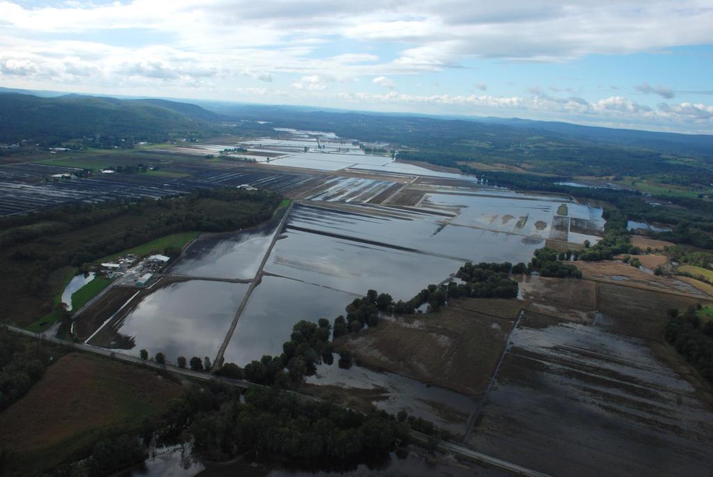
3 Location MIDDLETOWN NEWBURGH PROJECT

4 Location
5 Define the Problem Extremely flat topography Less than 25 feet of elevation drop in the main channel through the 12.5 mile Black Dirt region Farm fields supply produce to New York City Minimize time lost on fields

6 History Black Dirt What is it? Why is it significant? Drainage District 1930 s ACoE Project 1980 s ACoE Project
7 History Current Project Grant obtained to address flooding after Irene Created Committee of local farmers to administer Alternative Analysis Implementation of Priority Projects
8 Alternative Analysis Hydrology HEC-RAS Model Priority Projects
9 Hydrology Gage Station Data Wallkill River near Pellets Island Road Pochuck Creek near Newport Bridge Road Rutgers Creek near Carter Road Quaker Creek in Florida, NY Log Pearson Type III Frequency Analysis Hydrographs
10 Hydrology
11 Hydrology Peak Discharges (cfs) Event Gage Station Wallkill River Pochuck Creek Quaker Creek Rutgers Creek 2 Year 4,045 1, ,667 5 Year 5,466 1, , Year 6,473 2, , Year 7,488 2, , Year 8,882 3,105 1,005 4, Year 9,993 3,593 1,156 5, Year 12,811 4,901 1,547 7,640
12 Hydrology
13 Hydraulics HEC-RAS Army Corps of Engineers LIDAR Data Field Verification Existing Conditions Model (Baseline) Proposed Alternative Models
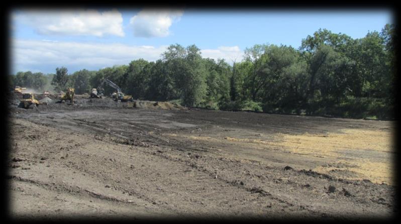
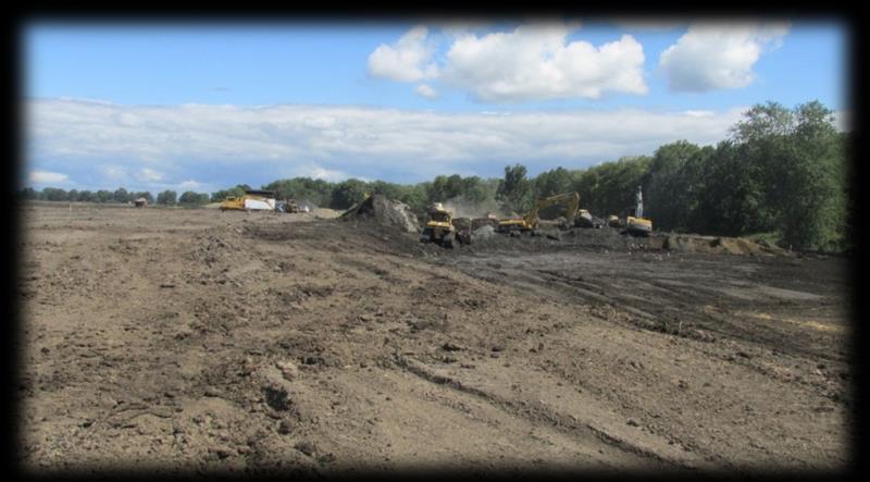
14 Hydraulics Over 20 Alternatives evaluated 3 Priority Projects Identified Pochuck Creek Rock Ledge Celery Avenue Rock Ledge Floodplain Bench Project
15 Hydraulics
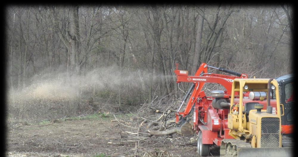
16 Floodplain Bench Project Objective: Add conveyance while restoring and preserving the natural character of the stream.

17 Floodplain Bench Project
18 Floodplain Bench Project Typical Section

19 Floodplain Bench Project Planting Plan 2 versus 4 trees
20 Floodplain Bench Project Benefits Reduce magnitude of flooding upstream Reduce duration of flooding upstream (particularly smaller events) Increased habitat along river
21 Floodplain Bench Project Construction Phase 1 Began first week in August Bench cut being completed this week Planting beginning this week Construction Photos


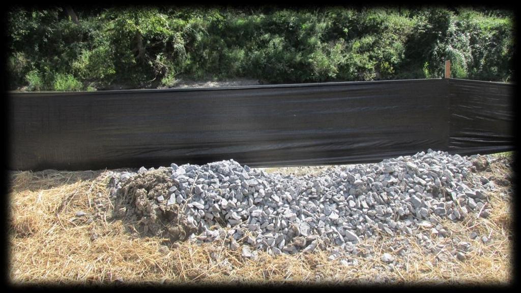
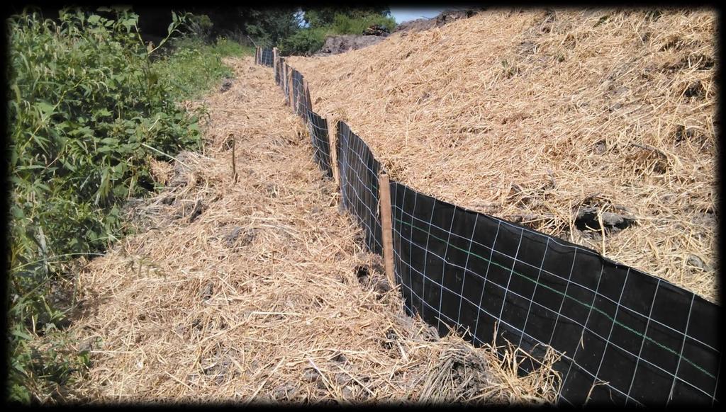
22 Tree cutting before March 31st

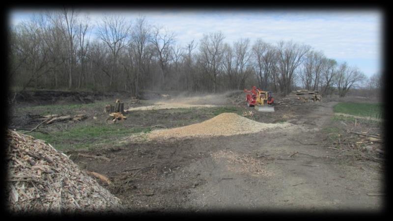
23 Chipping April 2016

24 Large work force with articulating end dumps large capacity but not kind to soil

25 Large work force with articulating end dumps large capacity but not kind to soil

26 Wet working conditions, stabilization as work proceeds

27 Challenging soil conditions

28 GPS controlled grading

29 Acute erosion and sediment control concerns

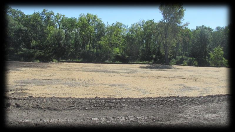
30 Access road


31 Project starts at Rutgers Creek/Wallkill River confluence

32 Soil from excavation used to improve adjacent farm fields according to grading plan

33 Farm field grading plan includes chisel plowing before and after new soil placement

34 Complex soil layering including sedimentary peat

35 Complex soil layering including sedimentary peat

36 60,000 CY ~ 3,750 triaxle trips

37 200 foot wide floodplain bench construction proceeds

38 Truck traffic requires constant repairs to access roads

39 I hate when that happens

40 I hate when that happens

41 More E&SC
42 More E&SC

43 Segregating soil material

44 Next time-flotation equipment

45 Dealing with trees we are trying to keep

46 Wet bench issues

47 Trees laid out for planting
48 Quiz 1. What statistical analysis was run to determine peak discharges?
49 Quiz 1. What statistical analysis was run to determine peak discharges? Log Pearson Type III
50 Quiz 2. How many gage stations were utilized in the analysis?
51 Quiz 2. How many gage stations were utilized in the analysis? Four Wallkill River near Pellets Island Road Pochuck Creek near Newport Bridge Road Rutgers Creek near Carter Road Quaker Creek in Florida, NY
52 Quiz 3. What were the benefits of the Floodplain Project?
53 Quiz 3. What were the benefits of the Floodplain Project? Reduce magnitude of flooding upstream Reduce duration of flooding upstream (Particularly smaller events) Increased habitat along river
54 Quiz 4. How many phases is the project being implemented in?

55 Quiz 4. How many phases is the project being implemented in? Three
56 Questions?
WARSAW WAL-MART EXPANSION FLOODPLAIN EVALUATION STUDY
 WARSAW WAL-MART EXPANSION FLOODPLAIN EVALUATION STUDY BERGMANN ASSOCIATES NOVEMBER 20, 2008 (revised June 8, 2009) TOWN OF WARSAW, WYOMING COUNTY, NEW YORK Memorandum To: Jack Buholtz, PE From: Kenneth
MEMORANDUM. September 10, 2018
 September 10, 2018 MEMORANDUM TO: Chad Bird, City of Decorah FROM: Larry Weber and Dan Gilles, Iowa Flood Center, IIHR Hydroscience & Engineering COPY TO: Dana Werner, St. Paul District Corps of Engineers,
STREAM BANK STABILIZATION THORPS MORTIMER RECREATION AREA Grandfather Ranger District SITE LOCATION & DRAINAGE AREA
 STREAM BANK STABILIZATION THORPS CREEK @ MORTIMER RECREATION AREA SITE LOCATION & DRAINAGE AREA SITE LOCATION Drainage Area = 1.14 sq. miles STREAM BANK STABILIZATION THORPS CREEK @ MORTIMER RECREATION
Presentation to Parks and Open Space Advisory. Committee September 22, 2016
 Flood Planning & Preliminary Design Services for South St. Vrain Creek Restoration at Hall Ranch Presentation to Parks and Open Space Advisory Prepared for: Boulder County, Colorado Committee September
NYC DEP s Approach to Flood Mitigation: The Local Flood Analysis (LFA) Process
 Process") NYC DEP s Approach to Flood Mitigation: The Local Flood Analysis (LFA) Process Milone & MacBroom, Inc. Jenabay Sezen, EIT Connecticut Association of Floodplain Managers October 25, 2016 Agenda Introduction
NYC DEP s Approach to Flood Mitigation: The Local Flood Analysis (LFA) Process Milone & MacBroom, Inc. Jenabay Sezen, EIT Connecticut Association of Floodplain Managers October 25, 2016 Agenda Introduction
Lincoln 270. City of Lincoln. Stormwater Management Plan. April 2, 2013
 Lincoln 270 City of Lincoln Stormwater Management Plan April 2, 2013 # 2005.48 Prepared By: Civil Engineering Solutions, Inc. 590 E Street Lincoln, Ca 95648 (916) 645 5700 1.0 Background: The project site
Washington County, Maryland Division of Public Works Policy Manual
 Washington County, Maryland Division of Public Works Policy Manual Subject: Downstream Drainage Easement Category: Land Development Engineering Number: 7-4.1 Date: June 1, 2009 (effective) PURPOSE: The
Climate Smart Communities Green Infrastructure Case Studies
 New York State Water Resources Institute Climate Smart Communities Green Infrastructure Case Studies Emily Vail Hudson River Estuary Program NYS Department of Environmental Conservation Cornell University
Stormwater Regulations & Considerations Morse Study Area. Pam Fortun, P.E. CFM Senior Stormwater Treatment Engineer Engineering Services Division
 Stormwater Regulations & Considerations Morse Study Area Pam Fortun, P.E. CFM Senior Stormwater Treatment Engineer Engineering Services Division Stormwater Regulations Development Considerations Floodplain
Santa Cruz River Master Plan. Presented to the Arizona Floodplain Management Association Spring Conference June 8-10, 2011
 Santa Cruz River Master Plan Presented to the Arizona Floodplain Management Association Spring Conference June 8-10, 2011 Introduction Who is FICO? 2 Project Team Kimley-Horn and Associates, Inc. River
Draft Rhode Island Stormwater Design and Installation Standards Manual
 Draft Rhode Island Stormwater Design and Installation Standards Manual Summary The May 2009 Public Review Draft version of the RI Stormwater Design and Installation Standards Manual consists of approximately
Farmers Investment Co. (FICO) Continental Farms
 Continental Farms") Farmers Investment Co. (FICO) Continental Farms Planning & Zoning Commission Study Session (River Master Plan) January 25, 2012 FICO Property 7,000 acres total area 6,000 acres in Town of Sahuarita 1,000
Farmers Investment Co. (FICO) Continental Farms Planning & Zoning Commission Study Session (River Master Plan) January 25, 2012 FICO Property 7,000 acres total area 6,000 acres in Town of Sahuarita 1,000
Impact of Storm Drains on Urbanized Alluvial Fan Flooding in Ventura County, California
 Impact of Storm Drains on Urbanized Alluvial Fan Flooding in Ventura County, California Presented to: FMA Annual 2015 Conference September 8-11, 2015 Presented by: Jim O Brien, Ph.D., P.E. Noemi Gonzalez,
Zoning Ordinance Chapter 10
 CHAPTER 10 - WASHES SECTION 10.0 GENERAL: A. The purpose of this Ordinance is to establish standards for development in or near Major and Minor Washes as defined in Appendix A Glossary of Terms and Definitions
Appendix E Preliminary Location Hydraulic Study
 Appendix E Prepared for: State of Alaska Department of Transportation and Public Facilities Prepared by: HDR Alaska, Inc. 2525 C Street, Suite 305 Anchorage, Alaska 99503 February 2014 This page intentionally
Existing Conditions and Environmental Consequences Floodplains
 3.9 Environmental Consequences 3.8 3.8.1 WHAT ARE FLOODPLAINS? are low-lying areas adjacent to rivers, streams, and other waterbodies that are susceptible to inundation (flooding) during rain events. These
River Corridor Overlay Zone (RCOZ) Article 5
 Article 5") River Corridor Overlay Zone (RCOZ) Article 5 The site is in one of two designated districts. The first is the CBD (central business district) River District, which recognizes the urban character and unique
River Corridor Overlay Zone (RCOZ) Article 5 The site is in one of two designated districts. The first is the CBD (central business district) River District, which recognizes the urban character and unique
Checklists. Project Name: Location: File Number: Date of Submittal: Reviewer: Date: Applicant: Contact Name: Phone Number:
 Applicant: Contact Name: Phone Number: Email: Project Name: Location: File Number: Date of Submittal: Reviewer: Date: Concept Plan Requirements: I. General Project Information 1. Address or parcel number
North Branch of Cypress Creek Ecological Restoration: A Comprehensive Approach to Stream Restoration
 North Branch of Cypress Creek Ecological Restoration: A Comprehensive Approach to Stream Restoration Rocky Powell Clear Creeks Consulting, LLC Keith D. Tate, P.E. BayLand Consultants & Designers, Inc.
4. Contractor (and subcontractors if applicable) certification statement(s)
 certification statement(s)") CHEMUNG COUNTY STORMWATER COALITION STORMWATER POLLUTION PREVENTION PLAN (SWPPP) SUBMITTAL CHECKLIST GENERAL INFORMATION: 1. Owner/Operator name, legal address, phone number 2. Copy of signed Notice of
CHEMUNG COUNTY STORMWATER COALITION STORMWATER POLLUTION PREVENTION PLAN (SWPPP) SUBMITTAL CHECKLIST GENERAL INFORMATION: 1. Owner/Operator name, legal address, phone number 2. Copy of signed Notice of
Is a Riparian Restoration Still Viable After 100-year Storm Events Alter the Original Design?
 Is a Riparian Restoration Still Viable After 100-year Storm Events Alter the Original Design? Sarah Spear Cooke, Ph.D. Seattle, Washington Presentation Outline Introduction The site pre-restoration Restoration
Post Construction BMPs
 Post Construction BMPs Why are Post Construction BMPs important? With increased development brings the increase of impervious cover Parking lots, rooftops, driveways Storm water runoff volume increases
Imperviousness & Runoff
 North Texas Alternative Futures Imperviousness & Runoff A key indicator for comparing alternative future scenarios This powerpoint presents: What is this key indicator? How do the alternative future scenarios
Stream Corridor Management Plan
 Stream Corridor Management Plan A unified and comprehensive approach to protecting, restoring and managing the Upper Delaware River Graydon Dutcher Delaware County Soil and Water Conservation District
Stormwater Pollution Prevention Plan Oneonta Heights Oneonta, NY TABLE OF CONTENTS PAGE
 Oneonta Heights Oneonta, NY TABLE OF CONTENTS PAGE I. INTRODUCTION... 2 II. EXISTING CONDITIONS... 3 A. Topography/ Drainage... 3 B. Soils... 3 C. Wetlands... 3 D. Floodplain... 3 E. NYSDEC Environmental
SECTION 5: REACH RECOMMENDATIONS/MAPS
 SECTION 5: REACH RECOMMENDATIONS/MAPS This section describes areas of concern and provides specific recommendations for each project reach. Locations of stormwater drains were from GIS coverage supplied
Biological Constraints Survey for 5th Street Drainage Improvements. City of Highland, San Bernardino County, California
 for 5th Street Drainage Improvements City of Highland, San Bernardino County, California August 2010 Prepared for City of Highland 27215 Baseline Highland, CA 92346 Prepared by HDR Engineering, Inc. 8690
Caledon Villas Corp. c/o Mr. John Spina 55 Blue Willow Drive Woodbridge, ON L4L 9E8 May 14, Floodplain Characteristics, Old Church Road
 Caledon Villas Corp. c/o Mr. John Spina 55 Blue Willow Drive Woodbridge, ON L4L 9E8 May 14, 2013 Re: Floodplain Characteristics, Old Church Road This letter serves to confirm that I, Linda Sober, have
water resource specialists
 Vaughn Collins, PE, CFM, Northwest Hydraulic Consultants Brad Livingston, Oregon Department of Transportation Melissa Reich, North Coast Land Conservancy Location Necanicum River 75 sq mi watershed Active
Shelbyville, KY Stormwater Best Management Practices. Section 2 EROSION PREVENTION AND SEDIMENT CONTROL PLAN
 Section 2 EROSION PREVENTION AND SEDIMENT CONTROL PLAN 2.1 Requirements The City of Shelbyville, KY will require an Erosion Prevention and Sediment Control (EPSC) Plan for most types of development construction.
Alternatives Analysis Summary Memorandum
 F 16253 Swingley Ridge Rd, Suite 100, St. Louis, MO 63017 636-777-3000 P 314.432.5812 F Alternatives Analysis Summary Memorandum To: City of Creve Coeur, Missouri By: Mark Meyer, PE Date: 09-25-2013 Re:
Conservation in South Jersey Being Creative with Restoration
 Conservation in South Jersey Being Creative with Restoration Stewardship on a Shoestring: Public Land Management in Fiscally Constrained Times November, 30, 2011 Conservation and Restoration for Open Space
Construction Progress Report
 Report Date: 4/8/2017 Subject: Construction Week 2 70% Complete Project: Sunset Pond EWP Stream Reclamation, Fourmile Creek, Boulder County, CO Report By: TJ Burr, Civil Engineer/Stream Restoration Specialist,
Chapter 1 GENERAL SOUTH DAKOTA DRAINAGE MANUAL
 Chapter 1 GENERAL SOUTH DAKOTA DRAINAGE MANUAL October 2011 Table of Contents Section Page 1.1 INTRODUCTION...1-1 1.2 BASIC APPROACH...1-2 1.3 FUNCTIONAL RESPONSIBILITIES...1-3 1.3.1 Office of Road Design...1-3
TENNESSEE GAS PIPELINE COMPANY, L.L.C.
 TENNESSEE GAS PIPELINE COMPANY, L.L.C. HYDROLOGIC AND HYDRAULIC CALCULATIONS FOR ACCESS ROADS ALONG THE CONNECTICUT PIPELINE EXPANSION PROJECT CONNECTICUT LOOP Submitted by: Tennessee Gas Pipeline Company,
Modeling Cumulative LID Features for Floodplain Impacts in an Urban Watershed in Houston, TX
 Modeling Cumulative LID Features for Floodplain Impacts in an Urban Watershed in Houston, TX Christina Hughes, Phil Bedient cmhughes@rice.edu May 2, 2014 1 Modeling Cumulative LID Features for Floodplain
Tentatively Selected Plan within Harlem River, East River and Western Long Island Sound Planning Region. First Level Costs. Federal Non-Federal Total
 HARLEM RIVER, EAST RIVER AND WESTERN LONG ISLAND SOUND PLANNING REGION Flushing Bay and Creek Ecosystem Restoration Source Feasibility Study Background Study Resolution (1994), Reconnaissance Report (1996),
When planning stormwater management facilities, the following principles shall be applied where possible.
 2.0 Principles When planning stormwater management facilities, the following principles shall be applied where possible. 2.0.1 Drainage is a regional phenomenon that does not respect the boundaries between
Colorado Watershed Protection Fund - Project Grant Application Fountain Creek Restoration Shryver Park Reach Including Shryver Pond
 Fountain Creek - Manitou Springs, CO Shryver Park Reach and Pond Restoration Project Submitted by: The Fountain Creek Restoration Committee & The Pikes Peak Community Foundation April 28, 2008 FCRC Page
MARBLE RIVER WIND POWER PROJECT Agricultural Protection Measures
 MARBLE RIVER WIND POWER PROJECT Siting Considerations 1. Locate access roads and, to the extent allowed by local laws, wetlands and topography, individual wind turbines and other structures along field
Lower Don River West Remedial Flood Protection Project TABLE OF CONTENTS. Page. Executive Summary
 TABLE OF CONTENTS Page Executive Summary 1.0 INTRODUCTION...1-1 1.1 Purpose of the Undertaking...1-1 1.2 Study Area Description...1-1 1.3 Description of the Undertaking...1-1 1.4 Rationale for the Undertaking...1-2
Advance Engineering & Surveying PLLC
 Advance Engineering & Surveying, PLLC Consulting in: Civil & Environmental Engineering Land Surveying Land Development 11 Herbert Drive Phone: (518) 698-3772 Latham, N.Y. 12110 Email:ncostape@gmail.com
River Mile 10.9 Removal Action Overview
 River Mile 10.9 Removal Action Overview November 13, 2014 CAG Meeting Modified from CPG s RM10.9 Removal Action Final Design Report dated Nov. 2013 1 River Mile 10.9 Removal Action Activities Dredging:
Restoring Floodplain Capacity and Hyporheic Function in an Urban Setting Thornton Confluence and Kingfisher Projects Mike (Rocky) Hrachovec, P.E.
 Hrachovec, P.E.") Restoring Floodplain Capacity and Hyporheic Function in an Urban Setting Thornton Confluence and Kingfisher Projects Mike (Rocky) Hrachovec, P.E. Project Locations: Historic Map of Thornton Creek orth
Restoring Floodplain Capacity and Hyporheic Function in an Urban Setting Thornton Confluence and Kingfisher Projects Mike (Rocky) Hrachovec, P.E. Project Locations: Historic Map of Thornton Creek orth
Poisoned Park? How Exide s Lead Contamination Risks Frisco s Grand Park
 Frisco City Hall has big plans to transform Stewart Creek into a Grand Park with lots of water features for kids to play in. Poisoned Park? How Exide s Lead Contamination Risks Frisco s Grand Park But
Fisher Slough Tidal Marsh Restoration Project Scaling Down the Restoration Planning & Analysis Framework to Evaluate Project Alternatives
 Fisher Slough Tidal Marsh Restoration Project Scaling Down the Restoration Planning & Analysis Framework to Evaluate Project Alternatives Project Sponsor/Partners The Nature Conservancy Dike District #3
ENBRIDGE GAS DISTRIBUTION INC. Proposed Relocation for Ninth Line, Markham and Whitchurch-Stouffville. Environmental Screening Report
 Page 1 of 18 ENBRIDGE GAS DISTRIBUTION INC. Proposed Relocation for Ninth Line, Markham and Whitchurch-Stouffville Environmental Screening Report July 2011 Page 2 of 18 Table of Contents 1.0 INTRODUCTION
Stream Restoration: Working with Nature?
 Stream Restoration: Working with Nature? Greg Jennings, PhD, PE jenningsenv@gmail.com Ecosystem Restoration activities that initiate or accelerate the recovery of ecosystem health, integrity, and sustainability
Stream Restoration: Working with Nature? Greg Jennings, PhD, PE
 Stream Restoration: Working with Nature? Greg Jennings, PhD, PE jenningsenv@gmail.com Ecosystem Restoration activities that initiate or accelerate the recovery of ecosystem health, integrity, and sustainability
Public Open House. Welcome! Presentation at 5:15 p.m. Please sign-in at the registration table
 Public Open House Welcome! Presentation at 5:15 p.m. Please sign-in at the registration table The Grand Avenue Extension Location and Environmental Study will determine the location of the extension of
Pike River Restoration Adaptive Design: Restoring Structure and Function in an Urban Floodplain - from cabbages to cordgrass
 Pike River Restoration Adaptive Design: Restoring Structure and Function in an Urban Floodplain - from cabbages to cordgrass Alice Thompson, PWS & Heather Patti, PWS Pike River Re-imaginedfrom Cabbage
Farmers Investment Co. (FICO) Sahuarita Farms Specific Plan & Minor General Plan Amendment Community Meeting July 1, 2014
 Sahuarita Farms Specific Plan & Minor General Plan Amendment Community Meeting July 1, 2014") Farmers Investment Co. (FICO) Sahuarita Farms Specific Plan & Minor General Plan Amendment Community Meeting July 1, 2014 FICO / Property Overview FICO Properties 7,000 Acres Total 5,900 Acres in Town
Farmers Investment Co. (FICO) Sahuarita Farms Specific Plan & Minor General Plan Amendment Community Meeting July 1, 2014 FICO / Property Overview FICO Properties 7,000 Acres Total 5,900 Acres in Town
Design Guidelines for the Enhancement and Creation of Estuarine Habitats in the Middle Reaches of the Lower Columbia River
 Design Guidelines for the Enhancement and Creation of Estuarine Habitats in the Middle Reaches of the Lower Columbia River Astoria, May 16, 2012 1 Outline I. Nature of Project/Background II. Approach to
The Napa River Flood Protection Project
 The Napa River Flood Protection Project Creating Flood Protection and Restoring Geomorphic and Biological Processes Jeremy Sarrow, Napa County Flood Control & Water Conservation District June 2, 2014.
Problem Understanding
 Introduction...2-1 Previous Data and Mapping...2-2 Known Problem Areas...2-3 Resident Survey.2-3 Introduction The Village of Downers Grove stormwater system includes storm sewers, streams, wetlands, roadway
Using the Past to Understand the Present Emerging Lessons for Environmental Planning in the Santa Clara Valley
 Using the Past to Understand the Present -- -- -- Emerging Lessons for Environmental Planning in the Santa Clara Valley Robin Grossinger Director of the Historical Ecology Program San Francisco Estuary
City of Shady Cove Riparian Ordinance Ordinance XXX
 1 Updated October 8, 2015 City of Shady Cove Riparian Ordinance Ordinance XXX This language is to be located in Chapter 155 of the Shady Cove Code of Ordinances. This will affect property inside city limits,
5. LOW IMPACT DEVELOPMENT DESIGN STANDARDS
 5. LOW IMPACT DEVELOPMENT DESIGN STANDARDS Low Impact Development (LID) requires a shift in stormwater management away from conveying runoff to a small number of downstream points through hydraulically
Wetland Restoration In Altered Landscapes
 Wetland Restoration In Altered Landscapes Mike McClure, Wetland Service Biologist, MO Dept. of Conservation Wetland Restoration In Altered Landscapes Do s, Don ts and Things To Think About Assessing the
Why a new Food & Farm Ordinance?
 Growing for Kane Why a new Food & Farm Ordinance? 1. Growing obesity issue 64% of Kane adults are overweight or obese 2. Low rates of fruit & vegetable consumption Healthy diets include more fruits & veggies.
Arroyo Grande Creek Flood Control Channel Vegetation Management: A Photo Series
 Arroyo Grande Creek Flood Control Channel Vegetation Management: A Photo Series The Way It Was For several decades, all vegetation growth was discouraged in the AG Creek flood control channel, as shown
CITY COUNCIL AGENDA REPORT
 CITY COUNCIL AGENDA REPORT Subject: DESIGNATED FLOOD LINE CARROT CREEK Recommendation(s) That Administration bring forward a Land Use Bylaw amendment in October 2014 establishing the Designated Flood Line
Northern Branch Corridor DEIS December 2011
 16 Floodplains 161 Chapter Overview 1611 Introduction The flowing chapter identifies floodplains found within the Northern Branch Corridor in accordance with Executive Order 11988, Floodplain Management
7th Avenue Creek Master Plan Development Project. City of St. Charles, IL. IAFSM CONFERENCE March 14, 2018 MARKET
 7th Avenue Creek Master Plan Development Project MARKET City of St. Charles, IL IAFSM CONFERENCE March 14, 2018 7 TH AVENUE CREEK PROJECT AREA 2 2008 RAIN EVENT 3 RESIDENTIAL STRUCTURE FLOODING COMMERCIAL
6Natural. Environment Development Permit Guidelines
 6Natural Bylaw 2600-2016, being "Official Community Plan Bylaw, 2016" Schedule "A" CITY OF ABBOTSFORD OFFICIAL COMMUNITY PLAN Environment Development Permit Guidelines Part V - 6-1 Area Subdivision or
ST. MARY S SOIL CONSERVATION DISTRICT (SMSCD) AND DPW&T CONCEPT EROSION AND SEDIMENT CONTROL AND STORMWATER MANAGEMENT GUIDELINES AND CHECKLIST
 AND DPW&T CONCEPT EROSION AND SEDIMENT CONTROL AND STORMWATER MANAGEMENT GUIDELINES AND CHECKLIST") St. Mary s Soil Conservation District 26737 Radio Station Way, Suite B Leonardtown, MD 20650 Phone: 301-475-8402 ext. 3 Fax: 301-475-8391 www.stmarysscd.com St. Mary s County Government Department of Public
St. Mary s Soil Conservation District 26737 Radio Station Way, Suite B Leonardtown, MD 20650 Phone: 301-475-8402 ext. 3 Fax: 301-475-8391 www.stmarysscd.com St. Mary s County Government Department of Public
Bioretention cell schematic key
 Bioretention Cells Bioretention cell schematic key 1 3 Hardwood mulch 2 Curb cut 3 18-30 Modified soil 4 Stone aggregate choker layer 5 Stone aggregate base layer 6 Subdrain 7 Undisturbed soil 8 Overflow/Cleanout
STREAM ALTERATION PRACTICES
 STREAM ALTERATION PRACTICES Stream Diversion Channel SDC DEFINITION A temporary channel constructed to convey stream flow around in-stream construction. PURPOSE Stream diversion channels are used to allow
Monica Smith, PE President Robinson Engineering Company
 Monica Smith, PE President Robinson Engineering Company Owner Robinson Engineering Masters Degree in Water Resource Management for Colorado State University The Dry Run Creek project got me interested
Kootenai River Habitat Restoration Program June 18, 2018 Kootenai Valley Resource Initiative Update
 Kootenai River Habitat Restoration Program June 18, 2018 Kootenai Valley Resource Initiative Update Kootenai River Habitat Restoration Program Multi-year habitat restoration program Restoration treatments
3.1 Survey Monument Preservation Guidelines for New and Reconstruction Projects. B. After construction and prior to recording Notice of Completion:
 3.0 SURVEY 3.1 Survey Monument Preservation Guidelines for New and Reconstruction Projects A. Prior to construction: 1. Public survey records are to be researched for the location of all possible survey
New Development Stormwater Guidelines
 New Development Stormwater Guidelines CITY OF MOUNTLAKE TERRACE Table of Contents Introduction... 2 Ecology s Minimum Requirements for stormwater management... 2 Description of the 9 Minimum Requirements...
Old Mill Community Association Bioretention Facility
 Project Overview This project will install a bioretention facility in a community recreation area owned by the Old Mill Community Association, Inc. Drainage from the area is currently unmanaged and has
Stormwater Retrofitting: The Art of Opportunity. Presented by the Center for Watershed Protection
 Stormwater Retrofitting: The Art of Opportunity Presented by the Center for Watershed Protection What Are Stormwater Retrofits? Retrofits are stormwater management measures inserted in an urban or ultra-urban
WETLAND SOD u Bare Root Wetland Plants u Deep Rooted Willows u Coir Logs u Native Trees & Shrubs u Habitat Islands u Custom Growing
 WETLAND SOD u Bare Root Wetland Plants u Deep Rooted Willows u Coir Logs u Native Trees & Shrubs u Habitat Islands u Custom Growing 2009 PROJECT HIGHLIGHTS The following 10 projects highlight the interesting
Your town s subdivision or land use ordinance standards should reference the following street standards, for example:
 Your town s subdivision or land use ordinance standards should reference the following street standards, for example: Streets shall be designed to move traffic safely and in a way that minimizes environmental
CHECKLIST FOR PHASE II DRAINAGE REPORT
 I. COVER SHEET CHECKLIST FOR PHASE II DRAINAGE REPORT A. Name of Project B. Address C. Owner D. Developer E. Engineer F. Submittal date and revision dates as applicable II. GENERAL LOCATION AND DESCRIPTION
NEW YORK STATE WATER RESOURCES INSTITUTE Department of Biological and Environmental Engineering
 NEW YORK STATE WATER RESOURCES INSTITUTE Department of Biological and Environmental Engineering 230 Riley-Robb Hall, Cornell University Tel: (607) 254-7163 Ithaca, NY 14853-5701 Fax: (607) 255-4449 http://wri.cals.cornell.edu
Working Group Meeting
 April 4,, 2017 Parks Operations Bldg Working Group Meeting Arts Districts Overview Stormwater/RPA/Stream Considerations First Principles Agenda 7:00pm 7:05pm 7:10pm 7:40pm 8:30pm 9:40pm 9:45pm Welcome
Urban Stormwater Retrofit Program Highlights
 Urban Stormwater Retrofit Program Highlights Delaware Estuary Environmental Summit 2007 Prepared and Presented by: Liz Feinberg Project Funding: William Penn Foundation PA Coastal Zone Management Program
MANUAL OF DESIGN, INSTALLATION, AND MAINTENANCE REQUIREMENTS FOR STORMWATER MANAGEMENT PLANS
 MANUAL OF DESIGN, INSTALLATION, AND MAINTENANCE REQUIREMENTS FOR STORMWATER MANAGEMENT PLANS May 2007 SECTION 1 Responsibility of Applicant TABLE OF CONTENTS A. Stormwater Management Plan Required Information
3/7/2013. Compliance & Sustainability
 Overview www.kieser associates.com Celebrating 20 Years of Excellence in Environmental Science & Engineering WMU Arcadia Creek Stormwater Treatment and Floodplain Enhancement Project DEQ #2008 0018 and
City of Norfolk Coastal Flood Mitigation Program. March 13, 2013
 City of Norfolk Coastal Flood Mitigation Program March 13, 2013 Topics Brief overview of Norfolk s Coastal Flood Program Data-driven analysis and decision making City-wide vulnerability, project concepts,
This program has been registered with LA CES by the New York Upstate This program has been registered with LA CES by the New York Upstate Chapter of
 This program has been registered with LA CES by the New York Upstate This program has been registered with LA CES by the New York Upstate Chapter of the American Society of Landscape Architects. Chapter
City of Elmhurst. Comprehensive Flood Plan. City of Elmhurst. City Council Meeting September 15, 2014
 City of Elmhurst City of Elmhurst Comprehensive Flood Plan City Council Meeting September 15, 2014 City of Elmhurst Presentation Overview Study Background Study Methodology Analysis of Three Additional
NEWPORT NEWS/WILLIAMSBURG INTERNATIONAL AIRPORT DESIGN AND SUSTAINABILTY GUIDELINES
 NEWPORT NEWS/WILLIAMSBURG INTERNATIONAL AIRPORT DESIGN AND SUSTAINABILTY GUIDELINES VERSION 1.6 August 2011 PREPARED BY: 900 Bland Boulevard Suite G Newport News, Virginia 23602 DESIGN AND SUSTAINABILITY
Municipal Stormwater Management: Does Your Town Need More than the Minimum?
 Municipal Stormwater Management: Does Your Town Need More than the Minimum? ANJEC Congress Friday, October 9, 2015 www.anjec.org 973 539 7547 The existence of a regulation indicates a failure of design.
2014 HDR 2014 Architecture, HDR, Inc., all all rights reserved. reserved.
 2014 HDR 2014 Architecture, HDR, Inc., all all rights reserved. reserved. Uplift of a Wet Weather Stream: Satisfying Regulatory Requirements Agawela Drive Stream Project Chattanooga, TN 2014 HDR, Inc.,
RFP DRAINAGE OUTFALL DESIGN AND PERMITTING. Mandatory Meeting for Proposers August 15, 2015
 RFP 2018-02 DRAINAGE OUTFALL DESIGN AND PERMITTING Mandatory Meeting for Proposers August 15, 2015 IMPORTANT DATES August 15 th, 2:00pm August 17 th, 5:00pm August 22 nd, 5:00pm September 5 th, 2:00pm
BASS PONDS, MARSH, & WETLAND HABITAT RESTORATION PROJECT
 FACT SHEET BASS PONDS, MARSH, & WETLAND HABITAT RESTORATION PROJECT MINNESOTA VALLEY NATIONAL WILDLIFE REFUGE, MINNESOTA ENVIRONMENTAL MANAGEMENT PROGRAM LOCATION Three areas located on the Minnesota Valley
TOWN OF BETHLEHEM OPEN SPACE CONSERVATION PLAN PUBLIC MEETING: OCTOBER 12, 2017
 TOWN OF BETHLEHEM OPEN SPACE CONSERVATION PLAN PUBLIC MEETING: OCTOBER 12, 2017 Welcome and Agenda 6:00 6:45: Open House, Part One 6:45 7:15: Presentation and Questions 7:15 8:00: Open House, Part Two
Chapter 4 - Preparation of Stormwater Site Plans
 Chapter 4 - Preparation of Stormwater Site Plans The Stormwater Site Plan is the comprehensive report containing all of the technical information and analysis necessary for the City to evaluate a proposed
Welcome to the Landscape Design Association Winter Workshop
 Welcome to the Landscape Design Association Winter Workshop The Wonderful World of Grading & Drainage? Presented by Paul Laiblin - Design Production Manager Scott Byron & Co., Inc. The Wonderful World
Jill Stachura STORMWATER BMP AND STREAM RESTORATION IN A CITY PARK. October 2013 Southeast Stormwater Association Annual Conference, Charlotte, NC
 Jill Stachura STORMWATER BMP AND STREAM RESTORATION IN A CITY PARK October 2013 Southeast Stormwater Association Annual Conference, Charlotte, NC Project Location Gwinnett County, GA: Population: 825,000
Green Infrastructure
 New York State Water Resources Institute Green Infrastructure in the Hudson Valley May 17, 2011 Emily Vail Hudson River Estuary Program New York State Department of Environmental Conservation In cooperation
Retrofitting Low Impact Development (LID) for Stormwater at Sacramento State. City of Sacramento Sacramento State Facilities Management
 for Stormwater at Sacramento State. City of Sacramento Sacramento State Facilities Management") Retrofitting Low Impact Development (LID) for Stormwater at Sacramento State City of Sacramento Sacramento State Facilities Management Project Background Campus Storm Drain System Drain Inlet - Campus
Retrofitting Low Impact Development (LID) for Stormwater at Sacramento State City of Sacramento Sacramento State Facilities Management Project Background Campus Storm Drain System Drain Inlet - Campus
Chapter 1: General Program Information
 Chapter 1: General Program Information 1.1 Introduction The Montgomery County Stormwater Management Resolution (#03-1-5) was adopted by the County Board of Commissioners on January 22, 2003. The purpose
January 2016 Public Works Project of the Year. Environment. Lyon Creek Flood Mitigation. City of Lake Forest Park, Washington
 January 2016 Public Works Project of the Year Environment Lyon Creek Flood Mitigation City of Lake Forest Park, Washington Overview Completion of the Lyon Creek Flood Mitigation Project eliminated recurrent
Improving Communities Through the Arroyo Seco Sustainability Campaign and Watershed Assessment
 Improving Communities Through the Arroyo Seco Sustainability Campaign and Watershed Assessment Arroyo Seco Headwaters in the San Gabriel Mountains Major tributary to the Los Angeles River 44 square mile
Understanding Drainage Options What s Feasible and Legal. February 2019
 Understanding Drainage Options What s Feasible and Legal February 2019 Outline for the Presentation Do you need a permit? Does common law apply? Does local government approve it? Will my neighbor allow