WARSAW WAL-MART EXPANSION FLOODPLAIN EVALUATION STUDY
|
|
|
- Gertrude Kelley
- 5 years ago
- Views:
Transcription
1
2 WARSAW WAL-MART EXPANSION FLOODPLAIN EVALUATION STUDY BERGMANN ASSOCIATES NOVEMBER 20, 2008 (revised June 8, 2009) TOWN OF WARSAW, WYOMING COUNTY, NEW YORK
3 Memorandum To: Jack Buholtz, PE From: Kenneth Avery, PE, CFM, D. WRE Date: November 20, 2008 (revised June 8, 2009) Re: Floodplain Evaluation Warsaw Wal-Mart Introduction This memorandum summarizes the results of a floodplain evaluation for the Warsaw, NY Wal-Mart. An expansion of this existing 5.35 acre facility has been investigated, and floodplain study requirements have been issued by NYSDEC (letter dated April 5, 2007 from R. Anderson to D. DiMatteo). This floodplain evaluation was performed to determine if either the existing or proposed facility encroaches on the Oatka Creek 100-year floodplain, and if so, does the encroachment exceed the maximum allowable 1.0 feet increase allowed under the National Flood Insurance Program (NFIP). Oatka Creek flows along the northwest side of the Warsaw Wal-Mart site. The location of the 100-yr floodplain at this site is shown in the effective Flood Insurance Study (FIS) for the Town of Warsaw, New York as an unnumbered Zone A. Unnumbered Zone A areas show the approximate 100-year flood limits but have not been studied using detailed hydrologic and hydraulic methods. The Federal Emergency Management Agency (FEMA) and the Town of Warsaw Zoning Code require that proposed development in unnumbered Zone A areas consisting of more than 50 lots or 5 acres include base flood (100-year) elevation data. Thus, a detailed study of the existing and proposed development is required to determine if the proposed construction activity would encroach on the floodplain. The Buffalo District USACE is conducting detailed HEC-HMS and HEC-RAS model studies of the Oatka Creek in the Town and Village of Warsaw. Preliminary versions of both of these models were provided to Bergmann Associates by the Corps. Although the models do not represent the effective FIS, once completed, the results of the HEC-HMS and HEC-RAS model studies will provide a new Zone AE (detailed study) in the project area. Preliminary floodplain mapping, created by the Buffalo District USACE, have been attached. To begin, we compared the existing drainage areas and hydrology. The Village of Warsaw, NY, located approximately 1.9 miles upstream of the Wal-Mart site, includes an effective, detailed FIS of Oatka Creek. The drainage areas calculated in the USACE HEC-HMS model for the Oatka Creek were checked against corresponding values that were reported in the detailed study to verify reliability. This check is summarized in Table 1. The minor difference in the basin delineation and site location could cause the variation that is seen between the reported and calculated drainage area values. The variation between the FIS and the HMS is less than 2% at comparable locations. The values from the HMS model were used in the analysis process because they were considered to be the most current. Table 1: Drainage Area Comparison (Sq. Mi.) Village of Warsaw, Location Effective FIS Study HMS Model USGS Gage Old Buffalo Road Bridge (1) Wal-Mart Site N/A (1) The Old Buffalo Road Bridge is located at the downstream limit of the Village of Warsaw, which is also the downstream limit of the effective FIS study. Phone: Fax: First Federal Plaza / 28 East Main Street / Rochester, New York Architects / Engineers / Planners
4 Memorandum Hydrology Bergmann Associates performed independent peak discharge calculations using statistical analyses of the USGS gage records and USGS regression equations as a check of the HMS and FIS peak flow calculations. The procedure for statistically analyzing the USGS gage records near the Wal-Mart site is published in Bulletin #17B, Guidelines For Determining Flood Flow Frequency. The procedure for adjusting the statistical analyses for the ungaged sites and for performing the USGS regression equations is published in Magnitude and Frequency of Floods in New York: Scientific Investigation Report The comparison of the FIS data with the results of the HEC-HMS model, log-pearson Type III analysis, and the Region 6 Regression Equation is summarized in Table 2: Village of Warsaw Effective FIS Table 2: 100-Yr Flow Rate Comparison (cfs) HMS Model Phone: Fax: First Federal Plaza / 28 East Main Street / Rochester, New York Architects / Engineers / Planners Region 6 Regression Equation Weighted average of Regression and Log-Pearson III Location Log-Pearson III Gaging Station (3) 4990 (5) 4490 (3)(6) Old Buffalo Road Bridge (1)(3)(4) 5430 (5) 4990 (3)(6) Wal-Mart Site 3770 (1)(2) (1)(3)(4) 6230 (5) 5990 (3)(6) 1) Value projected from another location via the drainage area adjustment equation, shown below: Q (100@(2)) Q (100@(1)) A (@(1)) A (@(2)) X Q (100@(2)) = Q (100@(1)) * (A (@(2)) / A (@(1)) ) X, where is the flow rate at a downstream location, is the flow rate at a upstream location, is the drainage area of the upstream location, is the drainage area of the downstream location, and is a constant of the drainage basin, in this case 0.9 (determined from USACE Genesee River Basin study) 2) The drainage areas, used in this projection, are from the HMS model at the Old Buffalo Road Bridge and the Wal-Mart Site. 3) Value based on a Log-Pearson Type III Distribution of annual peak flow data from Gaging Station between 1964 and ) The drainage areas, used in this projection, are from the HMS model at the Gaging Station and the projected site. 5) The drainage areas, used in this calculation, are from the HMS model at the corresponding site. 6) The drainage areas, used in this calculation, are from the HMS model at the Gaging Station and the corresponding site. The values under Village of Warsaw Effective FIS at the Gaging Station and the Old Buffalo Road Bridge were obtained from the Village of Warsaw, NY FIS study. The third value under Effective FIS, for the Wal-Mart site, was obtained through the use of the drainage area adjustment equation. The drainage areas from the HEC-HMS model at the Old Buffalo Road Bridge and Wal-Mart site were used in this calculation. The three values under HMS Model were obtained by reviewing the output from the HEC-HMS model. The HEC-HMS model, developed by the Buffalo Distric USACE, is the most current source of data. The first value under Log-Pearson III is the value that was obtained by performing a Log-Pearson Type III Distribution of the annual peak flow rate data for Gaging Station Gaging Station is located in the Village of Warsaw and contains annual peak flow rates from 1964 to The Log-Pearson III Distribution was performed in accordance with the procedure published in Bulletin #17B of Guidelines For Determining Flood Flow Frequency. The second and third values under Log-Pearson III are values that have been projected from the Log-Pearson III value at the Gaging Station with the drainage area adjustment equation and drainage areas from the HEC-HMS
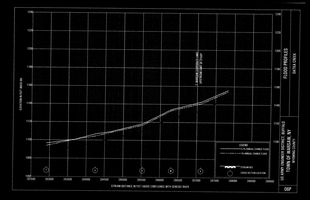
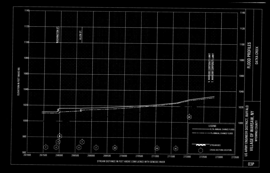
5 Memorandum model. The values under Region 6 Regression Equation calculated with the Region 6 regression equation, basin characteristics at the Gaging Station, and drainage areas for the respective sites. The Region 6 regression equation and basin characteristics at the Gaging Station were obtained from Magnitude and Frequency of Floods in New York. The basin characteristics were assumed to be constant between the Gage Station and the Wal-Mart site. The respective drainage areas were obtained from the HMS model. The values under the Weighted Average of Regression and Log-Pearson III were calculated according to the procedure published in Magnitude and Frequency of Floods in New York. Respective drainage areas from the HMS model and the results of the Log-Pearson Type III Distribution of Gaging Station data were used to perform these calculations After comparing the results of HEC-HMS model with the USGS Regression Equations and Log-Pearson III gage analysis, we concur that the HMS model provides is a reasonable representation of the hydrology. As a result, we used 5780 cfs as the 100-year discharge rate of Oatka Creek at the Wal-Mart site. Hydraulics Modifications were made to the HEC-RAS stream cross sections to match the topography that was obtained from a detailed survey of the Wal-Mart site performed by Bergmann Associates. The modified stream cross sections and the elevation of the floodplain can be seen in Figures 1 through 4. The elevation of the floodplain at the site can be seen in the Table 3. Figure 5 illustrates how the Oatka Creek Floodplain relates to the proposed Wal-Mart site. Both the FIS and survey of the Wal-Mart site are on NGVD 1929 datum. The new HEC-RAS work performed by the USACE is on the North American Vertical Datum 1988 (NAVD 88). The HEC-RAS output has been converted to the NGVD 1929 in Table 3 for comparative purposes. Table 3: Floodplain Elevation at the Wal-Mart Site Location River Station Flow Rate Floodplain Elevation From HEC-RAS Lowest Grading Elevation (cfs) (NGVD 1929) (1) (NGVD 1929) South Side of the Site South Side of the Wal-Mart Building North Side of the Wal-Mart Building North Side of the Site ) The NGVD 1929 datum is approximately 0.48 ft above the NAVD 88 datum at this location The floor elevation of the existing and proposed Wal-Mart is approximately 993. The extent of the grading around the proposed stormwater management basin, parking area and truck turn-around areas is currently slated to end at an elevation of 975, at the lowest extreme. The Oatka Creek floodplain will not be affect by the fill at this site because all the proposed grading will occur above the 100-year flood elevation. Phone: Fax: First Federal Plaza / 28 East Main Street / Rochester, New York Architects / Engineers / Planners
 Proposed Limits of Grading Figure 1: Proposed Cross Section at the South Side of the Site Proposed Wal-Mart Building Proposed Limits of Grading 100-yr Water Surface Elevation (El 973.")
6 Memorandum 100-yr Water Surface Elevation (El ) Proposed Limits of Grading Figure 1: Proposed Cross Section at the South Side of the Site Proposed Wal-Mart Building Proposed Limits of Grading 100-yr Water Surface Elevation (El ) Figure 2: Proposed Cross Section at the South Side of the Wal-Mart Building Phone: Fax: First Federal Plaza / 28 East Main Street / Rochester, New York Architects / Engineers / Planners
 Figure 3: Proposed Cross Section at the North Side of the Wal-Mart Building Proposed Limits of Grading 100-yr")

7 Memorandum Proposed Parking Lot Proposed Limits of Grading 100-yr Water Surface Elevation (El ) Figure 3: Proposed Cross Section at the North Side of the Wal-Mart Building Proposed Limits of Grading 100-yr Water Surface Elevation (El ) Figure 4: Proposed Cross Section at the North Side of the Site Phone: Fax: First Federal Plaza / 28 East Main Street / Rochester, New York Architects / Engineers / Planners

8 Memorandum Figure 5: Proposed Wal-Mart Site with Floodplain and Limits of Fill Phone: Fax: First Federal Plaza / 28 East Main Street / Rochester, New York Architects / Engineers / Planners
9 NYSDEC FLOODPLAIN CORRESPONENCE AND MEETING MINUTES MARCH 13, 2007 MEETING WITH NYSDEC, WAL-MART, AND TOWN REPRESENTATIVES MARCH 28, 2007 LETTER FROM TOWN ATTORNEY TO NYSDEC APRIL 5, 2007 LETTER FROM NYSDEC TO TOWN ATTORNEY
10 Memorandum Project: Warsaw NY, Wal-Mart Supercenter Store # Store Type: Expansion Subject: Meeting with DEC Region 9 and Town of Warsaw Representatives Location: Region 9 DEC Offices, Buffalo NY Date: Tuesday, March 13 th, 2007 Attendees: Steven J. Doleski, DEC Permits Penny Dempsey, DEC Permits Drew Reilly, Wendel Duchscherer Karl Grohs, Warsaw Planning Board Greg McKurth, Wyoming Co. SWCD G.R. Pfiefer, Warsaw ZBA Kevin B. Zeches, Councilman, Warsaw Karl Grohs, Warsaw Planning Board Edward Premo, HSE Janice Linn, HSE Gerard Palumbo, DEC Donald Coogan, Jr., TES Gina Marie Mangino, Bergmann Scott Hagadorn, Bergmann David M. DiMatteo, Warsaw Bill Smythe, DEC Maureen Brady, DEC Legal Jack Buholtz, Bergmann Becky Anderson, DEC Jerome Smith, Warsaw (via telephone) Chuck Rosenburg, DEC Doug Borschel, Permits Summary: A meeting was held in DEC s Region 9 offices on March 13 th, 2007, to discuss DEC s concerns regarding the Wal-Mart Warsaw Supercenter project and the status of SEQR lead agency. The discussions revolved around questions raised by Mr. Steven Doleski, Region 9 Regional Permit Administrator, in a letter he sent to the Warsaw Town Attorney on February 8th, Additionally, discussions also included a resolution of DEC s objection to the Town of Warsaw Planning Board becoming SEQR lead agency. Minutes: 1. Stephen Doleski opened the meeting by asking the applicant to provide an overview of the project. Jack Buholtz gave a brief presentation of the site plan to the meeting attendees. 2. Gina Mangino explained the method of floodplain analysis for Oatka Creek that Bergmann would be using on the project. Becky Anderson advised that an analysis of the floodplain should include a HEC-RAS model of (1) predevelopment and (2) post-development conditions to show the current extents of the floodway and floodplain at the project site. 3. Becky Anderson advised that in 2005 the DEC contracted with the ACOE to develop revised floodplain maps for the Town of Warsaw, but that budget constraints may delay this analysis for another two years. Becky advised that
11 the floodplain analysis should employ the data results from the FIRM study completed for the Village of Warsaw. A revision to the Town of Warsaw floodplain maps would require a LOMR to FEMA. 4. Becky Anderson advised that the applicant may need to investigate mitigation measures should the 100-year flood elevation be raised from existing levels as a result of the development. Mitigation measures such as flowage easements were discussed. 5. Becky Anderson advised that the Warsaw Zoning Law does not supercede the Local Law of 1987 regarding floodplain ordinances. The Zoning Law does not address all of the topics covered by the Local Law and therefore those portions of the Local Law of 1987 remain in effect. 6. Steven Doleski advised that the DEC has concerns over the placement of a water quality pond within the floodplain. DEC representatives indicated that an analysis of impact of flooding events on the displacement of nutrients from the pond and potential scouring effects would need to be analyzed by the applicant. 7. Steven Doleski advised that he spoke with Diane Koslowski at the ACOE and she has not confirmed that there aren t any Federal Wetlands on the project site. Don Coogan advised that a request for an ACOE jurisdictional determination has been submitted to the ACOE. Steven Doleski added that if an individual wetland permit from the ACOE was required, the DEC would need to issue a Water Quality Certification. Steven Doleski stated that the Water Quality Certification is a discretionary permit, which the Wal-Mart project team does not agree with. 8. Steven Doleski advised a review of NYS DEC wetlands on the project site is required. Don Coogan advised that the review of the State DEC Freshwater Wetland maps did NOT indicate the presence of State DEC wetlands on the site; adding that the closest one was approximately 4000 feet away. Don Coogan advised that the formal Map Amendment process would be required if the DEC was going to designate new wetlands on the site. The DEC will be coordinating with Connie Evans from the Bureau of Wildlife to follow up with a Map Amendement, if required. Maureen Brady advised that under Article 24 of the Map Amendment process, the DEC may notify a property owner that jurisdictional wetlands may be on their property. Notice to the property owner that the DEC is in the process of determining whether state jurisdictional wetlands may be present gives DEC jurisdiction over the property. The proposed expansion would not be able to proceed if DEC sends Wal-Mart such a notice. 9. Steven Doleski referenced a letter sent from the DEC to the Town of Warsaw regarding the status of the sewage collection system in the existing
12 Wal-Mart plaza which indicated that the Town needs to form a sewer district to allow for this use of the existing system. DEC representatives indicated that their biggest concern is the ownership of the sewer pumpstation. Wal- Mart representatives stated that the Wal-Mart has an existing agreement with the Village of Warsaw through 2011 to pump sewage via force main to the Village s sewer treatment plan. David DiMatteo advised that a consultant will soon be working on the formation of a sewer district to address the DEC s concerns. 10. Maureen Brady advised that records indicate the Village of Warsaw was provided with an EPA grant condition for sewer improvements, and that there may be restrictions on sewage system alterations within the Town. Dave DiMatteo explained that the majority of the referenced funding was applied towards improvements in an Industrial Park and that any conditions to the referenced grant would not impact the Wal-Mart project. 11. A discussion was held regarding the status of SEQR lead agency. Steven Doleski advised that the DEC will assent to the Town of Warsaw Planning Board becoming SEQR lead agency under the conditions that the Town POS- DEC the project, and that the DEC have the ability to review all pre-draft SEQR related documents for the project. David DiMatteo added that he had previously recommended to the Town of Warsaw Planning Board that this project receive a Positive Declaration.
13

14
15
16 FEMA FLOOD INSURANCE MAP TOWN OF WARSAW WYOMING COUNTY, NEW YORK PANELS NO B-0001 AND 0002)
17
18
19 USACE BUFFALO DISTRICT PRELIMINARY FLOODPLAIN MAPPING TOWN AND VILLAGE OF WARSAW WYOMING COUNTY, NEW YORK

20 PROJECT LOCATION
21
22
23
24
25
26
27
28
29
30
31
32
FLOODPLAIN USE PERMIT APPLICATION COMMUNITY DEVELOPMENT DEPARTMENT W. Ten Mile Road Novi, MI (248)
") FLOODPLAIN USE PERMIT APPLICATION COMMUNITY DEVELOPMENT DEPARTMENT 45175 W. Ten Mile Road Novi, MI 48375 (248) 347-0415 Office Use Only Permit Number: Date Issued: Processed By: Type of Permit: Date: Project
FLOODPLAIN USE PERMIT APPLICATION COMMUNITY DEVELOPMENT DEPARTMENT 45175 W. Ten Mile Road Novi, MI 48375 (248) 347-0415 Office Use Only Permit Number: Date Issued: Processed By: Type of Permit: Date: Project
Wallkill River. Floodplain Bench Project Phase 1. OCSWCD Kevin Sumner. October 2016 Orange County. Wendell Buckman
 Wallkill River Floodplain Bench Project Phase 1 October 2016 Orange County OCSWCD Kevin Sumner Wendell Buckman Introduction Location Define the Problem History Location MIDDLETOWN NEWBURGH PROJECT Location
MEMORANDUM. September 10, 2018
 September 10, 2018 MEMORANDUM TO: Chad Bird, City of Decorah FROM: Larry Weber and Dan Gilles, Iowa Flood Center, IIHR Hydroscience & Engineering COPY TO: Dana Werner, St. Paul District Corps of Engineers,
Existing Conditions and Environmental Consequences Floodplains
 3.9 Environmental Consequences 3.8 3.8.1 WHAT ARE FLOODPLAINS? are low-lying areas adjacent to rivers, streams, and other waterbodies that are susceptible to inundation (flooding) during rain events. These
PCE PRELIMINARY DRAINAGE ANALYSIS REPORT FOR WESTWOOD MIXED USE NEIGHBORHOOD PROJECT 772 NORTH FOREST ROAD TOWN OF AMHERST, ERIE COUNTY, NEW YORK
 PCE PRELIMINARY DRAINAGE ANALYSIS REPORT FOR WESTWOOD MIXED USE NEIGHBORHOOD PROJECT 772 NORTH FOREST ROAD TOWN OF AMHERST, ERIE COUNTY, NEW YORK MAY 19, 2014 Prepared By: Timothy M. Lavocat, P.E., CFM
Draft Rhode Island Stormwater Design and Installation Standards Manual
 Draft Rhode Island Stormwater Design and Installation Standards Manual Summary The May 2009 Public Review Draft version of the RI Stormwater Design and Installation Standards Manual consists of approximately
CHECKLIST FOR PHASE II DRAINAGE REPORT
 I. COVER SHEET CHECKLIST FOR PHASE II DRAINAGE REPORT A. Name of Project B. Address C. Owner D. Developer E. Engineer F. Submittal date and revision dates as applicable II. GENERAL LOCATION AND DESCRIPTION
Stormwater Regulations & Considerations Morse Study Area. Pam Fortun, P.E. CFM Senior Stormwater Treatment Engineer Engineering Services Division
 Stormwater Regulations & Considerations Morse Study Area Pam Fortun, P.E. CFM Senior Stormwater Treatment Engineer Engineering Services Division Stormwater Regulations Development Considerations Floodplain
WASHINGTON COUNTY OREGON
 WASHINGTON COUNTY OREGON LONG RANGE PLANNING DIVISION North Bethany Subarea Stream Corridors: Existing Regulations In Oregon, there is a distinct difference between the land use rules that apply in rural
When planning stormwater management facilities, the following principles shall be applied where possible.
 2.0 Principles When planning stormwater management facilities, the following principles shall be applied where possible. 2.0.1 Drainage is a regional phenomenon that does not respect the boundaries between
What Can We Do to Reduce the Impact of Floods? Joe Barron, P.E. Fletcher Group, Inc. 148 River St. Suite 220 Greenville, S.C.
 What Can We Do to Reduce the Impact of Floods? Joe Barron, P.E. Fletcher Group, Inc. 148 River St. Suite 220 Greenville, S.C. 29601 1 Historical highlights of flood management attempts 1726 first New Orleans
SEMSWA s Role in the Land Development Process
 SEMSWA s Role in the Land Development Process One of SEMSWA s responsibilities is to ensure that any new development or redevelopment within its service area is designed and constructed in compliance with
Appendix E Preliminary Location Hydraulic Study
 Appendix E Prepared for: State of Alaska Department of Transportation and Public Facilities Prepared by: HDR Alaska, Inc. 2525 C Street, Suite 305 Anchorage, Alaska 99503 February 2014 This page intentionally
KYTC and NFIP: Bridging Floodplain Management and Design KAMM CONFERENCE AUGUST 25, 2015
 KYTC and NFIP: Bridging Floodplain Management and Design KAMM CONFERENCE AUGUST 25, 2015 KYTC STATEWIDE DRAINAGE DESIGN Provide Drainage Design Services on an as needed basis: Perform hydraulic analysis
Application for Certificate of Environmental Compatibility and Public Need
 Application for Certificate of Environmental Compatibility and Public Need Central Hudson Gas & Electric A and C Lines Towns of Pleasant Valley, LaGrange, Wappinger, and East Fishkill Dutchess County,
Scoping Document / DEIS Cross Reference
 Scoping Document / DEIS Cross Reference FINAL SCOPING DOCUMENT DRAFT ENVIRONMENTAL IMPACT STATEMENT Proposed Project: Wal-Mart Expansion Store No. 2043-04, Warsaw, NY Project Location: 2348 NYS Route 19
TENNESSEE GAS PIPELINE COMPANY, L.L.C.
 TENNESSEE GAS PIPELINE COMPANY, L.L.C. HYDROLOGIC AND HYDRAULIC CALCULATIONS FOR ACCESS ROADS ALONG THE CONNECTICUT PIPELINE EXPANSION PROJECT CONNECTICUT LOOP Submitted by: Tennessee Gas Pipeline Company,
R E S O L U T I O N. Designation: Section 2, Block 17, Lot 20.G-1 ( ) R-2A (1-Family, 2-acre Minimum Lot Size) 46 North Greenwich Road
 R-2A (1-Family, 2-acre Minimum Lot Size) 46 North Greenwich Road") PLANNING BOARD Arthur Adelman, Chair TOWN OF NORTH CASTLE WESTCHESTER COUNTY 17 Bedford Road Armonk, New York 10504-1898 R E S O L U T I O N Telephone: (914) 273-3542 Fax: (914) 273-3554 www.northcastleny.com
PLANNING BOARD Arthur Adelman, Chair TOWN OF NORTH CASTLE WESTCHESTER COUNTY 17 Bedford Road Armonk, New York 10504-1898 R E S O L U T I O N Telephone: (914) 273-3542 Fax: (914) 273-3554 www.northcastleny.com
City of Waco Stormwater Management Regulations
 1.0 Applicability: City of Waco Stormwater Management Regulations These regulations apply to all development within the limits of the City of Waco as well as to any subdivisions within the extra territorial
NAI Principles In Gwinnett County
 NAI Principles In Gwinnett County By Cornelius Ani, LSIT, CFM Contributors: Adena Fullard, P.E., CPSWQ Rudresh Bihalli, P.E., CFM Ken Kagy, P.E., CPESC, CPSWQ Ligia Negru, M. Sc., CFM Maja Radovic, CPESC,
Village of Forest Park. July 27, Sewer Separation Evaluation
 Village of Forest Park July 27, 2015 Sewer Separation Evaluation Presentation Overview Study Background Historic Nature of Forest Park Drainage Scale of Flooding Problem Forest Park Sewer System Background
EMERGENCY ACTION PLAN
 EMERGENCY ACTION PLAN Lake Sunapee Dam Sunapee, NH Dam #229.04 (Class B Dam) Water Division Lake Sunapee Dam - Sunapee, NH TABLE OF CONTENTS Section 1 Section 2 Section 3 Section 4 Notification Flowchart
Part 4: CRS Stormwater Management Activity (450) and Urban Flooding Best Practices
 and Urban Flooding Best Practices") Coastal Resilience through Community Engagement Webinar Series Part 4: CRS Stormwater Management Activity (450) and Urban Flooding Best Practices 1:00 2:30pm CT 8 Today s Moderator Chad Berginnis, CFM
Coastal Resilience through Community Engagement Webinar Series Part 4: CRS Stormwater Management Activity (450) and Urban Flooding Best Practices 1:00 2:30pm CT 8 Today s Moderator Chad Berginnis, CFM
OVERMOUNTAIN VICTORY TRAIL BURKE CALDELL CORRIDOR FEASIBLITY STUDY REQUEST FOR QUALIFICATIONS CALDWELL COUNTY PATHWAYS
 OVERMOUNTAIN VICTORY TRAIL BURKE CALDELL CORRIDOR FEASIBLITY STUDY REQUEST FOR QUALIFICATIONS CALDWELL COUNTY PATHWAYS Caldwell County Pathways along with our co-partners City of Lenoir, Town of Gamewell,
SITE PLAN REVIEW APPLICATION AND CHECKLIST
 SITE PLAN REVIEW APPLICATION AND CHECKLIST PROJECT SUMMARY: Project Name: City/ETA Location: City ETA (Application fee & number of copies needed are based on location) Property Location (Legal Description
R E S O L U T I O N. Designation: R-2A (1-Family, 2-acre Minimum Lot Size)
") PLANNING BOARD Arthur Adelman, Chair TOWN OF NORTH CASTLE WESTCHESTER COUNTY 17 Bedford Road Armonk, New York 10504-1898 R E S O L U T I O N Telephone: (914) 273-3542 Fax: (914) 273-3554 www.northcastleny.com
PLANNING BOARD Arthur Adelman, Chair TOWN OF NORTH CASTLE WESTCHESTER COUNTY 17 Bedford Road Armonk, New York 10504-1898 R E S O L U T I O N Telephone: (914) 273-3542 Fax: (914) 273-3554 www.northcastleny.com
Ci.ty e>f -V--:1rgi.rria Beach
 Ci.ty e>f -V--:1rgi.rria Beach VBgov.com OFFICE OF THE CITY MANAGER (757) 38 242 (757) 427-5626 FAX January 18, 2019 MUNICIPAL CENTER BUILDING 1, ROOM 234 2401 COURTHOUSE DRIVE VIRGINIA BEACH, VA 23456-9001
SUMMARY. Support the Southeast Arkansas Regional Intermodal Facility.
 SUMMARY THE I-69 LOCATION STUDY The proposed I-69 Location Study from El Dorado to McGehee, Arkansas, represents one section (Section of Independent Utility No. 13) of the nationally designated I-69 Corridor
Physical Map Revision Flood Insurance Study
 Physical Map Revision Flood Insurance Study Collin County, Texas Over the Shoulder Review Meeting Draft Floodplain Mapping 1 October 26, 2011 Presentation Overview Introductions and Sign in Meeting Purpose
TOWNSHIP OF LOGAN SOIL & FILL IMPORTATION AND PLACEMENT APPLICATION SUBMITTAL CHECKLIST
 TOWNSHIP OF LOGAN SOIL & FILL IMPORTATION AND PLACEMENT APPLICATION SUBMITTAL CHECKLIST Applications: 5 copies of application - Applicant will reproduce the copies at his/her costs. The Township Clerk
Final Design Activity Descriptions July, 2017
 Final Design Activity Descriptions July, 2017 Check the Capital Project Delivery website to ensure this is the current version. Table of Contents Final Design Final Design Initiated (4000)... 7 Initiate
PepsiCo R & D Facility Expansion Town of Mount Pleasant, Westchester County, NY Draft Environmental Impact Statement Scoping Outline
 PepsiCo R & D Facility Expansion Town of Mount Pleasant, Westchester County, NY Draft Environmental Impact Statement Scoping Outline 10-17-2016 This document identifies the issues to be addressed in the
COMMUNITY DEVELOPMENT SERVICES PLANNING AND BUILDING DEPARTMENT PLACERVILLE OFFICE:
 COMMUNITY DEVELOPMENT SERVICES PLANNING AND BUILDING DEPARTMENT http://www.edcgov.us/devservices/ PLACERVILLE OFFICE: LAKE TAHOE OFFICE: 2850 Fair Lane Court, Placerville, CA 95667 924 B Emerald Bay Rd.
Chapter 1: General Program Information
 Chapter 1: General Program Information 1.1 Introduction The Montgomery County Stormwater Management Resolution (#03-1-5) was adopted by the County Board of Commissioners on January 22, 2003. The purpose
MINUTES TOWN OF HORSEHEADS PLANNING BOARD MEETING August 2, 2017
 MINUTES TOWN OF HORSEHEADS PLANNING BOARD MEETING August 2, 2017 A regular meeting of the Planning Board of the Town of Horseheads, County of Chemung, and the State of New York was held at the Town Hall,
AGENDA ITEM: IOWA. west] that were not FISCAL IMPACT. the City of Clive. STAFF REVIEW. Resolution II. Amendment PREPARED BY: REVIEWED BY:
![AGENDA ITEM: IOWA. west] that were not FISCAL IMPACT. the City of Clive. STAFF REVIEW. Resolution II. Amendment PREPARED BY: REVIEWED BY:](/thumbs/93/112428810.jpg "AGENDA ITEM: IOWA. west] that were not FISCAL IMPACT. the City of Clive. STAFF REVIEW. Resolution II. Amendment PREPARED BY: REVIEWED BY:") AGENDA ITEM: CITY OF WAUKEE, IOWA CITY COUNCIL MEETING COMMUNICATION MEETING DATE: March 7, 2016 AGENDA ITEM: Consideration of approval of a resolution approving Engineering Services Amendment No. 1 with
AGENDA ITEM: CITY OF WAUKEE, IOWA CITY COUNCIL MEETING COMMUNICATION MEETING DATE: March 7, 2016 AGENDA ITEM: Consideration of approval of a resolution approving Engineering Services Amendment No. 1 with
CHARLES COUNTY GOVERNMENT RFP NO POPES CREEK RAIL TRAIL DESIGN
 CHARLES COUNTY GOVERNMENT Department of Fiscal and Administrative Services Purchasing Division Telephone: 301-645-0656 July 7, 2015 RFP NO. 16-02 POPES CREEK RAIL TRAIL DESIGN ADDENDUM NUMBER ONE TO: All
PURPOSE: The purpose is to provide commercial facilities in the Vancouver and Clark County vicinity.
 US Army Corps of Engineers Seattle District Joint Public Notice Application for a Department of the Army Permit and a Washington Department of Ecology Water Quality Certification and/or Coastal Zone Management
City of East Point Comprehensive Floodplain Management Program
 City of East Point Comprehensive Floodplain Management GAFM 2012, 7 th Annual Technical Conference Reza Aral, CFM, CPESC (City of East Point, GA) Shayne Wood, P.E. (CDM Smith) March, 28, 2012 Agenda Overview
7th Avenue Creek Master Plan Development Project. City of St. Charles, IL. IAFSM CONFERENCE March 14, 2018 MARKET
 7th Avenue Creek Master Plan Development Project MARKET City of St. Charles, IL IAFSM CONFERENCE March 14, 2018 7 TH AVENUE CREEK PROJECT AREA 2 2008 RAIN EVENT 3 RESIDENTIAL STRUCTURE FLOODING COMMERCIAL
GRACE CHURCH EXPANSION
 GRACE CHURCH EXPANSION REVIEW: NOVEMBER 24, 2014 200 SAGE ROAD, CHAPEL HILL NORTH CAROLINA PROJECT DATA OVERALL SITE MAP SITE INFORMATION OWNER PIN ACREAGE VICINITY MAP GRACE CHURCH 9890503171 271,600
Please highlight flow chart where applicable and return with Form 2 and Form 3 (tab 1) to the City of St. Charles Engineering Department.
 to the City of St. Charles Engineering Department.") Please highlight flow chart where applicable and return with Form 2 and Form 3 (tab 1) to the City of St. Charles Engineering Department. A $50 Permit Application fee should accompany the Permit Application.
Please highlight flow chart where applicable and return with Form 2 and Form 3 (tab 1) to the City of St. Charles Engineering Department. A $50 Permit Application fee should accompany the Permit Application.
PARISH OF ASCENSION OFFICE OF PLANNING AND DEVELOPMENT PLANNING DEPARTMENT. Joint Planning and Zoning Meeting
 1. Call To Order 2. Roll Call of Members 3. Chairman's Comments PARISH OF ASCENSION OFFICE OF PLANNING AND DEVELOPMENT PLANNING DEPARTMENT Joint Planning and Zoning Meeting January 11, 2017 6:00 PM Courthouse
Huntington Stormwater Utility
 Huntington Stormwater Utility Stormwater Management & Sediment and Erosion Control Requirements for Construction Sites Authorized by Huntington City Code Articles: 971, 970, 930, 935, 955, Revised April
Drexel, Barrell & Co.
 Drexel, Barrell & Co. June 18, 2018 Engineers/Surveyors Boulder Colorado Springs Greeley 3 South 7 th Street Colorado Springs, Colorado 80905-1501 719 260-0887 719 260-8352 Fax El Paso County Planning
Chapter 4 - Preparation of Stormwater Site Plans
 Chapter 4 - Preparation of Stormwater Site Plans The Stormwater Site Plan is the comprehensive report containing all of the technical information and analysis necessary for the City to evaluate a proposed
MASTER DEVELOPMENT DRAINAGE PLAN FOR MONUMENT HEIGHTS
 MASTER DEVELOPMENT DRAINAGE PLAN FOR MONUMENT HEIGHTS DRAINAGE REPORT STATEMENT ENGINEER'S STATEMENT: The attached drainage plan and report were prepared under my direction and supervision and are correct
New York State Department of Environmental Conservation
 New York State Department of Environmental Conservation Division of Environmental Permits, Region 3 21 South Putt Comers Road, New Paltz, New York 12561-1620 Phone: (845) 256-3054 FAX (845) 255-4659 Website:
Floodplain Management Strategies in Forsyth County Georgia Association of Floodplain Management 7 th Annual Technical Conference March 2012
 Floodplain Management Strategies in Forsyth County Georgia Association of Floodplain Management 7 th Annual Technical Conference March 2012 Renee Hoge, P.E., CFM Forsyth County Department of Engineering
Article 20 Stormwater Management
 Article 20 Section 20.01 Intent Article 20 The purpose of this Article is to protect the health, safety, and general welfare of the citizens by requiring compliance with accepted standards and practices
3/22/2011. City Council City Hall Wilmington, North Carolina Dear Mayor and Councilmembers:
 ITEM C2 OFFICE OF THE CITY MANAGER (910) 341-7810 FAX(910)341-5839 TDD (910)341-7873 3/22/2011 City Council City Hall Wilmington, North Carolina 28401 Dear Mayor and Councilmembers: Attached for your consideration
DETERMINATION OF SIGNIFICANCE FOR THE LONGWOOD PUBLIC LIBRARY EXPANSION & RENOVATION; STATE ENVIRONMENTAL QUALITY REVIEW ACT (SEQRA) RESOLUTION
 RESOLUTION") Longwood Public Library Resolution Library Board of Trustees August 13, 2012 DETERMINATION OF SIGNIFICANCE FOR THE LONGWOOD PUBLIC LIBRARY EXPANSION & RENOVATION; STATE ENVIRONMENTAL QUALITY REVIEW ACT
Longwood Public Library Resolution Library Board of Trustees August 13, 2012 DETERMINATION OF SIGNIFICANCE FOR THE LONGWOOD PUBLIC LIBRARY EXPANSION & RENOVATION; STATE ENVIRONMENTAL QUALITY REVIEW ACT
DRAFT MAP AMENDMENT FLU 04-4
 DRAFT MAP AMENDMENT FLU 04-4 SW 24 TH AVENUE ROADWAY CORRIDOR The University of Florida participates with the Metropolitan Transportation Planning Organization (MTPO) in its responsibilities for the continuing,
Drexel, Barrell & Co.
 Drexel, Barrell & Co. December 21, 2018 Engineers/Surveyors Boulder Colorado Springs Greeley 3 South 7 th Street Colorado Springs, Colorado 80905-1501 719 260-0887 719 260-8352 Fax El Paso County Planning
ST. MARY S SOIL CONSERVATION DISTRICT (SMSCD) AND DPW&T CONCEPT EROSION AND SEDIMENT CONTROL AND STORMWATER MANAGEMENT GUIDELINES AND CHECKLIST
 AND DPW&T CONCEPT EROSION AND SEDIMENT CONTROL AND STORMWATER MANAGEMENT GUIDELINES AND CHECKLIST") St. Mary s Soil Conservation District 26737 Radio Station Way, Suite B Leonardtown, MD 20650 Phone: 301-475-8402 ext. 3 Fax: 301-475-8391 www.stmarysscd.com St. Mary s County Government Department of Public
St. Mary s Soil Conservation District 26737 Radio Station Way, Suite B Leonardtown, MD 20650 Phone: 301-475-8402 ext. 3 Fax: 301-475-8391 www.stmarysscd.com St. Mary s County Government Department of Public
I. INTRODUCTION. identify long-term capital improvements and rehabilitation measures for the existing drainage system;
 I. INTRODUCTION The Town of Windsor, Colorado is presently experiencing rapid growth and development within the boundaries of several of its major drainage basins. As growth continues within these basins,
October 7, City of Thornton 9500 Civic Center Drive Thornton, CO (303) RE: Maverik Thornton, CO - Drainage Report
 RE: Maverik Thornton, CO - Drainage Report") October 7, 2016 City of Thornton 9500 Civic Center Drive Thornton, CO 80229 (303) 538-7295 RE: Maverik Thornton, CO - Drainage Report As per your request, we are submitting to you the drainage report and
October 7, 2016 City of Thornton 9500 Civic Center Drive Thornton, CO 80229 (303) 538-7295 RE: Maverik Thornton, CO - Drainage Report As per your request, we are submitting to you the drainage report and
13. PRELIMINARY PLAT NO MILLS FARM - Vicinity of the southeast corner of 159 th Street and Quivira Road
 13. corner of 159 th Street and Quivira Road 1. APPLICANT: HNTB Corporation is the applicant for this request. 2. REQUESTED ACTION: The applicant is requesting approval of a preliminary plat for a 383-lot
R E S O L U T I O N. Site Plan, Tree Removal and Wetland Permit Approvals Application Name: 470 Main Street [#16-021]
![R E S O L U T I O N. Site Plan, Tree Removal and Wetland Permit Approvals Application Name: 470 Main Street [#16-021]](/thumbs/95/125110051.jpg "R E S O L U T I O N. Site Plan, Tree Removal and Wetland Permit Approvals Application Name: 470 Main Street [#16-021]") PLANNING BOARD Christopher Carthy, Chair TOWN OF NORTH CASTLE WESTCHESTER COUNTY 17 Bedford Road Armonk, New York 10504-1898 Telephone: (914) 273-3542 Fax: (914) 273-3554 www.northcastleny.com R E S O
PLANNING BOARD Christopher Carthy, Chair TOWN OF NORTH CASTLE WESTCHESTER COUNTY 17 Bedford Road Armonk, New York 10504-1898 Telephone: (914) 273-3542 Fax: (914) 273-3554 www.northcastleny.com R E S O
Planning and Zoning Commission
 Planning and Zoning Commission City of Derby Chairman Theodore J. Estwan, Jr., Steven A. Jalowiec David J. Rogers David Barboza II Richard A. Stankye Albert Misiewicz Glenn H. Stevens Raul Sanchez (Alternate)
Floodplain Technical Memorandum
 Southeast Extension Project Lincoln Station to RidgeGate Parkway Prepared for: Federal Transit Administration Prepared by: Denver Regional Transportation District May 2014 Table of Contents Page No. Chapter
water resource specialists
 Vaughn Collins, PE, CFM, Northwest Hydraulic Consultants Brad Livingston, Oregon Department of Transportation Melissa Reich, North Coast Land Conservancy Location Necanicum River 75 sq mi watershed Active
DRAFT SCOPE FOR THE DRAFT ENVIRONMENTAL IMPACT STATEMENT FOR HUDSON HIGHLANDS RESERVE TOWN OF PHILIPSTOWN, NEW YORK June 5, 2018
 DRAFT SCOPE FOR THE DRAFT ENVIRONMENTAL IMPACT STATEMENT FOR HUDSON HIGHLANDS RESERVE TOWN OF PHILIPSTOWN, NEW YORK June 5, 2018 Project Name: Project Location SEQRA Classification of Project: Lead Agency:
STREAM BUFFERS
 88-415 STREAM BUFFERS 88-415-01 PURPOSE In the Kansas City region and throughout the nation, vegetated stream buffers have been clearly shown to protect stream stability and related infrastructure, improve
PROJECT BACKGROUND. Preliminary Design Scope and Tasks
 PROJECT BACKGROUND Preliminary Design Scope and Tasks The purpose of this Study is the development of preliminary designs for intersection improvements for Trunk Highway (TH) 36 at the intersections of
ROGUE VALLEY SEWER SERVICES STORMWATER MANAGEMENT PROGRAM (SWMP)
") ROGUE VALLEY SEWER SERVICES STORMWATER MANAGEMENT PROGRAM (SWMP) 1.0 INTRODUCTION This Stormwater Management Program (SWMP) for Rogue Valley Sewer Services (RVS) has been developed to meet the Municipal
ROGUE VALLEY SEWER SERVICES STORMWATER MANAGEMENT PROGRAM (SWMP) 1.0 INTRODUCTION This Stormwater Management Program (SWMP) for Rogue Valley Sewer Services (RVS) has been developed to meet the Municipal
CAO Update Status Work continues on products: Draft ordinance BAS report CAO process summary (2002 to present) Comprehensive e Plan policy review Some
 Comprehensive e Plan policy review Some") Critical Areas Ordinance Update Wetlands Andrew Deffobis Jeremy Davis Cynthia Wilson Thurston County Planning April 6, 2011 CAO Update Status Work continues on products: Draft ordinance BAS report CAO
Critical Areas Ordinance Update Wetlands Andrew Deffobis Jeremy Davis Cynthia Wilson Thurston County Planning April 6, 2011 CAO Update Status Work continues on products: Draft ordinance BAS report CAO
4. Contractor (and subcontractors if applicable) certification statement(s)
 certification statement(s)") CHEMUNG COUNTY STORMWATER COALITION STORMWATER POLLUTION PREVENTION PLAN (SWPPP) SUBMITTAL CHECKLIST GENERAL INFORMATION: 1. Owner/Operator name, legal address, phone number 2. Copy of signed Notice of
CHEMUNG COUNTY STORMWATER COALITION STORMWATER POLLUTION PREVENTION PLAN (SWPPP) SUBMITTAL CHECKLIST GENERAL INFORMATION: 1. Owner/Operator name, legal address, phone number 2. Copy of signed Notice of
STATUS OF REVIEW: ENGINEER WILL COMPLY
 OCTOBER 8, 2013 PROJECT NAME: UHAUL SELF-STORAGE @ S HWY 441 - MAJOR SITE PLAN PROJECT NUMBER: 1999007762 APPLICATION: #11903 Met with staff 10/24/13, DRC on 11/4/13 1. DEPARTMENT: ENGDRN - STORMWATER
Master Land Use Plan Application
 Development Review Division Development Services Department CITY OF OVIEDO 400 Alexandria Boulevard Oviedo, Florida 32765 Application No. Date Received Phone: (407) 971-5775 Fax: (407) 971-5819 www.cityofoviedo.net
Environmental Review Part 55 Floodplain Management Subpart C. 8-Step Decision Making Process
 Environmental Review Part 55 Floodplain Management Subpart C 8-Step Decision Making Process - 55.20 Project: Acquisition and Demolition of a Blighted Structure - 1 North Strawberry Avenue, Marietta PA
No Adverse Impact. A Proposed National Standard. Association of State Floodplain Managers Annual Conference Kansas City, MO.
 No Adverse Impact A Proposed National Standard Association of State Floodplain Managers 2017 Annual Conference Kansas City, MO May 3, 2017 Ronald D. Flanagan, CFM Flanagan & Associates, LLC Environmental
City of Elmhurst. Comprehensive Flood Plan. City of Elmhurst. City Council Meeting September 15, 2014
 City of Elmhurst City of Elmhurst Comprehensive Flood Plan City Council Meeting September 15, 2014 City of Elmhurst Presentation Overview Study Background Study Methodology Analysis of Three Additional
5. FINAL DEVELOPMENT PLAN APPROVAL MENORAH MEDICAL CENTER OFFICE BUILDING Vicinity of the southwest corner of 119 th Street and Nall Avenue
 5. FINAL DEVELOPMENT PLAN APPROVAL MENORAH MEDICAL CENTER Avenue 1. APPLICANT: Hoefer Wysocki Architects, L.L.C., is the applicant for this request. 2. REQUESTED ACTION: The applicant is requesting final
City of Norfolk Coastal Flood Mitigation Program. March 13, 2013
 City of Norfolk Coastal Flood Mitigation Program March 13, 2013 Topics Brief overview of Norfolk s Coastal Flood Program Data-driven analysis and decision making City-wide vulnerability, project concepts,
SOUTH FOX MEADOW STORMWATER IMPROVEMENT PROJECT
 VILLAGE OF SCARSDALE WESTCHESTER COUNTY, NEW YORK COMPREHENSIVE STORM WATER MANAGEMENT SOUTH FOX MEADOW STORMWATER IMPROVEMENT PROJECT In association with WESTCHESTER COUNTY FLOOD MITIGATION PROGRAM Rob
MEMORANDUM OF BOG TURTLE HABITAT INVESTIGATION
 MEMORANDUM OF BOG TURTLE HABITAT INVESTIGATION 410-728-2900 Fax: 410-728-3160 www.rkk.com To: From: CC: U.S. Fish and Wildlife Service, Pennsylvania Fish and Boat Commission Jennifer A Ottenberg Miller,
Section 1 TABLE OF CONTENTS
 Section 1 TABLE OF CONTENTS... [M]ineral fertilizer is essential to feed around half of the world s population, and will be fundamental to ensure global food security through the 21 st century. 2013 U.N.
Appendix I. Checklists
 Appendix I Checklists Town of Greenwich Drainage Manual Department of Public Works - Engineering Division Town Hall - 101 Field Point Road, Greenwich, CT 06836-2540 Phone 203-622-7767 - Fax 203-622-7747
3/7/2013. Compliance & Sustainability
 Overview www.kieser associates.com Celebrating 20 Years of Excellence in Environmental Science & Engineering WMU Arcadia Creek Stormwater Treatment and Floodplain Enhancement Project DEQ #2008 0018 and
Green Gables. April 24, 2013
 Green Gables Preliminary and Final Plat April 24, 2013 Development Team Green Gables Development Corporation (Owner/Developer) DTJ Design (Planner/Landscape Architect) Enertia Consulting Group (Civil Engineer)
Advance Engineering & Surveying PLLC
 Advance Engineering & Surveying, PLLC Consulting in: Civil & Environmental Engineering Land Surveying Land Development 11 Herbert Drive Phone: (518) 698-3772 Latham, N.Y. 12110 Email:ncostape@gmail.com
Chesapeake Bay Critical Area Conservation Plan
 The Maryland-National Capital Park and Planning Commission Prince George s County Planning Department Development Review Division 301-952-3530 Note: Staff reports can be accessed at www.mncppc.org/pgco/planning/plan.htm.
TOWN OF NORTH CASTLE WESTCHESTER COUNTY 17 Bedford Road Armonk, New York R E S O L U T I O N
 PLANNING BOARD John P. Delano, Chair TOWN OF NORTH CASTLE WESTCHESTER COUNTY 17 Bedford Road Armonk, New York 10504-1898 R E S O L U T I O N Telephone: (914) 273-3542 Fax: (914) 273-3554 www.northcastleny.com
8.5 FLOODING. Environmental Setting
 8.5 FLOODING This section evaluates flooding impacts associated with the proposed General Plan, including whether implementing the plan will: (1) permit the construction of housing within a 100-year Flood
Stormwater. Management Manual
 Stormwater Management Manual Stormwater Management Manual Adopted by the City of Centennial February, 2007 Adopted by SEMSWA April, 2012 Chapter 1. General Provisions 1.0 Introduction and Purpose These
Richton Park Western Development Corridor Green Infrastructure Development Plan August 18, 2017
 Richton Park Western Development Corridor Green Infrastructure Development Plan August 18, 2017 Conservation Design Forum Geosyntec Consultants 403 W. St. Charles Road 1420 Kensington Road, Suite 103 Lombard,
Town of West Point Plan of Development
 Town of West Point Plan of Development Plan Submission In accordance with Section 70-51(b) of the Town Code, the Zoning Administrator shall establish a written policy for the form, format, content and
Checklists. Project Name: Location: File Number: Date of Submittal: Reviewer: Date: Applicant: Contact Name: Phone Number:
 Applicant: Contact Name: Phone Number: Email: Project Name: Location: File Number: Date of Submittal: Reviewer: Date: Concept Plan Requirements: I. General Project Information 1. Address or parcel number
Do you know there your MS4 is?
 Do you know there your MS4 is? Understanding risk Beth Chesson, CPESC, CPSWQ September 14, 2015 Understand your MS4 Reduce your risk Nutrient management MS4 Flood management CIP Comprehensive Stormwater
ITS Concept Development Activity Descriptions
 ITS Concept Development Activity Descriptions October 2015 Procedures are subject to change without notice. Check the NJDOT website to ensure this is the current version. Table of Contents Concept Development
Overall Drainage Report
 Overall Drainage Report Date: May 3, 2016 Project: Attn: Gateway at Prospect Overall Development Plan Fort Collins, Colorado Mr. Shane Boyle Fort Collins Utilities 700 Wood Street Fort Collins, Colorado
SECTION 4(f) DE MINIMIS DOCUMENTATION
 DE MINIMIS DOCUMENTATION") SECTION 4(f) DE MINIMIS DOCUMENTATION Illinois Route 60/83 IL 176 to the intersection of IL 60 (Townline Road) Lake County P-91-084-07 Mundelein Park and Recreation District Project Limit SECTION 4(f)
SECTION 4(f) DE MINIMIS DOCUMENTATION Illinois Route 60/83 IL 176 to the intersection of IL 60 (Townline Road) Lake County P-91-084-07 Mundelein Park and Recreation District Project Limit SECTION 4(f)
STORMWATER GREEN INFRASTRUCTURE AND PLANNING/ZONING BOARDS
 STORMWATER GREEN INFRASTRUCTURE AND PLANNING/ZONING BOARDS Source: Center for Watershed Protection, 2007 Southern Tier Central Regional Planning & Development Board Chemung County Stormwater Team OUTLINE
Hydraulic analysis marks start of rebuilding after bridge collapse
 Hydraulic analysis marks start of rebuilding after bridge collapse By Tawny Quast The remains of the I-35W Bridge shortly after the collapse. On August 1, 2007, the I-35W bridge over the Mississippi River
Northern Branch Corridor DEIS December 2011
 16 Floodplains 161 Chapter Overview 1611 Introduction The flowing chapter identifies floodplains found within the Northern Branch Corridor in accordance with Executive Order 11988, Floodplain Management
Project Narrative For Fruita RV Resort Conditional Use Permit
 Project Narrative For Fruita RV Resort Conditional Use Permit Date: November 18, 2016 Prepared by: Robert W. Jones, II, P.E. Vortex Engineering & Architecture, Inc. 2394 Patterson Rd., Ste. 201 Grand Junction,
At Your Disposal CUP Amendment, Lot 20, Village Service Commercial, at 128 Bastille Dr. (PLN17-208)
") MEMORANDUM Archuleta County Development Services Planning Department 1122 HWY 84 P. O. Box 1507 Pagosa Springs, Colorado 81147 970-264-1390 Fax 970-264-3338 TO: Archuleta County Planning Commission FROM:
MEMORANDUM Archuleta County Development Services Planning Department 1122 HWY 84 P. O. Box 1507 Pagosa Springs, Colorado 81147 970-264-1390 Fax 970-264-3338 TO: Archuleta County Planning Commission FROM:
Why a new Food & Farm Ordinance?
 Growing for Kane Why a new Food & Farm Ordinance? 1. Growing obesity issue 64% of Kane adults are overweight or obese 2. Low rates of fruit & vegetable consumption Healthy diets include more fruits & veggies.
MacDonnell Heights Town Center
 Draft Environmental Impact Statement MacDonnell Heights Town Center Town of Poughkeepsie, Dutchess County, New York LEAD AGENCY Town of Poughkeepsie Planning Board One Overocker Road Poughkeepsie, NY 12603