Environmental Review Part 55 Floodplain Management Subpart C. 8-Step Decision Making Process
|
|
|
- Logan Farmer
- 5 years ago
- Views:
Transcription
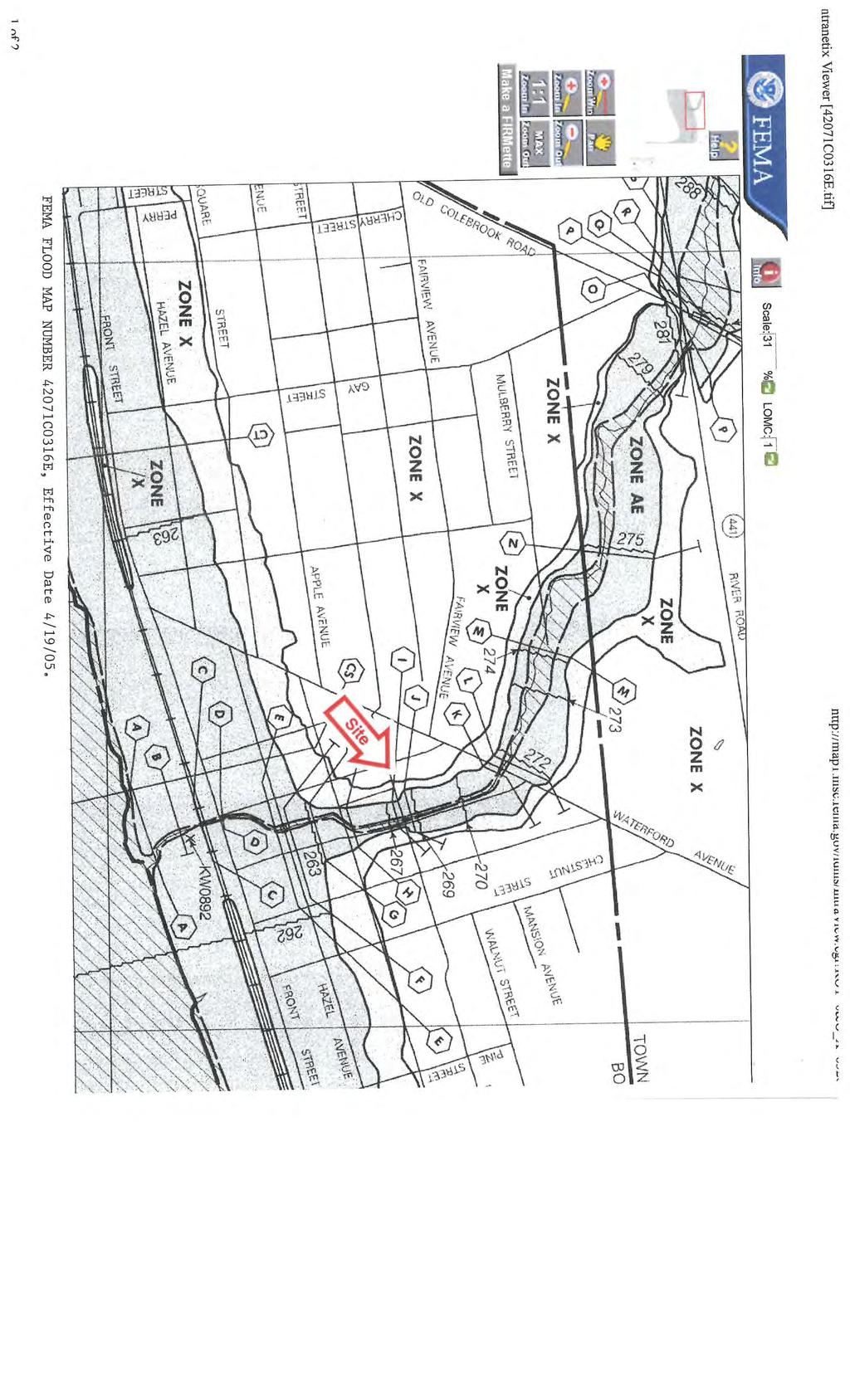
1 Environmental Review Part 55 Floodplain Management Subpart C 8-Step Decision Making Process Project: Acquisition and Demolition of a Blighted Structure - 1 North Strawberry Avenue, Marietta PA Description: The Marietta Restoration Associates is requesting the use of CDBG funding for the acquisition and demolition of a vacant, blighted structure on a 0.5-acre tract of land located partially in the 100-year floodplain. The future use of the land will include public parking and greenspace to support two nearby public facilities. There is a potential impact in the floodplain with the proposed construction of the parking lot. The proposed project is located 1 N. Strawberry Ave, Marietta, PA, Lancaster County. Document Table of Contents: Step 1. Portion of the property is located in the 100-year Floodplain. Step 2. - Attached FIRM Map - Attached FEMA ESRI Map Early Notice and Public Review of Activities in a 100-Year Floodplain was published on May 24 th, Comment period ended June 9 th, 2016 after a minimum 15-day comment period was conducted. Four (4) comments were received during this time. Step 3. - Early Notice and Public Review of Activities in a 100-Year Floodplain - Proof of Publication - Copy of Comments Received - Copy of Correspondence with Informal Meeting to address comments. - Documentation on the identification and evaluation of practical alternatives to locating the proposed action in a floodplain. Following Steps were conducted by a consultant, RGS Associates, with expertise in storm water management, land planning and design, and construction practices. Step 4. Step 5. Step 6. - Documentation on the identification of the potential direct and indirect impacts associated with the occupancy or modification of the floodplain - Documentation on design or modification on proposed action to minimize the potential adverse impacts within the floodplain and to restore and preserve its natural and beneficial values.
2 Step 7. - Documentation on the Reevaluation of the proposed action Final Notice and Public Explanation of Proposed Activities in a 100-year Floodplain was published on June 20 th, Comment period will end June 28 th, 2016 after a minimum 7-day comment period is conducted. - Documentation of Reevaluation that there is no practicable alternative to locating the proposal in the floodplain - Final Notice and Public Explanation of Proposed Activities in a 100-year Floodplain.
3
4
5
6
7
8
 if this map is down National Geospatial-Intelligence Agency (NGA); Delta State University; Esri scott.mcafee@fema.")
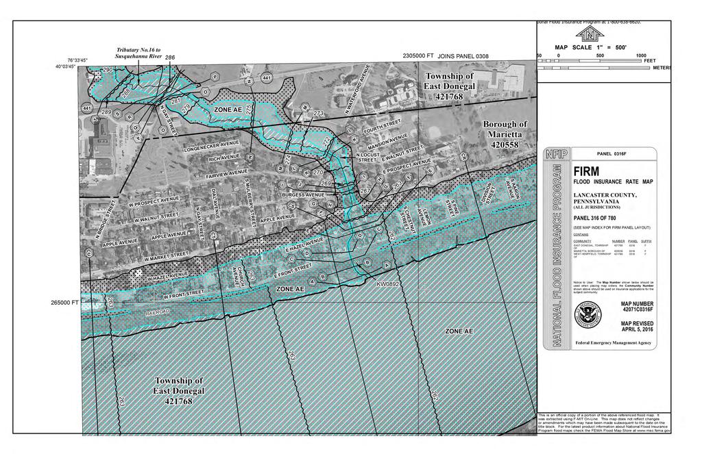
9 FEM A's N ational Flood Hazard Layer (Official) Data from Flood Insurance Rate Maps (FIRMs) where available digitally. Try (Unofficial) if this map is down National Geospatial-Intelligence Agency (NGA); Delta State University; Esri scott.mcafee@fema.dhs.gov
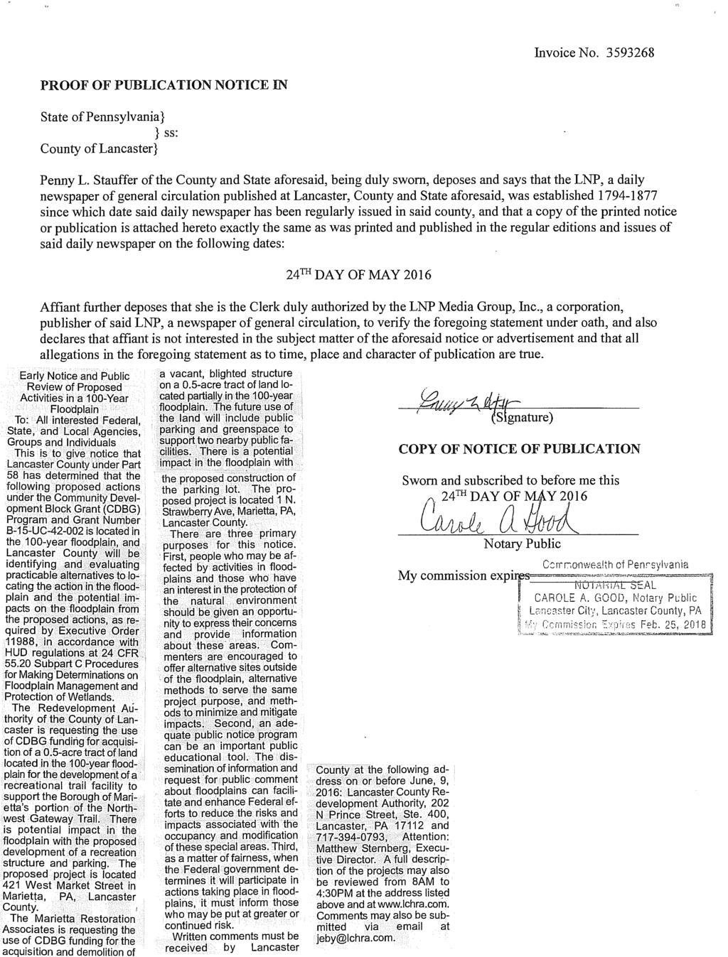
10 Early Notice and Public Review of Proposed Activities in a 100-Year Floodplain To: All interested Federal, State, and Local Agencies, Groups and Individuals This is to give notice that Lancaster County under Part 58 has determined that the following proposed actions under the Community Development Block Grant (CDBG) Program and Grant Number B-15-UC is located in the 100-year floodplain, and Lancaster County will be identifying and evaluating practicable alternatives to locating the action in the floodplain and the potential impacts on the floodplain from the proposed actions, as required by Executive Order 11988, in accordance with HUD regulations at 24 CFR Subpart C Procedures for Making Determinations on Floodplain Management and Protection of Wetlands. The Redevelopment Authority of the County of Lancaster is requesting the use of CDBG funding for acquisition of a 0.5-acre tract of land located in the 100-year floodplain for the development of a recreational trail facility to support the Borough of Marietta s portion of the Northwest Gateway Trail. There is potential impact in the floodplain with the proposed development of a recreation structure and parking. The proposed project is located 421 West Market Street in Marietta, PA, Lancaster County. The Marietta Restoration Associates is requesting the use of CDBG funding for the acquisition and demolition of a vacant, blighted structure on a 0.5-acre tract of land located partially in the 100-year floodplain. The future use of the land will include public parking and greenspace to support two nearby public facilities. There is a potential impact in the floodplain with the proposed construction of the parking lot. The proposed project is located 1 N. Strawberry Ave, Marietta, PA, Lancaster County. There are three primary purposes for this notice. First, people who may be affected by activities in floodplains and those who have an interest in the protection of the natural environment should be given an opportunity to express their concerns and provide information about these areas. Commenters are encouraged to offer alternative sites outside of the floodplain, alternative methods to serve the same project purpose, and methods to minimize and mitigate impacts. Second, an adequate public notice program can be an important public educational tool. The dissemination of information and request for public comment about floodplains can facilitate and enhance Federal efforts to reduce the risks and impacts associated with the occupancy and modification of these special areas. Third, as a matter of fairness, when the Federal government determines it will participate in actions taking place in floodplains, it must inform those who may be put at greater or continued risk. Written comments must be received by Lancaster County at the following address on or before June, 9, 2016: Lancaster County Redevelopment Authority, 202 N Prince Street, Ste. 400, Lancaster, PA and , Attention: Matthew Sternberg, Executive Director. A full description of the projects may also be reviewed from 8AM to 4:30PM at the address listed above and at Comments may also be submitted via at jeby@lchra.com. 5/23/2016
11
12
13
14
15
16
17
 that do not have adequate or dedicated parking.")
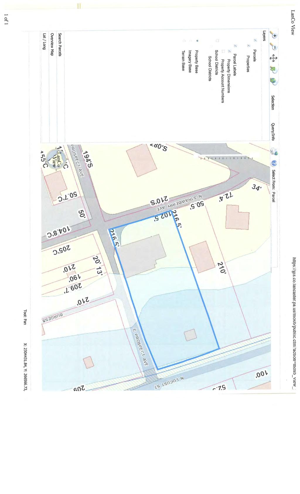
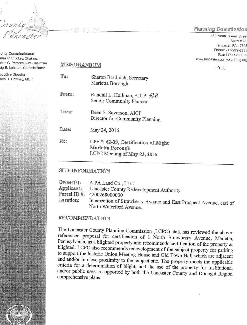
18 Step 3. Identify and evaluate practicable alternatives to locating the proposed action in a floodplain. CDBG funds are being requested for acquisition and demolition of a blighted property adjacent to two public facilities (shaded in black) that do not have adequate or dedicated parking. The building structure sits on the edge of the 500-year floodplain, but because the end use, as parking and greenspace, there exists a potential of impact on the 100-year floodplain, or lower portion of the property. Subject property (1 N Strawberry Ave) was identified for future parking and public space because of the condition of the property and structure. The property was certified blighted by the Vacant Property Reinvestment Board and Lancaster County Planning Commission. There were concerns with the integrity of the structure and all mechanical, electrical, and plumbing systems. No other locations, within proximity of the public facilities, existed with similar characteristics of that of a vacant/underutilized and unlivable property. Alternative parking locations were sought. Two locations were identified as potential temporary parking solutions; however, because of the density and residential make-up of the surrounding area, no other potential vacant or public land was identified for permanent parking for the two public facilities. Location A Susquehanna Waldorf, private school, with approximately 35 spaces available for parking and located adjacent to one of the public facilities, Old Town Hall. Because of evening and weekend events at the school, there may be conflicts for leased or mutually agreed upon use of the lot. Location B U.S. Postal Service, with approximately 20 spaces available for parking and located adjacent to one of the public facilities, Union Meeting House. Parking is not available during weekdays, evenings, or weekends because of use of the facility. Mail trucks are parked in the lot, residents and others park during the week while visiting the facility for USPS services and incoming/outgoing mail deliveries prohibit parking during the evenings and weekends.
19
20
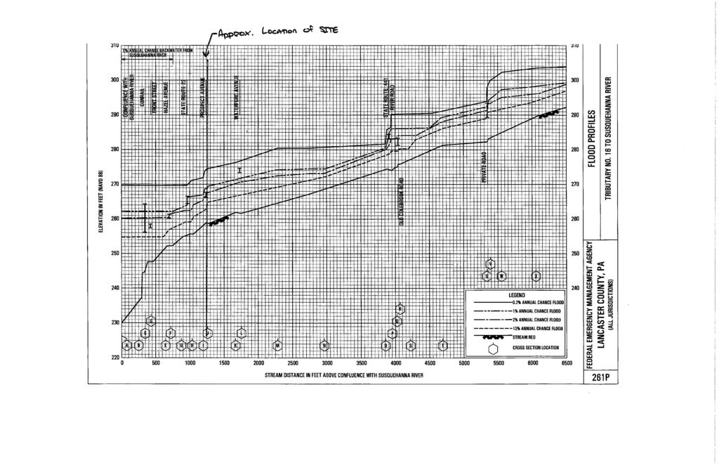
21 N. Strawberry Avenue Step 4: Identify Potential Direct and Indirect Impacts Associated with Floodplain Development Locating the project at N. Strawberry Avenue per the proposal will have minimal impacts to the floodplain. According to FEMA Flood Insurance Rate Map Number 42071C0316F, Panel 316, there are 500 and 100 year floodplains located at approximately and 269, respectively. The proposed site of a lower parking area is at an average elevation of approximately 266. The highest priority of this review is to prevent the loss of life. Because the proposed design does not include any habitable structures, evacuation of residents from the area during a flooding emergency will not be applicable. In addition, the design will not inhibit the evacuation of inhabitants from adjacent properties during warning periods prior to flooding. The proposed site development will not affect wetlands nor damage water, biological, and societal resources. The site has been previously developed, and the design of the future parking area will include appropriate Stormwater Best Management Practices to prevent any quantifiable impact on plant and animal life. The proposed development of this parking area will serve two existing historic structures which presently lack parking amenities. Future flooding will minimally affect the design or structural stability of the proposed parking areas. P:\2016\2016C20-003\Flood\N. Strawberry Avenue/Step 4.docx
22 N. Strawberry Avenue Step 5: Where practicable, design or modify the proposed action to minimize the potential adverse impacts to lives, property, and natural values within the floodplain and to restore, and preserve the values of the floodplain. (a) Preserving Lives: In order to preserve lives, the National Weather Service and the emergency broadcast system will implement an early warning announcement, should flooding conditions occur. The proposed parking areas will be constructed in order to allow efficient evacuation from the area. There will not be any structures proposed on the site to require specific evacuation protocol. (b) Preserving Property: In order to preserve property, flood insurance will also be acquired and maintained in order to mitigate possible flood damage. All proposed features will be designed in a manner to prevent debris from damaging adjacent properties. (c) Preserving Natural Values and Minimizing Impacts: The site will utilize a combination of traditional and pervious surfaces across the site. Additionally, stormwater Best Management Practices will be implemented to ensure water quality and to mitigate drainage impacts. P:\2016\2016C20-003\Flood\N. Strawberry Avenue\Step 5.docx
23 N. Strawberry Avenue Step 6: Reevaluate the Alternatives Although the Strawberry Avenue Site is within a FEMA designated floodplain, the project has been adapted in order to minimize effects on floodplain values. Additionally, steps were taken in order to minimize risks to human life and property as described in prior Steps 4 and 5. Alternative locations for the parking do not exist, given the density of surrounding proposed desirable Borough development and distances between historic venues and parking amenities. The lots which contain the historic structures are further constrained and unable to accommodate parking due to existing topography, limited site access, and an existing cemetery. Constructing the proposed improvements above the 100 year floodplain would require the placement of significant fill within the floodplain. This placement of fill would create a greater environmental impact, and would also make the proposed site redevelopment financially unviable. Due to the developed Borough context, this N. Strawberry Avenue site is the most ideal location to provide a low impact, safe solution to the need for additional parking facilities. P:\2016\2016C20-003\Flood\N. Strawberry Avenue\Step 6.docx
24 N. Strawberry Avenue Step 7: Determination of No Practicable Alternative It is RGS Associates determination that there is no practicable alternative to partially locating the proposed parking area within the flood zone. This is due to the desirable distance between parking and the historic venues, the cost of fully adapting the parking area to be out of the floodplain via imported fill materials, and the ability to minimize public risk and danger. Additionally, the design reduces potential damage to adjacent properties, and contamination of environmental habitats. P:\2016\2016C20-003\Flood\Step 4.docx
25
26
27 FILENAME: P:\2016\2016C20-003\CADD\Preliminary\Exhibits\ Strawberry Avenue.dwg PLOTTED: Friday, June 03, DATE: JUNE 3, 2016 PROJECT NO.: 2016C SCALE: 1" = 50' SHEET NO.: OF MARIETTA BOROUGH PROJECT TITLE N. STRAWBERRY AVENUE FLOODPLAIN DETERMINATION SHEET TITLE EXHIBIT A LANCASTER COUNTY, PA. CLIENT LCHRA 202 N. PRINCE ST. SUITE 400 LANCASTER, PA
28 Final Notice and Public Explanation of a Proposed Activities in a 100-Year Floodplain To: All interested Federal, State, and Local Agencies, Groups and Individuals This is to give notice that the County of Lancaster under Part 58 has conducted an evaluation as required by Executive Order 11988, in accordance with HUD regulations at 24 CFR Subpart C Procedures for Making Determinations on Floodplain Management and Wetlands Protection. The activity is funded under the Community Development Block Grant Program under Grant Number B-16-UC The Redevelopment Authority of the County of Lancaster is requesting the use of CDBG funding for acquisition of a 0.5-acre tract of land located in the 100-year floodplain for the development of a recreational trail facility to support the Borough of Marietta s portion of the Northwest Gateway Trail. There is potential impact in the floodplain with the proposed development of a recreation structure and parking. The proposed project is located 421 West Market Street in Marietta, PA, Lancaster County. The County of Lancaster has considered the following alternatives and mitigation measures to be taken to minimize adverse impacts and to restore and preserve natural and beneficial values: Alternative locations for the project site are restricted based on the location of the existing trail and the developed Borough context. Because the trail adjacent to the project site is entirely located within the floodplain, any feasible site to be analyzed for alternative construction to serve trail users would have similar design constraints. The new structure will include markings to identify past and estimated flooding elevations, the structure will be constructed of masonry block or comparable material to save on flood insurance cost and to enhance the structure s ability to withstand floods, will be placed at the maximum elevation practical within the design constraints of the site, and all construction will be elevated and consistent with FEMA s Lowest Floor Guide. All proposed development will be regulated at both a municipal level by Marietta s 2014 Stormwater Management Ordinance and at a County/Commonwealth/Federal level by the Chapter 102 regulations related to Post Construction Stormwater Management. The Marietta Restoration Associates is requesting the use of CDBG funding for the acquisition and demolition of a vacant, blighted structure on a 0.5-acre tract of land located partially in the 100-year floodplain. The future use of the land will include public parking and greenspace to support two nearby public facilities. There is a potential impact in the floodplain with the proposed construction of the parking lot. The proposed project is located 1 N. Strawberry Ave, Marietta, PA, Lancaster County. The County of Lancaster has considered the following alternatives and mitigation measures to be taken to minimize adverse impacts and to restore and preserve natural and beneficial values: Alternative locations for the parking do not exist, given the density of surrounding proposed desirable Borough development and distances between historic venues and parking amenities. The lots which contain the historic structures are further constrained and unable to accommodate parking due to existing topography, limited site access, and an existing cemetery. The site will utilize a combination of traditional and pervious surfaces across the site, stormwater Best Management Practices will be implemented to ensure water quality and to mitigate drainage impacts. All proposed development will be regulated at both a municipal level by Marietta s 2014 Stormwater Management Ordinance and at a County/Commonwealth/Federal level by the Chapter 102 regulations related to Post Construction Stormwater Management.
29 The County of Lancaster has reevaluated the alternatives to building in the floodplain for the above activities and has determined that it has no practicable alternative. Environmental files that document compliance with steps 3 through 6 of Executive Order 11988, are available for public inspection, review and copying upon request at the times and location delineated in the last paragraph of this notice for receipt of comments. There are three primary purposes for this notice. First, people who may be affected by activities in floodplains and those who have an interest in the protection of the natural environment should be given an opportunity to express their concerns and provide information about these areas. Second, an adequate public notice program can be an important public educational tool. The dissemination of information and request for public comment about floodplains can facilitate and enhance Federal efforts to reduce the risks and impacts associated with the occupancy and modification of these special areas. Third, as a matter of fairness, when the Federal government determines it will participate in actions taking place in floodplains, it must inform those who may be put at greater or continued risk. Written comments must be received by the County of Lancaster at the following address on or before June 28, 2016: Lancaster County Redevelopment Authority, 202 N Prince Street, Ste. 400, Lancaster, PA and , Attention: Matthew Sternberg, Executive Director. A full description of the project may also be reviewed from 8AM to 4:30PM at the address listed above and at Comments may also be submitted via at jeby@lchra.com. 06/20/2016
17.1 INTRODUCTION CONTEXT CONCLUSIONS
 CHAPTER 17. FLOODPLAIN 17.1 INTRODUCTION 17.1.1 CONTEXT A floodplain is part of an extensive drainage and filtration system and water cycle that serves to contain flood waters from storms. Floodplain areas
Northeast Ohio Regional Sewer District Stormwater Management Plan Review Policy
 Northeast Ohio Regional Sewer District Stormwater Management Plan Review Policy Introduction As a component of the Northeast Ohio Regional Sewer District s (District) Regional Stormwater Management Program,
Zoning Ordinance Article 3
 Article 3 Natural Resources Protection Section 301 Natural Resources Protection 301.1. Purpose - The following natural resources protection standards are established to protect the public health, safety
Camden SMART Initiative Stormwater Management and Resource Training
 Camden SMART Initiative Stormwater Management and Resource Training www.camdensmart.com Camden s Struggle with Stormwater 1 The City of Camden is served by a combined sewer system, which uses the same
Riparian Buffer on the Bushkill Creek. Policies
 Riparian Buffer on the Bushkill Creek Riparian buffers provide numerous benefits to landowners and the community by protecting groundwater recharge areas, providing flood control, providing stormwater
Neo-Traditional Overlay Application
 MAYOR AND CITY COUNCIL OF LAUREL DEPARTMENT OF ECONOMIC AND COMMUNITY DEVELOPMENT 8103 Sandy Spring Road Laurel, Maryland 20707 (301) 725-5300 Internet Address http://www.cityoflaurel.org E-mail: ecd@laurel.md.us
Chesapeake Bay Critical Area Conservation Plan
 The Maryland-National Capital Park and Planning Commission Prince George s County Planning Department Development Review Division 301-952-3530 Note: Staff reports can be accessed at www.mncppc.org/pgco/planning/plan.htm.
When planning stormwater management facilities, the following principles shall be applied where possible.
 2.0 Principles When planning stormwater management facilities, the following principles shall be applied where possible. 2.0.1 Drainage is a regional phenomenon that does not respect the boundaries between
COUNTY COUNCIL OF PRINCE GEORGE'S COUNTY, MARYLAND SITTING AS THE DISTRICT COUNCIL 2010 Legislative Session. Council Members Dernoga and Olson
 DR- COUNTY COUNCIL OF PRINCE GEORGE'S COUNTY, MARYLAND SITTING AS THE DISTRICT COUNCIL 00 Legislative Session Bill No. CB--00 Chapter No. Proposed and Presented by Introduced by Co-Sponsors The Chairman
City of Meriden Harbor Brook Flood Control Project Overview
 City of Meriden Harbor Brook Flood Control Project Overview Updated August 2013 OVERVIEW The center of Meriden, including the HUB site is the low point of the town which is ringed by basalt ridges. Running
GENERAL INFORMATIONaaaaaaaaaaaaaaaaaaaaaaaaaaaaaaaa
 To: Planning and Zoning Commission From: City Staff Date: November 15, 2016 Re: Case #16026 Raymore Activity Center Site Plan GENERAL INFORMATIONaaaaaaaaaaaaaaaaaaaaaaaaaaaaaaaa Applicant/ Property Owner:
DRAFT MAP AMENDMENT FLU 04-4
 DRAFT MAP AMENDMENT FLU 04-4 SW 24 TH AVENUE ROADWAY CORRIDOR The University of Florida participates with the Metropolitan Transportation Planning Organization (MTPO) in its responsibilities for the continuing,
Project phasing plan (if applicable) 12 copies of site plan
 12 copies of site plan") SITE PLAN REVIEW PERMIT APPLICATION City of Grand Haven, 11 N. Sixth Street, Grand Haven, MI 49417 Phone: (616) 847-3490 Fax: (616) 844-2051 Website: www.grandhaven.org 1. Project Information Address/location
SITE PLAN REVIEW PERMIT APPLICATION City of Grand Haven, 11 N. Sixth Street, Grand Haven, MI 49417 Phone: (616) 847-3490 Fax: (616) 844-2051 Website: www.grandhaven.org 1. Project Information Address/location
TOWNSHIP OF LOGAN SOIL & FILL IMPORTATION AND PLACEMENT APPLICATION SUBMITTAL CHECKLIST
 TOWNSHIP OF LOGAN SOIL & FILL IMPORTATION AND PLACEMENT APPLICATION SUBMITTAL CHECKLIST Applications: 5 copies of application - Applicant will reproduce the copies at his/her costs. The Township Clerk
PLANNING APPROVAL & PLANNED UNIT DEVELOPMENT Date: April 6, 2017
 PLANNING APPROVAL & PLANNED UNIT DEVELOPMENT Date: April 6, 2017 DEVELOPMENT NAME LOCATION Mobile Christian School 5900 Cottage Hill Road (North side of Cottage Hill Road, 230 ± West of Freemont Drive
Floodplain Management Plan 2016 Progress Report
 PREPARED FOR: Borough of Point Pleasant Beach 416 New Jersey Ave. Point Pleasant Beach, NJ 08742 (732) 892-1118 http://www.pointpleasantbeach.org/ PREPARED BY: T&M Associates 11 Tindall Road Middletown,
The Residences at Alewife Station
 The Residences at Alewife Station 195 & 211 Concord Turnpike Community Meeting Peabody School November 10, 2016 Site Context Special District 4 Special District 4 Restored Planned Development Special District
Winston-Salem State University Campus Master Plan 2016 Update
 Winston-Salem State University Campus Master Plan 2016 Update Request for Qualifications Page 1 of 6 Overview Winston-Salem State University (WSSU) is requesting qualifications from planning firms specializing
At Your Disposal CUP Amendment, Lot 20, Village Service Commercial, at 128 Bastille Dr. (PLN17-208)
") MEMORANDUM Archuleta County Development Services Planning Department 1122 HWY 84 P. O. Box 1507 Pagosa Springs, Colorado 81147 970-264-1390 Fax 970-264-3338 TO: Archuleta County Planning Commission FROM:
MEMORANDUM Archuleta County Development Services Planning Department 1122 HWY 84 P. O. Box 1507 Pagosa Springs, Colorado 81147 970-264-1390 Fax 970-264-3338 TO: Archuleta County Planning Commission FROM:
Appendix E Preliminary Location Hydraulic Study
 Appendix E Prepared for: State of Alaska Department of Transportation and Public Facilities Prepared by: HDR Alaska, Inc. 2525 C Street, Suite 305 Anchorage, Alaska 99503 February 2014 This page intentionally
SECTION 4(f) DE MINIMIS DOCUMENTATION
 DE MINIMIS DOCUMENTATION") SECTION 4(f) DE MINIMIS DOCUMENTATION Illinois Route 60/83 IL 176 to the intersection of IL 60 (Townline Road) Lake County P-91-084-07 Mundelein Park and Recreation District Project Limit SECTION 4(f)
SECTION 4(f) DE MINIMIS DOCUMENTATION Illinois Route 60/83 IL 176 to the intersection of IL 60 (Townline Road) Lake County P-91-084-07 Mundelein Park and Recreation District Project Limit SECTION 4(f)
SEMSWA s Role in the Land Development Process
 SEMSWA s Role in the Land Development Process One of SEMSWA s responsibilities is to ensure that any new development or redevelopment within its service area is designed and constructed in compliance with
TREASURE COAST REGIONAL PLANNING COUNCIL M E M O R A N D U M. February 19, 2010 Regional Planning Council Meeting
 TREASURE COAST REGIONAL PLANNING COUNCIL M E M O R A N D U M To: Council Members AGENDA ITEM 5H From: Date: Subject: Staff February 19, 2010 Regional Planning Council Meeting Local Government Comprehensive
Northern Branch Corridor DEIS December 2011
 16 Floodplains 161 Chapter Overview 1611 Introduction The flowing chapter identifies floodplains found within the Northern Branch Corridor in accordance with Executive Order 11988, Floodplain Management
Proposed Variation to the Midleton Town Development Plan 2013
 Volume 1 Proposed Variation to the Midleton Town Development Plan 2013 Vacant Site Levy-Residential and Regeneration Areas Inclusion of new text and objective in relation to the Vacant Site Levy and Regeneration
TOWN OF WHITBY REPORT RECOMMENDATION REPORT
 TOWN OF WHITBY REPORT RECOMMENDATION REPORT REPORT TO: Council REPORT NO: PL 95-09 DATE OF MEETING: October 13, 2009 PREPARED BY: Planning/Public Works Joint Report FILE NO(S): N/A LOCATION: N/A REPORT
HOUSING ELEMENT GOALS, OBJECTIVES, AND POLICIES
 HOUSING ELEMENT GOALS, OBJECTIVES, AND POLICIES Goal 6 Maintain and enhance the supply of decent, safe, energy efficient and affordable housing and maximize viable options and opportunities for present
ST. MARY S SOIL CONSERVATION DISTRICT (SMSCD) AND DPW&T CONCEPT EROSION AND SEDIMENT CONTROL AND STORMWATER MANAGEMENT GUIDELINES AND CHECKLIST
 AND DPW&T CONCEPT EROSION AND SEDIMENT CONTROL AND STORMWATER MANAGEMENT GUIDELINES AND CHECKLIST") St. Mary s Soil Conservation District 26737 Radio Station Way, Suite B Leonardtown, MD 20650 Phone: 301-475-8402 ext. 3 Fax: 301-475-8391 www.stmarysscd.com St. Mary s County Government Department of Public
St. Mary s Soil Conservation District 26737 Radio Station Way, Suite B Leonardtown, MD 20650 Phone: 301-475-8402 ext. 3 Fax: 301-475-8391 www.stmarysscd.com St. Mary s County Government Department of Public
Chapter 3 Site Planning and Low Impact Development
 CHAPTER 3 Site Planning and Low Impact Development Chapter 3 Site Planning and Low Impact Development 3.0 Introduction The City of Charleston requires that major residential, large commercial (>1 acre),
EXHIBIT A CITY OF FORT WALTON BEACH, FLORIDA COASTAL MANAGEMENT & CONSERVATION
 EXHIBIT A CITY OF FORT WALTON BEACH, FLORIDA INTRODUCTION The Coastal Management and the Conservation Elements required by Chapter 9J-5.012 and 5.013, F.A.C., respectively, have been combined into one
Public Hearing. Charlotte County-Punta Gorda MPO - Meeting Rooms A and B March 14, open house at 4 p.m., formal presentation at 5 p.m.
 Public Hearing Charlotte County-Punta Gorda MPO - Meeting Rooms A and B March 14, 2019 open house at 4 p.m., formal presentation at 5 p.m. Welcome to the Public Hearing for the Harborview Road (CR 776)
PLANNED UNIT DEVELOPMENT & PLANNING APPROVAL STAFF REPORT Date: April 4, 2013
 PLANNED UNIT DEVELOPMENT & PLANNING APPROVAL STAFF REPORT Date: April 4, 2013 NAME LOCATION The North American Islamic Trust, Inc. 63 East Drive (East side of East Drive, 400 South of Old Shell Road, and
Existing Conditions and Environmental Consequences Floodplains
 3.9 Environmental Consequences 3.8 3.8.1 WHAT ARE FLOODPLAINS? are low-lying areas adjacent to rivers, streams, and other waterbodies that are susceptible to inundation (flooding) during rain events. These
Chapter 5: Natural Resources and Environment
 NATURAL RESOURCES AND ENVIRONMENT 5-1 5 Chapter 5: Natural Resources and Environment BACKGROUND AND INTENT Urban expansion represents the greatest risk for the future degradation of existing natural areas,
7 May 9, 2012 Public Hearing APPLICANT AND PROPERTY OWNER: COASTAL ENTERPRISES, LLC
 7 May 9, 2012 Public Hearing APPLICANT AND PROPERTY OWNER: COASTAL ENTERPRISES, LLC REQUEST: Variance to Section 5B of the Site Plan Ordinance (Floodplain Regulations) ADDRESS / DESCRIPTION: 601 Sandbridge
VILLAGER SQUARE URBAN RENEWAL PLAN
 VILLAGER SQUARE URBAN RENEWAL PLAN City of Broomfield August 21, 1997 1 Table of Contents Villager Square Urban Renewal Project Urban Renewal Plan A. PREFACE 1 B, URBAN RENEWAL AREA BOUNDARIES 1 C. SUMMARY
Application for Certificate of Environmental Compatibility and Public Need
 Application for Certificate of Environmental Compatibility and Public Need Central Hudson Gas & Electric A and C Lines Towns of Pleasant Valley, LaGrange, Wappinger, and East Fishkill Dutchess County,
RECREATION AND OPEN SPACE ELEMENT GOALS, OBJECTIVES, AND POLICIES
 RECREATION AND OPEN SPACE ELEMENT GOALS, OBJECTIVES, AND POLICIES Goal 7 To provide park facilities, recreation programs, and open space resources that are safe, adequate, and accessible to all City residents,
Stormwater Regulations & Considerations Morse Study Area. Pam Fortun, P.E. CFM Senior Stormwater Treatment Engineer Engineering Services Division
 Stormwater Regulations & Considerations Morse Study Area Pam Fortun, P.E. CFM Senior Stormwater Treatment Engineer Engineering Services Division Stormwater Regulations Development Considerations Floodplain
SOUTH MAIN RIVER COMMUNITY REINVESTMENT PROJECT AREA PLAN DATED AUGUST 31, 2018
 SOUTH MAIN RIVER COMMUNITY REINVESTMENT PROJECT AREA PLAN DATED AUGUST 31, 2018 Redevelopment Agency of the City of Logan, Utah South Main River Community Reinvestment Project Area - 1 - INTRODUCTION 1.
PLANNING APPROVAL & PLANNED UNIT DEVELOPMENT Date: November 2, 2017
 PLANNING APPROVAL & PLANNED UNIT DEVELOPMENT Date: November 2, 2017 DEVELOPMENT NAME LOCATION Mobile Christian School 5900 Cottage Hill Road (North side of Cottage Hill Road, 230 ± West of Freemont Drive
LU Encourage schools, institutions, and other community facilities that serve rural residents to locate in neighboring cities and towns.
 Application No. 891627: Comprehensive Plan Text Amendment - Rural School Policies - Amend policies consistent with State Legislation allowing schools in the rural area and extension of sewer service to
STREAM BUFFERS
 88-415 STREAM BUFFERS 88-415-01 PURPOSE In the Kansas City region and throughout the nation, vegetated stream buffers have been clearly shown to protect stream stability and related infrastructure, improve
RECREATION, OPEN SPACE AND GREENWAYS ELEMENT GOALS, OBJECTIVES, AND POLICIES
 RECREATION, OPEN SPACE AND GREENWAYS ELEMENT GOALS, OBJECTIVES, AND POLICIES GOAL R-1: DEVELOP A RECREATION, OPEN SPACE AND GREENWAYS SYSTEM AS AN INTEGRAL COMPONENT OF AN OVERALL, COUNTY-WIDE ECONOMIC
Staff Report and Recommendation
 Community Planning and Development Planning Services 201 W. Colfax Ave., Dept. 205 Denver, CO 80202 p: 720.865.2915 f: 720.865.3052 www.denvergov.org/cpd TO: City Council Neighborhoods and Planning Committee
Roy L. Wickland 15 Belvedere Avenue - Belvedere, CA 94920
 Roy L. Wickland 15 Belvedere Avenue - Belvedere, CA 94920 June 19, Ms. Irene Borba Director of Planning and Building City of Belvedere ~1anning Department 450 San Rafael Avenue Belvedere, CA 94920 JUN.
SECTION 1 Introduction...1. SECTION 2 Regional Context Criteria for Planning Districts Description of Planning District...
 Table of Contents SECTION 1 Introduction...1 SECTION 2 Regional Context...2 2.1 - Criteria for Planning Districts...2 2.2 - Description of Planning District...2 SECTION 3 Goals & Objectives...5 SECTION
Services Department F May 28, 2007
 Report To: Development Services Committee Item: Date of Report: From: DS-07-144 May 23, 2007 Commissioner, Development File: Date of Meeting: Services Department F-7000-0013 May 28, 2007 Subject: Gibb
Green Gables. April 24, 2013
 Green Gables Preliminary and Final Plat April 24, 2013 Development Team Green Gables Development Corporation (Owner/Developer) DTJ Design (Planner/Landscape Architect) Enertia Consulting Group (Civil Engineer)
Using AutoCAD Civil 3D and ESRI ArcGIS to meet LEED-ND (Neighborhood Development) Requirements NDIA O Brien & Gere. All Rights Reserved.
 Requirements NDIA O Brien & Gere. All Rights Reserved.") Using AutoCAD Civil 3D and ESRI ArcGIS to meet LEED-ND (Neighborhood Development) Requirements NDIA 12457 1 Using AutoCAD Civil 3D and ESRI ArcGIS to meet LEED-ND (Neighborhood Development) Requirements
Using AutoCAD Civil 3D and ESRI ArcGIS to meet LEED-ND (Neighborhood Development) Requirements NDIA 12457 1 Using AutoCAD Civil 3D and ESRI ArcGIS to meet LEED-ND (Neighborhood Development) Requirements
EXECUTIVE SUMMARY DRAFT CHAPTER 1 INTRODUCTION EXECUTIVE SUMMARY
 CHAPTER 1 EXECUTIVE SUMMARY INTRODUCTION Through the joint efforts of the City of Tulsa planning staff and the Land Services division of Indian Nations Council of Governments (INCOG), the Berryhill Land
OFFICIAL CONTROLS IMPLEMENTATION LEGAL REQUIREMENTS
 IMPLEMENTATION The objective of the Implementation component of the Comprehensive Plan is to identify the changes that need to be made to the official controls in order to be consistent with the Comprehensive
INTRODUCTION. b. The extent to which such problems and objectives have been reduced or have increased subsequent to such date.
 INTRODUCTION INTRODUCTION The Municipal Land Use Law directs a Planning Board to prepare a Periodic Reexamination Report every six years that identifies and describes the following: a. The major problems
Appendix I. Checklists
 Appendix I Checklists Town of Greenwich Drainage Manual Department of Public Works - Engineering Division Town Hall - 101 Field Point Road, Greenwich, CT 06836-2540 Phone 203-622-7767 - Fax 203-622-7747
East Panorama Ridge Concept Plan Amendment
 Page 1 of 7 L003 : East Panorama Ridge Concept Plan Amendment Corporate NO: L003 Report COUNCIL DATE: March 4, 2002 REGULAR COUNCIL LAND USE TO: Mayor & Council DATE: February 27, 2002 FROM: General Manager,
PLANNED UNIT DEVELOPMENT Date: April 5, 2018
 PLANNED UNIT DEVELOPMENT Date: April 5, 2018 DEVELOPMENT NAME SUBDIVISION NAME LOCATION Robert Myers Robert Myers 2955 and 2989 Dauphin Street (Southeast corner of Dauphin Street and Sage Avenue) CITY
Developer s Program. The Station at East 54
 Developer s Program The Station at East 54 Existing Conditions The Station at East 54 is proposed for a 1.12 acre site at the northeast corner of Hamilton Road and Prestwick Road, tucked between the East
Meeting Agenda. 1. Introductions (5 min)
") Meeting Agenda Monaca, PA Ohio River Brownfields Redevelopment Planning Federal/State/Regional Partners Meeting June 5, 2012; 3-4pm EDT Conference call-in #: 1-866-299-3188 Conference code: 202 566 0633#
Meeting Agenda Monaca, PA Ohio River Brownfields Redevelopment Planning Federal/State/Regional Partners Meeting June 5, 2012; 3-4pm EDT Conference call-in #: 1-866-299-3188 Conference code: 202 566 0633#
Approved: CITY OF ARDEN HILLS, MINNESOTA PLANNING COMMISSION WEDNESDAY, AUGUST 5, :30 P.M. - ARDEN HILLS CITY HALL
 Approved: CITY OF ARDEN HILLS, MINNESOTA PLANNING COMMISSION WEDNESDAY, AUGUST 5, 2015 6:30 P.M. - ARDEN HILLS CITY HALL PLANNING CASES A. Planning Case 15-016; Final Planned Unit Development Arden Plaza;
EPOD Environmental Protection Overlay Districts.
 Chapter Environmental Protection Overlay Districts 200-21.Chapter 201 EPOD Environmental Protection Overlay Districts. A. Purpose and intent. The purpose of the EPOD established in this article is to provide
Re: Application Type: Proposed Highlands Redevelopment Area Designation
 CHRIS CHRISTIE Governor KIM GUADAGNO Lt. Governor State of New Jersey Highlands Water Protection and Planning Council 100 North Road (Route 513) Chester, New Jersey 07930-2322 (908) 879-6737 (908) 879-4205
Draft Environmental Assessment
 Draft Environmental Assessment CASCADE PARK Orem City, Utah A conversion of land protected under Section 6(f)(3) of the Land and Water Conservation Fund Act, Public Law 108-98 September 2017 For information,
EXHIBIT A. Tax Increment Reinvestment Zone No. 1 (Town Center) First Amended Project Plan 1
 First Amended Project Plan 1") EXHIBIT A Tax Increment Reinvestment Zone No. 1 (Town Center) First Amended Project Plan 1 1 As amended by Resolution No. 2008-02-001(TR1R) of the Tax Increment Reinvestment Zone No.1, and approved to
EXHIBIT A Tax Increment Reinvestment Zone No. 1 (Town Center) First Amended Project Plan 1 1 As amended by Resolution No. 2008-02-001(TR1R) of the Tax Increment Reinvestment Zone No.1, and approved to
Erosion & Sediment Control Plan Application Form & Checklist
 Erosion & Sediment Control Plan Application Form & Checklist GENERAL INFORMATION Application Date: Project Address: Tax Map / Parcel Number(s): PROPERTY OWNER / DEVELOPER Firm Name: Contact Person: Title:
Planning for and Managing Open Space and Natural Areas
 Planning for and Managing Open Space and Natural Areas Increasingly, development proposals in Delaware include large amounts of open space and natural areas. While open space is important as a community
Checklists. Project Name: Location: File Number: Date of Submittal: Reviewer: Date: Applicant: Contact Name: Phone Number:
 Applicant: Contact Name: Phone Number: Email: Project Name: Location: File Number: Date of Submittal: Reviewer: Date: Concept Plan Requirements: I. General Project Information 1. Address or parcel number
Appendix E Section 4(f) Evaluation
 Evaluation") Appendix E Section 4(f) Evaluation Appendix E Draft Section 4(f) Evaluation E.1 Introduction This appendix addresses a federal regulation known as Section 4(f), which protects parks, recreation areas,
Appendix E Section 4(f) Evaluation Appendix E Draft Section 4(f) Evaluation E.1 Introduction This appendix addresses a federal regulation known as Section 4(f), which protects parks, recreation areas,
ITS Concept Development Activity Descriptions
 ITS Concept Development Activity Descriptions October 2015 Procedures are subject to change without notice. Check the NJDOT website to ensure this is the current version. Table of Contents Concept Development
QUEEN-RIVER SECONDARY PLAN
 34 QUEEN-RIVER SECONDARY PLAN 34. QUEEN RIVER SECONDARY PLAN 1. INTRODUCTION The Queen-River area is approximately 6.4 hectares and is located at the eastern edge of the Downtown as shown on Map 34-1.
4. UTILITIES ELEMENT.
 4. UTILITIES ELEMENT. The purpose of this element is to provide for necessary public facilities and services correlated to future land use projections and population demand. Utilities Sub-Elements (A)
Shoreline Master Program Town of La Conner, Washington
 Shoreline Master Program Town of La Conner, Washington Department of Ecology approval effective Adopted September 24, 2013 by Town of La Conner Ordinance No.1106 Amended May 13, 2014 by Town of La Conner
Snohomish County Planning and Development Services
 Snohomish County Planning and Development Services John Lovick County Executive Clay White, Director 3000 Rockefeller Avenue M/S #604 Everett, WA 98201-4046 unchomish COUNT (425).Jgtg. Ax (425) 3 ^v32
Working Group Meeting
 April 4,, 2017 Parks Operations Bldg Working Group Meeting Arts Districts Overview Stormwater/RPA/Stream Considerations First Principles Agenda 7:00pm 7:05pm 7:10pm 7:40pm 8:30pm 9:40pm 9:45pm Welcome
G. RECREATION AND OPEN SPACE ELEMENT. The following summarizes the Recreation and Open Space Element:
 G. RECREATION AND OPEN SPACE ELEMENT The purpose of the Element is to provide the framework and direction for a comprehensive system of public and private sites for recreation, including, but not limited
Form to Submit Land for Residential Evidence Gathering Shepway Strategic Housing Land Availability Assessment (SHLAA) Partial Review
 Partial Review") Form to Submit Land for Residential Evidence Gathering Shepway Strategic Housing Land Availability Assessment (SHLAA) Partial Review All organisations and individuals who wish to put forward land for consideration
Form to Submit Land for Residential Evidence Gathering Shepway Strategic Housing Land Availability Assessment (SHLAA) Partial Review All organisations and individuals who wish to put forward land for consideration
EXISTING PLANS Harriet Festing Center for Neighborhood Technology Midlothian Community Meeting March 12, 2015
 EXISTING PLANS Harriet Festing Center for Neighborhood Technology Midlothian Community Meeting March 12, 2015 BENEFITS Bring economic, community + environmental benefits Enhance property values Use
TO: Port of Orcas FROM: Tina Whitman, Science Director SUBJECT: Master Plan Update DATE: September 7, 2018
 TO: Port of Orcas FROM: Tina Whitman, Science Director SUBJECT: Master Plan Update DATE: September 7, 2018 Friends of the San Juans appreciates the opportunity to provide input to the Port of Orcas Master
SDOT DPD. SDOT Director s Rule DPD Director s Rule DCLU DR SED DR of 7 CITY OF SEATTLE
 SDOT SDOT Director s Rule 2-07 DPD Applicant: CITY OF SEATTLE Page 1 of 7 Supersedes: DCLU DR 11-93 SED DR 93-4 Seattle Department of Transportation (SDOT) Department of Planning and Development (DPD)
Yadkin River Greenway Feasibility Study Fact Sheet Village of Clemmons, Town of Lewisville, Town of Bermuda Run
 Fact Sheet Village of Clemmons, Town of Lewisville, Town of Bermuda Run Project Background The Yadkin River Greenway Feasibility Study is a joint project with the Village of Clemmons, the Town of Bermuda
Improving an Urban Watershed The Past, Present and Future of Addison Creek
 Improving an Urban Watershed The Past, Present and Future of Addison Creek IAFSM Conference March 14, 2018 Stormwater Management 1 Stormwater Management 2 PAST Reservoirs and Channel Improvements Stormwater
Town of West Point Plan of Development
 Town of West Point Plan of Development Plan Submission In accordance with Section 70-51(b) of the Town Code, the Zoning Administrator shall establish a written policy for the form, format, content and
A G E N D A Council Update Training Room September 26, :45 p.m.
 CITY OF THORNTON CITY MANAGER S OFFICE A G E N D A Council Update Training Room September 26, 2017 5:45 p.m. A. Boards and Committees Reports (Estimated 20 Minutes) 1. Rangeview Library District Meeting
GENERAL PLAN UPDATE ISSUES MEETING. January 21, 2010 City Hall Mitchell Room 6:00 pm 9:00 pm
 GENERAL PLAN UPDATE ISSUES MEETING January 21, 2010 City Hall Mitchell Room 6:00 pm 9:00 pm WELCOME! Introductory Comments Continued Review of Quality of Life Standards, Growth Management, Proposition
PLANNED UNIT DEVELOPMENT & SUBDIVISION STAFF REPORT Date: May 18, 2017
 & PUD-0000102-2017 PLANNED UNIT DEVELOPMENT & SUBDIVISION STAFF REPORT Date: May 18, 2017 NAME SUBDIVISION NAME Dauphin Creek Estates Subdivision Dauphin Creek Estates Subdivision LOCATION CITY COUNCIL
City of Waco Stormwater Management Regulations
 1.0 Applicability: City of Waco Stormwater Management Regulations These regulations apply to all development within the limits of the City of Waco as well as to any subdivisions within the extra territorial
26/Old Dominion Task Force
 26/Old Dominion Task Force Meeting #9: March 21, 2019 Study Area Overview Staff Name, Department (DEPT ACRONYM) Preferred Scenarios Outline 1. Task Force Feedback from 3/7 2. Refined Concepts 3. Implementation
NEIGHBORHOOD DESIGN ELEMENT
 NEIGHBORHOOD DESIGN ELEMENT INTRODUCTION The following recommendations constitute an urban design oriented "neighborhood analysis" of Plantation. It is an optional Comprehensive Plan Element. The five
I. STAFF POLICY RECOMMENDATIONS. The following RMP policy strategies are proposed by staff in support of a Scenic Resource Protection Program:
 Policy Consideration: Scenic Resource Protection Program Status: For Consideration by the Highlands Council at September 14, 2006 Work session Date: September 12, 2006 I. STAFF POLICY RECOMMENDATIONS The
SITE PLAN REVIEW ITEMS - REFERENCE CHECKLIST
 City of Seminole 9199 113 th Street N. Seminole, FL 33772 Ph: (727) 392-1966 Fx: (727) 319-6583 SITE PLAN REVIEW ITEMS - REFERENCE CHECKLIST Note: This checklist is designed to aid designers in the review
A Sustainable SmartCode for Communities Impacted by Natural and Man-Made Disasters
 A Sustainable SmartCode for Communities Impacted by Natural and Man-Made Disasters Smart Growth & Sustainability University of Denver, Sturm College of Law Dave DeNovellis, Kimberly Jackson, Ian Rainey
DRAFT FOR COMMENT: EASTLAKE AVENUE PEDESTRIAN DISTRICT OVERLAY ORDINANCE
 DRAFT FOR COMMENT: EASTLAKE AVENUE PEDESTRIAN DISTRICT OVERLAY ORDINANCE Background: One of many actions in the 1998 Eastlake Neighborhood Plan was a proposal for an Eastlake Avenue Pedestrian District
Notice of Preparation and Notice of Public Scoping Meeting. At Dublin Project
 Notice of Preparation and Notice of Public Scoping Meeting Date January 17, 2018 To Project Title Project Application Number Project Location Project Applicant Contact For questions or submitting comments.
THE CITY OF MOBILE, ALABAMA
 THE CITY OF MOBILE, ALABAMA LETTER OF DECISION Ark of Safety, Inc. Mobile, AL 36617 Re: (Northwest corner of Main Street and First Avenue, extending to the Southwest corner of Esau Avenue and Main Street.)
OVERMOUNTAIN VICTORY TRAIL BURKE CALDELL CORRIDOR FEASIBLITY STUDY REQUEST FOR QUALIFICATIONS CALDWELL COUNTY PATHWAYS
 OVERMOUNTAIN VICTORY TRAIL BURKE CALDELL CORRIDOR FEASIBLITY STUDY REQUEST FOR QUALIFICATIONS CALDWELL COUNTY PATHWAYS Caldwell County Pathways along with our co-partners City of Lenoir, Town of Gamewell,
Draft Rhode Island Stormwater Design and Installation Standards Manual
 Draft Rhode Island Stormwater Design and Installation Standards Manual Summary The May 2009 Public Review Draft version of the RI Stormwater Design and Installation Standards Manual consists of approximately
ARTICLE VI: SITE PLAN REVIEW
 Section 6.01 - Site Plan Review (All Districts) ARTICLE VI: SITE PLAN REVIEW Site plans give the Planning commission an opportunity to review development proposals in a concise and consistent manner. The
SECTION II SECTION II STATEMENT OF GOALS, OBJECTIVES, PRINCIPLES, ASSUMPTIONS, POLICIES AND STANDARDS
 STATEMENT OF GOALS, OBJECTIVES, PRINCIPLES, ASSUMPTIONS, POLICIES AND STANDARDS 1 2 STATEMENT OF GOALS, OBJECTIVES, PRINCIPLES, ASSUMPTIONS, POLICIES AND STANDARDS INTRODUCTION The New Jersey Municipal
ARTICLE V PLANNED UNIT DEVELOPMENT DISTRICT
 ARTICLE V PLANNED UNIT DEVELOPMENT DISTRICT A. Purpose and Objective The Planned Unit Development (PUD) procedure provides a flexible land use and design regulation through the use of performance criteria
City of Larkspur. Notice of Mitigated Negative Declaration for the 285
 Notice of Mitigated Negative Declaration for the 285 Magnolia Avenue Mixed-Use Project Date: December 2, 2013 Responsible Agency: Project Title: 285 Magnolia Avenue Mixed-Use Project Project Address: 285
Chapter 10 IMPLEMENTATION RECOMMENDATIONS
 Chapter 10 IMPLEMENTATION RECOMMENDATIONS The recommended land use plan presented in the previous chapter provides a design for the attainment of the urban and rural development and open space preservation