The Residences at Alewife Station
|
|
|
- Darren Arnold
- 5 years ago
- Views:
Transcription
1 The Residences at Alewife Station 195 & 211 Concord Turnpike Community Meeting Peabody School November 10, 2016

2 Site Context Special District 4


3 Special District 4 Restored Planned Development


4 Special District 4 Restored
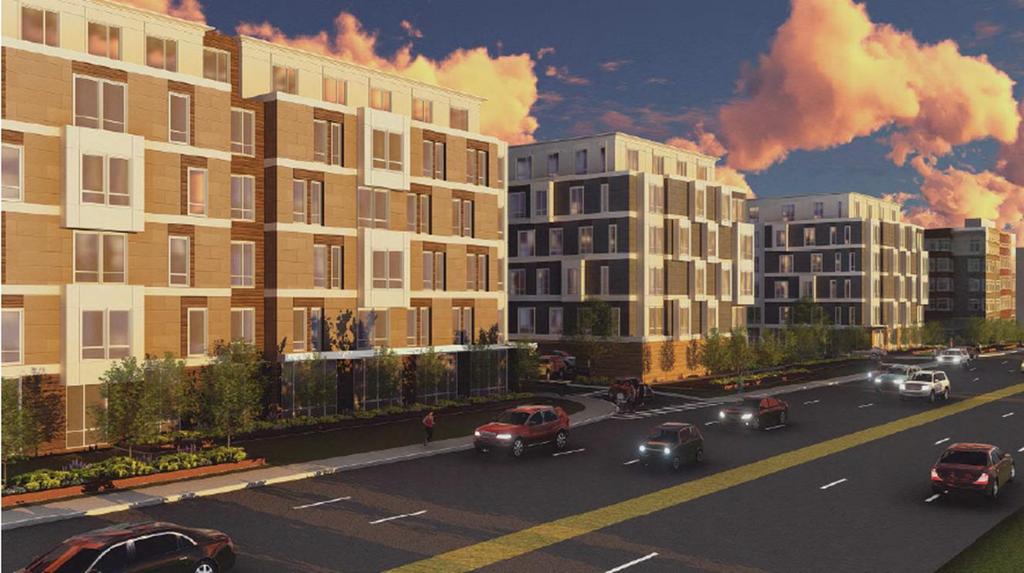
5 The Residences at Alewife Station Site Plan & Architecture

6 Site Context Plan

7 Site Context Plan Birdseye looking North Birdseye looking South

8 Existing Site Conditions
9 Site Constraints RT. 2 / Concord Turnpike VOX Garage Garage Existing Drive Pedestrian Access
10 Breaking Down the Street Wall
11 Breaking Down the Street Wall
12 Creating Open Space Raingarden Entry Court Drive Courtyard Courtyard Raingarden

13 Creating Open Space Raingarden Entry Court Drive Courtyard Courtyard Courtyard Courtyard Courtyard Raingarden
14 TWO WAY TWO WAY Site Access Plan ONE WAY ONE WAY TWO WAY TWO WAY SERVICE
15 Major Pedestrian Routes BIKE BIKE BIKE BIKE
16 Site Plan 320 rental units 200-space garage 42 surface parking spaces

17 Building 1 Looking East

18 Building 1Bridge & Site Access

19 Building 1Bridge & Site Access

20 Building 2 Looking East
21 View Looking West

22 Building 2 Entry & Site Egress

23 Access Drive Looking West

24 Access Drive Looking North to RT.2

25 Building 2 Courtyard

26 Access Drive Looking East
27 Project Summary 320 rental units (studio, 1, 2 & 3 bedroom) 242 parking spaces (200 in garage, 42 other) 5 stories over parking (68 feet) 324,612 GSF building 1.95 FAR
28 The Residences at Alewife Station Site Improvements
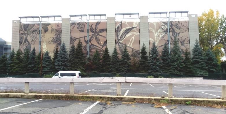
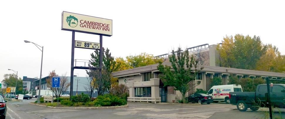
29 Site Improvements In accordance with the Massachusetts Wetlands Protection Act (WPA) 310 CMR and the Stormwater Management Handbook guidelines for Redevelopment Projects, the project analyzed the following existing and proposed conditions: Impervious & Pervious Groundcover Areas Stormwater Management & Water Quality Treatment 100 Buffer to Bordering Vegetated Wetlands Land Subject to Flooding (Resource Area)

30 Existing Site Conditions Lot Area = 3.8 acres Impervious Area = 92.9% Minimal Stormwater Treatment Small Portion of lot located within 100-foot wetland buffer Located within FEMA 100-year Floodplain

 Project adds nearly one (1) acre")
31 Impervious & Pervious Groundcover Areas Existing Site = 3.8 acres Impervious Area = 3.6 acres (93%) Proposed Impervious Area = 2.6 acres (70%) Project adds nearly one (1) acre of new pervious area
 Water Quality Treatment Units (i.e. Stormceptor or approved equal)")
32 Stormwater Management & Water Quality Treatment The project will employ natural & structural Best Management Practices (BMPs) to manage & treat stormwater runoff: Wet Pond Rain Garden Catch Basins (Deep Sump w/ Hoods) Water Quality Treatment Units (i.e. Stormceptor or approved equal)


33 Bordering Vegetated Wetlands on Adjacent Site
 M o t e l")

34 100 Buffer to Bordering Vegetated Wetlands Existing Total Buffer Area = 13,248 sf Impervious Area = 9,630 sf (73%) M o t e l Proposed Impervious Area = 4,900 sf (37%) Proposed Building Parking Lot Wet Pond Project significantly reduces impervious surface in buffer area
35 Land Subject to Flooding Design based upon current FEMA floodplain mapping for 100-Year Storm Event AND the City of Cambridge Climate Change Vulnerability Assessment (CCVA) Projections for 2030 & year storms Recommendation to design to 2030 projection and show ability to recover from 2070 projection
36 Existing Conditions Existing 100-Year FEMA Floodplain Cambridge Gateway Inn Lanes and Games FEMA 100-year Flood Elevation = 6.8 3,748 CY of Existing Flood Storage

37 Existing Conditions Projected Year Floodplain CCVA s Estimated year Flood Elevation = 7.5 6,276 CY of Existing Available Flood Storage

38 100-Year FEMA and 2030 Floodplain Mitigation
39 Proposed Conditions 100-Year FEMA Floodplain FEMA 100-year Flood Elevation = 6.8 Underside/Bottom of Garage Slabs located at elevation 7.5 4,172 CY of Available Flood Storage Created Project provides an additional 424 CY of Available Flood Storage

40 Proposed Conditions Proposed Year Floodplain Estimated 100- year Flood Elevation = 7.46 Parking garage slabs set at 7.5 ; building lobbies set at elevation 8.5 7,174 CY of Available Flood Storage Created Project provides an additional 898 CY of Available Flood Storage
41 Proposed Conditions Proposed Year Floodplain Estimated 100-year Flood Elevation (Based upon Estimated Sea Level Rise AND Storm Surge = NAVD Key Building Elevations: Underside/Bottom of Parking garage slabs - Elevation 7.5 NAVD Building lobbies & first floor amenity space - Elevation 8.5 NAVD Residential Units Approximate Elevation 21.0 NAVD Building Ground floor space (lobby & amenities area) and Parking Garage Entries will utilize flood gates at openings during forecasted 100- Year Storm Events and other major storm events.
42 Site Improvements Summary Impervious & Pervious Groundcover Areas Replaces almost an acre of impervious area with pervious area Stormwater Management & Water Quality Treatment - Significant improvements over existing conditions; including reduction in peak flows & water quality treatment 100 Buffer to Bordering Vegetated Wetlands Impervious area in the buffer zone will be reduced by almost 50% Stormwater runoff captured and treated prior to discharge to adjacent wetlands Land Subject to Flooding Increases onsite flood storage capacity Meets the recommendations of the City s Climate Change Vulnerability Assessment Accommodates the yr flood projection and able to recover from 2070 projection
43 The Residences at Alewife Station Traffic Assessment
44 Traffic Study Elements Study Area approved by Traffic Department Existing Conditions Vehicles Pedestrians Bicycles Vox on Two Background Traffic Growth Project Traffic Project Impacts Proposed Mitigation

45 Study Area
46 Existing Peak Hour Site Trip Generation Weekday Morning Entering Exiting Total Weekday Evening Entering Exiting Total
47 Vox on Two Monitoring Survey 222 of 227 units are leased The mode type of all weekly trips made by current tenants included: 35% single occupancy vehicle 4% rideshare 45% public & private transit 8% walk 4% bike 4% other (includes work from home) 44 to 62% fewer peak hour vehicle trips than originally estimated

48 Public Transit

49 Private Transit

50 Pedestrian & Bike Paths
51 Weekday Peak Hour Project Trip Generation Total SOV Rideshare Transit Pedestrian Bicycle Other Morning Evening
52 Net New Peak Hour Project Trips Weekday Morning Entering Exiting Total Proposed Existing Net New Trips (10) Weekday Evening Entering Exiting Total (1) 5 4
53 Project Mitigation Focus is to reduce single occupancy vehicle use: Provide ample bicycle storage & maintenance areas Provide 20 bicycles for tenant s use at no charge Provide each tenant with a complimentary Charlie Card for one month upon leasing Appoint a Transportation Demand Manager Submit annual monitoring reports
54 The Residences at Alewife Station Community Engagement

55 courbanize Visit the project page using the web address courb.co/ras Learn about new project information, see the timeline and stay in the loop We ll post information about meetings and milestone events


56 courbanize Two ways to participate: add comments or questions - all comments go right to the project development team and we ll respond directly Follow to subscribe & get project updates from the development team by Comment Follow
57 Discussion
Innovation. Collaboration. Inspiration.
 Innovation. Collaboration. Inspiration. WHERE IDEAS AND COMPANIES GROW An urban oasis in a world-class city. Cambridge Discovery Park is a 27-acre first-class office and research campus on Route 2 in Cambridge,
The subject site plan amendment proposes the following revisions to the approved site plan:
 PROPOSED AMENDMENT The subject site plan amendment proposes the following revisions to the approved site plan: 1. The building footprint was modified to accommodate the revised architectural design. 2.
Chapter 3 Site Planning and Low Impact Development
 CHAPTER 3 Site Planning and Low Impact Development Chapter 3 Site Planning and Low Impact Development 3.0 Introduction The City of Charleston requires that major residential, large commercial (>1 acre),
GRACE CHURCH EXPANSION
 GRACE CHURCH EXPANSION REVIEW: NOVEMBER 24, 2014 200 SAGE ROAD, CHAPEL HILL NORTH CAROLINA PROJECT DATA OVERALL SITE MAP SITE INFORMATION OWNER PIN ACREAGE VICINITY MAP GRACE CHURCH 9890503171 271,600
Appendix E: Illustrative Green Infrastructure Examples
 Appendix E: Illustrative Green Infrastructure Examples Integrating LID into San Francisco s Urban Landscape Figure E. High-density Residential Figure E. Low-density Residential Figure E. Mixed Use 7 Figure
The Benefits and Challenges Associated with Green Infrastructure Practices
 The Benefits and Challenges Associated with Green Infrastructure Practices Thomas M. Evans ASLA, LEED AP Regional Green Infrastructure Design Services Director OWEA Technical Conference, June 20, 2013
LID Permit Requirements. Lisa Austin. Geosyntec Consultants
 LID Permit Requirements Lisa Austin Geosyntec Consultants Presentation Outline Types of LID Permit Requirements Specified site design Specified LID BMPs LID performance metrics Specified Site Design (San
Draft Rhode Island Stormwater Design and Installation Standards Manual
 Draft Rhode Island Stormwater Design and Installation Standards Manual Summary The May 2009 Public Review Draft version of the RI Stormwater Design and Installation Standards Manual consists of approximately
RIVERSIDE, Newton MA June 9, 2011
 June 9, 2011 TONIGHT S AGENDA: 1.Project Update (5 min.) 2.Master Plan Update (10 min.) 3.Environmental Update (5 min.) 4.Traffic Plan Update (25 min.) Questions PROJECT STATUS UPDATE Responding / Clarifying
Innovation. Collaboration. Inspiration.
 Innovation. Collaboration. Inspiration. WHERE IDEAS AND COMPANIES GROW An urban oasis in a world-class city. Cambridge Discovery Park is a 7-acre first-class office and research campus on Route in Cambridge,
What is stormwater runoff? Why is it a problem? Available Financial Incentives for Stormwater BMP s Downspout Disconnection - up to $20
 What is stormwater runoff? Stormwater is any form of natural precipitation (including ice and snow melt) that flows across undeveloped or developed land. In a natural setting, a majority of the water seeps
STORMWATER REPORT FOR WALMART SUPERCENTER STORE # SIOUX FALLS, LINCOLN COUNTY, SOUTH DAKOTA BFA PROJECT NO
 STORMWATER REPORT FOR WALMART SUPERCENTER STORE # 2443-00 SIOUX FALLS, LINCOLN COUNTY, SOUTH DAKOTA BFA PROJECT NO. 3286 March 1, 2012 I hereby certify that this engineering document was prepared by me
Environmental Review Part 55 Floodplain Management Subpart C. 8-Step Decision Making Process
 Environmental Review Part 55 Floodplain Management Subpart C 8-Step Decision Making Process - 55.20 Project: Acquisition and Demolition of a Blighted Structure - 1 North Strawberry Avenue, Marietta PA
Reconnecting New Haven: Downtown Crossing
 Reconnecting New Haven: Downtown Crossing Phase 2 Update Introduction to Phase 3 November 16, 2017 City of New Haven, Connecticut Toni N. Harp, Mayor Reconnecting New Haven Introduction Project Overview
Introduction Post-Construction Stormwater Management Performance Requirements
 EZ MANUAL Introduction Post-Construction Stormwater Management Performance Requirements The primary objective of these Post-Construction Stormwater Management Performance Requirements is to minimize the
2015 Campus Master Plan Update
 September 15, 2015 2015 Campus Master Plan Update Campus and Community Analysis Summary Presentation A G E N D A 1. Scope & Schedule of the Master Plan 2. Planning Principles & Draft Goals 3. Background
Pennsylvania Stormwater Best Management Practices Manual. Chapter 4. Integrating Site Design and Stormwater Management
 Pennsylvania Stormwater Best Management Practices Manual Chapter 4 Integrating Site Design and Stormwater Management 363-0300-002 / December 30, 2006 Chapter 4 Integrating Site Design and Stormwater Management
MALLETTS BAY INITIATIVE
 MALLETTS BAY INITIATIVE Stormwater Management & Transportation Scoping Study January 19, 2017 Project Team Bryan Osborne Director of Public Works Sarah Hadd Director of Planning & Zoning Marshall Distel
Springhill Suites by Marriot TR Limited DRI Hearing Hermann Foundation Room Falmouth Public Library
 TR14017 Limited DRI Hearing Hermann Foundation Room Falmouth Public Library Limited DRI Review Mandatory DRI: Sections 3(e) and 3(f) of the Enabling Regulations increase Gross Floor Area on-site by greater
SHEFFIELD PARK Paulding County, GA DRI #588
 SHEFFIELD PARK Paulding County, GA DRI #588 Supplemental Information for RDC s DRI (Form 2) Review August 16, 2004 Prepared for: Mr. David Howerin Coosa Valley RDC 1 Jackson Hill Drive Rome, GA 30161 P.O.
Appendix I. Checklists
 Appendix I Checklists Town of Greenwich Drainage Manual Department of Public Works - Engineering Division Town Hall - 101 Field Point Road, Greenwich, CT 06836-2540 Phone 203-622-7767 - Fax 203-622-7747
MDOT Stormwater BMPs: The Challenge of Design. Janeen McDermott, PE Dan DeVaun, PE
 MDOT Stormwater BMPs: The Challenge of Design Janeen McDermott, PE Dan DeVaun, PE June 25, 2018 Outline Water Quality Treatment Water Quality Treatment Volume Guidelines Example Project BMP Design Challenges
LID CASE STUDY DESIGN WORKSHOP HSG B/D SOIL EXAMPLE SINGLE FAMILY SUBDIVISION WITH OUTPARCEL
 LID CASE STUDY DESIGN WORKSHOP HSG B/D SOIL EXAMPLE SINGLE FAMILY SUBDIVISION WITH OUTPARCEL B Y : M A R T Y W A N I E L I S T A A N D E R I C L I V I N G S T O N August, 2016 ACKNOWLEDGEMENTS The Low
Part 4: CRS Stormwater Management Activity (450) and Urban Flooding Best Practices
 and Urban Flooding Best Practices") Coastal Resilience through Community Engagement Webinar Series Part 4: CRS Stormwater Management Activity (450) and Urban Flooding Best Practices 1:00 2:30pm CT 8 Today s Moderator Chad Berginnis, CFM
Coastal Resilience through Community Engagement Webinar Series Part 4: CRS Stormwater Management Activity (450) and Urban Flooding Best Practices 1:00 2:30pm CT 8 Today s Moderator Chad Berginnis, CFM
Introduction Post Construction Stormwater Management Performance Requirements
 Introduction Post Construction Stormwater Management Performance Requirements The primary objective of these Post Construction Stormwater Management Performance Requirements is to minimize the downstream
HEALTH SCIENCES BUILDING REDEVELOPMENT PROJECT
 INTRODUCTION In recent years, the University of Cincinnati (University) has demonstrated a commitment to identifying and implementing sustainable goals and objectives throughout University s Uptown Campuses.
Existing Conditions. Planning and Design Principles
 penn s south bank enn s South Bank is located south of the Schuylkill River at the intersection of 4th Street and. This acre former heavy industrial site offers the opportunity to accommodate a variety
Development of land adjacent to Braggs Farm Lane and Rumbush Lane, Dickens Heath. Welcome. Today s exhibition. The proposal site
 Welcome Welcome to this event to discuss the development of land adjacent to Braggs Farm Lane. is currently in the preliminary stages of designing proposals to sensitively develop this site with high-quality
Chesapeake Bay Critical Area Conservation Plan
 The Maryland-National Capital Park and Planning Commission Prince George s County Planning Department Development Review Division 301-952-3530 Note: Staff reports can be accessed at www.mncppc.org/pgco/planning/plan.htm.
PART 1: PROJECT SUMMARY. The application is Attachment A. The site plan is Attachment B.
 Belleterre Subdivision Sketch Plan Town Board 8.7.17 Belleterre Subdivision Sketch Plan PART 1: PROJECT SUMMARY Applicant: Bowman Development Project Size: +/- 20.85 acres Parcel Number: 01115104 and 01115121
Gold Line Bus Rapid Transit Transit Oriented Development (BRTOD) Helmo Station Area Plan
 Helmo Station Area Plan") Appendix F Gold Line Bus Rapid Transit Transit Oriented Development (BRTOD) Helmo Station Area Plan Introduction and Purpose of the Plan The Gold Line Bus Rapid Transit facility is an eleven-mile dedicated
Appendix F Gold Line Bus Rapid Transit Transit Oriented Development (BRTOD) Helmo Station Area Plan Introduction and Purpose of the Plan The Gold Line Bus Rapid Transit facility is an eleven-mile dedicated
UNIVERSITY PRESBYTERIAN CHURCH - RENOVATION & ADDITION 209 EAST FRANKLIN ST., CHAPEL HILL, NC 27514
 UNIVERSITY PRESBYTERIAN CHURCH - RENOVATION & ADDITION 209 EAST FRANKLIN ST., CHAPEL HILL, NC 27514 PROJECT DATA OVERALL SITE MAP HDC CONCEPT PLAN SUBMITTAL: OCT. 8, 2012 SUP SUBMITTAL: MAY 28, 2013 SUP
MONTGOMERY COUNTY PLANNING DEPARTMENT
 MONTGOMERY COUNTY PLANNING DEPARTMENT THE MARYLAND-NATIONAL CAPITAL PARK AND PLANNING COMMISSION Ashburton Elementary School Addition, Mandatory Referral, MR2018009 MCPB Item No. Date: 02-15-18 Troy Leftwich,
Does Green Infrastructure Pay? WASHOE COUNTY COMMISSION CHAMBERS RENO, NEVADA
 Does Green Infrastructure Pay? WASHOE COUNTY COMMISSION CHAMBERS RENO, NEVADA JANE KULIK, ASLA WENK ASSOCIATES, INC MARCH 30, 2006 the dollars and sense of green infrastructure: examining costs and benefits
Structural Stormwater Best Management Practices
 Structural Stormwater Best Management Practices for Small Commercial and Residential Applications Timothy Bruno Watershed Manager PA Department of Environmental Protection What are STRUCTURAL BMPs? Physical
October 7, City of Thornton 9500 Civic Center Drive Thornton, CO (303) RE: Maverik Thornton, CO - Drainage Report
 RE: Maverik Thornton, CO - Drainage Report") October 7, 2016 City of Thornton 9500 Civic Center Drive Thornton, CO 80229 (303) 538-7295 RE: Maverik Thornton, CO - Drainage Report As per your request, we are submitting to you the drainage report and
October 7, 2016 City of Thornton 9500 Civic Center Drive Thornton, CO 80229 (303) 538-7295 RE: Maverik Thornton, CO - Drainage Report As per your request, we are submitting to you the drainage report and
Don Mills Crossing Study and Celestica Lands Development Application Community Meeting, Open House, and Breakout Discussions
 Consultation Summary Don Mills Crossing Study and Celestica Lands Development Application Community Meeting, Open House, and Breakout Discussions This report is not intended to provide a verbatim transcript
Mitchell Ranch South MPUD Application for Master Planned Unit Development Approval Project Narrative. Introduction
 Mitchell Ranch South MPUD Application for Master Planned Unit Development Approval Project Narrative Introduction Mitchell Ranch South is a proposed single family (detached) residential development on
Elderberry, Pioneer, Junction
 February 15, 2018 Pioneer Road Pioneer Mineral Point Road Elderberry Pleasant View Road Junction Junction Road Agenda Recap of Background Information, Open House #1 Draft Neighborhood Development Plan
Project: Mooney Lake Preserve Received: Location: 300 Sixth Ave. N., Orono Complete: Noticed:
 Permit Application No.: 15-445 Rules: Erosion Control, Wetland Protection, & Stormwater Management Applicant: BPS Properties, LLC Project: Mooney Lake Preserve Received: 8-24-15 Location: 300 Sixth Ave.
GOING GREEN! NEWBURYPORT S PLAN FOR THE FUTURE
 GOING GREEN! NEWBURYPORT S PLAN FOR THE FUTURE Jennifer K. Lachmayr, PE, BCEE Kathryn B. Edwards, PE November 2015 Agenda Background Little River Flood Study Little River Pilot Program Vision for Implementation
Stormwater & South Carolina. A Case for Low Impact Development
 Stormwater & South Carolina A Case for Low Impact Development what is stormwater? stormwater & development Volume of Water stormwater & development Peak Flow Urban Natural Peak Flow Rain Event Time Components
WELCOME TO OPEN HOUSE TWO November 28, 2018
 Langstaff Road Weston Road to Highway 7 Class Environmental Assessment Study WELCOME TO OPEN HOUSE TWO November 28, 2018 Please sign in and join our mailing list Study Overview York Region is conducting
City of Grande Prairie Development Services Department KENNEDY DEVELOPMENTS LTD. OUTLINE PLAN OP-09-01
 City of Grande Prairie Development Services Department KENNEDY DEVELOPMENTS LTD. OUTLINE PLAN OP-09-01 July 27, 2009 TABLE OF CONTENTS 1.0 Introduction... 1 1.1 Plan Area Location & Context... 1 1.2 Ownership
AUSTIN MEDICAL DISTRICT MASTER PLAN"
 AUSTIN MEDICAL DISTRICT MASTER PLAN"!"#$%&'"()(&$*+,--$ ,$?+,'=2,)0$!)=@,+'=03$AB,+-(C)'$ DE,$!)=@,+'=03$C/$D,F-'$-0$%&'()$ $?-),H='0'P$.(/$0&1"23$ $ G,)=C+$,$?+,'=2,)0$ G,0C)$
6.1. INTRODUCTION AND SUMMARY OF FINDINGS
 Chapter 6: Stormwater Management 6.1. INTRODUCTION AND SUMMARY OF FINDINGS A Stormwater Pollution Prevention Plan (SWPPP) has been prepared for the Proposed Project in accordance with the requirements
Street Flooding Mitigation Plan KYOVA Interstate Planning Commission. Presented to AMPO National Conference October 18, 2017
 Street Flooding Mitigation Plan KYOVA Interstate Planning Commission Presented to AMPO National Conference October 18, 2017 Saleem Salameh, Ph.D., P.E., M.ASCE Chet Parsons, AICP CTP Agenda: Background
Scope of Services. River Oaks Boulevard (SH 183) Corridor Master Plan
 Corridor Master Plan") Scope of Services River Oaks Boulevard (SH 183) Corridor Master Plan PROJECT AREA The project area consists of the River Oaks Boulevard (SH 183) corridor bounded by SH 199 at the northern end and the Trinity
Scope of Services River Oaks Boulevard (SH 183) Corridor Master Plan PROJECT AREA The project area consists of the River Oaks Boulevard (SH 183) corridor bounded by SH 199 at the northern end and the Trinity
MONTGOMERY COUNTY PLANNING DEPARTMENT
 MONTGOMERY COUNTY PLANNING DEPARTMENT THE MARYLAND-NATIONAL CAPITAL PARK AND PLANNING COMMISSION MCPB Item No.: Date: 5-03-18 Pike and Rose, Phase I: Site Plan Amendment No. 82012002D Rhoda Hersson-Ringskog,
Stormwater Regulations & Considerations Morse Study Area. Pam Fortun, P.E. CFM Senior Stormwater Treatment Engineer Engineering Services Division
 Stormwater Regulations & Considerations Morse Study Area Pam Fortun, P.E. CFM Senior Stormwater Treatment Engineer Engineering Services Division Stormwater Regulations Development Considerations Floodplain
Neighborhood Districts
 NEIGHBORHOOD DISTRICTS SEVEN MAIN DISTRICTS Neighborhood Districts While the Development Plan provides a broad-scale overview of the neighborhood, this section focuses on uses and relationships at the
Smart Growth Development Checklist
 2004 Smart Growth Development Checklist Smart Growth Development Checklist Corporation of the City of New Westminster Guide and manage growth in a manner which is consistent with the principles of sustainable
Post-Construction Stormwater Management Checklist* (5,000 SF or Greater)
") Applicability: Required for projects that create and/or replace 5,000 square feet or greater of impervious surface (i.e. asphalt roads, concrete structures, building area, sidewalks, etc.). Impervious
Applicability: Required for projects that create and/or replace 5,000 square feet or greater of impervious surface (i.e. asphalt roads, concrete structures, building area, sidewalks, etc.). Impervious
OP Council Resolution June 16, Planning and Development Services
 OP-08-01 Council Resolution June 16, 2008 Planning and Development Services Kingsgate Landing Outline Plan Table of Contents 1.0 Introduction 1 1.1 Purpose of Plan 1 1.2 Plan Area Location 1 1.3 Ownership
Queensborough Eastern Neighbourhood Node. Community Open House
 Queensborough Eastern Community Open House The Vision The Queensborough Eastern will become the heart of eastern Queensborough. Through a sensitive mix of viable commercial and residential areas, the neighbourhood
PINE CURVE REZONING. Property does not meet criteria for open space preservation and is not a candidate for a park
 PINE CURVE REZONING BACKGROUND Purchased as two parcels in 2001 and 2002 Annexed and Zoned Greater Downtown District Historic Center September 25, 2002 and October 7, 2002 WHAT THE PROJECT IS AND IS NOT
Complete Neighbourhood Guidelines Review Tool
 Complete Neighbourhood Guidelines Review Tool Prepared By: City of Regina Planning Department October 2014 Page 1 of 14 Community Development Review Checklist for Secondary Plans and Concept Plans The
UNCW CAMPUS MASTER PLAN
 UNCW CAMPUS MASTER PLAN JULY 27, 2017 MASTER PLAN FRAMEWORK RECOMMENDATIONS BOARD OF TRUSTEES PRESENTATION UNCW Campus Master Plan Update Board of Trustees Presentation July 27, 2017 The attached Campus
DRAFT MAP AMENDMENT FLU 04-4
 DRAFT MAP AMENDMENT FLU 04-4 SW 24 TH AVENUE ROADWAY CORRIDOR The University of Florida participates with the Metropolitan Transportation Planning Organization (MTPO) in its responsibilities for the continuing,
Pennsylvania Stormwater Best Management Practices Manual
 Pennsylvania Stormwater Best Management Practices Manual DRAFT - JANUARY 2005 Section 4 Comprehensive Stormwater Management: Integrating Site Design, Non-Structural, and Structural BMP's This page intentionally
BISCUIT RUN PARK MASTER PLAN
 BOARD OF SUPERVISORS November 14, 2018 BISCUIT RUN PARK MASTER PLAN COUNTY OF ALBEMARLE ANHOLD ASSOCIATES Contents Project Introduction Property Background County Park Planning Process Existing Site &
GREEN STREETS & INFRASTRUCTURE: A COUNTY APPROACH. Mimicking Nature to Manage Stormwater in Developed Areas
 GREEN STREETS & INFRASTRUCTURE: A COUNTY APPROACH Mimicking Nature to Manage Stormwater in Developed Areas Jennifer Gonzalez, Environmental Planner Passaic County Depar tment of Planning & Economic Development
Tonight s Agenda. Disbrow Park & Facilities Master Plan
 Disbrow Park & Facilities Master Plan Public Outreach Forum City of Rye, NY May 11, 2017 Tonight s Agenda. Break (10 min) Introduction: What s in the works? Stantec Presentation - Goals and objectives
NORTHEAST DISTRICT. Description. Opportunities
 VI plan and major recommendations district plans northeast disrict NORTHEAST DISTRICT Description The Northeast District comprises approximately 38 acres. It is bounded by Campus Creek to the north, the
SEMSWA s Role in the Land Development Process
 SEMSWA s Role in the Land Development Process One of SEMSWA s responsibilities is to ensure that any new development or redevelopment within its service area is designed and constructed in compliance with
Post - Construction Hydromodification Development Requirements
 Condensed Version - Interim Low Impact Development / Hydromodification Guidelines, City of Lompoc 1 Post - Construction Hydromodification Development Requirements I. PURPOSE A. The purpose of these requirements
Description of Preferred Alternative
 Chapter 2 Description of Preferred Alternative 2.1 Introduction This chapter of the programmatic Sammamish Town Center Sub-area Plan Final EIS provides a more detailed description of the Preferred Alternative
Third Ave CSO Integrated Green Infrastructure
 Third Ave CSO Integrated Green Infrastructure Neil Myers Williams Creek Consulting OWEA Annual Conference June 2013 For growing municipalities to be perceived as world class communities, each must move
Stormwater Management Techniques WMPF LAND USE TRAINING INSTITUTE MARCH 14, 2018
 Stormwater Management Techniques WMPF LAND USE TRAINING INSTITUTE MARCH 14, 2018 Potential Impacts of New Development Urban development can significantly increase stormwater runoff Water quality considerations
Map Reading 201: Where Does the Water Go?? Map Reading Map Reading 201. Interconnected Systems
 Map Reading 201: Where Does the Water Go?? Today s Presenters: John Rozum, NEMO Program Paula Stahl, Green Valley Institute A Key Skill for Land Use Commissioners As the map is rolled out at the P&Z meeting...
Mill Conversion Overlay District Zoning Bylaw Amendment
 Mill Conversion Overlay District Zoning Bylaw Amendment To see if the Town will vote to amend the Zoning By-Law by adding a new Section 13, Mill Conversion Overlay District, and by amending Sections 2.1,
Working Group Meeting
 April 4,, 2017 Parks Operations Bldg Working Group Meeting Arts Districts Overview Stormwater/RPA/Stream Considerations First Principles Agenda 7:00pm 7:05pm 7:10pm 7:40pm 8:30pm 9:40pm 9:45pm Welcome
STAFF REPORT NATIONAL MEDAL OF HONOR MUSEUM
 STAFF REPORT NATIONAL MEDAL OF HONOR MUSEUM For reference, the Zoning Code and Land Development Regulations are available online. AGENDA ITEM: 5.b. Case #: Request: Location: Type of Request: Public Hearing:
Adopting the Manual of Best Management Practices for Stormwater Quality. Facts for Communities
 Adopting the Manual of Best Management Practices for Stormwater Quality Facts for Communities Adopting the Manual of Best Management Practices for Stormwater Quality September 2006 prepared for the Mid-America
SUBDIVISION PLANNED UNIT DEVELOPMENT & REZONING STAFF REPORT Date: May 5, 2016
 SUBDIVISION PLANNED UNIT DEVELOPMENT & REZONING STAFF REPORT Date: May 5, 2016 DEVELOPMENT NAME LOCATION LOCATION Midtown Mobile Subdivision IRC-Mobile Midtown, LLC 100 North Florida Street & 2518, 2524,
New Auburn Village Center Study Auburn, Maine
 Auburn, Maine Option Review Summary Prepared for: Androscoggin Transportation Resource Center and City of Auburn Prepared by: T.Y. Lin International MRLD October 10, 2013 1. Introduction This memo summarizes
IRVINGTON LOFTS 2017 AIA INDIANAPOLIS DESIGN AWARDS
 IRVINGTON LOFTS 2017 AIA INDIANAPOLIS DESIGN AWARDS IRVINGTON LOFTS Category 1: New Building, Greater Than $5 Million Construction Cost Project Type: Multi-Family Affordable Housing Project Address: 5855
Application Number: SD Project Name: Walton Farms Preliminary Subdivision (acting as Master Plan)
") STAFF REPORT Town of Clayton Planning Department 111 E. Second Street, Clayton, NC 27520 P.O. Box 879, Clayton, NC 27528 Phone: 919-553-5002 Fax: 919-553-1720 Planning Board May 22, 2017 Application Number:
STAFF REPORT Town of Clayton Planning Department 111 E. Second Street, Clayton, NC 27520 P.O. Box 879, Clayton, NC 27528 Phone: 919-553-5002 Fax: 919-553-1720 Planning Board May 22, 2017 Application Number:
SECTION 4(f) DE MINIMIS DOCUMENTATION
 DE MINIMIS DOCUMENTATION") SECTION 4(f) DE MINIMIS DOCUMENTATION Illinois Route 60/83 IL 176 to the intersection of IL 60 (Townline Road) Lake County P-91-084-07 Mundelein Park and Recreation District Project Limit SECTION 4(f)
SECTION 4(f) DE MINIMIS DOCUMENTATION Illinois Route 60/83 IL 176 to the intersection of IL 60 (Townline Road) Lake County P-91-084-07 Mundelein Park and Recreation District Project Limit SECTION 4(f)
MONTGOMERY COUNTY PLANNING DEPARTMENT THE MARYLAND-NATIONAL CAPITAL PARK AND PLANNING COMMISSION
 MONTGOMERY COUNTY PLANNING DEPARTMENT THE MARYLAND-NATIONAL CAPITAL PARK AND PLANNING COMMISSION MCPB Item No. Date: 1/26/12 Hanover Shady Grove, Sketch Plan 320120020 Joshua Sloan, Coordinator, Joshua.Sloan@MontgomeryPlanning.org,
STORMWATER MANAGEMENT CODES ANALYSIS RICHLAND COUNTY, SC SITE PLANNING ROUNDTABLE
 STORMWATER MANAGEMENT CODES ANALYSIS RICHLAND COUNTY, SC SITE PLANNING ROUNDTABLE Codes analyses for each subcommittee were completed to assist participants of the Richland County Site Planning Roundtable.
CAMPUS PLANNING COMMITTEE STAFF REPORT SAMARITAN SPORTS MEDICINE INSTITUTE AT OSU 10/21/2013
 Office of Capital Planning and Development; 130 Oak Creek Building; Corvallis, Oregon 97331-2001 CPC STAFF REPORT: SAMARITAN SPORTS MEDICINE INSTITUTE AT OSU CAMPUS PLANNING COMMITTEE STAFF REPORT SAMARITAN
Review of Opportunity Area C Draft Comprehensive Plan and Draft BOS Follow-On Motions. Special Working Group Meeting March 4, 2015
 Review of Opportunity Area C Draft Comprehensive Plan and Draft BOS Follow-On Motions Special Working Group Meeting March 4, 2015 The slides that follow identify where the draft Comprehensive Plan has
CITY OF TUMWATER 555 ISRAEL RD. SW, TUMWATER, WA (360) (360) (FAX)
 (360) (FAX)") CITY OF TUMWATER 555 ISRAEL RD. SW, TUMWATER, WA 98501 (360) 754-4180 (360) 754-4126 (FAX) Email: cdd@ci.tumwater.wa.us APPENDIX II-C SHORT FORM CONSTRUCTION STORMWATER POLLUTION PREVENTION PLAN (SWPPP)
CITY OF TUMWATER 555 ISRAEL RD. SW, TUMWATER, WA 98501 (360) 754-4180 (360) 754-4126 (FAX) Email: cdd@ci.tumwater.wa.us APPENDIX II-C SHORT FORM CONSTRUCTION STORMWATER POLLUTION PREVENTION PLAN (SWPPP)
What does LEED characterize?
 LEED Certification What does LEED characterize? Leadership in Energy and Environmental Development How was it created? Created by United States Green Building Council (USGBC) in 1998 Developed by architects
Retrofitting Commercial Shopping Centers
 Retrofitting Commercial Shopping Centers Making an impact with LID Overview Commercial Development LID Retrofit Issues Tips and techniques Costs and O&M issues Commercial Development LID Retrofit Issues
Town of Westport. Design Guidelines Development Committee Public Informational Presentation
 Town of Westport Design Guidelines Development Committee Public Informational Presentation 12.18.2018 Introduction / Overview The Town of Westport s Design Guidelines have been developed to guide the appearance,
5. FINAL DEVELOPMENT PLAN APPROVAL MENORAH MEDICAL CENTER OFFICE BUILDING Vicinity of the southwest corner of 119 th Street and Nall Avenue
 5. FINAL DEVELOPMENT PLAN APPROVAL MENORAH MEDICAL CENTER Avenue 1. APPLICANT: Hoefer Wysocki Architects, L.L.C., is the applicant for this request. 2. REQUESTED ACTION: The applicant is requesting final
1. Project Description
 To: By: Checked By: Jimmy Vilce, E.I. (FOT istrict 1 Project Manager) Jennifer Nunn, P.E. (The Balmoral Group) Lori Stanfill, P.E. (The Balmoral Group) Memorandum ate: July 10, 2018 Subject: In May of
Subarea 4 Indian Creek. Vision The combination of park networks and transportation amenities make Subarea 4 the greenest hub in the Corridor.
 indian creek 180 extends south from 101st Street to I-435. The I-435 and Metcalf intersection is one of the primary intersections in the Kansas City Metro Area. The area includes several residential neighborhoods
Subject: Sea Level Rise Constraints and Opportunities for India Basin
 Memorandum To: Monica Melkesian, Build Inc Cc: From: Leslie Lazarotti lazarotti@wra-cacom Ext 1300 Subject: Sea Level Rise Constraints and Opportunities for Date: July 8, 2015 The impetus for this study
REQUEST FOR COUNCIL ACTION 6A AGENDA ITEM ORIGINATING DEPT. AGENDA ITEM CITY ADMINISTRATOR APPROVAL
 DATE REQUEST FOR COUNCIL ACTION 6A AGENDA ITEM ORIGINATING DEPT. AGENDA ITEM CITY ADMINISTRATOR APPROVAL Community Development Territorial Greens PUD Concept Plan Development Stage Plan Subdivision (Preliminary
Transportation. Strategies for Action
 Transportation A major priority for the Overlake Neighborhood is to develop a multimodal transportation system. To achieve this system, a balance has to be found among travel, circulation and access needs;
The Art and Science of Stormwater Retrofitting
 The Art and Science of Stormwater Retrofitting April 9, 2008 Michael Novotney, Center for Watershed Protection Deb Caraco, Center for Watershed Protection Dan Frisbee, City of Charlottesville, Virginia
Exercises: Using LID Feasibility Worksheets
 Exercises: Using LID Feasibility Worksheets Laura Prickett, EOA, Inc. Thanks to Lisa Austin, Geosyntec, for help with Case Studies November 17, 2011 Case Studies 1. Fremont Commercial Project Screening
At Your Disposal CUP Amendment, Lot 20, Village Service Commercial, at 128 Bastille Dr. (PLN17-208)
") MEMORANDUM Archuleta County Development Services Planning Department 1122 HWY 84 P. O. Box 1507 Pagosa Springs, Colorado 81147 970-264-1390 Fax 970-264-3338 TO: Archuleta County Planning Commission FROM:
MEMORANDUM Archuleta County Development Services Planning Department 1122 HWY 84 P. O. Box 1507 Pagosa Springs, Colorado 81147 970-264-1390 Fax 970-264-3338 TO: Archuleta County Planning Commission FROM:
PRELIMINARY CONDITIONAL USE SUBMITTAL CHECKLIST REQUIREMENTS
 This checklist must accompany your submittal as the cover page. CONDITIONAL USE Application Submittal Checklist for PRELIMINARY AND FINAL APPROVAL Per Winter Park Land Development Code Sec. 58-90 PRELIMINARY
Parcel 5. Level 1 Application March 12, Design Submittal POST ROAD RESIDENTIAL
 P:\3371 Providence \graphic\meetings and Presentations\2018.03.12_Level 1 Submission/ I-195 Level Redevelopment 1 Design Submission.pdf District Commission Introduction The Level 1 conceptualization of
The Ritz-Carlton, Paradise Valley
 The Ritz-Carlton, Paradise Valley 7000 E. Lincoln Drive Keys to Success Community Conversation II June 4, 2015 RITZ-CARLTON PARADISE VALLEY Town Council Study Session June 4, 2015 General Plan 2012 Land
Prado Ranch North Common Open Space Tentative Map. Washoe County Planning Commission July 3, 2018
 Prado Ranch North Common Open Space Tentative Map Washoe County Planning Commission July 3, 2018 Site Characteristics Intersection of Chickadee and Lemmon Drive ~1 mile north of Deodar/Lemmon Drive intersection