TOWN OF WHITBY REPORT RECOMMENDATION REPORT
|
|
|
- Alison Augusta Goodwin
- 5 years ago
- Views:
Transcription

1 TOWN OF WHITBY REPORT RECOMMENDATION REPORT REPORT TO: Council REPORT NO: PL DATE OF MEETING: October 13, 2009 PREPARED BY: Planning/Public Works Joint Report FILE NO(S): N/A LOCATION: N/A REPORT TITLE/SUBJECT: GO Transit - Oshawa East Track Extension and New Rail Maintenance Facility - Contract 1TC-2007-EN RECOMMENDATION: 1. That the Town of Whitby support in principle extension of the GO Transit Rail Service from Whitby to Bowmanville, and construction of a Rail Equipment Facility in the Town of Whitby; 2. That the recommendations set out in Report PL be considered as the Town of Whitby s input to the GO Transit Environmental Assessment Study; and, 3. That copies of Council s resolution together with a copy of Report PL be forwarded to: GO Transit, Region of Durham, AECOM and the Ministry of Environment. 2.0 EXECUTIVE SUMMARY: N/A 3.0 ORIGIN: The Province of Ontario in 2007 announced MoveOntario 2020, a program to fund 52 transit projects including extension of GO Transit s rail service from the City of Oshawa to Bowmanville. In April 2009, GO Transit completed two feasibility studies: one for the extension of GO Transit s rail service, and one to determine a preferred location for a heavy rail maintenance yard. This report has been prepared to provide Council with recommended comments to GO Transit s EA review. The recommendations are in italics.
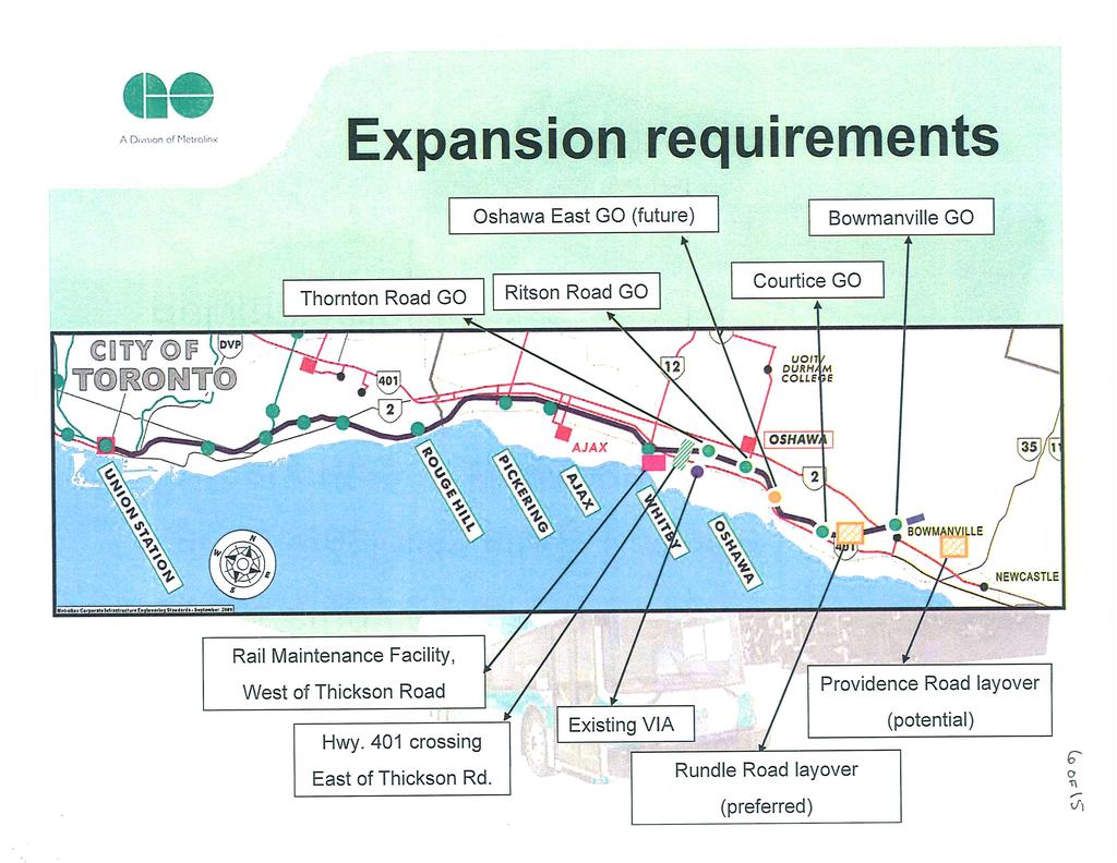
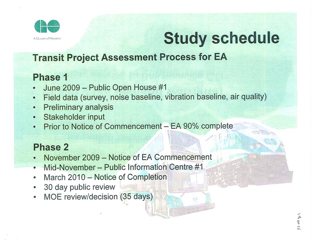
2 Report to: Council Report No.: PL Page 2 of BACKGROUND: GO Transit completed its feasibility study for extension of its commuter rail service to Bowmanville earlier this year. The study addressed the feasibility of the service extension and identified the CP Rail corridor as the preferred alignment. The study also identified potential station and lay-over sites. GO Transit also completed its feasibility study for the development of a heavy rail maintenance yard east of Union Station and concluded that lands in Whitby adjacent to the CN Rail/GO Transit corridor east and west of Hopkins Street to be the preferred location. The formal initiation of the EA process was September This process was established to fast track major transit projects. By this process, GO Transit within 120 days of the Notice of Commencement will file and publish the Notice of Completion. A 30 day public review period will then be provided for public comment. Following this period the study will be filed for review and decision by the Minister of Environment. The review period for the Minister is 35 days. The Transit Project Assessment process does not require GO Transit to consider any alternatives to the project over those identified in the feasibility study. Consultations were had with municipal staff prior to the publication of the report outlining the preferred routing for the extension and the location of the maintenance yard. Historically, discussions on the alignment spoke to the possible movement north to the CP Rail right-of-way wholly in Oshawa. Review of the April 23, 2009 contract document indicates that the suggestion for what is now the preferred alignment originated at a meeting held on October 17, 2008 with GO Transit and Region of Durham staff. There was no consultation with Whitby respecting the extensions in that the Whitby alignment had not been contemplated. There was no consultation with Whitby until after the publication of the document when Whitby Staff were advised that there was now a Whitby alignment and that it was the preferred alignment. 5.0 DISCUSSION/OPTIONS: PART A - EXTENSION OF GO RAIL TRANSIT WHITBY TO BOWMANVILLE Extension of the rail line into Bowmanville has been recommended by GO Transit to address existing and future projected ridership demand requirements. The ability to pursue this plan is now more definitive due to the funding commitment from MoveOntario The first phase of the expansion will provide a.m. and p.m. peak service to Bowmanville with the ultimate plan to have all day service when demand warrants.
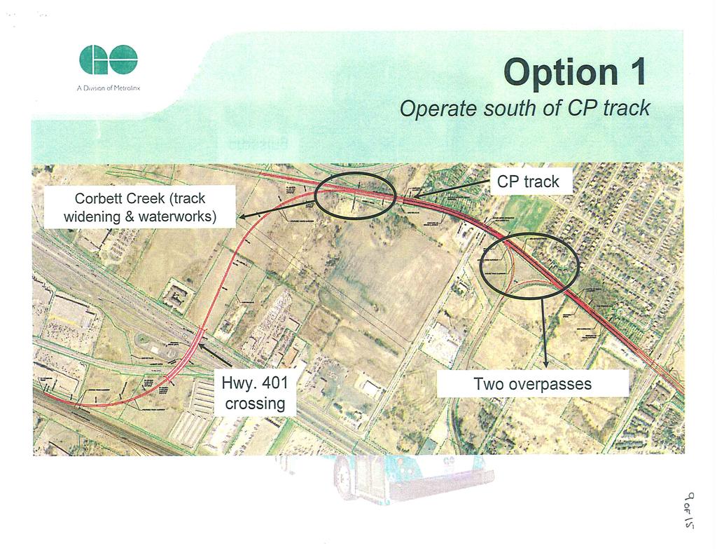
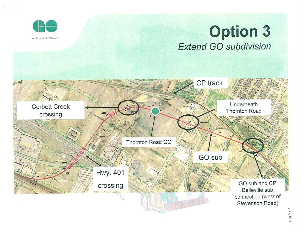
3 Report to: Council Report No.: PL Page 3 of 9 Various alignments on the CN and CP Rail corridors were reviewed as part of the feasibility assessment. As part of the EA Study, no additional alignments are being considered. PART B - THE PREFERRED WHITBY ALIGNMENT. The preferred alignment in the Town of Whitby extends north from the CN Rail/GO Transit corridor crossing over Highway 401 and Champlain Avenue to connect into the CP Rail corridor in the Corbett Creek valley. The alignment does not address the planned extension of Consumers Drive. The impacts on future widening of Highway 401 should also be considered. Replacement of the culverts under the CN Rail/GO Transit right-of-way may be required. Whitby Recommendations: 1. That master drainage plans associated with the proposed rail extension be completed and the need for improvements be identified. 2. That the preferred alignment only proceed once it has been demonstrated that the extension, along with the widening of Highway 401, will not adversely impact flood conditions to private properties and environmental features of the surrounding valley lands. 3. That the proposed extension within Whitby from the CN Rail corridor to the CP Rail corridor include grade separations at both the future extension of Consumers Drive and at the existing level crossing at Thornton Road. 4. That such studies assume the full widening of Highway 401. PART C - GO STATIONS ALTERNATIVE TO BE ASSESSED The station locations assessed by the report did not include any assessment of any station opportunities in Oshawa or Whitby west of Thornton Road. This is due to the fact that the study had historically never considered a Whitby alignment between the CN Rail/GO Transit corridor and the CP Rail corridor. Had Whitby known and been consulted, Staff would have had the opportunity to raise this matter and other observations prior to the release of the report. A station in this location would have immediate access to both Thickson and Thornton Roads. These two arterial roads are existing streets that extend north through the existing and planned urban areas; from Champlain Avenue to Highway 12 in the case of Thickson Road and to Myrtle Road in the case of Thornton Road. Both arterials are also planned to interchange with Highway 407. A station location in the area between the Consumers Drive extension and Thornton Road along the preferred alignment would appear to be more accessible and convenient to the Whitby and Oshawa population, whether travelling by car or future transit service. This possible location should be included in the assessment.
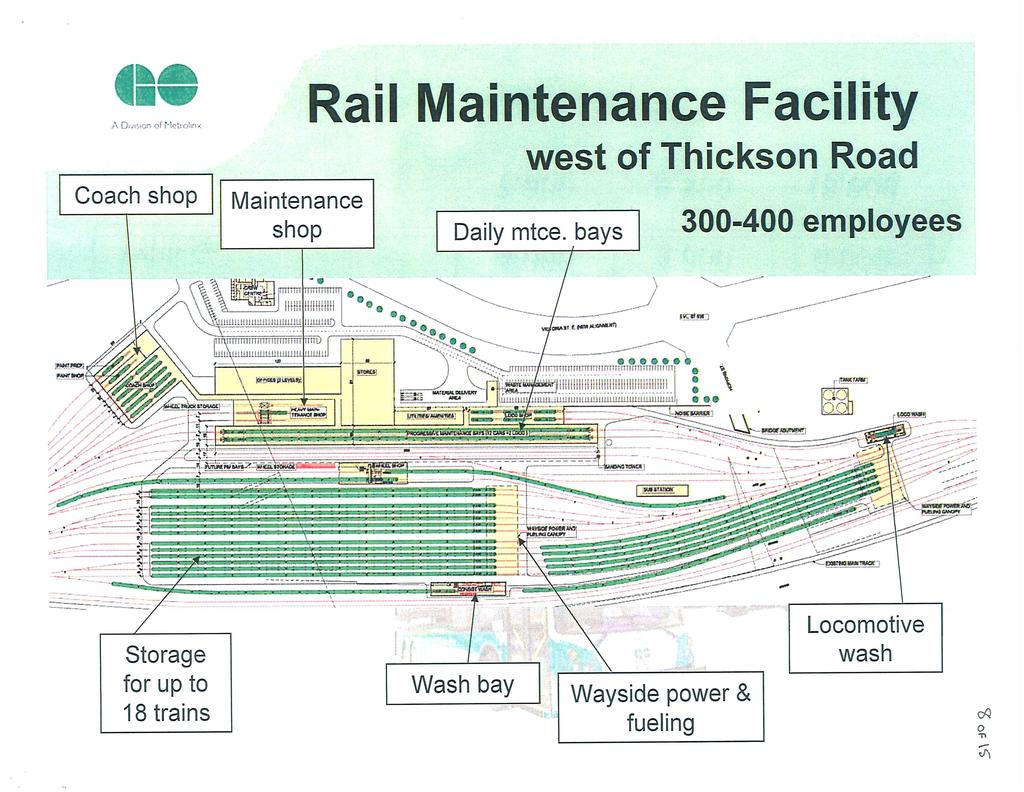
4 Report to: Council Report No.: PL Page 4 of 9 Whitby Recommendations: 1. That GO Transit s study include the examination of a future GO Station in the area west of Thornton Road in either or both Whitby and Oshawa; and 2. That the examination of a future station west of Thornton Road also include the impacts on drainage, as well as a transportation review of the impacts and requirements associated with access and the area road network. PART D - THE GO RAIL MAINTENANCE YARD The preferred location of the GO Transit rail maintenance yard is illustrated in Attachment #1. It is generally situated south of Victoria Street s planned re-alignment, adjacent to the CN Rail/GO Transit corridor east and west of Hopkins Street. Stormwater Management Storm water management plans will be required to control both quantity and quality during and after construction. On site containment areas may also be required to contain potential spills or leakage of contaminated liquids during emergency situations. Whitby Recommendations: 1. Updates to master drainage studies should be undertaken to ensure no net impacts to area properties and watersheds resulting from the proposal; and 2. Storm water and emergency management containment facility plans should be developed and implemented to the satisfaction of the Town of Whitby, CLOC and the MOEE. Town of Whitby Roads Hopkins Street Hopkins Street extends south of the CN Rail/GO Transit corridor and serves both Gerdau AmeriSteel and Hanson Pipe & Products. The proposed maintenance yard will require replacement of the existing overpass and realignment of Hopkins Street to accommodate the additional track lines on the GO Transit/CN Rail corridor. Hopkins Street is planned by the Region of Durham to span (flyover) Highway 401 and there are also plans to realign Victoria Street in the vicinity of the maintenance yard. The realignment is presently designed to accommodate the Highway 401 flyover. At present, Hopkins Street south of existing Victoria Street is under Town of Whitby jurisdiction. The replacement of the CN Rail/GO Transit overpass and roadway approaches are to be the full responsibility of GO Transit and should be designed so
5 Report to: Council Report No.: PL Page 5 of 9 as to accommodate the planned re-alignment of Victoria Street and Highway 401 flyover. To minimize disruption in the area, the realignment of Victoria Street should coincide with the construction of the new CN Rail grade separation and Hopkins Street road works and be completed prior to opening of the rail maintenance yard. Whitby Recommendations: 1. The replacement of the CN Rail overpass and reconstruction of Hopkins Street south of Victoria Street to the lands south of the CN Rail/GO Transit corridor be the sole responsibility of GO Transit and/or the CN Rail; and 2. That servicing agreements to address the matters of performance, maintenance and ownership of the road and for the bridge structure be entered into whereby the full ownership and maintenance of the bridge structure would be that of GO Transit and/or CN Rail. South Blair Street At present, the existing rail crossing at South Blair Street is at grade controlled by gates and bells. Rail traffic crossing this location are required to sound their whistle and over the years, the municipality has received numerous requests by nearby residents to implement an anti-whistle by-law. If this crossing was to remain at-grade, it is anticipated that the proposed maintenance facility and associated rail traffic would increase the whistle activity and concerns from area residents. As well, the exposure factor at the crossing would increase with the additional rail traffic and create additional delays and conflicts for commercial and employee vehicle trips destined to/from the employment area to the south. This matter has been discussed with GO Transit representatives and it has been stated to the Town that they will be constructing a grade separation (subway) structure and thus eliminating the at-grade crossing. The construction and maintenance cost of this structure should be the responsibility of GO Transit. With the proposed maintenance yard, a grade separation at this location is fundamental to ensure the safe and efficient movement of goods and materials from local businesses and residents, as well as pedestrian and recreational trips destined to Whitby s waterfront. The construction of a subway structure could take up to two years and have significant impact on access to area lands during that time. It is requested that as part of any temporary rail diversions, at-grade road diversions also be maintained to ensure access is provided. Other area road improvements (operational and physical) may be required during construction to safely accommodate heavy vehicles and other forms of traffic (e.g. signals at Victoria Street). This is important also from an emergency service perspective as there are limited access points to the industrial areas in this part of Port Whitby. As well, many residents in Port Whitby have expressed concerns with truck traffic on Brock Street and Watson Street (currently posted No Heavy
6 Report to: Council Report No.: PL Page 6 of 9 Trucks) and any increase associated with construction on these routes would create additional neighbourhood concerns. Whitby Recommendations: 1. That the improvements to construct a grade separation under the CN Rail/GO Transit corridor be endorsed provided that all costs associated with the approval, design and construction of the grade separation and approaches be the sole responsibility of GO Transit and that servicing agreements to address matters of performance, maintenance and ownership of the bridge structure be entered into whereby the full ownership and maintenance of the bridge structure would be that of GO Transit and/or CN Rail; and 2. That GO Transit provide during the construction of the South Blair Street grade separation the necessary at-grade road diversion on South Blair Street (or other acceptable alternate route not being Watson Street or Brock Street) to provide access to the industrial area. 6.0 PUBLIC COMMUNICATIONS/PLAN: Public notice of the proposed extension of GO Transit s rail service has in written text indicated that the project is to occur from the City of Oshawa to the area municipality of Clarington. While the map included the preferred alignment in the Town of Whitby the map was small and difficult to interpret and did not clearly define the proposed grade separation at South Blair Street. With the title given to the project, Whitby property owners may not have interpreted the alignment as being of interest. We suspect this occurred as the original options presented did not include an alignment in Whitby. Whitby Recommendations: 1. That future Public Notices title the project as being from the Town of Whitby to the area municipality of Clarington. It is Staff s understanding that communications respecting the preferred choices will be limited to those expressing interest and to those properties within 30 m of the GO s preferred alignment. The influence and impacts of this project will in staffs view extend beyond 30 meters. Staff recommend that the properties to be directly notified be within 120m of the planned alignment, to the industrial community off South Blair Street and within 120m of the rail alignment in the westerly approach to the maintenance yard. Whitby Recommendations: 1. That notification in the Town of Whitby be extended to all lands within 120 metres of the preferred alignment or maintenance yard and to all industrial properties on South Blair Street, Watson Street and Harbour Street.
7 Report to: Council Report No.: PL Page 7 of 9 2. That notification include all properties within 120 metres of the existing CN Rail/GO Transit alignment between South Blair Street and Brock Street. 7.0 CONSIDERATIONS: A. PUBLIC The subject project is a major investment in commuter rail service to the residents of Whitby, Oshawa, Clarington and beyond to maximize ridership. The GO Transit stations need to be situated in the best location to provide maximum access to the existing and future population. The inclusion of the preferred Whitby alignment provides the opportunity for a new station location west of Thornton Road. Such a location merits a full review and a comparative analysis to assess the merits as a potential station site. Works within the vicinity of the valley lands associated with the Pringle and Corbett Creeks need careful study so that the development of valuable employment lands are not adversely impacted and in a manner whereby the integrity of the valley lands and Corbett wetland are maintained. Habitat restoration and contributions to the valley land habitats on the Corbett Creek need to be explored and a restoration plan created and implemented. The new maintenance yard provides a valuable and needed service for GO Transit. New and modified roads, intersections and bridge structures, to accommodate the GO Transit facilities, should be at the full cost of GO Transit. Agreements regarding ownership of the bridge structures and responsibilities for maintenance and repair need to be developed. The movement of goods and materials, logistic vehicles and employee vehicles to and from the employment areas south of Highway 401 must be maintained even during construction. While fully supporting the need for GO Transit s construction of an underpass at the CN Rail/GO Transit corridor at South Blair Street, the diversion of the vehicles destined to and from this industrial area needs a properly designed access route that will not jeopardize the timely movement of goods and materials to and from the industrial area in a manner that does not traverse a residential community. B. FINANCIAL N/A C. IMPACT ON & INPUT FROM OTHER DEPARTMENTS/SOURCES The projects should they be advanced as contemplated will require the consideration and input of all departments.
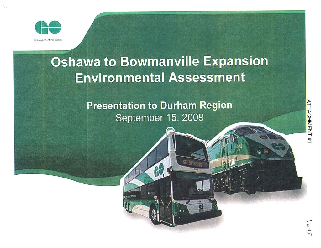
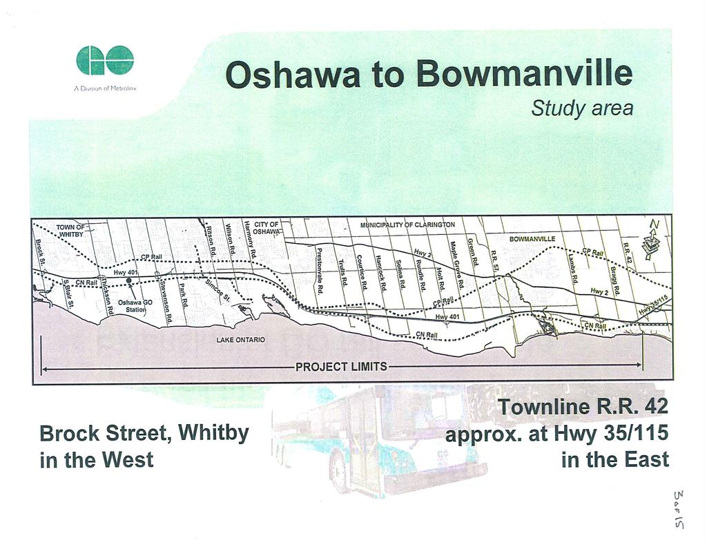
8 Report to: Council Report No.: PL Page 8 of 9 D. CORPORATE AND/OR DEPARTMENT STRATEGIC PRIORITIES The subject development project is permitted by both the Whitby and the Durham Region Official Plans. The project provides for increased transit service to the Durham Region and to the residents of the Town of Whitby. The maintenance yard will secure some new jobs in the Town of Whitby; jobs that are needed to sustain the operations of GO Transit s fleet. The maintenance yard is considered to be a secure long term employer. The investment will strengthen Whitby s industrial community and the service industry. The maintenance yard is compatible with the heavy industrial uses south of the CN Rail/GO Transit corridor, and will be sheltered by intervening development between the yard by office facilities and other industrial/commercial development. 8.0 SUMMARY AND CONCLUSION That Report PL be forwarded to GO Transit and the chief consultant of this project, the Region of Durham, and the Minster of Environment. 9.0 ATTACHMENTS Attachment #1: Go Transit - Oshawa to Bowmanville Expansion Environmental Assessment, Presentation to Durham Region September 15, 2009 (Note: The Presentation document, as attached, has been modified to include a potential station location west of Thornton Road)
9 Report to: Council Report No.: PL Page 9 of 9 For further information contact: Robert B. Short, Ext / Suzanne Beale, Ext Robert B. Short, Director of Planning, Ext Suzanne Beale, Director of Public Works, Ext Robert Petrie, Chief Administrative Officer, Ext. 2211
10
11
12
13
14
15
16
17
18
19
20
21
22
23
24
Services Department B September 10, 2007
 Report To: Development Services Committee Item: Date of Report: DS-07-246 September 5, 2007 From: Commissioner, Development File: Date of Meeting: Services Department B7200-0001 September 10, 2007 Subject:
9 CITY OF VAUGHAN OFFICIAL PLAN AMENDMENT NO BOCA EAST INVESTMENTS LIMITED
 9 CITY OF VAUGHAN OFFICIAL PLAN AMENDMENT NO. 631 - BOCA EAST INVESTMENTS LIMITED The Planning and Economic Development Committee recommends the adoption of the recommendations contained in the following
AGINCOURT SECONDARY PLAN
 1 AGINCOURT SECONDARY PLAN 1. AGINCOURT SECONDARY PLAN The following policies and principles apply to the area herein referred to as Agincourt, as outlined on Map 1-1. 1. GENERAL POLICIES 1.1 This Secondary
COUNCIL ATTACHMENT 2 HIGHWAY 7 CORRIDOR AND VAUGHAN NORTH-SOUTH LINK
 COUNCIL ATTACHMENT 2 HIGHWAY 7 CORRIDOR AND VAUGHAN NORTH-SOUTH LINK Welcome! The purpose today is to: Present the Study Background; Describe Alignment Alternatives Analyzed; Present the Evaluation of
Second Line West Pedestrian/Cyclist Crossing of Highway 401 Class EA. Second Line West Pedestrian/Cyclist Crossing of Highway 401 Class EA
 1 1 Purpose of Public Information Centre #2 To provide interested and/or potentially affected stakeholders with an opportunity to participate in the planning and decision-making process for this Municipal
Services Department F May 28, 2007
 Report To: Development Services Committee Item: Date of Report: From: DS-07-144 May 23, 2007 Commissioner, Development File: Date of Meeting: Services Department F-7000-0013 May 28, 2007 Subject: Gibb
PORT WHITBY COMMUNITY
 PORT WHITBY COMMUNITY SECONDARY PLAN UPDATE COMMUNITY IMPROVEMENT PLAN URBAN DESIGN GUIDELINES September 2015 DRAFT PROPOSED AMENDMENT NUMBER # to the Whitby Official Plan PURPOSE: The intent of this Amendment
WELCOME TO OPEN HOUSE TWO November 28, 2018
 Langstaff Road Weston Road to Highway 7 Class Environmental Assessment Study WELCOME TO OPEN HOUSE TWO November 28, 2018 Please sign in and join our mailing list Study Overview York Region is conducting
The Corporation of the Town of Milton
 Report To: From: Council Barbara Koopmans, Commissioner, Planning and Development Date: May 7, 2018 Report No: Subject: Making it Possible Positioning the Town s Strategy for Growth and Economic Development
Introduction. Public Information Package. Project website. Overview. Class Environmental Assessment Process
 1 Introduction Public Information Package Baseline Road Extension between Lambs Road and Bennett Road, Bowmanville Schedule B Municipal Class Environmental Assessment November 6, 2017 Overview The purpose
Public Information Centre #1
 and Highway 401 Interchange Improvements WELCOME Public Information Centre #1 Veterans Memorial Parkway Extension and Highway 401 Interchange Improvements Study May 23, 2012 4 p.m. to 7 p.m. Brief Overview
Eglinton West LRT Update
 Eglinton West LRT Update Community Consultation Update May 16, 2016 Background Rapid transit along Eglinton Ave between Kennedy Station and Pearson Airport was included in the Metrolinx Regional Transportation
Relief Line Project Assessment
 Relief Line Project Assessment Public Information Centre April 5, 2017 Tonight s Meeting PURPOSE To review the preferred alignment for the Local Segment. AGENDA 6:30 Open House 7:00 Presentation / Discussion
Summary of Changes for the Comprehensive Draft Proposed Official Plan Amendment
 Summary of Changes for the Comprehensive Draft Proposed Official Plan Amendment Note: Due to the broad scope of the Official Plan Review, this list is not exhaustive of the extent of changes in the comprehensive
SCARBOROUGH SUBWAY EXTENSION. Scarborough Subway Extension. Final Terms of Reference
 Scarborough Subway Extension Final Terms of Reference 1 1.0 Introduction and Background 1.1 Introduction Toronto City Council recently confirmed support for an extension of the Bloor-Danforth Subway from
Mavis Road Class Environmental Assessment
 Mavis Road Class Environmental Assessment Public Information Centre #2 Wednesday November 9, 2016 6:00 to 8:00 p.m. Please sign in and complete a comment sheet Review the displays on your own or join in
3 MARKHAM NORTH-SOUTH LINK CORRIDOR PUBLIC TRANSIT IMPROVEMENTS ENVIRONMENTAL ASSESSMENT UPDATE
 3 MARKHAM NORTH-SOUTH LINK CORRIDOR PUBLIC TRANSIT IMPROVEMENTS ENVIRONMENTAL ASSESSMENT UPDATE The Rapid Transit Public/Private Partnership Steering Committee recommends the adoption of the recommendations
CITY OF VAUGHAN EXTRACT FROM COUNCIL MEETING MINUTES OF JUNE 7, 2016
 Item 5, Report No. 26, of the Committee of the Whole (Working Session), which was adopted without amendment by the Council of the City of Vaughan on June 7, 2016. 5 MUNICIPAL CLASS ENVIRONMENTAL ASSESSMENT
Parks Master Plan Implementation: Phase I Waterfront Use and Design REPORT #: September 7, 2016 File #
 0 'O DI Lan-171-14 1 - THE CORPORATION OF THE TOWN OF COBOURG..,. STAFF REPORT TO: FROM: Mayor and Members of Council Dean A. Hustwick, Director of Recreation and Culture DATE OF MEETING: Committee of
Strachan Ave. Overpass Community Design Update. October 26, 2010 Stephen Lipkus Executive Director Georgetown South Project GO Transit
 Strachan Ave. Overpass Community Design Update October 26, 2010 Stephen Lipkus Executive Director Georgetown South Project GO Transit Welcome Program Overview 6:30 8:30 p.m.: Storyboard Review Project
Public Meeting #3 May 9, 2009 MVVA Team
 Public Meeting #3 May 9, 2009 MVVA Team Welcome to the third Public Meeting for the Lower Don Lands Municipal Class Environmental Assessment (EA) Infrastructure Master Plan and Keating Channel Precinct
Purpose of Open House #3
 Public Meeting #3 May 9, 2009 MVVA Team Purpose of Open House #3 The main purpose of this Open House is to present and seek input on the: Evaluation of transportation and infrastructure design alternatives
Emery Village Road 2A Municipal Class Environmental Assessment Study
 PW12.11 STAFF REPORT ACTION REQUIRED Emery Village Road 2A Municipal Class Environmental Assessment Study Date: March 30, 2016 To: From: Wards: Reference Number: Public Works and Infrastructure Committee
Municipal Heritage Bridges Cultural, Heritage and Archaeological Resources Assessment Checklist Revised April 11, 2014
 Municipal Heritage Bridges Cultural, Heritage and Archaeological Assessment Checklist Revised April 11, 2014 This checklist was prepared in March 2013 by the Municipal Engineers Association to assist with
Southeast Extension to RidgeGate Parkway Scoping Booklet
 Southeast Extension to RidgeGate Parkway Scoping Booklet PUBLIC SCOPING MEETING SCHEDULE Public Scoping Meeting Wednesday, November 2, 2011 6:00pm to 7:30pm City of Lone Tree Recreation Center Willow Room
CHAPTER 7: Transportation, Mobility and Circulation
 AGLE AREA COMMUNITY Plan CHAPTER 7 CHAPTER 7: Transportation, Mobility and Circulation Transportation, Mobility and Circulation The purpose of the Transportation, Mobility and Circulation Chapter is to
Burloak Drive Grade Separation
 Burloak Drive Grade Separation Transit Project Assessment Process Public Meeting #1 March 30, 2017 GO Lakeshore West Service Plan Weekday Rush Hour 15-minute, two-way service between Aldershot* and Union
Getting and Giving the Most
 Getting and Giving the Most It s OUR meeting participate enthusiastically Focus on the future Terminology expertise is secondary There is such a thing as a bad idea! Respect (for each other and the process)
City of Toronto. Emery Village Transportation Master Plan
 City of Toronto Emery Village Transportation Master Plan May 2009 Emery Village Transportation Master Plan Toronto, ON May 2009 Consulting Inc. 100 York Blvd., Suite 300 Richmond Hill, ON L4B 1J8 Tel:
Edward R. Sajecki Commissioner of Planning and Building. Land Use Review- Former Parkway Belt West Lands- Fieldgate Drive and Audubon Boulevard
 Corporate Report Clerk s Files Originator s Files CD.04.FOR DATE: November 15, 2011 TO: FROM: SUBJECT: Chair and Members of Planning and Development Committee Meeting Date: December 5, 2011 Edward R. Sajecki
Heritage Road Improvements from Steeles Avenue to Rivermont Road
 The Corporation of the City of Brampton Heritage Road Improvements from Steeles Avenue to Rivermont Road Class Environmental Assessment Study (Schedule C) September 19, 2013 The Corporation of the City
Better Cycling. The City will update the cycling master plan (London ON Bikes) based on the approved BRT network.
 based on the approved BRT network.") Better Cycling Dedicated bike facilities will be constructed along BRT corridors where space is available. Nearby bike routes will also be upgraded to ensure a complete network is available for cyclists.
Better Cycling Dedicated bike facilities will be constructed along BRT corridors where space is available. Nearby bike routes will also be upgraded to ensure a complete network is available for cyclists.
ARLINGTON COUNTY, VIRGINIA. County Board Agenda Item Meeting of January 28, 2017 SUPPLEMENTAL REPORT-2
 ARLINGTON COUNTY, VIRGINIA County Board Agenda Item Meeting of January 28, 2017 SUPPLEMENTAL REPORT-2 DATE: January 27, 2017 SUBJECT: The Virginia Department of Transportation s Transform I-66 Inside the
12 AMENDMENT NO. 149, TOWN OF MARKHAM HIGHWAY 404 NORTH SECONDARY PLAN
 12 AMENDMENT NO. 149, TOWN OF MARKHAM HIGHWAY 404 NORTH SECONDARY PLAN The Planning and Economic Development Committee recommends the adoption of the recommendation contained in the following report August
Central Lake Ontario Conservation Conservation Lands Master Plan
 Conservation Lands Master Plan Top 13 Frequently Asked Questions 1. What are conservation lands? Where are these conservation lands located in the Central Lake Ontario Conservation watershed? Conservation
WELCOME TO OPEN HOUSE # 3
 Bayview Avenue Class Environmental Assessment Study Steeles Avenue to Elgin Mills Road WELCOME TO OPEN HOUSE # 3 Please sign in and join our mailing list Why Are We Here Tonight? Study Process and Purpose
Shift Rapid Transit Public Participation Meeting May 3, 2017
 Shift Rapid Transit Public Participation Meeting May 3, 2017 Shift Rapid Transit Initiative Largest infrastructure project in the city s history. Rapid Transit initiative will transform London s public
BACKGROUND, GOALS, STUDY AREA, EVALUATION CRITERIA, ORGANIZATION
 CHAPTER 1 BACKGROUND, GOALS, STUDY AREA, EVALUATION CRITERIA, ORGANIZATION 1.0 INTRODUCTION The Executive Office of Transportation and Public Works Office of Transportation Planning (Planning) initiated
THE CORPORATION OF THE TOWN OF OAKVILLE BY-LAW NUMBER
 THE CORPORATION OF THE TOWN OF OAKVILLE BY-LAW NUMBER 20012-08530 A by-law to adopt an amendment to the Official Plan of the Oakville Planning Area (Official Plan Amendment 198) Land North of Dundas Street.
CITY COUNCIL AGENDA REPORT
 CITY COUNCIL AGENDA REPORT Subject: COUNCIL MOTION LRT ALIGNMENT REMOVAL FROM THE TRANSPORTATION MASTER PLAN On February 10, 2016 Councillor Hughes provided notice in accordance with Section 23 of Procedure
CITY OF VAUGHAN EXTRACT FROM COUNCIL MEETING MINUTES OF NOVEMBER 15, 2016
 Item 11, Report No. 38, of the Committee of the Whole, which was adopted without amendment by the Council of the City of Vaughan on November 15, 2016. Regional Councillor Di Biase declared an interest
Regional Context Statement
 Regional Context Statement REGIONAL CONTEXT STATEMENT 3. REGIONAL CONTEXT STATEMENT In 1995, the Provincial Government passed into law the Growth Strategies Act. The purpose of this provincial initiative
Bostwick Road. Municipal Class Environmental Assessment. October 13, City of London. Bostwick Road Municipal Class Environmental Assessment
 Bostwick Road Municipal Class Environmental Assessment October 13, 2016 Welcome! Welcome to the first Public Information Centre for the Bostwick Road Municipal Class Environmental Assessment. Representatives
ARLINGTON COUNTY, VIRGINIA. County Board Agenda Item Meeting of January 28, 2017 SUPPLEMENTAL REPORT
 ARLINGTON COUNTY, VIRGINIA County Board Agenda Item Meeting of January 28, 2017 SUPPLEMENTAL REPORT DATE: January 26, 2017 SUBJECT: The Virginia Department of Transportation s Transform I-66 Inside the
1.0 INTRODUCTION AND BACKGROUND
 1.0 INTRODUCTION AND BACKGROUND 1.1 INTRODUCTION / BACKGROUND The Regional Municipality of York (hereafter referred to as York Region ) has completed a Municipal Class Environmental Assessment (Class EA)
St. Clair Avenue West Area Transportation Master Plan
 1 (Between Keele Street and Old Weston Road) Public Information Centre 1 December 2, 2015 2 Welcome Welcome to the first Public Information Centre for the St. Clair Avenue West Area. The panels will present
The West Vaughan Employment Area Secondary Plan Policies
 Part 2: The West Vaughan Employment Area Secondary Plan Policies 2.1 General Policies It is the policy of Council: 2.1.1. That the West Vaughan Employment Area (the WVEA), identified on Schedule 1, will
6 Growth Management Challenges and Opportunities
 6 Growth Management Challenges and Opportunities The Town has established a goal of attaining a 50% participation rate with respect to employment opportunities versus residential population. The Town s
1.1.1 Growth Plan for the Greater Golden Horseshoe 2006 Office Consolidation January 2012
 HDR Corporation 100 York Blvd. Suite 300 Richmond Hill, ON L4B 1J8 Tel: (905) 882-4100 Fax: (905) 882-1557 www.hdrinc.com File: 2.0 Memorandum To: Amber Parnell Town of Innisfil Cc: From: Carl Wong - HDR
TRANSPORTATION COMMITTEE
 TRANSPORTATION COMMITTEE CITY OF OTTAWA Ministry of Transportation Detailed Design Assignment G.W.P.# 4058-01-00 Highway 417 (Ottawa Queensway) Widening & Rehabilitation from Maitland Avenue to Island
Northeast Corner of Steeles Avenue West and Jane Street, City of Vaughan
 STAFF REPORT ACTION REQUIRED Northeast Corner of Steeles Avenue West and Jane Street, City of Vaughan Date: June 1, 2010 To: From: Wards: Reference Number: North York Community Council Director, Community
Paul D. Ralph, BES, RPP, MCIP, Commissioner, Development Services Department. Proposed Storm Water Pond Maintenance Fee
 Public Report To: From: Report Number: Development Services Committee Paul D. Ralph, BES, RPP, MCIP, Commissioner, Development Services Department DS-16-211 Date of Report: December 1, 2016 Date of Meeting:
HURON COMMUNITY PLAN
 CITY OF KITCHENER DEPARTMENT OF DEVELOPMENT AND TECHNICAL SERVICES PD 94/7 HURON COMMUNITY PLAN Recommended by Planning and Economic Development Committee: October 31, 1994 Adopted by Kitchener City Council:
Vaughan Metropolitan Centre (VMC) Black Creek Renewal CLASS ENVIRONMENTAL ASSESSMENT
 Black Creek Renewal CLASS ENVIRONMENTAL ASSESSMENT") PUBLIC INFORMATION CENTRE Vaughan Metropolitan Centre (VMC) Black Creek Renewal Wednesday, May 10, 2017 6:00 p.m. to 8:00 p.m. Add photo Project Management, Environmental Assessment, Stormwater Management
PUBLIC INFORMATION CENTRE Vaughan Metropolitan Centre (VMC) Black Creek Renewal Wednesday, May 10, 2017 6:00 p.m. to 8:00 p.m. Add photo Project Management, Environmental Assessment, Stormwater Management
Committee of the Whole (Public Hearing) Report
 Report") Item:1 Committee of the Whole (Public Hearing) Report DATE: Tuesday, June 05, 2018 WARD: 2 TITLE: OFFICIAL PLAN AMENDMENT FILE OP.17.016 ZONING BY-LAW AMENDMENT FILE Z.17.046 IMPORTANNE MARKETING INC.
Item:1 Committee of the Whole (Public Hearing) Report DATE: Tuesday, June 05, 2018 WARD: 2 TITLE: OFFICIAL PLAN AMENDMENT FILE OP.17.016 ZONING BY-LAW AMENDMENT FILE Z.17.046 IMPORTANNE MARKETING INC.
THAT the attached Terms of Reference for the Thornhill Centre Street Study be approved.
 COMMITTEE OF THE WHOLE AUGUST 18, 2003 THORNHILL CENTRE STREET STUDY PLANNING FILE: 15.92 Recommendation The Commissioner of Planning recommends: THAT the attached Terms of Reference for the Thornhill
Rapid Transit Implementation Working Group September 14, 2017
 Rapid Transit Implementation Working Group September 14, 2017 BACKGROUND Council approved the Rapid Transit Master Plan and Updated Business Case on July 25, 2017. Approval of the RTMP confirmed the BRT
AMENDMENT NO. 30 TO THE OFFICIAL PLAN OF THE TOWN OF MILTON
 AMENDMENT NO. 30 TO THE OFFICIAL PLAN OF THE TOWN OF MILTON Subject: Boyne Survey Secondary Plan and Related Official Plan Amendments The following text and schedules constitute Amendment No. 30 to the
Planning Services Public Meeting Report
 Planning Services Public Meeting Report If this information is required in an alternate accessible format, please contact the Accessibility Coordinator at 905-623-3379 ext. 2131. Report To: Planning and
PROJECT STATEMENT LOCATION/DESIGN PUBLIC HEARING. 19 th AVENUE NORTH EXTENSION PROJECT FROM SPRINGDALE DRIVE TO NORTH 2 ND STREET/U.S.
 PROJECT STATEMENT LOCATION/DESIGN PUBLIC HEARING 19 th AVENUE NORTH EXTENSION PROJECT FROM SPRINGDALE DRIVE TO NORTH 2 ND STREET/U.S. 67 HEARING LOCATION: ERICKSEN COMMUNITY CENTER 1401 11 TH AVENUE NORTH
SPECIAL COMMITTEE OF THE WHOLE DECEMBER 9, 2002 BLOCK 57/58 WEST BLOCK PLAN BLOCK PLAN FILE BL.57/58W.99 HUNTINGTON BUSINESS PARK LAND OWNERS
 SPECIAL COMMITTEE OF THE WHOLE DECEMBER 9, 2002 BLOCK 57/58 WEST BLOCK PLAN BLOCK PLAN FILE BL.57/58W.99 HUNTINGTON BUSINESS PARK LAND OWNERS Recommendation The Commissioner of Planning recommends: THAT
6:00 8:00 PM I-95 FROM EXIT 57 TO EXIT 60 PROJECT
 PUBLIC INFORMATIONAL MEETING TUESDAY, APRIL 27, 2010 AT NEWBURYPORT CITY HALL, AUDITORIUM 60 PLEASANT STREET NEWBURYPORT, MASSACHUSETTS 6:00 8:00 PM FOR THE PROPOSED WHITTIER BRIDGE / I-95 IMPROVEMENTS
CITY OF VAUGHAN D R A F T YONGE STREET STUDY. June 2008 YOUNG + WRIGHT /IBI GROUP ARCHITECTS DILLON CONSULTING LTD.
 CITY OF VAUGHAN June 2008 YOUNG + WRIGHT /IBI GROUP ARCHITECTS GHK SUSTAINABILITY INTERNATIONAL + LIVABILITY (CANADA) LTD. = COMMUNITY VALUE DILLON CONSULTING LTD. Public Open House Tonight s Meeting WELCOME
CITY OF VAUGHAN EXTRACT FROM COUNCIL MEETING MINUTES OF MAY 27, 2014
 CITY OF VAUGHAN EXTRACT FROM COUNCIL MEETING MINUTES OF MAY 27, 2014 Item 6, Report No. 21, of the Committee of the Whole, which was adopted without amendment by the Council of the City of Vaughan on May
South of Eastern Strategic Direction Status Update
 STAFF REPORT ACTION REQUIRED South of Eastern Strategic Direction Status Update Date: July 10, 2014 To: From: Planning and Growth Management Committee Chief Planner and Executive Director, City Planning
3. Endorse the LRT vision in transforming Surrey into Connected-Complete-Livable communities, and more specifically, the official vision statement:
 CORPORATE REPORT NO: R038 COUNCIL DATE: February 20, 2017 REGULAR COUNCIL TO: Mayor & Council DATE: February 16, 2017 FROM: General Manager, Engineering FILE: 8740-01 SUBJECT: Surrey Light Rail Transit
NORTHEAST RIVER CROSSING FUNCTIONAL PLANNING STUDY
 WELCOME Northeast River Crossing Functional Planning Study Phase 2 Public Meeting 4 to 8 PM Informal drop-in format and discussion tables Meeting Purpose Introduce the Northeast River Crossing Functional
Master Environmental Servicing Plan & Secondary Plan
 1 East Side Lands Stage 2 Master Environmental Servicing Plan & Secondary Plan Public Consultation Centre #4 March 20, 2018 Welcome! Today s Agenda Please sign in at the registration table. 6:00 pm 6:30
Goals for Tonight s Meeting
 South Anthony Boulevard Railroad Grade Separation Study Report to Community November 30, 2011 Andorfer Commons Theatre Indiana Tech University Goals for Tonight s Meeting Recap of the meeting from last
STAFF REPORT TO COUNCIL PLANNING AND DEVELOPMENT
 DATE: April 29, 2013 STAFF REPORT TO COUNCIL PLANNING AND DEVELOPMENT 1100 Patricia Boulevard, Prince George, B.C., V2L 3V9 TO: FROM: SUBJECT: MAYOR AND COUNCIL JESSE DILL, PLANNER Development Variance
5 TOWN OF MARKHAM OFFICIAL PLAN AMENDMENT NO. 144 MILLIKEN MAIN STREET SECONDARY PLAN
 5 TOWN OF MARKHAM OFFICIAL PLAN AMENDMENT NO. 144 MILLIKEN MAIN STREET SECONDARY PLAN The Planning and Economic Development Committee recommends the following: 1. The communication from Brendan O Callaghan,
FORMER CANADIAN FORCES BASE (CFB) ROCKCLIFFE SECONDARY PLAN. Official Plan Amendment XX to the Official Plan for the City of Ottawa
 ROCKCLIFFE SECONDARY PLAN. Official Plan Amendment XX to the Official Plan for the City of Ottawa") FORMER CANADIAN FORCES BASE (CFB) ROCKCLIFFE SECONDARY PLAN Official Plan Amendment XX to the Official Plan for the City of Ottawa 1 INDEX THE STATEMENT OF COMPONENTS PART A THE PREAMBLE PAGE Purpose...
FORMER CANADIAN FORCES BASE (CFB) ROCKCLIFFE SECONDARY PLAN Official Plan Amendment XX to the Official Plan for the City of Ottawa 1 INDEX THE STATEMENT OF COMPONENTS PART A THE PREAMBLE PAGE Purpose...
Report to: Development Services Committee Report Date: September 11, 2017
 ~RKHAM Report to: Development Services Committee Report Date: September 11, 2017 SUBJECT: PREPARED BY: Conceptual Master Plan for the Future Urban Area - Community Structure Plan and Key Policy Direction
The Illinois Department of Transportation and Lake County Division of Transportation. Route 173, including the Millburn Bypass
 The Illinois Department of Transportation and Lake County Division of Transportation welcome you to this Public Hearing for U.S. Route 45 from Illinois Route 132 to Illinois Route 173, including the Millburn
CHARLES PUTMAN CHARLES PUTMAN AND ASSOCIATES, INC
 MEMORANDUM CHARLES PUTMAN & ASSOCIATES, INC. LAND DEVELOPMENT CONSULTANTS PLANNING ZONING PERMITTING 4722 NW Boca Raton Boulevard, Suite C-106 Boca Raton, Florida 33431 Phone: 561/994-6411 FAX: 561/994-0447
3 Development Process 3.1 Stage One page Stage Two page Stage Three page CENTRAL PICKERING DEVELOPMENT PLAN
 3 Development Process 3.1 Stage One page 24 3.2 Stage Two page 25 3.3 Stage Three page 28 22 CENTRAL PICKERING DEVELOPMENT PLAN The Central Pickering Development Plan establishes the key elements of new
TABLE OF CONTENTS. Sierra Springs Outline Plan
 Sierra Springs Outline Plan TABLE OF CONTENTS 1. Introduction...3 1.1. Purpose of the Plan... 3 1.2. The Approval Process... 3 1.3. Policy and Legislative Framework... 3 2. Development Area...6 2.1. Location
SECTION 4(f) DE MINIMIS DOCUMENTATION
 DE MINIMIS DOCUMENTATION") SECTION 4(f) DE MINIMIS DOCUMENTATION Illinois Route 60/83 IL 176 to the intersection of IL 60 (Townline Road) Lake County P-91-084-07 Mundelein Park and Recreation District Project Limit SECTION 4(f)
SECTION 4(f) DE MINIMIS DOCUMENTATION Illinois Route 60/83 IL 176 to the intersection of IL 60 (Townline Road) Lake County P-91-084-07 Mundelein Park and Recreation District Project Limit SECTION 4(f)
Coordinated Transit Planning in Toronto SmartTrack GO RER Scarborough Relief Line Waterfront Transit
 Coordinated Transit Planning in Toronto SmartTrack GO RER Scarborough Relief Line Waterfront Transit Public Information Centres February 2016 Transportation Planning Section City Planning Division Toronto
Edward R. Sajecki Commissioner of Planning and Building. Region of Halton Proposed Regional Official Plan Amendment for 5768 Ninth Line
 Corporate Report Clerk s Files Originator s Files MG.11.MIL DATE: TO: FROM: SUBJECT: Chair and Members of Planning and Development Committee Meeting Date: April 3, 2006 Edward R. Sajecki Commissioner of
Meeting Purpose: Date and Time: Location: Attendance: Handouts:
 Meeting Purpose: Date and Time: Location: Attendance: Handouts: PA Turnpike / I-95 Interchange Project Design Advisory Committee (DAC)/Public Officials Meeting #8 April 12, 2012 at 1:30 p.m. Project Office,
THE MINISTRY OF TRANSPORTATION S SUMBISSION FOR THE
 THE MINISTRY OF TRANSPORTATION S SUMBISSION FOR THE 2011 Transportation of Canada Environmental Achievement Awards 407 East Environmental Assessment Stakeholder Consultation Process / Community Value Plan
OTC ENVIRONMENTAL ASSESSMENT WORKSHOP
 OTC ENVIRONMENTAL ASSESSMENT WORKSHOP JULY 18, 2018 Black Creek Pioneer Village 1000 Murray Ross Pkwy North York, ON Register online at: www.otc.org/events Ontario Traffic Council 204-47 Colborne St.,
Portage Parkway Environmental Assessment Public Information Centre No. 1
 City of Vaughan Portage Parkway Environmental Assessment Public Information Centre No. 1 November 25, 2015 Welcome to the Public Information Centre This first Public Information Centre (PIC) introduces
Welcome. Northern Segment of Hwy 100 I-90 to South of Madison Street Meeting Goals:
 Welcome Northern Segment of Hwy 100 I-90 to South of Madison Street Meeting Goals: - Review Environmental Assessment - Share Preferred Alternative -Receive Public Comments 2003 EA Preferred Alternative
Building the transportation network we need for the future
 Building the transportation network we need for the future WHO IS METROLINX? Metrolinx was created in 2006 by the Province of Ontario with a mandate to create greater connection between the communities
East Corridor Final Environmental Impact Statement
 East Corridor Final Environmental Impact Statement Alternatives Considered Operating Plan The requirements for opening day operations versus year 2030 are based on ridership and operations. Opening day
Employment and Commercial Review Analysis of Policy Directions
 Employment and Commercial Review Analysis of Policy Directions Appendix A The following analysis is town staff s response to the policy directions provided by the consultants who prepared the Employment
North Oakville East Parks Facilities Distribution Plan. November, 2009
 North Oakville East November, 2009 POLICY CONTEXT 1) Purpose a) The purpose of this document is to be a guide for the location, configuration, design and development of the parks system for the North Oakville
The Regional Municipality of Halton. Chair and Members of the Planning and Public Works Committee
 The Regional Municipality of Halton Report To: From: Chair and Members of the Planning and Public Works Committee Art Zuidema, Commissioner, Legislative and Planning Services Date: October 4, 2017 Report
Foster Creek West Clarington, Ontario PLANNING JUSTIFICATION REPORT
 Foster Creek West Clarington, Ontario PLANNING JUSTIFICATION REPORT Official Plan Amendment Zoning By-law Amendment Neighbourhood Design Plan Amendment Draft Plan of Subdivision File No. 112092 February
SUBJECT: GO Station Mobility Hubs Preferred Concepts: Aldershot GO, Burlington GO and Appleby GO. Planning and Development Committee - Public Meeting
 Page 1 of Report PB-76-17 SUBJECT: GO Station Mobility Hubs Preferred Concepts: Aldershot GO, Burlington GO and Appleby GO TO: FROM: Planning and Development Committee - Public Meeting Planning and Building
The Commissioner of Engineering and Public Works, the Director of Public Works and the Director of Development / Transportation Engineering recommend:
 COMMITTEE OF THE WHOLE JUNE 16, 2008 WATER FOUNTAINS AND AERATION DEVICES IN STORM WATER MANAGEMENT FACILITIES Recommendations The Commissioner of Engineering and Public Works, the Director of Public Works
Bostwick Road. Municipal Class Environmental Assessment. Public Information Centre #2 June 14, City of London
 Bostwick Road Municipal Class Environmental Assessment Public Information Centre #2 June 14, 2017 Welcome! Welcome to the 2 nd Public Information Centre for the. Representatives from the and the consulting
TO: Mayor & Council DATE: April 12, The Planning and Development Department and the Engineering Department recommend that Council:
 CORPORATE REPORT NO: R080 COUNCIL DATE: April 12, 2010 REGULAR COUNCIL TO: Mayor & Council DATE: April 12, 2010 FROM: SUBJECT: General Manager, Planning and Development General Manager, Engineering Neighbourhood
John M. Fleming Managing Director, Planning and City Planner. Old East Village Dundas Street Corridor Secondary Plan Draft Terms of Reference
 Report to Planning and Environment Committee To: From: Subject: Chair and Members Planning & Environment Committee John M. Fleming Managing Director, Planning and City Planner Old East Village Dundas Street
Humber Bay Shores Precinct Plan Final Report
 STAFF REPORT ACTION REQUIRED Humber Bay Shores Precinct Plan Final Report Date: May 21, 2010 To: From: Wards: Reference Number: Etobicoke York Community Council Director, Community Planning, Etobicoke
Port Credit Local Advisory Panel October 20 th Meeting
 Port Credit Local Advisory Panel October 20 th Meeting Focus Of This Evening s Meeting: 1. Hurontario Main Street Higher Order Transit Study 2. Port Credit Mobility Hub & GO Station Parking Structure Study
RESOLUTION NO. R Refining the route, profile and stations for the Downtown Redmond Link Extension
 RESOLUTION NO. R2018-32 Refining the route, profile and stations for the Downtown Redmond Link Extension MEETING: DATE: TYPE OF ACTION: STAFF CONTACT: Capital Committee Board PROPOSED ACTION 09/13/2018
MAYFIELD WEST SECONDARY PLAN PHASE 2
 MAYFIELD WEST SECONDARY PLAN PHASE 2 Public Open House #3 February 25, 2010 Draft Preferred Land Use Scenario TOWN OF CALEDON PLANNING & DEVELOPMENT DEPARTMENT Open House Agenda TOWN OF CALEDON 1. Welcome