John M. Fleming Managing Director, Planning and City Planner. Old East Village Dundas Street Corridor Secondary Plan Draft Terms of Reference
|
|
|
- Lindsay Gilmore
- 5 years ago
- Views:
Transcription
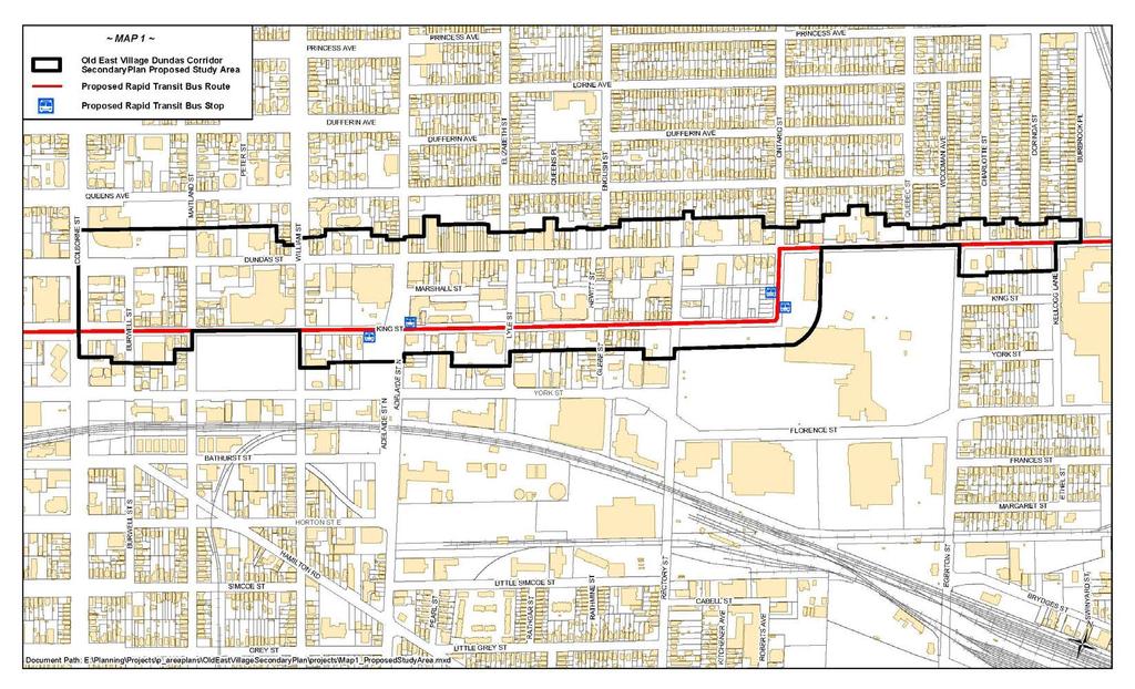
1 Report to Planning and Environment Committee To: From: Subject: Chair and Members Planning & Environment Committee John M. Fleming Managing Director, Planning and City Planner Old East Village Dundas Street Corridor Secondary Plan Draft Terms of Reference Public Participation Meeting on: April 30, 2018 Recommendation That, on the recommendation of the Managing Director, Planning and City Planner, the Terms of Reference for the Old East Village Dundas Street Corridor Secondary Plan, attached hereto as Appendix A, BE ENDORSED. Executive Summary The Old East Village Dundas Street Corridor Secondary Plan is intended to provide more specific policy direction, than the parent London Plan, for development and public projects within the secondary planning area. It responds to a number of emerging initiatives within the Old East Village Corridor including such things as the introduction of Bus Rapid Transit, an upcoming infrastructure and street renewal project, a cycling route assessment and various development pressures on the Corridor. The secondary plan is intended to be completed by the end of 2018, so that it can serve as the foundation for the design of the reconstruction of Dundas Street from Adelaide Street to Ontario Street. The Terms of Reference are the first step in the process of preparing the Secondary Plan and include the purpose, key issues to be addressed, study area, the proposed public engagement program and a timeline for completion. To meet the proposed timeline, Staff recommend that any changes to the terms of reference desired by Council be directed to Staff, so that they can make those changes and move forward with the secondary plan project immediately. Background 1.0 Purpose of the Secondary Plan The London Plan indicates that secondary plans may be used for a number of reasons: To provide more detailed guidance for the development of an identified area, in addition to the more general policies of the London Plan. To coordinate the development of an area that is subject to substantial change. Areas, in whole or in part, within the... Rapid Transit Corridor Place Type that may require vision and more specific policy guidance for transition from their existing form to the form envisioned by this Plan. The corridor along Dundas and King Streets, between Colborne Street and Burbrook Place/Kellogg Lane is such an area that would benefit from a secondary plan. This area has, or will be, experiencing a number of changes and exciting planning initiatives that will need to be carefully coordinated. They include: The London Plan assignment of the Rapid Transit Corridor Place Type along King Street and Dundas Street.
2
3 Planned construction of rapid transit along King Street from the Downtown through to Ontario Street, and proceeding along Dundas Street from Ontario Street through to Highbury Avenue and eventually to Fanshawe College. With this comes the important need to provide strong connections from the rapid transit stations at Adelaide and King Street and on Ontario Street, to the business corridor on Dundas Street. A planned higher order east-west cycle route through the Old East Village, to connect to the larger cycling network and Downtown. Reconstruction of the Dundas Street underground services and streetscape from Adelaide to Ontario Street with consideration of sewers, watermain, cycling, tree planting, on-street parking, enhanced streetscape amenities, furniture, etc. Planned construction of an Adelaide Street/CPR rail underpass, to the north of the Dundas Street corridor, and the important connections to it. Continued revitalization of the Western Fair market and fairgrounds, with the possibility of redevelopment of a portion of the fairground site. Redevelopment applications and multiple development interests for the lands along the Dundas Street corridor and King Street corridor some of which are seeking buildings of significant height. Heritage building conservation and consideration, which has served to establish a heritage image for the neighbourhood north of the corridor, attracting significant investment into the building stock. A desire for a green plan, and a recent patio design guideline, along the Dundas Street Corridor with the intent of setting the standard for a desirable pedestrian and patio experience. A secondary plan can knit all of these considerations together for the corridor, and set a more detailed policy context, development design guidelines, and a coordinated approach for delivering capital programs. 2.0 Timing Major Milestones It is intended that the Secondary Plan will be completed by the end of 2018, so that it can support the design and engagement process for the reconstruction of Dundas Street between Adelaide Street and Ontario Street. The following is a summary of how that process is proposed to occur: Step in Process Timing Terms of Reference Approved May, 2018 Background Research Undertaken May through June
4 Bicycle Network Evaluation May through September Public Workshop/Public Meetings June, 2018 Draft of Secondary Plan Public Meetings September, 2018 Final Secondary Plan December, 2018 Infrastructure Renewal and Streetscape Reconstruction 2019 Detailed Design Infrastructure Renewal and Streetscape Reconstruction 2020 Attached are the proposed Draft Terms of Reference. In advance of this meeting they have been circulated to the Old East Village Business Improvement Area (BIA) organization, Old East Village Community Association, and Staff leading the Shift Rapid Transit project. Notice was given of the Secondary Plan Terms of Reference on March 12, 2018 to other City departments and various agencies as well as within the Living in the City section of the London Free Press. Notice of Public Meeting was given in early April, Next Steps Following Council approval of the Terms of Reference, Planning staff will start the Secondary Plan process. The timeline to complete the secondary plan will be tight, with completion targeted for the end of It will be important to meet this date so that the secondary plan can serve as the foundation for the streetscape reconstruction project design in To achieve this, it will be important to complete the first secondary plan public engagement workshops in June of Conclusion The attached terms of reference will guide the preparation of the proposed Old East Village Dundas Corridor Secondary Plan. Given the importance of timeliness, Staff are recommending that Council move forward with these terms of reference. If amendments are desired by Council, it is recommended that Council identify these amendments now, so that staff can take that direction, make the necessary changes, and begin the secondary plan process immediately. Prepared by: Submitted by: W.J. Charles Parker, MA Senior Planner, Urban Regeneration Recommended by: Michael Tomazincic, MCIP, RPP Manager, Current Planning CP/JF John M. Fleming, MCIP, RPP Managing Director, Planning and City Planner
5 APPENDIX A OLD EAST VILLAGE DUNDAS STREET CORRIDOR SECONDARY PLAN TERMS OF REFERENCE Planning and Ongoing Initiatives in the Old East Village The corridor along Dundas and King Streets, between Colborne Street and Burbrook Place/Kellogg Lane has experienced, or will be experiencing, a number of changes and exciting planning initiatives that will need to be carefully coordinated. They include: The London Plan assignment of the Rapid Transit Corridor Place Type along King Street and Dundas Street. Planned construction of rapid transit along King Street from the Downtown through to Ontario Street, and proceeding along Dundas Street from Ontario Street through to Highbury Avenue. With this comes the important need to provide strong connections from the rapid transit stations at Adelaide and King Street and on Ontario Street, to the business corridor on Dundas Street. A planned higher order cycle route through the Old East Village, to connect to Downtown and the larger cycling network. Infrastructure renewal and streetscape improvements on Dundas Street from Adelaide to west of Ontario Street with consideration of watermain, sanitary and storm sewer replacements, new traffic signals, streetlights, cycling facilities, tree planting, on-street parking, enhanced streetscape amenities, furniture, etc. Planned construction of an Adelaide Street/CPR tracks underpass, to the north of the Dundas Street corridor, and the important connections to it. Continued revitalization of the Western Fair market and fairgrounds, with the possibility of redevelopment of a portion of the fairground site. Redevelopment applications and multiple development interests for the lands along the Dundas Street corridor and King Street corridor some of which are seeking buildings of significant height. Heritage building conservation and consideration, which has served to establish a heritage image for the neighbourhood north of the corridor, attracting significant investment into the building stock. A desire for a green plan, and a recent patio design guideline, along the Dundas Street Corridor with the intent of setting the standard for a desirable pedestrian and patio experience. Purpose of a Secondary Plan for the Old East Village Secondary plans are intended to: Allow for the development of policies for a specific area that may be more detailed than the general policies of the London Plan. Allow for more specific vision and policy guidance for lands with the Rapid Transit Corridor Place Type to assist with specific transition from their existing form to the form envisioned by the Plan. Assist in the implementation and refinement of the Plan. The proposed secondary plan will consider all of the existing and planned initiatives within the Old East Village (listed above) and, through a robust public engagement
6 program, allow for a more detailed vision and policy framework for planning development and public projects within the Dundas Corridor. The secondary plan may also include specific design guidance for development and public projects in the corridor. Defined Secondary Plan Area The secondary plan entitled, Our Move Forward: London s Downtown Plan extends to Colborne Street, defining the western boundary of the subject secondary plan. To the east, the McCormick Secondary Plan covers lands north of Dundas Street, east of Burbrook Place, defining the eastern boundary of the subject secondary plan. Accordingly, the secondary plan will consider lands that are included within the London Plan s Rapid Transit Corridor Place Type, between Colborne Street and Burbrook Place. Through the study process, this boundary may be adjusted where there it is determined that it would be advantageous to do so from a secondary planning perspective. The important context surrounding this defined area will be considered throughout the study process and in preparing the secondary plan Preliminary List of Issues to be Considered Through Secondary Plan Within the secondary plan area, there are a number of issues that will need to be considered. Below is a preliminary summary. There will likely be additional issues that surface through the secondary plan engagement process; they will also be addressed and incorporated into the ultimate secondary plan: King Street Rapid Transit Corridor Place Type - King Street has been identified in The London Plan as a Rapid Transit Corridor - This Place Type can support a broad range of uses - It also encourages intensification, supporting the assembly of properties to allow for redevelopment projects, where it is appropriate - Within this Place Type, The London Plan establishes maximum heights that can support high-rise forms of development where appropriate - The Rapid Transit Corridor Place Type also establishes a number of form policies that augment the City Design policies of the Plan - It may be desirable to establish more detailed and specific use, intensity or form policies for the King Street corridor, within the Study Area - The existing specific policies for the corridor that exist in the London Plan, which were originally established as a result of the Community Improvement Plan (policies that include an Area of Transition) will be re-evaluated, modified if necessary, and brought into the Secondary Plan as appropriate. Dundas Street Rapid Transit Corridor Place Type - Dundas Street has been identified in The London Plan as a Rapid Transit Corridor; accordingly, the background and issues identified above for King Street would apply for this corridor as well - However, for the Rapid Transit Corridor between Colborne Street and Quebec Street the London Plan identifies specific Main Street policies - These policies may allow for greater height and also may allow for more office floor area - It would be beneficial to identify, more specifically, where buildings of greater height will be directed along the corridor and where it is expected that mid-rise heights will be the maximum height that is permitted. - In general, it may be desirable to establish more detailed and specific use, intensity or form policies for the Dundas Street Rapid Transit corridor, within the Study Area Design Guidance - The London Plan provides City Design policies and some further form policies within the Rapid Transit Place Type - Furthermore, in April of 2016 the Old East Village Commercial Design manual was adopted by Council
7 - That said, it may be desirable to establish more specific design policies including non-commercial uses - that address specific considerations within the secondary plan area. - For example, it may be appropriate to identify design policies relating to the expected interface between taller buildings and the surrounding low density residential neighbourhoods adjacent to the corridor. - There may also be useful design guidance for public projects including streetscape improvements and the green plan concept that the Old East Village BIA has been discussing for many years. - It may be appropriate to incorporate all or a portion of the existing urban design guidelines into the secondary plan Cycling Network - The Cycling Master Plan identified a higher order connection between the Old East Village and Downtown, and more broadly between the Thames Valley Parkway and the Quebec Street / Egerton Street north-south route. With finalization of Rapid Transit routing in the downtown, this routing needs to be revisited. A cycling route assessment that considers origins, destinations, route characteristics and public input will provide guidance on the recommended route and cycling facility type. There are multiple options that require further consideration for example, Dundas Street, Queens Avenue, King Street. - Each of these options have significant implications for items such as on street parking, tree planting, street furniture, etc. Rapid Transit Connections - During the Bus Rapid Transit Environmental Assessment process, much discussion occurred in the Old East Village about the pro s and con s of routing rapid transit along Dundas Street (between Adelaide and Ontario) - While it was recognized that locating rapid transit on Dundas would leave no room for important main street amenities (trees, street furniture, patio space, etc.), there was an acute concern that transit traffic would be moving around the heart of the Old East Village and not directly through it. - In establishing the preferred route along King Street eastward to Ontario Street, key station connections to Dundas Street would be necessary. These include stations at King/Colborne, King/Adelaide and King/Ontario (mid-block). - The secondary plan will help to determine how a very positive/enticing pedestrian environment can be designed to create a strong connection between stations and the Dundas Street main street. Other Key Connections - Similar to consideration of connections to rapid transit, the secondary plan will provide an opportunity to consider connections from Dundas Street to other important locations such as the municipal parking lots located behind storefront buildings, Western Fair, the Market and Queens Park, etc. - Furthermore, connections to the recent Music, Entertainment and Culture Districts Strategy can be considered to evaluate whether there are measures that can be incorporated in the secondary plan to support the Old East Village s culture district status. Heritage Building Conservation - The lands within the secondary plan area are not included in the Old East Village Heritage Conservation District - However, these heritage resources represent a significant part of the image/brand of the Old East Village and their conservation is important - Heritage resources, their conservation, and how new development may be integrated into the corridor should be considered, in concert with the tools available under the Ontario Heritage Act Green Plan - The Old East Village BIA has long been interested in preparing a green plan that establishes a strategy for tree planting and other forms of landscaping within the corridor
8 - This can be a consideration when discussing design priorities and fundamental goals for the upcoming streetscape improvements Patios - The Old East Village Commercial Urban Design Manual approved by Council in April of 2016 included patio guidelines. - There may be policies stemming from this work, relating to patios, that should be included in the secondary plan - Alternatively, the guidelines could be incorporated into the secondary plan for greater patio design guidance On-street Parking - On-street parking is an important element for any main street s success. It provides main street customers with a convenient parking option and creates the optic of available parking, even when there are other municipal parking resources available nearby. - Furthermore, it tends to slow down car traffic and provide a comfortable buffer between pedestrians and automobile traffic. - One significant issue in the Old East Village is the very narrow road allowance from Adelaide Street to Ontario Street. How can on street parking fit into the road allowance together with enhanced tree planting, patios, street furniture and protected bicycle lanes. Some prioritization will be important Dundas Street Infrastructure Renewal and Streetscape Improvement Project - The infrastructure on Dundas Street between Adelaide Street and the future rapid transit route connection at Ontario Street requires renewal. This project will include watermain, sanitary and storm sewer replacements, new traffic signals, streetlights with consideration of tree planting, on-street parking, enhanced streetscape amenities and furniture. It is anticipated that all of the above can be useful to establish goals, objectives, priorities and conceptual directions for the upcoming Dundas Street streetscape improvement project - The planned re-design of York Street at Adelaide Street will be evaluated for its implications for example, Lyle Street and its intersection at Dundas Street - This project will draw from the public engagement, secondary plan policies and design guidelines to create a streetscape improvement plan that meets the needs and desires of the Old East Village neighbourhood, the Old East Village Business Improvement Area and those of the City of London community as a whole. Intended Outcomes The following are the outcomes that are intended from the secondary plan process: 1. Council adopted Old East Village Dundas Corridor Secondary Plan this secondary plan will have the force and effect of the Official Plan. The primary effect of the Plan will be to: a. Provide policy guidance/direction for private sector development within the corridor. b. Provide policy guidance/direction for public projects within the corridor. 2. A separately prepared plan for protected bicycle lanes through the Old East Village (integrated into the secondary plan 3. A completed public engagement process that informs Old East Village residents and business owners of the many initiatives currently underway or planned and results in a community-driven plan for the corridor, ultimately adopted by Council. 4. A strong foundation for the streetscape improvement design process 5. Re-evaluate the existing special policies that apply to the Dundas Street commercial corridor to determine if they can be enhanced and/or modified based on the success of new development proposals and incorporate these special policies into the secondary plan.

9 6. Complement the efforts of the Community Improvement Plan that has been adopted for the commercial corridor and has been instrumental in leading the rehabilitation of the area. Public Engagement Staff will work closely with the Old East Village BIA and the Old East Village Community Association to coordinate engagement activities. The intent is to use the engagement process to inform/educate, but primarily to develop a plan that reflects the aspirations of the business and residential community. The following are engagement techniques that will be used: 1. Community public meeting (2 in June, coordinated with community workshops) 2. Community workshops (2 in June) 3. Stakeholder meetings (May, June, July) 4. Community public meetings (2 in September response to Draft Secondary Plan) 5. Web page to provide information and seek information 6. On-street planning notification signage along Dundas Street, encouraging involvement in the process 7. Social media information 8. Attendance at BIA and Community Association meeting(s) 9. Public Participation Meeting at Planning Committee for adoption of the Plan Timeline Milestones The following shows the key milestones for the secondary plan process. It also shows how the completed secondary plan relates to the Dundas Infrastructure Renewal and Streetscape Improvement project.
1.0 Purpose of a Secondary Plan for the Masonville Transit Village
 Report to Planning and Environment Committee To: Chair and Members Planning & Environment Committee From: John M. Fleming Managing Director, Planning and City Planner Subject: Masonville Transit Village
The draft Secondary Plan will serve as the basis for further consultation with the community and stakeholders;
 File: O-8879 Planner: K. Killen Report to Planning and Environment Committee To: Chair and Members Planning & Environment Committee From: John M. Fleming Managing Director, Planning and City Planner Subject:
Old East Village Dundas Street Corridor Secondary Plan
 Old East Village Dundas Street Corridor Secondary Plan DRAF T February 2019 Contents 1.0 INTRODUCTION 1 1.1 Background 1 1.2 Location 2 1.3 Purpose and Use 3 1.4 Vision and Principles 4 2.0 CHARACTER
SUBJECT: GO Station Mobility Hubs Preferred Concepts: Aldershot GO, Burlington GO and Appleby GO. Planning and Development Committee - Public Meeting
 Page 1 of Report PB-76-17 SUBJECT: GO Station Mobility Hubs Preferred Concepts: Aldershot GO, Burlington GO and Appleby GO TO: FROM: Planning and Development Committee - Public Meeting Planning and Building
Welcome. Walk Around. Talk to Us. Write Down Your Comments
 Welcome This is an information meeting introducing the applications for proposed redevelopment of the Yorkdale Shopping Centre site at 3401 Dufferin Street and 1 Yorkdale Road over the next 20+ years,
38 Queen s University Campus Master Plan Part 1
 38 Queen s University Campus Master Plan Part 1 46 The Campus at the City Scale Chapter 4 The Campus at the City Scale 39 Queen s is an urban University centrally located in Kingston. Decisions made by
Report to: Development Services Committee Report Date: September 11, 2017
 ~RKHAM Report to: Development Services Committee Report Date: September 11, 2017 SUBJECT: PREPARED BY: Conceptual Master Plan for the Future Urban Area - Community Structure Plan and Key Policy Direction
CHAIR AND MEMBERS PLANNING & ENVIRONMENT COMMITTEE JOHN M. FLEMING MANAGING DIRECTOR, PLANNING AND CITY PLANNER
 TO: FROM: SUBJECT: CHAIR AND MEMBERS PLANNING & ENVIRONMENT COMMITTEE JOHN M. FLEMING MANAGING DIRECTOR, PLANNING AND CITY PLANNER APPLICATION BY: THE CORPORATION OF THE CITY OF LONDON OUTDOOR PATIOS IN
St. Lawrence Neighbourhood Focused Area - Official Plan Amendment Status Report
 STAFF REPORT ACTION REQUIRED St. Lawrence Neighbourhood Focused Area - Official Plan Amendment Status Report Date: May 21, 2015 To: From: Wards: Reference Number: Toronto and East York Community Council
Local Growth Planning in North Central Green Line Communities
 2018 April 30 Page 1 of 6 EXECUTIVE SUMMARY This report outlines a high-level scope for local growth planning for north central Green Line communities. The catalyst for this review is the significant investments
Official Plan Review: Draft Built Form Policies
 PG.30.1 REPORT FOR ACTION Official Plan Review: Draft Built Form Policies Date: May 15, 2018 To: Planning and Growth Management Committee From: Chief Planner and Executive Director, City Planning Division
Shift Rapid Transit Public Participation Meeting May 3, 2017
 Shift Rapid Transit Public Participation Meeting May 3, 2017 Shift Rapid Transit Initiative Largest infrastructure project in the city s history. Rapid Transit initiative will transform London s public
North Fair Oaks Community Plan Summary and Information
 North Fair Oaks Community Plan Summary and Information WHAT IS THE NORTH FAIR OAKS COMMUNITY PLAN? The North Fair Oaks Community Plan is part of the San Mateo County General Plan, and establishes policies
13 THORNHILL YONGE STREET STUDY IMPLEMENTATION CITY OF VAUGHAN OPA 669 AND TOWN OF MARKHAM OPA 154
 13 THORNHILL YONGE STREET STUDY IMPLEMENTATION CITY OF VAUGHAN OPA 669 AND TOWN OF MARKHAM OPA 154 The Planning and Economic Development Committee recommends the adoption of the recommendations contained
Downtown Streetscape Manual & Built Form Standards
 City of Guelph Downtown Streetscape Manual & Built Form Standards July 2014 Prepared by Brook McIlroy Inc. in association with Unterman McPhail Associates and McCormick Rankin Inc. City of Guelph Downtown
SUBJECT: Waterfront Hotel Planning Study Update TO: Planning and Development Committee FROM: Department of City Building. Recommendation: Purpose:
 Page 1 of Report PB-23-18 SUBJECT: Waterfront Hotel Planning Study Update TO: Planning and Development Committee FROM: Department of City Building Report Number: PB-23-18 Wards Affected: 2 File Numbers:
3. Endorse the LRT vision in transforming Surrey into Connected-Complete-Livable communities, and more specifically, the official vision statement:
 CORPORATE REPORT NO: R038 COUNCIL DATE: February 20, 2017 REGULAR COUNCIL TO: Mayor & Council DATE: February 16, 2017 FROM: General Manager, Engineering FILE: 8740-01 SUBJECT: Surrey Light Rail Transit
South of Eastern Strategic Direction Status Update
 STAFF REPORT ACTION REQUIRED South of Eastern Strategic Direction Status Update Date: July 10, 2014 To: From: Planning and Growth Management Committee Chief Planner and Executive Director, City Planning
SCARBOROUGH SUBWAY EXTENSION. Scarborough Subway Extension. Final Terms of Reference
 Scarborough Subway Extension Final Terms of Reference 1 1.0 Introduction and Background 1.1 Introduction Toronto City Council recently confirmed support for an extension of the Bloor-Danforth Subway from
The Project. In 2013, construction was completed between 100 Street and 102 Street.
 The Project Jasper Avenue New Vision (JANV) is a major catalyst project identified in the Capital City Downtown Plan (2010) between 92 Street and 109 Street, including the streets half a block north and
Transit-supportive development and city-building
 Photo: Michael Hiemstra (CC BY 2.0) Transit-supportive development and city-building Brief 3: Tools for building infrastructure and policy conditions Building the policy and infrastructure conditions Municipalities
NEW REGIONAL OFFICIAL PLAN HIGH LEVEL PROCESS & FRAMEWORK
 NEW REGIONAL OFFICIAL PLAN HIGH LEVEL PROCESS & FRAMEWORK Why A New Official Plan Originally the role of Regionally Planning and content of Regional Official Plan (1970s) primarily focused on protecting
CHAPTER 5: GUIDING PRINCIPLES
 CHAPTER 5: GUIDING PRINCIPLES The following 10 principles were developed based on public consultation, planning policy and the background analysis conducted during Phase 1. The Guiding Principles significantly
Queen Street West - Zoning Amendment Application - Preliminary Report
 STAFF REPORT ACTION REQUIRED 944-952 Queen Street West - Zoning Amendment Application - Preliminary Report Date: February 6, 2013 To: From: Wards: Reference Number: Toronto and East York Community Council
SUBJECT: Proposed Downtown Mobility Hub Precinct Plan and Proposed Official Plan Policies
 Page 1 of Report PB-81-17 SUBJECT: Proposed Downtown Mobility Hub Precinct Plan and Proposed Official Plan Policies TO: FROM: Committee of the Whole Planning and Building Department Report Number: PB-81-17
Director, Community Planning, Toronto and East York District
 Lower Yonge Precinct Plan Update STAFF REPORT ACTION REQUIRED Date: October 16, 2012 To: From: Wards: Reference Number: Toronto and East York Community Council Director, Community Planning, Toronto and
Don Mills Crossing Study and Celestica Lands Development Application Community Meeting, Open House, and Breakout Discussions
 Consultation Summary Don Mills Crossing Study and Celestica Lands Development Application Community Meeting, Open House, and Breakout Discussions This report is not intended to provide a verbatim transcript
CITY OF VAUGHAN EXTRACT FROM COUNCIL MEETING MINUTES OF JUNE 7, 2016
 Item 5, Report No. 26, of the Committee of the Whole (Working Session), which was adopted without amendment by the Council of the City of Vaughan on June 7, 2016. 5 MUNICIPAL CLASS ENVIRONMENTAL ASSESSMENT
Contact: Alex Taranu ( ) or Karl Walsh ( )
 or Karl Walsh ( )") Date: 09 September 2005 File: Subject: P03.DUDS Downtown Urban Design Vision Study Report Contact: Alex Taranu (905 874 3454) or Karl Walsh (905 874 2331) OVERVIEW Staff has produced an Urban Design Vision
Date: 09 September 2005 File: Subject: P03.DUDS Downtown Urban Design Vision Study Report Contact: Alex Taranu (905 874 3454) or Karl Walsh (905 874 2331) OVERVIEW Staff has produced an Urban Design Vision
Bloor St. W. Rezoning - Preliminary Report
 STAFF REPORT ACTION REQUIRED 1638-1644 Bloor St. W. Rezoning - Preliminary Report Date: April 1, 2008 To: From: Wards: Reference Number: Toronto and East York Community Council Acting Director, Community
Richmond Road Complete Street Meeting #1, April 25, 2016
 Richmond Road Complete Street Meeting #1, April 25, 2016 Agenda Overview Richmond Road Complete Street Other Ongoing Studies Discussion Map buses/day removed from Sir John A. Macdonald Parkway Confederation
Downtown Whitby Action Plan
 Downtown Whitby Action Plan Final Report October 2016 Table of Contents Introduction 1 Public Consultation 2 Walkability 3 Downtown Whitby Walkability Map 4 Vision 5 Goal & Objectives 6 Objective 1 7 Objective
Rapid Transit Implementation Working Group September 14, 2017
 Rapid Transit Implementation Working Group September 14, 2017 BACKGROUND Council approved the Rapid Transit Master Plan and Updated Business Case on July 25, 2017. Approval of the RTMP confirmed the BRT
PART 1. Background to the Study. Avenue Study. The Danforth
 The Danforth 1.1/ Study Purpose & Key Municipal Goals 1.2/ The Local Advisory Committee 1.3/ The Project Team 1.4/ Study Process/Summary of Method 1.5/ Summary of Consultation 1.1 Study Purpose and Key
Long Branch Neighbourhood Character Guidelines Final Report
 STAFF REPORT ACTION REQUIRED Long Branch Neighbourhood Character Guidelines Final Report Date: October 26, 2017 To: From: Wards: Reference Number: Etobicoke York Community Council Director, Community Planning,
ONTARIO MUNICIPAL BOARD
 PL 120483 ONTARIO MUNICIPAL BOARD Applicant/Appellant: 2124123 Ontario Limited Subject: OPA, Rezoning and Draft Plan of Subdivision Municipal Address: 3940 Highway 7 East Municipality: City of Markham
CITY CLERK. Parkland Acquisition Strategic Directions Report (All Wards)
") CITY CLERK Clause embodied in Report No. 10 of the, as adopted by the Council of the City of Toronto at its meeting held on November 6, 7 and 8, 2001. 10 Parkland Acquisition Strategic Directions Report
CITY CLERK Clause embodied in Report No. 10 of the, as adopted by the Council of the City of Toronto at its meeting held on November 6, 7 and 8, 2001. 10 Parkland Acquisition Strategic Directions Report
ARLINGTON COUNTY, VIRGINIA
 ARLINGTON COUNTY, VIRGINIA County Board Agenda Item Meeting October 15, 2005 DATE: September 28, 2005 SUBJECT: Request to Advertise the adoption of the 2005 Clarendon Sector Plan C. M. RECOMMENDATION:
Report to: Development Services Committee Report Date: April 24, 2017
 SUBJECT: Cornell Rouge National Urban Park Gateway - Report on Design Charrette and Next Steps PREPARED BY: Lilli Duoba, MES, MCIP, RPP, Manager, Natural Heritage (ext. 7925) REVIEWED BY: Marg Wouters,
QUEEN-RIVER SECONDARY PLAN
 34 QUEEN-RIVER SECONDARY PLAN 34. QUEEN RIVER SECONDARY PLAN 1. INTRODUCTION The Queen-River area is approximately 6.4 hectares and is located at the eastern edge of the Downtown as shown on Map 34-1.
CITY OF CAMBRIDGE Growth & Intensification Study Secondary Plan Stakeholder Session September 12th, 2016
 CITY OF CAMBRIDGE Growth & Intensification Study Secondary Plan Stakeholder Session September 12th, 2016 Dillon Consulting Limited Watson & Associates Economists Curtis Planning Inc. Tim Welch Consulting
Land Use Amendment in Southwood (Ward 11) at and Elbow Drive SW, LOC
 at and Elbow Drive SW, LOC") 2018 November 15 Page 1 of 10 EXECUTIVE SUMMARY This land use amendment application was submitted by Rick Balbi Architect on 2017 August 31 on behalf of Sable Developments Ltd, and with authorization from
2018 November 15 Page 1 of 10 EXECUTIVE SUMMARY This land use amendment application was submitted by Rick Balbi Architect on 2017 August 31 on behalf of Sable Developments Ltd, and with authorization from
Public Open House. Overview of the Downtown Plan Official Plan Amendment April 23, 2018
 Public Open House Overview of the Downtown Plan Official Plan Amendment April 23, 2018 1 A 25-Year Plan for Downtown To ensure growth contributes positively to Toronto s Downtown as a great place to live,
General Committee Presentation. Paddy Kennedy, MCIP, RPP Dillon Consulting Limited
 General Committee Presentation Paddy Kennedy, MCIP, RPP Dillon Consulting Limited November 2012 Location of Area 3 Fitch St. Prince Charles Dr. Area 3 First Ave Thorold Rd. Study Purpose At the time that
FOUR MILE RUN VALLEY WORKING GROUP AND CHARGE
 FOUR MILE RUN VALLEY WORKING GROUP AND CHARGE Adopted April 16, 2016 Amended July 19, 2016 Overview of Integrated Effort The overall goal of the Four Mile Run Valley (4MRV) initiative is to develop a comprehensive
Dundas Place Flexible Street Public Information Centre
 WELCOME TO THE DUNDAS PLACE DESIGN REVEAL Dundas Place Flexible Street Public Information Centre November 8, 2017 This project is funded by the City of London with support from the Government of Canada
THAT the attached Terms of Reference for the Thornhill Centre Street Study be approved.
 COMMITTEE OF THE WHOLE AUGUST 18, 2003 THORNHILL CENTRE STREET STUDY PLANNING FILE: 15.92 Recommendation The Commissioner of Planning recommends: THAT the attached Terms of Reference for the Thornhill
CITY OF VAUGHAN D R A F T YONGE STREET STUDY. June 2008 YOUNG + WRIGHT /IBI GROUP ARCHITECTS DILLON CONSULTING LTD.
 CITY OF VAUGHAN June 2008 YOUNG + WRIGHT /IBI GROUP ARCHITECTS GHK SUSTAINABILITY INTERNATIONAL + LIVABILITY (CANADA) LTD. = COMMUNITY VALUE DILLON CONSULTING LTD. Public Open House Tonight s Meeting WELCOME
SECTION E. Realizing the Plan
 SECTION E Realizing the Plan 60 DESIGN REGINA - OFFICIAL COMMUNITY PLAN SECTION E Realizing the Plan Design Regina has been an ambitious plan-making exercise, with a high level of community, stakeholder,
CITY OF CHARLOTTESVILLE, VIRGINIA CITY COUNCIL AGENDA
 CITY OF CHARLOTTESVILLE, VIRGINIA CITY COUNCIL AGENDA Agenda Date: December 16, 2013 Action Required: Adoption of Resolution Presenter: Staff Contacts: Title: James E. Tolbert, AICP, Director of NDS James
1071 King Street West Zoning Amendment Application - Preliminary Report
 STAFF REPORT ACTION REQUIRED 1071 King Street West Zoning Amendment Application - Preliminary Report Date: August 9, 2012 To: From: Wards: Reference Number: Toronto and East York Community Council Director,
Cambie Corridor Planning Program Phase Two Draft Plan. Standing Committee on City Services and Budgets May 5, 2011
 Cambie Corridor Planning Program Phase Two Draft Plan Standing Committee on City Services and Budgets May 5, 2011 Cambie Corridor Program Terms of Reference approved July 2009 Land Use Transportation Energy
Elfrida Growth Area Study
 Elfrida Growth Area Study Public Information Centre #2 December 6, 2017 6:00-8:30 pm PLANNING & ECONOMIC DEVELOPMENT DEPARTMENT Purpose of the Study The Elfrida Area has been identified as the preferred
Humber Bay Shores Precinct Plan Final Report
 STAFF REPORT ACTION REQUIRED Humber Bay Shores Precinct Plan Final Report Date: May 21, 2010 To: From: Wards: Reference Number: Etobicoke York Community Council Director, Community Planning, Etobicoke
Chairman and Members of the Planning and Development Committee. Thomas S. Mokrzycki, Commissioner of Planning and Building
 LA.09.TOR (Toronto) DATE: TO: FROM: SUBJECT: Chairman and Members of the Planning and Development Committee Thomas S. Mokrzycki, Commissioner of Planning and Building Central Waterfront Secondary Plan
CITY OF VAUGHAN EXTRACT FROM COUNCIL MEETING MINUTES OF NOVEMBER 15, 2016
 Item 11, Report No. 38, of the Committee of the Whole, which was adopted without amendment by the Council of the City of Vaughan on November 15, 2016. Regional Councillor Di Biase declared an interest
SPECIAL COMMITTEE OF THE WHOLE DECEMBER 9, 2002 BLOCK 57/58 WEST BLOCK PLAN BLOCK PLAN FILE BL.57/58W.99 HUNTINGTON BUSINESS PARK LAND OWNERS
 SPECIAL COMMITTEE OF THE WHOLE DECEMBER 9, 2002 BLOCK 57/58 WEST BLOCK PLAN BLOCK PLAN FILE BL.57/58W.99 HUNTINGTON BUSINESS PARK LAND OWNERS Recommendation The Commissioner of Planning recommends: THAT
TORONTO COMPLETE STREETS GUIDELINES
 TORONTO COMPLETE STREETS GUIDELINES Presentation by Fiona Chapman, Manager, Pedestrian Projects Public Realm Section, Transportation Services, City of Toronto June 2017 PURPOSE OF THE PROJECT To develop
9 CITY OF VAUGHAN OFFICIAL PLAN AMENDMENT NO BOCA EAST INVESTMENTS LIMITED
 9 CITY OF VAUGHAN OFFICIAL PLAN AMENDMENT NO. 631 - BOCA EAST INVESTMENTS LIMITED The Planning and Economic Development Committee recommends the adoption of the recommendations contained in the following
Status Update (2006 vs. Now) Citizen s Advisory Committee February Plan for Prosperity
 Citizen s Advisory Committee February Plan for Prosperity") Status Update (2006 vs. Now) Citizen s Advisory Committee February 2018 Plan for Prosperity 2000 2017 2000 2017 Gardnerville Population 6,000 5,760 5746 5,500 5,000 5,067 5,550 5,165 5,394 5,412 5,250
Status Update (2006 vs. Now) Citizen s Advisory Committee February 2018 Plan for Prosperity 2000 2017 2000 2017 Gardnerville Population 6,000 5,760 5746 5,500 5,000 5,067 5,550 5,165 5,394 5,412 5,250
Master Environmental Servicing Plan & Secondary Plan
 East Side Lands Stage 2 1 Master Environmental Servicing Plan & Secondary Plan Public Information Centre #1 June 16, 2016 Welcome! Today s Agenda Please sign in at the front desk. 5:30 pm 6:30 pm: Open
Plan Overview. Manhattan Area 2035 Reflections and Progress. Chapter 1: Introduction. Background
 Plan Overview The Manhattan Urban Area Comprehensive Plan (the Comprehensive Plan) is a joint planning initiative of the City of Manhattan, Pottawatomie County, and Riley County. The 2014 Comprehensive
URBAN DESIGN ACTION PLAN. Community Design and Environmental Services Committee April 20, 2009
 URBAN DESIGN ACTION PLAN Community Design and Environmental Services Committee April 20, 2009 What is the Urban Design Action Plan? The Action Plan is a guiding document to address how design-thinking
Rapid Transit Implementation Working Group
 Rapid Transit Implementation Working Group October 12, 2017 1 Agenda 1. Consultation Update 2. Technical Work Update 3. LTC Rapid Transit Integration 4. Next Steps 2 Consultation Update 3 Consultation
Chapter 2: Vision, Goals and Strategies
 Chapter 2: Vision, Goals and Lake Elmo Today & Tomorrow Comprehensive Plan 2040 2 VISION, GOALS & STRATEGIES - DRAFT 4-6-2018 INTRODUCTION Comprehensive Plan Purpose Perhapse the most important objective
Scope of Services. River Oaks Boulevard (SH 183) Corridor Master Plan
 Corridor Master Plan") Scope of Services River Oaks Boulevard (SH 183) Corridor Master Plan PROJECT AREA The project area consists of the River Oaks Boulevard (SH 183) corridor bounded by SH 199 at the northern end and the Trinity
Scope of Services River Oaks Boulevard (SH 183) Corridor Master Plan PROJECT AREA The project area consists of the River Oaks Boulevard (SH 183) corridor bounded by SH 199 at the northern end and the Trinity
WELCOME and introduction
 1 WELCOME and introduction Mobility Hub Locations within Burlington STUDY OVERVIEW STUDY OBJECTIVES The City of Burlington is developing four Area Specific Plans, one for each of Burlington s Mobility
Wellington Street West - Zoning Amendment Application - Preliminary Report
 STAFF REPORT ACTION REQUIRED 485-489 Wellington Street West - Zoning Amendment Application - Preliminary Report Date: September 26, 2016 To: From: Wards: Reference Number: Toronto and East York Community
ELMVALE ACRES SHOPPING CENTRE MASTER PLAN
 ELMVALE ACRES SHOPPING CENTRE MASTER PLAN Contents 1.0 INTRODUCTION... 2 2.0 LOCATION... 2 3.0 EXISTING CONTEXT... 2 4.0 VISION & GUIDING PRINCIPLES... 2 5.0 LAND USE AND BUILT FORM... 4 5.1 St. Laurent
Pearl Street and 15 Duncan Street - Zoning Amendment Application - Request for Direction Report
 STAFF REPORT ACTION REQUIRED 150-158 Pearl Street and 15 Duncan Street - Zoning Amendment Application - Request for Direction Report Date: April 16, 2018 To: From: Wards: Reference Number: Toronto and
141 GEORGE STREET PLANNING RATIONALE
 141 GEORGE STREET PLANNING RATIONALE MINOR ZONING BY-LAW AMENDMENT NOVEMBER 2, 2016 PLANNING RATIONALE 223 McLeod Street Ottawa, ON K2P 0Z8 613.730.5709 fotenn.com INTRODUCTION FOTENN Consultants is acting
Redevelopment of Ajax Plaza Area Public Open House Meeting February 19, 2015 Questions and Answers
 Redevelopment of Ajax Plaza Area Public Open House Meeting February 19, 2015 Questions and Answers Redevelopment of Ajax Plaza Area Why is the redevelopment of the Ajax Plaza important to the revitalization
Town of Oakville Streetscape Strategy
 Town of Oakville Streetscape Strategy Endorsed by PDC on February 10, 2014 (PD-011-14) Town of Oakville Streetscape Strategy [endorsed by PDC February 10, 2014] 0 Town of Oakville Streetscape Strategy
Urban Design Manual PLANNING AROUND RAPID TRANSIT STATIONS (PARTS) Introduction. Station Study Areas
 Introduction. Station Study Areas") 111111 PLANNING AROUND RAPID TRANSIT STATIONS (PARTS) Introduction The ION rapid transit system will link Waterloo, Kitchener and Cambridge through a central transit corridor (CTC). There are a number
111111 PLANNING AROUND RAPID TRANSIT STATIONS (PARTS) Introduction The ION rapid transit system will link Waterloo, Kitchener and Cambridge through a central transit corridor (CTC). There are a number
DRAFT Subject to Modifications
 TREASURE COAST REGIONAL PLANNING COUNCIL M E M O R A N D U M To: Council Members AGENDA ITEM 8 From: Date: Subject: Staff May 19, 2017 Council Meeting Florida Department of Transportation Complete Streets
Table of Contents. Elm Avenue Improvement Plan City of Waco, Texas. Introduction 1. Existing Context 1 Figure 1 2.
 Table of Contents Introduction 1 Existing Context 1 Figure 1 2 Plan Guidelines 3 Future Urban Form 4 The West-End 4 Main Street 6 The East-End 7 Figure 2 9 Public Improvement Recommendations 7 General
NO: R035 COUNCIL DATE: FEBRUARY 24, 2014
 CORPORATE REPORT NO: R035 COUNCIL DATE: FEBRUARY 24, 2014 REGULAR COUNCIL TO: Mayor & Council DATE: February 24, 2014 FROM: General Manager, Planning and Development FILE: 6520-01 SUBJECT: Town Centre
2 STATUTORY PUBLIC MEETING AND INFORMATION REPORT FOR PUBLIC MEETING ON AMENDMENT NO. 62 TO THE YORK REGION OFFICIAL PLAN
 2 STATUTORY PUBLIC MEETING AND INFORMATION REPORT FOR PUBLIC MEETING ON AMENDMENT NO. 62 TO THE YORK REGION OFFICIAL PLAN Pursuant to Section 17(15) of the Planning Act, as amended, the Regional Planning
5959 Yonge Street Rezoning Application - Preliminary Report
 STAFF REPORT ACTION REQUIRED 5959 Yonge Street Rezoning Application - Preliminary Report Date: February 23, 2011 To: From: Wards: Reference Number: North York Community Council Director, Community Planning,
UTSC SECONDARY PLAN COMMUNITY OPEN HOUSE
 WELCOME TO THE UTSC SECONDARY PLAN COMMUNITY OPEN HOUSE 1 Welcome to the first Community Open House for the UTSC Secondary Plan. Hosted by the University of Toronto Scarborough (UTSC), the following panels
YONGE STEELES CORRIDOR SECONDARY PLAN. Young + Wright / IBI Group Architects Dillon Consulting Ltd. GHK International (Canada) Ltd.
 Ltd.") PART A: PREAMBLE 1.0 PURPOSE The purpose of this Secondary Plan is to provide a development framework for intensification of the Yonge/ Steeles corridor including the north side of Steeles Avenue West
PART A: PREAMBLE 1.0 PURPOSE The purpose of this Secondary Plan is to provide a development framework for intensification of the Yonge/ Steeles corridor including the north side of Steeles Avenue West
Appendix E: Evaluation of Network Alternatives - July 2017
 Appendix E: Evaluation of Network Alternatives - July 2017 1 Overview This Appendix provides information used in the corridor level screening and detailed corridor assessment. Corridor Level Screening:
implementation r expression in landscape
 6 ubc okanagan implementation campus plan r expression in landscape 68 6 implementation campus plan sections The Campus Plan supports the academic mission, values and commitments of the University by providing
178 Carruthers Properties Inc.
 178 Carruthers Properties Inc. Planning Rationale for 178 Carruthers Avenue Site Plan Control Application June 2014 Table of Contents 1.0 Introduction 2.0 Overview of Subject Property 3.0 Current Zoning
B A C K GROUND PA P E R : D OW N TOW N R E V ITA LIZAT ION TOW N OF BRADFORD W EST GW ILLIMBURY OFFICIAL PLAN REVIEW
 B A C K GROUND PA P E R : D OW N TOW N R E V ITA LIZAT ION TOW N OF BRADFORD W EST GW ILLIMBURY OFFICIAL PLAN REVIEW For OPA Adoption December 2016 (This page is left intentionally blank) TOWN OF BRADFORD
Relief Line Project Assessment
 Relief Line Project Assessment Public Information Centre April 5, 2017 Tonight s Meeting PURPOSE To review the preferred alignment for the Local Segment. AGENDA 6:30 Open House 7:00 Presentation / Discussion
Animating the Rideau Canal December 2013
 Executive Summary Animating the Rideau Canal December 2013 Why study the Rideau Canal? The Rideau Canal has been an important part of Ottawa throughout its history, and has shaped and been shaped by the
12 AMENDMENT NO. 149, TOWN OF MARKHAM HIGHWAY 404 NORTH SECONDARY PLAN
 12 AMENDMENT NO. 149, TOWN OF MARKHAM HIGHWAY 404 NORTH SECONDARY PLAN The Planning and Economic Development Committee recommends the adoption of the recommendation contained in the following report August
The Corporation of the Town of Milton
 Report To: From: Council Barbara Koopmans, Commissioner, Planning and Development Date: May 7, 2018 Report No: Subject: Making it Possible Positioning the Town s Strategy for Growth and Economic Development
Waverley West B Secondary Planning Process. Open House South Pointe School April 25, 2018
 averley est B Secondary Planning Process South Pointe School April 25, 2018 averley est B Secondary planning process open house Please review the boards and provide your feedback. 1 The Role of a Secondary
PUBLIC OPEN HOUSE HURONTARIO-MAIN CORRIDOR SECONDARY PLAN
 PUBLIC OPEN HOUSE HURONTARIO-MAIN CORRIDOR SECONDARY PLAN Tuesday, February 28, 2012 6pm 9pm 1 st Floor Atrium, City Hall 2 Wellington Street West, Brampton 1 POLICY FRAMEWORK The 2006 Provincial Growth
S C O P E O F W O R K A P R I L
 white flint 2 sector plan S C O P E O F W O R K A P R I L 2 0 1 2 MONTGOMERY COUNTY PLANNING DEPARTMENT M-NCPPC MontgomeryPlanning.org 1 white flint 2 sector plan Scope of Work abstract This scope of work
COMMUNITY SUSTAINABILITY AND ENVIRONMENTAL MASTER PLAN IMPLEMENTATION UPDATE
 Attachment 1 COMMUNITY SUSTAINABILITY AND ENVIRONMENTAL MASTER PLAN IMPLEMENTATION UPDATE Priorities and Key Initiatives Committee May 2013 Page E-1 How we grow Goal 2: To ensure sustainable development
The Corporation of the TOWN OF MILTON
 Report to: From: Chair & Members of the Administration & Planning Standing Committee W.F. Mann, Director of Planning and Development Date: April 16, 2012 PD 022-12 (Z19/11) Subject: Technical Report Proposed
Toronto Complete Streets Guidelines Stakeholder Advisory Group #
 Toronto Complete Streets Guidelines Stakeholder Advisory Group #1 2015-03-24 What are Complete Streets? 2 Streets designed with all users in mind: pedestrians/those with disabilities cyclists street car
South Yonge Street Corridor
 South Yonge Street Corridor Streetscape Master Plan Study Draft Final Executive Summary Prepared by: January 2012 In Partnership with: Introduction The Future... Yonge Street is at the forefront of York
Town of Cobourg Heritage Master Plan. Statutory Public Meeting
 Town of Cobourg Heritage Master Plan Statutory Public Meeting April 25 th 2016 Presentation Overview 1. Introduction 2. Project background and schedule overview 3. Review of strategic direction content
~!VAUGHAN NOV Z November 21, Mr. Denis Kelly, Regional Clerk The Regional Municipality of York Yonge Street Newmarket, ON L3Y 6Z1
 ~!VAUGHAN NOV Z 5 2016 November 21, 2016 Mr. Denis Kelly, Regional Clerk The Regional Municipality of York 17250 Yonge Street Newmarket, ON L3Y 6Z1 Dear Mr. Kelly: RE: NEW KIRBY GO STATION IN BLOCK 27
Public Open House. Yonge Street and Bernard Avenue (Bernard KDA) Planning Study Update Town of Richmond Hill. March 30, 2017
 Planning Study Update Town of Richmond Hill. March 30, 2017") Public Open House Yonge Street and Bernard Avenue (Bernard KDA) Planning Study Update Town of Richmond Hill March 30, 2017 Open House Review of Project Purpose and Process Policy Refresher Highlights of
Public Open House Yonge Street and Bernard Avenue (Bernard KDA) Planning Study Update Town of Richmond Hill March 30, 2017 Open House Review of Project Purpose and Process Policy Refresher Highlights of
Implementation Guide Comprehensive Plan City of Allen
 Implementation Guide 2030 Comprehensive Plan City of Allen DRAFT 2015 Implementation Guide Allen 2030 Comprehensive Plan INTRODUCTION The Comprehensive Plan serves as a guide for the growth and development