San Joaquin River Restoration Program Mendota Pool Bypass and Reach 2B Improvements Project. Restoration Goal Technical Feedback Group
|
|
|
- Gwendolyn Rice
- 5 years ago
- Views:
Transcription
1 San Joaquin River Restoration Program Mendota Pool Bypass and Reach 2B Improvements Project Restoration Goal Technical Feedback Group March 20, :30 pm San Luis and Delta-Mendota Water Authority 842 Sixth St., Los Banos, CA
2 Agenda Restoration Goal Update Fishery Actions Update Reach 2B Project Status Update Reach 2B Project Alternatives Reach 2B Operations

3 Reach 2B Project Update
4 Reach 2B Project Update Available Technical Reports 1. Final Scoping Report February Exist. Env. Conditions: Data Needs and Survey Approach TM March Initial Options TM April Analytical Tools TM October Final Field Survey Report November Project Description TM October 2012 Public Draft EIS/R anticipated End of 2014
5 Reach 2B Project Update Project Process and Schedule Scoping Alternatives Formulation Final TM Oct Outreach/ Consensus Building EIS/R Public Draft EIS/R Late 2014 Final EIS/R Fall 2015 ROD/NOD ROD Winter 2015/2016 Detailed Design Land Acquisition Permitting Permits Fall 2016 Construction Procurement Land Acquisition begins 2016 Construction Construction begins 2017
6 Design Process Schedule Design Data Collection ongoing through 2014 Bypass and Structure Design 2014 and 2015 Reach 2B Levee Design Construction start date 2017

7 Purpose: Design Data Collection Update Inform Levee and Structure Design Soil Stratigraphy Soil Density Shear Stress

 Several Undisturbed")
8 Completed: Design Data Collection Update 40+ Standard Penetration Tests (SPTs) Several Undisturbed Drillholes


9 Completed: Design Data Collection Update 58 Cone Penetrometer Test (CPT) holes

10 Completed: Design Data Collection Update 3 monitoring wells Summer 2014: 40 SPTs 50+ CPTs Barge drilling Track drilling

11 Status Summary 2B Project moving forward with environmental compliance and design data collection concurrently Geotech investigations will lead to 10% design
12 Reach 2B Project Alternatives

13 Project Alternatives Vicinity Map
14 Project Alternatives Settlement Agreement Paragraph 11(a) (1) Creation of a bypass channel around Mendota Pool to ensure conveyance of at least 4,500 cfs from Reach 2B downstream to Reach 3. This improvement requires construction of a structure capable of directing flow down the bypass and allowing the Secretary to make deliveries of San Joaquin River water into Mendota Pool when necessary (2) Modifications in channel capacity (incorporating new floodplain and related riparian habitat) to ensure conveyance of at least 4,500 cfs in Reach 2B between the Chowchilla Bifurcation Structure and the new Mendota Pool bypass channel

15 Project Alternatives Overall Site Area
16 Major Components: Project Alternatives Major Project Components 1. Floodplain habitat 2 different floodplain widths 2. Bypass Restoration Flows around Mendota Pool 2 different routes 3. Deliver SJR water to Mendota Pool 4 different routes Combined variously to produce 4 alternatives for the EIS/R process Pieces can be combined differently for project implementation
17 Reach 2B Project Alternatives Four Alternatives presented in the Reach 2B Project Description TM Alternative A: Compact Bypass with Narrow Floodplain and South Canal Alternative B: Compact Bypass with Wide Floodplain and Bifurcation Structure Alternative C: Fresno Slough Dam with Narrow Floodplain and Short Canal Alternative D: Fresno Slough Dam with Wide Floodplain and North Canal
18 Alternative A Compact Bypass with Narrow Floodplain and South Canal Compact Bypass New channel and structures capable to convey up to 4,500 cfs of Restoration Flows around Mendota Pool Narrow Floodplain Floodplain habitat approx. 3,000 feet wide on average South Canal South Canal and structures to convey up to 2,500 cfs from Reach 2B to Mendota Pool (includes fish passage facility) Other Removal of Chowchilla riverside control structure

19 Alternative A Compact Bypass with Narrow Floodplain and South Canal

20 Alternative A Compact Bypass with Narrow Floodplain and South Canal
21 Alternative B Compact Bypass with Wide Floodplain and Bifurcation Structure Compact Bypass New channel and structures capable to convey up to 4,500 cfs of Restoration Flows around Mendota Pool Wide Floodplain Floodplain habitat approx. 4,200 feet wide on average Bifurcation Structure Mendota Pool control structure to convey up to 2,500 cfs from Reach 2B to Mendota Pool Other Fish passage facility at Compact bypass control structure Fish passage facility at Chowchilla riverside control structure

22 Alternative B Compact Bypass with Wide Floodplain and Bifurcation Structure

23 Alternative B Compact Bypass with Wide Floodplain and Bifurcation Structure
24 Alternative C Fresno Slough Dam with Narrow Floodplain and Short Canal Fresno Slough Dam New dam to restrict Mendota Pool to Fresno Slough so that up to 4,500 cfs of Restoration Flows can be conveyed around Mendota Pool Mendota Dam fish passage facility Narrow Floodplain Floodplain habitat approx. 3,000 feet wide on average Short Canal Short Canal and structures to convey up to 2,500 cfs from Reach 2B to Mendota Pool Other Fish passage facility at Chowchilla riverside control structure
25 Alternative C Fresno Slough Dam with Narrow Floodplain and Short Canal

26 Alternative C Fresno Slough Dam with Narrow Floodplain and Short Canal
27 Alternative D Fresno Slough Dam with Wide Floodplain and North Canal Fresno Slough Dam New dam to restrict Mendota Pool to Fresno Slough so that up to 4,500 cfs of Restoration Flows can be conveyed around Mendota Pool Mendota Dam fish passage facility Wide Floodplain Floodplain habitat approx. 4,200 feet wide on average North Canal North Canal and structures to convey up to 2,500 cfs from Reach 2B to Mendota Pool (with fish passage facility) Other Removal of Chowchilla riverside control structure

28 Alternative D Fresno Slough Dam with Wide Floodplain and North Canal

29 Alternative D Fresno Slough Dam with Wide Floodplain and North Canal
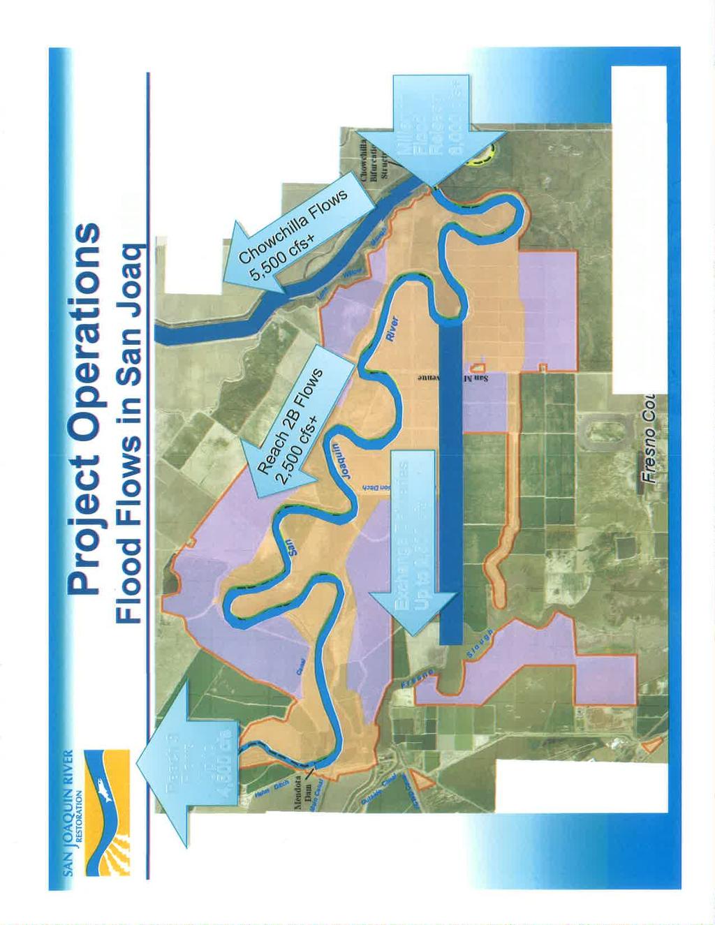
30 Reach 2B Project Operations
31 Project Operations Primary operations are flow routing Types of flows in Reach 2B: Restoration Flows Deliveries to Mendota Pool from the San Joaquin River Millerton Lake flood releases (via San Joaquin River) Pine Flat Reservoir flood releases (via Fresno Slough) Local diversions to and from Mendota Pool
32 Project Operations Flood Flow Scenarios Three basic flood flow scenarios: 1. No Flood Releases (critical-low to normal-wet water years) Restoration Flows will proceed through Reach 2B Irrigation deliveries and diversions will occur in Mendota Pool No interaction between the Restoration Flows in Reach 2B and Mendota Pool (outside of Exchange Contract delivery)


33 Project Operations No Flood Releases Alternative A Reach 3 Flows Up to 4,500 cfs Restoration Flows Up to 4,500 cfs Exchange Deliveries via South Canal Up to 2,500 cfs
34 Project Operations No Flood Releases Alternative B Reach 3 Flows Up to 4,500 cfs Exchange Deliveries via Bifurcation Structure Up to 2,500 cfs Restoration Flows Up to 4,500 cfs


35 Project Operations No Flood Releases Alternative C Reach 3 Flows Up to 4,500 cfs Close Mendota Gates & Reform Pool Exchange Deliveries via Short Canal Up to 2,500 cfs Restoration Flows Up to 4,500 cfs

36 Project Operations No Flood Releases Alternative D Reach 3 Flows Up to 4,500 cfs Exchange Deliveries via North Canal Up to 2,500 cfs Restoration Flows Up to 4,500 cfs
37 Project Operations Flood Flow Scenarios Three basic flood flow scenarios, cont.: 2. Flood Flows in San Joaquin (normal-wet to wet water years) Flood releases from Millerton Lake Flood flows possibly diverted from Reach 2B into the Chowchilla Bypass and/or Mendota Pool Some portion of flood flows is anticipated to perform as Restoration Flows in Reach 2B Flood management agencies will have ultimate discretion in directing flood flows

38
39 Project Operations Flood Flow Scenarios Three basic flood flow scenarios, cont.: 3. Flood flows in San Joaquin & Kings River (wet water years) Flood releases from Pine Flat Reservoir via Fresno Slough San Joaquin flood flows diverted from Reach 2B into the Chowchilla Bypass Some portion of the San Joaquin River flows is anticipated to perform as Restoration Flows in Reach 2B Flood management agencies will have ultimate discretion in directing flood flows

40
41 Questions?
42 Ali Forsythe SJRRP Program Manager
Update on the Bayfront Canal Bypass Project. Recommendation This an informational item only. No City Council action is required at this time.
 AGENDA ITEM H-7 continued from 4/18 Public Works STAFF REPORT City Council Meeting Date: 4/18/2017 Staff Report Number: 17-081-CC Informational Item: Update on the Bayfront Canal Bypass Project Recommendation
FISH RESTORATION PROGRAM AGREEMENT Implementing Habitat Restoration Requirements Of The Biological Opinions
 FISH RESTORATION PROGRAM AGREEMENT Implementing Habitat Restoration Requirements Of The Biological Opinions Dennis McEwan Department of Water Resources waterways tidal wetlands Whipple et al. 2012: Sacramento-San
North Branch of Cypress Creek Ecological Restoration: A Comprehensive Approach to Stream Restoration
 North Branch of Cypress Creek Ecological Restoration: A Comprehensive Approach to Stream Restoration Rocky Powell Clear Creeks Consulting, LLC Keith D. Tate, P.E. BayLand Consultants & Designers, Inc.
Once Upon a Gravel Pit: Reconnecting Floodplain through Aggregate Extraction
 Once Upon a Gravel Pit: Reconnecting Floodplain through Aggregate Extraction 5 th International Conference on Natural Channel Systems September 26, 2016 1 The Story of Snyder s Flats Historical influences
MPDP VEGETATION ADVISORY WORKGROUP WORKSHOP #1
 DATE: TO: LOCATION: MPDP Vegetation Advisory Workgroup SWA Group Office, 1245 West 18 th Street Meeting Purpose: Workgroup Orientation Introduce Participants to the Project Goals Develop a Statement of
Pine Flat Lake Master Plan Update FACT SHEET September 2014
 Pine Flat Lake Master Plan Update FACT SHEET September 2014 PURPOSE AND OBJECTIVE The U.S. Army Corps of Engineers Sacramento District is revising the 1976 Pine Flat Lake Master Plan and is seeking public
HISTORICAL ECOLOGY OF THE DELTA Emerging Concepts about a Spatially Complex and Temporally Dynamic System
 ITEM REMOVED DUE TO COPYRIGHT STATUS HISTORICAL ECOLOGY OF THE DELTA Emerging Concepts about a Spatially Complex and Temporally Dynamic System Robin Grossinger and Alison Whipple San Francisco Estuary
Regional Restoration Planning:
 Regional Restoration Planning: A Case Study in Collaborative Restoration Science and Planning Campbell Ingram, Executive Officer NCER August 28, 2018 Co-Equal Responsibilities Act as a primary state agency
The Napa River Flood Protection Project
 The Napa River Flood Protection Project Creating Flood Protection and Restoring Geomorphic and Biological Processes Jeremy Sarrow, Napa County Flood Control & Water Conservation District June 2, 2014.
Kootenai River Habitat Restoration Program June 18, 2018 Kootenai Valley Resource Initiative Update
 Kootenai River Habitat Restoration Program June 18, 2018 Kootenai Valley Resource Initiative Update Kootenai River Habitat Restoration Program Multi-year habitat restoration program Restoration treatments
Construction Progress Report
 Report Date: 4/8/2017 Subject: Construction Week 2 70% Complete Project: Sunset Pond EWP Stream Reclamation, Fourmile Creek, Boulder County, CO Report By: TJ Burr, Civil Engineer/Stream Restoration Specialist,
Peoria Riverfront Development (Ecosystem Restoration) Upper Mid-sized Island Critical Restoration Project (September 2011)
 Upper Mid-sized Island Critical Restoration Project (September 2011)") Peoria Riverfront Development (Ecosystem Restoration) Upper Mid-sized Island Critical Restoration Project (September 2011) Description The Corps of Engineers, Rock Island District (District) and the Illinois
Peoria Riverfront Development (Ecosystem Restoration) Upper Mid-sized Island Critical Restoration Project (September 2011) Description The Corps of Engineers, Rock Island District (District) and the Illinois
C. WATER. 1. Surface Water Runoff. See Section C.3, Flood Hazard/Mudflow Hazard, page Ground Water
 C. WATER 1. Surface Water Runoff See Section C.3, Flood Hazard/Mudflow Hazard, page 67. 2. Ground Water Determined not significant by the October 1984 and January 1999 Initial Studies conducted by the
Fisher Slough Tidal Marsh Restoration Project Scaling Down the Restoration Planning & Analysis Framework to Evaluate Project Alternatives
 Fisher Slough Tidal Marsh Restoration Project Scaling Down the Restoration Planning & Analysis Framework to Evaluate Project Alternatives Project Sponsor/Partners The Nature Conservancy Dike District #3
Working with Partners to Manage Recreation Sites. Dave Samson California Department of Water Resources
 Working with Partners to Manage Recreation Sites Dave Samson California Department of Water Resources FERC Recreation Workshop, Ontario, CA February 17-19, 2015 CALIFORNIA STATE WATER PROJECT OROVILLE
APPENDIX C NATURAL RESOURCES MANAGEMENT PLAN: ACTIONS AND PRIORITIES
 APPENDIX C NATURAL RESOURCES MANAGEMENT PLAN: ACTIONS AND PRIORITIES TABLE C-1: Resource Actions and Priorities GOAL NRM-4 Objective 4.1: Restore Natural floodplain functions. Objective 4.2: Define and
One River Environmental Assessment. Welcome!
 One River Environmental Assessment Welcome! One River Environmental Assessment Welcome to the One River Environmental Assessment Public Information Centre. Please explore each presentation area to learn
Public Meeting for the Redevelopment of. July 17,2018 7pm to 9pm Rolling Knolls Elementary School
 Public Meeting for the Redevelopment of July 17,2018 7pm to 9pm Rolling Knolls Elementary School Meeting Agenda Welcome/ Community Meeting Key Project Information History - Damian Cosby, DRP- Chief of
EMERGENCY ACTION PLAN
 EMERGENCY ACTION PLAN Lake Sunapee Dam Sunapee, NH Dam #229.04 (Class B Dam) Water Division Lake Sunapee Dam - Sunapee, NH TABLE OF CONTENTS Section 1 Section 2 Section 3 Section 4 Notification Flowchart
Corridor Management Committee. September 29, 2017
 Corridor Management Committee September 29, 2017 1 Today s Topics Chair s Update Proposed Corridor Protection Wall Aesthetic Design Overview Public Outreach Environmental Review Civil Construction Update
CHAPTER 2 SUMMARY 1. PROJECT SUMMARY DATA
 CHAPTER 2 SUMMARY This is an Initial Study format used to determine, pursuant to CEQA Guidelines Section 15177, whether a project 1) is within the scope of a Master EIR (MEIR), 2) may result in additional
TOWN OF BETHLEHEM OPEN SPACE CONSERVATION PLAN PUBLIC MEETING: OCTOBER 12, 2017
 TOWN OF BETHLEHEM OPEN SPACE CONSERVATION PLAN PUBLIC MEETING: OCTOBER 12, 2017 Welcome and Agenda 6:00 6:45: Open House, Part One 6:45 7:15: Presentation and Questions 7:15 8:00: Open House, Part Two
South Bismarck Watershed Model Update and Stormwater Improvement Project
 Preliminary Engineering Report Bismarck Tribune South Bismarck Watershed Model Update and Stormwater Improvement Project City of Bismarck, ND January 2017 14.105.0046 1.0 Executive Summary The focus of
STAFFORD TRACT NORTH OF US90A 1.0 INTRODUCTION 1.1 OBJECTIVE
 1.0 INTRODUCTION 1.1 OBJECTIVE This report, prepared for submittal to TxDOT, analyzes existing and proposed detention facilities draining into the TxDOT US90A storm sewer system. The results of the detailed
Town of Lyons Parks Flood Recovery Planning Process. Photograph courtesy of Ed Bruder
 Town of Lyons Parks Flood Recovery Planning Process Photograph courtesy of Ed Bruder Lyons Parks and Recreation Flood Recovery Update 1. Meadow Park Phase II - Project PW20B1 Estimated Completion: Summer
Rainwater Harvesting: Where does the Rainfall Go?
 Rainwater Harvesting: Where does the Rainfall Go? Justin Mechell Extension Assistant Department of Biological and Agricultural Engineering Texas A&M University Objectives Understand a watershed and how
STREAM BANK STABILIZATION THORPS MORTIMER RECREATION AREA Grandfather Ranger District SITE LOCATION & DRAINAGE AREA
 STREAM BANK STABILIZATION THORPS CREEK @ MORTIMER RECREATION AREA SITE LOCATION & DRAINAGE AREA SITE LOCATION Drainage Area = 1.14 sq. miles STREAM BANK STABILIZATION THORPS CREEK @ MORTIMER RECREATION
NOTICE OF PREPARATION
 NOTICE OF PREPARATION To: All Interested Parties Subject: Notice of Preparation of an Environmental Impact Report From: City of Petaluma Address: 11 English Street, Petaluma, CA 94952-2610 Contact: Heather
Public Information Meeting on Aquatic Plant Management: Lakes Mendota, Monona, Wingra, Waubesa, and Kegonsa. October 2 and 9, :00-8:30 p.m.
 Public Information Meeting on Aquatic Plant Management: Lakes Mendota, Monona, Wingra, Waubesa, and Kegonsa October 2 and 9, 2017 7:00-8:30 p.m. Agenda Welcome and introductions Overview of aquatic plant
GREATER DES MOINES WATER TRAILS AND GREENWAYS PLAN
 GREATER DES MOINES WATER TRAILS AND GREENWAYS PLAN A shared vision for our rivers, creeks and greenways. www. Des Moines Area MPO Iowa Department of Natural Resources Iowa s First Regional Water Trails
April 11, 2016 Park Board Chair and Commissioners General Manager Vancouver Board of Parks and Recreation New Brighton Salt Marsh - Preferred Concept
 TO: FROM: SUBJECT: April 11, 2016 Park Board Chair and Commissioners General Manager Vancouver Board of Parks and Recreation New Brighton Salt Marsh - Preferred Concept RECOMMENDATION A. THAT the Vancouver
VILLAGE OF BOLTON HERITAGE CONSERVATION DISTRICT PLAN
 Page 1 1. INTRODUCTION AND BACKGROUND 1.1 THE PROJECT VILLAGE OF BOLTON HERITAGE CONSERVATION DISTRICT PLAN TERMS OF REFERENCE The Town of Caledon (Town) is a large, predominantly rural municipality with
The Trinity River Corridor Project Update
 The Trinity River Corridor Project Update Councilmember Carolyn A. Davis Community Meeting October 14, 2008 The project covers 20 miles of the Trinity River, approx. 10,000 acres 2 Trinity River Corridor
Draft Rhode Island Stormwater Design and Installation Standards Manual
 Draft Rhode Island Stormwater Design and Installation Standards Manual Summary The May 2009 Public Review Draft version of the RI Stormwater Design and Installation Standards Manual consists of approximately
Regional Context Statement
 Regional Context Statement REGIONAL CONTEXT STATEMENT 3. REGIONAL CONTEXT STATEMENT In 1995, the Provincial Government passed into law the Growth Strategies Act. The purpose of this provincial initiative
WET PONDS INSPECTION & MAINTENANCE CHECKLIST
 WET PONDS INSPECTION & MAINTENANCE CHECKLIST INTRODUCTION Once construction is completed, periodic site inspections are essential in order to monitor the effectiveness and to anticipate the maintenance
Improving Communities Through the Arroyo Seco Sustainability Campaign and Watershed Assessment
 Improving Communities Through the Arroyo Seco Sustainability Campaign and Watershed Assessment Arroyo Seco Headwaters in the San Gabriel Mountains Major tributary to the Los Angeles River 44 square mile
Lower Meramec Multi-Jurisdictional Floodplain Management Plan Public Involvement (Results of Early Public Engagement) 27 June 2018
 27 June 2018") Lower Meramec Multi-Jurisdictional Floodplain Management Plan Public Involvement (Results of Early Public Engagement) 27 June 2018 Public Involvement Summary: The planning process includes opportunities
Lower Meramec Multi-Jurisdictional Floodplain Management Plan Public Involvement (Results of Early Public Engagement) 27 June 2018 Public Involvement Summary: The planning process includes opportunities
BRADENTON RIVERWALK EXPANSION MASTER PLAN
 BRADENTON RIVERWALK EXPANSION MASTER PLAN INTRODUCTION & AGENDA Process Update Community Engagement Summary Center for Active Design (CfAD) Recommendations Context and Existing Conditions Master Plan Alternatives
Table of Contents G.1.a Water Resources - Surface Water - Drainage
 Table of Contents G.1.a Water Resources - Surface Water - Drainage 1. INTRODUCTION... 1335 2. ENVIRONMENTAL SETTING... 1335 a. Regional Hydrology... 1335 b. Local Hydrology... 1337 c. On-site Hydrology...
From: Sent: To: Cc: Harmon, Dan; Erik Dickson RE: South Avenue Bridge Project, Missoula County // Request for comment
 From: Sent: To: Cc: Subject: Knotek, William Friday, October 21, 201610:25 AM Schick, Jon; Schock, Larry; Storer, Robert; Kenning, Jon; Ferree, Jonathan; 'tklietz@co.missoula.mt.us';'mike_mcgrath@fws.gov';
HIGH-SPEED RAIL PROGRAM UPDATE. Gilroy Unified School District & Gilroy City Council September 24, 2018 Gilroy City Council Chambers, Gilroy, CA
 HIGH-SPEED RAIL PROGRAM UPDATE Gilroy Unified School District & Gilroy City Council September 24, 2018 Gilroy City Council Chambers, Gilroy, CA OVERVIEW Introductions High-Speed Rail Project Update Overview
Public Review Draft Oceanside Subarea Habitat Conservation Plan/ Natural Communities Conservation Plan
 Oceanside Subarea Habitat Conservation Plan/ Natural Communities Conservation Plan Prepared for City of Oceanside Planning Department 300 N. Coast Highway Oceanside, CA 92054 Prepared by Ogden Environmental
WASHINGTON COUNTY OREGON
 WASHINGTON COUNTY OREGON LONG RANGE PLANNING DIVISION North Bethany Subarea Stream Corridors: Existing Regulations In Oregon, there is a distinct difference between the land use rules that apply in rural
Arkansas River Corridor
 Planning for Access Welcome to the Access Project. This project is a recreational planning effort in response to an interest by regional communities along the Arkansas River corridor. The project plan
SECTION 4(f) DE MINIMIS DOCUMENTATION
 DE MINIMIS DOCUMENTATION") SECTION 4(f) DE MINIMIS DOCUMENTATION Illinois Route 60/83 IL 176 to the intersection of IL 60 (Townline Road) Lake County P-91-084-07 Mundelein Park and Recreation District Project Limit SECTION 4(f)
SECTION 4(f) DE MINIMIS DOCUMENTATION Illinois Route 60/83 IL 176 to the intersection of IL 60 (Townline Road) Lake County P-91-084-07 Mundelein Park and Recreation District Project Limit SECTION 4(f)
I. INTRODUCTION. identify long-term capital improvements and rehabilitation measures for the existing drainage system;
 I. INTRODUCTION The Town of Windsor, Colorado is presently experiencing rapid growth and development within the boundaries of several of its major drainage basins. As growth continues within these basins,
City Council Special Meeting AGENDA ITEM NO. C.
 City Council Special Meeting AGENDA ITEM NO. C. DATE: 01/04/2019 TO: Honorable Mayor and City Council Members SUBJECT: Transit Villages Specific Plan project Study Session (Development Services Director
Table of Contents TABLE OF CONTENTS SECTION TITLE PAGE
 TABLE OF CONTENTS SECTION TITLE PAGE 1 INTRODUCTION AND OVERVIEW 1-1 1.1 Purpose and Need 1-1 1.2 Goals and Objectives 1-3 1.3 Overview of the Planning Process 1-5 1.4 Federal and State Requirements and
Ashbridges Bay Erosion and Sediment Control Project
 Ashbridges Bay Erosion and Sediment Control Project Project Brief Overview Toronto and Region Conservation Authority, in partnership with the City of Toronto, intends to carry out remedial erosion control
Is a Riparian Restoration Still Viable After 100-year Storm Events Alter the Original Design?
 Is a Riparian Restoration Still Viable After 100-year Storm Events Alter the Original Design? Sarah Spear Cooke, Ph.D. Seattle, Washington Presentation Outline Introduction The site pre-restoration Restoration
Bassett Creek Valley Working Group. October 4, 2017
 Bassett Creek Valley Working Group October 4, 2017 1 Today s Topics Introductions Overview of Design Teams (P+W and WSP) Expertise Working Group Roles and Responsibilities Schedule & Community Engagement
RIVER RECREATION AND CONSERVATION: LESSONS FROM COLORADO S 2013 FLOODS
 RIVER RECREATION AND CONSERVATION: LESSONS FROM COLORADO S 2013 FLOODS SORP RMIS May 2016 L O G A N S I M P S O N Agenda Why Are You Here? Land Use Resiliency Public Outreach Dialogue Recreation and Land
Summary of Changes in the DRAFT Rivers Project Natural Resource Master Plan from the 2001 approved plan to 2014 plan
 Summary of Changes in the DRAFT Rivers Project Natural Resource Master Plan from the 2001 approved plan to 2014 plan The entire Master Plan format and layout has been changed to comply with regulation
SOUTHERN GRAMPIANS WETLANDS INFORMATION DAY Sunday 23 rd November 2014
 SOUTHERN GRAMPIANS WETLANDS INFORMATION DAY Sunday 23 rd November 2014 Progress of wetland restoration trials at Walker, Gooseneck and Brady Swamps Mark Bachmann, Nature Glenelg Trust (NGT) The Walker,
Humber Bay Shores Precinct Plan Final Report
 STAFF REPORT ACTION REQUIRED Humber Bay Shores Precinct Plan Final Report Date: May 21, 2010 To: From: Wards: Reference Number: Etobicoke York Community Council Director, Community Planning, Etobicoke
Vaughan Metropolitan Centre (VMC) Black Creek Renewal CLASS ENVIRONMENTAL ASSESSMENT
 Black Creek Renewal CLASS ENVIRONMENTAL ASSESSMENT") PUBLIC INFORMATION CENTRE Vaughan Metropolitan Centre (VMC) Black Creek Renewal Wednesday, May 10, 2017 6:00 p.m. to 8:00 p.m. Add photo Project Management, Environmental Assessment, Stormwater Management
PUBLIC INFORMATION CENTRE Vaughan Metropolitan Centre (VMC) Black Creek Renewal Wednesday, May 10, 2017 6:00 p.m. to 8:00 p.m. Add photo Project Management, Environmental Assessment, Stormwater Management
Remi Mendoza City Planning Academy March 13, 2017
 Remi Mendoza City Planning Academy March 13, 2017 1 What is the General Plan? The 2030 General Plan 5-Year Update (2035 General Plan) Questions and Answers 2 Guidebook for development and growth Required
COLLIER BOULEVARD (CR 951) CORRIDOR
 CORRIDOR") Project(s) Goals Improve Traffic Circulation, Capacity & Safety Focus on Safety During Design & Construction Address Public Concerns Design an Aesthetically Pleasing Project Limit Environmental Impacts
Project(s) Goals Improve Traffic Circulation, Capacity & Safety Focus on Safety During Design & Construction Address Public Concerns Design an Aesthetically Pleasing Project Limit Environmental Impacts
4/8/2015 Item #10D Page 1
 MEETING DATE: April 8, 2015 PREPARED BY: Christy Villa, Associate Civil Engineer DEPT. DIRECTOR: Glenn Pruim DEPARTMENT: Public Works CITY MANAGER: Larry Watt SUBJECT: NORTH COAST HIGHWAY 101 STREETSCAPE
WORK SESSION ITEM City Council
 DATE: STAFF: January 28, 2014 Ken Sampley, Stormwater/Floodplain Program Mgr Jon Haukaas, Water Engr Field Operations Mgr WORK SESSION ITEM City Council SUBJECT FOR DISCUSSION Boxelder Basin Regional Stormwater
Joe Pool Lake Lake Master Plan Public Information Meeting Presentation of Final Draft Revision July 31, 2018
 Joe Pool Lake Lake Master Plan Public Information Meeting Presentation of Final Draft Revision July 31, 2018 Presented By Jeremy Spencer Lake Manager U.S. Army Corps of Engineers Fort Worth District US
Habitat Connectivity and Wildlife Corridor Stakeholder Meeting
 Habitat Connectivity and Wildlife Corridor Stakeholder Meeting VENTURA COUNTY PLANNING DIVISION JUNE 8, 2017 Agenda Introductions, Meeting Goal, and Format January 2017 Board Action Current Project Phasing
Planning Proposal Charlestown Swim and Leisure Centre LEP Amendment
 Planning Proposal Charlestown Swim and Leisure Centre LEP Amendment Amendment No. 4 to Lake Macquarie Local Environmental Plan 2014 (PP_2014_LAKEM_005_00) Local Government Area: Name of Draft LEP: Lake
City of Missoula and Missoula County Open Space Planning Open House
 City of Missoula and Missoula County Open Space Planning Open House FEBRUARY 6, 2018 The following slides contain the display board content from the open house. Please use boards to answer questions in
When planning stormwater management facilities, the following principles shall be applied where possible.
 2.0 Principles When planning stormwater management facilities, the following principles shall be applied where possible. 2.0.1 Drainage is a regional phenomenon that does not respect the boundaries between
Ecological Restoration at the Las Vegas Springs Preserve. Von K. Winkel, Ph.D.
 Ecological Restoration at the Las Vegas Springs Preserve Von K. Winkel, Ph.D. The Las Vegas Springs Before Disturbance The springs are very large. A small creek flows from each of 3 or 4 springs and
SECTION 5: REACH RECOMMENDATIONS/MAPS
 SECTION 5: REACH RECOMMENDATIONS/MAPS This section describes areas of concern and provides specific recommendations for each project reach. Locations of stormwater drains were from GIS coverage supplied
CITY COUNCIL AGENDA REPORT
 CITY COUNCIL AGENDA REPORT Subject: DESIGNATED FLOOD LINE CARROT CREEK Recommendation(s) That Administration bring forward a Land Use Bylaw amendment in October 2014 establishing the Designated Flood Line
Tentatively Selected Plan within Harlem River, East River and Western Long Island Sound Planning Region. First Level Costs. Federal Non-Federal Total
 HARLEM RIVER, EAST RIVER AND WESTERN LONG ISLAND SOUND PLANNING REGION Flushing Bay and Creek Ecosystem Restoration Source Feasibility Study Background Study Resolution (1994), Reconnaissance Report (1996),
Grantham Southern Quadrant Link Road Environmental Statement
 Grantham Southern Quadrant Link Road Environmental Statement Non Technical Summary Introduction Lincolnshire County Council (LCC) is submitting a planning application for the proposed implementation of
Rt. 29 Solutions Project Delivery Advisory Panel. January 7, 2016
 Rt. 29 Solutions Project Delivery Advisory Panel January 7, 2016 Agenda item 1: Introductions Project Delivery Advisory Panel Technical Team 2 Agenda item 2: Interaction and Feedback Live Streaming Dec
Coquitlam River Riparian Planting
 Coquitlam River Riparian Planting Year Four Year Four Report, March 2016 Prepared for: Fish and Wildlife Compensation Program Prepared by: Watershed Watch Salmon Society and the Kwikwetlem First Nation
Improving an Urban Watershed The Past, Present and Future of Addison Creek
 Improving an Urban Watershed The Past, Present and Future of Addison Creek IAFSM Conference March 14, 2018 Stormwater Management 1 Stormwater Management 2 PAST Reservoirs and Channel Improvements Stormwater
The scope of the plan will focus on the Prospect Heights Slough and Hillcrest Lake as one entity.
 Plan for Prospect Heights Natural Resources Commission Plan for Improved Public Access and Enjoyment of the Prospect Heights Slough and Hillcrest Lake July 23, 2018 The City Council has requested the Natural
Figure 1. Bioswale along roadside. Photo courtesy of CalTrans. Figure 2. Diagram of typical bioswale (adapted from UDFCD 1999)
") Design Manual: Biological Filtration Canal (Bioswale) Dayna Yocum, Bren School of Environmental Science and Management, University of California, Santa Barbara Figure 1. Bioswale along roadside. Photo
Design Manual: Biological Filtration Canal (Bioswale) Dayna Yocum, Bren School of Environmental Science and Management, University of California, Santa Barbara Figure 1. Bioswale along roadside. Photo
ANDERSON RIVER PARK SIDE CHANNEL HABITAT RESTORATION PROJECT. Public Outreach Meeting June 5, 2017
 ANDERSON RIVER PARK SIDE CHANNEL HABITAT RESTORATION PROJECT Public Outreach Meeting June 5, 2017 Welcome and Introductions Providing Feedback Anderson River Park is an important part of the community
Snail Lake Overflow/Grass Lake Optimization Studies. May 2, Ramsey-Washington Metro Watershed District.
 Snail Lake Overflow/Grass Lake Optimization Studies May 2, 2018 Ramsey-Washington Metro Watershed District. Purpose Purpose: 1. Summarize what s been done 2. Update board on cost vs. benefits of various
NYC DEP s Approach to Flood Mitigation: The Local Flood Analysis (LFA) Process
 Process") NYC DEP s Approach to Flood Mitigation: The Local Flood Analysis (LFA) Process Milone & MacBroom, Inc. Jenabay Sezen, EIT Connecticut Association of Floodplain Managers October 25, 2016 Agenda Introduction
NYC DEP s Approach to Flood Mitigation: The Local Flood Analysis (LFA) Process Milone & MacBroom, Inc. Jenabay Sezen, EIT Connecticut Association of Floodplain Managers October 25, 2016 Agenda Introduction
[FWS R8 R 2015 N087; FXRS282108E8PD0 156 F ] South Bay Salt Pond Restoration Project, Phase 2; Don Edwards National Wildlife
![[FWS R8 R 2015 N087; FXRS282108E8PD0 156 F ] South Bay Salt Pond Restoration Project, Phase 2; Don Edwards National Wildlife](/thumbs/84/90602803.jpg "[FWS R8 R 2015 N087; FXRS282108E8PD0 156 F ] South Bay Salt Pond Restoration Project, Phase 2; Don Edwards National Wildlife") Surname Billing Code: 4310 55 Deputy RD ARD Refuges DEPARTMENT OF THE INTERIOR Fish and Wildlife Service Solicitor Refuge Supervisor Asst. Refuge Supervisor Ch. Natural Resources Project Leader [FWS R8
Surname Billing Code: 4310 55 Deputy RD ARD Refuges DEPARTMENT OF THE INTERIOR Fish and Wildlife Service Solicitor Refuge Supervisor Asst. Refuge Supervisor Ch. Natural Resources Project Leader [FWS R8
Monday, September 14, :00 A.M. AV 201 Conference Room AGENDA
 SAN JOAQUIN COUNTY MULTI-SPECIES HABITAT CONSERVATION AND OPEN SPACE PLAN HABITAT TECHNICAL ADVISORY COMMITTEE MEETING & HTAC FINANCIAL SUB-COMMITTEE MEETING San Joaquin Council of Governments Regional
Dolores River Restoration Partnership. A Collaborative Approach to River Restoration and the Development of a New Generation of Land Stewards
 Dolores River Restoration Partnership Dolores Public Lands A Collaborative Approach to River Restoration and the Development of a New Generation of Land Stewards Project Area From McPhee Reservoir to the
Soil Erosion and Sediment Control
 PDHonline Course C188 (3 PDH) Soil Erosion and Sediment Control Instructor: John Poullain, PE 2012 PDH Online PDH Center 5272 Meadow Estates Drive Fairfax, VA 22030-6658 Phone & Fax: 703-988-0088 www.pdhonline.org
B & W Engineering Laboratories, Inc. P.O. Box Memphis, Tennessee (901)
") B & W Engineering Laboratories, Inc. P.O. Box 341091 Memphis, Tennessee 38184-1091 (901) 373-7957 SLOPE STABILITY ANALYSIS WOODLAND LAKE DAM EUDORA, MISSISSIPPI B & W Engineering Laboratories, Inc. P.O.
B & W Engineering Laboratories, Inc. P.O. Box 341091 Memphis, Tennessee 38184-1091 (901) 373-7957 SLOPE STABILITY ANALYSIS WOODLAND LAKE DAM EUDORA, MISSISSIPPI B & W Engineering Laboratories, Inc. P.O.
PUBLIC NOTIFICATION PLAN
 VILLAGE OF LA GRANGE, ILLINOIS NPDES PERMIT NO. ILM580009 COMBINED SEWER OVERFLOW PUBLIC NOTIFICATION PLAN NATIONAL POLLUTANT DISCHARGE ELIMINATION SYSTEM PROGRAM ILLINOIS ENVIRONMENTAL PROTECTION AGENCY
Existing Conditions and Environmental Consequences Floodplains
 3.9 Environmental Consequences 3.8 3.8.1 WHAT ARE FLOODPLAINS? are low-lying areas adjacent to rivers, streams, and other waterbodies that are susceptible to inundation (flooding) during rain events. These
CITY OF VAUGHAN EXTRACT FROM COUNCIL MEETING MINUTES OF NOVEMBER 15, 2016
 Item 11, Report No. 38, of the Committee of the Whole, which was adopted without amendment by the Council of the City of Vaughan on November 15, 2016. Regional Councillor Di Biase declared an interest
City of Kingston. North King s Town Secondary Plan Open House + Workshop #1 February 28, 2018
 City of Kingston North King s Town Secondary Plan Open House + Workshop #1 February 28, 2018 1 event agenda 30 min Panel Review + Discussion 30 min Presentation + Q&A 75 min Workshop Session 15 min Report
5 TH ANNUAL CAPE COASTAL CONFERENCE COONAMESSETT RIVER RESTORATION PROJECT. Elizabeth H. Gladfelter, Ph.D. Conservation Commission Town of Falmouth
 5 TH ANNUAL CAPE COASTAL CONFERENCE COONAMESSETT RIVER RESTORATION PROJECT Elizabeth H. Gladfelter, Ph.D. Conservation Commission Town of Falmouth Mural by Teaticket Elementary School 2 nd graders, Spring
Master Plan for Preservation and Scenic Conservation (1995)
") 3.2 Master Plan for Preservation and Scenic Conservation (1995) The Master Plan for Preservation and Scenic Conservation was developed under the direction of the Guilford Preservation Alliance in the 1980s
3.2 Master Plan for Preservation and Scenic Conservation (1995) The Master Plan for Preservation and Scenic Conservation was developed under the direction of the Guilford Preservation Alliance in the 1980s
Joint Public Notice. Public Notice Date: February 9, 2015 Expiration Date: March 11, 2015
 US Army Corps of Engineers Seattle District Joint Public Notice Application for a Department of the Army Permit and a Washington Department of Ecology Water Quality Certification and/or Coastal Zone Management
Urban runoff in my neighborhood (Capitol Hill) is heavy with trash and other debris.
 is heavy with trash and other debris.") South Platte River Meeting Comments & s #1 I am a huge fan of river areas and would love the Platte and surrounding waterways to improve to allow habitat for wildlife and recreation opportunities for citizens.
South Platte River Meeting Comments & s #1 I am a huge fan of river areas and would love the Platte and surrounding waterways to improve to allow habitat for wildlife and recreation opportunities for citizens.
Terra Nova Rural Park Plan
 Terra Nova Rural Park Plan Part 1 Getting to know the land The Surrounding Area North Side Airport, River, Trail East Side - Residential West Side- Sturgeon Banks, West Dyke Trail South Side:Terra Nova
MPO UPDATE. Metro Advisory Committee. August 8, 2017
 MPO UPDATE Metro Advisory Committee August 8, 2017 Iowa Data Bike 1 2 3 4 Greater Des Moines Water Trails and Greenways Master Plan MPO Strategic Plan QUESTIONS? Photo Credit: Maharry Photograpy, 2014
Farmers Investment Co. (FICO) Continental Farms
 Continental Farms") Farmers Investment Co. (FICO) Continental Farms Planning & Zoning Commission Study Session (River Master Plan) January 25, 2012 FICO Property 7,000 acres total area 6,000 acres in Town of Sahuarita 1,000
Farmers Investment Co. (FICO) Continental Farms Planning & Zoning Commission Study Session (River Master Plan) January 25, 2012 FICO Property 7,000 acres total area 6,000 acres in Town of Sahuarita 1,000
RECEIVE AN UPDATE ON THE ALMOND GROVE PHASE II PROJECT
 TOWN OF LOS GATOS COUNCIL AGENDA REPORT MEETING DATE: 12/20/2016 ITEM NO: 12 DATE: TO: FROM: SUBJECT: MAYOR AND TOWN COUNCIL LAUREL PREVETTI, TOWN MANAGER RECEIVE AN UPDATE ON THE ALMOND GROVE PHASE II
Environmental Resources Branch
 I REPLY TO ATEMION OF DEPARTMENT OF THE ARMY U.S. ARMY ENGINEER DISTRICT, SACRAMENTO CORPS OF ENGINEERS 1325 J STREET SACRAMENTO, CALIFORNIA 95814-2922 Environmental Resources Branch Mr. Milford Wayne
Invasive non-native aquatic weeds: an often underestimated problem
 Invasive non-native aquatic weeds: an often underestimated problem Property Care Association - Invasive Weed Control Conference 23 rd Nov 2017 By Alex Brook Ebsford Environmental Ltd alexbrook@ebsford.co.uk
BEACH AND INLET PROJECTS UPDATE
 BEACH AND INLET PROJECTS UPDATE USACE DELTA PROJECT USACE Delta Project Project Extents Elevation Elevation (ft NAVD88) (ft NAVD88) USACE Delta Project Project Cross-Section 20 18 20 16 18 14 16 12 14
Attachment 5 -- PowerPoint. Item 6C- Attach 5- PPT Presentation Page 1 of 15
 Attachment 5 -- PowerPoint Page 1 of 15 Sausalito Dunphy Park Status Update and Authorize Consulting Contract Amendments March 27, 2018 Page 2 of 15 Summary Current Status October 2017 bidders thanked,