WORK SESSION ITEM City Council
|
|
|
- Kerry Hunter
- 5 years ago
- Views:
Transcription
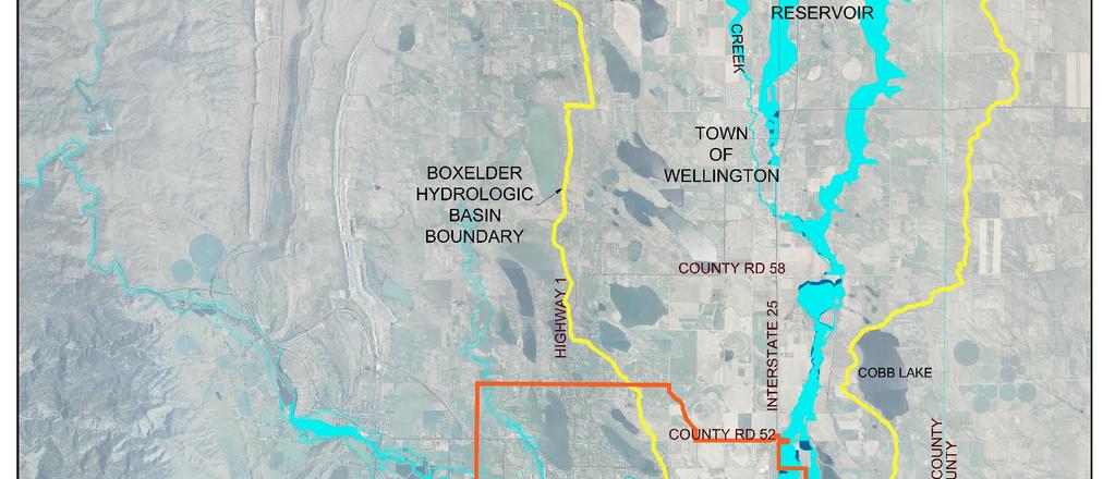
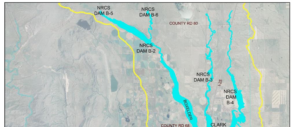
1 DATE: STAFF: January 28, 2014 Ken Sampley, Stormwater/Floodplain Program Mgr Jon Haukaas, Water Engr Field Operations Mgr WORK SESSION ITEM City Council SUBJECT FOR DISCUSSION Boxelder Basin Regional Stormwater Authority Update. EXECUTIVE SUMMARY Boxelder Basin Regional Stormwater Authority (BBRSA) was formed by Intergovernmental Agreement (IGA) in 2008 with the purpose of funding and implementing regional stormwater improvements. BBRSA Members include Fort Collins, Larimer County, and Wellington. Timnath is a financial partner by separate IGA with the BBRSA. There are three remaining projects scheduled for completion by July 2015 with an estimated total cost of $11.75 million: (1) Construction of a detention facility on the east side of I-25; (2) a flood control crossing of the Larimer & Weld Canal; and (3) improvements to CR52 to prevent road overtopping. The BBRSA has received low interest loans from the Colorado Water Conservation Board (CWCB) that can be used for property acquisition and regional stormwater project design and construction costs. A new IGA is required between Fort Collins, Larimer County and Timnath to fund a portion of the costs associated with improvements at County Road 52. The three parties have agreed to share equally in splitting the estimated ($1.04 Million). The updated Benefit/Cost Ratio for the BBRSA projects is Such a high B/C ratio demonstrates the dramatic benefits of these regional improvements. GENERAL DIRECTION SOUGHT AND SPECIFIC QUESTIONS TO BE ANSWERED This item provides background information and the current status of the Boxelder Basin Regional Stormwater Authority (BBRSA). BACKGROUND / DISCUSSION There is a significant amount of background information applicable to this item. That information is provided in the paragraphs below as follows: 1. History of the originating Boxelder Alliance. 2. The initial Boxelder Creek Regional Stormwater Master Plan. 3. Formation of the Boxelder Basin Regional Stormwater Authority (BBRSA). 4. Progression of the Authority and Master Plan since BOXELDER ALLIANCE Early in 2005, stormwater planners in northern Larimer County took a holistic approach to addressing flood hazard and stormwater drainage problems in the Boxelder Creek watershed. The current BBRSA members have been working together for over 8 years. This watershed or basin encompasses over 265 square miles and extends from just north of the Wyoming border to the Poudre River on the south. Attachment 1 shows the entire FEMA mapped Boxelder Creek floodplain from the Poudre River on the south to just below the existing NRCS dams to the north. Because the Boxelder Creek floodplain affects many property owners and several local
2 January 28, 2014 Page 2 governments, intensive efforts were made to develop a regional flood hazard mitigation plan. It should be noted that Coal Creek and Indian Creek both feed into Boxelder Creek near the Town of Wellington. The communities of Fort Collins, Wellington, Timnath, Windsor, and Larimer County all shared a common goal in mitigating the flood hazard posed by Boxelder Creek. The Alliance was formed in early 2005 to develop a regional solution that is more efficient, wide ranging and cost effective than the entities could develop independently. The Alliance members included: Colorado Dept of Transportation (CDOT) Larimer County City of Fort Collins Town of Wellington Town of Timnath Town of Windsor North Poudre Irrigation Company Boxelder Sanitation District New Cache La Poudre Irrigation Company A Private Property Owners Group Colorado Water Conservation Board (CWCB) 2. Boxelder Creek Regional Stormwater Master Plan Representatives of these entities met over a period of two years to consider ways to mitigate flood hazards within the area that is tributary to Boxelder Creek from County Road 70 north of Wellington south to where Boxelder Creek floodwaters join the Cache La Poudre River. The Boxelder Creek 100-Year floodplain impacts approximately 4,900 acres of land within the regional area. While average floodplain velocities and depths are low (depths less than 3 feet and velocities less than 2.5 feet per second), the hazard associated with the flooding is estimated to be high due to the numerous split flows and diversions which occur within the basin. Flow paths are not well defined and the existing channel system and cross culverts are not capable of conveying large quantities of runoff. Numerous roads would overtop during the 100-Year frequency flooding event. Due to the numerous split flows and diversions that occur, the potential for overtopping frequently used roads and the probability of the existing conveyance system to become blocked, there is the potential for loss of life and/or bodily injury during an extreme runoff event. Kevin Houck, Chief of Watershed and Flood Protection for the CWCB have stated that, The Boxelder watershed remains on the Top 10 list of high risk watersheds for the State of Colorado Table ES-1 from the Master Plan summarizes the estimated damages during a 100-year frequency flooding event and is shown below: Boxelder Creek Regional Stormwater Master Plan Table ES-1 Estimated Existing Damages Summary (100-Year Flood) Reach/Entity Est. Present Worth Damages Structures Impacted By Jurisdiction Larimer County/City of Fort Collins $76.9 Million Town of Wellington $29.5 Million Town of Timnath $3.4 Million 50 5 Total $109.8 Million No. of Roads Overtopped It was determined that the best approach to basin wide flood hazard mitigation would be to prepare a common plan for flood mitigation improvements within the Basin. Members of the Alliance pooled funding to prepare a storm water Master Plan for the Boxelder Basin. The resulting Boxelder Creek Regional Stormwater Master Plan (Master Plan) was completed in October The Master Plan recommended the formation of a Stormwater Authority to fund and implement the regional stormwater improvements.
3 January 28, 2014 Page 3 3. BOXELDER BASIN REGIONAL STORMWATER AUTHORITY (BBRSA) On August 20, 2008, the City of Fort Collins (Fort Collins), Larimer County (County) and the Town of Wellington (Wellington) entered into an intergovernmental agreement (IGA) to establish the Boxelder Basin Regional Stormwater Authority (BBRSA). The BBRSA was established to fund and implement the regional stormwater improvements outlined in the Boxelder Regional Stormwater Master Plan. It was anticipated that a CWCB low-interest loan would be obtained for construction of the facilities and would be paid back through monthly fees and charges as well as a system of development fees raised by the Authority from properties located within the Boxelder Creek Drainage Basin. Grants would also be pursued to offset some of the costs associated with the project. Attachment 2 provides a summary description (work to be completed, estimated construction costs, and resulting benefits) of the Boxelder Creek Regional Stormwater Master Plan Phase I regional stormwater projects listed below: Diversion of Coal Creek to Clark Reservoir Edson (East Side) Detention Reservoir Middle Boxelder Creek Stream Improvements Larimer and Weld Crossing Structure. The total funding requirement for the M a s t e r P l a n P h a s e I Regional Stormwater Improvements was $13.7 million (depending on the final design of the Edson Detention Reservoir and available storage). 4. PROGRESSION OF THE BBRSA SINCE 2008 Diversion of Coal Creek to Clark Reservoir The Diversion of Coal Creek to Clark Reservoir (later known as the Coal Creek Flood Mitigation Project) was completed by the BBRSA in cooperation with Larimer County in The project diverts stormwater flows from Coal Creek (which is tributary to Boxelder Creek) into the Clark Reservoir Inlet Canal and ultimately into Clark Reservoir. North Poudre Irrigation Company (NPIC) owns these facilities, which are north of the Town of Wellington. The Inlet Canal was enlarged to accommodate the 1,700 cfs from Coal Creek, Clark Reservoir was dredged and the emergency spillway was raised to accommodate the decreed storage of NPIC along with the diverted Coal Creek flows. During construction, 186,000 cubic yards of sediment was removed from Clark Reservoir. The dredging combined with raising the emergency spillway provides the 540 acre-feet of flood storage along with the 871 acre-feet of decreed storage for NPIC. This project was funded using a FEMA Pre- Disaster Mitigation Grant (PDM), matching local sponsor funds and BBRSA stormwater fees. Benefits of the Coal Creek project are: Storm flows are diverted from Coal Creek into Clark Reservoir which reduces flooding in Wellington; Over 103 Acres of land was removed from the 100-Year floodplain; There were 145 structures within the Wellington 100-Year Floodplain including a grade school and junior high: o 101 structures were removed from the floodplain with the approved LOMR including the two schools; o 31 structures were removed with approved LOMAs; o 13 structures remain in the floodplain because their lowest opening is below the revised BFE; and The FEMA Floodplain maps have already been revised to reflect this reduction in the 100-Year Floodplain. East Side Detention Facility (ESDF) The Boxelder Creek Regional Stormwater Master Plan refers to the East Side Detention Facility as the "Edson Reservoir" and conceptually located it just north of County Road 60. This location would reduce downstream flows by 40-60% as they crossed the east-west roads between County Road 48 and County Road 60. All of these crossings are currently subject to significant overtopping and flooding during a 100-year flood event. As a result, the 100-Year Floodplain would be reduced as well as the size and cost of bridge/culvert crossings at each of the County Roads. It should be noted the plan did not eliminate overtopping of the County Roads. The construction of bridge/culvert crossings to pass the 100-year flood were identified as local improvements in the
4 January 28, 2014 Page 4 Master Plan and were to be funded by Larimer County and private developers as development progressed north towards Wellington. As the site investigation continued it became apparent that the original proposed location could not provide the required detention and would result in the condemnation of homes. When the original site became no longer feasible, the BBRSA decided to move forward with an extensive Siting Study in The goal of this Siting Study was to identify the best location(s) for the proposed ESDF both from a flood reduction perspective and also from a cost and constructability perspective. At least 10 possible sites were evaluated and eliminated based on feasibility. Attachment 3 provides a map and a summary description of the site evaluation process. Once this analysis was completed the BBRSA confirmed the selection of the current site adjacent to the existing Gray Lakes Reservoirs as the best location from flood reduction, cost and constructability perspectives. Timnath Participation Representatives from the BBRSA and the Town of Timnath then began discussions on the possibility of increasing the size of the ESDF to reduce downstream flows. If the outflows from the ESDF can be reduced to approximately 2,500 cfs the City of Fort Collins and the Town of Timnath could consider unplugging two large box culverts at the crossing of Interstate 25 (I-25) and Boxelder Creek. Two of the four box culverts originally constructed at this location have been plugged since they were first built. When FEMA revised the floodplain mapping in this area, the resulting overflow from this blockage extended the floodplain south along the east side of I-25 flooding large sections of Timnath. Opening the two box culverts will eliminate this overflow path. When the BBRSA engineering consultant determined the potential exists to meet this goal, the Town of Timnath expressed interest in participating financially with the BBRSA to achieve this goal. County Roads between CR 48 and CR 60 The relocation of the ESDF downstream to its current proposed location just south of and adjacent to County Road 52 results in a significant reduction in the original benefits of a reduced (narrower) floodplain and shallower overtopping of County roads north of ESDF to County Road 60. In June 2013, an approach was identified to address Larimer County s concerns with regard to County Road 52 which consisted of determining the relative benefits (primarily determined by cost, life safety improvements and transportation corridor access) to Larimer County from proposed stormwater improvements at County Road 52 to those that would have been obtained through implementation of the original Master Plan. The approach determined and compared: the estimated size and cost of improvements at County Road 52 required to convey flood flows under the roadway such that the road overtopping matches what would have occurred had Edson been built at the Master Plan location; the estimated size and cost of improvements needed to convey additional flood flows under County Road 52 in order to meet the County criteria of 6 inches of overtopping; the reduced future costs for Larimer County to address 100-year flood roadway overtopping at County Roads,50 and 48 that would result from the construction of the proposed BBRSA improvements; and, the increased future costs to Larimer County to address 100-year flood roadway overtopping at County Roads 54, 56, 58 and 60 now that the 100-year flood flows are higher than they would have been after construction of a detention facility north of these roadways. On August 10, 2013 a meeting was held with Larimer County Commissioners and representatives of the City of Fort Collins, Town of Wellington, Town of Timnath, and Larimer County staff. The intent of the meeting was to gain consensus on a proposed compromise for addressing the additional costs required to address Larimer County s concerns regarding County Road 52. A solution was reached that results in the need for an additional intergovernmental agreement (IGA) between the City of Fort Collins, Larimer County, and Timnath to share equally (one third each) in providing the approximately $1.04 Million of funds necessary to cover the estimated shortfall once the improvements to County Road 52 are included along with the construction of the ESDF and Larimer/Weld Crossing Structure. BBRSA Master Plan Modifications
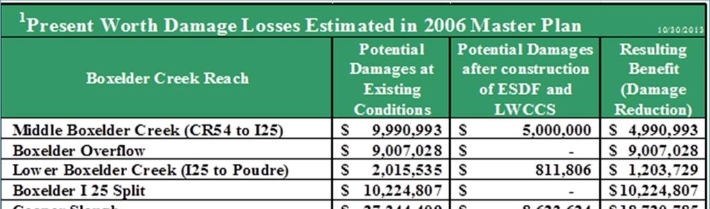
5 January 28, 2014 Page 5 As a result of the above, the improvements as envisioned in the original Boxelder Creek Regional Stormwater Master Plan were modified based on design constraints, construction feasibility and impacts and costs. It is important to note that the original Master Plan was a conceptual document. As is the case with all such efforts, the final design frequently necessitates changes to the original concept as design efforts and site investigations become more refined. It is important to note that the current proposed regional stormwater improvements maintain the original focus of increasing life safety and reducing floodplain extents. The BBRSA Master plan now consists of the remaining regional stormwater projects: East Side Detention Facility (Located adjacent to Gray Lakes Reservoirs); Larimer and Weld Crossing Structure of Boxelder Creek; and, County Road 52 Improvements. FINANCIAL AND SOCIAL IMPACTS The BBRSA stormwater improvements benefit citizens and residents within our region. This section identifies the benefits that the City of Fort Collins will receive as a result of the construction of the remaining BBRSA regional stormwater projects (the East Side Detention Facility, Larimer/Weld Canal Crossing Structure, and County Road 52 Improvements). Updated Benefit / Cost Ratio In light of the BBRSA Master Plan revisions, an update of the estimated Benefit/Cost Ratio of the regional stormwater projects was completed to confirm the financial benefits. The table below uses information on damage losses from the 2006 Boxelder Creek Regional Stormwater Master Plan and compares the losses with the current estimated construction costs for the remaining BBRSA projects (ESDF, LWCCS, and CR52 Improvements). 1 Present Worth Damage Losses Estimated in 2006 Master Plan 10/30/2013 Boxelder Creek Reach Potential Damages at Existing Conditions Potential Damages after construction of ESDF and LWCCS Resulting Benefit (Damage Reduction) Middle Boxelder Creek (CR54 to I25) $ 9,990,993 $ 5,000,000 $ 4,990,993 Boxelder Overflow $ 9,007,028 $ - $ 9,007,028 Lower Boxelder Creek (I25 to Poudre) $ 2,015,535 $ 811,806 $ 1,203,729 Boxelder I 25 Split $ 10,224,807 $ - $ 10,224,807 Cooper Slough $ 27,344,409 $ 8,623,624 $ 18,720,785 Cache La Poudre Overflow $ 2,311,180 $ 220,493 $ 2,090,687 Totals $ 60,893,952 $ 14,655,923 $ 46,238,029 2 Current Construction Cost Estimate (ESDF, LWCCS& CR 52 Imprvmts) $ 11,700,000 Estimated Benefit/Cost Ratio Source: Table C-3 Appendices BOXELDER CREEK REGIONAL STORMWATER MASTER PLAN October Initial Total Costs to be offset by Authority Revenue & TDA contributions & Additional Funding from New IGA Review of the table shows an updated Benefit/Cost Ratio of In most instances, a B/C ratio of 1.5 or 2 is considered very good. Such a high B/C ratio is very unusual and demonstrates the dramatic benefits that construction of the BBRSA projects has with regard to the reduction in damages from a 100-Year flood event. Summary Fort Collins Benefits There are significant financial benefits and reductions in flood damage to properties located with the City of Fort Collins and its GMA as shown in the summary table below.
 in the Larimer and Weld Irrigation Canal and spill down the")
6 January 28, 2014 Page 6 Cooper Slough The BBRSA regional stormwater projects will eliminate the westerly Boxelder Creek overflow on that extends south along the east side of Interstate Highway 25. The Cooper Slough will benefit by a dramatic reduction in 100-Year flood flows that currently cross beneath Interstate Highway 25 (I-25) in the Larimer and Weld Irrigation Canal and spill down the Cooper Slough Drainageway. There are significant benefits to Fort Collins as outlined below: Fort Collins saves $11.3 Million in reduced stormwater infrastructure costs on the Cooper Slough area alone; Approx. 130 acres of land will be removed from the 100-year floodplain; Reductions in flood damages for approximately 90 existing commercial and residential structures (northwest corner of Mulberry and I-25); The commercial buildings at the southwest corner of Mulberry and I-25 will also see reductions in flood damage; Significantly reduces the size and quantity of the proposed stormwater infrastructure in the area of Cooper Slough and Mulberry; and, 100-Year flows in Cooper Slough will be reduced from approx cfs to 780 cfs. Boxelder Creek The BBRSA regional stormwater projects will eliminate the westerly Boxelder Creek overflow that extends south along the east side of Interstate Highway 25. The ESDF facility will reduce the 100-Year Flood flows to approximately 2,500 cfs. With Fort Collins and Timnath agreeing to jointly fund and construct improvements near and upstream of the Boxelder Creek crossing of Prospect Road, the two large box culverts at the crossing of Interstate 25 (I-25) and Boxelder Creek can be unplugged. When FEMA revised the floodplain mapping in this area, the resulting overflow from this blockage extended the floodplain south along the east side of I-25 flooding large sections of Timnath. Opening the two box culverts will eliminate the current Boxelder Creek overflow floodplain that extends south along the east side of I-25 and floods large sections of Timnath. There are significant benefits to Fort Collins as outlined below: A $6 million savings for roads within the Fort Collins GMA (County Roads 54, 52, 50, 48 and State Highway 14); A $2.1 million savings for stormwater improvements at Boxelder Creek and Prospect Road. Approx. 650 acres of land with the Fort Collins GMA will be removed from the 100-Year floodplain; Approx. 1,630 acres of land for the reach of Boxelder Creek below County Road 52 will be removed from the 100-Year Floodplain. Upon completion of all projects, the Boxelder overflow 100-Year floodplain through Timnath will be eliminated. There is a reduction of flood damages for existing properties.
7 January 28, 2014 Page 7 Road Crossings of Boxelder Creek - County Road 52 Intergovernmental Agreement (IGA) The current estimated cost of the ESDF, LWCCS and CR 52 Improvements is $11,748,274. After subtracting loan origination fees, the total amount of available funding for the three CWCB loans is $8,910,000. The BBRSA and TDA will contribute revenue and participating funds, respectively, during the design and construction of ESDF and LWCCS in the amount of $1,800,000. That leaves an estimated shortfall of $1,038,274. Fort Collins, Larimer County and Timnath agreed to share equally in providing the necessary funds to the BBRSA to cover this estimated shortfall. The legal counsel for the BBRSA discussed the proposed County Road 52 IGA with attorneys from each of the member entities. The draft County Road 52 IGA has been distributed to the attorneys for review and final changes. Larimer County will need to adopt the ordinances for both the First Amendment to the IGA and this new cost sharing IGA while Fort Collins and Timnath will need to adopt the ordinance establishing the new cost sharing IGA. Approval of the new County Road 52 IGA is scheduled for the February 18, 2014 City Council Meeting. FUNDING STATUS Timnath and BBRSA Intergovernmental Agreement (IGA) Timnath has executed an intergovernmental agreement with the BBRSA to initially provide $500,000 and then fund 25% (approximately $2.5 Million) of the costs to design and construct the ESDF and LWCCS. First Amendment to Boxelder Basin Regional Stormwater Authority (BBRSA) IGA With an agreement in place with Timnath, the BBRSA moved forward with the First Amendment to the original IGA which formed BBRSA. According to Section 2.05 (f) of the IGA, all member entities must agree to the issuance of debt by the BBRSA. The Amendment approved the issuance of debt based on the CWCB loan applications for ESDF and LWCCS which were submitted on April 1, This amendment has been approved by the City of Fort Collins and the Town of Wellington and awaits approval by Larimer County. CWCB Loan Status The two original CWCB loan application and feasibility studies for ESDF and LWCCS were applied for on April 1, These loans were approved by the CWCB Board at its meeting on May 14, The final loan contracts were received on July 11, The review and execution of these contracts are currently on hold pending execution of the First IGA Amendment by Larimer County and the execution of the New IGA between the City of Fort Collins, Larimer County, the Timnath Development Authority and the BBRSA. The third CWCB loan application and feasibility study for a portion of the County Road 52 Improvements was submitted to CWCB on November 1, This package is scheduled to appear before the CWCB Board on January 27, Staff from the CWCB has confirmed that the CWCB funds are available for land acquisition but cannot be used for the legal costs associated with the condemnation process. Eminent Domain The power of eminent domain for the BBRSA stems from two independent sources: The BBRSA is created pursuant to C.R.S and C.R.S , which allows any combination of municipalities, special districts and other political subdivisions of the states, which includes counties, to form a water resources or drainage authority through contract between the parties for the purpose of developing water resources or drainage facilities. The BBRSA Intergovernmental Agreement is also the type of agreement authorized by C.R.S One of the powers granted by the signatories is the power to condemn property for public use (IGA Article III, Section 3.01(f). Since the power to condemn property for water and drainage purposes is common to all of
 Status The BBRSA is in the process of negotiating the acquisition of land from impacted properties. Letters of Intent to Acquire have been issued to property owners.")
8 January 28, 2014 Page 8 the signatories to the IGA, the BBRSA may exercise the power to condemn any interest in property, including a fee interest. Real Estate (Land Acquisition) Status The BBRSA is in the process of negotiating the acquisition of land from impacted properties. Letters of Intent to Acquire have been issued to property owners. If negotiations fail, the BBRSA Board of Directors may need to exercise its condemnation powers. The BBRSA Board of Directors must vote in order to exercise the use of eminent domain. SCHEDULE The latest updated schedule for completion of the BBRSA regional stormwater improvements is: SPECIFIC ISSUES AND INQUIRIES Over the last couple of months, there have been specific inquiries pertaining to the purpose of the BBRSA and its ability and legal authority to proceed with the steps necessary to design and construct the regional stormwater improvements. Legal authorities and funding considerations of the BBRSA include: Article V of the IGA authorizes the BBRSA to establish rates and collect stormwater fees and charges on property within the BBRSA service area. Article V of the IGA specifically states that the BBRSA members have the option to pay the BBRSA directly in lieu of having the BBRSA collect stormwater fees. Fort Collins has properly budgeted for the payment of these fees as part of its normal budgeting cycle. The BBRSA has the legal authority to acquire real estate by eminent domain through the process of condemnation (C.R.S and C.R.S ). The BBRSA has received low interest loans from the Colorado Water Conservation Board (CWCB) that can be used for property acquisition and regional stormwater project design and construction costs.
9 January 28, 2014 Page 9 The BBRSA has received low interest loans from the Colorado Water Conservation Board (CWCB) that can be used for property acquisition and regional stormwater project design and construction costs. A detailed listing of the issues and responses is provided in Attachment 4. Previous sections of this report addressed issues regarding: the purpose and benefits of the BBRSA; the rationale for the East Side Detention Pond Siting; Approval of CWCB Loans; Legal authority to issue debt; and BBRSA s authority to use eminent domain. ATTACHMENTS 1. FEMA Mapped Boxelder Creek Floodplain (PDF) 2. Boxelder Creek Regional Stormwater Master Plan -- Phase I Project Summaries (PDF) 3. Boxelder Basin Regional Stormwater Authority -- ESDF Siting Study Summary (PDF) 4. BBRSA -- Specific Issues and Responses (PDF) 5. BBRSA Resolutions and (Stormwater Service and System Development Fees) (PDF) City of Fort Collins Budget Excerpt (Boxelder Basin Regional Stormwater Authority Funding) (PDF) 7. Powerpoint presentation (PDF)

10 FEMA Mapped Boxelder Floodplain ATTACHMENT 1
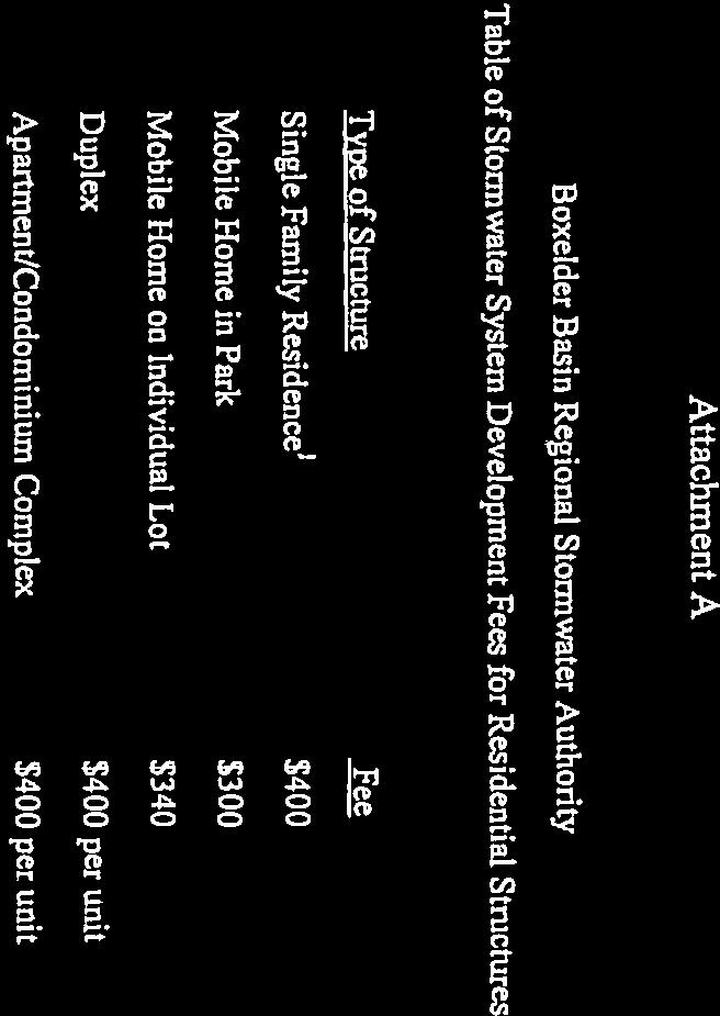
11 BOXELDER CREEK REGIONAL STORMWATER MASTER PLAN PHASE I REGIONAL PROJECTS Project Summaries ATTACHMENT 2 DIVERSION OF COAL CREEK TO CLARK RESERVOIR Description: Improvement of the North Poudre Canal to capture and convey Coal Creek flood flows easterly into Clark Reservoir, dredging of Clark Reservoir to provide for flood storage volume, agreement with North Poudre Irrigation Company to preserve flood storage capacity with the reservoir, spillway and outlet works improvements, and associated land acquisition. Estimated Construction Costs: $6.2 Million Benefits: Reduces peak discharges downstream (approximately 90% in n Coal Creek; 5-10% in Boxelder Creek) via attenuation in Clark Reservoir, reduces floodplain ex tents by approximately acres; minimizes flooding potential and damages for approximately 180 structures (including 2 schools, community center, residential and commercial structures) EDSON (EAST SIDE) DETENTION RESERVOIR Description: Construction of an earthen embankment and un-gated outlet to impound 660 to 990 acre-feet of storage on Indian Creek just upstream of County Road 60; potential diversion of storm flows at the Boxelder/I-25 split flow location, and associated land acquisition. Estimated Construction Costs: $4.1 to $6.1 Million (Used $5.1 for cost estimates) Benefits: Significantly reduces peak discharges downstream (approximately 40-60%) via attenuation of flood flows in the new Edson Detention Reservoir, minimizes sizes of required downstream conveyance improvements, reduces floodplain extents and potential for downstream split flood flows, minimizes flooding potential and damages to approximately 165 existing structures within Larimer County and Fort Collins. MIDDLE BOXELDER CREEK STREAM IMPROVEMENTS Description: Improved stormwater conveyance and associated stream improvements to the Middle Boxelder Creek section from County Road 52 to County Road 52; construction of two storm drainage channels to direct flow to Boxelder Creek. Estimated Construction Costs: $1.1 Million Benefits: Reduces potential for overflow and split flood flows adjacent to I-25, reduces impacts to Cooper Slough, removes approximately 535 acres of the Boxelder Overflow flood plain (in conjunction with Edson Detention Reservoir); provides potential trail and recreational opportunities. LARIMER AND WELD CROSSING STRUCTURE Description: Construct a siphon or spill structure at the Boxelder Creek/Larimer and Weld crossing to protect the irrigation canal and allow flood flows to continue south in Boxelder Creek. Estimated Construction Costs: $1.3 Million Benefits: Reduces potential overtopping of the Larimer and Weld irrigation canal and diversion of flood flows west beneath I-25 to the Cooper Slough drainageway. The total funding requirement for the M a s t e r P l a n P h a s e I Regional Stormwater Improvements was $13.7 million (depending on the final design of the Edson Detention Reservoir and available storage). 1 of 1
12 BOXELDER BASIN REGIONAL STORMWATER AUTHORITY EAST SIDE DETENTION FACILITY (ESDF) Siting Study Summary ATTACHMENT 3 BACKGROUND The Boxelder Creek Regional Stormwater Master Plan refers to the East Side Detention Facility as the "Edson Reservoir" and conceptually located it just north of County Road 60. This location would reduce downstream flows by 40-60% as they crossed the east-west roads between County Road 48 and County Road 60. All of these crossings are currently subject to significant overtopping and flooding during a 100-year flood event. As a result, the 100-Year Floodplain would be reduced as well as the size and cost of bridge/culvert crossings at each of the County Roads. It should be noted the plan did not eliminate overtopping of the County Roads. The construction of bridge/culvert crossings to pass the 100-year flood were identified as local improvements in the Master Plan and were to be funded by Larimer County and private developers as development progressed north towards Wellington. EAST SIDE DETENTION FACILITY SITING STUDY As the site investigation continued, it became apparent that the original proposed Edson Reservoir location could not provide the required detention and would result in the condemnation of homes. When the original site became no longer feasible, the BBRSA decided to move forward with an extensive Siting Study in The goal of this Siting Study was to identify the best location(s) for the proposed ESDF both from a flood reduction perspective and also from a cost and constructability perspective. At least 10 possible sites shown on the attached map were evaluated and eliminated based on feasibility. A detailed description of the process and outcome is included in the BBRSA s applications to the Colorado Water Conservation Board (CWCB) dated April 1, 2013 requesting loans to construct the regional stormwater improvements (ESDF and LWCCS). The relocation of the ESDF downstream to its current proposed location just south of and adjacent to County Road 52 results in a significant reduction in the original benefits of a reduced (narrower) floodplain and shallower overtopping of County roads north of ESDF. Each site was evaluated based on the available floodwater storage, hydrologic benefits to downstream flow rates, and impacts to existing homes/structures. A principal goal was to keep the 100 year flows within the main channel of Boxelder Creek which would eliminate the split flow or westerly floodplain of Boxelder Creek (shown on Exhibit A adjacent to I-25 between CR52 and Mulberry Street), which greatly reduces the flood damage risk to people and property. The main channel of Boxelder Creek can convey approximately 2,900 cfs. Using the 2,900 cfs as a target for downstream flows, six of the alternatives were eliminated from further consideration due to their inability to reduce flood flows to the target discharge within the Middle Basin (County Road 50 to Mulberry Street). Additional factors contributing to the elimination of these six alternatives included the inundation of homes, site constraints that limited potential storage volume, and/or the reservoirs location relative to Boxelder Creek. One alternative site was located on the existing CSU Agricultural Research and Development Center or ARDEC. After the publication of the 2010 Siting Study for Edson Reservoir, the Authority manager and Ayres engineers met with staff from ARDEC to determine their willingness to allow the construction of a flood mitigation dam just north of County Road 56 on their property. Ayres prepared a preliminary grading plan for the dam, along with several cross sections through the dam, so they could see the impact to their existing center pivot and grazing area for their cattle which they keep on-site. The proposed facility has significant impacts on ARDEC s day to 1 of 3
13 BOXELDER BASIN REGIONAL STORMWATER AUTHORITY EAST SIDE DETENTION FACILITY (ESDF) Siting Study Summary day operations both during construction of the dam and afterwards. A suggestion was made to investigate the site south of ARDEC between CR 54 and CR 56 which is currently owned by the City of Thornton. BBRSA representatives and Larimer County Staff met with the City of Thornton to investigate the potential siting of the ESDF on land it owns north of County Road 54. The BBRSA engineer prepared a preliminary grading plan and cross sections for a dam which achieved the downstream residual flow targets. The City of Thornton stated its objection to a proposed detention facility due to its plans to construct a water storage facility and/or potential pumping station on the site. The BBRSA then contacted the Larimer Canal Reservoir Company (the owners of the Gray Lakes Reservoirs) and looked again at using the Gray Lakes site for the proposed ESDF. The site design for this site was modified from the Siting Study alternative to provide a dam just north of CR 50 on the west side of the existing Gray Lakes dams. The difference between this alternative and a previous alternative is there would be no storage of water in the existing Gray Lakes on top of their normal pool elevation. Prior to beginning the final design for the current ESDF option, Ayres Associates, met with Michael-Baker (as representatives of FEMA) to confirm that the proposed portion of the dam which is located just south of CR 52 and runs parallel to CR 52 would not be considered a levee by FEMA. This was a significant cost savings to the project. As part of the preliminary design process Ayres has also completed a fatal flaw analysis of the proposed design. Once this analysis was completed the BBRSA confirmed that this site provided the best location from a flood reduction perspective and also from a cost and constructability perspective. 2 of 3
 Siting Study Summary 3")
14 BOXELDER BASIN REGIONAL STORMWATER AUTHORITY EAST SIDE DETENTION FACILITY (ESDF) Siting Study Summary 3 of 3
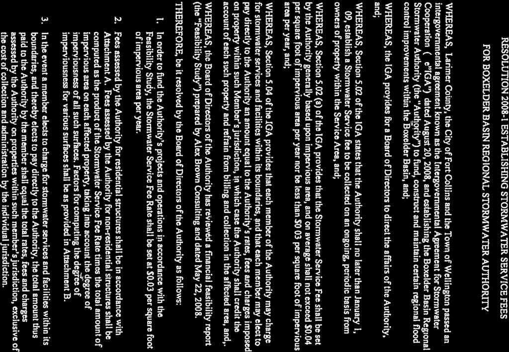
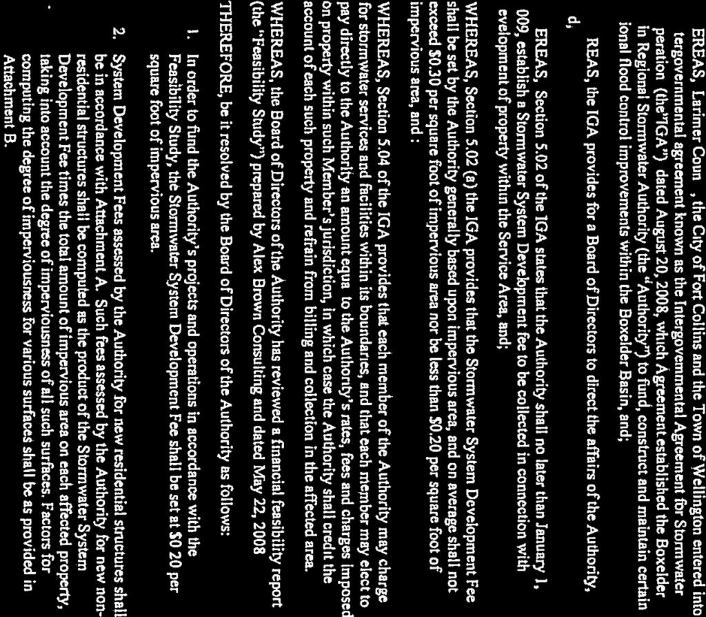
15 BOXELDER BASIN REGIONAL STORMWATER AUTHORITY SPECIFIC ISSUES AND RESPONSES Specific Issues and Responses Summary Listing ATTACHMENT 4 Issue: The BBRSA was only established to allow more development in the region. Response: Flooding and stormwater drainage problems have long plagued the Boxelder Creek watershed, particularly the developing area from just north of the Town of Wellington, Colorado to just south of Timnath, Colorado. Major floods have occurred in 1909, 1922, 1930, 1937, 1947, 1963, 1967 and In 1947, the Fort Collins Coloradoan included a headline that read "Violent Rainstorm Floods Large Area; Crop Losses Heavy". As much as five (5) inches of rain fell northwest of Wellington, washing out bridges and flooding crops. Nearly 1,000 acres of grain, alfalfa and corn crops were damaged. Heavy rains caused Boxelder Creek to overflow its banks again in 1967 and resulted in the death of a mother and her three daughters. The woman and her daughters drove into the flooded creek where it passed over a county road southwest of Wellington. Floods that summer destroyed county bridges seven times. The BBRSA was established to protect life safety, reduce 100-Year floodplain extents, protect existing structures (including schools and critical facilities), protect existing residences and businesses, reduce flood overtopping of 33 roads and 4 irrigation canals, reduce the costs to construct new stormwater infrastructure, improve emergency response, and reduce flooding on currently undeveloped areas that will be developed in the future. Issue: The BBRSA does not have the legal authority to collect stormwater service and plant investment fund (PIF) fees. Response: Article V of the BBRSA Intergovernmental Agreement outlines the provisions by which the BBRSA is authorized and required to impose rates, fees and charges on property within the BBRSA Service Area to fund the regional stormwater improvements. Issue: The BBRSA does not have the legal authority to acquire real estate by eminent domain through the process of condemnation. Response: The power of eminent domain for the Authority stems from two independent sources. The Authority is created pursuant to C.R.S and C.R.S , which allows any combination of municipalities, special districts and other political subdivisions of the states, which includes counties, to form a water resources or drainage authority through contract between the parties for the purpose of developing water resources or drainage facilities. See C.R.S (1). By entering into the Intergovernmental Agreement for Stormwater Cooperation and Management ( Agreement ), the City of Fort Collins, the Town of Wellington and Larimer County formed the Authority in conformance with C.R.S It should also be noted that the Agreement is also the type of agreement authorized by C.R.S for the formation of an intergovernmental authority. The Authority also has an independent power of condemnation as a result of its creation as an intergovernmental entity pursuant to C.R.S C.R.S allows counties and municipalities to contract with one another to create governmental entities to carry out agreed- upon functions. As pointed out previously, the Agreement is the type of contract contemplated by C.R.S One of 1 of 3
16 BOXELDER BASIN REGIONAL STORMWATER AUTHORITY SPECIFIC ISSUES AND RESPONSES Summary Listing the powers granted by the signatories is the power to condemn property for public use. Agreement, Art. III, Section 3.01(f). This power includes the ability to acquire any interest in property, including a fee interest. As pointed out in Durango Transportation, Inc.v. City of Durango, 824 P.2d 48 (Colo. App. 1991), when an entity is created by governmental agreement, it has all of the powers authorized to each of the participants to the agreement. See Durango Transportation at p. 51. Each of the signatories to the Agreement has the power to condemn property for public purposes including drainage. Wellington is a statutory municipality with the power of condemnation granted by C.R.S (1)(a). Larimer County is granted the power to condemn for water and drainage facilities by C.R.S (1)(w). The City of Fort Collins has the power to condemn for public use as granted by Art. IV, Sec. 14 of its Charter. Since the power to condemn property for water and drainage purposes is common to all of the signatories to the Agreement, the Authority may exercise the power to condemn any interest in property. Issue: The BBRSA Board of Directors does not vote to go into executive session. Response: The executive sessions are listed on the agenda for each Board meeting. The Board has voted whether or not to go into Executive Session every time. This is documented in the meeting minutes for every Board meeting. The BBRSA Manager reads the relevant CRS provisions to the Board of Directors prior to every Executive Session. The Executive Session is recorded in accordance with state law. Issue: The City of Fort Collins is violating its Home Rule Charter by paying the debts and liabilities (i.e. stormwater service and PIF fees) of private parties (property owners within the BBRSA Service Area). The City of Fort Collins has not contracted with the BBRSA. Response: Article V, Section 5.04 of the BBRSA Intergovernmental Agreement specifically outlines and states that the BBRSA members have the option to pay the BBRSA directly in lieu of having the BBRSA collect fees. The Intergovernmental Agreement does not deprive any Member of its inherent power to charge for stormwater services and facilities within its boundaries. Issue: The BBRSA Board of Directors never adopted or approved fee schedules. Response: The BBRSA Board of Directors adopted fee schedules for both stormwater service fees and stormwater system development fees by Resolution and Resolution , respectively on December 8, Photocopies of the resolutions are provided as Attachment E. Issue: The City of Fort Collins has not properly budgeted for or audited the funding provided to pay the stormwater service and PIF fees to the BBRSA. Response: The City has budgeted for the payment of these fees to the BBRSA as part of its normal budgeting cycle. Please reference Attachment F which shows that the BBRSA funds were included in the City s Budgeting for Outcomes process. 2 of 3
17 Issue: BOXELDER BASIN REGIONAL STORMWATER AUTHORITY SPECIFIC ISSUES AND RESPONSES Summary Listing The BBRSA has not followed proper statutes because it has issued Letters of Intent to acquire and is proceeding with condemnation and it has not voted to proceed with condemnation. Response: The BBRSA Board has not started condemnation proceedings. It does not have to vote prior to sending the Notices of Intent to acquire. If negotiations fail, or if it appears that they will, the BBRSA Board would have to vote prior to proceeding with the use of eminent domain. Issue: The BBRSA regional stormwater improvement projects are taking a substantial amount of agricultural land out of production. Response: This is inaccurate. The only project that directly impacts agricultural land is the East Side Detention Facility (now known as the Gray Lakes Detention Facility). The existing Day parcel comprises 205 Acres, of which 192 acres are farmland. Approximately 149 Acres of the parcel is currently in the 100-Year floodplain. Construction of the detention reservoir requires the acquisition of 57 Acres which reduces the amount of land available for agricultural use to 135 Acres. All of the remaining agricultural land will have been removed from the 100-Year floodplain and will not be subject to flood damage during a storm event. It is also important to note that the same land could also be developed on in the future if the property owner so chooses. Issue: The CWCB will not approve the proposed loans to the BBRSA because the BBRSA must already own the property in fee simple. CWCB loans cannot be used for property acquisition. Response: This is inaccurate. The CWCB has confirmed that funds are available for land acquisition but cannot be used for the legal costs associated with the condemnation process. Further discussions are anticipated with CWCB in early January 2014 to clarify and finalize the loan funding approach and process. Issue: The BBRSA is no longer following the original Master Plan and therefore the proposed improvements are not in alignment with the original intent. Response: This is inaccurate. It is important to note that the Original Master Plan was a conceptual document. The potential use of the Gray Lakes site (upstream of County Road 50) is actually included in the original Boxelder Creek Master Plan as Alternative 5. The Selected Alternative (5A) from the Master Plan proposed the regional detention storage be located at the Edson Reservoir location upstream of County Road 60. During the course of design, it was determined that the improvements as originally envisioned in the original Master Plan would need to be modified based on design constraints, construction feasibility and impacts and costs. As is the case with all such efforts, the final design sometimes necessitates changes to the original concept as design efforts and site investigations become more refined. As a result, the final proposed use of the Gray Lakes site for construction of the regional detention facility both meets the physical constraints and is in keeping with the alternative solutions outlined in the original Master Plan. 3 of 3
18 ATTACHMENT 5

19

20

21
22
23
24

25
26 ATTACHMENT 6 Packages and Offers SAFE COMMUNITY Budget Years: Boxelder Basin Regional Stormwater Authority - Funded $255, $265,000 The Boxelder Basin Regional Stormwater Authority (BBRSA) was established in 2008 by an intergovernmental agreement (IGA) among the City of Fort Collins, Larimer County and the Town of Wellington. The BBRSA is managed by a 5-member Board of Directors. Each government appoints one director, and there are two jointly-appointed directors (Fort Collins/Larimer County and Wellington/Larimer County). Each government provides financial and staff support to the BBRSA, which includes annual stormwater fees. This offer provides funding for the City's 2013 and 2014 annual payment of stormwater service fees and plant investment fees to the BBRSA. The Boxelder Basin Regional Stormwater Master Plan was adopted and an IGA created to design and construct stormwater improvements to address flood mitigation and protection within the Boxelder and Cooper Slough stormwater drainage basins Police Administration - Funded $857, $873,561 This offer funds the salary, benefits and associated costs for the seven positions housed in Police Administration, including the Chief of Police, Assistant Chief, and the department's administrative staff. Note: The Northern Colorado Drug Task Force pays 25% of a finance position because Fort Collins Police is the fiscal manager for the Task Force Police Logistics - Funded $213, $215,559 This offer funds the shared department logistical expenses for Police Services. Such expenses include: copy machine rental, postage, tuition reimbursement, dry cleaning services, summons forms, and office supplies, which allow Police to provide high-quality, efficient community service Police Hiring and Ongoing Training - Funded $843, $861,349 This offer funds personnel and functions of the Training Unit, which includes one sergeant, three officers, a police supply technician, an administrative assistant and a part-time hourly position that is responsible for the maintenance of the indoor firearms range. Associated non-personnel operational costs include: Training Unit, Firearms, Indoor Firearms Range, Defensive Tactics, and Hiring/Promotional. The Training Unit and Internal Affairs (Offer 192.2) comprise the Professional Standards unit that reports to the Professional Standards Lieutenant. This unit coordinates all sworn and non-sworn training, recruitment, selection and hiring, promotional processes, and certification maintenance, and serves as the custodian for all agency training records. The indoor shooting range budget includes the cost of ammunition for the entire agency. 296
27 Boxelder Basin Regional Stormwater Authority (BBRSA) City Council Work Session January 28, 2014 UPDATE 1
28 BBRSA Executive Summary Boxelder Basin Regional Stormwater Authority 2008 Intergovernmental Agreement (IGA) Members Fort Collins, Larimer County, and Wellington. Timnath is a financial partner (Separate IGA with the BBRSA) Three remaining projects $11.75 Million 1. East Side Detention Facility (ESDF) 2. Larimer & Weld Canal Crossing Structure (LWCCS) 3. County Road 52 Improvements (CR 52) Colorado Water Conservation Board (CWCB) loans CR 52 IGA Fort Collins/Larimer/Timnath to share equally in splitting additional costs ($1.04 Million) Very high Benefit/Cost Ratio

29 3 Boxelder Creek Existing 100-Year Floodplain

30 Boxelder Alliance Since 2005 (8 years) Potential Loss of life Roads overtop Floodplain impacts 4,900 Acres Split flows & diversions Boxelder Creek Regional Stormwater Master Plan The Boxelder watershed remains on the Top 10 list of high risk watersheds in the State of Colorado Kevin Houck, CWCB Chief of Watershed and Flood Protection 4
31 Boxelder Creek Regional Stormwater Master Plan (October 2006) Boxelder Creek Regional Stormwater Master Plan Table ES-1 Estimated Existing Damages Summary (100-Year Flood) Reach/Entity Est. Present Worth Damages Structures Impacted No. of Roads Overtopped By Jurisdiction Larimer County/City of Fort Collins $76.9 Million Town of Wellington $29.5 Million Town of Timnath $3.4 Million 50 5 Total $109.8 Million
32 Boxelder Creek Regional Stormwater Master Plan (October 2006) REGIONAL STORMWATER PROJECTS -- PHASE 1 Diversion of Coal Creek to Clark Reservoir Edson (East Side) Detention Reservoir Middle Boxelder Creek Stream Improvements Larimer and Weld Crossing Structure 6
 v Purpose fund and implement the regional stormwater improvements.")
33 Boxelder Basin Regional Stormwater Stormwater Authority (BBRSA) v August 20, 2008 (Fort Collins, Larimer County and Wellington) v Purpose fund and implement the regional stormwater improvements. v SW improvements benefit the citizens of Fort Collins 7

34 8 Boxelder Basin Regional Stormwater Stormwater Authority (BBRSA)
 by Letters of Map Revision (LOMRs) Another 31 structures were removed from the 100-Year Floodplain by approved Letters of Map Amendments")
35 COAL CREEK FLOOD MITIGATION PROJECT BENEFITS 103 Acres of land (shown in red) removed from the 100-Year Floodplain 101 structures were removed from the 100-Year Floodplain (includes 2 schools) by Letters of Map Revision (LOMRs) Another 31 structures were removed from the 100-Year Floodplain by approved Letters of Map Amendments (LOMAs) 9
36 Boxelder Basin Regional Stormwater Stormwater Authority (BBRSA) Jan 17, 2013 BBRSA Government Partners Joint Meeting 10
37 Boxelder Basin Regional Stormwater Stormwater Authority (BBRSA) Master Plan Revisions Updated Master Plan and Key Considerations include: East Side Detention Facility (ESDF) Introduction Feasibility Studies and Siting of the ESDF Timnath Financial Participation, Related Projects, CWCB Loan, IGA's County Roads between CR48 and CR60 New IGA Between Fort Collins, Larimer County and Timnath (TDA) 11
38 BBRSA Benefits/Costs 12
39 Sources * City of Fort Collins Selected Plan for Boxelder creek/cooper Slough, ACE, April 2004 ** Boxelder Creek Regional Stormwater Master Plan, PBS&J, October 2006 *** Boxelder Creek Regional Stormwater Master Plan, PBS&J, October 2006 for County Roads 54, 52, 50, 48 and SH 14 (All are with the GMA) **** Construction cost estimate by Garney, December Location Cooper Slough at Mulberry Boxelder Creek at Prospect Road Road Crossing Improvements on Boxelder creek City of Fort Collins Benefits City of Fort Collins Master Plan Project Costs without ESDF City of Fort Collins Master Plan Project Costs with ESDF Savings with ESDF in place $15,300,000* $4,000,000** $11,300,000 $6,100,000** $4,000,000**** $2,100,000 $6,000,000*** $0 $6,000,000 Total $27,400,000 $8,000,000 $19,400,000

40 Fort Collins Benefits -- Cooper Slough BENEFITS $11.3 Million Savings Removes approx. 130 Acres from floodplain Reduces floodplain damages 90 structures N. of Mulberry Properties S. of Mulberry 14
 1630 Acres (Boxelder) Eliminates")
41 Fort Collins Benefits Boxelder Creek BENEFITS $6 Million Savings (CR 54, 52, 50, 48 and S.H. 14) $2.1 Million savings -- Boxelder Creek/Prospect Rd Removes from Floodplain 650 Acres (GMA) 1630 Acres (Boxelder) Eliminates Boxelder Overflow Floodplain 15
42 Boxelder Basin Regional Stormwater Stormwater Authority (BBRSA) EAST SIDE DETENTION "Edson Reservoir" site Reduction of downstream flows at County Roads Original site insufficient detention volume and would require condemnation of homes East Side Detention Facility (ESDF) 16
43 Boxelder Basin Regional Stormwater Stormwater Authority (BBRSA) EAST SIDE DETENTION 2010 Siting Study Over 10 sites See Map AIS -- Detailed description Current location is best site 17
44 Boxelder Basin Regional Stormwater Stormwater Authority (BBRSA) Timnath Participation Existing Blockage of culverts under I-25 Goal Reduce flows such that culverts can be unplugged by increasing size of ESDF Opening the culverts = eliminates Boxelder overflow floodplain through Timnath Timnath IGA with BBRSA $500,000 plus fund 25% (approximately $2.5 Million) of the costs to design and construct the larger ESDF and LWCCS 18
45 Boxelder Basin Regional Stormwater Stormwater Authority (BBRSA) Boxelder / Prospect Road Improvements Amendment to Fort Collins / Timnath IGA Fort Collins saves approximately $4.1 Million: $2.1 Million savings in total estimated project costs (from $6.1 Million to $4 Million). $2.0 Million savings as a result of 50/50 cost share of project costs $1.75 Million of City s share will be freed-up escrow funds 19

46 Boxelder Basin Regional Stormwater Stormwater Authority (BBRSA) County Roads Between CR 48 and CR 60 June 2013 Approach Relative benefits and costs between the two pond sites Exhibit shows a deficit of approximately $800,000 County Road 52 IGA 20
47 Boxelder Basin Regional Stormwater Stormwater Authority (BBRSA) CWCB Loan Status 2 original CWCB loans approved by the CWCB Board on May 14, The third CWCB loan approval is scheduled for January 27, CWCB Staff confirmation that funds will be available after acquiring necessary real estate 21
48 Boxelder Basin Regional Stormwater Stormwater Authority (BBRSA) Issuance of Debt First Amendment to original Boxelder IGA Section 2.05 (f) -- All member entities must agree to the issuance of debt by the BBRSA. Approved issuance of debt based on the CWCB loan applications for ESDF and LWCCS Executed by Fort Collins and Wellington Scheduled for approval by Larimer County 22
49 Boxelder Basin Regional Stormwater Stormwater Authority (BBRSA) Real Estate (Land) Acquisition - Status Negotiations in progress The BBRSA is in the process of negotiating the acquisition of land from impacted properties. Letters of intent to acquire distributed. Eminent Domain only if negotiations fail BBRSA Board of Directors 23
50 Boxelder Basin Regional Stormwater Stormwater Authority (BBRSA) Eminent Domain The AIS describes in detail that the power of eminent domain for the BBRSA stems from two independent sources: 1. BBRSA is authorized to condemn (C.R.S ) 2. Boxelder IGA Provision (C.R.S ) 24
 SCHEDULE")
51 25 Boxelder Basin Regional Stormwater Stormwater Authority (BBRSA) SCHEDULE
52 Boxelder Basin Regional Stormwater Stormwater Authority (BBRSA) RESPONSES TO SPECIFIC INQUIRIES Attachment D of the AIS Memo provides detailed responses to specific inquiries regarding the BBRSA. Previous slides addressed many of the issues including: Purpose and benefits East Side Detention Pond Siting CWCB Loan Approvals Legal authority to issue debt Authority to use eminent domain 26
53 Boxelder Basin Regional Stormwater Stormwater Authority (BBRSA) RESPONSES TO SPECIFIC INQUIRIES Article V -- BBRSA is authorized and required to impose stormwater rates, fees and charges BBRSA Board of Directors Executive Sessions Article V -- Members have the option to pay the stormwater fees directly to BBRSA Fort Collins budgets for these payments BBRSA Stormwater Fee Schedules 27

54 28 DAY PROPERTY PRE-PROJECT

55 29 DAY PROPERTY FLOODPLAIN REMOVED
I. INTRODUCTION. identify long-term capital improvements and rehabilitation measures for the existing drainage system;
 I. INTRODUCTION The Town of Windsor, Colorado is presently experiencing rapid growth and development within the boundaries of several of its major drainage basins. As growth continues within these basins,
When planning stormwater management facilities, the following principles shall be applied where possible.
 2.0 Principles When planning stormwater management facilities, the following principles shall be applied where possible. 2.0.1 Drainage is a regional phenomenon that does not respect the boundaries between
SEMSWA s Role in the Land Development Process
 SEMSWA s Role in the Land Development Process One of SEMSWA s responsibilities is to ensure that any new development or redevelopment within its service area is designed and constructed in compliance with
QUESTIONS AND ANSWERS Windsor Woods, Princess Anne Plaza & The Lakes Combined Drainage Project
 QUESTIONS AND ANSWERS Windsor Woods, Princess Anne Plaza & The Lakes Combined Drainage Project PROJECT OVERVIEW Windsor Woods, Princess Anne Plaza and The Lakes are neighborhoods located in what was once
NAI Principles In Gwinnett County
 NAI Principles In Gwinnett County By Cornelius Ani, LSIT, CFM Contributors: Adena Fullard, P.E., CPSWQ Rudresh Bihalli, P.E., CFM Ken Kagy, P.E., CPESC, CPSWQ Ligia Negru, M. Sc., CFM Maja Radovic, CPESC,
CHECKLIST FOR PHASE II DRAINAGE REPORT
 I. COVER SHEET CHECKLIST FOR PHASE II DRAINAGE REPORT A. Name of Project B. Address C. Owner D. Developer E. Engineer F. Submittal date and revision dates as applicable II. GENERAL LOCATION AND DESCRIPTION
A G E N D A Council Update Training Room September 26, :45 p.m.
 CITY OF THORNTON CITY MANAGER S OFFICE A G E N D A Council Update Training Room September 26, 2017 5:45 p.m. A. Boards and Committees Reports (Estimated 20 Minutes) 1. Rangeview Library District Meeting
City of Waco Stormwater Management Regulations
 1.0 Applicability: City of Waco Stormwater Management Regulations These regulations apply to all development within the limits of the City of Waco as well as to any subdivisions within the extra territorial
Draft Rhode Island Stormwater Design and Installation Standards Manual
 Draft Rhode Island Stormwater Design and Installation Standards Manual Summary The May 2009 Public Review Draft version of the RI Stormwater Design and Installation Standards Manual consists of approximately
QUESTIONS AND ANSWERS Windsor Woods, Princess Anne Plaza & The Lakes Combined Drainage Project
 QUESTIONS AND ANSWERS Windsor Woods, Princess Anne Plaza & The Lakes Combined Drainage Project Project Overview... 2 Thalia Creek (Windsor Woods) Tide Gate... 6 Club House Road Drainage Project... 9 Updated
MASTER DEVELOPMENT DRAINAGE PLAN FOR MONUMENT HEIGHTS
 MASTER DEVELOPMENT DRAINAGE PLAN FOR MONUMENT HEIGHTS DRAINAGE REPORT STATEMENT ENGINEER'S STATEMENT: The attached drainage plan and report were prepared under my direction and supervision and are correct
Overall Drainage Report
 Overall Drainage Report Date: May 3, 2016 Project: Attn: Gateway at Prospect Overall Development Plan Fort Collins, Colorado Mr. Shane Boyle Fort Collins Utilities 700 Wood Street Fort Collins, Colorado
Drexel, Barrell & Co.
 Drexel, Barrell & Co. December 21, 2018 Engineers/Surveyors Boulder Colorado Springs Greeley 3 South 7 th Street Colorado Springs, Colorado 80905-1501 719 260-0887 719 260-8352 Fax El Paso County Planning
EXHIBIT A. Tax Increment Reinvestment Zone No. 1 (Town Center) First Amended Project Plan 1
 First Amended Project Plan 1") EXHIBIT A Tax Increment Reinvestment Zone No. 1 (Town Center) First Amended Project Plan 1 1 As amended by Resolution No. 2008-02-001(TR1R) of the Tax Increment Reinvestment Zone No.1, and approved to
EXHIBIT A Tax Increment Reinvestment Zone No. 1 (Town Center) First Amended Project Plan 1 1 As amended by Resolution No. 2008-02-001(TR1R) of the Tax Increment Reinvestment Zone No.1, and approved to
I. INTRODUCTION. Project Background and Study Area
 I. INTRODUCTION Project Background and Study Area Freedom Parkway is a key east-west corridor connecting I-25 on the west to the Town of Kersey on the east, running approximately one to two miles south
Request for Statement of Interest in Implementation of the Roosevelt Road Redevelopment Plan
 425 Hillside Avenue Request for Statement of Interest in Implementation of the Roosevelt Road Redevelopment Plan I. INTRODUCTION The is seeking the services of a qualified consulting firm to prepare plans
Existing Conditions and Environmental Consequences Floodplains
 3.9 Environmental Consequences 3.8 3.8.1 WHAT ARE FLOODPLAINS? are low-lying areas adjacent to rivers, streams, and other waterbodies that are susceptible to inundation (flooding) during rain events. These
Drexel, Barrell & Co.
 Drexel, Barrell & Co. June 18, 2018 Engineers/Surveyors Boulder Colorado Springs Greeley 3 South 7 th Street Colorado Springs, Colorado 80905-1501 719 260-0887 719 260-8352 Fax El Paso County Planning
5. FINAL DEVELOPMENT PLAN APPROVAL MENORAH MEDICAL CENTER OFFICE BUILDING Vicinity of the southwest corner of 119 th Street and Nall Avenue
 5. FINAL DEVELOPMENT PLAN APPROVAL MENORAH MEDICAL CENTER Avenue 1. APPLICANT: Hoefer Wysocki Architects, L.L.C., is the applicant for this request. 2. REQUESTED ACTION: The applicant is requesting final
Appendix E Preliminary Location Hydraulic Study
 Appendix E Prepared for: State of Alaska Department of Transportation and Public Facilities Prepared by: HDR Alaska, Inc. 2525 C Street, Suite 305 Anchorage, Alaska 99503 February 2014 This page intentionally
Presentation Item C Annotated Model Outline for a Framework for a Green Infrastructure Plan
 Date: August 17, 2016 To: From: Subject: Management Committee Dan Cloak, Consultant Presentation Item C Annotated Model Outline for a Framework for a Green Infrastructure Plan Recommendation: Receive the
VALLEY VIEW POND Q&A. This item will be discussed under the First Reading portion of the agenda at the July 17, 2012 Village Council meeting.
 VALLEY VIEW POND Q&A This item will be discussed under the First Reading portion of the agenda at the July 17, 2012 Village Council meeting. 1. Please provide a history of the pond including Village maintenance
AGENDA ITEM: IOWA. west] that were not FISCAL IMPACT. the City of Clive. STAFF REVIEW. Resolution II. Amendment PREPARED BY: REVIEWED BY:
![AGENDA ITEM: IOWA. west] that were not FISCAL IMPACT. the City of Clive. STAFF REVIEW. Resolution II. Amendment PREPARED BY: REVIEWED BY:](/thumbs/93/112428810.jpg "AGENDA ITEM: IOWA. west] that were not FISCAL IMPACT. the City of Clive. STAFF REVIEW. Resolution II. Amendment PREPARED BY: REVIEWED BY:") AGENDA ITEM: CITY OF WAUKEE, IOWA CITY COUNCIL MEETING COMMUNICATION MEETING DATE: March 7, 2016 AGENDA ITEM: Consideration of approval of a resolution approving Engineering Services Amendment No. 1 with
AGENDA ITEM: CITY OF WAUKEE, IOWA CITY COUNCIL MEETING COMMUNICATION MEETING DATE: March 7, 2016 AGENDA ITEM: Consideration of approval of a resolution approving Engineering Services Amendment No. 1 with
Table of Contents G.1.a Water Resources - Surface Water - Drainage
 Table of Contents G.1.a Water Resources - Surface Water - Drainage 1. INTRODUCTION... 1335 2. ENVIRONMENTAL SETTING... 1335 a. Regional Hydrology... 1335 b. Local Hydrology... 1337 c. On-site Hydrology...
Paul D. Ralph, BES, RPP, MCIP, Commissioner, Development Services Department. Proposed Storm Water Pond Maintenance Fee
 Public Report To: From: Report Number: Development Services Committee Paul D. Ralph, BES, RPP, MCIP, Commissioner, Development Services Department DS-16-211 Date of Report: December 1, 2016 Date of Meeting:
CITY OF HOLLY SPRINGS STORMWATER UTILITY FREQUENTLY ASKED QUESTIONS
 CITY OF HOLLY SPRINGS STORMWATER UTILITY FREQUENTLY ASKED QUESTIONS GENERAL What is a Stormwater Utility and why is it needed in Holly Springs? A Stormwater Utility is an entity responsible for the daily
SOUTH FOX MEADOW STORMWATER IMPROVEMENT PROJECT
 VILLAGE OF SCARSDALE WESTCHESTER COUNTY, NEW YORK COMPREHENSIVE STORM WATER MANAGEMENT SOUTH FOX MEADOW STORMWATER IMPROVEMENT PROJECT In association with WESTCHESTER COUNTY FLOOD MITIGATION PROGRAM Rob
Stormwater Regulations & Considerations Morse Study Area. Pam Fortun, P.E. CFM Senior Stormwater Treatment Engineer Engineering Services Division
 Stormwater Regulations & Considerations Morse Study Area Pam Fortun, P.E. CFM Senior Stormwater Treatment Engineer Engineering Services Division Stormwater Regulations Development Considerations Floodplain
STORMWATER UTILITY FREQUENTLY ASKED QUESTIONS
 STORMWATER UTILITY FREQUENTLY ASKED QUESTIONS What is Stormwater? Stormwater is water that falls to the ground during a precipitation event. When land is undeveloped or covered with vegetative surface,
7th Avenue Creek Master Plan Development Project. City of St. Charles, IL. IAFSM CONFERENCE March 14, 2018 MARKET
 7th Avenue Creek Master Plan Development Project MARKET City of St. Charles, IL IAFSM CONFERENCE March 14, 2018 7 TH AVENUE CREEK PROJECT AREA 2 2008 RAIN EVENT 3 RESIDENTIAL STRUCTURE FLOODING COMMERCIAL
South Bismarck Watershed Model Update and Stormwater Improvement Project
 Preliminary Engineering Report Bismarck Tribune South Bismarck Watershed Model Update and Stormwater Improvement Project City of Bismarck, ND January 2017 14.105.0046 1.0 Executive Summary The focus of
CITY COUNCIL AGENDA REPORT
 CITY COUNCIL AGENDA REPORT Subject: DESIGNATED FLOOD LINE CARROT CREEK Recommendation(s) That Administration bring forward a Land Use Bylaw amendment in October 2014 establishing the Designated Flood Line
13. PRELIMINARY PLAT NO MILLS FARM - Vicinity of the southeast corner of 159 th Street and Quivira Road
 13. corner of 159 th Street and Quivira Road 1. APPLICANT: HNTB Corporation is the applicant for this request. 2. REQUESTED ACTION: The applicant is requesting approval of a preliminary plat for a 383-lot
City of East Point Comprehensive Floodplain Management Program
 City of East Point Comprehensive Floodplain Management GAFM 2012, 7 th Annual Technical Conference Reza Aral, CFM, CPESC (City of East Point, GA) Shayne Wood, P.E. (CDM Smith) March, 28, 2012 Agenda Overview
City of Elmhurst. City of Elmhurst. Storm Sewer System Workshop November 22, 2010
 City of Elmhurst City of Elmhurst Storm Sewer System Workshop November 22, 2010 1 City of Elmhurst Watershed divide (green dashed line) through Elmhurst Area east of divide drains to Addison Creek Area
San Joaquin River Restoration Program Mendota Pool Bypass and Reach 2B Improvements Project. Restoration Goal Technical Feedback Group
 San Joaquin River Restoration Program Mendota Pool Bypass and Reach 2B Improvements Project Restoration Goal Technical Feedback Group March 20, 2014 1:30 pm San Luis and Delta-Mendota Water Authority 842
Chapter 1: General Program Information
 Chapter 1: General Program Information 1.1 Introduction The Montgomery County Stormwater Management Resolution (#03-1-5) was adopted by the County Board of Commissioners on January 22, 2003. The purpose
ACCESS MANAGEMENT REPORT U.S S.H. 1 TO S.H. 14 S.H U.S. 287 TO I-25
 ACCESS MANAGEMENT REPORT U.S. 287 - S.H. 1 TO S.H. 14 S.H. 14 - U.S. 287 TO I-25 Prepared by: City of Fort Collins Transportation Planning 7951 East Maplewood Avenue, Suite 200 210 E. Olive, P.O. Box 580
Article 20 Stormwater Management
 Article 20 Section 20.01 Intent Article 20 The purpose of this Article is to protect the health, safety, and general welfare of the citizens by requiring compliance with accepted standards and practices
FLOODPLAIN USE PERMIT APPLICATION COMMUNITY DEVELOPMENT DEPARTMENT W. Ten Mile Road Novi, MI (248)
") FLOODPLAIN USE PERMIT APPLICATION COMMUNITY DEVELOPMENT DEPARTMENT 45175 W. Ten Mile Road Novi, MI 48375 (248) 347-0415 Office Use Only Permit Number: Date Issued: Processed By: Type of Permit: Date: Project
FLOODPLAIN USE PERMIT APPLICATION COMMUNITY DEVELOPMENT DEPARTMENT 45175 W. Ten Mile Road Novi, MI 48375 (248) 347-0415 Office Use Only Permit Number: Date Issued: Processed By: Type of Permit: Date: Project
VALUE OF URBAN DRAINAGE PLANNING AND FLOOD HAZARD REDUCTION PROJECTS IN THE 2013 FLOOD
 VALUE OF URBAN DRAINAGE PLANNING AND FLOOD HAZARD REDUCTION PROJECTS IN THE 2013 FLOOD ANDREW EARLES, PH.D., P.E. WRIGHT WATER ENGINEERS, INC. & KEN MACKENZIE, P.E., CFM UDFCD October 11, 2013 Water Resources
PRELIMINARY DRAINAGE REPORT LATHAM 200 MMSCFD GAS PROCESSING PLANT
 PRELIMINARY DRAINAGE REPORT LATHAM 200 MMSCFD GAS PROCESSING PLANT LOTS B, RECORDED EXEMPTION 1211-2-1, RECX13-0096 LOCATED IN THE NORTH 1/2 OF SECTION 2, TOWNSHIP 3 NORTH, RANGE 66 WEST, 6 TH PRINCIPAL
RRW Stonebrook, LLC Tentative Map Findings
 RRW Stonebrook, LLC Tentative Map Findings FINDING T1: The request conforms to the Master Plan and zoning ordinances. RELATIONSHIP TO THE MASTER PLAN 1. The respective development is located within an
Leduc Industrial Outline Plan SE W4
 Leduc Industrial Outline Plan SE 1-50-25-W4 Within the North Leduc Industrial ASP Prepared for: Leduc Energy Park Ltd. Prepared by: Stantec Consulting Ltd. File No. 1161 104655 V5 Table of Contents 1.0
STORMWATER GREEN INFRASTRUCTURE AND PLANNING/ZONING BOARDS
 STORMWATER GREEN INFRASTRUCTURE AND PLANNING/ZONING BOARDS Source: Center for Watershed Protection, 2007 Southern Tier Central Regional Planning & Development Board Chemung County Stormwater Team OUTLINE
PCE PRELIMINARY DRAINAGE ANALYSIS REPORT FOR WESTWOOD MIXED USE NEIGHBORHOOD PROJECT 772 NORTH FOREST ROAD TOWN OF AMHERST, ERIE COUNTY, NEW YORK
 PCE PRELIMINARY DRAINAGE ANALYSIS REPORT FOR WESTWOOD MIXED USE NEIGHBORHOOD PROJECT 772 NORTH FOREST ROAD TOWN OF AMHERST, ERIE COUNTY, NEW YORK MAY 19, 2014 Prepared By: Timothy M. Lavocat, P.E., CFM
CHAPTER 12 IMPLEMENTATION
 CHAPTER 12 IMPLEMENTATION The 2010 Town of Denton Comprehensive Plan is intended to capture a vision of the future of Denton. As such, it provides a basis for a wide variety of public and private actions
4. UTILITIES ELEMENT.
 4. UTILITIES ELEMENT. The purpose of this element is to provide for necessary public facilities and services correlated to future land use projections and population demand. Utilities Sub-Elements (A)
Chapter 10 IMPLEMENTATION RECOMMENDATIONS
 Chapter 10 IMPLEMENTATION RECOMMENDATIONS The recommended land use plan presented in the previous chapter provides a design for the attainment of the urban and rural development and open space preservation
WELCOME! 8 8:30 6: TH STREET IMPROVEMENTS. Open House. Presentation & Q&A
 WELCOME! 168 TH STREET IMPROVEMENTS 6:30 Open House 7 8 Presentation & Q&A 8 8:30 Open House WELCOME Todd Pfitzer City of Omaha Engineer Bob Stubbe City of Omaha Public Works Director Jon Meyer Project
C. WATER. 1. Surface Water Runoff. See Section C.3, Flood Hazard/Mudflow Hazard, page Ground Water
 C. WATER 1. Surface Water Runoff See Section C.3, Flood Hazard/Mudflow Hazard, page 67. 2. Ground Water Determined not significant by the October 1984 and January 1999 Initial Studies conducted by the
Improving an Urban Watershed The Past, Present and Future of Addison Creek
 Improving an Urban Watershed The Past, Present and Future of Addison Creek IAFSM Conference March 14, 2018 Stormwater Management 1 Stormwater Management 2 PAST Reservoirs and Channel Improvements Stormwater
FURTHER TO EXECUTIVE COMMITTEE MEETING #11/12 To be held on Friday, January 11, 2013
 FURTHER TO EXECUTIVE COMMITTEE MEETING #11/12 To be held on Friday, January 11, 2013 FURTHER TO: Pages EX10. APPLICATION FOR PERMITS UNDER ONTARIO REGULATION 166/06 Development, Interference with Wetlands
ADMINISTRATION RECOMMENDATION(S) 2017 February 09. That Calgary Planning Commission recommends APPROVAL of the proposed Land Use Amendment.
 2017 February 09. That Calgary Planning Commission recommends APPROVAL of the proposed Land Use Amendment.") Page 1 of 10 EXECUTIVE SUMMARY This land use amendment application is to accommodate changes to the location of a stormwater retention pond and land use boundaries adjacent to Environmental Reserve in
Page 1 of 10 EXECUTIVE SUMMARY This land use amendment application is to accommodate changes to the location of a stormwater retention pond and land use boundaries adjacent to Environmental Reserve in
Why a new Food & Farm Ordinance?
 Growing for Kane Why a new Food & Farm Ordinance? 1. Growing obesity issue 64% of Kane adults are overweight or obese 2. Low rates of fruit & vegetable consumption Healthy diets include more fruits & veggies.
HAZARD MITIGATION GOALS AND OBJECTIVES
 SEWRPC Community Assistance Planning Report No. 282, 2nd Edition CITY OF MILWAUKEE ALL HAZARDS MITIGATION PLAN UPDATE Chapter IV HAZARD MITIGATION GOALS AND OBJECTIVES [NOTE: Throughout this plan update
SOIL EROSION AND SEDIMENT CONTROL
 SOIL EROSION AND SEDIMENT CONTROL SECTION 1: AUTHORITY, TITLE AND PURPOSE 11. STATUTORY AUTHORIZATION This ordinance is adopted pursuant to the provisions of the Federal Water Pollution Control Act 86
LU Encourage schools, institutions, and other community facilities that serve rural residents to locate in neighboring cities and towns.
 Application No. 891627: Comprehensive Plan Text Amendment - Rural School Policies - Amend policies consistent with State Legislation allowing schools in the rural area and extension of sewer service to
1INTRODUCTION. Purpose of the Truckee Railyard Master Plan
 1INTRODUCTION Purpose of the Truckee Railyard Master Plan The purpose of the Truckee Railyard Master Plan is to capture and describe the Town s vision for the Railyard Area and to guide its future redevelopment.
Floodplain Technical Memorandum
 Southeast Extension Project Lincoln Station to RidgeGate Parkway Prepared for: Federal Transit Administration Prepared by: Denver Regional Transportation District May 2014 Table of Contents Page No. Chapter
9 CITY OF VAUGHAN OFFICIAL PLAN AMENDMENT NO BOCA EAST INVESTMENTS LIMITED
 9 CITY OF VAUGHAN OFFICIAL PLAN AMENDMENT NO. 631 - BOCA EAST INVESTMENTS LIMITED The Planning and Economic Development Committee recommends the adoption of the recommendations contained in the following
Stormwater Solutions for Residential Sites. Section 2 Stormwater Management Approach VERSION 1.0. EcoWater Solutions. Prepared for
 VERSION 1.0 Stormwater Solutions for Residential Sites Section 2 Stormwater Management Approach Prepared for EcoWater Solutions A Department of Waitakere City Council 113 Central Park Drive Henderson WAITAKERE
EMERGENCY ACTION PLAN
 EMERGENCY ACTION PLAN Lake Sunapee Dam Sunapee, NH Dam #229.04 (Class B Dam) Water Division Lake Sunapee Dam - Sunapee, NH TABLE OF CONTENTS Section 1 Section 2 Section 3 Section 4 Notification Flowchart
SUMMARY. Support the Southeast Arkansas Regional Intermodal Facility.
 SUMMARY THE I-69 LOCATION STUDY The proposed I-69 Location Study from El Dorado to McGehee, Arkansas, represents one section (Section of Independent Utility No. 13) of the nationally designated I-69 Corridor
Lower Meramec Multi-Jurisdictional Floodplain Management Plan Public Involvement (Results of Early Public Engagement) 27 June 2018
 27 June 2018") Lower Meramec Multi-Jurisdictional Floodplain Management Plan Public Involvement (Results of Early Public Engagement) 27 June 2018 Public Involvement Summary: The planning process includes opportunities
Lower Meramec Multi-Jurisdictional Floodplain Management Plan Public Involvement (Results of Early Public Engagement) 27 June 2018 Public Involvement Summary: The planning process includes opportunities
RESOLUTION NO. R Refining the route, profile and stations for the Downtown Redmond Link Extension
 RESOLUTION NO. R2018-32 Refining the route, profile and stations for the Downtown Redmond Link Extension MEETING: DATE: TYPE OF ACTION: STAFF CONTACT: Capital Committee Board PROPOSED ACTION 09/13/2018
5. LOW IMPACT DEVELOPMENT DESIGN STANDARDS
 5. LOW IMPACT DEVELOPMENT DESIGN STANDARDS Low Impact Development (LID) requires a shift in stormwater management away from conveying runoff to a small number of downstream points through hydraulically
PLANNING COMMISSION. Submitted
 PLANNING COMMISSION City Hall 1275 Main Street El Centro, CA 92243 Submitted PLANNING COMMISSION ACTION ITEM (1844) Meeting: 05/10/16 12:00 AM Department: Community Development Category: Public Hearing
City of Petersburg, VA Stormwater Utility Frequently Asked Questions
 Q. What is stormwater runoff? A. Stormwater runoff is the water that flows off roofs, driveways, parking lots, streets and other hard surfaces during rain storms. Stormwater runoff is also the rain that
MEMORANDUM AGENDA ITEM #6c
 South Florida Regional Planning Council MEMORANDUM AGENDA ITEM #6c DATE: FEBRUARY 1, 2010 TO: FROM: SUBJECT: COUNCIL MEMBERS STAFF CITY OF PARKLAND PROPOSED COMPREHENSIVE PLAN AMENDMENT (ALTERNATIVE REVIEW)
STAFF REPORT TO THE CITY COUNCIL. Conduct Public Hearing to vacate certain public right of way adjacent to Sycamore Avenue and San Pablo Avenue
 STAFF REPORT TO THE CITY COUNCIL DATE: Adjourned Regular Meeting of December 16, 2014 TO: SUBMITTED BY: SUBJECT: Mayor and Members of the City Council Holly Smyth, Planning Director Conduct Public Hearing
OP Council Resolution June 16, Planning and Development Services
 OP-08-01 Council Resolution June 16, 2008 Planning and Development Services Kingsgate Landing Outline Plan Table of Contents 1.0 Introduction 1 1.1 Purpose of Plan 1 1.2 Plan Area Location 1 1.3 Ownership
Support the implementation of Cape Coral's Comprehensive Plan. Protect and utilize the unique natural resources in the City.
 7.0 OVERVIEW - RECOMMENDATIONS Chapter 7 The preparation of the Cape Coral Parks and Recreation Master Plan spanned a period of approximately 12 months. Plan preparation included the input of a wide range
Project: Mooney Lake Preserve Received: Location: 300 Sixth Ave. N., Orono Complete: Noticed:
 Permit Application No.: 15-445 Rules: Erosion Control, Wetland Protection, & Stormwater Management Applicant: BPS Properties, LLC Project: Mooney Lake Preserve Received: 8-24-15 Location: 300 Sixth Ave.
WASHINGTON COUNTY OREGON
 WASHINGTON COUNTY OREGON LONG RANGE PLANNING DIVISION North Bethany Subarea Stream Corridors: Existing Regulations In Oregon, there is a distinct difference between the land use rules that apply in rural
Poisoned Park? How Exide s Lead Contamination Risks Frisco s Grand Park
 Frisco City Hall has big plans to transform Stewart Creek into a Grand Park with lots of water features for kids to play in. Poisoned Park? How Exide s Lead Contamination Risks Frisco s Grand Park But
SUBMITTAL REQUIREMENTS: FINAL PLAN REVIEW- PROJECT DEVELOPMENT PLAN (PDP)
") 1) Application form and filing fee. Application Form.pdf Development Review Guide STEP 6 of 8 SUBMITTAL REQUIREMENTS: FINAL PLAN REVIEW- PROJECT DEVELOPMENT PLAN (PDP) 2) Transportation Development Review
1) Application form and filing fee. Application Form.pdf Development Review Guide STEP 6 of 8 SUBMITTAL REQUIREMENTS: FINAL PLAN REVIEW- PROJECT DEVELOPMENT PLAN (PDP) 2) Transportation Development Review
ORDINANCE NO IT IS HEREBY ENACTED AND ORDAINED by the Borough Council of the Borough
 ORDINANCE NO. 2315 AN ORDINANCE OF THE BOROUGH COUNCIL OF THE BOROUGH OF CARLISLE, CUMBERLAND COUNTY, PENNSYLVANIA, ESTABLISHING A STORMWATER MANAGEMENT UTILITY AND A STORMWATER MANAGEMENT SERVICE CHARGE.
LOS ANGELES CITY PLANNING DEPARTMENT STAFF REPORT
 LOS ANGELES CITY PLANNING DEPARTMENT STAFF REPORT LOS ANGELES CITY PLANNING COMMISSION CASE NO: CPC 2006-9374 CRA CEQA: Exempt DATE: December 21, 2006 Location: Valley Plaza and Laurel Plaza TIME: after
Glenborough at Easton Land Use Master Plan
 Implementation 114 9.0 IMPLEMENTATION 9.1 OVERVIEW This chapter summarizes the administrative procedures necessary to implement the proposed land use plan, infrastructure improvements, development standards,
Northern Branch Corridor DEIS December 2011
 16 Floodplains 161 Chapter Overview 1611 Introduction The flowing chapter identifies floodplains found within the Northern Branch Corridor in accordance with Executive Order 11988, Floodplain Management
Level 1 Downstream Analysis
 Level 1 Downstream Analysis Newcastle Way Apartments Newcastle, Washington King County April 14, 2014 Revised July 10, 2014 Prepared by: Dean A. Furr, P.E. Reviewed by: Donald Scarberry, P.E. Coffman Engineering,
S o u t h C e n t r a l O u t l i n e P l a n. Leduc Business Park. North Leduc Industrial Area Structure Plan C it y of Led u c.
 Leduc Business Park North Leduc Industrial Area Structure Plan C it y of Led u c Prepared for Farm Air Properties Inc. January, 2007 Table of Contents Page Number 1.0 Purpose of Plan and Definition of
North Oakville East Parks Facilities Distribution Plan. November, 2009
 North Oakville East November, 2009 POLICY CONTEXT 1) Purpose a) The purpose of this document is to be a guide for the location, configuration, design and development of the parks system for the North Oakville
Humber Bay Shores Precinct Plan Final Report
 STAFF REPORT ACTION REQUIRED Humber Bay Shores Precinct Plan Final Report Date: May 21, 2010 To: From: Wards: Reference Number: Etobicoke York Community Council Director, Community Planning, Etobicoke
ORDINANCE NUMBER DRAFT. An ordinance amending Title 12 Environmental Protection of the Los Angeles County
 ORDINANCE NUMBER DRAFT 1 1 1 1 1 1 0 1 An ordinance amending Title 1 Environmental Protection of the Los Angeles County Code, establishing Low Impact Development standards. The Board of Supervisors of
City of Meriden Harbor Brook Flood Control Project Overview
 City of Meriden Harbor Brook Flood Control Project Overview Updated August 2013 OVERVIEW The center of Meriden, including the HUB site is the low point of the town which is ringed by basalt ridges. Running
I-494 Rehabilitation Project SP (I-394 to Fish Lake Interchange) June 2014 Section 4(f) De Minimis Determination
 June 2014 Section 4(f) De Minimis Determination") I-494 Rehabilitation Project SP 2785-330 (I-394 to Fish Lake Interchange) June 2014 Section 4(f) De Minimis Determination State Project Number 2785-330 Federal Project No. NHPP-I494 (002) Trunk Highway:
I-494 Rehabilitation Project SP 2785-330 (I-394 to Fish Lake Interchange) June 2014 Section 4(f) De Minimis Determination State Project Number 2785-330 Federal Project No. NHPP-I494 (002) Trunk Highway:
RESPONSES TO PUBLIC CONCERNS AND QUESTIONS
 RESPONSES TO PUBLIC CONCERNS AND QUESTIONS Stations and Summary Questions for Public Meeting #2 June 23, 2015 General Questions / Concerns: 1. Is there any way this development can raise revenue for the
BOARD OF COUNTY COMMISSIONERS
 TULSA COUNTY PURCHASING DEPARTMENT MEMO DATE: SEPTEMBER 2, 2015 FROM: PURCHASING DIRECTO -~ TO: SUBJECT: BOARD OF COUNTY COMMISSIONERS PROFESSIONAL SERVICE AGREEMENT- HOWELL & VANCUREN, INC. SUBMITTED
Getting the Locals to Go Along. Keys to Tulsa s Successful Floodplain Management
 Getting the Locals to Go Along Keys to Tulsa s Successful Floodplain Management Presented by: Ronald D. Flanagan, CFM Principal Planner Flanagan & Associates, LLC Land-Use & Natural Hazards Planning Consultants
ARLINGTON COUNTY, VIRGINIA. County Board Agenda Item Meeting of January 28, 2017 SUPPLEMENTAL REPORT-2
 ARLINGTON COUNTY, VIRGINIA County Board Agenda Item Meeting of January 28, 2017 SUPPLEMENTAL REPORT-2 DATE: January 27, 2017 SUBJECT: The Virginia Department of Transportation s Transform I-66 Inside the
Richton Park Western Development Corridor Green Infrastructure Development Plan August 18, 2017
 Richton Park Western Development Corridor Green Infrastructure Development Plan August 18, 2017 Conservation Design Forum Geosyntec Consultants 403 W. St. Charles Road 1420 Kensington Road, Suite 103 Lombard,
The Illinois Department of Transportation and Lake County Division of Transportation. Route 173, including the Millburn Bypass
 The Illinois Department of Transportation and Lake County Division of Transportation welcome you to this Public Hearing for U.S. Route 45 from Illinois Route 132 to Illinois Route 173, including the Millburn
Physical Approaches to Flood Mitigation
 Physical Approaches to Flood Mitigation ational Academy of Sciences /19/2017 Chicago Area Before Development Widespread Flooding Waterways and Marshes Absorbent Ground Early settlers came to this location
Public Hearing. Charlotte County-Punta Gorda MPO - Meeting Rooms A and B March 14, open house at 4 p.m., formal presentation at 5 p.m.
 Public Hearing Charlotte County-Punta Gorda MPO - Meeting Rooms A and B March 14, 2019 open house at 4 p.m., formal presentation at 5 p.m. Welcome to the Public Hearing for the Harborview Road (CR 776)
Lower Don River West Remedial Flood Protection Project TABLE OF CONTENTS. Page. Executive Summary
 TABLE OF CONTENTS Page Executive Summary 1.0 INTRODUCTION...1-1 1.1 Purpose of the Undertaking...1-1 1.2 Study Area Description...1-1 1.3 Description of the Undertaking...1-1 1.4 Rationale for the Undertaking...1-2
Chapter 5: Natural Resources and Environment
 NATURAL RESOURCES AND ENVIRONMENT 5-1 5 Chapter 5: Natural Resources and Environment BACKGROUND AND INTENT Urban expansion represents the greatest risk for the future degradation of existing natural areas,
PDS June 1, 2016 Page 1. Planning and Development Committee. MEETING DATE: Wednesday, June 01, 2016
 Page 1 REPORT TO: Planning and Development Committee MEETING DATE: Wednesday, June 01, 2016 SUBJECT: ROPA 12: Project Initiation Report Regional Official Plan Amendment (ROPA # 12) Watercourse Policies
Peoria has a tremendous opportunity to get sewer overflows under control and fight stormwater runoff head-on
 Peoria has a tremendous opportunity to get sewer overflows under control and fight stormwater runoff head-on The time is right to find funding solutions that address our aging infrastructure. We can enable