HISTORICAL ECOLOGY OF THE DELTA Emerging Concepts about a Spatially Complex and Temporally Dynamic System
|
|
|
- Brian Ethelbert Baldwin
- 5 years ago
- Views:
Transcription
1 ITEM REMOVED DUE TO COPYRIGHT STATUS HISTORICAL ECOLOGY OF THE DELTA Emerging Concepts about a Spatially Complex and Temporally Dynamic System Robin Grossinger and Alison Whipple San Francisco Estuary Institute CALFED Science Program Workshop November 18, 2009

2 Ecological theory Historical Ecology Contemporary data and research Conceptual Models ecosystem form and function along physical gradients Restoration Strategies Project Design
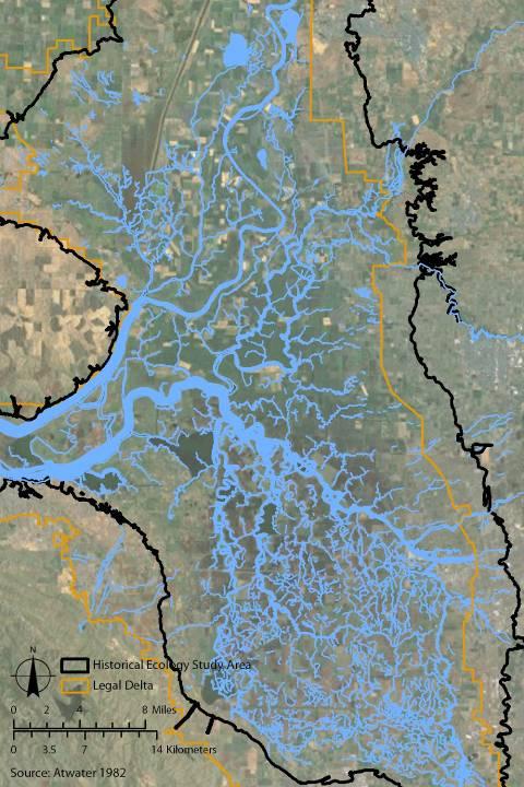
3 STUDY AREA AMERICAN SACRAMENTO COSUMNES MOKELUMNE CALAVERAS SUISUN BAY PUTAH STANISLAUS SAN JOAQUIN CACHE SLOUGH CACHE
4 1800 Archaeology Reports, Tribal Representatives Explorer Journals 1850 Travelogues/Memoirs Diseños, Mexican Land Grant testimony 1900 Maps/Surveys Landscape photos and paintings 1950 Aerial photography Interviews with long-time residents 2000 Scholarly & professional reports & records
5 Initial Concepts Physical gradients of various steepness were expressed over a variety of spatial and temporal scales Tidal channel geometry SALINITY EFFECTS Tidal marshland Ponds and lakes Variable Scales LEVEE EFFECTS ECOTONE COMPLEXITY Interrelationships Time Floodplain basins Riparian Forest Upland Ecotone Dynamic Functions MARSH FORM
6 Fluvial-tidal relationship creates salinity gradients at many scales


7 Distinct sources of tidal and fluvial input Fluvial Tidal
8 Natural levees create separate hydrological subregions
9 Bay Institute 1998
![FLOOD BASINS Natural levee: about ½ mile in width Tule: grows even all over the ground and not in bunches or on tusick [sic] Open water: it gets too deep](/docs-images/93/113021563/images/10-1.jpg "for Tola and then comes the Lake or Pond. - Browning 1851 Courtesy UC Davis, Dept.")
10 FLOOD BASINS Natural levee: about ½ mile in width Tule: grows even all over the ground and not in bunches or on tusick [sic] Open water: it gets too deep for Tola and then comes the Lake or Pond. - Browning 1851 Courtesy UC Davis, Dept. of Special Collections ITEM REMOVED DUE TO COPYRIGHT STATUS Browning 1851
11 Upland marsh edge is a complex and dynamic ecotone

12 CACHE SLOUGH Components of the upland ecotone Complex mosaic Not a smooth edge Estuarine transgression Seasonal wetland Tidal marsh Non-tidal marsh USGS
13 MOKELUMNE ITEM REMOVED DUE TO COPYRIGHT STATUS at the time of low waters there are points and ridges which can be followed in for some distance - W.C. Miller 1859 Fall 1856: I took up from the M into the tule to open spaces which were covered with water where ducks and geese would light. - Samuel Thornton 1859 E. A. Sherman 1859

14 SOUTH DELTA Transition zone between tidal marsh and riverine floodplain USDA 1915
15 SOUTH DELTA Transition zone between tidal marsh and riverine floodplain 1 2 USDA 1915

16 MILE 1 TRANSECT General Land Office survey notes, Ralph W. Norris, October 1851

17 MILE 2 TRANSECT General Land Office survey notes, Ralph W. Norris, October 1851
18 Fluvial-tidal processes affect tidal marsh form (water storage and conveyance)


19 BIG LAKE YOLO BASIN Courtesy UC Davis, Dept. of Special Collections Area: ~500 acres Large open water bodies as freshwater reservoirs USGS


20 SOUTH DELTA Depth: 1 ½ fathoms = 9 ft Area: acres Gibbes 1850 Courtesy UC Davis, Dept. of Special Collections
21 Different expressions of freshwater input In-stream flows: inorganic sediment, short residence time, colder temperatures? Tidal marsh discharge: organic material, longer residence time, capacity for nutrient exchange
22


23 USGS CENTRAL DELTA CACHE SLOUGH


24 TYLER ISLAND Toward channel density

25 DISAPPOINTMENT SLOUGH Toward channel width Disappointment Slough ~100m 10m 10m 13m 8m 8m 12m General Land Office Survey W. F. Benson 1878
26 EMERGING CONCEPTS: LANDSCAPE FORM Physical gradients of various steepness were expressed over a variety of spatial and temporal scales Fluvial-tidal relationship creates salinity gradients at many scales Natural levees create separate hydrological subregions Upland marsh edge is a complex and dynamic ecotone Fluvial-tidal processes affect tidal marsh form (water storage and conveyance)

 Winter flows were held and released through the dry season in freshwater marsh basins,")
27 EMERGING CONCEPTS: LANDSCAPE FUNCTIONS All of the physical gradients translate into complex habitat mosaics A complex channel geometry reflected diverse tidal routing, variable able sediment and nutrient transport, and longer residence time Seasonal flood events affected tidal marsh characteristics (e.g. open water features, sediment, temperature, salinity) Winter flows were held and released through the dry season in freshwater marsh basins, lakes/ponds, groundwater Sacramento River William Jewett 1851 San Joaquin with Mount Diablo in background Thomas Moran 1873
28 THANKS TO FUNDING: Department of Fish and Game, Ecosystem Restoration Program RESEARCHERS: DFG: Carie Battistone, Gena Glasko, Bronwyn Hogan, Amy Lyons, Daniel Rankin, Ciprian Simon, Carl Wilcox, Dave Zezulak SFEI: Ruth Askevold, Erin Beller, Josh Collins, Micha Salomon, Bronwen Stanford, Chuck Striplen OTHER CONTRIBUTORS: Chris Enright Elise Brewster UC Berkeley and The Bancroft Library UC Davis and The Shields Library The Bureau of Land Management The State Lands Commission Bob Webber and Reclamation District 999 Sacramento River Delta Historical Society

29 Thank You NIGHT SCENE ON THE SAN JOAQUIN RIVER MONTE DIABLO IN THE DISTANCE - Hutchings 1862 alison@sfei.org robin@sfei.org
Using the Past to Understand the Present Emerging Lessons for Environmental Planning in the Santa Clara Valley
 Using the Past to Understand the Present -- -- -- Emerging Lessons for Environmental Planning in the Santa Clara Valley Robin Grossinger Director of the Historical Ecology Program San Francisco Estuary
FISH RESTORATION PROGRAM AGREEMENT Implementing Habitat Restoration Requirements Of The Biological Opinions
 FISH RESTORATION PROGRAM AGREEMENT Implementing Habitat Restoration Requirements Of The Biological Opinions Dennis McEwan Department of Water Resources waterways tidal wetlands Whipple et al. 2012: Sacramento-San
Regional Restoration Planning:
 Regional Restoration Planning: A Case Study in Collaborative Restoration Science and Planning Campbell Ingram, Executive Officer NCER August 28, 2018 Co-Equal Responsibilities Act as a primary state agency
A Delta Renewed: A Guide to Science Based Ecological Restoration in the Delta
 A Delta Renewed: A Guide to Science Based Ecological Restoration in the Delta J. Letitia Grenier, San Francisco Estuary Institute, letitia@sfei.org Julie Beagle, San Francisco Estuary Institute, julieb@sfei.org
BAYLANDS SAN FRANCISQUITO CREEK FLOOD CONTROL2.0. June 2016 A PRODUCT OF FLOOD CONTROL 2.0. landscape change metrics analysis
 SAN FRANCISQUITO CREEK BAYLANDS landscape change metrics analysis June 2016 PROJECT DIRECTION Robin Grossinger Scott Dusterhoff PRIMARY AUTHORS Micha Salomon Scott Dusterhoff DESIGN AND LAYOUT Ruth Askevold
Enhancing Biodiversity in an Increasingly Urban World
 Enhancing Biodiversity in an Increasingly Urban World Robin Grossinger, San Francisco Estuary Institute, robin@sfei.org Throughout the 20th century a wave of urbanization has swept across the planet, driving
Ecological Design in the West:
 Ecological Design in the West: Process-based, Performance-driven An AEES Certified Ecological Designer Workshop October 6 8, 2015 University of California, Berkeley The workshop will include a design charrette
Restoring Soil Ecology and Native Plant Communities in an Altered Salt Pond Ecotone
 Restoring Soil Ecology and Native Plant Communities in an Altered Salt Pond Ecotone Dylan Chapple Save The Bay/UC Berkeley dylanchapple@berkeley.edu 10/24/2012 Overview Eden Landing Ecological Reserve
The Napa River Flood Protection Project
 The Napa River Flood Protection Project Creating Flood Protection and Restoring Geomorphic and Biological Processes Jeremy Sarrow, Napa County Flood Control & Water Conservation District June 2, 2014.
NOVATO CREEK BAYLANDS. historical ecology study A PRODUCT OF FLOOD CONTROL FLOOD CONTROL
 NOVATO CREEK BAYLANDS historical ecology study A PRODUCT OF FLOOD CONTROL 2.0 FLOOD CONTROL 2.0 NOVATO CREEK BAYLANDS historical ecology study May 2015 PROJECT DIRECTION Robin Grossinger Scott Dusterhoff
Design Guidelines for the Enhancement and Creation of Estuarine Habitats in the Middle Reaches of the Lower Columbia River
 Design Guidelines for the Enhancement and Creation of Estuarine Habitats in the Middle Reaches of the Lower Columbia River Astoria, May 16, 2012 1 Outline I. Nature of Project/Background II. Approach to
Restoring Water Ecosystems in NYC Parks
 Restoring Water Ecosystems in NYC Parks Hooked on our Waters Con October 19, 2013 - CUNY Graduate Center Marit Larson NYC Parks Landscape and ecosystem focus Watershed Streams Freshwater wetlands Tidal
Baylands Segment J. Bay between the Golden Gate and Segment J. Coyote Point. of For managed ponds. included habitat enhancement.
 Baylands Segment J Crissy Field Alameda Naval Air Station Heron's Head Park COLMA CREEK SFO Millbrae San Mateo BAYLANDS 2009 SAN FRANCISCO AREA san francisco area Western side of central San Francisco
Nature-Based Adaptation Projects Challenges and Opportunities in California Marilyn Latta, Project Manager California State Coastal Conservancy
 Nature-Based Adaptation Projects Challenges and Opportunities in California Marilyn Latta, Project Manager California State Coastal Conservancy Restore America s Estuaries California State Coastal Conservancy
San Joaquin River Restoration Program Mendota Pool Bypass and Reach 2B Improvements Project. Restoration Goal Technical Feedback Group
 San Joaquin River Restoration Program Mendota Pool Bypass and Reach 2B Improvements Project Restoration Goal Technical Feedback Group March 20, 2014 1:30 pm San Luis and Delta-Mendota Water Authority 842
South Bay Science Symposium Summary
 South Bay Science Symposium Summary Date Held: Location: Hosts: Organizers: June 6, 2006 from 9:00am to 5:00pm with a reception from 5:00pm to 7:00pm Dr. Martin Luther King, Jr. Library, San Jose State
Planning for Staten. Habitat Restoration and Green Infrastructure. Island s North Shore
 Habitat Restoration and Green Infrastructure Planning for Staten Island s North Shore Community Board 1 March 1, 2018 NYC Parks Forestry, Horticulture, and Natural Resources Funded by the NYS Department
Section 1 TABLE OF CONTENTS
 Section 1 TABLE OF CONTENTS... [M]ineral fertilizer is essential to feed around half of the world s population, and will be fundamental to ensure global food security through the 21 st century. 2013 U.N.
Prioritizing Tidal Wetlands: A Landscape Approach
 Prioritizing Tidal Wetlands: A Landscape Approach Laura Brophy Director, Estuary Technical Group Institute for Applied Ecology Corvallis, OR College of Earth, Ocean and Atmospheric Sciences, Oregon State
Urban Stormwater Management
 State Regulations and Sustainable Infrastructure April 16, 2011 Urban Stormwater Management Drivers Ecosystem Services LID and Light Imprint New Urbanism Comments MD Stormwater Regulations Larry S. Coffman
1/21/2014. Definitions vary widely Legal vs. functional Not always obvious. Wetlands are legally protected by Clean Water Act (1972)
") What is a Wetland? Freshwater Wetlands of Gulf Coast Plains Definitions vary widely Legal vs. functional Not always obvious What is a Wetland? Wetlands are legally protected by Clean Water Act (1972) Corps
What is a Wetland? Freshwater Wetlands of Gulf Coast Plains Definitions vary widely Legal vs. functional Not always obvious What is a Wetland? Wetlands are legally protected by Clean Water Act (1972) Corps
North Branch of Cypress Creek Ecological Restoration: A Comprehensive Approach to Stream Restoration
 North Branch of Cypress Creek Ecological Restoration: A Comprehensive Approach to Stream Restoration Rocky Powell Clear Creeks Consulting, LLC Keith D. Tate, P.E. BayLand Consultants & Designers, Inc.
Fisher Slough Tidal Marsh Restoration Project Scaling Down the Restoration Planning & Analysis Framework to Evaluate Project Alternatives
 Fisher Slough Tidal Marsh Restoration Project Scaling Down the Restoration Planning & Analysis Framework to Evaluate Project Alternatives Project Sponsor/Partners The Nature Conservancy Dike District #3
Human use of Restored and Naturalized Delta Landscapes
 Human Use of Restored and Naturalized Delta Landscapes Brett Milligan and Alejo Kraus-Polk University of California, Davis August 2016 EXECUTIVE SUMMARY APPROACH & PROJECT DESCRIPTION Current legislation
Green Infrastructure. NYS Department of Environmental Conservation
 Green Infrastructure Green infrastructure is an interconnected network of natural areas and open spaces that sustains ecosystems. Benedict, M.A. and E.T. McMahon. 2006. Green Infrastructure Linking Landscapes
Baylands Segment P. 206 The Baylands and Climate Change: What We Can Do COYOTE CREEK
 Baylands Segment P BAYLANDS coyote 2009 creek area COYOTE Southern CREEK end of San Francisco Bay AREA between Alviso Slough and Albrae Slough Southern end of San Francisco Bay Baylands between Alviso
SBSP Stakeholder Forum TODAY S AGENDA
 TODAY S AGENDA Welcome and Introductions 2008 Progress Report SBSP Project Science Program Shoreline Study Update Cultural Resources: Opportunities and Themes for Interpretation San Jose/Santa Clara Water
Introduction to Ecology and Regulation of Tidal Wetlands in Central California and the San Francisco Bay. August 17, 2005
 Bibliography and Additional Resources for Hydrology, Soils, and Plants NERR Coastal Training Program, Workshop on Tidal Wetlands GENERAL ARTICLES Allen, J. R. L., and K. Pye. 1992. Saltmarshes : Morphodynamics,
Hunts Point Landing, Bronx, New York
 Hunts Point Landing, Bronx, New York Sustainable Shorelines in an Urban Environment John Roebig, PhD. HDR Engineering, Inc. John.Roebig@hdrinc.com Promoting Resilient Shorelines along the Hudson River
Empowering Local Action for Coastal Resilience in Massachusetts. Bruce K. Carlisle MA Office of Coastal Zone Management
 Empowering Local Action for Coastal Resilience in Massachusetts Bruce K. Carlisle MA Office of Coastal Zone Management Context Coastal communities continue to face both chronic and acute storm surge, erosion,
Planning for Staten. Habitat Restoration and Green Infrastructure. Island s North Shore
 Habitat Restoration and Green Infrastructure Planning for Staten Island s North Shore Walker Park December 7, 2017 NYC Parks Forestry, Horticulture, and Natural Resources Funded by the NYS Department of
Restoring Floodplain Capacity and Hyporheic Function in an Urban Setting Thornton Confluence and Kingfisher Projects Mike (Rocky) Hrachovec, P.E.
 Hrachovec, P.E.") Restoring Floodplain Capacity and Hyporheic Function in an Urban Setting Thornton Confluence and Kingfisher Projects Mike (Rocky) Hrachovec, P.E. Project Locations: Historic Map of Thornton Creek orth
Restoring Floodplain Capacity and Hyporheic Function in an Urban Setting Thornton Confluence and Kingfisher Projects Mike (Rocky) Hrachovec, P.E. Project Locations: Historic Map of Thornton Creek orth
Landscape Conservation Design April, 2014
 Designing Sustainable Landscapes in the Northeast A project of the North Atlantic Landscape Conservation Cooperative & Northeast Climate Science Center Landscape Conservation Design April, 2014 Conceptual
ROLE OF LANDSCAPE CONSERVATION COOPERATIVES IN EVERGLADES RESTORATION
 ROLE OF LANDSCAPE CONSERVATION COOPERATIVES IN EVERGLADES RESTORATION GEER April 2017 Steve Traxler 1, Todd Hopkins 1, Beth Stys 2 1 US Fish and Wildlife Service 2 Florida Fish & Wildlife Conservation
Pontchartrain Coastal Lines of Defense Program Figure 1 Figure 2 Figure 1
 Pontchartrain Coastal Lines of Defense Program Coastal Sustainability Program February 2006 The Pontchartrain Coastal Lines of Defense Program consists of ten priority project areas within the Pontchartrain
BASS PONDS, MARSH, & WETLAND HABITAT RESTORATION PROJECT
 FACT SHEET BASS PONDS, MARSH, & WETLAND HABITAT RESTORATION PROJECT MINNESOTA VALLEY NATIONAL WILDLIFE REFUGE, MINNESOTA ENVIRONMENTAL MANAGEMENT PROGRAM LOCATION Three areas located on the Minnesota Valley
Pond to Plate (digital collage/painting using aerial imagery and drone photography)
") Bios Forbes Lipschitz is an Assistant Professor of Landscape Architecture at the Knowlton School at the Ohio State University, where she teaches studio and seminar courses in landscape planning and representation.
Bios Forbes Lipschitz is an Assistant Professor of Landscape Architecture at the Knowlton School at the Ohio State University, where she teaches studio and seminar courses in landscape planning and representation.
7.0 SOCIAL, ECONOMIC, AND ENVIRONMENTAL ISSUES
 7.0 SOCIAL, ECONOMIC, AND ENVIRONMENTAL ISSUES The following list of social, economic, and environmental issues have been identified based on a preliminary inventory of resources in the project area, an
Kootenai River Habitat Restoration Program June 18, 2018 Kootenai Valley Resource Initiative Update
 Kootenai River Habitat Restoration Program June 18, 2018 Kootenai Valley Resource Initiative Update Kootenai River Habitat Restoration Program Multi-year habitat restoration program Restoration treatments
Draft Rhode Island Stormwater Design and Installation Standards Manual
 Draft Rhode Island Stormwater Design and Installation Standards Manual Summary The May 2009 Public Review Draft version of the RI Stormwater Design and Installation Standards Manual consists of approximately
Recent Tidal Creek Restoration Efforts in Tampa Bay
 Recent Tidal Creek Restoration Efforts in Tampa Bay Ed Sherwood Tampa Bay Estuary Program Co-Authors: Brandt Henningsen, SWFWMD, SWIM Overview Tampa Bay Watershed & Tidal Creek Overview Habitat Restoration
WATERSHED. Greg Goodrum Mitchell Donovan Aubie Douglas Christina Morrisett Jenna Keeton
 WATERSHED SCIENCE MEET OUR GRADUATE STUDENT MENTORS Greg Goodrum Mitchell Donovan Aubie Douglas Christina Morrisett Jenna Keeton GREG GOODRUM Master's Student Goodrum.greg@gmail.com Hi! I m Greg, and I
AREA-WIDE PEDESTRIAN AND BICYCLE CIRCULATION
 OUSD LANEY CHILD CARE CENTER ART BUILDING LANEY COLLEGE BALL FIELDS PCCD OFFICES PERALTA PARK AQUATIC CENTER & ESTUARY PARK EDOFF MEMORIAL BANDSTAND SNOW PARK COURT HOUSE OAKLAND MUSEUM OAK ST AREA-WIDE
Conserving Ca[ifomiaJs Wi[tf[ife Si~e 1870
 State of California - The Resources Aqency DEPARTMENT OF FISH AND GAME huo:/ /www.dfg.ca.gov POST OFFICE BOX 47 YOUNTVillE, CALIFORNIA 94599 (707) 944-5500 ARNOLD SCHWARZENEGGER. Governor October 5,2007
[FWS R8 R 2015 N087; FXRS282108E8PD0 156 F ] South Bay Salt Pond Restoration Project, Phase 2; Don Edwards National Wildlife
![[FWS R8 R 2015 N087; FXRS282108E8PD0 156 F ] South Bay Salt Pond Restoration Project, Phase 2; Don Edwards National Wildlife](/thumbs/84/90602803.jpg "[FWS R8 R 2015 N087; FXRS282108E8PD0 156 F ] South Bay Salt Pond Restoration Project, Phase 2; Don Edwards National Wildlife") Surname Billing Code: 4310 55 Deputy RD ARD Refuges DEPARTMENT OF THE INTERIOR Fish and Wildlife Service Solicitor Refuge Supervisor Asst. Refuge Supervisor Ch. Natural Resources Project Leader [FWS R8
Surname Billing Code: 4310 55 Deputy RD ARD Refuges DEPARTMENT OF THE INTERIOR Fish and Wildlife Service Solicitor Refuge Supervisor Asst. Refuge Supervisor Ch. Natural Resources Project Leader [FWS R8
Chapter 3 Site Planning and Low Impact Development
 CHAPTER 3 Site Planning and Low Impact Development Chapter 3 Site Planning and Low Impact Development 3.0 Introduction The City of Charleston requires that major residential, large commercial (>1 acre),
April 11, 2016 Park Board Chair and Commissioners General Manager Vancouver Board of Parks and Recreation New Brighton Salt Marsh - Preferred Concept
 TO: FROM: SUBJECT: April 11, 2016 Park Board Chair and Commissioners General Manager Vancouver Board of Parks and Recreation New Brighton Salt Marsh - Preferred Concept RECOMMENDATION A. THAT the Vancouver
Biodiversity Conservation
 Biodiversity Conservation and Site Plan Review Biodiversity conservation principles Threats to biodiversity Location of development Reviewing site plans Lunch Reviewing site plans (continued) LEED and
CAMPUS HISTORY AND STEWARDSHIP
 CHAPTER TWO CAMPUS HISTORY AND STEWARDSHIP The stewardship of the UC Davis campus history and the rich collection of natural and cultural resources is a fundamental task for the LRDP. This chapter is organized
Antioch Habitat Conservation Plan/Natural Community Conservation Plan
 Antioch Habitat Conservation Plan/Natural Community Conservation Plan Science Advisor Workshop February 8, 2018 Kathryn Gaffney Project Manager Matt Ricketts Lead Biologist 1 PRESENTATION OUTLINE Background
Natural Resource Adaptation Action Area Addressing Sea Level Rise in Estuarine Ecosystems TO: TOWN OF YANKEETOWN MAY
 Natural Resource Adaptation Action Area Addressing Sea Level Rise in Estuarine Ecosystems TO: TOWN OF YANKEETOWN MAY 6 2013 University of Florida Conservation Clinic Vivek Babbar, Student Associate, J.D.
OYSTER LAKE RESTORATION PROJECT
 Photo courtesy of Scott Jackson, PhotosFlorida. com Sarah Kalinoski, Choctawhatchee Basin Alliance OYSTER LAKE RESTORATION PROJECT OVERVIEW What? Where? Who? COASTAL DUNE LAKES Walton County, Florida Found
Florida Forever Conservation Needs Assessment Overview Maps
 Florida Forever Conservation Needs Assessment Overview Maps Prepared by Florida Natural Areas Inventory, The maps in this document are derived from the Florida Forever Conservation Needs Assessment, an
Improving Communities Through the Arroyo Seco Sustainability Campaign and Watershed Assessment
 Improving Communities Through the Arroyo Seco Sustainability Campaign and Watershed Assessment Arroyo Seco Headwaters in the San Gabriel Mountains Major tributary to the Los Angeles River 44 square mile
TOWN OF BETHLEHEM OPEN SPACE CONSERVATION PLAN PUBLIC MEETING: OCTOBER 12, 2017
 TOWN OF BETHLEHEM OPEN SPACE CONSERVATION PLAN PUBLIC MEETING: OCTOBER 12, 2017 Welcome and Agenda 6:00 6:45: Open House, Part One 6:45 7:15: Presentation and Questions 7:15 8:00: Open House, Part Two
Conservation by Design: Promoting Resilient Coastal Wetlands & Communities. GreatLakesLCC.org
 Conservation by Design: Promoting Resilient Coastal Wetlands & Communities Brent Schleck The Baldwin Group - NOAA Office for Coastal Management ASFPM 6/22/16 GreatLakesLCC.org Overview 2 Great Lakes coastal
Coastal Planning in Texas. Tony Williams Senior Director of Planning Coastal Resources Division Texas General Land Office
 Coastal Planning in Texas Tony Williams Senior Director of Planning Coastal Resources Division Texas General Land Office e The Texas General Land Office (GLO) and the Texas Coast Since 1836: Manager of
The Flow. Green Infrastructure Taking Root in Cities 3/23/2015. Green Infrastructure Evolution City Plans/Projects Measureable and Holistic Benefits
 Green Infrastructure Taking Root in Cities Robert Hopper, P.E. CDM Smith The Flow Green Infrastructure Evolution City Plans/Projects Measureable and Holistic Benefits 2 1 Parts, Systems, Whole The first
Landscape Structure and Geophysical Parameters that Control the Hydrology of Venal Pools
 Landscape Structure and Geophysical Parameters that Control the Hydrology of Venal Pools Presentation by Niall McCarten, Institute for Ecohydrology Research and Dept. of Land, Air, and Water Resources,
Information for File # MMJ; Methodist Hospital Flood Storage Mitigation and Wetland Enhancement Project
 Information for File # 2016-01223-MMJ; Methodist Hospital Flood Storage Mitigation and Wetland Enhancement Project Applicant: Park Nicollet, Attn: Robert Riesselman Corps Contact: Melissa Jenny Address:
Gather information from online resources covering the following topics:
 Assignment #1: Regional Analysis Project Site Location: Greater Boston Area What comprises a region? The many elements within a region comprise the region as a whole. Natural as well as manmade environmental
Presentation to Parks and Open Space Advisory. Committee September 22, 2016
 Flood Planning & Preliminary Design Services for South St. Vrain Creek Restoration at Hall Ranch Presentation to Parks and Open Space Advisory Prepared for: Boulder County, Colorado Committee September
COLLIER BOULEVARD (CR 951) CORRIDOR
 CORRIDOR") Project(s) Goals Improve Traffic Circulation, Capacity & Safety Focus on Safety During Design & Construction Address Public Concerns Design an Aesthetically Pleasing Project Limit Environmental Impacts
Project(s) Goals Improve Traffic Circulation, Capacity & Safety Focus on Safety During Design & Construction Address Public Concerns Design an Aesthetically Pleasing Project Limit Environmental Impacts
Ecosystem Restoration Business Line Budgeting A Systems Approach
 Ecosystem Restoration Business Line Budgeting A Systems Approach Laura Orr (NWS), Shawn Phillips (MVM), Greg Steele (NAO) Introduction Chesapeake Bay Bridge Mouth of Mississippi River Bonneville Dam Fish
MITIGATION MANAGEMENT AND MONITORING PLAN BAYFRONT PARK WETLAND RESTORATION MILL VALLEY, CA
 MITIGATION MANAGEMENT AND MONITORING PLAN BAYFRONT PARK WETLAND RESTORATION MILL VALLEY, CA PREPARED FOR: THE CITY OF MILL VALLEY PARKS AND RECREATION DEPARTMENT 180 CAMINO ALTO AVENUE MILL VALLEY, CA
STEWARDSHIP OF LONG ISLAND SOUND S ECOLOGICAL AND RECREATIONAL RESOURCES
 STEWARDSHIP OF LONG ISLAND SOUND S ECOLOGICAL AND RECREATIONAL RESOURCES Robin Kriesberg, Save the Sound, Inc. Thomas Halavik, US Fish and Wildlife Service Coastal Program An Initiative to Identify, Protect
Proposed Ranked List of Projects for Capital Budget Funding
 Proposed Ranked List of Projects for 2015-17 Capital Budget Funding Ecology Publication #: 14-06-033 October 2014 Ecology Publication #: 14-06-033 October 2014 Focus on Proposed Projects for FY 15-17 Floodplains
Welcome! Rain Barrel Workshop. April 4th, 2011 Groveton Elementary School Alexandria, Virginia
 Welcome! Rain Barrel Workshop April 4th, 2011 Groveton Elementary School Alexandria, Virginia Regional Rain Barrel Program Partners Reston Association Why Rain Barrels? Part of a bigger picture: Water
City of Surrey Ecosystem Management Study. Integration of ecological processes with land use
 City of Surrey Ecosystem Management Study Integration of ecological processes with land use Natural areas in Surrey are changing as the City grows and evolves. Many important natural areas remain or may
Ravenswood Working Group Mee4ng, February 10, 2011, 1-4 p.m.
 Ravenswood Working Group Mee4ng, February 10, 2011, 1-4 p.m. Today s Agenda Introduc)ons & Welcome Track Our Progress Project- wide Track Our Progress: Phase 1 at Ravenswood South San Francisco Bay Shoreline
INTRODUCTION CHAPTER 1 MONICA PETERS CONTENTS INTRODUCTION. 1 USING THE HANDBOOK 1.1 Handbook structure Handbook sections
 CHAPTER 1 INTRODUCTION MONICA PETERS CONTENTS INTRODUCTION 1 USING THE HANDBOOK 1.1 Handbook structure 1.1.2 Handbook sections 2 CASE STUDIES 2.1 Case study locations CHAPTER ONE INTRODUCTION 1 INTRODUCTION
Surrey Ecosystem Management Study
 Surrey Ecosystem Management Study Green Infrastructure Network Opportunities Public Open House & Information Session June 24 th, 2010 EMS Process Ecological Inventory Ecological Assessment Management Policy
Reconnect, Rewild & Restore
 Trophic Cascades, Habitat Fragmentation and Climate Change, the Need to Reconnect, Rewild and Restore Terrestrial Landscapes Keith Bowers, Biohabitats, Inc. CEER 2014 UN, IUCN, CBD, Ramsar, World Bank
Bristol Marsh Heritage Conservancy
 Bristol Marsh Heritage Conservancy The Pennsylvania Environmental Council (PEC) protects and restores the natural and built environments through innovation, collaboration, education and advocacy. PEC believes
Building Ecological Solutions to Coastal Community Hazards: Guidance and NJ Coastal Community Assistance
 Building Ecological Solutions to Coastal Community Hazards: Guidance and NJ Coastal Community Assistance Stacy Small-Lorenz National Wildlife Federation Restore America s Estuaries Summit New Orleans,
ME DOT Route 3. File No.: City and State: Bar Harbor, ME
 ME DOT Route 3 File No.: 199600361 City and State: Bar Harbor, ME General Impacts: 0.28 acre tidal emergent 0.77 acre non-tidal forested 0.15 acre non-tidal emergent 0.51 acre non-tidal scrub-shrub Functions
City of Surrey Ecosystem Management Study. Integration of ecological processes with land use
 City of Surrey Ecosystem Management Study Integration of ecological processes with land use Natural areas in Surrey are changing as the City grows and evolves. Many important natural areas remain or may
EACCS Goal: provide guidelines for mitigation practices and overall conservation in east Alameda County
 EAST ALAMEDA COUNTY CONSERVATION STRATEGY: A BLUEPRINT FOR ACTION Community Meeting June 11, 2009 Agenda Welcome and Introductions Project Update o Introduction o Progress to Date o Next Steps Perspectives
The Benefits and Challenges Associated with Green Infrastructure Practices
 The Benefits and Challenges Associated with Green Infrastructure Practices Thomas M. Evans ASLA, LEED AP Regional Green Infrastructure Design Services Director OWEA Technical Conference, June 20, 2013
Conservation in South Jersey Being Creative with Restoration
 Conservation in South Jersey Being Creative with Restoration Stewardship on a Shoestring: Public Land Management in Fiscally Constrained Times November, 30, 2011 Conservation and Restoration for Open Space
Community LID Workgroup Issue Paper #6
 Community LID Workgroup Issue Paper #6 Topic: Hard and Impervious Surface Coverage Limits Objective: Minimize the amount of hard and impervious surfaces in developments to allow more stormwater to infiltrate
Saltmarsh Conference. 8 October in the Suffolk Coast & Heaths Area of Outstanding Natural Beauty
 Saltmarsh Conference 8 October 2015 in the Suffolk Coast & Heaths Area of Outstanding Natural Beauty Conference organised by Haidee Stephens, Suffolk Estuaries Officer Suffolk Coast & Heaths AONB t: 01394
Green Inspirations for Landscapes
 Master Gardener Conference 2010 Green Inspirations for Landscapes Carl I. Evensen Associate Dean/Director Cooperative Extension OUTLINE: Hawaiian Hydrology Urban Runoff and Pollution Green Landscaping
Using Soil Attributes for HGM Wetland Classification
 Using Soil Attributes for HGM Wetland Classification Richard Weber Wetland Hydraulic Engineer Wetland Team (Ret.) CNTSC, Fort Worth, TX Slide 1 Data Sources: Web Soil Survey County Scale Smaller than Reference
ST. MARY S SOIL CONSERVATION DISTRICT (SMSCD) AND DPW&T CONCEPT EROSION AND SEDIMENT CONTROL AND STORMWATER MANAGEMENT GUIDELINES AND CHECKLIST
 AND DPW&T CONCEPT EROSION AND SEDIMENT CONTROL AND STORMWATER MANAGEMENT GUIDELINES AND CHECKLIST") St. Mary s Soil Conservation District 26737 Radio Station Way, Suite B Leonardtown, MD 20650 Phone: 301-475-8402 ext. 3 Fax: 301-475-8391 www.stmarysscd.com St. Mary s County Government Department of Public
St. Mary s Soil Conservation District 26737 Radio Station Way, Suite B Leonardtown, MD 20650 Phone: 301-475-8402 ext. 3 Fax: 301-475-8391 www.stmarysscd.com St. Mary s County Government Department of Public
Los Angeles River-Arroyo Seco Confluence Restoration Vision Plan. Professor Meredith McKenzie, JD Urban & Regional Planning Dept Cal Poly Pomona
 Los Angeles River-Arroyo Seco Confluence Restoration Vision Plan Professor Meredith McKenzie, JD Urban & Regional Planning Dept Cal Poly Pomona The Los Angeles River Watershed Arroyo Seco Watershed Map
Terra Nova Rural Park Plan
 Terra Nova Rural Park Plan Part 1 Getting to know the land The Surrounding Area North Side Airport, River, Trail East Side - Residential West Side- Sturgeon Banks, West Dyke Trail South Side:Terra Nova
CONSERVATION ELEMENT GOALS, OBJECTIVES, AND POLICIES
 CONSERVATION ELEMENT GOALS, OBJECTIVES, AND POLICIES Goal 4 To conserve, manage, appropriately use and protect the natural resources of the City ensuring continued resource availability and environmental
NORTH BAY RECREATION AND NATURAL AREA
 HUDSON NORTH BAY RECREATION AND NATURAL AREA City of Hudson, New York Prepared by the Columbia Land Conservancy North Bay: from forgotten waterfront to dynamic public park The proposal for the North Bay
Commercial Launch Site Addendum to Wetland Mitigation Plan. Revision 2. April 25, SpaceX Proprietary
 Commercial Launch Site Addendum to Wetland Mitigation Plan Revision 2 April 25, 2017 SpaceX Proprietary Contents 1.0 Project Information... 1 1.1 Background... 1 2.0 Compensatory Mitigation... 2 2.1 Goals
RECOMMENDATIONS. Design Recommendations
 RECOMMENDATIONS While the San Diego River Park will serve to unify the river as a whole, each reach of the river park maintains distinct resources and character. Recommendations for each reach have been
Karen A. Duhring Marine Advisory Scientist Center for Coastal Resources Management Virginia Institute of Marine Science College of William & Mary
 Karen A. Duhring Marine Advisory Scientist Center for Coastal Resources Management Virginia Institute of Marine Science College of William & Mary March 20, 2009 Low-Impact Shoreline Stabilization Cumulative
Subject: Sea Level Rise Constraints and Opportunities for India Basin
 Memorandum To: Monica Melkesian, Build Inc Cc: From: Leslie Lazarotti lazarotti@wra-cacom Ext 1300 Subject: Sea Level Rise Constraints and Opportunities for Date: July 8, 2015 The impetus for this study
Riparian Ecology and Plant Identification Ventura River and Casitas Springs Community Center Nov 7-8, 2007
 The CNPS Plant Science Training Program is proud to present a two-day Riparian workshop, at the, Casitas Springs (between Ventura and Ojai) Target audience: Professional and student botanists, biologists,
RIPARIAN HABITAT RESTORATION. Helen Swagerty Senior Restoration Biologist/Project Manager
 RIPARIAN HABITAT RESTORATION Helen Swagerty Senior Restoration Biologist/Project Manager RIVER PARTNERS: OUR HISTORY Synergy between the fields of ecological restoration and agriculture 3 Offices: Chico,
Innovative Land Use Techniques
 Innovative Land Use Techniques A Handbook for Sustainable Development Eric Williams, Assistant Administrator, NHDES Carolyn Russell, Principal Planner, NHDES Cliff Sinnott, Executive Director, RPC Jill
Update on the Bayfront Canal Bypass Project. Recommendation This an informational item only. No City Council action is required at this time.
 AGENDA ITEM H-7 continued from 4/18 Public Works STAFF REPORT City Council Meeting Date: 4/18/2017 Staff Report Number: 17-081-CC Informational Item: Update on the Bayfront Canal Bypass Project Recommendation
Old Mill Community Association Bioretention Facility
 Project Overview This project will install a bioretention facility in a community recreation area owned by the Old Mill Community Association, Inc. Drainage from the area is currently unmanaged and has
The Moors at Arne Project, Managing Coastal Change
 General Questions What are we doing? The Environment Agency, RSPB and Natural England are working together to adapt approximately 150ha of The Moors at Arne into a diverse wetland habitat. With the sea
Wetland Types. Grade Level: Basic. Duration: 30 minutes. Setting: Classroom
 Wetland Types Adapted from: An original Creek Connections activity created by Cassandra Hamilton. Creek Connections, Box E, Allegheny College, Meadville, PA 16335 http://creekconnections.allegheny.edu