Using Soil Attributes for HGM Wetland Classification
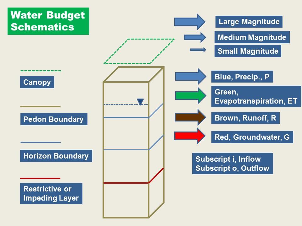
|
|
|
- Gavin Heath
- 6 years ago
- Views:
Transcription

1 Using Soil Attributes for HGM Wetland Classification Richard Weber Wetland Hydraulic Engineer Wetland Team (Ret.) CNTSC, Fort Worth, TX Slide 1
2 Data Sources: Web Soil Survey County Scale Smaller than Reference Domain Pre-built Interpretations Geospatial Data Gateway Statewide Data Raster and Vector Larger than Reference Domain User Selected Interpretations MLRA Attribute Selection crunches an entire State s data Slide 2
3 Major Land Resource Areas GIS Layer Geospatial Data Gateway Slide 3

4 The Reference Domain The area within which a defined Subclass Exists Major Land Resource Area is a Good Default MLRA Subdivisions may Exist for Further Refinement Slide 4

5 Map Unit Polygons Also Occupy Landscape Positons in the Watershed SSURGO Geomorphic Descriptions are Useful, i.e.: Upland Drainageway Terrace Floodplain Depression Many, many others used Slide 5
6 Hydrologic Soil Group - HSG Developed ONLY for use to determine Runoff Curve Number (RCN) NRCS RCN Method HSG A, B, C, or D A Low runoff (think sponge) Low Runoff infers high recharge D High Runoff (think Duck s back) High Runoff infers low recharge Important in assessing wetland watershed Q: Is a watershed of HSG A or B soils likely to support Discharge Wetlands? HSG is in both WSS and SSURGO data Slide 6
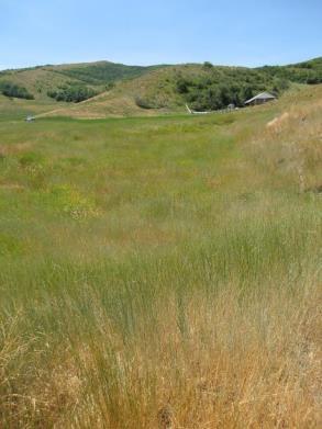
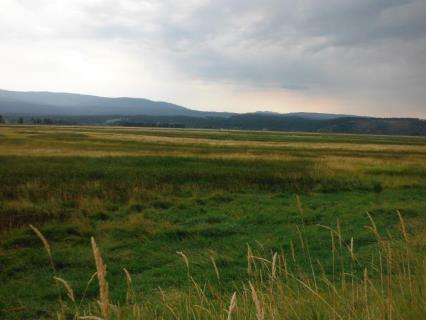
 Willamette Valley, Oregon Wet Prairie (Tufted Hairgrass Provides Microtopography)")
7 Slope Class Soil Map Units have Slope Class Data Only Available in SSURGO Directly Applicable to Mineral Flats (0-2%) Willamette Valley, Oregon Wet Prairie (Tufted Hairgrass Provides Microtopography) Slide 7
8 Water Features WSS Provides Flooding, Ponding, and Groundwater Frequency and Duration by Month Quickly SSURGO requires user to access multiple tables, BUT more detail is available Flooding Lotic RIVERINE AND SLOPE Classes Ponding Lentic DEPRESSION, and Depressions in RIVERINE Slide 8
9 Taxonomy: Use With Care: Orders: Histosols ORGANIC FLATS and discharge sites like SLOPE and Discharge DEPRESSION Require near continuous saturation to form and maintain Entisols Young Soils like floodplains Suborders: Aquic (wet), Fluvic (water formed) Great Groups Includes Minerology Calcic indicates discharge Sub-Groups Available in both WSS and SSURGO Lack of evidence in the taxononomy does NOT mean absence of the attribute Slide 9 Presence of evidence in the name is more useful
10 Endo saturated and Epi saturated Great Groups: Use With Care: Endosaturated soils indicate Discharge Episaturated soils indicate Recharge Definition is depth of saturation down to 200 cm Not meant to be a hydrodynamic interp. Typical Episaturated wetlands: Episaturated RIVERINE, Recharge DEPRESSION, MINERAL FLAT Typical Endosaturated wetlands: SLOPE, Discharge DEPRESSION, Endosaturated RIVERINE Slide 10
11 Minerals and Great Groups Groundwater Dissolved Minerals At point of Discharge, ET leaves mineral concentrations behind Best Example is Calcium (calcic), ex: calciaquolls Horizonation - Bk Slide 11
12 Saturated Hydraulic Conductivity (Ksat) Function of: Texture Structure Bulk Density Others Increase in Ksat with Depth Indicates Vertical Downward Movement (Recharge) Recharge Wetlands MINERAL FLATS, Recharge DEPRESSIONS Episaturated RIVERINE Ex. Bt horizons Slide 12
13 Other Useful Soil Attributes from SSURGO: Geomorphic Description Drainage Class Slope Class Taxonomy Horizons Water Features Flooding Freq. and Dur. Ponding Freq. and Dur. Groundwater Depths Digital Elevation Data Can be used also to Aggregate and Dis-Aggregate Map Units Useful Database Tables: Component Map Unit Map Unit Aggregated Attributes (muaggat) Beyond our Scope Today Slide 13

14 Selection by Attributes SSURGO Vector Polygons Site or HUC-12 Scale Heads-up Mapping Red Calcareous Wet Prairie MINERAL FLAT Green Calcareous Marsh DEPRESSION Slide 14

15 HUC -12 Scale Large Enough to Display all HGM subclasses Small Enough to Visualize Floodplain Landscape Slide 15

16 RIVERINE ATTRIBUTES Geomorphic Descrition floodplain term Water Features Flooding means Lotic inundation Flood Frequency higher than Rarely RIVERINE Water Features can include Flooding, Ponding, and Groundwater all 3 Slide 16

17 RIVERINE Soil System Multiple HGM Sub-Classes Look for more geomorphic description detail Ex. Backswamps, Natural Levees, Oxbows on Floodplains Look for more Water Features. Ex. Ponding means it s a backswamp Slide 17

18 Problem! Stream Functions Vary with Scale 2 nd Order Kennebec 5 th Order Kennebec Map Unit Dis-Aggregation Slide 18


 No decrease in")
19 SLOPE Headwater Reaches Look for: High Water Table Histosols or Histic Epipedon Horizon Non-Floodplain geomorph (i.e. Upland Drainageways) No decrease in Ksat with Depth Slide 19

20 Landscape Functional Break: SLOPE to RIVERINE HGM Class Blue Ackmore Colo Complex, Endoaqolls, Upland Drainageways, WTD < 12 SLOPE Class Green Floodplains Slide 20


21 SLOPE Wetlands Watershed Reaches Above Floodplains Idaho Headwater Fen Kansas Headwater New York Headwater Fen Attributes: Taxonomy endosaturated Great Group Taxonony Histosol or Histic Geomorphic Description Ex. upland drainageways Water Features WTD < 12, most months Slide 21


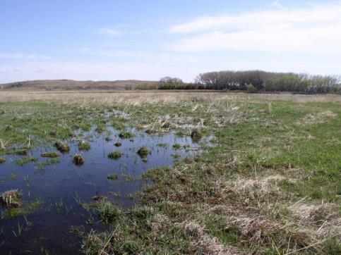
22 DEPRESSION CLASS Nebraska Rainwater Basin Recharge DEPRESSION Wyoming Recharge DEPRESSION, Gillette South Carolina Carolina Bay Discharge DEPRESSION South Dakota Prairie Pothole Recharge DEPRESSION Slide 22


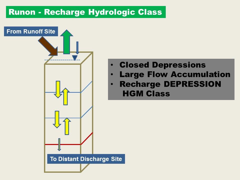
23 DEPRESSION - Recharge Horizonation Perching Layer. Look for Bt horizon Drastic decrease in Ksat with depth Slide 23
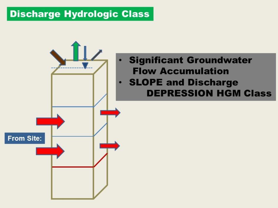
24 DEPRESSION - Discharge High Infiltration Uplands Support Strong Discharge Wetlands No perching layer Taxonomy Ex. Calcic subgroup Taxonomy Histosols or Histic Recharge Go > GI Discharge Gi > Go Flow Through Gi = Go Slide 24
 0-2% Slope Class Poorly Drained Also Decrease in Ksat with Depth Water Features no ponding, no flooding, only WTD < 12 Yellow DEPRESSION")
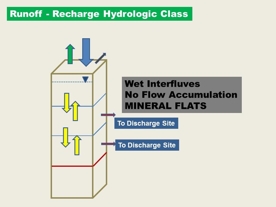
25 MINERAL FLAT and DEPRESSION Brown MINERAL FLATS Interfluves (geomorphic desc.) 0-2% Slope Class Poorly Drained Also Decrease in Ksat with Depth Water Features no ponding, no flooding, only WTD < 12 Yellow DEPRESSION Depressions (geomorphic desc.) Ponding Frequency and Duration No Flooding Slide 25

26 Defining Landscape Ecological Function with the use of Hydrodynamic Vectors Slide 26
27 Hydrology Informed Wetland Classification Wetland sub-classes: Have a System Boundary Same Water Budget within the boundary Same Ecological Functions within the boundary Same Plant Community Same Maintenance Processes Same Response to Disturbance Same Management Prescriptions Same Soil Attributes Slide 27
28 Existing Landscape Classification Concepts Ecological Site Descriptions Starts with Plant Community States in Transition Driven by Disturbance Hydrogeomorphic (HGM) Landscape Classification Landscape and Hydrology Based Originally Developed for Wetland Functional Assessment Cooperative Soil Survey Mapping Driven by Landscape and Hydrologic Factors Slide 28
29 Tool for Wetland Definition Using Soils and Hydrology - Needs Simple Qualitative to Quantitative Translates to Spatial Mapping and Modeling Provides Visual Representation Uses Existing Soils Database Applies to all landscapes One-dimensional to three-dimensional Slide 29
30 Slide 30
")


31 Uplands (Interfluves) Indiana Flatwoods Nebraska Sandhills Prairie Pothole Region High Plains Colorado
32 Slide 32

33 Wet Interfluves- Mineral Flats < 1 acre Drainage Area WT < 12 Feeds Discharge Sites Delmarva Peninsula Slide 33
34 Slide 34

35 Moist Upland Sites Slide 35

36 Headwaters Utah Iowa Des Moines Lobe Idaho Panhandle Nebraska Sandhills

37 Losing Watershed Reaches NOT A WETLAND Slide 37

38 Wet Headwaters Boundary County, ID Slide 38

39 Groundwater Supply is increased with HSG A, B Soils Slide 39
40 Closed Recharge Depressions Prairie Potholes Slide 40
41 Slide 41

42 Closed Recharge Depressions and Wet Headwaters Slide 42
43 Slide 43
44 Landscape Definitions Vector Parameters Magnitude and Direction Runoff Runon Recharge Discharge Apply to Landforms: Watershed Elements Interfluves Headwaters Stream Corridors Slide 44

45 Jasper County, IA Brown Recharge/Discharge Mineral Flat Green Runon/Discharge Depression Blue Runon/Recharge/Discharge Headwater Yellow Runon/Runoff/Discharge Floodplain Slide 45

46 Questions? Wet Headwater Kansas Flint Hills photo: Jon Fripp

47 Thanks! Questions? Wetland HydrologyTechnical Note: Technical Note No. 3 - Soil Hydrodynamic Interpretations for Wetlands nrcs/main/national/water/wetlands/restore/ NRCS is an Equal Opportunity Slide 47 Employer and Provider
Using Soil Attributes for HGM Wetland Classification
 Using Soil Attributes for HGM Wetland Classification Richard Weber Wetland Hydraulic Engineer Wetland Team CNTSC, Fort Worth, TX Slide 1 Hydrogeomorphic (HGM) Landscape Classes Originally for Development
Hydric Soils - Overview
 Hydric Soils - Overview The Hydric Soils section presents the most current information about hydric soils. It updates information that was previously published in "Hydric Soils of the United States" and
 108 40' 29'' W Soil Map Mesa County Area, Colorado 108 36' 55'' W 39 10' 11'' N 39 6' 31'' N 4331700 4332500 4333300 4334100 4334900 4335700 4336500 4337300 4338100 701100 701900 702700 703500 704300 705100
Custom Soil Resource Report for Van Buren County, Iowa
 United States Department of Agriculture Natural Resources Conservation Service A product of the National Cooperative Soil Survey, a joint effort of the United States Department of Agriculture and other
SOIL DATA: Avondale. in Allen, TX. This information was taken from NRCS web soil survey of Collin County, Texas.
 SOIL DATA: Avondale in Allen, TX This information was taken from NRCS web soil survey of Collin County, Texas. United States Department of Agriculture Soil Conservation Service in cooperation with Texas
Florida Forever Conservation Needs Assessment Overview Maps
 Florida Forever Conservation Needs Assessment Overview Maps Prepared by Florida Natural Areas Inventory, The maps in this document are derived from the Florida Forever Conservation Needs Assessment, an
2014 Iowa FFA Soil Judging CDE Exam
 2014 Iowa FFA Soil Judging CDE Exam 1. Landscape position is one aspect of evaluating the surface features of a certain tract of land. Identifying the correct landscape position will indicate: a. If the
BLACK/HARMONY/FAREWELL CREEK WATERSHED EXISTING CONDITIONS REPORT CHAPTER 5 IMPERVIOUS SURFACES
 BLACK/HARMONY/FAREWELL CREEK WATERSHED EXISTING CONDITIONS REPORT CHAPTER 5 IMPERVIOUS SURFACES Draft November 2009 TABLE OF CONTENTS 1.0 INTRODUCTION... 3 2.0 STUDY AREA AND SCOPE... 4 3.0 METHODOLOGY...
Custom Soil Resource Report Soil Map
 77 11' 22'' W Custom Soil Resource Report Soil Map 77 9' 43'' W 36 48' 13'' N 304700 304900 305100 305300 305500 305700 305900 306100 306300 306500 306700 306900 307100 36 48' 13'' N 36 47' 21'' N 4073800
Soil Classification: Outline
 Soil Classification: Outline Introduction Soil moisture regimes Soil temperature regimes The Soil Taxonomy Diagnostic horizons soil orders Why Classify? Organize knowledge in an attempt to find order in
URBAN SOILS & SEATTLE EXAMPLES
 Class Results - Mystery Soil #1 14 12 10 8 6 4 2 0 Sandy Clay Loam Sandy Loam Silty Loam Class Results - Mystery Soil #2 6 5 4 3 2 1 0 Silty Clay Clay Loam Sandy Sandy Silty Sandy Silty Loamy Loam Clay
If you are not able to turn in your notebook see me or Dan ASAP
 Notebook Collection Collecting hard copies now OR Electronic versions using Catalyst drop box Due by 5:30 pm today Use website for link If you are not able to turn in your notebook see me or Dan ASAP URBAN
Soil Interpretations Erosion and Sedimentation Control Planning and Design Workshop
 Soil Interpretations Erosion and Sedimentation Control Planning and Design Workshop Presented by Richard Brooks Presentation prepared by Kristin May Resource Soil Scientists USDA-Natural Resources Conservation
September 20, 2016 Soils Investigation for Agricultural Designation Windemere Place, Missoula County, Montana
 September 20, 201 Soils Investigation for Agricultural Designation Windemere Place, Missoula County, Montana The purpose of this report is to compare on-site soils of the proposed subdivision with the
2017 Iowa FFA Soil Judging CDE Exam
 2017 Iowa FFA Soil Judging CDE Exam 1. Landscape positions vary in soil composition and makeup. What landscape position would be characterized by having strata and lenses of different textures in the profile:
Level 1: GIS-based Desktop Assessments. Meghan Burns, Landscape Ecologist
 Level 1: GIS-based Desktop Assessments Meghan Burns, Landscape Ecologist EPA three-tier framework WETLAND AND RIPARIAN MAPPING LEVEL 1 LANDSCAPE ASSESSMENT WETLAND LANDSCAPE PROFILES LEVEL 2 RAPID ASSESSMENT
Lecture 5: Introduction to Soil Classification; Soil Physical Properties
 Lecture 5: Introduction to Soil Classification; Soil Physical Properties Soil Classification Argillic Horizon Alfisols Moderately leached soils with a clay-rich B-horizon Typically found in forests Andisols
1/21/2014. Definitions vary widely Legal vs. functional Not always obvious. Wetlands are legally protected by Clean Water Act (1972)
") What is a Wetland? Freshwater Wetlands of Gulf Coast Plains Definitions vary widely Legal vs. functional Not always obvious What is a Wetland? Wetlands are legally protected by Clean Water Act (1972) Corps
What is a Wetland? Freshwater Wetlands of Gulf Coast Plains Definitions vary widely Legal vs. functional Not always obvious What is a Wetland? Wetlands are legally protected by Clean Water Act (1972) Corps
North Bellingham and Urban Growth Boundary Wetland, Stream, Habitat Conservation Area and Buffer Assessment TECHNICAL MEMORANDUM
 Northwest Ecological Services, LLC North Bellingham and Urban Growth Boundary Wetland, Stream, Habitat Conservation Area and Buffer Assessment TECHNICAL MEMORANDUM Prepared For: City of Bellingham Planning
** Ecological Sites tied to soil data accessible through Web Soil Survey
 Ecological Site: A distinctive kind of land with specific physical characteristics that differs from other kinds of land in its ability to produce a distinctive kind and amount of vegetation, and in its
Field Indicators of Hydric Soils in the United States: For All Soils. Field Indicators. Indicators for all soils regardless of texture
 Field Indicators of Hydric Soils in the United States: For All Soils From Vasilas, L.M., G.W. Hurt, and C.V. Noble. 2010. Field indicators of hydric soils in the United States (Version 7.0), USDA, NRCS,
NYC Envirothon 2017 Soil Science Review. Richard K Shaw USDA-NRCS
 NYC Envirothon 2017 Soil Science Review Richard K Shaw USDA-NRCS Introduction Who Are We? U.S. Department of Agriculture (1862) Natural Resources Conservation Service (1935) What Do We Do? Provide leadership
Whole Landscape Hydrology: Application to Restore or Create Wetlands. Introduction SOLUTION
 Whole Landscape Hydrology: Application to Restore or Create Wetlands by: Wade Hurt, USDA, NRCS, NSSC/University of Florida and Jimmie Richardson, North Dakota State University. Problem: Wetland construction
Amy Bouska Urban Conservationist IDALS-Division of Soil Conservation
 Amy Bouska Urban Conservationist IDALS-Division of Soil Conservation Wayne Petersen Wallace Building, Des Moines 515-281-5833 Wayne.petersen@iowaagriculture.gov Derek Namanny Spirit Lake FO 712-336-3782
Custom Soil Resource Report for Southampton County, Virginia
 United States Department of Agriculture Natural Resources Conservation Service A product of the National Cooperative Soil Survey, a joint effort of the United States Department of Agriculture and other
Custom Soil Resource Report for Polk County, Oregon
 United States Department of Agriculture Natural Resources Conservation Service A product of the National Cooperative Soil Survey, a joint effort of the United States Department of Agriculture and other
Methods to Simulate the Impact of BMPs
 LA221 Project Ortega Watershed Demonstration Area, Quito Ecuador Ricardo da Cruz e Sousa Master of Landscape Architecture & Environmental Planning University of California, Berkeley December 2011 Ortega
Custom Soil Resource Report for Craighead County, Arkansas
 United States Department of Agriculture Natural Resources Conservation Service A product of the National Cooperative Soil Survey, a joint effort of the United States Department of Agriculture and other
When planning stormwater management facilities, the following principles shall be applied where possible.
 2.0 Principles When planning stormwater management facilities, the following principles shall be applied where possible. 2.0.1 Drainage is a regional phenomenon that does not respect the boundaries between
Minnesota Department of Natural Resource - Natural Resource Guidance Checklist Conserving Natural Resources through Density Bonuses
 Minnesota Department of Natural Resource - Natural Resource Guidance Checklist Conserving Natural Resources through Density Bonuses NRDB Why Use Density Bonuses & This Checklist Local units of government
Custom Soil Resource Report for Centre County, Pennsylvania
 United States Department of Agriculture Natural Resources Conservation Service A product of the National Cooperative Soil Survey, a joint effort of the United States Department of Agriculture and other
Custom Soil Resource Report for Hinds County, Mississippi
 United States Department of Agriculture Natural Resources Conservation Service A product of the National Cooperative Soil Survey, a joint effort of the United States Department of Agriculture and other
zone long enough to affect yield; gray colors below 48 in. horizon thick, dark gray or black
 Wetland & Sub baqueous Soils NRE M 665 Coastal & Wetland Ecology & Management 1 2 Soil Drainage Classes (USDA) Well Drained = Seasonal high water table (SHWT) not w/i root zone long enough to affect yield;
Section 1 TABLE OF CONTENTS
 Section 1 TABLE OF CONTENTS... [M]ineral fertilizer is essential to feed around half of the world s population, and will be fundamental to ensure global food security through the 21 st century. 2013 U.N.
Custom Soil Resource Report for Kane County, Illinois
 United States Department of Agriculture Natural Resources Conservation Service A product of the National Cooperative Soil Survey, a joint effort of the United States Department of Agriculture and other
systems is available on the Colorado Wetland Information Center (CWIC) website.
 website.") Colorado Natural Heritage Program Wetland Program Plan -- Dec 2015 Status Update and Addendum -- The Colorado Natural Heritage Program (CNHP) developed a Wetland Program Plan (WPP) in 2010 for the planning
Colorado Natural Heritage Program Wetland Program Plan -- Dec 2015 Status Update and Addendum -- The Colorado Natural Heritage Program (CNHP) developed a Wetland Program Plan (WPP) in 2010 for the planning
2.1 Principles & Objectives
 Designing With The Landform 2.1 Principles & Objectives Land planning which integrates the natural features of a site (i.e., designing with the landform ) into the site design is a major component of the
Preparing a Wetland Delineation Report
 Preparing a Wetland Delineation Report Why is the report important? In addition to documenting the wetland determination/delineation, the report often provides the basis for further regulatory permitting/compliance.
2018 Iowa FFA Soil Judging CDE Exam 1. Landscape positions characterizes the location of the soil on the landscape and identifies potential risks.
 2018 Iowa FFA Soil Judging CDE Exam 1. Landscape positions characterizes the location of the soil on the landscape and identifies potential risks. Which landscape position is considered the floodplain
City of Norfolk Coastal Flood Mitigation Program. March 13, 2013
 City of Norfolk Coastal Flood Mitigation Program March 13, 2013 Topics Brief overview of Norfolk s Coastal Flood Program Data-driven analysis and decision making City-wide vulnerability, project concepts,
Alternative Crop Suitability Methodology
 Alternative Crop Suitability Methodology The Alternative Agriculture in Missouri Hub on Community Commons includes model-based ratings of natural suitability for selected alternative crops. These ratings
RAIN GARDEN ILLINOIS URBAN MANUAL PRACTICE STANDARD. (feet) CODE 897 DEFINITION
 CODE 897 DEFINITION") ILLINOIS URBAN MANUAL PRACTICE STANDARD RAIN GARDEN (feet) CODE 897 Source: Kendall County Soil and Water Conservation District DEFINITION Rain gardens are small, shallow, flat bottomed depressions constructed
ILLINOIS URBAN MANUAL PRACTICE STANDARD RAIN GARDEN (feet) CODE 897 Source: Kendall County Soil and Water Conservation District DEFINITION Rain gardens are small, shallow, flat bottomed depressions constructed
Custom Soil Resource Report for Daviess County, Missouri
 United States Department of Agriculture Natural Resources Conservation Service A product of the National Cooperative Soil Survey, a joint effort of the United States Department of Agriculture and other
HCI ENGINEERING. March 27, City of Thornton, Development Engineering 9500 Civic Center Drive Thornton, CO 80229
 HCI ENGINEERING A division of HABERER CARPENTRY INC. March 27, 2014 Attn: Heath Klein, P.E. City of Thornton, Development Engineering 9500 Civic Center Drive Thornton, CO 80229 Re: Drainage Letter for
Biodiversity Conservation
 Biodiversity Conservation and Site Plan Review Biodiversity conservation principles Threats to biodiversity Location of development Reviewing site plans Lunch Reviewing site plans (continued) LEED and
New Development Stormwater Guidelines
 New Development Stormwater Guidelines CITY OF MOUNTLAKE TERRACE Table of Contents Introduction... 2 Ecology s Minimum Requirements for stormwater management... 2 Description of the 9 Minimum Requirements...
SOIL SCIENTIST REPORT FOR THE CONNECTICUT PORTION OF THE CONNECTICUT EXPANSION PROJECT. Prepared for:
 SOIL SCIENTIST REPORT FOR THE CONNECTICUT PORTION OF THE CONNECTICUT EXPANSION PROJECT Prepared for: Tennessee Gas Pipeline Company, L.L.C. 1001 Louisiana Street Houston, Texas 77002 Prepared by: AECOM
In 1983, the town evacuated and purchased by government for $36 million
 1 2 3 4 5 6 7 8 9 Introduction to Environmental Geology, 5e Chapter 17 Soil and Environment Weathering: summary in haiku form Rocks brought to surface decompose to sediment and that's weathering. Case
Session 1E Non-Structural BMPs. Chesapeake Bay Stormwater Training Partnership 1
 Session 1E Non-Structural BMPs Chesapeake Bay Stormwater Training Partnership 1 Agenda Site Design (self-crediting) Soil Amendments Simple l Disconnection Sheet Flow Grass Channels Site Plan courtesy of
Custom Soil Resource Report for Hinds County, Mississippi
 United States Department of Agriculture Natural Resources Conservation Service A product of the National Cooperative Soil Survey, a joint effort of the United States Department of Agriculture and other
Custom Soil Resource Report for Pope County, Illinois
 United States Department of Agriculture Natural Resources Conservation Service A product of the National Cooperative Soil Survey, a joint effort of the United States Department of Agriculture and other
Appendix D - Technical Design Criteria for BMPs
 Appendix D - Technical Design Criteria for BMPs City of Wayzata Page 3 On-site infiltration features Definitions and Scope: Infiltration facilities are constructed basins or depressions located in permeable
The Napa River Flood Protection Project
 The Napa River Flood Protection Project Creating Flood Protection and Restoring Geomorphic and Biological Processes Jeremy Sarrow, Napa County Flood Control & Water Conservation District June 2, 2014.
Custom Soil Resource Report for Gallia County, Ohio
 United States Department of Agriculture Natural Resources Conservation Service A product of the National Cooperative Soil Survey, a joint effort of the United States Department of Agriculture and other
Wetland Restoration In Altered Landscapes
 Wetland Restoration In Altered Landscapes Mike McClure, Wetland Service Biologist, MO Dept. of Conservation Wetland Restoration In Altered Landscapes Do s, Don ts and Things To Think About Assessing the
Using the Past to Understand the Present Emerging Lessons for Environmental Planning in the Santa Clara Valley
 Using the Past to Understand the Present -- -- -- Emerging Lessons for Environmental Planning in the Santa Clara Valley Robin Grossinger Director of the Historical Ecology Program San Francisco Estuary
continues in the watershed, additional flood control and water quality / natural system improvements may be required in the future.
 The Duck Pond Watershed is located in northern Hillsborough County in an area in which a number of land and water management issues are currently being addressed by citizen's action groups and state, regional
Custom Soil Resource Report for Choctaw County, Oklahoma, and McCurtain County, Oklahoma
 United States Department of Agriculture Natural Resources Conservation Service A product of the National Cooperative Soil Survey, a joint effort of the United States Department of Agriculture and other
DEALING WITH STORM WATER MANAGEMENT
 December 2012 DEALING WITH STORM WATER MANAGEMENT This fact sheet provides information on the guiding principles of storm water management practices, explains the difference between structural and non-structural
For Sale at $290,000.00
 We are pleased to present Stearns Property 77± Acres Forest Township, Rice County For Sale at $290,000.00 Listing Agent: Charles Wingert Office: 507-345-LAND (5263) Toll Free: 800-730-LAND (5263) Direct:
Landscape Conservation Design April, 2014
 Designing Sustainable Landscapes in the Northeast A project of the North Atlantic Landscape Conservation Cooperative & Northeast Climate Science Center Landscape Conservation Design April, 2014 Conceptual
Chapter 10 IMPLEMENTATION RECOMMENDATIONS
 Chapter 10 IMPLEMENTATION RECOMMENDATIONS The recommended land use plan presented in the previous chapter provides a design for the attainment of the urban and rural development and open space preservation
Custom Soil Resource Report for Clark County, Missouri
 United States Department of Agriculture Natural Resources Conservation Service A product of the National Cooperative Soil Survey, a joint effort of the United States Department of Agriculture and other
zone long enough to affect yield; gray colors below 48 in. horizon thick, dark gray or black
 Wetland & Sub baqueous Soils NRE M 665 Coastal & Wetland Ecology & Management 1 Soil Drainage Classes (USDA) Well Drained = Seasonal high water table (SHWT) not w/i root zone long enough to affect yield;
BMP Siting Tool. Step-by-Step Guide
 BMP Siting Tool Step-by-Step Guide ArcGIS 10.1 Service Pack 1 (Build 3143) Prepared by: Tetra Tech, Inc. 10306 Eaton Place, Suite 340 Fairfax, VA 22030 January 2013 Contents 1 Getting Started... 1 1.1
Horner-McLaughlin Woods: Soil Types
 Horner-McLaughlin Woods: Soil Types Not present at HMW Adrian Muck Conover Loam 0-4% Slopes Houghton Muck Miami Loam 2-6% Slopes Miami Loam 6-12% Slopes Miami Loam 12-18% Slopes t 0 0.125 0.25 Miles Mary
Ecological Sites. Topics of Discussion 2/28/2014. Ecological Site Classification. Ecological Site Key. Ecological Site Descriptions
 Ecological Sites Topics of Discussion Ecological Site Classification Ecological Site Key Ecological Site Descriptions Jon Siddoway Montana NRCS Helping People Help the Land An Ecological Site is defined
Custom Soil Resource Report for McCurtain County, Oklahoma
 United States Department of Agriculture Natural Resources Conservation Service A product of the National Cooperative Soil Survey, a joint effort of the United States Department of Agriculture and other
IOWA FFA STATE SOILS CDE SATURDAY, OCTOBER 13, 2007 AMES, IOWA
 IOWA FFA STATE SOILS CDE SATURDAY, OCTOBER 13, 2007 AMES, IOWA 1. Moderately sloping has what percent slope: a. 9-14% b. 2-5% c. 5-9% d. over 14% 2. Which of the following horizons is the loose underlying
Chapter 3 Site Planning and Low Impact Development
 CHAPTER 3 Site Planning and Low Impact Development Chapter 3 Site Planning and Low Impact Development 3.0 Introduction The City of Charleston requires that major residential, large commercial (>1 acre),
3. What are the five master horizons? Give distinguishing features of each. 5. List three means by which plant roots come into contact with nutrients.
 Study Questions Exam 1 1. What are the four general components of soil? 2. Define regolith and solum. 3. What are the five master horizons? Give distinguishing features of each. 4. What is meant by an
CHECKLIST FOR PHASE II DRAINAGE REPORT
 I. COVER SHEET CHECKLIST FOR PHASE II DRAINAGE REPORT A. Name of Project B. Address C. Owner D. Developer E. Engineer F. Submittal date and revision dates as applicable II. GENERAL LOCATION AND DESCRIPTION
Custom Soil Resource Report for Duval County, Texas
 United States Department of Agriculture Natural Resources Conservation Service A product of the National Cooperative Soil Survey, a joint effort of the United States Department of Agriculture and other
Custom Soil Resource Report for Lane County Area, Oregon
 United States Department of Agriculture Natural Resources Conservation Service A product of the National Cooperative Soil Survey, a joint effort of the United States Department of Agriculture and other
Caledon Villas Corp. c/o Mr. John Spina 55 Blue Willow Drive Woodbridge, ON L4L 9E8 May 14, Floodplain Characteristics, Old Church Road
 Caledon Villas Corp. c/o Mr. John Spina 55 Blue Willow Drive Woodbridge, ON L4L 9E8 May 14, 2013 Re: Floodplain Characteristics, Old Church Road This letter serves to confirm that I, Linda Sober, have
SOILS IN URBAN / SUBURBAN LANDSCAPES. Lisa Krall Soil Scientist CT USDA NRCS Tolland, CT
 SOILS IN URBAN / SUBURBAN LANDSCAPES Lisa Krall Soil Scientist CT USDA NRCS Tolland, CT What is Urban Soil? Is This Soil? Is This Soil? active gravel pit pavement and buildings vegetated roadside areas
Custom Soil Resource Report for Fond du Lac County, Wisconsin
 United States Department of Agriculture Natural Resources Conservation Service A product of the National Cooperative Soil Survey, a joint effort of the United States Department of Agriculture and other
Inconsistencies in terminology and definitions of organic soil materials
 Inconsistencies in terminology and definitions of organic soil materials Mineral soil material (less than 2.0 mm in diameter) either: 1. Is saturated with water for less than 30 days (cumulative) per year
Custom Soil Resource Report for Ulster County, New York
 United States Department of Agriculture Natural Resources Conservation Service A product of the National Cooperative Soil Survey, a joint effort of the United States Department of Agriculture and other
Custom Soil Resource Report for Columbia County, New York
 United States Department of Agriculture Natural Resources Conservation Service A product of the National Cooperative Soil Survey, a joint effort of the United States Department of Agriculture and other
North Branch of Cypress Creek Ecological Restoration: A Comprehensive Approach to Stream Restoration
 North Branch of Cypress Creek Ecological Restoration: A Comprehensive Approach to Stream Restoration Rocky Powell Clear Creeks Consulting, LLC Keith D. Tate, P.E. BayLand Consultants & Designers, Inc.
NRCS Soils Report. Grand River Gathering LLC K28E Compressor Station. OA Project No
 NRCS Soils Report Grand River Gathering LLC K28E Compressor Station OA Project No. 012-032 82 21 ½ Road Grand Junction, CO 81505 TEL 90.23.800 FAX 90.23.45 United States Department of Agriculture A product
Site Selection. The #1 Most Important Step in Planting Anything Soils a major component. Physical Characteristics. Chemical Composition
 SOILS COMPONENT Site Selection The #1 Most Important Step in Planting Anything Soils a major component Physical Characteristics Drainage Texture Saturated Hydraulic Conductivity Permeability Swales Chemical
5. LOW IMPACT DEVELOPMENT DESIGN STANDARDS
 5. LOW IMPACT DEVELOPMENT DESIGN STANDARDS Low Impact Development (LID) requires a shift in stormwater management away from conveying runoff to a small number of downstream points through hydraulically
Iowa FFA Soil Career Development Event 2008
 Iowa FFA Soil Career Development Event 2008 1. In Iowa, corn suitability ratings for soil mapping units specifies a. natural weather conditions b. surface and subsurface drainage installed where needed
Evaluating Low Impact Development Practices for Stormwater Management on an Industrial Site in Mississippi
 Evaluating Low Impact Development Practices for Stormwater Management on an Industrial Site in Mississippi Dennis S. Painter, Tennessee Valley Authority, Nashville, Tennessee Donald Becker, Tennessee Valley
Prioritizing Tidal Wetlands: A Landscape Approach
 Prioritizing Tidal Wetlands: A Landscape Approach Laura Brophy Director, Estuary Technical Group Institute for Applied Ecology Corvallis, OR College of Earth, Ocean and Atmospheric Sciences, Oregon State
Swan Creek Urban BMP Inventory and Assessment. Jeff Grabarkiewicz, Kari Gerwin, Ann-Drea Hensley TMACOG, Lucas SWCD/Engineers, and Partners
 Swan Creek Urban BMP Inventory and Assessment Jeff Grabarkiewicz, Kari Gerwin, Ann-Drea Hensley TMACOG, Lucas SWCD/Engineers, and Partners Presentation Outline Project Background Methods Inventory Desktop
Custom Soil Resource Report for Webb County, Texas
 United States Department of Agriculture Natural Resources Conservation Service A product of the National Cooperative Soil Survey, a joint effort of the United States Department of Agriculture and other
BC Soil Information Finder Tool. Questions
 BC Soil Information Finder Tool Questions 1 What is the Soil Information Finder Tool?... 2 2 How accurate is the information for a point on the map?... 3 3 What does Soil Erosion Potential mean?... 4 4
Custom Soil Resource Report for McCurtain County, Oklahoma, and Red River County, Texas
 United States Department of Agriculture Natural Resources Conservation Service A product of the National Cooperative Soil Survey, a joint effort of the United States Department of Agriculture and other
Custom Soil Resource Report for Payne County, Oklahoma
 United States Department of Agriculture Natural Resources Conservation Service A product of the National Cooperative Soil Survey, a joint effort of the United States Department of Agriculture and other
7.0 SOCIAL, ECONOMIC, AND ENVIRONMENTAL ISSUES
 7.0 SOCIAL, ECONOMIC, AND ENVIRONMENTAL ISSUES The following list of social, economic, and environmental issues have been identified based on a preliminary inventory of resources in the project area, an
Key Elements of Successful Conservation Planning. John Paskus October 17, 2013 Pierce Cedar Creek Institute Michigan Natural Features Inventory
 Key Elements of Successful Conservation Planning John Paskus October 17, 2013 Pierce Cedar Creek Institute Michigan Natural Features Inventory What is Conservation Planning? Pressey et al (2008): The process
Submittal Document II.I. USDA NRCS Soil Resources Report
 Submittal Document II.I. USDA NRCS Soil Resources Report United States Department of Agriculture Natural Resources Conservation Service A product of the National Cooperative Soil Survey, a joint effort
Hydrologic Assessment of using Low Impact Development to Mitigate the Impacts of Climate Change. Chris Jensen, AScT Master of Science Thesis
 Hydrologic Assessment of using Low Impact Development to Mitigate the Impacts of Climate Change Chris Jensen, AScT Master of Science Thesis Bowker Creek Initiative April 12, 2012 Outline 1. Future Impacts
Custom Soil Resource Report for Franklin County, Washington
 United States Department of Agriculture Natural Resources Conservation Service A product of the National Cooperative Soil Survey, a joint effort of the United States Department of Agriculture and other
Stormwater Retrofitting: The Art of Opportunity. Presented by the Center for Watershed Protection
 Stormwater Retrofitting: The Art of Opportunity Presented by the Center for Watershed Protection What Are Stormwater Retrofits? Retrofits are stormwater management measures inserted in an urban or ultra-urban
Custom Soil Resource Report for Yamhill Area, Oregon
 United States Department of Agriculture Natural Resources Conservation Service A product of the National Cooperative Soil Survey, a joint effort of the United States Department of Agriculture and other
Why a new Food & Farm Ordinance?
 Growing for Kane Why a new Food & Farm Ordinance? 1. Growing obesity issue 64% of Kane adults are overweight or obese 2. Low rates of fruit & vegetable consumption Healthy diets include more fruits & veggies.