The Trinity River Corridor Project Update
|
|
|
- Daisy White
- 6 years ago
- Views:
Transcription
1 The Trinity River Corridor Project Update Councilmember Carolyn A. Davis Community Meeting October 14, 2008 The project covers 20 miles of the Trinity River, approx. 10,000 acres 2 Trinity River Corridor Project: An Overview This project addresses a number of regional concerns, though flood protection remains the essential cornerstone of this multi-faceted effort. The five inter-related components of the project are: Flood Protection Environmental Management Recreation Transportation Community/economic development Background 3 Timeline May 1998 Proposition 11 for the Trinity River Corridor Project passes November 1998 Master Planning for the Trinity River Corridor Project begins January 1999 Agreement between NTTA, City and TxDOT regarding Trinity Parkway Environmental Impact Statement (EIS) begins December 1999 Corps EIS is complete (started in 1990); Master Implementation Plan is adopted by Council Timeline August 2002 Mayor Miller organizes private effort to reexamine the previous Master Plan (adopted in December 1999) and roadway September 2002 Court injunction against the Corps wetlands project halts construction for 2 years December 2003 Council adopts Balanced Vision Plan which provides new concepts for lakes, park areas and roadway 5 6 1


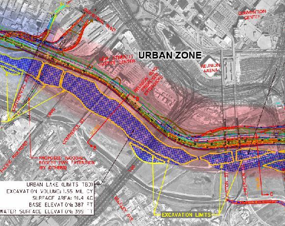
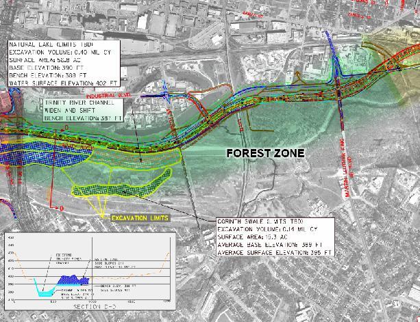
2 Current Activities Flood Protection Why do we need flood protection? During the flood of 1908, the Trinity River was 50 ft. deep and a mile wide This was a 100 year flood event and it occurred 100 years ago! 8 Why do we need flood protection? Why do we need flood protection? Corinth St. Lights at Moore Park Flood of Flood of Flood Protection: Dallas Floodway Extension Levees Upper chain of wetlands Lower chain of wetlands River relocation Recreation and mitigation (throughout What is a wetland cell? -A shallow pool with tiered edges -Used for flood conveyance in the forest -Also improves wildlife habitat, water quality forest)

 Cell G, former site of Sleepy Hollow Golf Course 13 Construction Bridge from")


3 Flood Protection: Lower Chain of Wetlands Flood Protection: Lower Chain of Wetlands Cell D, at IH-45 and Overton Rd. Access from Joppa into wetlands area (end of Fellows Ln.) Cell G, former site of Sleepy Hollow Golf Course 13 Construction Bridge from Loop 12 to Cell G will remain as access point 14 Flood Protection: Future Work Lamar Levee Upper Chain of Wetlands Cadillac Heights Levee 15 Flood Protection: Next Steps Wetland plantings will begin for lower chain of wetlands later this year Upper chain of wetlands will begin construction in summer 2009, complete in summer 2011 Levees will begin construction in early 2011, complete in late Current Activities Recreation Lakes & Amenities Includes River meanders Trails Amphitheaters Gathering places Picnic facilities Wetlands Complete in


")
4 Recreation: The Great Trinity Forest 6,000 acres of bottomland hardwood forest Many bird and wildlife species Recreation: Moore Gateway Park Moore Park Gateway Phase I (complete May 2009) Located at 8 th Street and Corinth, near the DART rail station Moore Park Gateway Phase 2-4 (complete December 2012) Recreation Santa Fe Trestle Trail Standing Wave Whitewater Course


5 Recreation: Standing Wave Corinth St. DART Santa Fe Trestle Trail Recreation: Texas Buckeye Trail MLK, Jr. Blvd. Texas Buckeye Trail Recreation: Texas Buckeye Trail Recreation: Existing Trails in Rochester Park Trailhead Kiosk Covered Pavilion Recreation: Future Trails Network Trinity Trails Phase I Trinity Trails Phase II Recreation: Gateway Parks Several gateway parks are planned and will begin design soon: Loop 12 Gateway (construction begins 5/2010) IH-20 Gateway (construction begins 6/2010) South Central/Joppa Gateway (construction begins 12/09) Improvements to Rochester Park Gateway (construction begins 12/09)


6 Recreation: Gateway Parks Fishing Facilities Recreation in South Dallas Pavilion Soft Surface Trails Trinity Horse Park Parking Loop 12 Boat Launch Recreation: Trinity River Audubon Center Trinity River Audubon Center South of Loop 12, east of IH-45 Designed by renowned LEED (Leadership in Energy and Environmental Design) Architect Antoine Predock Trinity River Audubon Center Trinity River Audubon Center Grand Opening for the Public October 18-19,


7 Recreation: Clean up! Recreation: Clean up! Gates and bollards will be installed at various access points to prevent vehicular access, which has been the source of illegal dumping and other illegal activities These wooden bollards have been installed at Rochester Park to prevent vehicular access over the levee and into the Great Trinity Forest. Areas that have illegal dumping will be cleaned up to make way for trails, wetlands, and parks Volunteer groups have also organized cleanup events in the Trinity River corridor Land Use Plan Economic Development 40 Comprehensive Land Use Plan 23 Study Areas Identified Rochester Park 41 Land Use Opportunities: Residential (neighborhood infill), portals and trails to the Trinity River 42 7

, major")


8 Forest Heights Neighborhood Ideal Neighborhood Land Use Opportunities: Residential, community retail, some Land Use Opportunities: Residential (neighborhood infill), major multi-family 43 highway changes create potential for office and community retail 44 Ideal Neighborhood Urban Design Framework South Lamar 45 Land Use Opportunities: new levee and parkway provide catalytic event that can trigger major changes; potential for commercial, retail, 46 entertainment and office uses South Lamar Urban Design Framework Lamar Center Prototype Site Plan


 Eight SDEIS alternatives from $1.")


9 South Lamar Potential Development Transportation: Trinity Parkway Toll Road 49 Trinity Parkway Overview Trinity Parkway Status Approximately nine miles (IH 35E/SH 183 to U.S. 175/SH 310) Eight SDEIS alternatives from $1.1 to $2.1 billion Schematic design of Alt. 3C proceeding at risk, with TxDOT and Regional Transportation Council support Beat 2014 strategy Begin construction mid Complete construction before Design Criteria Manual Design Criteria Manual Column Design Exhibit


10 Design Criteria Manual Zones Design Criteria Manual Zones Design Criteria Manual Zones Design Criteria Manual Zones Design Criteria Manual Zones Design Criteria Manual Zones


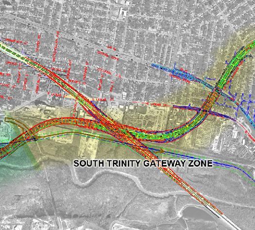
11 South Trinity Gateway Zone South Trinity Gateway Zone Inventory / Analysis Opportunities Conceptual Lighting Plan Transportation: S.M. Wright Parkway The NTTA s desire is to light the Trinity Parkway at entrance/exit ramps and frontage roads Project Study Area SM Wright Freeway Ideal Neighborhood Today s Commuter Flow Lamar US 175 Future Commuter Flow Rochester Park IH 45 Proposed Trinity Parkway Proposed Trinity Parkway 45 N Project Location Map 65 Trinity Parkway Traffic 66 11
 Trinity Parkway SM N")


 Option B2 Trinity")
 Trinity Parkway Trinity")


12 CF H 17 US n( aw Option A Lamar Overpass 5) Trinity Parkway SM N 310 r ma La H ht (S MA R ht W rig Wrig. S.M LA ) Existing SM Wright at CF Hawn 68 Option B1 Trinity Parkway Overpass (open under bridge) Option B2 Trinity Parkway Overpass (closed under bridge) Trinity Parkway Trinity Parkway SM SM ht ht Wrig Wrig r ma La r ma La Trinity Parkway S.M. Wright Parkway South Trinity Gateway Zone Under Bridge Opportunities City of Dallas Future Land Use Plan Residential Commercial Office Retail Entertainment
13 Trinity Parkway S.M. Wright Parkway City of Dallas Opportunities Conceptual Plan Trinity Parkway S.M. Wright Parkway City of Dallas Opportunities Conceptual Plan Trinity Parkway S.M. Wright Parkway Trinity Parkway S.M. Wright Parkway City Of Dallas Opportunities Conceptual Plan City Of Dallas Opportunities Conceptual Plan Sketch Rendering for Under Bridge Development Input needed! What is your preference for the intersection of Trinity Parkway and S.M. Wright Parkway? Option A Trinity Parkway over Lamar, under S.M. Wright Parkway Option B1 Trinity Parkway over Lamar, over S.M. Wright Parkway (open under bridge) Option B2 Trinity Parkway over Lamar, over S.M. Wright Parkway (closed under bridge) Frequently Asked Questions 77 13

 Family oriented Recreational Opportunities Trails for hiking, biking, horseback riding Park & picnic facilities Birdwatching, nature activities 79 80 Why do we need the levees and wetlands?")

14 How will the Trinity Project improve my quality of life? Enhanced mobility Trinity Parkway will provide easy access into and through downtown S.M. Wright Parkway will have slower speeds, less traffic and pedestrian amenities Increased flood protection Levees will protect from the 800 year flood event Stormwater drainage improvements will prevent flooding outside the levees How will the Trinity Project improve my quality of life? (cont.) Family oriented Recreational Opportunities Trails for hiking, biking, horseback riding Park & picnic facilities Birdwatching, nature activities Why do we need the levees and wetlands? The existing Dallas levees were originally built in the 1920 s, raised to their current height in the 1960 s Levees stopped at the point of protecting low income, minority neighborhoods and businesses Their height in the 60 s was to protect from the 800 year flood Flood protection has been reduced to 300 year protection due to upstream development and downstream forest growth Levees will provide 5 ½ miles more protection to Lamar and Cadillac Heights (to 800 year flood protection) and will increase existing Rochester levee protection to 800 year protection (from existing 110 year protection) Wetlands reduce flood levels by providing flood conveyance through the Great Trinity Forest Why do we need the Trinity Parkway? Dallas has one of the top 10 bottlenecks in the country through the Canyon/Mixmaster and lower Stemmons area Dallas is also in a non-attainment area with regard to ozone levels Trinity Parkway will carry 100,000 vehicles per day, and reduce ozone emissions by 84 tons per year Trinity Parkway allows for the reduced speed and enhanced design of SM Wright Parkway Will my property be affected? See the maps provided at this meeting If your property is shown to be affected, you will be contacted by City staff to initiate the acquisition process Individual properties are handled on a case-by-case basis (businesses, single family, renters, etc.) At a minimum, affected owners will receive: Fair Market Value offer (not just DCAD value) Relocation costs Moving costs Property acquisition is in accordance with Federal Regulations City staff are here to answer your questions if you are affected How will the Trinity Parkway affect Economic Development in this area? Parkway and levee extension will create developable land along the Trinity River the catalytic change that brings opportunity. Access and rooftops are keys to successful development. The above public improvements will set the stage. The City can help further by providing needed infrastructure and zoning to entitle desired development. The City and community should create a cohesive vision for each area. The City can further assist by providing: Relocation alternatives for non-conforming uses Economic development tools in the appropriate situation, or Development packages to potential developers
15 Trinity River Project Office (214) ftp://ftp.dallascityhall.com 15
Memorandum. JiiVA. Jord, P.E. Assistant City Manager CITY OF DALLAS. Honorable Mayor and Members of the City Council
 Memorandum DATE November 14, 2008 CITY OF DALLAS TO Honorable Mayor and Members of the City Council SUBJECT What the Trinity River Corridor Project Means for the West Side of Dallas The attached briefing
[Leveraging & Improving Neighborhood Connections] Area C Lamar Levee
![[Leveraging & Improving Neighborhood Connections] Area C Lamar Levee](/thumbs/78/78438669.jpg "[Leveraging & Improving Neighborhood Connections] Area C Lamar Levee") Community Charrette LINC Dallas [Leveraging & Improving Neighborhood Connections] Area C Lamar Levee 06.02.12 LINC Workshop Area C Schematic design has been completed on plans to extend the east levee
Community Charrette LINC Dallas [Leveraging & Improving Neighborhood Connections] Area C Lamar Levee 06.02.12 LINC Workshop Area C Schematic design has been completed on plans to extend the east levee
State Highway 121 Southwest Parkway. Fort Worth s Transportation Success Story in Design and Cooperation
 State Highway 121 Southwest Parkway Fort Worth s Transportation Success Story in Design and Cooperation Greater Fort Worth Association of Realtors October 24, 2007 Presented by: Dan Lamers, P.E. North
Southern Gateway Project and Public Green
 Southern Gateway Project and Public Green Transportation and Trinity River Project Committee May 23, 2016 Purpose of Presentation Provide the history and an overview of the Southern Gateway Project (SGP)
II. VISION. Parks & Recreation. component: II. VISION
 II. VISION component: 3 Parks & Recreation Dallas has an historic opportunity to create what could well become the largest urban park in the nation. A Trinity Central Park within the Dallas Floodway will
Memorandum CITY OF DALLAS
 Memorandum DATE September 23, 2016 CITY OF DALLAS TO The Honorable Members of the Transportation and Trinity River Project Committee: Lee M. Kleinman (Chair), Deputy Mayor Pro Tem Erik Wilson (Vice-Chair),
Comprehensive Plan Advisory Panel Meeting #3
 Comprehensive Plan Advisory Panel Meeting #3 November 7, 2016 Agenda 1. September 19 th Meeting Notes 2. Summary of Focus Areas Charrette 3. Heart of the City Focus Area a. HOC2/Station Areas Concept &
Elm Fork Land Use. Trinity River Corridor Project Committee May 13, 2013
 Elm Fork Land Use Trinity River Corridor Project Committee May 13, 2013 Purpose Discuss Trinity River planned Land Use and Appropriate Compatible Uses, particularly with respect to the Elm Fork Area 2
BUDGETING FOR OUTCOMES TRINITY RIVER CORRIDOR
 BUDGETING FOR OUTCOMES TRINITY RIVER CORRIDOR Trinity River Corridor Team Members: Kelly High, Streets Department Megan Lam, Office of Financial Services Mike Mikeska, Dallas Water Utilities Diana Ochoa,
The Trinity River Corridor, offering Dallas areas of natural
 IMPLEMENTATION PLAN FOR THE TRINITY RIVER CORRIDOR The Trinity River Corridor, offering Dallas areas of natural beauty and untapped potential, runs through the heart of the city. Proposed improvements
Northwest Corridor LRT Line to Irving/DFW Public Meeting No. 1 Project Overview
 LRT Line to Irving/DFW Public Meeting No. 1 Project Overview January 21, 2004 Agenda Purpose Corridor Background Environmental Impact Assessment Public Involvement Plan Project Schedule Purpose Project
SH 199 Corridor Master Plan. Community Meeting No. 2 May 31, 2017
 Community Meeting No. 2 May 31, 2017 Transportation Projects On or Near SH 199 SH 199 from 0.3 miles south of FM 1886 to south end of Lake Worth bridge Construct freeway mainlanes and frontage roads 10-Year
The Emerald Bracelet Dallas, Texas. October 2005
 The October 2005 TABLE OF CONTENTS: Tab I Project Summary Master Illustrative Plan Tab II Woodall Rodgers Freeway Segment Tab III U.S. Highway 75 Segment Tab IV Interstate Highway 30 Segment Tab V Interstate
I-84 Hartford Project Open Planning Studio #12. April 25, 2017
 I-84 Hartford Project Open Planning Studio #12 April 25, 2017 Meeting Agenda 1. I-84 Hartford Project alternatives update 2. Multimodal station area planning 3. I-84 / I-91 Interchange Study coordination
Honorable Members of the Mobility Solutions, Infrastructure and Sustainability Committee
 Memorandum DATE January 23, 2019 CITY OF DALLAS TO Honorable Members of the Mobility Solutions, Infrastructure and Sustainability Committee SUBJECT I-30 East Project Update On Monday, January 28, 2019,
City of Los Angeles Department of Public Works
 City of Los Angeles Department of Public Works Environmental Scoping Meeting for the Proposed Sixth Street Park, Arts, River & Connectivity Improvements (PARC) Project May 3, 2017 1 Agenda Introductions
Green Gables. April 24, 2013
 Green Gables Preliminary and Final Plat April 24, 2013 Development Team Green Gables Development Corporation (Owner/Developer) DTJ Design (Planner/Landscape Architect) Enertia Consulting Group (Civil Engineer)
The bottom urban structure and guidelines City Council Briefing
 The bottom urban structure and guidelines City Council Briefing 4.1.2015 1 Provide information on the studio s community planning and design efforts for The Bottom Review process to date Review plan recommendations
Memorandum CITY OF DALLAS. Riverfront Boulevard Design From Continental Avenue to Cadiz Street
 Memorandum DATE November 10, 2011 CITY OF DALLAS TO Trinity River Corridor Project Committee Members: Vonciel Jones Hill (Chair) Linda Koop (Vice Chair), Monica Alonzo, Scott Griggs, Angela Hunt, and Delia
Reconnecting New Haven: Downtown Crossing
 Reconnecting New Haven: Downtown Crossing Phase 2 Update Introduction to Phase 3 November 16, 2017 City of New Haven, Connecticut Toni N. Harp, Mayor Reconnecting New Haven Introduction Project Overview
C)49~ Memorandum CITY OF DALLAS
49~ Memorandum CITY OF DALLAS") Memorandum DATE 19 August 2014 CITY OF DALLAS TO The Honorable Members of the Transportation and Trinity River Project Committee: Vonciel Jones Hill (Chair), Lee Kleinman (Vice Chair), Deputy Mayor Pro
Memorandum DATE 19 August 2014 CITY OF DALLAS TO The Honorable Members of the Transportation and Trinity River Project Committee: Vonciel Jones Hill (Chair), Lee Kleinman (Vice Chair), Deputy Mayor Pro
Minto-Brown Island. November 18, City of Salem, Parks & Transportation Services
 Minto-Brown Island Park Master Plan Public Meeting #1 November 18, 2014 City of Salem, Parks & Transportation Services Division, i i Public Works Welcome... and thanks for participating in the master planning
Longmeadow Parkway Fox River Bridge Corridor. August 6, 2015
 Longmeadow Parkway Fox River Bridge Corridor August 6, 2015 Longmeadow Parkway Bridge Corridor 5.6 miles from Huntley Road to IL 62 Unique municipal/county/state/federal partnership Links Randall Road
DOMINION BOULEVARD CORRIDOR STUDY AND ECONOMIC DEVELOPMENT STRATEGIC PLAN A MODEL FOR CHESAPEAKE S FUTURE
 DOMINION BOULEVARD CORRIDOR STUDY AND ECONOMIC DEVELOPMENT STRATEGIC PLAN A MODEL FOR CHESAPEAKE S FUTURE Overview I. Draft Plan Process II. Draft Plan Overview a. Market Analysis b. Master Land Use Plan
Welcome! to Keller Town Hall
 Welcome! to Keller Town Hall Keller Town Center Planning a New Downtown What is Keller Town Center? A new, growing downtown district planned as an urban village A combination of retail and office spaces,
Trinity River Park Design Guidelines for the Trinity River Corridor Project Committee August 19, 2008
 Memorandum DATE August 15, 2008 CITY OF DALLAS TO Trinity River Committee Members: David A. Neumann (Chairman) Mayor Pro Tern Dr. Elba Garcia (Vice-Chair) Deputy Mayor Pro Tern Dwaine Caraway Carolyn R.
Portage Parkway Environmental Assessment Public Information Centre No. 1
 City of Vaughan Portage Parkway Environmental Assessment Public Information Centre No. 1 November 25, 2015 Welcome to the Public Information Centre This first Public Information Centre (PIC) introduces
City of Missoula and Missoula County Open Space Planning Open House
 City of Missoula and Missoula County Open Space Planning Open House FEBRUARY 6, 2018 The following slides contain the display board content from the open house. Please use boards to answer questions in
Q:%4~ Memorandum CITY OF DALLAS
 Memorandum DATE December 10, 2010 CITY OF DALLAS TO Members of the Transportation and Environment Committee: Linda Koop (Chair), Sheflie Kadane (Vice Chair), Pauline Medrano, Vonciel Jones Hill, Jerry
Farmers Investment Co. (FICO) Continental Farms
 Continental Farms") Farmers Investment Co. (FICO) Continental Farms Planning & Zoning Commission Study Session (River Master Plan) January 25, 2012 FICO Property 7,000 acres total area 6,000 acres in Town of Sahuarita 1,000
Farmers Investment Co. (FICO) Continental Farms Planning & Zoning Commission Study Session (River Master Plan) January 25, 2012 FICO Property 7,000 acres total area 6,000 acres in Town of Sahuarita 1,000
A BLUEPRINT FOR BROCKTON A CITY-WIDE COMPREHENSIVE PLAN
 A BLUEPRINT FOR BROCKTON A CITY-WIDE COMPREHENSIVE PLAN Public Meeting October 2016 1 Plan Summary and Discussion Public Meeting May 4 2017 City of Brockton Bill Carpenter, Mayor Department of Planning
Exhibit A. SH 161 RTC Work Program of New Projects. Collin County
 Exhibit A SH 161 RTC Work Program of New Projects Collin County 0918-24-969 N/A 0918-24-970 N/A 0918-24-973 N/A 2351-01-020 N/A 2679-03-010 N/A On Exchange Parkway from US 75 to Allen Heights On Country
City of Dallas Plans
 City of Dallas Plans Name Year 1. A Report on a Sheltered Pedestrian System in CBD 1979 2. A Report on the Public Uses of Block 250 1980 3. Achieving the Goals for Dallas 1978 4. Amendments to the City
BURTON STATION STRATEGIC GROWTH AREA PLAN UPDATE PUBLIC MEETING 3/26/18
 BURTON STATION STRATEGIC GROWTH AREA PLAN UPDATE PUBLIC MEETING 3/26/18 1 WHERE WE ARE? 2 PRIMARY OBJECTIVES OF THE PLAN UPDATE 1. Update the land use designation for Burton Station Village to reflect
Description of Preferred Alternative
 Chapter 2 Description of Preferred Alternative 2.1 Introduction This chapter of the programmatic Sammamish Town Center Sub-area Plan Final EIS provides a more detailed description of the Preferred Alternative
To: Planning Commission D.. June 3, 2009
 Agenda Item No. 9(a~ CITY OF WOODINVILLE, WA REPORT TO THE PLANNING COMMIS ION 17301 133 1'd Avenue NE, Woodinville, WA 98072 WWW.CI.WOODINVILLE.WA.US To: Planning Commission D.. June 3, 2009 From: Subject:
BENJAMIN BANNEKER PARK FRAMEWORK PLAN (PLAN ADOPTION)
") BENJAMIN BANNEKER PARK FRAMEWORK PLAN (PLAN ADOPTION) COUNTY BOARD MEETING DECEMBER 16, 2017 County Board Consideration: Adopt the Benjamin Banneker Park Framework Plan and Design Guidelines Framework
BENJAMIN BANNEKER PARK FRAMEWORK PLAN (PLAN ADOPTION) COUNTY BOARD MEETING DECEMBER 16, 2017 County Board Consideration: Adopt the Benjamin Banneker Park Framework Plan and Design Guidelines Framework
City of Iowa City Department of Neighborhood and Development Services Department of Parks and Recreation Department of Public Works City Manager s
 RFP Pre-submittal meeting December 18, 2015 City of Iowa City Department of Neighborhood and Development Services Department of Parks and Recreation Department of Public Works City Manager s Office Background
City of Nogales General Plan
 Open Space, Parks, Recreation and Trails City of Nogales General Plan Residents of Nogales place a high priority in the development of a comprehensive system of open space, parks, recreation and trails
Pine Island Road Corridor Master Plan
 RECOMMENDED DEVELOPMENT PLAN Figure 9: Del Prado Village District Conceptual Framework The Conceptual Framework (Figure 8) for development of the Pine Island Corridor is to encourage mixed-use development
[Leveraging & Improving Neighborhood Connections] Area A Riverfront
![[Leveraging & Improving Neighborhood Connections] Area A Riverfront](/thumbs/87/97077022.jpg "[Leveraging & Improving Neighborhood Connections] Area A Riverfront") Community Charrette LINC Dallas [Leveraging & Improving Neighborhood Connections] Area A Riverfront 06.02.12 LINC Workshop Area A PDs 774 and 784 cover the majority of Area A employing a form based code
Community Charrette LINC Dallas [Leveraging & Improving Neighborhood Connections] Area A Riverfront 06.02.12 LINC Workshop Area A PDs 774 and 784 cover the majority of Area A employing a form based code
Enhance the High Line Canal Projects
 Enhance the High Line Canal Projects Joint Project Proposal for Arapahoe County Open Spaces Funding Partner Sponsors: South Suburban Park and Recreation District City of Centennial City of Littleton October
SAN RAFAEL GENERAL PLAN 2040 INTRODUCTION AND OVERVIEW
 SAN RAFAEL GENERAL PLAN 2040 INTRODUCTION AND OVERVIEW Steering Committee Presentation February 14, 2018 Purpose of General Plan Guide land use and development decisions Coordinate transportation, infrastructure,
Parks, Trails, and Open space Element
 Parks, Trails, and Open space Element Parks, Trails, and Open Space element Parks, Recreation, and Open Space are important components of the quality of life desired by the residents of Elk Grove. This
Remi Mendoza City Planning Academy March 13, 2017
 Remi Mendoza City Planning Academy March 13, 2017 1 What is the General Plan? The 2030 General Plan 5-Year Update (2035 General Plan) Questions and Answers 2 Guidebook for development and growth Required
ITA and Vicinity Master Plan Update
 1 ITA and Vicinity Master Plan Update PHASE 3 SEPTEMBER 27, 2017 Three Phase Process 2 Phase 1 - Understanding October 13th Public Meeting Phase 2A - Exploring Ideas November 17th Public Meeting Phase
South Davis County COMMUNITY SPOTLIGHT
 South Davis County COMMUNITY SPOTLIGHT Davis/SLC Community Connector Bus Rapid Transit line connecting SLC & Davis County RTP Phase 1 Project Generate 3,100 average weekday riders Relieve congestion on
Open House RIVER DES PERES GREENWAY: LANSDOWNE SHREWSBURY METROLINK TO FRANCIS R. SLAY PARK
 Open House 10.12.16 RIVER DES PERES GREENWAY: LANSDOWNE SHREWSBURY METROLINK TO FRANCIS R. SLAY PARK MEETING AGENDA Great Rivers Greenway and Project Partners River des Peres Greenway Overview Project
Mendota Heights 2040 Comprehensive Plan Draft Vers
 4 Parks and Trails The City of Mendota Heights boasts a variety of recreational and open space opportunities. Few cities can claim access to regional trails, riverside and lakeside parks, scenic bluffs
2035 General Plan Update and Belmont Village Specific Plan. Joint Study Session with the City Council and Planning Commission April 12, 2016
 2035 General Plan Update and Belmont Village Specific Plan Joint Study with the City Council and Planning Commission April 12, 2016 Agenda 1. Welcome and Introductions 2. General Plan Update Status of
POCKET COMMUNITY PLAN
 POCKET COMMUNITY PLAN Part Three : COMMUNITY PLAN AREAS AND SPECIAL STUDY AREAS CONTENTS Community Location... 3-P-3 Community Vision... 3-P-4 Community Profile... 3-P-4 Community Issues... 3-P-6 Land
Turkey Creek Streamway Corridor
 Turkey Creek Streamway Corridor Turkey Creek Corridor Overview History Watershed Corridor Inventory Coalition Corridor Plan Stages of Development Benefits Funding Turkey Creek History Kansas and Missouri
East River Waterfront Esplanade and Piers New York, New York Draft Environmental Impact Statement
 East River Waterfront Esplanade and Piers New York, New York Draft Environmental Impact Statement October 12, 2006 CEQR No.: TO COME ULURP Nos.: TO COME Lead Agency: Lower Manhattan Development Corporation
Town Center (part of the Comprehensive Plan)
") Town Center (part of the Comprehensive Plan) Mercer Island Town Center Looking North (2014) In 1994, a year-long process culminated in a set of design guidelines and code requirements for the Town Center
Town Center (part of the Comprehensive Plan) Mercer Island Town Center Looking North (2014) In 1994, a year-long process culminated in a set of design guidelines and code requirements for the Town Center
Joe Pool Lake Master Plan Revision Public Information Meeting May 23, 2017
 Joe Pool Lake Master Plan Revision Public Information Meeting May 23, 2017 Presented By Jason Owen Lake Manager U.S. Army Corps of Engineers Fort Worth District US Army Corps of Engineers Purpose of this
Burton Station Village Community Meeting February 26, 2014
 February 26, 2014 SGA Plan Overview Recent announcements by the City of Norfolk regarding the closure of Lake Wright Golf Course and retail development proposals Update on infrastructure improvement plans
Northwest Rail Corridor and US 36 BRT Development Oriented Transit Analysis 4.4 STATION AREA FINDINGS
 4.4 STATION AREA FINDINGS Each station is different, and each one requires a separate set of recommendations based on the vision for the site. This section outlines an initial TOD strategy and recommendations
PLAN ELEMENTS WORKSHOP. April 5, 2016
 PLAN ELEMENTS WORKSHOP April 5, 2016 needs more housing. But there is no one-size fits-all solution. Every neighborhood has its own character. In some places, density is not only appropriate it is badly
WELCOME! 8 8:30 6: TH STREET IMPROVEMENTS. Open House. Presentation & Q&A
 WELCOME! 168 TH STREET IMPROVEMENTS 6:30 Open House 7 8 Presentation & Q&A 8 8:30 Open House WELCOME Todd Pfitzer City of Omaha Engineer Bob Stubbe City of Omaha Public Works Director Jon Meyer Project
BROOKHILL NEIGHBORHOOD MODEL ZONING MAP AMENDMENT PREFACE TO APPLICATION
 BROOKHILL NEIGHBORHOOD MODEL ZONING MAP AMENDMENT PREFACE TO APPLICATION June 15, 2015 Revised: August 1, 2016 I. VISION Brookhill is a proposed community based upon the principles of Albemarle County
S A C R A M E N T O C O U N T Y JACKSON HIGHWAY & GRANT LINE EAST VISIONING STUDY
 JACKSON HIGHWAY & GRANT LINE EAST S A C R A M E N T O C O U N T Y P L A N N I N G D E P A R T M E N T SUMMARY AND WORKBOOK November 19, 2008 History of the Visioning Study Sacramento County has two growth
Sustainable Development Call for Projects
 Sustainable Development Call for Projects 2005-2006 Infrastructure Project Examples *Note: This list is not all inclusive, but a sampling of the types of projects that were awarded funds. 137 Projects
Atlanta BeltLine Corridor Environmental Study. Scoping Meeting August 2008
 Atlanta BeltLine Corridor Environmental Study Scoping Meeting August 2008 What Will We Be Discussing Today? Study Overview - How Did We Get Here? - What Is the Study About? - Who Is Involved? - Where Is
Courthouse Square Planning & Urban Design Study. Courthouse Square Working Group #13 October 15, 2014
 Courthouse Square Planning & Urban Design Study Courthouse Square Working Group #13 October 15, 2014 1 Courthouse Square Process Working Group Community Courthouse Square Advisory Groups & Civic Associations
Gold Line Bus Rapid Transit Transit Oriented Development (BRTOD) Helmo Station Area Plan
 Helmo Station Area Plan") Appendix F Gold Line Bus Rapid Transit Transit Oriented Development (BRTOD) Helmo Station Area Plan Introduction and Purpose of the Plan The Gold Line Bus Rapid Transit facility is an eleven-mile dedicated
Appendix F Gold Line Bus Rapid Transit Transit Oriented Development (BRTOD) Helmo Station Area Plan Introduction and Purpose of the Plan The Gold Line Bus Rapid Transit facility is an eleven-mile dedicated
GATEWAY AREA STRUCTURE PLAN
 CHESTERMERE GATEWAY AREA STRUCTURE PLAN COMMUNITY OPEN HOUSE SEPTEMBER 22 nd, 2015 PLAN AREA ± 512 hectares (± 1,265 acres) GATEWAY LOCATION UNDEVELOPED LANDS PRESENT AGRICULTURAL USE REGIONAL LAND USE
1.0 Introduction. Purpose and Basis for Updating the TMP. Introduction 1
 1.0 Introduction The Town of Castle Rock is situated between the metropolitan areas of Denver and Colorado Springs, amidst a unique terrain of rolling hills, mesas, ravines, and waterways. Like many Front
Public Open House. Welcome! Presentation at 5:15 p.m. Please sign-in at the registration table
 Public Open House Welcome! Presentation at 5:15 p.m. Please sign-in at the registration table The Grand Avenue Extension Location and Environmental Study will determine the location of the extension of
Isabel Neighborhood Plan: Alternatives
 Isabel Neighborhood Plan: Alternatives Presented by: Lori Parks, Associate Planner February 2, 2015 Agenda 1. Background on BART to Livermore 2. Isabel Neighborhood Plan 3. Alternative Scenarios 4. General
CHAPTER 7: Transportation, Mobility and Circulation
 AGLE AREA COMMUNITY Plan CHAPTER 7 CHAPTER 7: Transportation, Mobility and Circulation Transportation, Mobility and Circulation The purpose of the Transportation, Mobility and Circulation Chapter is to
Cobb County Design Guidelines Mableton Parkway & Veterans Memorial Highway Community Design Workshop January 12, 2017
 Community Design Workshop January 12, 2017 Agenda Opening Remarks / Introductions Scope of Work Existing Conditions Key Issues / Opportunities VPS Summary Draft Vision & Goal Statement Implementation Concepts
Department of Community Development. Planning and Environmental Review Division Revised Notice of Preparation
 Department of Community Development Michael J. Penrose, Acting Director Divisions Building Permits & Inspection Code Enforcement County Engineering Economic Development & Marketing Planning & Environmental
North Oakville East Parks Facilities Distribution Plan. November, 2009
 North Oakville East November, 2009 POLICY CONTEXT 1) Purpose a) The purpose of this document is to be a guide for the location, configuration, design and development of the parks system for the North Oakville
BISCUIT RUN PARK MASTER PLAN
 BOARD OF SUPERVISORS November 14, 2018 BISCUIT RUN PARK MASTER PLAN COUNTY OF ALBEMARLE ANHOLD ASSOCIATES Contents Project Introduction Property Background County Park Planning Process Existing Site &
Planning Districts INTRODUCTION
 INTRODUCTION To facilitate detailed examination of development prospects for all areas of the community, Delano has been divided into 14 planning districts. The location of these planning districts is
T H A T E V E R Y O N E
 B R I N G I N G C H A N G E T H A T E V E R Y O N E C A N F E E L. AT CHW, we survey, plan, design, engineer, administer and inspect with a purpose: to positively transform the communities we serve. From
Green Infrastructure The Indianapolis Greenways Connection
 Green Infrastructure The Indianapolis Greenways Connection Fewer things in the transportation industry today make better since than combining the needs for pedestrian and bike trails with the need to locate,
Introduction. Chapter 1. Purpose of the Comprehensive Plan Plan Organization Planning Process & Community Input 1-1
 Chapter 1 Introduction Lakewood 2025: Moving Forward Together Purpose of the Comprehensive Plan Plan Organization Planning Process & Community Input 1-1 Purpose of the Comprehensive Plan The Comprehensive
ADOPTED CAPITAL IMPROVEMENT PROGRAM BUDGET ARROYO PROJECTS
 ADOPTED CAPITAL IMPROVEMENT PROGRAM BUDGET ARROYO PROJECTS HAHAMONGNA FY 212-216 Capital Improvement Program Priority Description Total Estimated Costs Appropriated Through FY 211 Adopted FY 212 FY 213
SOUTHWEST CORRIDOR EXTENSION. Environmental Evaluation and Basic Engineering Results PUBLIC MEETING/OPEN HOUSE November 18, 2009
 SOUTHWEST CORRIDOR EXTENSION Environmental Evaluation and Basic Engineering Results PUBLIC MEETING/OPEN HOUSE November 18, 2009 AGENDA I. Welcome/Introductions II. Project Review and Status III. Environmental
Dwelling Units Max 12 dwelling units per acre/min 8 dwelling units per acre. Development Mix 80% non residential/20% residential
 13. OSTEEN LOCAL PLAN Background: The Osteen Local Plan area is located in southwest Volusia County along the SR 415 corridor between Lemon Bluff Road and Acorn Lake Road and includes 3,990 acres. The
Parks, Trails, and Open Space Element
 P arks, Recreation, and Open Space are important components of the quality of life desired by the residents of Elk Grove. This Element of the General Plan addresses the City s goals, policies, and actions
Definitions. Average Daily Traffic Demand (ADT): The actual number or projected number of cars that pass a point in a 24-hour period.
: The actual number or projected number of cars that pass a point in a 24-hour period.") Definitions Access Management: A combination of physical techniques and transportation policies used to control the flow of traffic between roads and the surrounding lands. Alternative City Form Scenarios:
Definitions Access Management: A combination of physical techniques and transportation policies used to control the flow of traffic between roads and the surrounding lands. Alternative City Form Scenarios:
Balancing Conservation and Development on the Jordan River
 Balancing Conservation and Development on the Jordan River Jordan River Parkway Trail Regional Athletic Complex Conservation & Restoration Balancing Conservation and Development on the Jordan River Jordan
The transportation system in a community is an
 7 TRANSPORTATION The transportation system in a community is an important factor contributing to the quality of life of the residents. Without a sound transportation system to bring both goods and patrons
Public may provide comments on the GDP within the next two weeks (December 24)
") 25/70 General Development Plan (GDP) Public Meeting Wednesday, December 10, 2014 6:00 8:00 P.M. District 1 Police Station Community Room 1311 W 46th Ave, Denver, CO 80211 Council Woman Montero: This particular
25/70 General Development Plan (GDP) Public Meeting Wednesday, December 10, 2014 6:00 8:00 P.M. District 1 Police Station Community Room 1311 W 46th Ave, Denver, CO 80211 Council Woman Montero: This particular
The Illinois Department of Transportation and Lake County Division of Transportation. Route 173, including the Millburn Bypass
 The Illinois Department of Transportation and Lake County Division of Transportation welcome you to this Public Hearing for U.S. Route 45 from Illinois Route 132 to Illinois Route 173, including the Millburn
4 C OMMUNITY D ISTRICTS
 4 C OMMUNITY D ISTRICTS N ew development in the Area will include many different types of land uses, including a destination retail area that attracts people from all over the region; recreation opportunities
Edgeley Pond + Park Public Meeting
 Edgeley Pond + Park Public Meeting February 21, 2017 Purpose of the meeting This Public Meeting is an opportunity for you to review the project background, process and provide input. City of Vaughan staff
COLLIER BOULEVARD (CR 951) CORRIDOR
 CORRIDOR") Project(s) Goals Improve Traffic Circulation, Capacity & Safety Focus on Safety During Design & Construction Address Public Concerns Design an Aesthetically Pleasing Project Limit Environmental Impacts
Project(s) Goals Improve Traffic Circulation, Capacity & Safety Focus on Safety During Design & Construction Address Public Concerns Design an Aesthetically Pleasing Project Limit Environmental Impacts
PARTF Scoring System for Grants
 PARTF Scoring System for Grants The members of the N.C. Parks and Recreation Authority use the PARTF scoring system as one of several tools to select grant recipients. Please provide all of the information
open public hearing and allow public comment request to continue LPA public hearing to January 16, 2014 at 10:30 am
 TODAY S AGENDA Work Session LPA Transmittal Public Hearing open public hearing and allow public comment request to continue LPA public hearing to January 16, 2014 at 10:30 am staff will issue a recommendation
Las Colonias Park Master Plan
 2013 Las Colonias Park Master Plan City of Grand Junction June 2013 Introduction Las Colonias Park, a 101 acre parcel on the edge of the Colorado River south of downtown, was deeded to the City of Grand
Authority of the General Plan
 Authority of the General Plan This La Habra Heights General Plan will serve as the blueprint for future planning and development in the City. This General Plan describes the City s vision for the future
Preliminary Sketch Plan for Fort Hunter Park
 Preliminary Sketch Plan for Fort Hunter Park Public Presentation November 19, 2009 Dauphin County Parks and Recreation 100 Fort Hunter Road Harrisburg, PA 17110 (717) 599-5188 www.dauphinc.org THOMAS COMITTA
LAND PARK COMMUNITY PLAN
 LAND PARK Community Plan Part Three : COMMUNITY PLAN AREAS AND SPECIAL STUDY AREAS SACRAMENTO 2030 GENERAL PLAN Contents Community Location...3-LP-3 Community Vision...3-LP-4 Community Profile...3-LP-4
The following principles guide the development of goals and strategies to protect and promote these amenities:
 OPEN SPACE/PARKS/TRAILS/RECREATION GOALS/STRATEGIES Cherry Hills Village is a living environment that offers low density development, open areas, public scenic vistas, public trails and public parks. This
DISCUSSION TOPIC: ST JOHNS RIVER & ITS TRIBUTARIES (BPII) 2030 COMPREHENSIVE PLAN POLICES AND REGULATORY FRAMEWORK
 2030 COMPREHENSIVE PLAN POLICES AND REGULATORY FRAMEWORK") DISCUSSION TOPIC: ST JOHNS RIVER & ITS TRIBUTARIES (BPII) 2030 COMPREHENSIVE PLAN POLICES AND REGULATORY FRAMEWORK St. John s River & Its Tributaries Issue Summary: The St. Johns River is an important
DISCUSSION TOPIC: ST JOHNS RIVER & ITS TRIBUTARIES (BPII) 2030 COMPREHENSIVE PLAN POLICES AND REGULATORY FRAMEWORK St. John s River & Its Tributaries Issue Summary: The St. Johns River is an important
City Council Special Meeting. August 9, 2017
 DREAMPORT VILLAGES CASA GRANDE City Council Special Meeting August 9, 2017 Regional Gateway Commerce Center PAD Casa Grande Mountain Ranch PAD ARICA RD. OVERVIEW Dreamport Villages North 618 acre commercial
HAZARD MITIGATION GOALS AND OBJECTIVES
 SEWRPC Community Assistance Planning Report No. 282, 2nd Edition CITY OF MILWAUKEE ALL HAZARDS MITIGATION PLAN UPDATE Chapter IV HAZARD MITIGATION GOALS AND OBJECTIVES [NOTE: Throughout this plan update