I am writing regarding the SMP update draft as a citizen and a neighbor who is impacted by shoreline uses.
|
|
|
- Nora Bryant
- 5 years ago
- Views:
Transcription
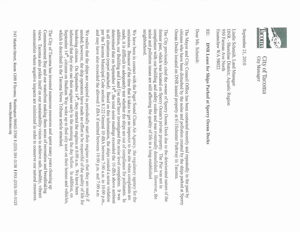
1 From: Rick & Judy Rose Sent: Wednesday, November 03, :00 PM To: Planning; Cc: Boe, David; Woodards, Victoria; Lonergan, Joe; Campbell, Marty; Petty, Ryan; Toso, Aaron (DNR); David E. Rietmann; Carl Teitge; Capell, Jeff (Legal); Subject: SMP draft response November 3, 2010 Stephen Atkinson City of Tacoma Community and Economic Development 747 Market Street 10th fl Tacoma, WA Dear Mr. Atkinson: I am writing regarding the SMP update draft as a citizen and a neighbor who is impacted by shoreline uses. I appreciate the work the City has done in trying to draw out input and feedback to the SMP update. As I read through the SMP draft, I found numerous troubling concerns that involved negative impacts to adjacent uses and public access. These are impacts that will negative impact Tacoma generations for years to come with regard to livability and economically viability. Please find comments and formal request for changes to the SMP draft in order to bring the SMP update more in line with the goals and aspirations of Tacoma citizens. If you have questions regarding some of my comments and suggestions, please do not hesitate to contact me. Sincerely, Rick Rose Stadium_rose@earthlink.net mobile
2 ================================================================================ ======================================== Comments: Bring my 2007 S-7 amendment application into the SMP update analysis: I had submitted an amendment application to City Code that requested a change to the S-7 shoreline district on 12/31/07 and it can be found on the City s website, however, there was neither mention of this amendment application within the SMP draft nor a mention of the concepts within the amendment application. This was an amendment application that went before the Planning Commission and who commented on its salient points and the need for the application to be addressed immediately. The Planning Division pushed back that they needed to do the SMP update first. Why were this amendment application and its desire to address the festering issues within the S-7 not even addressed? This amendment application spelled out the on-going issues with the negative impact and nonconformance of industrial uses with the adjacent residential neighborhood and it contained the goals and aspirations of Tacoma s desire for greater public access to the shoreline. I am requesting this amendment application be brought back into the forefront, addressed as part of the SMP update, and not shelved into some back room. At the time application, the organization Walk the Waterfront had collected greater than 400 petitions in favor of a walkable waterfront free of polluting industrial users. With close to a thousand signatures, it reflects the Tacoma s population desiring a change within the S-7 remove industrial designation and greater public access. If you are unable to find this amendment application, please find it attached to this Description of the proposed shoreline amendment.doc. Include all citizens comments and news articles: It is widely known within the City and among its citizens, there have been an ongoing and growing list of issues dealing with direct industrial impacts on the adjacent residential neighborhood. These issues fall into pollution categories of air, water, noise, light, and bulk. The adjacent neighborhood has continually put up with affronts from industrial users over the years and is fed up no angry as hell. Where is the City in protecting the residents, students and park users as required by City Code? Top at the list of issues is the lack of jurisdiction the City and State of Washington has over vessels or other floating structures not physically attached to an S-7 site coupled with a property owner who continually says he cannot control his tenant who is polluting. Bottom-line, the property owner and their tenant are not absorbing the pollution costs, but it is the adjacent historical neighborhood, schools, parks, and Commencement Bay who absorbing these costs shed from the industrial zone. I am formally requesting the City of Tacoma add into the Shoreline Master Program Update the hundreds of written and verbal public comments and newspaper articles concerning industrial impact on the residential neighborhood, schools, and parks from the 1988 Sperry Ocean Dock permit application, the 2007 Sperry permit application, the 2008 code violation, the 2008 Sperry modified permit application, and the 2010 appeal hearing regarding the Sperry permit. I, also, want the City of Tacoma s position on the industrial impact and the need for public access from the 1988 permit added into the SMP update. These numerous public comments are a critical exhibit to show to the Planning Division, the Planning Commission, the Tacoma City Council, and the Washington State Department of Ecology the disturbing and nagging issues and environmental abuses caused by the S-7 being zoned light industrial and a water terminal and their negative impact with the lack of jurisdiction to enforce City and State regulations. These comments in opposition to the expansion to add new mooring dolphins and 18,400 square feet of overwater parking lot without a current environmental impact study at Sperry Ocean Dock are in the City of Tacoma s possession within the Building and Land Use Department.
3 It is no longer appropriate to zone the area between the McCarver/Ruston Way intersection and Thea's Park as light industrial. It is an outrage to reclassify it as High Intensity as the SMP draft has printed. This shoreline area below Stadium High School and Garfield Gulch should be given the protections of Ruston Way Urban Conservancy S-6. It is time to stop the abuses to our environment, families, school children, pets, gardens and parks.the "light industry" at Sperry Ocean Dock has polluted the 100 year old Stadium-Seminary historic neighborhood, Old Town neighborhood, schools, and parks with acid rain for the past 20 years. The SMP should protect Tacoma citizens, the shoreline and the nearshore aquatic life. No more moorage of marine vessels of any kind should be allowed within 2,000 feet of homes or parks. Read the two file boxes of letters, articles, phone messages and s from the citizens of Tacoma!!! Additions/Deletions/Changes requested to the SMP: (Delete) Adequate space should be reserved on shorelines to meet the current and projected demand for water-dependent uses. (Change to:) Adequate space should be reserved on shorelines to meet the current and projected business and populations demand for water-dependent and water-enjoyment uses. In light of the language in the proposed SMP Shoreline Use Policy (Adequate space should be reserved on shorelines to meet the current and projected demand for water-dependent uses.) coupled with the facts of 1) the current Port of Tacoma shipping volume is down year over year, 2) they have lost business to Seattle, 3) the Port in Prince Rupert, BC is coming on line to compete with Puget Sound shipping business, and 4) the probable negative shipping impact on west coast ports as the result of the Panama Canal widening and upgrade project, there is no logical projected demand for water-dependent use in Tacoma and no logical explanation for the S-7 to be locked down into a designation High Intensity - Deep water moorage and industrial. In a 2005 Puget Sound Shoreline Strategy study conducted by Trust for Public Land concluded: The population of 6 of the 12 counties in the Puget Sound region is forecasted to at least double over the next 20 years. Such population projections will have profound impacts on the intensity and distribution of development and the overall livability and quality of life of communities throughout the region. The waters and shorelines of Puget Sound have an enormous economic impact throughout the region and state. The sound supports some of the state s largest industries including commerce and trade; tourism; and subsistence, recreational, and commercial fisheries. Public access to shorelines and waterways is a critical component of the economic success of these industries. Case in point: 80 percent of the state s tourism revenues are from the Puget Sound region; this figure has doubled over the last 20 years, coupled by a 50 percent increase in touristdependent jobs. It is evident that a change in the shoreline designation from S-7 to S-6 in the Schuster corridor will have a profound positive financial impact on the City of Tacoma and the Puget Sound region. (Delete) 6.2 Site Planning All references to shoreline uses and developments. (Change to) 6.2 Site Planning All shoreline uses, developments, and attached in-water structures. (Add definition) Attached in-water structures can be defined as piers, docks, and vessels permanently fixed to shore or temporarily attached via lines, cables, power lines, sewer lines, chains, etc for a period greater than 30 days.
4 From all the public comments found in the Sperry Ocean Dock permit application files, it is evident the City of Tacoma does not have any jurisdiction over in-water structures and facilities. The above language will give the City of Tacoma teeth for regulating long term in-water structures with regard to height, setbacks, view corridors, light emissions, noise, critical areas impact etc. To date, the Building and Land Use Department has shown it examines only the fixed structure to be developed and not the impact of the long term intended use with regard to height, setbacks, etc of a structure floated to the site and attached. If this change cannot be added, then the intended use of the S-7 should not be Industrial so as to reduce the incompatible impact to the adjacent residential land use. (Delete) B. 1 Water-dependent port, terminal, and industrial uses shall have shoreline location priority over all other uses in the S-7 and S-10 Shoreline Districts. (Change to) B. 1 Water-dependent port, terminal, and industrial uses shall have shoreline location priority over all other uses in the S-10 Shoreline Districts. Water-dependent port, terminal, and industrial uses need to be limited to the S-10 district (Port of Tacoma) so as to minimize the negative impact from water-dependent port, terminal, and industrial uses in the S-7 on immediately adjacent R-2 with no adequate buffer for air, light, and noise pollution. It is an outrage to reclassify it as High Intensity as the SMP draft has printed. This shoreline area below Stadium High School and Garfield Gulch should be given the protections of Ruston Way Urban Conservancy S-6 with water-related uses. (Delete) 9.7 B (S-6 Ruston Way) District Boundary Description. The S-6 Shoreline District boundary extends from the centerline of N 49th Street to the boundary between the Chinese Reconciliation Park and Tahoma Salt Marsh, including only those areas upland to the westernmost extent of the Ruston Way right of way or upland within 200 of the OWHM, and excluding the Sperry Ocean Dock access road. (Change to) 9.7 B (S-6 Ruston Way/Schuster) District Boundary Description. The S-6 Shoreline District boundary extends from the centerline of N 49th Street to the northernmost extent of Thea s Park, including those areas upland within 200 of the OHWM and the entirety of the Sperry Ocean Dock access road. It is clearly evident from the redistricting of the S-6 shoreline district to include the Chinese Reconciliation Park, but not to include the Tahoma Salt Marsh that the City realizes the negative industrial impact of the Sperry industrial site through designating the Tahoma Salt Marsh a buffer to the S-6 district. However, the City does not give the neighborhood, schools, and parks, in the adjacent residential R-2 district a buffer to mitigate the pollution from the S-7 industrial activities. The nut of the matter is that the industrial uses within the S-7 are nonconforming to adjacent lands the R2 residential neighborhood with schools and parks. A recent affront to the neighborhood made the front page of the September 18, 2010 issue of The News Tribune, which described the acid rain and particulate matter coating homes and vehicles. ( I personally had debris on my vehicle, home, and vegetables. There were no apologies from the dock owner or MARAD. No assistance with clean up. The toxic fallout went into the City s storm sewer system and then on into Commencement Bay. This is a clear example of the incompatible and prohibited land uses. On September 21 st, Tacoma City Manager sent a letter (attached) to the Washington State Department of Natural Resources requesting DNR not renew the aquatics lease with Sperry Ocean Dock. Anderson cited recent and historical air pollution and noise violation impacts on the
5 adjacent neighborhood. Again, this is more evidence of incompatible uses in the S-7 with the adjacent historical neighborhood. If the City of Tacoma does not have direct jurisdiction over industrial activities within the S-7, then the designation of High Intensity and to allow development of deep water terminal and light industrial facilities is incorrect and needs to be changed to one compatible to the adjacent land uses Due to the physical nature of the Schuster corridor with the R-2 situated above the S-7, a few hundred yard buffer is inadequate to mitigate the pollution damage cast on the R-2. A change of the S-6 district to include the S-7 district and to encompass the rules and regulations of the S-6 will provide the mitigated relief for the adjacent R-2 district. A review of the topology of the S-7 district indicates there is little or no space to have an industrial/shipping facility and its ingress and egress of vehicles into an active shipping facility. The labeling an area as industrial because it contains deep water makes no logical sense. If one were to use the same logic, the whole Commencement Bay shoreline from the Thea Foss Waterway to and including Point Defiance should be designated as deep water moorage and industrial. If you look at the fact the former Asarco site contains more upland space for an industrial site, why not re-claim the Asarco site as deep-water moorage and industrial like it formerly was. Coupled with the incompatible uses with adjacent lands, the goals and aspirations of Tacoma citizens for over 50 years have been for a walkway along our Tacoma s waterfront to Point Defiance. In 1988, the City Club of Tacoma displayed the goals and aspirations of Tacoman s again for having a waterfront walkway from the Tacoma Dome to Point Defiance. In 2008, a grassroots organization called Walk the Waterfront became the keepers of the flame for Tacoma s goals and aspirations for a walkway from the Tacoma Dome to Point Defiance. A shoreline district that is more accepting of a waterfront walkway rather than one receiving industrial exclusions to public access is in the best interest of Tacoma. The reason Point Ruston was changed from Industrial (Asarco) to High Intensity Urban Conservancy was the vision for creating public access and mixed use so as to minimize impacts to adjacent neighborhoods. It supported the goals and aspirations of a growing population within the Puget Sound basin for greater public access via a waterfront walkway. Below are several examples from the Tacoma Comprehensive Plan, which lays out why the current and draft version of the S-7 shoreline district are incompatible with the Comprehensive Plan and the adjacent uses in the R-2 historical neighborhood containing schools and parks. 1. Policy NE-6.2 View Corridor Protection a. This regulation states protect mountain and water views within residential areas from blockage by unattractive utility lines, bell towers and other man-made impediments (e.g. Sperry Ocean Dock). Sperry Ocean Dock is specifically listed as an example of an unattractive man-made impediment. The current S-7 district s view corridor is not being protected from landward structures as well as vessels permanently fixed landward and is negatively impacting neighborhoods and parks (e.g. Chinese Reconciliation Park, Tahoma Salt Marsh). b. Man-made impediments need to be added to the definitions and described as vessels, floating dry docks, etc that exceed the height limit within a shoreline district. 2. Comprehensive Plan goal number 7 Offer a pleasing, esthetic and healthful environment in which to live, work, and play and possesses an image, which instills a sense of community pride in its citizens. a. The current deep water berthing in the S-7 and the light industrial activities associated with ships berthed there directly adversely impact the adjoining
6 neighborhoods, parks, and schools through pollution in the form of noise, air, and light. b. The current 650 feet of gray steel ships permanently parked along Schuster Parkway does not offer pleasing and esthetic environment that will instill a sense of pride in its citizens. 3. E-AQ-1 Air Pollution a. The current use of the S-7 with permanently berthed ships has allowed for voluminous emissions of spent IFO 180 fuel during boiler testing that blankets adjacent neighborhoods, schools, and parks with high sulfur content soot. 4. ROS-AC-16 Acquire Shoreline Properties a. The S-7 Shoreline District proposed to be amended is in perfect alignment with seeking public acquisition of shoreline property and with the vision set forth in the 1988 Dome to Defiance: Urban waterfront study by the City Club of Tacoma. 5. ROS-AC-18 Natural, Scenic and Historic Features a. The proposed amendment wants to support developing and preserving natural, scenic and historic areas and resources as scenic and historic routes or sites. 6. LU-RDG-1 Protect Established Residential Areas a. Protect, preserve and maintain established residential neighborhood areas where a definite density, housing type and character prevail; nuisances and incompatible land uses should not be allowed to penetrate these areas. b. The allowance for light industrial and marine use in the S-7 is not compatible with the adjacent historic neighborhood and parks. It does not protect, preserve or maintain established residential historic neighborhood. 7. LU-RDG-2 Prohibit Incompatible Land Uses a. Prohibit incompatible land uses from situating within or adjacent to existing or future residential developments and gradually eliminate existing incompatible uses from existing residential areas. b. The allowance for light industrial and marine use in the S-7 is not compatible with the adjacent historic neighborhood and parks because of noise, light, and air pollution from the wharf and vessels. 8. Section V Industrial Development High Intensity Intent a. High intensity industrial development provides goods for local, regional, national and international markets. Industries in high intensity areas are engaged in such activities as heavy manufacturing, processing, refining, shipping operations, general warehousing and rail distribution yards. b. This defines the deep water terminal marine definition in the S-7 zoning. c. The principal high intensity industrial areas in Tacoma are the Port Industrial area and the South Tacoma Industrial area. The Port Industrial area is designated as a regional Manufacturing/Industrial Center, while the South Tacoma Industrial area is designated as a local manufacturing/industrial center and as a candidate for regional designation. d. The Comprehensive Plan intent is to minimize the impact of Industrial Development on adjacent properties by consolidating them to the Port and South Tacoma. The S-7 with its industrial designation and the lack of buffer light industrial, commercial, or natural is in clear incompatibility with Tacoma s Comprehensive Plan. 9. LU-IDHI-4 Buffering Heavy Industrial Uses
7 a. Separate heavy industrial uses from incompatible adjoining uses with a buffer of less intensive uses such as light industry or commercial development, open space or sharp topographical changes. b. The open space of less than 300 does not provide a sufficient buffer from air, noise, and light pollution that are produce from the maintenance operations at the ship berthing site in the S-7 zone. The bluff overlooking amplifies the non-conforming and incompatible adjoining uses, which necessitates a greater buffer or a change in adjoining activities. 10. LU-IDHI-6 Industrial Land Preservation a. Preserve and encourage the aggregation of land into large parcels for development and expansion of manufacturing and industrial activity within designated manufacturing/industrial centers. b. The S-7 zone is a relatively small site whose activities can be accomplished in an area of aggregated industrial activities, i.e. the Port of Tacoma, Port of Olympia, and Port of Seattle, so as to minimize the impact of non-conforming activities to better situated industrial and commercial zones. 11. Comprehensive Plan Goal Number 8 and 9 - Ensure conservation, protection, enhancement, and proper management of natural resources and shoreline, while providing for a balanced pattern of development and the needs of its citizens. Acquire, develop, and improve the optimum variety and number of recreation and open space facilities consistent with the changing needs of the community. a. Tacoma has been changing over the last 20 years what was appropriate for the waterfront 20 years ago is not consistent with the recreation and open spaces required to meet the changing needs of the community. For more than 50 years Tacomans have desired a walkway along its waterfront. In 1988, the Dome to Defiance study echoed this desire. The desire for a waterfront walkway is in its goals and aspirations as a community. (Delete) 9.8 B (S-7 Schuster Parkway (HI)) District Boundary Description. District Boundary Description. The S-7 Shoreline District extends from the boundary line between the Chinese Reconciliation Park and Tahoma Salt Marsh to the northernmost extent of Thea s Park, including those areas upland within 200 of the OHWM and the entirety of the Sperry Ocean Dock access road. Please see the write up above in the change for 9.7.B. (Delete) Table 9-2 (S-7 Schuster). Commercial Development water dependent: permitted. (Change to) Table 9-2 (S-6 Ruston Way/Schuster). Commercial Development water dependent: the physical scope of existing use permitted, expansion of water dependent uses will be capped. Earlier descriptions of the negative impact from industrial uses on the adjacent R-2, would be heightened if there were additional long term berthing of vessels, garbage barges, off-shore drilling rigs, etc. As I have said previously, the topology has limited ingress and egress for vehicles, which limits a sites ability to conduct true commerce activities (loading and unloading of ships). Therefore, its only deep water use is the long term parking of vessels, etc. There are rumors the Port of Tacoma would like to use these sites for such a purpose of parking vessels. Is this what Tacoma wants? Is this Tacoma s goals and aspirations for the use of this area? An expansion of the industrial footprint in the Schuster corridor will also directly impact the adjacent S-13 (Statewide waters) district. If industrial deep water terminals were allowed, it would be unsafe for boaters in this area due to reflection of waves from parked vessels coupled with the fact it would be difficult for boaters to access the shoreline in an emergency. Kayakers, canoeists, and dragon boat users would be most at risk, which is ironic considering the City has plans for a human powered water craft area on the Foss Waterway.
8 A 700 foot long ship is one thing, but 1.2 miles of blockage to the water or the land is quite another. (Delete) Chapter 10 Definitions 154. Structure" means a permanent or temporary edifice or building, or any piece of work artificially built or composed of parts joined together in some definite manner, whether installed on, above, or below the surface of the ground or water, except for vessels. (Change to) Chapter 10 Definitions 154. Structure" means a permanent or temporary edifice or building, or any piece of work artificially built or composed of parts joined together in some definite manner, whether installed on, above, or below the surface of the ground or water, including vessels berthed for a term greater than 30 days. The City is willing to claim any piece of work artificially built or composed of parts joined together in some definite manner, whether installed on, above, or below the surface of the ground or water, i.e. docks, piers, as structures, which are attached physically to land. Long term vessel berthing consists of lines, cables, power cables, and waste lines, which falls directly in alignment with structure. Many of the public comments made during the 2007 and 2008 Sperry permit applications has to do with the lack of jurisdiction over the long term berthing of vessels at the Sperry Ocean site. The City needs to claim jurisdiction over long term berthing vessels as structures in order to minimize the negative impact of berthing operations on adjacent properties. If the City fails to claim jurisdiction of long term berthing, the City will become a bone yard of old polluting vessels.
9
10
11

12
13

14
15

16
City of Tacoma Shoreline Master Program Update Stakeholder Advisory Committee Meeting September 10, 2009
 City of Tacoma Shoreline Master Program Update Stakeholder Advisory Committee Meeting September 10, 2009 Agenda Overview Progress to Date Upcoming Schedule Structure of the SMP Shoreline Environment Designations
Shoreline Master Program Town of La Conner, Washington
 Shoreline Master Program Town of La Conner, Washington Department of Ecology approval effective Adopted September 24, 2013 by Town of La Conner Ordinance No.1106 Amended May 13, 2014 by Town of La Conner
Walk plan will lead to future
 Walk plan will lead to future LARA HERRMANN AND MARKUS DENNIS Published: April 20th, 2008 For more than 60 years, Tacomans have dreamed of a continuous shoreside walk along Commencement Bay, from the foot
DRAFT Amsterdam/Churchill Community Plan (4/17/08) Adopted By the Gallatin County Commission
 Adopted By the Gallatin County Commission") DRAFT Amsterdam/Churchill Community Plan (4/17/08) Adopted By the Gallatin County Commission Table of Contents Acknowledgements Chapter 1: Introduction A Brief History What s Next Authority Organization
DRAFT Amsterdam/Churchill Community Plan (4/17/08) Adopted By the Gallatin County Commission Table of Contents Acknowledgements Chapter 1: Introduction A Brief History What s Next Authority Organization
Staff will be providing an overview of the project need, purpose and intent for consideration as part of the Amendment cycle.
 Agenda Item D-2 City of Tacoma Planning and Development Services To: Planning Commission From: Stephen Atkinson, Planning Services Division Subject: Open Space Corridors Project Meeting Date: March 1,
MAKING LIVABLE AND ATTRACTIVE WATERFRONTS
 MAKING LIVABLE AND ATTRACTIVE WATERFRONTS Introduction In the past twenty-five years there has been a significant transformation in the use of waterfront areas across the United States. The decline in
Planned Development Review Revisions (Project No. PLNPCM )
") Planned Development Review Revisions (Project No. PLNPCM2014-00139) Standard residential development Planned Development Example: Smaller lot sizes than what is allowed to create open space amenity. What
Planned Development Review Revisions (Project No. PLNPCM2014-00139) Standard residential development Planned Development Example: Smaller lot sizes than what is allowed to create open space amenity. What
NEW CASTLE COUNTY S ZONING DISTRICTS
 NEW CASTLE COUNTY S ZONING DISTRICTS This is general information about New Castle County s zoning districts. The information included is by no means exhaustive or complete. Before designing plans to develop
City of Tacoma Planning and Development Services
 Agenda Item D-3 City of Tacoma Planning and Development Services To: Planning Commission From: Stephen Atkinson, Associate Planner, Planning Services Division Subject: Land Use Designations - Phase 2 Meeting
Waterfront Redevelopment. City Council Briefing May 15, 2006
 Waterfront Redevelopment City Council Briefing May 15, 2006 Topics Reason for this presentation Recap of recent waterfront events Marina/Park economic and feasibility evaluation Planned next steps Recap
Nick Sigmund, Sr. Zoning Officer
 Nick Sigmund, Sr. Zoning Officer Wisconsin Department of Natural Resources Administrative Code NR 115 under the authority of Wisconsin Statute 59.692, establishes and provides that shoreland zoning regulations
Chelsea Creek Municipal Harbor Plan
 Chelsea Creek Municipal Harbor Plan Public Meeting #1 June 11th, 2018 1 Presentation outline I. Introduction: Why are we doing this plan? II. Evolution of Chelsea Creek III. State of Chelsea Creek IV.
Kevin M. Rampe, President -- Lower Manhattan Development Corporation
 For Internal Use Only: Date Received: WRP no. DOS no. NEW YORK CITY WATERFRONT REVITALIZATION PROGRAM Consistency Assessment Form Proposed actions that are subject to CEQR, ULURP or other local, state
City of Tacoma Planning and Development Services
 Agenda Item D-1 City of Tacoma Planning and Development Services To: Planning Commission From: Elliott Barnett, Planning Services Division Subject: Application #2014-08 Open Space Element Update Meeting
PSRC REVIEW REPORT & CERTIFICATION RECOMMENDATION
 PSRC REVIEW REPORT & CERTIFICATION RECOMMENDATION KITSAP COUNTY COUNTYWIDE PLANNING POLICIES July 2, 2012 BACKGROUND A major emphasis of the Washington State Growth Management Act (GMA) is the need to
Deb Grube, Sr. Zoning Officer
 Deb Grube, Sr. Zoning Officer Wisconsin Department of Natural Resources Administrative Code NR 115 under the authority of Wisconsin Statute 59.692, establishes and provides that shoreland zoning regulations
MUCKLESHOOT INDIAN TRIBE Fisheries Division nd Avenue SE. Auburn, Washington
 MUCKLESHOOT INDIAN TRIBE Fisheries Division 39015-172nd Avenue SE. Auburn, Washington 98092-9763 Phone: (253) 939-3311. Fax: (253) 931-0752 Mr. David Radabaugh Shoreline Planer W A Dept. of Ecology 3190
Planning & Zoning Commission Staff Report
 Planning & Zoning Commission Staff Report Meeting Date: May 26, 2015 Drafted by: Katherine Harrison-Rogers CASE # Z2886 PROJECT NAME: APPLICANT/ REPRESENTATIVE: Shawna Runyan PROPERTY OWNER: 1840 (previously
CITY OF PUYALLUP. Background. Development Services
 CITY OF PUYALLUP Development Services 333 South Meridian Puyallup WA 98371 To: City Council From: Katie Baker, AICP, Planning Division Re: South Hill Neighborhood Plan Adoption Date: (Meeting date: February
To encourage commercial development which is consistent with the long range, comprehensive, general plan for Knoxville and Knox County.
 Page 1 of 5 9. - C-6 general commercial park district. A. Legislative purpose, intent and application. The legislative purpose, intent and application of the general commercial park development [district]
Venice Pumping Plant Dual Force Main Project Draft EIR
 City of Los Angeles 5.9 LAND USE PLANS 5.9.1 Environmental Setting Venice Pumping Plant Dual Force Main Project Draft EIR The Project lies within the bounds of Los Angeles County and the City of Los Angeles.
Welcome! Agenda. South Downtown
 Welcome! Agenda 4:00 Open House 5:00 Presentation Welcome Subarea Plan Overview Existing Studies Next steps: Scoping 6:00 Questions and Answers 6:30 Open House continues Project background and purpose
TO: Port of Orcas FROM: Tina Whitman, Science Director SUBJECT: Master Plan Update DATE: September 7, 2018
 TO: Port of Orcas FROM: Tina Whitman, Science Director SUBJECT: Master Plan Update DATE: September 7, 2018 Friends of the San Juans appreciates the opportunity to provide input to the Port of Orcas Master
{Best Practices. Summary of Tools, Strategies and Best Practices from 11 Michigan Case Study Communities
 Case Studies Michigan Coastal Community Working Waterfronts { Summary of Tools, Strategies and from 11 Michigan Case Study Communities Table of Contents Zoning...2 Community and Stakeholder Collaboration
6 PORT SYDNEY SETTLEMENT AREA
 Section 6 Port Sydney Page 61 6 PORT SYDNEY SETTLEMENT AREA 6.1 Basis and Principles Village of Port Sydney Waterfront Community Existing Services 6.1.1 Port Sydney is an historic settlement that has developed
St. Croix County Shoreland Overlay Zoning Districts. Public Hearing Community Development Committee December 19, 2013
 St. Croix County Shoreland Overlay Zoning Districts Public Hearing Community Development Committee December 19, 2013 Timeline CDC Review October 17 Public Information Meeting October 29 (6:00-8:00 pm)
City Center Neighborhood Plan
 [1] City Center Neighborhood Plan As adopted by Ordinance No. 2014-09-049 and amended by Ordinance Nos. Formerly CBD Neighborhood as adopted by Ordinance No. 8868 and amended by Ordinance Nos. 8946, 9693,
CHAPTER ONE INTRODUCTION
 1.0 Introduction Bellingham s central waterfront is in a state of transition from its long history as an active industrial site to a new mixed-use neighborhood. Over the past several years, the Port of
Stormwater Management Guidance Manual: Customizing and optimizing stormwater requirements for port-specific land uses and customers.
 Stormwater Management Guidance Manual: Customizing and optimizing stormwater requirements for port-specific land uses and customers. June 30, 2016 Port of Tacoma Environmental Project Manager: Anita Fichthorn
Shoreland Zoning. Kay Lutze Shoreland Zoning Policy Coordinator
 Shoreland Zoning Kay Lutze Shoreland Zoning Policy Coordinator Kay.Lutze@wisconsin.gov Purposes of shoreland zoning include Prevent and control water pollution Protect spawning grounds, fish and aquatic
PORT OF SAN FRANCISCO
 PORT OF SAN FRANCISCO WATERFRONT LAND USE PLAN Prop H (1990) required a Waterfront Land Use Plan Port property in BCDC jurisdiction Define Acceptable Uses Hotels prohibited on piers Prioritize Maritime
Keyport. Vision for Keyport
 Keyport Vision for Keyport Keyport is a rural, historic waterfront village bounded and limited in size by its natural borders of water and the Naval Undersea Warfare Center. The community consists primarily
PLANNING ADVISORY BOARD AGENDA OCTOBER
 ! City of Langley PLANNING ADVISORY BOARD AGENDA OCTOBER 1, 2014 3-5pm LANGLEY CITY HALL - 112 2 nd Street, Langley WA 1) Call to Order and Roll Call 2) Approval of the Minutes September 10, 2014 3) Public
CITY OF MEDINA OFFICE OF THE HEARING EXAMINER
 CITY OF MEDINA OFFICE OF THE HEARING EXAMINER Application for Tree Trimming in the ) T-2884 Public Rights-of-Way ) ) FINDINGS OF FACT Asplundh Tree Expert Company, agent ) CONCLUSIONS OF LAW for Puget
Public Visioning City of Kelso Planning Commission
 Shoreline Master Program Update Public Visioning City of Kelso Planning Commission November 13, 2012 Schedule Jurisdiction Inventory Analysis Visioning Topics Process Governing Principles Structure of
Staff Report and Recommendation
 Community Planning and Development Planning Services 201 W. Colfax Ave., Dept. 205 Denver, CO 80202 p: 720.865.2915 f: 720.865.3052 www.denvergov.org/cpd TO: City Council Neighborhoods and Planning Committee
STAFF REPORT FOR STANDARD COASTAL DEVELOPMENT PERMIT #CDP FEBRUARY 26, 2015 CPA - 1 PO BOX 238 APTOS, CA 94001
 STAFF REPORT FOR STANDARD COASTAL DEVELOPMENT PERMIT #CDP 2014-0030 FEBRUARY 26, 2015 CPA - 1 OWNER/APPLICANT: AGENT: REQUEST: HANS HEIM PO BOX 238 APTOS, CA 94001 JAMES HAY PO BOX 762 MENDOCINO, CA 95460
2040 LUP is a part of the Comprehensive Plan and carries the same legal authority. Economic Challenges
 1.1. Guiding Anchorage s Growth Where will new residents settle over the next two decades? Where will people work, shop, and play? Will there be enough room to grow? How will Anchorage look? Will growth
4.1 LAND USE AND HOUSING
 4.1 This section provides a project-level analysis of potential impacts to land use, Shorelines of the State (shorelines), and housing. The study area for the land use and housing analysis in the Final
City of Tacoma Community & Economic Development Department
 City of Tacoma Community & Economic Development Department Agenda Item GB-1 TO: FROM: SUBJECT: Planning Commission Stephen Atkinson, Comprehensive Planning Division Shoreline Public Access Alternatives
Master Plan for Preservation and Scenic Conservation (1995)
") 3.2 Master Plan for Preservation and Scenic Conservation (1995) The Master Plan for Preservation and Scenic Conservation was developed under the direction of the Guilford Preservation Alliance in the 1980s
3.2 Master Plan for Preservation and Scenic Conservation (1995) The Master Plan for Preservation and Scenic Conservation was developed under the direction of the Guilford Preservation Alliance in the 1980s
THE CORPORATION OF THE CITY OF WINDSOR Office of the City Solicitor Planning Department
 THE CORPORATION OF THE CITY OF WINDSOR Office of the City Solicitor Planning Department REPORT TO THE CITY OF WINDSOR PLANNING ADVISORY COMMITTEE DATE OF REPORT: August 19, 2010 SUBJECT: Official Plan
Introduction to the Shoreline Master Program (SMP) Update. City of Bellingham Planning Department 2005
 Update. City of Bellingham Planning Department 2005") Introduction to the Shoreline Master Program (SMP) Update City of Bellingham Planning Department 2005 Purpose of tonight s meeting: Specify which water-bodies are subject to the SMP. Identify the State
Introduction to the Shoreline Master Program (SMP) Update City of Bellingham Planning Department 2005 Purpose of tonight s meeting: Specify which water-bodies are subject to the SMP. Identify the State
Port Lavaca Future Land Use
 Port Lavaca Future Land Use Introduction The City of Port Lavaca is beginning to see sustained growth, after many years of relative stable population. New single family homes, apartments, and businesses
ORDINANCE WHEREAS, this Ordinance is consistent with the City of Winter Garden Comprehensive Plan; and
 ORDINANCE 17-06 AN ORDINANCE OF THE CITY COMMISSION OF THE CITY OF WINTER GARDEN, FLORIDA, CREATING ARTICLE XIV OF CHAPTER 118 OF THE CITY OF WINTER GARDEN CODE OF ORDINANCES PROVIDING FOR THE EAST PLANT
CHAPTER SPECIAL PURPOSE AND OVERLAY ZONING DISTRICTS
 Special Purpose and Overlay Zoning Districts 106.28.010 CHAPTER 106.28 - SPECIAL PURPOSE AND OVERLAY ZONING DISTRICTS SPECIAL PURPOSE AND OVERLAY ZONING DISTRICTS Sections: 106.28.010 - Purpose 106.28.020
COMMISSION ACTION FORM
 ITEM #: 6 DATE: 09-06-17 COMMISSION ACTION FORM REQUEST: Introduction and Initial Review of Proposed Amendments to the Ames Urban Fringe Future Land Map for the North Growth Gap Area BACKGROUND INFORMATION:
George Hotel application STAFF REVIEW COMMITTEE OF THE WHOLE JANUARY 14, 2014
 George Hotel application STAFF REVIEW COMMITTEE OF THE WHOLE JANUARY 14, 2014 1 Presentation outline Purpose: to seek Council direction for next steps in the review process Application process to date
10.0 Open Space and Public Realm
 10.0 Open Space and Public Realm 10.0 Open Space and Public Realm The Public Open Space System is comprised of: outdoor spaces available for public use that are either publicly owned (e.g., parks and
CITY OF CYPRESS 5275 Orange Avenue Cypress, California (714) DESIGN REVIEW COMMITTEE PERMIT PROCESS
 DESIGN REVIEW COMMITTEE PERMIT PROCESS") CITY OF CYPRESS 5275 Orange Avenue Cypress, California 90630 (714) 229-6720 DESIGN REVIEW COMMITTEE PERMIT PROCESS 1. Discuss project with Planning staff to determine zoning regulations, any unusual characteristics
CITY OF CYPRESS 5275 Orange Avenue Cypress, California 90630 (714) 229-6720 DESIGN REVIEW COMMITTEE PERMIT PROCESS 1. Discuss project with Planning staff to determine zoning regulations, any unusual characteristics
BEFORE THE HEARINGS EXAMINER FOR THURSTON COUNTY
 COUNTY COMMISSIONERS Cathy Wolfe District One Diane Oberquell District Two Robert N. Macleod District Three HEARING EXAMINER BEFORE THE HEARINGS EXAMINER FOR THURSTON COUNTY In the Matter of the Application
Canyon Lake Master Plan Revision Public Information Meeting March 18, 2016
 Canyon Lake Master Plan Revision Public Information Meeting March 18, 2016 Marcus Schimank Canyon Lake Manager Capital Regional Office U.S. Army Corps of Engineers Fort Worth District US Army Corps of
Sustainable Waterfront Redevelopment Case Study: Seattle, Washington. By Nicole Faghin, LEED AP
 Sustainable Waterfront Redevelopment Case Study: Seattle, Washington By Nicole Faghin, LEED AP CONTENTS Introduction to AECOM Introduction to Puget Sound Sustainable Redevelopment of Seattle s Waterfront
3.10 LAND USE SETTING PROJECT SITE EXISTING LAND USE DESIGNATIONS AND ZONING. General Plan Land Use Designations.
 This section of the Draft EIR addresses the existing land uses on and adjacent to the project site and discusses the potential impacts of the proposed project on existing land uses. Key issues addressed
TREASURE COAST REGIONAL PLANNING COUNCIL M E M O R A N D U M. February 19, 2010 Regional Planning Council Meeting
 TREASURE COAST REGIONAL PLANNING COUNCIL M E M O R A N D U M To: Council Members AGENDA ITEM 5H From: Date: Subject: Staff February 19, 2010 Regional Planning Council Meeting Local Government Comprehensive
Options for addressing City of Edmonds Alternatives to Ecology s Required Changes addressing Edmonds Marsh Buffers and Setbacks.
 Options for addressing City of Edmonds Alternatives to Ecology s Required Changes addressing Edmonds Marsh Buffers and Setbacks. This document presents Ecology s response to the City of Edmonds alternatives
Land Use Amendment in Southwood (Ward 11) at and Elbow Drive SW, LOC
 at and Elbow Drive SW, LOC") 2018 November 15 Page 1 of 10 EXECUTIVE SUMMARY This land use amendment application was submitted by Rick Balbi Architect on 2017 August 31 on behalf of Sable Developments Ltd, and with authorization from
2018 November 15 Page 1 of 10 EXECUTIVE SUMMARY This land use amendment application was submitted by Rick Balbi Architect on 2017 August 31 on behalf of Sable Developments Ltd, and with authorization from
APPENDIX C Township 9 Consistency with Applicable Plans
 Township 9 Consistency with Applicable Plans 1985 American River Parkway Plan Policies Project Consistency Policy 4.14: The following activities and facilities, which are incompatible with the Parkway,
Chapter 14. Shorelines
 Chapter 14 Shorelines Contents City of Spokane Comprehensive Plan 14.1 INTRODUCTION... 7 14.2 SPOKANE S SHORELINE MASTER PROGRAM...11 14.3 ENVIRONMENTS AND MANAGEMENT POLICIES...15 14.5 GOALS AND POLICIES...22
Re: Keeping Special Area D North of Jensen Lane In the Town Of Windsor s Urban Growth Boundary
 Attachment 2a April 15, 2016 Town of Windsor Community Development Department Linda Kelly, Town Manager Toni Bertolero, Interim Community Development Director Town Council Members 9291 Old Redwood Highway
LAND USE ELEMENT. Purpose. General Goals & Policies
 LAND USE ELEMENT Purpose This Land Use Element contains the goals and policies necessary to support the City s responsibility for managing land resources and guiding development through implementing regulations,
At Your Disposal CUP Amendment, Lot 20, Village Service Commercial, at 128 Bastille Dr. (PLN17-208)
") MEMORANDUM Archuleta County Development Services Planning Department 1122 HWY 84 P. O. Box 1507 Pagosa Springs, Colorado 81147 970-264-1390 Fax 970-264-3338 TO: Archuleta County Planning Commission FROM:
MEMORANDUM Archuleta County Development Services Planning Department 1122 HWY 84 P. O. Box 1507 Pagosa Springs, Colorado 81147 970-264-1390 Fax 970-264-3338 TO: Archuleta County Planning Commission FROM:
PLNPCM Carl s Jr. Commercial Parking Lot at Redwood Road and 1700 South
 Staff Report PLANNING DIVISION COMMUNITY & NEIGHBORHOODS To: Salt Lake City Planning Commission From: Casey Stewart; 801-535-6260 Date: November 4, 2016 Re: PLNPCM2015-00874 Carl s Jr. Commercial Parking
Lynn Waterfront Master Plan
 Lynn Waterfront Master Plan Public Meeting #2 December 10th, 2018 1 Project Schedule Update September 26, 2018 December 10, 2018 Development of the Master Harbor Plan Amendment and Revised Waterfront Master
Preservation of Recreational and Commercial Working Waterfronts
 Session Title: Planning for Working s Preservation Wednesday, November 1, 2006 4:25pm Preservation of Recreational and Commercial Working s Marlene Conaway Florida Department of Community Affairs, Division
Subject: Hendry County Evaluation and Appraisal Report Letter of Understanding - Identification of Major Issues
 HENDRY COUNTY PLANNING & ZONING DEPARTMENT POST OFFICE BOX 2340 165 S. LEE STREET LABELLE, FLORIDA 33975 (863) 675-5240 FAX: (863) 675-5317 SUNCOM 744-4750 November 16, 2007 Mr. Mike McDaniel, Chief Office
GRAND COUNTY Planning Commission April 27, :00 P.M. Regular Meeting GRAND CENTER North End Meeting Room 182 No. 500 W.
 Type of Meeting: Facilitator: Attendees: Regular Meeting Dave Tubbs, Chair GRAND COUNTY Planning Commission April 27, 2016 6:00 P.M. Regular Meeting GRAND CENTER North End Meeting Room 182 No. 500 W.,
PLANNING COMMISSION STAFF REPORT
 PLANNING COMMISSION STAFF REPORT AMENDMENTS TO CHAPTER 21A.46.120 Proposal to Create a Localized Alternative Sign Overlay for Library Square Case # 25 April 2012 Planning and Zoning Division Department
WHEREAS, after consideration of the evidence presented at the public hearing on January 14, 2010, the Prince George's County Planning Board finds:
 R E S O L U T I O N WHEREAS, the Prince George s County Planning Board has reviewed DDS-600 requesting a departure for the location of two loading spaces without driveway access along Toledo Terrace in
CITY OF BELLINGHAM PLANNING DEPARTMENT STAFF REPORT
 1 1 1 1 1 1 1 1 0 1 0 1 0 1 0 CITY OF BELLINGHAM PLANNING DEPARTMENT STAFF REPORT Agenda Topic: For: Staff Contact: I. Project Summary Review of the Waterfront District subarea plan and associated documents,
A. Reducing noise pollution, air pollution, and visual pollution;
 A well designed landscape, when made an integral part of a development plan, provides aesthetic appeal and makes an important contribution to the health, safety, and general welfare of the community by:
PLANNED UNIT DEVELOPMENT STAFF REPORT Date: June 2, 2016
 # 9 ZON2016-01032 PLANNED UNIT DEVELOPMENT STAFF REPORT Date: June 2, 2016 DEVELOPMENT NAME JJT Properties LLC LOCATION 1147 & 1151 East I-65 Service Road South and 1180 Sledge Drive (Southeast corner
Urban Planning and Land Use
 Urban Planning and Land Use 701 North 7 th Street, Room 423 Phone: (913) 573-5750 Kansas City, Kansas 66101 Fax: (913) 573-5796 Email: planninginfo@wycokck.org www.wycokck.org/planning To: From: City Planning
From Sarasota County Optional Commercial Redevelopment Regulations. a. Intent.
 From Sarasota County Optional Commercial Redevelopment Regulations a. Intent. 1. In the County there are older commercial properties, particularly narrow strip commercial properties on arterial roadways
Questions for Carlsbad City Council Members and Candidates (July 1, 2016)
") Ponto is Carlsbad s Southern Coastal Gateway Questions for Carlsbad City Council Members and Candidates (July 1, 2016) 1. Are you aware of the 3 proposed developments in Ponto? What are your most important
Ponto is Carlsbad s Southern Coastal Gateway Questions for Carlsbad City Council Members and Candidates (July 1, 2016) 1. Are you aware of the 3 proposed developments in Ponto? What are your most important
SHORE PROTECTION ACT STAFF S FINDINGS & RECOMMENDATIONS
 SHORE PROTECTION ACT STAFF S FINDINGS & RECOMMENDATIONS TO: FROM: APPLICANT: AGENT: Shore Protection Committee: Commissioner Mark Williams, Chairman Mr. Richard Gardner Mr. Henry Morgan Mr. Zach Harris
ARTICLE IX SPECIAL PERMIT USES
 ARTICLE IX SPECIAL PERMIT USES All special permit uses cited in Article IX and Attachment A of this Ordinance or any other Section of this Ordinance shall be subject to Site Plan Review. The procedures
Lewisville Lake Master Plan Revision Public Information Meeting May 2 & 4, 2017
 Lewisville Lake Master Plan Revision Public Information Meeting May 2 & 4, 2017 Presented By Rob Jordan Lake Manager U.S. Army Corps of Engineers Fort Worth District US Army Corps of Engineers Purpose
SONOMA LOCAL AGENCY FORMATION COMMISSION
 For accessibility assistance with any of the following documents, please contact Sonoma LAFCO at (707) 565-2577 or email us at cynthia.olson@sonoma-county.org. SONOMA LOCAL AGENCY FORMATION COMMISSION
SAN RAFAEL GENERAL PLAN 2040 INTRODUCTION AND OVERVIEW
 SAN RAFAEL GENERAL PLAN 2040 INTRODUCTION AND OVERVIEW Steering Committee Presentation February 14, 2018 Purpose of General Plan Guide land use and development decisions Coordinate transportation, infrastructure,
GENERAL INFORMATIONaaaaaaaaaaaaaaaaaaaaaaaaaaaaaaaa
 To: Planning and Zoning Commission From: City Staff Date: November 15, 2016 Re: Case #16026 Raymore Activity Center Site Plan GENERAL INFORMATIONaaaaaaaaaaaaaaaaaaaaaaaaaaaaaaaa Applicant/ Property Owner:
OPEN SPACE AND RECREATION
 OPEN SPACE AND RECREATION The Town celebrates and maintains the spectacular visual character of our Sonoran Desert setting and we value our open space, mountain views, washes, vegetation, and wildlife.
Landscape Act. (Act No. 110 of June 18, 2004)
") Landscape Act (Act No. 110 of June 18, 2004) INDEX Chapter I General Provisions (Articles 1 to 7) Chapter II Landscape Plans and Measures Based on Them Section 1 Formulation, etc. of Landscape Plans (Articles
Landscape Act (Act No. 110 of June 18, 2004) INDEX Chapter I General Provisions (Articles 1 to 7) Chapter II Landscape Plans and Measures Based on Them Section 1 Formulation, etc. of Landscape Plans (Articles
RESOLUTION NO. R Refining the route, profile and stations for the Downtown Redmond Link Extension
 RESOLUTION NO. R2018-32 Refining the route, profile and stations for the Downtown Redmond Link Extension MEETING: DATE: TYPE OF ACTION: STAFF CONTACT: Capital Committee Board PROPOSED ACTION 09/13/2018
R E S O L U T I O N. Single-Family Residence/ Church. 2,488 sq. ft. 2,488 sq. ft. Area Parking Required: Church
 R E S O L U T I O N WHEREAS, the Prince George s County Planning Board is charged with the approval of Detailed Site Plans pursuant to Part 3, Division 9 of the Zoning Ordinance of the Prince George s
EAST LAKE TARPON COMMUNITY OVERLAY
 EAST LAKE TARPON COMMUNITY OVERLAY East Lake Tarpon in Pinellas County Florida physical area is defined by the boundaries of the as shown in the map below and legal description in Appendix A. VISION: East
Introduction and Overview
 Introduction and Overview Articulate local values and priorities Guide land use and development decisions Coordinate transportation, infrastructure, and City services with expected growth and available
Village of Fair Haven Goals & Objectives
 Village of Fair Haven Goals & Objectives 1 Natural Environmental Quality & Aesthetics Embrace policies and programs that preserve and enhance the Village s natural resources, environment, water quality,
WATERFRONT PLACE CENTRAL MIXED USE REDEVELOPMENT PROJECT
 WATERFRONT PLACE CENTRAL MIXED USE REDEVELOPMENT PROJECT View Impact Analysis - Summary Narrative The view impact analysis conducted for the Waterfront Place Central mixed-use redevelopment project proposal
Chapter 10 IMPLEMENTATION RECOMMENDATIONS
 Chapter 10 IMPLEMENTATION RECOMMENDATIONS The recommended land use plan presented in the previous chapter provides a design for the attainment of the urban and rural development and open space preservation
Request Modification of Conditions of a Conditional Use Permit approved October 14, Staff Recommendation Approval. Staff Planner Stephen White
 Applicant Property Owner Public Hearing September 13, 2017 City Council Election District Lynnhaven Agenda Item 3 Request Modification of Conditions of a Conditional Use Permit approved October 14, 2003.
Tips on Writing to the Planning Commission
 Tips on Writing to the Planning Commission When should I write? The sooner the better. The Commission will hold a hearing on the Environmental Impact Report (EIR) on September 4. They will accept written
Rule D Wetland and Creek Buffers
 Rule D Wetland and Creek Buffers 1 Policy It is the policy of the Board of Managers to ensure the preservation of the natural resources, recreational, habitat, water treatment and water storage functions
From: Sent: To: Subject: Zoning: Landscaping:
 From: Bernard H. Berne [mailto:bhberne@yahoo.com] Sent: Tuesday, May 15, 2012 1:18 AM To: CountyBoard Subject: May 19, 2012 County Board Meeting: Goodyear Site Plan (SP #72-650 N. Glebe Road) and amendment
Christopher M. Price, AICP Director of Planning February 7, 2014 STAFF REPORT
 COUNTY OF PRINCE WILLIAM 5 County Complex Court, Prince William, Virginia 22192-9201 PLANNING MAIN (703) 792-7615 FAX (703) 792-4758 OFFICE www.pwcgov.org/planning Christopher M. Price, AICP Director of
20 International Conference of The Coastal Society
 th 20 International Conference of The Coastal Society SHAPING LAND USE IN FLORIDA S COASTAL WATERFRONT COMMUNITIES: SUCCESSES AND LESSONS LEARNED IN THE WATERFRONTS FLORIDA PARTNERSHIP PROGRAM Jennifer
PART 1: PROJECT SUMMARY. The application is Attachment A. The site plan is Attachment B.
 Belleterre Subdivision Sketch Plan Town Board 8.7.17 Belleterre Subdivision Sketch Plan PART 1: PROJECT SUMMARY Applicant: Bowman Development Project Size: +/- 20.85 acres Parcel Number: 01115104 and 01115121
David J. Gellner, AICP, Principal Planner, , PLNSUB Harmons Brickyard Fuel Center Planned Development
 Staff Report PLANNING DIVISION COMMUNITY & NEIGHORHOOD DEVELOPMENT To: From: Salt Lake City Planning Commission David J. Gellner, AICP, Principal Planner, 801-535-6107, david.gellner@slcgov.com Date: January
Lake O the Pines Master Plan Revision Public Information Meeting April 25 & 27, 2017
 Lake O the Pines Master Plan Revision Public Information Meeting April 25 & 27, 2017 Presented By Matthew Like, Lake Manager U.S. Army Corps of Engineers Fort Worth District US Army Corps of Engineers
City of Tacoma Planning Commission
 City of Tacoma Planning Commission Sean Gaffney, Chair Scott Winship, Vice-Chair Chris Beale Donald Erickson Benjamin Fields Tina Lee Alexandria Teague Erle Thompson Stephen Wamback HANDOUTS and PRESENTATIONS