TABLE OF CONTENTS LIST OF FIGURES
|
|
|
- Bertina Mills
- 5 years ago
- Views:
Transcription
1 TABLE OF CONTENTS INTRODUCTION... 1 HYDRAULIC EVALUATION... 7 TRAFFIC EVALUATION & RECOMMENDATION... 8 UTILITIES GEOTECHNICAL EVALUATION ENVIRONMENTAL OVERVIEW AESTHETICS, WILDLIFE, AND RECREATION STRUCTURES OVERVIEW PUBLIC MEETING LIST OF FIGURES FIGURE 1: ALIGNMENT ALTERNATIVES... 3 FIGURE 2: PREFERRED NORTH ALIGNMENT ALTERNATIVE... 4 FIGURE 3: SONORAN PRESERVE... 5 FIGURE 4: LAND OWNERSHIP... 6 FIGURE 5: PROPOSED ROADWAY AND INTERSECTION CONCEPTS... 9 FIGURE 6: FLY OVER CONCEPT FIGURE 7: ROADWAY CROSS SECTIONS FIGURE 8: URBAN AND SCENIC CROSS SECTIONS FIGURE 9: FLY OVER DECORATIVE TREATMENTS FIGURE 10: PRIMARY AND SECONDARY CROSSINGS FIGURE 11: TERTIARY CROSSINGS FIGURE 12: CONCEPTUAL TRAIL SYSTEM...22
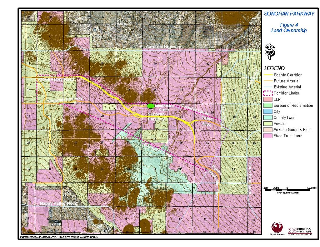
2 INTRODUCTION The purpose of the study is to determine a traffic efficient, environmentally sensitive alignment and define right of way needed to construct Sonoran Parkway and portions of Dove Valley Road, Tatum Boulevard, and Black Mountain Parkway. A stakeholder meeting was conducted during the initial phase of the Sonoran Parkway Corridor Study in July Attendees included representatives from the Maricopa County Flood Control District, State Land Department, Desert View and North Gateway Village Planning Committees, City of Phoenix Street Transportation Department, civil, geotechnical, structural, environmental, wildlife and recreation subconsultants. After developing goals and reviewing the information gathered during Phase 1 of the study, the attendees were split into teams and asked to propose their own alignments, which were later shortlisted into five alignment alternatives. North Alignment The alignment crosses Cave Creek Wash at the northern most point of any of the alternatives. It is north of the existing mining operation and is the favored crossing point of the Maricopa County Flood Control District. South Alignment The alignment travels south of the existing mining operation through the Cave Buttes Recreational Area. Cliff Alignment The alignment crosses Cave Creek Wash at a vertical 30-foot high cliff on the east bank. This alignment is at the northern edge of the mining operation. Center Alignment The alignment travels through the center of the existing mining operation. Split Alignment The alignment has two one-way roadways one mile apart traveling north and south of the mining area. Following the identification of the five alternatives, the alignments were presented at the following stakeholder meetings. Desert View Village Planning Committee, September 10, 2002, Paradise Community Center Public Meeting Dry Run, September 12, 2002, City Hall North Gateway Village Planning Committee, September 12, 2002, Deer Valley Community Center TEOC Meeting, September 19, 2002, City Hall Public Meeting, September 19, 2002, Pinnacle Peak High School Sonoran Preserve Committee, September 23, 2002, City Hall Surface Transportation Advisory Committee, October 3, 2002, City Hall Steering Committee, October 29, 2002, City Hall The north alignment was the clear preferred alternative chosen by the stakeholders. The north alignment was modified to provide direct connections to Tatum Boulevard, Black Mountain Parkway, and Dynamite Boulevard. The interpretive center will be located closer
3 to the western bank of Apache Wash. Figure 2 illustrates the modified north alignment. Figure 3 displays the proposed limits of the future Sonoran Preserve, and Figures 4 shows the land ownership in the area. The modified north alignment was presented at the following committee and stakeholder meetings: Steering Committee Meeting, March 25 th, 2003, Phoenix City Hall Sonoran Preserve Committee, May 19 th, 2003, Phoenix City Hall Surface Transportation Advisory Committee, June 5 th, 2003, Phoenix City Hall Desert View Village Planning Committee, June 13 th, 2003, Paradise Valley Community Center Public Meeting, June 10 th, 2003, Paradise Valley Community Center North Gateway Village Planning Committee, June 12 th, 2003 Phoenix Parks and Recreation Board, June 19 th, 2003 Input from the committees and stakeholders were used in determining the final alignment for Sonoran Parkway.

4

5

6
7
8 HYDRAULIC EVALUATION A preliminary evaluation to approximate the size and number of drainage crossings along the proposed roadway alignments was performed utilizing information from previous studies, Federal Emergency Management Agency (FEMA) Flood Insurance Studies (FIS), aerial mapping and USGS 7.5-minute quadrangle maps. Drainage crossings were located along each roadway alignment and structures were sized based upon several different criteria. Drainage Structures Drainage structure types and sizes were initially established to accommodate the 100-year peak discharge estimated at each drainage crossing. However, other criteria were also considered in the ultimate selection and sizing of each structure, including: Potential use for pedestrian, equestrian, or wildlife trails; The extent of floodplains, floodways and/or lateral erosion hazard zones; The amount of cover or fill at a drainage crossing; Existing drainage structures along the same watercourse. floodplain/floodways, erosion hazard zones or by the proposed vertical alignment of the roadway. Drainage Crossing Peak Discharge Estimates Peak discharges were established by either adopting values from previous drainage studies or by using techniques developed in the Desert View Arterial Street Drainage Structure Analysis (Desert View ASDSA, JE Fuller, August 2001). Drainage areas were delineated using aerial mapping, and USGS 7.5-minute quadrangle maps. The delineated areas are preliminary and do not account for numerous and complicated flow splits evident in the natural watershed areas. At a few drainage crossings, the drainage areas extended beyond the available data or information was not available from previous studies. In these instances, the culvert types and sizes were based upon existing culverts along the same watercourse or by engineering judgment. For small flows suitable for pipe culverts, a 36 pipe was the only size considered. For larger flows, only reinforced concrete box culverts with a minimum height of 4 ft. were proposed. At watercourses such as Apache Wash or Cave Creek Wash, bridges are proposed with the bridge lengths estimated based upon
9 TRAFFIC EVALUATION & RECOMMENDATION An evaluation was performed to determine roadway and intersection configurations needed to adequately serve predicted City of Phoenix general plan build out traffic volumes. The capacity of arterial roadway facilities is based on the ability of arterial intersections to accommodate peak hour volumes. Therefore, the capacity of Sonoran Parkway will be directly related to the intersection capacities of Sonoran Parkway with Dove Valley Road, and Tatum Boulevard. Build-out daily and peak hour turning movement volumes are presented in Figure 5. Based on the provided information, assumptions and findings presented in the full report, the following conclusions were reached: Sonoran Parkway West of Dove Valley Road will be a City of Phoenix cross section A (six lane divided shown in Figure 8). Dove Valley Road will be a City of Phoenix cross section Z (four lane divided shown in Figure 7) given the following: Design speed of 60 mph with a posted speed of 50 mph. Very limited access in terms of driveways, cross streets and frequency of signalized intersections (1/2 mile spacing recommended). Sonoran Parkway and Dove Valley Road Intersection will connect Sonoran Parkway and Dove Valley Road from the west to the Sonoran Parkway scenic corridor to the east. An interchange is necessary since an at-grade intersection will not satisfy the traffic demand in the area. A simple fly-over is considered the best option. A concept of the proposed flyover is illustrated on Figures 5 & 6. Sonoran Parkway Scenic Corridor will use a City of Phoenix cross section Z (six lane divided shown in Figure 8) given the following: Design speed at 65 mph with a posted speed of 55 mph No access allowed between Dove Valley Road and Tatum Boulevard Sonoran Parkway and Tatum Boulevard intersection will connect the Sonoran Parkway scenic corridor to Tatum Boulevard and Black Mountain Parkway. An interchange is necessary since an at-grade intersection will not satisfy the traffic demand in the area. A simple fly-over is considered the best option. A concept of the proposed flyover is illustrated on Figure 5 & 6. Tatum Boulevard will be a City of Phoenix cross section CM (four lane divided shown in Figure 7) provided that the roadway has very limited access (1/2 mile spacing recommended) with a design speed of 60 mph and posted speed of 50 mph.
10

11
12
13
14 UTILITIES All utilities will be present in the area because of urban areas on either side of the project. However, some utilities may use the Sonoran Parkway Corridor as a connection point between the Black Canyon Highway corridor, and the Northeast Phoenix area. Specifically: APS plans to have a 69kV line on either Carefree Highway, or Sonoran Parkway, but not both. It will likely be underground next to Sonoran Parkway in 2 5 conduits. APS forecasts the need for this line in 2010 or 2011 depending on demand. City of Phoenix water will have a 78 transmission line on the west reducing to a 66 line on the east, plus a distribution main. The preferred location is under the pavement. The City of Phoenix will also have sewer lines running in the area, and it is unlikely they will be continuous through the preserve. Currently, Southwest Gas plans on using the North Valley Parkway Corridor to service the Sonoran Foothills (west end of Sonoran Parkway) area. They do not yet know if it will be necessary to have facilities running through the preserve. Cox is still waiting to see how the area develops. They have service on both sides of the preserve, and will wait and see if connectivity is needed. If they do ever install facilities, it will likely be fiber optics requiring 2-4 way 2 conduits that can be placed in with APS s facilities. AT&T has no current plans but will reassess in the future. Qwest has not finalized any plans as yet but future facilities would be underground if required. The utility companies stressed that the need for their services are market driven, and specific plans for facilities won t be known until more is known about how the area will develop. However, those utilities that do choose to locate within the sonoran parkway corridor will place their facilities underground.
15 GEOTECHNICAL EVALUATION The purpose of the geotechnical study was to research the geologic conditions in the proposed Sonoran Parkway study corridor through review of available literature and field reconnaissance, and to provide a preliminary assessment of the geotechnical issues associated with these conditions. The tasks performed included field exploration, mapping, limited soil sampling for classification purposes, review of selected geologic maps and aerial photographs, soil surveys, and preparation of this report. Some of the younger deposits exposed in the natural drainages are prone to erosion. Some of these same materials may experience occasional perching of groundwater after significant rainfall events. Preliminary plans call for net filling over the roadway profile; therefore, identification of suitable borrow sources will be an important consideration for the project. The geotechnical study indicated the presence of five relatively distinct geologic groupings, each with different engineering characteristics: Relatively young Holocene age deposits associated with active and abandoned stream channels and flood-prone areas. Late Pleistocene age alluvial fan and terrace deposits. Middle Pleistocene age alluvial fan and terrace deposits. Early Pleistocene age alluvial fan and conglomerate deposits. Bedrock of varying age and composition. To varying degrees, the alluvial deposits exhibit potential for volume change upon wetting (i.e., shrink/swell or hydrocollapse). Many of these deposits are expected to be very coarse and/or caliche-cemented, which will affect their suitability for re-use as fill materials and their excavation characteristics.
16 ENVIRONMENTAL OVERVIEW The study area lies in the Basin and Range Physiographic Province of Arizona. More specifically, it is situated in a relatively level area between the Union Hills to the south and a smaller chain of hills to the north within the Sonoran Desertscrub Biotic Community. Portions of the study area have been previously disturbed by off-road vehicle travel and cattle grazing; however, the majority of the study area is relatively undisturbed open desert. The lack of development within the study area provides for unrestricted wildlife movement, as well as connectivity among diverse habitat types used for foraging, cover, and reproduction. Trees are not confined to washes and occur between washes and on hillsides, and the area is rich in vegetation and wildlife native to the local desert. Suitable habitat for the federally listed endangered cactus ferruginous pygmyowl and suitable foraging habitat for the federally listed endangered lesser longnosed bat is present throughout the study area. In addition, three Arizona Game and Fish Department Wildlife Species of Concern in Arizona, the Arizona toad, Sonoran desert tortoise, and Townsend s big-eared bat, could also potentially occur. Two 100-year floodplains are present and are associated with Cave Creek and Apache Wash, and U.S. Army Corps of Engineers jurisdictional "waters of the U.S.", including Cave Creek, Apache Wash, Sonoran Wash, and numerous small washes, dissect the study area. Sensitive noise receivers include the developing residential area at the western end of the study area and potential future development on other private lands. The Cave Buttes Recreation Area is present in the southcentral part of the study area. No known hazardous materials concerns exist in the study area beyond underground storage tanks and a hazardous waste handler located in the developed area along Cave Creek Road at the eastern edge of the study area. There is a large mining operation in Cave Creek and other smaller mining disturbances in the study area. An estimated 30 percent of the study area has been previously surveyed for cultural resources. Seventeen archaeological surveys have been conducted within the study area, and 40 sites have been identified (36 prehistoric, four historic). The previously conducted archaeological surveys were performed for a variety of projects including waterline easements, commercial and residential development, flood control, geotechnical testing, and underground utilities. Areas surveyed (and cultural sites recorded) are concentrated around Cave Creek and Apache Wash, with one large surveyed area located in the residential development in the western part of the study area. A part of the National Register of Historic Places-listed Cave
17 Creek Dam Archaeological District is located in the south-central part of the study area. The preferred (north) alignment appears to have the lowest number of environmental impacts of the five alternatives. The north alignment avoids concerns raised from the other alternatives, including: Avoids cliff habitat on Cave Creek Avoids Cave Buttes Recreational Area Avoids large open pit mining operation on Cave Creek Does not cross National Register of Historic Places The only concern that is raised by the north alignment, over the cliff, and center alignments is the curvilinear nature will require more ground disturbance.
18 AESTHETICS, WILDLIFE, AND RECREATION The incorporation of the future Sonoran Parkway into the study area has included the analysis and evaluation of numerous aesthetic design elements. They have been evaluated in their ability to maintain the integrity of the existing desert environment by minimizing the area of disturbance. These elements include: Roadway Alignment Transportation Routing Vistas and View Analysis Slopes Retaining wall and natural material alternatives Re-vegetation Structure Aesthetic Treatments Incorporation of Wildlife and Human trails Sonoran Preserve Edge Treatment Street Lighting Scenic Overlay Roadway Alignment Throughout the development of the corridor alternatives, the landscape architects and transportation engineers have taken curvilinear alignments into consideration when responding to the natural terrain and drainage patterns on the site. The impact of each alignment was evaluated to identify conflicts with natural attributes, and to minimize the area of disturbance to the native desert floor. Transportation Routing Vistas and View Analysis Key features of the property were identified and proposed alignments were evaluated for their ability to capitalize on views of the site s attributes and the scenic vistas. Viewsheds, from the preserve areas to the roadway was evaluated and adjustments were made to minimize the visual intrusion of the future roadway. Slopes The roadway corridor alternatives were evaluated for their impact to adjacent hillsides and slopes. The designers worked closely with the City of Phoenix Parks and Recreation Department staff to develop alignments that would abut existing and future preserve land to serve as a protection buffer. During this process care has been taken to minimize intrusion into the adjacent hillside slopes and to maintain drainage and wildlife corridor patterns. Where cutting of slopes will be necessary, revegetation and aesthetic treatments will be developed for reclamation of the natural hillside slope. Fill slopes will be warped to leave an irregular edge in order to simulate and blend into the terrain of the adjacent existing slopes. Retaining wall and natural material alternatives Where cutting of slopes and hillsides will be required the utilization of natural materials and aesthetic treatments will be employed. Utilization of native stone and boulders incorporated with textured gunite faux stone will be utilized to minimize the appearance of change to the natural terrain and hillsides. staining materials will be utilized to blend the new materials into undisturbed environment. Natural planting pockets will be incorporated into the retaining devices to blend the density of the new vegetation into the natural plant density found in the terrain. Figure 9 illustrates the utilization of
19 natural materials and aesthetic treatments. Re-vegetation Prior to the development of the roadway engineering plans, specific plant material zones should be identified adjacent to the approved corridor route. Plant material selections for each section of roadway will be developed to be utilized in the re-vegetation and development of planting pockets from station to station. Zones for required erosion control re-vegetation, will be evaluated and identified. Plant material will be identified for the incorporation into drainage ways and underpasses. Figure 11 displays the urban and scenic cross sections, with conceptual revegetation. Structure Aesthetic Treatments Aesthetic treatments have been developed for three different types of structures. These include Primary (bridges and overpasses), Secondary (fluted archways and large box culverts) and Tertiary (piping and small box culverts). Figure 10 illustrates primary and secondary crossings, while Figure 11 illustrates tertiary crossings. Alternatives have been developed for the aesthetic treatment of all three types of structures utilizing native materials and a natural color palette. appropriate size structures have been incorporated into the roadway design as not to impede the passage of users or drainage. Coordination of the required human and wildlife usage with the flow requirements of the drainage ways has been done to minimize cost where shared usage can occur. Figure 12 displays conceptual trails, and trailheads in the Sonoran Preserve. Sonoran Preserve Edge Treatment The landscape architects have worked closely with the city staff to develop the roadway corridor to complement the existing Sonoran Preserve Master Edge Plan. Public access points, an interpretive center, regional access points, and a buffer Paseo concept will be incorporated into the buffer edge treatment of the final corridor alignment selected for the parkway. Street Lighting In the preserve area, street lighting will only be provided at intersections, flyovers, and merge/diverge areas. Scenic Overlay The City of Phoenix can place a scenic overlay on the roadway corridors. It will act as zoning and will be the City s method of controlling development along the roadways. Incorporation of Wildlife and Human trails Working closely with the staff from the city s Parks and Recreation Department and the environmental planners the existing human and wildlife pathways and drainage corridors have been identified. The intersection of these paths and drainage ways with the corridor has been identified and

20
21

22

23
24 STRUCTURES OVERVIEW The Sonoran Parkway crosses the Apache Wash on a 0.60% grade. The length of bridge required at this site to pass the 100-yr flood is approximately 860 feet westbound and 850 feet eastbound. The structure depth will be limited to 8 feet to allow freeboard over the predicted water surface of The alternatives for this site include the following: span cast-in-place post-tensioned box girder bridge; for aesthetics the bridge arch could be curved. span precast I-girder bridge with a cast-in-place deck. Sonoran Parkway also crosses Mesquite Tank Wash and Cave Creek Wash. For these sites precast I-girders or cast-in-place concrete box girders will be appropriate options. The box girders lend themselves to better aesthetics. At Mesquite Tank Wash, the span lengths will be 280 feet eastbound and 440 feet westbound. The alternatives for this site include: Eastbound: a two span bridge with 140 foot spans. Westbound: two spans of 220 feet or a three span bridge with 147 foot spans. the appearance of this 1/4 mile long bridge. Dove Valley Road will cross over the Sonoran Parkway as a flyover requiring walls and a 230 foot long bridge structure. Two bridge options can be considered for this site: 2 span precast girder or cast-inplace post-tensioned box girder bridge with spans of 115 feet each and a structure depth of 5 feet; this option also includes 850 feet of wall on each side. 4 span precast girder or cast-inplace box girder bridge with spans of 100 feet on a matching skew with the Parkway; this option reduces the wall to 680 feet on each side. The final bridge location to be discussed is the Tatum Boulevard Connection Flyover. This bridge is on a 4.75 degree curve with a length required of 400 feet. Because of the curve, a two span posttensioned box girder on a curve alignment is the best option. The span lengths would be 200 feet each with a structure depth of 8 feet. Walls will also be required at this site (1050 feet on each side of the approaches). At the Cave Creek Wash a major bridge is required. The span length as proposed to cross the floodplain is 1520 feet westbound and 1435 feet eastbound. Post-tensioned box girders will require the fewest columns feet). Precast girders would require 11 spans of feet each. Careful consideration should be given to
25 PUBLIC MEETING As part of the public participatory process, a second public meeting was held on Tuesday, June 10 th, 2003 at the Paradise Valley Community Center. Notices were sent to the local newspapers, and mailers were sent to an array of people in the community. The meeting was a come and go, open format. A self-running PowerPoint presentation gave an overview of the project at the entrance. Inside the meeting, the public was free to look through the approximately twelve display boards that presented the original alignment alternatives, the preferred north alternative, land ownership, the Sonoran Preserve limits, plan and profile of the most current design, and renderings of the flyovers, the primary and secondary crossings, and tertiary crossings. Approximately 70 people attended the meeting.
Zoning Ordinance Chapter 10
 CHAPTER 10 - WASHES SECTION 10.0 GENERAL: A. The purpose of this Ordinance is to establish standards for development in or near Major and Minor Washes as defined in Appendix A Glossary of Terms and Definitions
Santa Cruz River Master Plan. Presented to the Arizona Floodplain Management Association Spring Conference June 8-10, 2011
 Santa Cruz River Master Plan Presented to the Arizona Floodplain Management Association Spring Conference June 8-10, 2011 Introduction Who is FICO? 2 Project Team Kimley-Horn and Associates, Inc. River
River Corridor Overlay Zone (RCOZ) Article 5
 Article 5") River Corridor Overlay Zone (RCOZ) Article 5 The site is in one of two designated districts. The first is the CBD (central business district) River District, which recognizes the urban character and unique
River Corridor Overlay Zone (RCOZ) Article 5 The site is in one of two designated districts. The first is the CBD (central business district) River District, which recognizes the urban character and unique
III. PROJECT DESCRIPTION
 III. PROJECT DESCRIPTION A. PROJECT LOCATION Regional Setting The project site is located in the southeast quadrant of the City of Chico in Butte County, California and is comprised of four parcels totaling
City of Waco Stormwater Management Regulations
 1.0 Applicability: City of Waco Stormwater Management Regulations These regulations apply to all development within the limits of the City of Waco as well as to any subdivisions within the extra territorial
City of Phoenix Street Transportation Department East Sonoran Parkway Alignment (ESPA) Committee Committee Recommendation April 2006
 Committee Committee Recommendation April 2006") SONORAN PARKWAY BACKGROUND City of Phoenix Street Transportation Department Important east-west alignment for congested northeast Phoenix Alignment on Street Classification map since 1987 Originally shown
SONORAN PARKWAY BACKGROUND City of Phoenix Street Transportation Department Important east-west alignment for congested northeast Phoenix Alignment on Street Classification map since 1987 Originally shown
Appendix E Preliminary Location Hydraulic Study
 Appendix E Prepared for: State of Alaska Department of Transportation and Public Facilities Prepared by: HDR Alaska, Inc. 2525 C Street, Suite 305 Anchorage, Alaska 99503 February 2014 This page intentionally
MOA Project # Campbell Airstrip Road Upgrade Mile 0.3 to 0.7
 II. Existing Conditions A. Area Context The north end of Campbell Airstrip Road begins at Tudor Road and extends south into Far North Bicentennial Park (FNBP). It leads to at least six popular trailheads
THREE-STEP DESIGN PROCESS FOR OPEN SPACE SUBDIVISIONS
 00216106.DOC NMA/RRK 1/30/14 THREE-STEP DESIGN PROCESS FOR OPEN SPACE SUBDIVISIONS Open space subdivisions, sometimes called cluster developments, maintain a significant portion of a development site in
NORTHEAST RIVER CROSSING FUNCTIONAL PLANNING STUDY
 WELCOME Northeast River Crossing Functional Planning Study Phase 2 Public Meeting 4 to 8 PM Informal drop-in format and discussion tables Meeting Purpose Introduce the Northeast River Crossing Functional
AESTHETIC APPEARANCE. Design Guidelines for Grade-Separated Pedestrian, Cyclist and Equestrian Structures
 III. AESTHETIC APPEARANCE The aesthetic qualities of a grade-separated structure are as important as the specific design criteria. For example, a structure may be constructed to the exact criteria set
Your town s subdivision or land use ordinance standards should reference the following street standards, for example:
 Your town s subdivision or land use ordinance standards should reference the following street standards, for example: Streets shall be designed to move traffic safely and in a way that minimizes environmental
Irvington to Kino 138 kv Transmission Line Project April 2018
 EXHIBIT H: EXISTING PLANS To the extent applicant is able to determine, state the existing plans of the state, local government and private entities for other developments at or in the vicinity of the
M E M O R A N D U M July 27, 2018
 Item #7 M E M O R A N D U M July 27, 2018 To: 2035 Corridor Planning Committee From: Kenneth Baker, Sr. Director of Planning and Development Services Subject: Item #7 Overview Michael Drive Purpose: Review
HAZARD MITIGATION GOALS AND OBJECTIVES
 SEWRPC Community Assistance Planning Report No. 282, 2nd Edition CITY OF MILWAUKEE ALL HAZARDS MITIGATION PLAN UPDATE Chapter IV HAZARD MITIGATION GOALS AND OBJECTIVES [NOTE: Throughout this plan update
SENSITIVE LANDS OVERLAY
 SENSITIVE LANDS OVERLAY Chapter 22 Sensitive Lands Overlay 22.1 PURPOSE 22.2 APPLICATION AND ANALYSIS REQUIREMENTS 22.3 SENSITIVE LAND REGULATIONS 22.4 ADMINISTRATIVE PROVISIONS 22.5 DESIGN STANDARDS 22.6
Lower Don River West Remedial Flood Protection Project TABLE OF CONTENTS. Page. Executive Summary
 TABLE OF CONTENTS Page Executive Summary 1.0 INTRODUCTION...1-1 1.1 Purpose of the Undertaking...1-1 1.2 Study Area Description...1-1 1.3 Description of the Undertaking...1-1 1.4 Rationale for the Undertaking...1-2
PARK CITY MUNICIPAL CODE TABLE OF CONTENTS TITLE 15 LAND MANAGEMENT CODE - CHAPTER 2.21
 PARK CITY MUNICIPAL CODE TABLE OF CONTENTS TITLE 15 LAND MANAGEMENT CODE - CHAPTER 2.21 TITLE 15 - LAND MANAGEMENT CODE CHAPTER 2.21 - SENSITIVE LAND OVERLAY ZONE (SLO) REGULATIONS 15-2.21-1. PURPOSE...1
Level 1 Downstream Analysis
 Level 1 Downstream Analysis Newcastle Way Apartments Newcastle, Washington King County April 14, 2014 Revised July 10, 2014 Prepared by: Dean A. Furr, P.E. Reviewed by: Donald Scarberry, P.E. Coffman Engineering,
4.1 AESTHETICS AND VISUAL QUALITY
 SCOPE AND METHODOLOGY 4.1 AESTHETICS AND VISUAL QUALITY This section evaluates the potential impacts to aesthetics and visual quality. Aesthetics refers to visual resources and the quality of what can
Glenn Highway MP DSR. Landscape Narrative
 Glenn Highway MP 34-42 DSR Landscape Narrative Project Landscape Goals The Glenn Highway MP 34-42 Project extends through a variety of landscape types typical to the Matanuska-Susitna Valley. In general,
Mitchell Ranch South MPUD Application for Master Planned Unit Development Approval Project Narrative. Introduction
 Mitchell Ranch South MPUD Application for Master Planned Unit Development Approval Project Narrative Introduction Mitchell Ranch South is a proposed single family (detached) residential development on
Chapter 5: Natural Resources and Environment
 NATURAL RESOURCES AND ENVIRONMENT 5-1 5 Chapter 5: Natural Resources and Environment BACKGROUND AND INTENT Urban expansion represents the greatest risk for the future degradation of existing natural areas,
Highway Alignment and Route Location Survey
 CHAPTER 2 Highway Route Surveys and Location Introduction To determine the geometric features of road design, the following surveys must be conducted after the necessity of the road is decided. Type of
WASHINGTON COUNTY OREGON
 WASHINGTON COUNTY OREGON LONG RANGE PLANNING DIVISION North Bethany Subarea Stream Corridors: Existing Regulations In Oregon, there is a distinct difference between the land use rules that apply in rural
NAPA COUNTY PUBLIC WORKS Standards & Specifications
 Roadway Design & Construction Manual (Table of Contents) 1. Chapter 1: General Provisions 1.1 Short Title 1.2 Jurisdiction 1.3 Purpose and Effect 1.4 Enactment Authority 1.5 Amendment and Revisions 1.6
3. VISION AND GOALS. Vision Statement. Goals, Objectives and Policies
 Vision Statement Queen Creek s interconnected network of parks, trails, open spaces and recreation opportunities provide safe and diverse activities and programs that sustain its unique, small town, equestrian
OVERMOUNTAIN VICTORY TRAIL BURKE CALDELL CORRIDOR FEASIBLITY STUDY REQUEST FOR QUALIFICATIONS CALDWELL COUNTY PATHWAYS
 OVERMOUNTAIN VICTORY TRAIL BURKE CALDELL CORRIDOR FEASIBLITY STUDY REQUEST FOR QUALIFICATIONS CALDWELL COUNTY PATHWAYS Caldwell County Pathways along with our co-partners City of Lenoir, Town of Gamewell,
Vaughan Metropolitan Centre (VMC) Black Creek Renewal CLASS ENVIRONMENTAL ASSESSMENT
 Black Creek Renewal CLASS ENVIRONMENTAL ASSESSMENT") PUBLIC INFORMATION CENTRE Vaughan Metropolitan Centre (VMC) Black Creek Renewal Wednesday, May 10, 2017 6:00 p.m. to 8:00 p.m. Add photo Project Management, Environmental Assessment, Stormwater Management
PUBLIC INFORMATION CENTRE Vaughan Metropolitan Centre (VMC) Black Creek Renewal Wednesday, May 10, 2017 6:00 p.m. to 8:00 p.m. Add photo Project Management, Environmental Assessment, Stormwater Management
Hunt Highway CELESTE PEMBERTON, CFM, CPM PINAL COUNTY CARLOS SANCHEZ SORIA, PE T.Y. LIN INTERNATIONAL
 Hunt Highway CELESTE PEMBERTON, CFM, CPM PINAL COUNTY CARLOS SANCHEZ SORIA, PE T.Y. LIN INTERNATIONAL Agenda Design Concept Report Phase 1 Phase 2 Phase 3 Phase 4 Phase 5 Questions Design Concept Report
2011 ASLA Design Awards
 2011 ASLA Design Awards Interstate 70 Mountain Corridor Aesthetic Guidance Honor Award Design Workshop, Aspen / THK Associates, Inc. / CH2MHill Planning and Urban Design Project Title: Interstate70 Mountain
7.0 SOCIAL, ECONOMIC, AND ENVIRONMENTAL ISSUES
 7.0 SOCIAL, ECONOMIC, AND ENVIRONMENTAL ISSUES The following list of social, economic, and environmental issues have been identified based on a preliminary inventory of resources in the project area, an
Overall Map. Chicago. St. Louis. Summit. Joliet. Dwight. Pontiac. Bloomington-Normal Lincoln. Springfield. Carlinville. Alton EXPERIENCE IT YOURSELF.
 Overall Map Summit Chicago Bloomington-Normal Lincoln New Station Planned New Station Planned Dwight Pontiac Joliet Pedestrian overpass and second platform planned Higher speed service began in this section
2011 ASLA Design Awards. Coyote Gulch Honor Award and Land Stewardship Designation Valerian LLC. Environmental Restoration and Reclamation
 2011 ASLA Design Awards Honor Award and Land Stewardship Designation Valerian LLC Environmental Restoration and Reclamation Project Name: Category : Project Location: 5 2011 Environmental Restoration and
Chain Bridge Road Sidewalk Improvements Citizen Council Work Session
 Chain Bridge Road Sidewalk Improvements Citizen Council Work Session May 10, 2016 Project Location 2 Project Objectives Provide a continuous pedestrian facility (sidewalk) connection from Downtown City
COLLIER BOULEVARD (CR 951) CORRIDOR
 CORRIDOR") Project(s) Goals Improve Traffic Circulation, Capacity & Safety Focus on Safety During Design & Construction Address Public Concerns Design an Aesthetically Pleasing Project Limit Environmental Impacts
Project(s) Goals Improve Traffic Circulation, Capacity & Safety Focus on Safety During Design & Construction Address Public Concerns Design an Aesthetically Pleasing Project Limit Environmental Impacts
When planning stormwater management facilities, the following principles shall be applied where possible.
 2.0 Principles When planning stormwater management facilities, the following principles shall be applied where possible. 2.0.1 Drainage is a regional phenomenon that does not respect the boundaries between
SECTION 4(f) DE MINIMIS DOCUMENTATION
 DE MINIMIS DOCUMENTATION") SECTION 4(f) DE MINIMIS DOCUMENTATION Illinois Route 60/83 IL 176 to the intersection of IL 60 (Townline Road) Lake County P-91-084-07 Mundelein Park and Recreation District Project Limit SECTION 4(f)
SECTION 4(f) DE MINIMIS DOCUMENTATION Illinois Route 60/83 IL 176 to the intersection of IL 60 (Townline Road) Lake County P-91-084-07 Mundelein Park and Recreation District Project Limit SECTION 4(f)
Holmberg & Howe, Land Surveyors and Civil Engineers Zoning District: R-35
 Development Impact Statement Name of Project: Red Tail Drive Acreage: 13.5 Acres± Type of Project: Residential Subdivision Owner: 96 East Street Development, LLC Location: rear of 112 East Street Parcel
Exhibit A. 8:9 Scuffletown Rural Conservation District
 Exhibit A 8:9 Scuffletown Rural Conservation District 8:9.1 Intent and Purpose The Scuffletown Rural Conservation (SRC) District is intended to provide for residential development that supports the development
Saranac River Trail Greenway C O N D I T I O N S R E P O R T
 Saranac River Trail Greenway C O N D I T I O N S R E P O R T City of Plattsburgh Clinton County, NY For: Clinton County Final Issued: March 22, 2017 This document was prepared for the New York State Department
I. DESCRIPTION OF PROPOSED ACTION... 1 A. General Description... 1 B. Historical Resume and Project Status... 2 C. Cost Estimates...
 PROJECT COMMITMENTS SUMMARY... S-1 1. Type of Action... S-1 2. Description of Action... S-1 3. Summary of Purpose and Need... S-1 4. Alternatives Considered... S-2 5. NCDOT Alternatives Carried Forward...
STREAM BUFFERS
 88-415 STREAM BUFFERS 88-415-01 PURPOSE In the Kansas City region and throughout the nation, vegetated stream buffers have been clearly shown to protect stream stability and related infrastructure, improve
Play areas overlooking climbing hill. School & playgrounds overlooking pond bottom ballfields. Project experience while at Loris and Associates, Inc.
 City of Thornton Parks & Open Space Cherrywood Park Thornton, CO Architect: Design Concepts Construction of this seven-acre City park, located adjacent to Adams Twelve Five Star Prairie Hills Elementary
ROAD CONSTRUCTION. 36 June 2014 ROADS&BRIDGES
 ROAD CONSTRUCTION 36 June 2014 ROADS&BRIDGES Young is full of life Recent expansion completes continuous, multilane arterial By Donald Hammack, P.E. Contributing Author The Florida Department of Transportation
CHAPTER 10 AESTHETICS
 CHAPTER 10 AESTHETICS CHAPTER 10 AESTHETICS This section identifies and evaluates key visual resources in the project area to determine the degree of visual impact that would be attributable to the project.
MEMORANDUM. September 10, 2018
 September 10, 2018 MEMORANDUM TO: Chad Bird, City of Decorah FROM: Larry Weber and Dan Gilles, Iowa Flood Center, IIHR Hydroscience & Engineering COPY TO: Dana Werner, St. Paul District Corps of Engineers,
ADOPTED CAPITAL IMPROVEMENT PROGRAM BUDGET ARROYO PROJECTS
 ADOPTED CAPITAL IMPROVEMENT PROGRAM BUDGET ARROYO PROJECTS HAHAMONGNA FY 212-216 Capital Improvement Program Priority Description Total Estimated Costs Appropriated Through FY 211 Adopted FY 212 FY 213
Recreational Pathway Crossing of Richmond Street Municipal Class Environmental Assessment. Public Information Centre #2 April 22, 2015
 Recreational Pathway Crossing of Richmond Street Municipal Class Environmental Assessment Public Information Centre #2 April 22, 2015 1. Study Process PHASE 1 PHASE 2 PHASE 3 PHASE 1 : Problem/Opportunity
Welcome to the Sellwood Bridge Project Pre-Construction Open House
 Welcome to the Sellwood Bridge Project Pre-Construction Open House 5:30 7:30 p.m. Please sign in here Information stations and project staff are located throughout the room. Goals for Tonight s Meeting
Chapter 3 Site Planning and Low Impact Development
 CHAPTER 3 Site Planning and Low Impact Development Chapter 3 Site Planning and Low Impact Development 3.0 Introduction The City of Charleston requires that major residential, large commercial (>1 acre),
17.18 SENSITIVE AREAS
 17.18 SENSITIVE AREAS 17.18.010 Purpose...1 17.18.020 Definitions...1 17.18.030 Review Process...1 17.18.040 Sensitive Areas Analysis...2 17.18.050 Standards and Development Plan...3 17.18.060 Geotechnical
(BRIDGE NO. 36C-0223)
") City of Palo Alto Newell Road Bridge Replacement (BRIDGE NO. 36C-0223) TYPE SELECTION REPORT DRAFT November 2012 City of Palo Alto Newell Road Bridge Replacement (BRIDGE NO. 36C-0223) TYPE SELECTION REPORT
City of Palo Alto Newell Road Bridge Replacement (BRIDGE NO. 36C-0223) TYPE SELECTION REPORT DRAFT November 2012 City of Palo Alto Newell Road Bridge Replacement (BRIDGE NO. 36C-0223) TYPE SELECTION REPORT
Lake Hazel/Gowen Relocation Alignment Study Report
 Lake Hazel/Gowen Relocation Prepared for 3775 Adams Street Garden City, Idaho 83714 And City of Boise 150 North Capitol Blvd. Boise, Idaho 83702 Prepared by Parametrix 7761 W. Riverside Dr. Suite 201 Boise,
Stormwater Regulations & Considerations Morse Study Area. Pam Fortun, P.E. CFM Senior Stormwater Treatment Engineer Engineering Services Division
 Stormwater Regulations & Considerations Morse Study Area Pam Fortun, P.E. CFM Senior Stormwater Treatment Engineer Engineering Services Division Stormwater Regulations Development Considerations Floodplain
Transportation Systems and Utility Infrastructure
 77 Audience Local and regional units of government, Landowners and developers, Community and citizen organizations, and Transportation/utility planners and engineers. Overview Transportation systems and
SECTION 5: REACH RECOMMENDATIONS/MAPS
 SECTION 5: REACH RECOMMENDATIONS/MAPS This section describes areas of concern and provides specific recommendations for each project reach. Locations of stormwater drains were from GIS coverage supplied
STREAM BANK STABILIZATION THORPS MORTIMER RECREATION AREA Grandfather Ranger District SITE LOCATION & DRAINAGE AREA
 STREAM BANK STABILIZATION THORPS CREEK @ MORTIMER RECREATION AREA SITE LOCATION & DRAINAGE AREA SITE LOCATION Drainage Area = 1.14 sq. miles STREAM BANK STABILIZATION THORPS CREEK @ MORTIMER RECREATION
Spring Creek Canyon. A Master Plan, Management Plan and Implementation Effort. Balancing the Demands on a Nationally Significant Resource
 A Master Plan, Management Plan and Implementation Effort Balancing the Demands on a Nationally Significant Resource 2010 PPA Conference - Lancaster Background Spring Creek is an internationally renowned
AMENDMENT NO. 30 TO THE OFFICIAL PLAN OF THE TOWN OF MILTON
 AMENDMENT NO. 30 TO THE OFFICIAL PLAN OF THE TOWN OF MILTON Subject: Boyne Survey Secondary Plan and Related Official Plan Amendments The following text and schedules constitute Amendment No. 30 to the
VALLEY COUNTY MINIMUM STANDARDS FOR PRIVATE ROAD DESIGN AND CONSTRUCTION
 MINIMUM STANDARDS FOR PRIVATE ROAD DESIGN AND CONSTRUCTION Adopted November 28, 2005 TABLE OF CONTENTS DEFINITION OF TERMS...II I. DESIGN CRITERIA... 1 A. GENERAL DESIGN CRITERIA... 1 B. ROADWAY CLASSIFICATION...
Welcome. Northern Segment of Hwy 100 I-90 to South of Madison Street Meeting Goals:
 Welcome Northern Segment of Hwy 100 I-90 to South of Madison Street Meeting Goals: - Review Environmental Assessment - Share Preferred Alternative -Receive Public Comments 2003 EA Preferred Alternative
Ten Mile Creek Planning Area
 PLANNING AREA POLICIES TEN MILE CREEK Ten Mile Creek Planning Area Location and Context The Ten Mile Creek Planning Area ( Ten Mile Creek area ) is located south of the current Boise AOCI, generally south
The Illinois Department of Transportation and Lake County Division of Transportation. Route 173, including the Millburn Bypass
 The Illinois Department of Transportation and Lake County Division of Transportation welcome you to this Public Hearing for U.S. Route 45 from Illinois Route 132 to Illinois Route 173, including the Millburn
WELCOME TO OPEN HOUSE TWO November 28, 2018
 Langstaff Road Weston Road to Highway 7 Class Environmental Assessment Study WELCOME TO OPEN HOUSE TWO November 28, 2018 Please sign in and join our mailing list Study Overview York Region is conducting
Otay Regional Trail Alignment Study. Public Workshop March 14 th, 2017 from 5:30-8 p.m.
 Public Workshop March 14 th, 2017 from 5:30-8 p.m. Purpose of the Study A multi-agency planning effort to create a coordinated and sustainable trail system that enhances recreation and provides trail connections
Lower Meramec Multi-Jurisdictional Floodplain Management Plan Public Involvement (Results of Early Public Engagement) 27 June 2018
 27 June 2018") Lower Meramec Multi-Jurisdictional Floodplain Management Plan Public Involvement (Results of Early Public Engagement) 27 June 2018 Public Involvement Summary: The planning process includes opportunities
Lower Meramec Multi-Jurisdictional Floodplain Management Plan Public Involvement (Results of Early Public Engagement) 27 June 2018 Public Involvement Summary: The planning process includes opportunities
C. WATER. 1. Surface Water Runoff. See Section C.3, Flood Hazard/Mudflow Hazard, page Ground Water
 C. WATER 1. Surface Water Runoff See Section C.3, Flood Hazard/Mudflow Hazard, page 67. 2. Ground Water Determined not significant by the October 1984 and January 1999 Initial Studies conducted by the
DESIGN CRITERIA PACKAGE
 RFQ: 17-C-00003 DESIGN-BUILD SERVICES FOR THE DESIGN CRITERIA PACKAGE PREPARED BY: JAMES E. JACKSON, JR. AIA CITY ARCHITECT CONTRACT ADMINISTRATION DEPARTMENT and INTERFLOW ENGINEERING, L.L.C DESIGN CRITERIA
Highway 427 Industrial Secondary Plan Area 47 Schedule C Class Environmental Assessment For Arterial Roadways
 Welcome to Pubic Information Centre #1 Highway 427 Industrial Secondary Plan Area 47 Schedule C Class Environmental Assessment For Arterial Roadways Welcome to Open House # 1 Tonight, we invite you to.
Applicant Name Phone / Fax / Address City State Zip Code . Property Owner Phone / Fax / Address City State Zip Code
 Master Development Plan Application Community Development Department City of Redmond 411 SW 9 th Street Redmond, Oregon 97756 541-923-7721 541-548-0706 FAX Master Development Plan Fee $38,862.52 File Number
PUBLIC MEETING NO. 4 OCTOBER 29, 2013
 PUBLIC MEETING NO. 4 OCTOBER 29, 2013 Arizona Canal Multi-use Path Public Process Current Design Process Public Meeting #1 - December 6, 2012 Public Meeting #2 - May 1, 2013 Public Meeting #3 September
WELCOME! 8 8:30 6: TH STREET IMPROVEMENTS. Open House. Presentation & Q&A
 WELCOME! 168 TH STREET IMPROVEMENTS 6:30 Open House 7 8 Presentation & Q&A 8 8:30 Open House WELCOME Todd Pfitzer City of Omaha Engineer Bob Stubbe City of Omaha Public Works Director Jon Meyer Project
Institutional Master Plan The Arnold Arboretum of Harvard University
 Institutional Master Plan The Arnold Arboretum of Harvard University Submitted to: Boston Redevelopment Authority One City Hall Square Boston, MA 02201 Submitted by: The Arnold Arboretum of Harvard University
INFRASTRUCTURE EXISTING INFRASTRUCTURE A. Circulation B. Signals C. Drainage D. Utilities
 7.01. EXISTING INFRASTRUCTURE A. Circulation B. Signals C. Drainage D. Utilities 7.02. PROPOSED INFRASTRUCTURE A. Overall Concept B. Circulation C. Signals D. Drainage 7.03. INFRASTRUCTURE MAP A. Key Infrastructure
Daniels Park Master Plan
 Daniels Park Master Plan Prepared for: Douglas County & The City and County of Denver October, 2007 EXHIBIT A Contents Daniels Park Overview 2 Project History & Goals 2-3 Regional Context Map 4 Park Zone
Riparian Buffer on the Bushkill Creek. Policies
 Riparian Buffer on the Bushkill Creek Riparian buffers provide numerous benefits to landowners and the community by protecting groundwater recharge areas, providing flood control, providing stormwater
Lincoln 270. City of Lincoln. Stormwater Management Plan. April 2, 2013
 Lincoln 270 City of Lincoln Stormwater Management Plan April 2, 2013 # 2005.48 Prepared By: Civil Engineering Solutions, Inc. 590 E Street Lincoln, Ca 95648 (916) 645 5700 1.0 Background: The project site
CLACKAMAS COUNTY ZONING AND DEVELOPMENT ORDINANCE
 704 RIVER AND STREAM CONSERVATION AREA (RSCA) 704.01 PURPOSE Section 704 is adopted to: A. Maintain the integrity of the rivers and streams in the County by minimizing erosion, promoting bank stability,
METROPOLITAN COUNCIL 390 North Robert Street, St. Paul, MN Phone (651) ; TDD (651)
 ; TDD (651)") DATE: December 20, 2011 METROPOLITAN COUNCIL 390 North Robert Street, St. Paul, MN 55101 Phone (651) 602-1000; TDD (651) 291-0904 TO: Metropolitan Parks and Open Space Commission FROM: Tori Dupre, Senior
DATE: December 20, 2011 METROPOLITAN COUNCIL 390 North Robert Street, St. Paul, MN 55101 Phone (651) 602-1000; TDD (651) 291-0904 TO: Metropolitan Parks and Open Space Commission FROM: Tori Dupre, Senior
SH 199 Corridor Master Plan. Community Meeting No. 2 May 31, 2017
 Community Meeting No. 2 May 31, 2017 Transportation Projects On or Near SH 199 SH 199 from 0.3 miles south of FM 1886 to south end of Lake Worth bridge Construct freeway mainlanes and frontage roads 10-Year
The following principles guide the development of goals and strategies to protect and promote these amenities:
 OPEN SPACE/PARKS/TRAILS/RECREATION GOALS/STRATEGIES Cherry Hills Village is a living environment that offers low density development, open areas, public scenic vistas, public trails and public parks. This
Master Plan Objectives and Policies
 Master Plan Objectives and Policies Introduction This chapter identifies the Park issues and recommended policies established by this Master Plan. The issues were identified through meetings with staff,
RESPONSES TO PUBLIC CONCERNS AND QUESTIONS
 RESPONSES TO PUBLIC CONCERNS AND QUESTIONS Stations and Summary Questions for Public Meeting #2 June 23, 2015 General Questions / Concerns: 1. Is there any way this development can raise revenue for the
PREPARED FOR: PLATTEVIEW ROAD CORRIDOR STUDY EXECUTIVE SUMMARY
 PREPARED FOR: PLATTEVIEW ROAD CORRIDOR STUDY EXECUTIVE SUMMARY SEPTEMBER 2016 Introduction The Platteview Road Corridor Study was led by the Metropolitan Area Planning Agency (MAPA) with assistance from
Downtown Denver Morrison. Located 30 minutes from downtown Denver behind the hogback
 Downtown Denver Morrison Located 30 minutes from downtown Denver behind the hogback Founded in 1874 as a passageway gold mines to the west. Morrison is the gateway to the Bear Creek Canyon. Surrounded
Better Cycling. The City will update the cycling master plan (London ON Bikes) based on the approved BRT network.
 based on the approved BRT network.") Better Cycling Dedicated bike facilities will be constructed along BRT corridors where space is available. Nearby bike routes will also be upgraded to ensure a complete network is available for cyclists.
Better Cycling Dedicated bike facilities will be constructed along BRT corridors where space is available. Nearby bike routes will also be upgraded to ensure a complete network is available for cyclists.
Request for Statement of Interest in Implementation of the Roosevelt Road Redevelopment Plan
 425 Hillside Avenue Request for Statement of Interest in Implementation of the Roosevelt Road Redevelopment Plan I. INTRODUCTION The is seeking the services of a qualified consulting firm to prepare plans
5. LOW IMPACT DEVELOPMENT DESIGN STANDARDS
 5. LOW IMPACT DEVELOPMENT DESIGN STANDARDS Low Impact Development (LID) requires a shift in stormwater management away from conveying runoff to a small number of downstream points through hydraulically
Major Subdivision Sketch Plan Checklist
 This checklist provides specific requirements that are apart of the Sketch process. The entire process is described by the Huntersville Subdivision Review Process which details all the submittal and resubmittal
PRELIMINARY DRAINAGE REPORT LATHAM 200 MMSCFD GAS PROCESSING PLANT
 PRELIMINARY DRAINAGE REPORT LATHAM 200 MMSCFD GAS PROCESSING PLANT LOTS B, RECORDED EXEMPTION 1211-2-1, RECX13-0096 LOCATED IN THE NORTH 1/2 OF SECTION 2, TOWNSHIP 3 NORTH, RANGE 66 WEST, 6 TH PRINCIPAL
INDEX EXECUTIVE SUMMARY...1 BASIC INFORMATION AND PROCEDURES...3 EXISTING CONDITIONS EXISTING UTILITIES
 INDEX EXECUTIVE SUMMARY...1 INTRODUCTION...2 BASIC INFORMATION AND PROCEDURES...3 EXISTING CONDITIONS... 4-5 EXISTING UTILITIES... 6-7 MEDIAN BREAKS AND TURN LANE STORAGE REQUIREMENTS...8 PRELIMINARY DESIGN
ARTICLE IV: DEVELOPMENT STANDARDS 404 MASTER PLANNING
 IV 13 404 MASTER PLANNING Master Planning through the Site Analysis (Master Planning Site Analysis) or Planned Development (Master Planning Planned Development) is provided to encourage development which
Town of Peru Comprehensive Plan Executive Summary
 Town of Peru Comprehensive Plan Executive Communities that plan grow by choice, not by chance. A plan makes growth thoughtful, understandable, and predictable. A plan shows that a community is managing
Coffee Creek Park Development Low Impact Development (LID)
") Coffee Creek Park Development Low Impact Development (LID) City of Duluth, St. Louis County, MN Presented By: Christopher J. Rousseau, P.E. February 27, 2008 Developer / Owner Information Trinity Development
Coffee Creek Park Development Low Impact Development (LID) City of Duluth, St. Louis County, MN Presented By: Christopher J. Rousseau, P.E. February 27, 2008 Developer / Owner Information Trinity Development
Chapter 5: Recreation
 Chapter 5: Recreation Introduction and Setting Recreational opportunities within Nevada County are varied, ranging from public parks with intensively used active recreational facilities, to vast tracts
3.10 LAND USE SETTING PROJECT SITE EXISTING LAND USE DESIGNATIONS AND ZONING. General Plan Land Use Designations.
 This section of the Draft EIR addresses the existing land uses on and adjacent to the project site and discusses the potential impacts of the proposed project on existing land uses. Key issues addressed
The transportation system in a community is an
 7 TRANSPORTATION The transportation system in a community is an important factor contributing to the quality of life of the residents. Without a sound transportation system to bring both goods and patrons
Section 11 Grading and Drainage Standards
 Section 11 Grading and Drainage Standards 11.1 INTRODUCTION The proper grading, conveyance, storage and release of storm water is critical to maintain the integrity of the Property. Drainage facilities,
1.0 Circulation Element
 5/9/18 1.0 Circulation Element 1.1 Introduction As growth and development occur in Apache County, enhancements to its circulation system will be necessary. With time, more roads will be paved and air and