Minot City Council -Special Meeting- Friday, July 21, :00 PM Minot City Council Chambers- City Hall
|
|
|
- Karen Powell
- 5 years ago
- Views:
Transcription

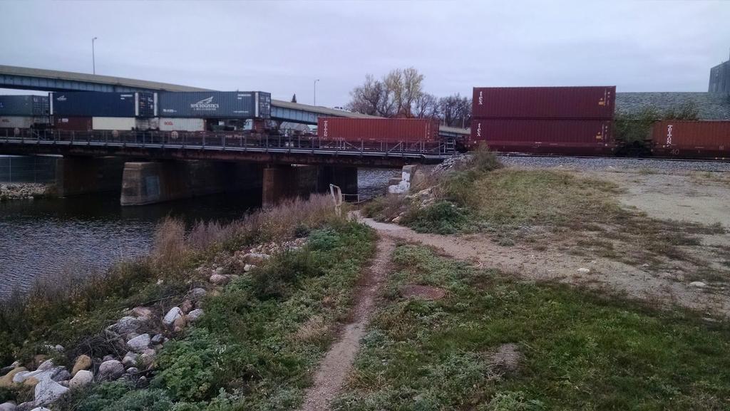
1 Minot City Council -Special Meeting- Friday, July 21, :00 PM Minot City Council Chambers- City Hall You are hereby notified pursuant to the authority vested in me as City Manager of the City of Minot, North Dakota, under Section 2-27 of the City of Minot Code of Ordinances, that I am calling a special meeting of the Minot City Council to be held in the City Council Chambers in City Hall, Minot, North Dakota, on Friday, July 21, 2017 at 12:00 pm for the purpose of discussing amendments to the Mouse River Enhanced Flood Protection Plan (MREFPP). Tom Barry, City Manager ROLL CALL PLEDGE OF ALLEGIANCE PRESENTATION OF REPRESENTATIVE LOUSER'S FLOOD INFORMATION MAPPING SYSTEM REQUEST TO THE WARD COUNTY COMMISSION PHASE 1 CHANGES/PHASE 5 DESIGN GUIDANCE Phase 5 of of the MREFPP extends from the East termination point of Phase 1 across the BNSF tracks into the Ben's Tavern neighborhood. If approved, this direction would improve and replace the existing pathway under the railroad which has fallen into a state disrepair and provide wet-side access to the project and maintain pedestrian infrastructure currently used by residents. Motion: to direct Phase 5 designs to include a pedestrian opening to the wet-side of the MREFPP near 3rd St. NE, an easement from BNSF Railroad for a shareduse path under the BNSF tracks, and improvement of the path to ADA and BNSF standards. Documents: MINOT CITY COUNCIL - PHASE 5 - PROJECT GUIDANCE.PDF 5. PHASE 1 WEST-END DESIGN EVALUATION Phase 1 of of the MREFPP extends from just West of the Broadway Bridge to just East of the 3rd Street Bridge. Current design includes pedestrian access to the wet-side of the project area at a proposed park located at the SE corner of Broadway and 4th Ave. NW. The pedestrian opening connects to a shared-use path that extends East towards the Victoria and Anne Street Bridges. This motion would direct project engineers to evaluate the feasibility of continuing the path West, under the Broadway Bridge toward an eventual connection point at and possibly under 4th Ave NW. Motion: to request the SRJB evaluate the cost and viability of continuing the wetside shared-use path from the Broadway Park entrance westward under the Broadway Bridge to provide pedestrian access to 4th Avenue and points beyond. Documents:
2 MINOT CITY COUNCIL - PHASE 1 WEST-END DESIGN EVALUATION.PDF 6. PHASE 1- WET-SIDE SHARED USE PATH EASTWARD CONTINUATION Phase 1 of the MREFPP extends from just West of the Broadway Bridge to just East of the 3rd Street Bridge. Current design includes a west-side shared use path that runs East from the Broadway access point providing access to the Victoria and Anne Street Bridges. This motion would continue construction of the shared use path eastward from the Anne Street Bridge to the termination point of Phase 1 where it would later be tied in with future construction phases. Motion: to request the SRJB authorize a design addendum to Phase 1 of the Mouse River Enhanced Flood Protection Plan for the purposes of continuing the wet-side shared-use path eastward to the termination point of Phase 1 construction. Documents: MINOT CITY COUNCIL-PHASE 1-EAST END SHARED USE PATH.PDF 7. PHASE 1: ANNE STREET BRIDGE OPENING Phase 1 of of the MREFPP extends from just West of the Broadway Bridge to just East of the 3rd Street Bridge. Current design includes pedestrian access to the wet-side of the project area at a proposed park located at the SE corner of Broadway and 4th Ave. NW. The pedestrian opening as designed requires 56' lineal feet of removable flood protection infrastructure in three separate but adjoining openings. The opening sizes are 16', 24', and 16' respectively. Phase 1 is currently 100% designed; it is expected that approval of the final bid package will be presented to City Council at the August 2017 meeting. Motion: to request the SRJB authorize a design addendum to Phase 1 of the Mouse River Enhanced Flood Protection Plan (MREFPP) for the purposes of adding an 8 pedestrian opening in the flood wall that provides direct access to the Anne Street Bridge. To accommodate operation and maintenance concerns, the Broadway Access flanking openings would be reduced from 16 to 8 each. Documents: MINOT CITY COUNCIL - PHASE 1 - ANNE STREET BRIDGE OPENING.PDF 8. CONSIDERATION OF A RESOLUTION OF SUPPORT FOR THE MAGIC CITY WATERWAY CONCEPT This resolution has been developed as a solution to the City's meanders of the Mouse River. It will not bind the City to future action or spending, it will only serve as guidance for staff and SRJB officials as they shepherd the MREFPP project through the feasibility study process to ensure the U.S.A.C.E. is aware that the City of Minot supports attempts to mitigate damages (dead loops) caused by the existing federal flood protection project. Documents: MAGIC-CITY-WATERWAY-RESOLUTION.PDF 9. ADJOURNMENT

3 Phase 1 Changes/Phase 5 Design Guidance Motion: to direct Phase 5 designs to include a pedestrian opening to the wet-side of the MREFPP near 3rd St. NE, an easement from BNSF Railroad for a shared-use path under the BNSF tracks, and improvement of the path to ADA and BNSF standards. Background: Phase 5 of of the MREFPP extends from the East termination point of Phase 1 across the BNSF tracks into the Ben's Tavern neighborhood. If approved, this direction would improve and replace the existing pathway under the railroad which has fallen into a state disrepair and provide wet-side access to the project and maintain pedestrian infrastructure currently used by residents. SRJB/Minot Considerations : The Souris River Joint Board is the project sponsor for the basin-wide Mouse River Enhanced Flood Protection Project. The City of Minot has appropriated 50% of 1-cent of sales tax toward funding the local cost share portion of the project. Within the Joint Powers Agreement between the City of Minot and the SRJB, the City retains the right to shape project design features within the city limits. Funding: Cost estimates for these changes are not yet available. It is possible this improvement would be viewed as a betterment by the State Water Commission which may limit the state s participation in cost sharing. Image Source Link
4

5 Phase 1 West-End Design Evaluation Motion: to request the SRJB evaluate the cost and viability of continuing the wet-side shared-use path from the Broadway Park entrance westward under the Broadway Bridge to provide pedestrian access to 4th Avenue and points beyond. Background: Phase 1 of of the MREFPP extends from just West of the Broadway Bridge to just East of the 3rd Street Bridge. Current design includes pedestrian access to the wet-side of the project area at a proposed park located at the SE corner of Broadway and 4th Ave. NW. The pedestrian opening connects to a shared-use path that extends East towards the Victoria and Anne Street Bridges. This motion would direct project engineers to evaluate the feasibility of continuing the path West, under the Broadway Bridge toward an eventual connection point at and possibly under 4th Ave. NW. SRJB/Minot Considerations: The Souris River Joint Board is the project sponsor for the basin-wide Mouse Rier Enhanced Flood Protection Project. The City of Minot has appropriated 50% of 1-cent of sales tax toward funding the local cost share portion of the project. Within the Joint Powers Agreement between the City of Minot and the SRJB, the City retains the right to shape project design features within city limits. Funding: Cost estimates for these changes are not yet available. It is possible this improvement would be viewed as a betterment by the State Water Commission which may limit the state s participation in cost sharing. Image Source Link

6 Current design configuration for Broadway Access point and shared-use path to the east.
7 Phase 1 - Wet-side Shared-Use Path Eastward Continuation Motion: to request the SRJB authorize a design addendum to Phase 1 of the Mouse River Enhanced Flood Protection Plan for the purposes of continuing the wet-side shared-use path eastward to the termination point of Phase 1 construction. Background: Phase 1 of of the MREFPP extends from just West of the Broadway Bridge to just East of the 3rd Street Bridge. Current design includes a west-side shared use path that runs East from the Broadway access point providing access to the Victoria and Anne Street Bridges. This motion would continue construction of the shared use path eastward from the Anne Street Bridge to the termination point of Phase 1 where it would later be tied in with future construction phases. SRJB/Minot Considerations: The Souris River Joint Board is the project sponsor for the basin-wide Mouse River Enhanced Flood Protection Project. The City of Minot has appropriated 50% of 1-cent of sales tax toward funding the local cost share portion of the project. Within the Joint Powers Agreement between the City of Minot and the SRJB, the City retains the right to shape project design features within city limits. Funding: Cost estimates for these changes are not yet available. It is possible this improvement would be viewed as a betterment by the State Water Commission which may limit the state s participation in cost sharing. Image Source Link
8 Phase 1: Anne Street Bridge Opening Motion: to request the SRJB authorize a design addendum to Phase 1 of the Mouse River Enhanced Flood Protection Plan (MREFPP) for the purposes of adding an 8 pedestrian opening in the flood wall that provides direct access to the Anne Street Bridge. To accommodate operation and maintenance concerns, the Broadway Access flanking openings would be reduced from 16 to 8 each. Background: Phase 1 of of the MREFPP extends from just West of the Broadway Bridge to just East of the 3rd Street Bridge. Current design includes pedestrian access to the wet-side of the project area at a proposed park located at the SE corner of Broadway and 4th Ave. NW. The pedestrian opening as designed requires 56' lineal feet of removable flood protection infrastructure in three separate but adjoining openings. The opening sizes are 16', 24', and 16' respectively. Phase 1 is currently 100% designed; it is expected that approval of the final bid packaged will be presented to City Council at the August 2017 meeting. SRJB/Minot Considerations: The Souris River Joint Board is the project sponsor for the basin-wide Mouse River Enhanced Flood Protection Project. The City of Minot has appropriated 50% of 1-cent of sales tax toward funding the local cost share portion of the project. Within the Joint Powers Agreement between the City of Minot and the SRJB, the City retains the right to shape project design features within city limits. Funding: Cost estimates for these changes are not yet available. It is possible this improvement would be viewed as a betterment by the State Water Commission which may limit the state s participation in cost sharing. Broadway Opening Size Current Design One 24' Wide x 13.5' Tall Primary Opening Two 16' Wide x 10' Tall Secondary Openings Alternate Configuration One 24' Wide x 13.5' Tall Primary Opening Two 8' Wide x 10' Tall Secondary Openings Anne Street Opening Size No Opening One 8' Wide x 16' Tall Opening # of Temporary Columns 4 2 # of Stoplogs (Approx.) # of Locations 1 2 Source: Ryan Ackerman, Project Administrator, SRJB
9 Image Source Link
10 RESOLUTION NO. A RESOLUTION OF SUPPORT FOR THE RESTORATION OF MINOT'S NATURAL MEANDERS OF THE MOUSE RIVER FOR THE PURPOSES OF COMMUNITY BETTERMENT, HABITAT RESTORATION, AND PUBLIC SAFETY WHEREAS, the meanders of the Mouse River through Minot -- known locally as 'dead loops -- are unintended consequences of Minot s existing federal flood protection project. WHEREAS, the meanders are sections of natural river channel through Minot. WHEREAS, the meanders support limited aquatic life and fish due to degraded habitat and water quality. WHEREAS, annual duckweed blooms on the river and in the meanders negatively impact perception of the Mouse River and may be reduced by restoration of natural current in the meanders. WHEREAS, section of the City of Minot Code of Ordinances prohibits boating or swimming within three hundred feet of a dam or any structure within the river which creates dangerous currents or other hazardous water conditions, effectively limiting the ability to canoe, swim, or recreate on the Mouse River. WHEREAS, with rising flood insurance costs and many citizens still recovering from the 2011 flood, it is reasonable for the City of Minot to pursue projects and concepts that may improve property values in flood-impacted neighborhoods near the river and natural meanders. WHEREAS, engineering firm Ackerman-Estvold, at the request of the City of Minot's former City Manager, developed the Magic City Waterway concept to restore the ecological and recreational quality of our natural meanders, improve our riverine habitat, and allow those recreating on the river to bypass the cofferdams safely. WHEREAS, the U.S. Army Crop of Engineers (U.S.A.C.E.) has a program and funding for ecosystem restoration projects that address unintended negative consequences of past U.S.A.C.E. infrastructure projects such as the Minot area's existing federal flood protection project. WHEREAS, as part of the Mouse River Enhanced Flood Protection Project (MREFPP) the Souris River Joint Board (SRJB) is required to mitigate project impacts to wetlands through habitat restoration programs. WHEREAS, the meanders, in conjunction with Minot s current flood protection infrastructure, serve the role of storm water detention.
11 WHEREAS, the protection of life and property are the primary purpose of Minot s ongoing flood protection efforts through the SRJB and the MREFPP. WHEREAS, it is appropriate and expected that Minot's City Council provide guidance and direction for future and potential projects within the City of Minot. NOW, THEREFORE, BE IT RESOLVED by the City of Minot, North Dakota to support restoration of Minot s natural meanders of the Mouse River though Minot for the purposes of community betterment, habitat restoration, and citizen safety. BE IT RESOLVED by the City of Minot, North Dakota that if wetland mitigation activities are required as a result of the MREFPP project activities within Minot, the City of Minot supports the SRJB s exploration of options to mitigate wetland impacts through restoration of the meanders of the Mouse River. BE IT RESOLVED by the City of Minot, North Dakota hereby supports the SRJB s pursuance of a federal or state partner in ecosystem restoration through the ongoing U.S.A.C.E. feasibility study activities. BE IT RESOLVED by the City of Minot, North Dakota that the Magic City Waterway or similar future concept is hereby adopted as a goal of the City of Minot. WHEREUPON, the motion was declared duly passed and adopted this day of July, ATTEST: Kelly Matalka, City Clerk APPROVED: Chuck Barney, Mayor
RESOLUTION NO. R Refining the route, profile and stations for the Downtown Redmond Link Extension
 RESOLUTION NO. R2018-32 Refining the route, profile and stations for the Downtown Redmond Link Extension MEETING: DATE: TYPE OF ACTION: STAFF CONTACT: Capital Committee Board PROPOSED ACTION 09/13/2018
MEETING DATE: November 12, 2013 SUBJECT: Accept Borden Road Bridge Improvement (CIP No )
") AGENDA REPORT Meeting of the San Marcos City Council MEETING DATE: November 12, 2013 SUBJECT: Accept Borden Road Bridge Improvement (CIP No. 88165) Recommendation Staff recommends the City Council adopt
AGENDA REPORT Meeting of the San Marcos City Council MEETING DATE: November 12, 2013 SUBJECT: Accept Borden Road Bridge Improvement (CIP No. 88165) Recommendation Staff recommends the City Council adopt
Council Agenda Report
 Agenda Item #5.4. Council Agenda Report SUBJECT: BRIDGE TO BEACH MULTI-USE PATHWAY PROJECT SIGNAGE, KIOSKS AND MAP DESIGN APPROVAL MEETING DATE: JUNE 21, 2012 RECOMMENDATION Staff recommends that the City
Support the implementation of Cape Coral's Comprehensive Plan. Protect and utilize the unique natural resources in the City.
 7.0 OVERVIEW - RECOMMENDATIONS Chapter 7 The preparation of the Cape Coral Parks and Recreation Master Plan spanned a period of approximately 12 months. Plan preparation included the input of a wide range
The full agenda including staff reports and supporting materials are available at City Hall.
 Date: February 28, 2018 Time: 6:00 p.m. Place: City Council Chambers 350 North Valencia Blvd. Woodlake, CA 93286 In compliance with the Americans with Disabilities Act and the California Ralph M. Brown
Chapter 5: Natural Resources and Environment
 NATURAL RESOURCES AND ENVIRONMENT 5-1 5 Chapter 5: Natural Resources and Environment BACKGROUND AND INTENT Urban expansion represents the greatest risk for the future degradation of existing natural areas,
Resolution A Resolution Approving the renaming of Willow Lawn Park to Robert W. Ramker Willow Lawn Park.
 Resolution 07-68 A Resolution Approving the renaming of Willow Lawn Park to Robert W. Ramker Willow Lawn Park. WHEREAS, years ago, Robert Ramker purchased over 100 acres on the west side of the old intersection
Urban runoff in my neighborhood (Capitol Hill) is heavy with trash and other debris.
 is heavy with trash and other debris.") South Platte River Meeting Comments & s #1 I am a huge fan of river areas and would love the Platte and surrounding waterways to improve to allow habitat for wildlife and recreation opportunities for citizens.
South Platte River Meeting Comments & s #1 I am a huge fan of river areas and would love the Platte and surrounding waterways to improve to allow habitat for wildlife and recreation opportunities for citizens.
Ashbridges Bay Erosion and Sediment Control Project
 Ashbridges Bay Erosion and Sediment Control Project Project Brief Overview Toronto and Region Conservation Authority, in partnership with the City of Toronto, intends to carry out remedial erosion control
ORDINANCE NO WHEREAS, a primary opportunity identified in the Plan is to Re-Connect the Uncompahgre River:
 ORDINANCE NO. 17 - AN ORDINANCE OF THE TOWN OF RIDGWAY, COLORADO AMENDING THE OFFICIAL ZONING MAP TO PROVIDE FOR THE UNCOMPAHGRE RIVER OVERLAY DISTRICT AND CREATING RIVER CORRIDOR DEVELOPMENT REGULATIONS.
The transportation system in a community is an
 7 TRANSPORTATION The transportation system in a community is an important factor contributing to the quality of life of the residents. Without a sound transportation system to bring both goods and patrons
DRAFT FOR COMMENT: EASTLAKE AVENUE PEDESTRIAN DISTRICT OVERLAY ORDINANCE
 DRAFT FOR COMMENT: EASTLAKE AVENUE PEDESTRIAN DISTRICT OVERLAY ORDINANCE Background: One of many actions in the 1998 Eastlake Neighborhood Plan was a proposal for an Eastlake Avenue Pedestrian District
IMPACT ON FINANCIAL AND PERSONNEL RESOURCES:
 MEMORANDUM TO: FROM: CITY COUNCIL GEOFF ENGLISH, PUBLIC WORKS DIRECTOR SUBJECT: CONSIDERATION OF ADOPTION OF RESOLUTIONS ORDERING THE PREPARATION AND FILING OF ANNUAL ENGINEER S REPORTS FOR THE PARKSIDE
FOR AGENCY MEETING OF: AGENDA ITEM NO.: URBAN RENEWAL AGENCY BOARD STEVEN POWERS, EXECUTIVE DIRECTO#
 FOR AGENCY MEETING OF: AGENDA ITEM NO.: March 14, 2016 4.2(a) TO: THROUGH: FROM: SUBJECT: URBAN RENEWAL AGENCY BOARD STEVEN POWERS, EXECUTIVE DIRECTO# KRISTIN RETHERFORD, DIRECTOR '!(/L/ URBAN DEVELOPMENT
U.S. Army Corps of Engineers, Los Angeles District Prado Basin Project Updates
 U.S. Army Corps of Engineers, Los Angeles District Prado Basin Project Updates Host: Inland Empire Utilities Agency January 19, 2017 10:00 a.m. Purpose: To provide project overviews and updates to regional
RFP DRAINAGE OUTFALL DESIGN AND PERMITTING. Mandatory Meeting for Proposers August 15, 2015
 RFP 2018-02 DRAINAGE OUTFALL DESIGN AND PERMITTING Mandatory Meeting for Proposers August 15, 2015 IMPORTANT DATES August 15 th, 2:00pm August 17 th, 5:00pm August 22 nd, 5:00pm September 5 th, 2:00pm
The Mystic River Greenway
 The Mystic River Greenway City of Medford November 30, 2006 MIT Department of Urban Studies and Planning The Mystic River Greenway A greenway is a regional network that connects: Open Space Visibility,
RESOLUTION NO , 2016 COLUMBIA TOWNSHIP, HAMILTON COUNTY, OHIO
 RESOLUTION NO. 16-17, 2016 COLUMBIA TOWNSHIP, HAMILTON COUNTY, OHIO RESOLUTION DETERMINING TO PROCEED TO LEVY A TAX IN EXCESS OF THE TEN-MILL LIMITATION WITHIN THE RIDGE FIRE DISTRICT OF COLUMBIA TOWNSHIP
PURPOSE: The purpose is to provide commercial facilities in the Vancouver and Clark County vicinity.
 US Army Corps of Engineers Seattle District Joint Public Notice Application for a Department of the Army Permit and a Washington Department of Ecology Water Quality Certification and/or Coastal Zone Management
NATURAL RESOURCES BOARD AGENDA REGULAR MEETING TUESDAY, OCTOBER 2ND, :00 P.M MAIN STREET, SEBASTIAN, FL
 1. CALL TO ORDER 2. PLEDGE OF ALLEGIANCE 3. ROLL CALL NATURAL RESOURCES BOARD AGENDA REGULAR MEETING TUESDAY, OCTOBER 2ND, 2018-6:00 P.M. 1225 MAIN STREET, SEBASTIAN, FL To improve the quality of life
Priorities. Public Communication & Transparency Website, CM Public Updates, Magic City Newsletter
 Priorities Recognition & Thanks to public servant employees Public Communication & Transparency Website, CM Public Updates, Magic City Newsletter Citizen/Customer Service Fiscal Responsibility Flood Protection
Red Fox Commercial Outline Plan
 Red Fox Commercial Outline Plan City of Cold Lake, Alberta Prepared by Durrance Projects Ltd and Ross W. Sharp & Associates Ltd October 2014 Rupert 1 Table of Contents 1. PURPOSE...3 1.1. Location...4
ADOPTION OF THE REVISED OPEN SPACE AND CONSERVATION ELEMENT OF THE GENERAL PLAN
 TO: FROM: SUBJECT: Honorable Mayor and City Council Planning Department ADOPTION OF THE REVISED OPEN SPACE AND CONSERVATION ELEMENT OF THE GENERAL PLAN RECOMMENDATION: It is recommended that the City Council:
Parks, Trails, and Open space Element
 Parks, Trails, and Open space Element Parks, Trails, and Open Space element Parks, Recreation, and Open Space are important components of the quality of life desired by the residents of Elk Grove. This
DATE: January 19, WCA Governing Board. Johnathan Perisho, Project Manager. Mark Stanley, Executive Officer
 DATE: January 19, 2016 TO: FROM: THROUGH: SUBJECT: WCA Governing Board Johnathan Perisho, Project Manager Mark Stanley, Executive Officer Item 18: Consideration of a resolution to approve contract amendment
Pittsfield Action Plan (West Branch of the Housatonic River)
") An initiative of the Massachusetts Executive Office of Energy and Environmental Affairs in partnership with the City of Pittsfield Pittsfield Action Plan (West Branch of the Housatonic River) The spring
An initiative of the Massachusetts Executive Office of Energy and Environmental Affairs in partnership with the City of Pittsfield Pittsfield Action Plan (West Branch of the Housatonic River) The spring
Parks, Trails, and Open Space Element
 P arks, Recreation, and Open Space are important components of the quality of life desired by the residents of Elk Grove. This Element of the General Plan addresses the City s goals, policies, and actions
WASHINGTON COUNTY OREGON
 WASHINGTON COUNTY OREGON LONG RANGE PLANNING DIVISION North Bethany Subarea Stream Corridors: Existing Regulations In Oregon, there is a distinct difference between the land use rules that apply in rural
EXHIBIT A CITY OF FORT WALTON BEACH, FLORIDA COASTAL MANAGEMENT & CONSERVATION
 EXHIBIT A CITY OF FORT WALTON BEACH, FLORIDA INTRODUCTION The Coastal Management and the Conservation Elements required by Chapter 9J-5.012 and 5.013, F.A.C., respectively, have been combined into one
Floodplain Management Plan 2016 Progress Report
 PREPARED FOR: Borough of Point Pleasant Beach 416 New Jersey Ave. Point Pleasant Beach, NJ 08742 (732) 892-1118 http://www.pointpleasantbeach.org/ PREPARED BY: T&M Associates 11 Tindall Road Middletown,
CITY OF STUART, FLORIDA AGENDA ITEM REQUEST CITY COMMISSION
 CITY OF STUART, FLORIDA AGENDA ITEM REQUEST CITY COMMISSION Prepared by: 7. Title of Item: Resolution No. 90-2014; Rebates for energy efficient renovation activities. (RC) Summary Explanation/Background
CITY OF ST. AUGUSTA STEARNS COUNTY MINNESOTA ORDIANCE NO AN ORDINANCE ESTABLISHING REGULATIONS FOR STORMWATER MANAGEMENT
 CITY OF ST. AUGUSTA STEARNS COUNTY MINNESOTA ORDIANCE NO. 2017-05 AN ORDINANCE ESTABLISHING REGULATIONS FOR STORMWATER MANAGEMENT In the interest of the health, safety, and welfare of its citizens, the
CONSERVATION ELEMENT GOALS, OBJECTIVES, AND POLICIES
 CONSERVATION ELEMENT GOALS, OBJECTIVES, AND POLICIES Goal 4 To conserve, manage, appropriately use and protect the natural resources of the City ensuring continued resource availability and environmental
AREA-WIDE PEDESTRIAN AND BICYCLE CIRCULATION
 OUSD LANEY CHILD CARE CENTER ART BUILDING LANEY COLLEGE BALL FIELDS PCCD OFFICES PERALTA PARK AQUATIC CENTER & ESTUARY PARK EDOFF MEMORIAL BANDSTAND SNOW PARK COURT HOUSE OAKLAND MUSEUM OAK ST AREA-WIDE
Planning Districts INTRODUCTION
 INTRODUCTION To facilitate detailed examination of development prospects for all areas of the community, Delano has been divided into 14 planning districts. The location of these planning districts is
STORM WATER UTILITY FREQUENTLY ASKED QUESTIONS
 STORM WATER UTILITY FREQUENTLY ASKED QUESTIONS In 2007, the City Council adopted Ordinance No. 1155 establishing a storm water utility in the City. No fee structure was adopted at that time. The idea of
AGENDA 07/14/11 PLANNING COMMISSION Meeting
 AGENDA 07/14/11 PLANNING COMMISSION Meeting MEETING DATE: Thursday, July 14, 2011 MEETING TIME: MEETING PLACE: VIDEO: 5:30 p.m. City Council Chambers, City Hall 350 Main Street El Segundo, California 90245-0989
Grand Rail Commercial Development Site Plan Application
 Grand Rail Commercial Development Site Plan Application April 27, 2012 Memo To: North Liberty Planning Commission From: Dean Wheatley, Planning Director Subject: Site Plan Approval Request for 725 Pacha
RECREATION AND OPEN SPACE ELEMENT GOALS, OBJECTIVES, AND POLICIES
 RECREATION AND OPEN SPACE ELEMENT GOALS, OBJECTIVES, AND POLICIES Goal 7 To provide park facilities, recreation programs, and open space resources that are safe, adequate, and accessible to all City residents,
City of Yorba Linda Memorandum
 City of Yorba Linda Memorandum Date: June 15, 2011 Date: To: From: Honorable Chairman and Members of the Parks and Recreation Commission Mike Kudron, Acting Director of Parks and Recreation SUBJECT: BACKGROUND
RESOLUTION NO
 RESOLUTION NO. 2016-16 A RESOLUTION PROVIDING FOR THE SUBMISSION TO THE QUALIFIED ELECTORS OF THE CITY OF BELLINGHAM AT AN ELECTION TO BE HELD ON NOVEMBER 8, 2016 OF A PROPOSITION AUTHORIZING THE CITY
City of Meriden Harbor Brook Flood Control Project Overview
 City of Meriden Harbor Brook Flood Control Project Overview Updated August 2013 OVERVIEW The center of Meriden, including the HUB site is the low point of the town which is ringed by basalt ridges. Running
CITY OF SAN MATEO ORDINANCE NO
 CITY OF SAN MATEO ORDINANCE NO. 2012-4 AMENDING SECTION 27.38.090, OPEN SPACE REQUIREMENTS, OF CHAPTER 27.38, CBD DISTRICTS-CENTRAL BUSINESS DISTRICT, SECTION 27.64.023, PARKING PROHIBITED ON LAWNS, FLOWERS,
CITY OF YUBA CITY STAFF REPORT
 CITY OF YUBA CITY STAFF REPORT Agenda Item 9 Date: February 19, 2013 To: From: Presentation by: Honorable Mayor & Members of the City Council Public Works Department George Musallam, Public Works Director
Intergovermental Coordination
 Intergovermental Coordination CITY OF WINTER PARK CHAPTER 8: INTERGOVERNMENTAL COORDINATION ELEMENT INTERGOVERNMENTAL COORDINATION ELEMENT GOAL 8-1: PROVIDE FOR IMPROVED INTERGOVERNMENTAL COORDINATION
Exhibit A. 8:9 Scuffletown Rural Conservation District
 Exhibit A 8:9 Scuffletown Rural Conservation District 8:9.1 Intent and Purpose The Scuffletown Rural Conservation (SRC) District is intended to provide for residential development that supports the development
The City shall enhance and improve the accessibility of parks and recreational facilities while protecting their quality. by:
 GOALS, OBJECTIVES AND POLICIES GOAL 1: To provide open space and recreation as an essential element needed for the betterment of the City s character and quality of urban life. The City shall plan for
CHAPTER 2 SUMMARY 1. PROJECT SUMMARY DATA
 CHAPTER 2 SUMMARY This is an Initial Study format used to determine, pursuant to CEQA Guidelines Section 15177, whether a project 1) is within the scope of a Master EIR (MEIR), 2) may result in additional
CONSENT CALENDAR September 27, 2005
 Office of the Executive Officer September 27, 2005 To: From: Submitted By: Subject: Honorable Chairperson and Members of the Redevelopment Agency Phil Kamlarz, Executive Officer Dan Marks, Director, Planning
RESOLUTION NO. WHEREAS, the City of Riverdale (the City ) has a planning commission and has adopted a general plan pursuant to applicable law; and
 has a planning commission and has adopted a general plan pursuant to applicable law; and") RESOLUTION NO. RESOLUTION OF THE REDEVELOPMENT AGENCY OF RIVERDALE CITY ADOPTING AN OFFICIAL PROJECT AREA PLAN FOR THE 700 WEST COMMUNITY DEVELOPMENT PROJECT AREA. WHEREAS, the Redevelopment Agency of
RESOLUTION NO. RESOLUTION OF THE REDEVELOPMENT AGENCY OF RIVERDALE CITY ADOPTING AN OFFICIAL PROJECT AREA PLAN FOR THE 700 WEST COMMUNITY DEVELOPMENT PROJECT AREA. WHEREAS, the Redevelopment Agency of
Chapter 1: General Program Information
 Chapter 1: General Program Information 1.1 Introduction The Montgomery County Stormwater Management Resolution (#03-1-5) was adopted by the County Board of Commissioners on January 22, 2003. The purpose
City of Loveland Public Information Meeting February 19, 2009
 Railroad Quiet Zones City of Loveland Public Information Meeting February 19, 2009 Railroad Quiet Zones AGENDA: 7:00-7:05 Introduction Frank Hempen (City Project Manager) 7:05-7:20 Railroad Quiet Zones
The maximum amounts shown in the Engineer s Report for each of those categories for FY 2008/09 are as follows (per house/per year):
:") Agenda Item No. August 28, 2007 TO: FROM: SUBJECT: Honorable Mayor and City Council Attention: David J. Van Kirk, City Manager Dale I. Pfeiffer, Director of Public Works RESOLUTION INITIATING PROCEEDINGS,
Agenda Item No. August 28, 2007 TO: FROM: SUBJECT: Honorable Mayor and City Council Attention: David J. Van Kirk, City Manager Dale I. Pfeiffer, Director of Public Works RESOLUTION INITIATING PROCEEDINGS,
The following principles guide the development of goals and strategies to protect and promote these amenities:
 OPEN SPACE/PARKS/TRAILS/RECREATION GOALS/STRATEGIES Cherry Hills Village is a living environment that offers low density development, open areas, public scenic vistas, public trails and public parks. This
Town of Lyons Parks Flood Recovery Planning Process. Photograph courtesy of Ed Bruder
 Town of Lyons Parks Flood Recovery Planning Process Photograph courtesy of Ed Bruder Lyons Parks and Recreation Flood Recovery Update 1. Meadow Park Phase II - Project PW20B1 Estimated Completion: Summer
MINUTES OF THE TOWN COUNCIL MEETING SEPTEMBER 1, 2016
 MINUTES OF THE TOWN COUNCIL MEETING SEPTEMBER 1, 2016 Town Council Meeting 09/20/16 Item #1 The Town Council of the Town of Los Gatos conducted a Special Meeting on Thursday, September 1, 2016, at 6:00
Mendota Heights 2040 Comprehensive Plan Draft Vers
 4 Parks and Trails The City of Mendota Heights boasts a variety of recreational and open space opportunities. Few cities can claim access to regional trails, riverside and lakeside parks, scenic bluffs
G. RECREATION AND OPEN SPACE ELEMENT. The following summarizes the Recreation and Open Space Element:
 G. RECREATION AND OPEN SPACE ELEMENT The purpose of the Element is to provide the framework and direction for a comprehensive system of public and private sites for recreation, including, but not limited
Enhance the High Line Canal Projects
 Enhance the High Line Canal Projects Joint Project Proposal for Arapahoe County Open Spaces Funding Partner Sponsors: South Suburban Park and Recreation District City of Centennial City of Littleton October
Peoria Riverfront Development (Ecosystem Restoration) Upper Mid-sized Island Critical Restoration Project (September 2011)
 Upper Mid-sized Island Critical Restoration Project (September 2011)") Peoria Riverfront Development (Ecosystem Restoration) Upper Mid-sized Island Critical Restoration Project (September 2011) Description The Corps of Engineers, Rock Island District (District) and the Illinois
Peoria Riverfront Development (Ecosystem Restoration) Upper Mid-sized Island Critical Restoration Project (September 2011) Description The Corps of Engineers, Rock Island District (District) and the Illinois
TOWN OF BEEKMAN TOWN BOARD MEETING AGENDA April 10, 2019
 TOWN OF BEEKMAN TOWN BOARD MEETING AGENDA April 10, 2019 7:00 PM Meeting called to order Pledge of Allegiance Administrative Announcement--Fire Exits TOWN BOARD MEETING Recreation Department Report Jeanne
STAFF RECOMMENDATION: Adopt the Parks and Recreation Master Plan 2013, or take other action as deemed appropriate.
 Regular 7. CITY COUNCIL AGENDA Meeting Date: 12/02/2013 TITLE: Parks and Recreation Master Plan 2013 Adoption Proposal - Dwight Curtis Responsible Staff: Dwight Curtis Backup Material: Backup material
SAN RAFAEL CITY COUNCIL AGENDA REPORT
 Agenda Item No: 7.b Meeting Date: December 4, 2017 SAN RAFAEL CITY COUNCIL AGENDA REPORT Department: Public Works/City Attorney Prepared by: Kevin McGowan, Asst. Director of Public Works Lisa Goldfien,
Preliminary Sketch Plan for Fort Hunter Park
 Preliminary Sketch Plan for Fort Hunter Park Public Presentation November 19, 2009 Dauphin County Parks and Recreation 100 Fort Hunter Road Harrisburg, PA 17110 (717) 599-5188 www.dauphinc.org THOMAS COMITTA
CHEBOYGAN COUNTY PLANNING COMMISSION
 CHEBOYGAN COUNTY PLANNING COMMISSION 870 SOUTH MAIN ST. PO BOX 70 CHEBOYGAN, MI 49721 PHONE: (231)627-8489 FAX: (231)627-3646 CHEBOYGAN COUNTY PLANNING COMMISSION MEETING & PUBLIC HEARING WEDNESDAY, NOVEMBER
A larger version of this map is located on the last page of this PDF.
 MAP Committee Input McLoughlin Area Draft Vision Map A larger version of this map is located on the last page of this PDF. 1. The map above is intended to portray a vision for the McLoughlin area. It highlights
Shoreline Master Program Town of La Conner, Washington
 Shoreline Master Program Town of La Conner, Washington Department of Ecology approval effective Adopted September 24, 2013 by Town of La Conner Ordinance No.1106 Amended May 13, 2014 by Town of La Conner
Folly Beach Planning Commission
 Folly Beach Planning Commission June 4, 2018 6:00 PM WORK SESSION 7:00 PM REGULAR MEETING ---------------------------------------------------------------------------------------------------- Commission
Joe Pool Lake Master Plan Revision Public Information Meeting May 23, 2017
 Joe Pool Lake Master Plan Revision Public Information Meeting May 23, 2017 Presented By Jason Owen Lake Manager U.S. Army Corps of Engineers Fort Worth District US Army Corps of Engineers Purpose of this
STAFF REPORT. Planning and Zoning Case 16-17FDP Staff: Mike Peterman, City Planner Date: April 25, 2016
 STAFF REPORT Planning and Zoning Case 16-17FDP Staff: Mike Peterman, City Planner Date: April 5, 016 GENERAL INFORMATION Application: P&Z Case 16-17FDP: Final Development Plan to allow the development
Longmeadow Parkway Fox River Bridge Corridor. August 6, 2015
 Longmeadow Parkway Fox River Bridge Corridor August 6, 2015 Longmeadow Parkway Bridge Corridor 5.6 miles from Huntley Road to IL 62 Unique municipal/county/state/federal partnership Links Randall Road
EAST LAKE TARPON COMMUNITY OVERLAY
 EAST LAKE TARPON COMMUNITY OVERLAY East Lake Tarpon in Pinellas County Florida physical area is defined by the boundaries of the as shown in the map below and legal description in Appendix A. VISION: East
Town of Essex Small Site Erosion Control Guide
 Town of Essex Small Site Erosion Control Guide Why do we need to protect against erosion? Water Quality: Erosion and the transport of sediment and pollutants impacts the water quality of nearby streams
Lake O the Pines Master Plan Revision Public Information Meeting April 25 & 27, 2017
 Lake O the Pines Master Plan Revision Public Information Meeting April 25 & 27, 2017 Presented By Matthew Like, Lake Manager U.S. Army Corps of Engineers Fort Worth District US Army Corps of Engineers
CITY OF CHARLOTTESVILLE, VIRGINIA CITY COUNCIL AGENDA
 CITY OF CHARLOTTESVILLE, VIRGINIA CITY COUNCIL AGENDA Agenda Date: December 16, 2013 Action Required: Adoption of Resolution Presenter: Staff Contacts: Title: James E. Tolbert, AICP, Director of NDS James
1) Providing education, access to healthy foods, and economic support for the local food system
 Providing education, access to healthy foods, and economic support for the local food system") Page 1 of x s Policy Statement Community gardens should be created, where appropriate, within designated urban agriculture areas in neighborhood parks, as well as on tax-forfeited parcels that are acquired
Page 1 of x s Policy Statement Community gardens should be created, where appropriate, within designated urban agriculture areas in neighborhood parks, as well as on tax-forfeited parcels that are acquired
Green Infrastructure The Indianapolis Greenways Connection
 Green Infrastructure The Indianapolis Greenways Connection Fewer things in the transportation industry today make better since than combining the needs for pedestrian and bike trails with the need to locate,
CITY OF SIMI VALLEY MEMORANDUM
 CITY OF SIMI VALLEY MEMORANDUM AGENDA ITEM NO. Consent (3) August 15, 2016 TO: FROM: City Council Department of Public Works SUBJECT: ADOPTION OF PLANS AND SPECIFICATIONS AND AUTHORIZATION TO SOLICIT CONSTRUCTION
DISCUSSION TOPIC: ST JOHNS RIVER & ITS TRIBUTARIES (BPII) 2030 COMPREHENSIVE PLAN POLICES AND REGULATORY FRAMEWORK
 2030 COMPREHENSIVE PLAN POLICES AND REGULATORY FRAMEWORK") DISCUSSION TOPIC: ST JOHNS RIVER & ITS TRIBUTARIES (BPII) 2030 COMPREHENSIVE PLAN POLICES AND REGULATORY FRAMEWORK St. John s River & Its Tributaries Issue Summary: The St. Johns River is an important
DISCUSSION TOPIC: ST JOHNS RIVER & ITS TRIBUTARIES (BPII) 2030 COMPREHENSIVE PLAN POLICES AND REGULATORY FRAMEWORK St. John s River & Its Tributaries Issue Summary: The St. Johns River is an important
Lewisville Lake Master Plan Revision Public Information Meeting May 2 & 4, 2017
 Lewisville Lake Master Plan Revision Public Information Meeting May 2 & 4, 2017 Presented By Rob Jordan Lake Manager U.S. Army Corps of Engineers Fort Worth District US Army Corps of Engineers Purpose
Delegation of Authorization to the Art in Public Places Advisory Board to Develop and Administer Visual Arts Projects
 CITY HALL 01 WEST PALMETTO PARK ROAD BOCA RATON, FL CITY OF PHONE (1 ) -00 (FOR HEARING IMPAIRED) TOO (1) -0 www.myboca.us Boca Raton June, 01 TO: FROM: SUBJECT: Mayor and City Council Leif J. Ahnell,
PUBLIC SERVICES ELEMENT GOALS / POLICIES / MEASURES
 PUBLIC SERVICES ELEMENT GOALS / POLICIES GOALS / POLICIES / MEASURES Authority The Public Services Element addresses provision of municipal services to City residents. The following paragraphs provide
Whitemarsh Township Greenway Plan
 Whitemarsh Township Greenway Plan Prepared for: Whitemarsh Township August 16, 2007 Table of Contents Table of Contents... i Introduction... 1 Study Area Setting... 2 Regional Setting... 2 Township Character...
STATE OF NORTH CAROLINA DECLARATION OF
 Prepared by and Return to: Orange County Parcel Identification Number(s): STATE OF NORTH CAROLINA COUNTY OF ORANGE DECLARATION OF RESTRICTIVE COVENANTS THIS DECLARATION OF RESTRICTIVE COVENANTS ( Declaration
COASTAL MANAGEMENT ELEMENT. Last amended December 6, 2016 as part of the 2016 EAR
 COASTAL MANAGEMENT ELEMENT Last amended December 6, 2016 as part of the 2016 EAR Table of Contents Objective Page 7.1 Development and redevelopment of waterfront properties...7-1 7.2 Agency coordination
WELCOME! 8 8:30 6: TH STREET IMPROVEMENTS. Open House. Presentation & Q&A
 WELCOME! 168 TH STREET IMPROVEMENTS 6:30 Open House 7 8 Presentation & Q&A 8 8:30 Open House WELCOME Todd Pfitzer City of Omaha Engineer Bob Stubbe City of Omaha Public Works Director Jon Meyer Project
The Napa River Flood Protection Project
 The Napa River Flood Protection Project Creating Flood Protection and Restoring Geomorphic and Biological Processes Jeremy Sarrow, Napa County Flood Control & Water Conservation District June 2, 2014.
An Ambitious Plan: Transforming the blighted South Platte River and surrounding environment into Denver s greatest natural resource.
 CONNECTING THE PEOPLE TO THEIR RIVER SOUTH PLATTE RIVER VISION IMPLEMENTATION PROGRAM: GRANT-FRONTIER PARK TO OVERLAND POND PARK REACH The South Platte River Vision Implementation Program (River Vision)
RESOLUTION NO. WHEREAS, the proposed Master Plan for Villa Esperanza (VE), located at 2116
, located at 2116") RESOLUTION NO. A RESOLUTION OF THE CITY COUNCIL OF THE CITY OF PASADENA APPROVING A MASTER PLAN FOR VILLA ESPERANZA WHEREAS, the proposed Master Plan for Villa Esperanza (VE), located at 2116 Villa Street
RESOLUTION NO. A RESOLUTION OF THE CITY COUNCIL OF THE CITY OF PASADENA APPROVING A MASTER PLAN FOR VILLA ESPERANZA WHEREAS, the proposed Master Plan for Villa Esperanza (VE), located at 2116 Villa Street
REPORT TO MAYOR AND COUNCIL
 REPORT TO MAYOR AND COUNCIL AGENDA ITEM NO. 5.a TO THE HONORABLE MAYOR AND COUNCIL: DATE: May 26, 2015 SUBJECT: ADOPT RESOLUTION NOS. 15-33, 15-34, 15-35, AND 15-36, CONFIRMING THE ASSESSMENT DIAGRAMS
Meeting Display Boards for Public Hearing on the Wilson Transfer Station Project held Tuesday, February 18, 2014.
 Meeting Display Boards for Public Hearing on the Wilson Transfer Station Project held Tuesday, February 18, 2014. Board 1: Welcome Welcome to the Wilson Transfer Station Project Public Hearing. The purpose
STAFF REPORT TO THE CITY COUNCIL. Conduct Public Hearing to vacate certain public right of way adjacent to Sycamore Avenue and San Pablo Avenue
 STAFF REPORT TO THE CITY COUNCIL DATE: Adjourned Regular Meeting of December 16, 2014 TO: SUBMITTED BY: SUBJECT: Mayor and Members of the City Council Holly Smyth, Planning Director Conduct Public Hearing
VILLAGE BOARD MEETING STAFF REPORT
 Meeting: Village Board Meeting Date: 05/09/2016 Agenda Item: 6b Mission Statement To provide our residents with a safe, friendly, attractive and active community by aggressively pursuing innovative ways
PRELIMINARY STAFF PLANNING REPORT TO THE WALWORTH COUNTY ZONING AGENCY X CONDITIONAL USE
 This report was prepared prior to the public hearing. This report may be supplemented or amended to reflect the review of additional information presented at the public hearing and written material submitted
EXTRACT FROM MAYOR AND COUNCIL MEETINGS PERTAINING TO FIRE HYDRANTS
 EXTRACT FROM MAYOR AND COUNCIL MEETINGS 1882-1931 PERTAINING TO FIRE HYDRANTS June 8, 1882 Committee be assigned to designate the number of hydrants required by the City and the locations of said hydrants
ORDINANCE 2009-_15_ WATER CONSERVATION POLICY
 ORDINANCE 2009-_15_ WATER CONSERVATION POLICY AN ORDINANCE OF THE CITY COUNCIL OF THE CITY OF PALM COAST, FLORIDA RELATING TO AMENDING CHAPTER 24 WATER CONSERVATION POLICY OF THE CODE OF ORDINANCES OF
ORDINANCE NO
 ATTACHMENT CC-1 ORDINANCE NO. 13-2113 AN ORDINANCE OF THE CUPERTINO CITY COUNCIL APPROVING THE REZONING OF AN APPROXIMATELY 1.1 ACRE AREA FROM PARK AND RECREATION (PR) TO PLANNED INDUSTRIAL PARK (P(MP))
RRW Stonebrook, LLC Tentative Map Findings
 RRW Stonebrook, LLC Tentative Map Findings FINDING T1: The request conforms to the Master Plan and zoning ordinances. RELATIONSHIP TO THE MASTER PLAN 1. The respective development is located within an
CITY OF SIMI VALLEY MEMORANDUM
 CITY OF SIMI VALLEY MEMORANDUM AGENDA ITEM NO. 9.1 May 18, 2016 TO: FROM: Planning Commission Department of Environmental Services SUBJECT: REVIEW OF POTENTIAL FISCAL YEAR (FY) 2016-17 CAPITAL IMPROVEMENT
CHARLES COUNTY GOVERNMENT RFP NO POPES CREEK RAIL TRAIL DESIGN
 CHARLES COUNTY GOVERNMENT Department of Fiscal and Administrative Services Purchasing Division Telephone: 301-645-0656 July 7, 2015 RFP NO. 16-02 POPES CREEK RAIL TRAIL DESIGN ADDENDUM NUMBER ONE TO: All