LOS ANGELES COUNTY METROPOLITAN TRANSPORTATION AUTHORITY (LACMTA)
|
|
|
- Helena Dalton
- 6 years ago
- Views:
Transcription
1 CE OF PREPARAT
2 LOS ANGELES COUNTY METROPOLITAN TRANSPORTATION AUTHORITY (LACMTA) NOTICE OF PREPARATION OF AN ENVIRONMENTAL IMPACT STATEMENT (E1S)lENVIRONMENTAL IMPACT REPORT (EIR) TO: AGENCIES, ORGANIZATIONS & INTERESTED PARTIES. SUBJECT: NOTICE OF PREPARATION (NOP) OF AN EISIEIR PROJECT TITLE: EASTSIDE TRANSIT CORRIDOR PHASE 2 PROJECT PROJECT LOCATION AND ENVIRONMENTAL SETTING: The Eastside Transit Corridor Phase 2 Project is located in eastern Los Angeles County and is generally bounded by Pomona Boulevard and State Route 60 (SR-60) Freeway to the north, Peck Road and Painter Avenue to the east, Olympic and Washington Boulevards to the south, and Atlantic Boulevard to the west. The project area consists of portions of eight jurisdictions, including the cities of Commerce, Montebello, Monterey Park, Pico Rivera, Rosemead, Santa Fe Springs, South El Monte, Whittier, and portions of unincorporated Los Angeles County which include east Los Angeles and west Whittier-Los Nietos. A diverse mix of land uses are located within the project area, including single- and multi-family residences, commercial and retail uses, industrial development, parks and recreational uses including the Whittier Narrows Recreation Center, health and medical uses, educational institutions, flood control facilities, and vacant lands. The proposed Eastside Transit Corridor Phase 2 Project would connect to the eastern terminus of the Metro Gold Line Eastside Extension. In conjunction with the Metro Gold Line
3 Eastside Extension, the project would provide transit service between downtown Los Angeles and eastern Los Angeles County, to as far east as Whittier or South El Monte. Of the four alternatives identified for further consideration in the Environmental Impact Statement/Environmental Impact Report (EISIEIR), the two build alternatives propose a Light Rail Transit (LRT) system that would begin at the Metro Gold Line Eastside Extension terminus at Atlantic Boulevard and Pomona Boulevard and continue either east along the SR-60 Freeway or southeast along Garfield Avenue and Washington Boulevard. Stations plus associated parking, traction power substations (TPSS), ancillary facilities, and a maintenance yard would be part of each LRT alternative./ PROJECT INTITIATION: The Los Angeles County Metropolitan Transportation Authority (LACMTA) and the Federal Transit Administration (FTA) will prepare an EISIEIR for the Eastside Transit Corridor Phase 2 Project pursuant to the National Environmental Policy Act (NEPA) (23 U.S.C. 139) and the California Environmental Quality Act (CEQA). LACMTA is serving as the local lead agency for purposes of CEQA environmental clearance, and FTA is serving as the federal lead agency for purposes of NEPA environmental clearance. This notice shall alert interested parties to the preparation of the EISIEIR, describe the alternatives under consideration, invite public participation in the EISIEIR process, and announce the public scoping meetings. FTA and LACMTA will invite interested Federal, State, tribal, regional and local government agencies to be participating agencies under the provisions of Section 6002 of the Safe, Accountable, Flexible, Efficient Transportation Equity Act: A Legacy for Users (SAFETEA-LU).
4 PURPOSE AND NEED FOR THE PROJECT: The purpose of this project is to improve public transit service and mobility in the Eastside Transit Corridor Phase 2 project area. The project would provide the study area with improved fixed-guideway east-west transit service from the Metro Gold Line Eastside Extension (Phase 1) to cities farther east of the City of Los Angeles. Possible eastern extensions from the Metro Gold Line Phase 1 terminus at Atlantic Boulevard would include an alignment that generally continues east along State Route 60 or an alignment that continues south along Garfield Avenue, turning southeast along Washington Boulevard. The overall goal of the proposed project is to improve mobility in the Eastside Transit Corridor Phase 2 by extending the benefits of the existing Metro Gold Line and bus investments beyond the current terminus. Mobility problems and potential improvements for this corridor have been well documented in many studies that are available from LACMTAYs Records Management Department, including numerous Metro Red Line planning studies, Eastside Transit Corridor Stzrdies: Re-Evalztation Major Investment Study (2000), the Eastside Transit Corridor Phase 2 Final Alternatives Analysis Report (2009), the Eastside Transit Corridor Phase 2 Alternatives Analysis Addendztm (2009), Southern California Association of Governments (SCAG) planning studies, the Metro Rapid Demonstration Project (2000), and in the Southern California Association of Governments' Regional Transportation Plan (2008). The Eastside Transit Corridor Phase 2 is identified in the LACMTA's Long Range Plan and has been selected as one of the many transit and highway projects to receive local Measure R funding. Additional considerations supporting the project's need include: 1) the concentration of activity centers and destinations dispersed throughout the project area, such as Montebello Town Center, Monterey Park Mall, Pico Rivera Town Center, Santa Fe Springs Promenade, Uptown Whittier District, and Whittier Narrows Recreation Center, which have a high volume of 3
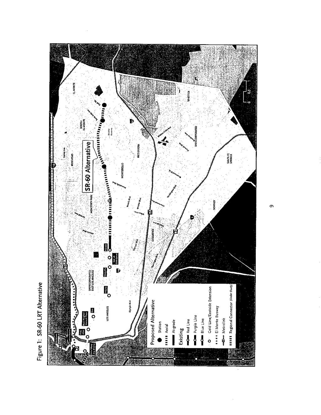
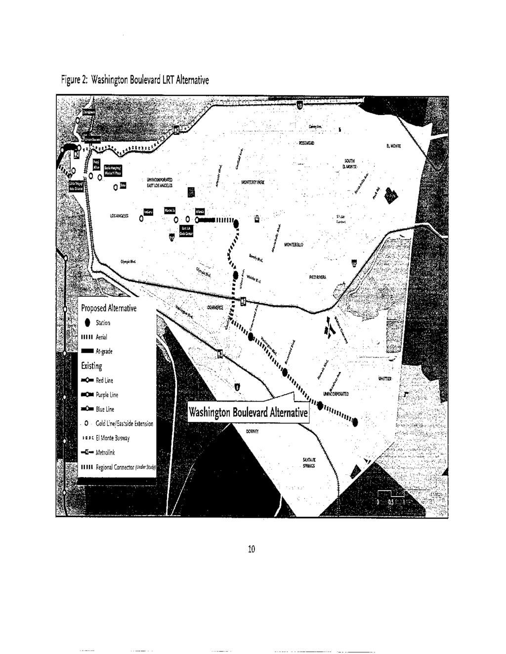
5 pedestrian activity and attract residents from within and outside of the project area; 2) over the next 20 years, the project area population is expected to grow by nearly 24%, for a total of 830,000, and employment is also expected to increase 15%, for a total of 384,000 jobs; 3) increasing traffic congestion on the highway and arterial network throughout the project area; 4) transit-supportive General Plans in the Cities of Commerce, Montebello, Monterey Park, Pico Rivera, Rosemead, Whittier, and County of Los Angeles; 5) significant transit dependent population in western and eastern portions of the project area; and 6) emerging travel demand patterns associated with a job-rich project area that has led to significant westbound congestion during the morning rush hours and corresponding eastbound congestion during the evening rush hours. ALTERNATIVES: The Eastside Transit Corridor Phase 2 Alternatives Analysis Report (2009) and further refinement documented in the Alternatives Analysis Report Addendum (2009), prepared for LACMTA, identified four alternatives for further consideration in the EISEIR. The four alternatives include: the No-Build Alternative, Transportation System Management (TSM) Alternative, SR-60 LRT Alternative, and Washington Boulevard LRT Alternative. Figures I and 2 depict the SR-60 LRT and Washington Boulevard LRT build alternatives proposed for analysis in the environmental document. No-Build Alternative: The No-Build Alternative would maintain existing transit service through the year No new transportation infrastructure would be built within the project area aside from projects currently under construction, or funded for construction and operation by 2035 by the recently approved Measure R sales tax. This alternative will include the highway and transit projects in the current Metro Long Range Transportation Plan and the 2035 Southern 4
6 California Association of Governments Regional Transportation Plan. The completion of the Metro Rapid Bus Program would be included as well as possible additional feeder bus networks to serve the region's major activity centers. Transportation System Management (TSM) Alternative: The DEIS/DEIR will evaluate transportation and environmental effects of modest improvements in the highway and transit systems beyond those in the No-Build Alternative. The TSM Alternative would include low-cost improvements to the No-Build Alternative to reduce delay and enhance mobility. The TSM Alternative would emphasize transportation system upgrades, such as intersection improvements, minor road widening, traffic engineering actions, bus route restructuring, shortened bus headways, expanded use of articulated buses, reserved bus lanes, expanded parkand-ride facilities, express and limited-stop service, signalization improvements, and timedtransfer operations. Key elements of the TSM Alternative include: providing new Pomona Freeway Express service connecting to the Metro Gold Line Eastside Extension terminus; providing new Beverly Boulevard Rapid bus service; adding service to MI0 Whittier Boulevard and M50 Washington Boulevard bus routes; upgrading M30 Garfield Avenue and M20 Montebello Boulevard bus lines; adding service to Metro 265 and 266 local buses; adding service to Foothill Transit 274; and providing new Metro 577 Express service operating along Metro Route 270. SR-60 LRT Alternative: This build alternative alignment (Figure 1) extends approximately 6.9 miles east with a street level, at-grade system from the current Metro Gold Line Eastside Extension (Phase 1) terminus at Atlantic Boulevard and Pomona Boulevard and transitions to an aerial configuration along the south edge of the SR-60 Freeway, within the
7 Caltrans and U.S. Army Corps of Engineers right-of-way, to Peck Road in South El Monte. A total of four aerial stations are proposed under this alternative with locations at SR-60 and Garfield Avenue, SR-60 and Montebello Town Center, SR-60 and Santa Anita Avenue, and SR- 60 and Peck Road. Washington Boulevard LRT Alternative: This build altcrnative alignment (Figurc 2) extends east with a street level, at-grade system from the current Metro Gold Line Eastside Extension (Phase 1) terminus at Atlantic Boulevard and Pomona Boulevard and transitions to an aerial configuration along the south edge of the SR-60 Freeway. The aerial alignment turns and continues south on Garfield Avenue, and then continues southeast along Washington Boulevard to a terminus east of Lambert Road in the City of Whittier. This alternative is approximately 9.3 miles in length, with a total of six aerial stations located at SR-60 and Garfield Avenue, Garfield Avenue and Whittier Boulevard, Washington Boulevard and Greenwood Avenue, Washington and Rosemead Boulevards, Washington and Nonvalk Boulevards, and Washington Boulevard and Lambert Road. PROBABLE ENVIRONMENTAL EFFECTS: The purpose of this EISIEIR process is to study, in a public setting, the effects of the proposed project and its alternatives on the physical, human, and natural environment. The FTA and LACMTA will evaluate all significant environmental, social, and economic impacts of the construction and operation of the proposed project. The probable impacts will be determined as a part of project scoping. Unless further screening illuminates areas of possible impact, resource areas will be limited to those uncovered during scoping. Measures to avoid, minimize, and mitigate adverse impacts will be identified and evaluated.
8 SCOPING MEETINGS: Public scoping meetings to accept comments on the scope of the EIS/EIR will be held on the following dates: Monday, February 22,2010; 6:00 to 8:00 PM at the Pio Pico Women's Center, 9214 Mines Avenue, Pico Rivera, CA. Wednesday, February 24,2010; 6:00 to 8:00 PM at the South El Monte Senior CenterDining Room, 1556 Central Avenue, South El Monte, CA. Thursday, February 25,2010; 6:00 to 8:00 PM at the Senior Center at City Park - South Wing, 115 South Taylor Avenue, Montebello, CA. Saturday, February 27,2010; 10:OO AM to 12:OO PM at the Salvation Army Santa Fe Springs - Studio 12000, East Washington Boulevard, Whittier, CA. The project's purpose and need and the description of alternatives for the proposed project will be presented at these meetings. The buildings used for the scoping meetings are accessible to persons with disabilities. Any individual who requires special assistance, such as a translator or sign language interpreter, to participate in the scoping meeting should contact Ms. Kimberly Yu, Transportation Planning Manager, LACMTA, at (213) , or yuki@,metro.net. Scoping materials will be available at the meetings and on the LACMTA website ( Paper copies of the scoping materials may also be obtained from Ms. Ann Kerman, Outreach Project Manager, LACMTA, at (213) , or kermana@metro.net. An interagency scoping meeting will be held on Thursday, February 18, 2010, at 10:OOAM at LACMTA, in the Windsor Conference Room, 15th Floor, One Gateway Plaza, Los Angeles, CA Representatives of Native American tribal governments and of
9 all Federal, State, regional and local agencies that may have an interest in any aspect of the project will be invited to be participating or cooperating agencies, as appropriate. COMMENT DUE DATE: Written comments on the scope of the EIS/EIR, including the purpose and need, the alternatives to be considered, the impacts to be evaluated, and the methodologies to be used in the evaluation, will be accepted during the comment period and should be sent to LACMTA on or before Wednesday, April 14,2010 at the address below. ADDRESSES: Comments will be accepted at the public scoping meetings or they may be sent to Ms. Kimberly Yu, Project Manager, Los Angeles County Metropolitan Transportation Authority, One Gateway Plaza, Mail Stop , Los Angeles, CA 90012, or via at The locations of the scoping meetings are provided above, under SCOPING MEETINGS. FOR FURTHER INFORMATION CONTACT: Mr. Ray Tellis, Team Leader, Los Angeles Metropolitan Office, Federal Transit Administration, 888 South Figueroa Street, Suite 1850, Los Angeles, CA 90017, phone (213) ,
10
11
Eastside Transit Corridor Phase 2 Draft Environmental Impact Statement/ Environmental Impact Report APPENDIX N
 Draft Environmental Impact Statement/ Environmental Impact Report APPENDIX N LAND USE AND DEVELOPMENT OPPORTUNITIES TECHNICAL MEMORANDUM State Clearinghouse Number: 2010011062 APPENDIX N Addendum to the
Section Regulatory Framework/Methodology. Land Use and Development
 Section 4.2 Land Use and Development This section summarizes the existing land uses and developments in the project area, and the potential impacts of the proposed alternatives on these resources. Information
Eastside Transit Corridor Phase 2 Technical Study Update Community Outreach Meeting February 2017
 Eastside Transit Corridor Phase 2 Technical Study Update Community Outreach Meeting February 2017 Purpose of Tonight s Meeting Recap of Board motion (2014) and technical study process Provide update on
Attachment D Eastside Transit Corridor Phase 2 Technical Study Route Options Screening Analysis and Community Outreach Executive Summary April 2017
 Attachment D Eastside Transit Corridor Phase 2 Technical Study Route Options Screening Analysis and Community Outreach Executive Summary April 2017 Technical Study Scope Nov 2014: Board-directed Technical
Eastside Transit Corridor Phase 2 Draft Environmental Impact Statement/ Environmental Impact Report APPENDIX Q
 Draft Environmental Impact Statement/ Environmental Impact Report APPENDIX Q VISUAL AND AESTHETIC IMPACTS TECHNICAL MEMORANDUM State Clearinghouse Number: 2010011062 Visual and Aesthetic Impacts Technical
Eastside Transit Corridor Phase 2 Draft Environmental Impact Statement/ Environmental Impact Report APPENDIX F. SECTION 4(f) EVALUATION
 EVALUATION") Draft Environmental Impact Statement/ Environmental Impact Report APPENDIX F SECTION 4(f) EVALUATION State Clearinghouse Number: 2010011062 August 2014 Prepared for Los Angeles County Metropolitan Transportation
Draft Environmental Impact Statement/ Environmental Impact Report APPENDIX F SECTION 4(f) EVALUATION State Clearinghouse Number: 2010011062 August 2014 Prepared for Los Angeles County Metropolitan Transportation
NOTICE OF PREPARATION
 NOTICE OF PREPARATION To: All Interested Parties Subject: Notice of Preparation of an Environmental Impact Report From: City of Petaluma Address: 11 English Street, Petaluma, CA 94952-2610 Contact: Heather
Right-of-Way Acquisitions and Relocations Technical Memorandum
 Right-of-Way Acquisitions and Relocations Technical Memorandum Southeast Extension Project Lincoln Station to RidgeGate Parkway Prepared for: Federal Transit Administration Prepared by: Denver Regional
Call to Artists Public Art for Los Angeles Metro Stations
 Conceptual Design for Call to Artists Public Art for Los Angeles Metro Stations Artesia Transit Center Union Station/Patsaouras Transit Plaza Los Angeles County Metropolitan Transportation Authority February
Crenshaw/LAX Transit Corridor Project
 Crenshaw/LAX Transit Corridor Project Final Environmental Impact Report/ Final Environmental Impact Statement TABLE OF CONTENTS EXECUTIVE SUMMARY August 2011 State Clearing House No. 2007091148 U.S. Department
NOTICE OF PREPARATION OF A DRAFT ENVIRONMENTAL IMPACT REPORT AND NOTICE OF PUBLIC SCOPING MEETING: VERMONT CORRIDOR PROJECT
 NOTICE OF PREPARATION OF A DRAFT ENVIRONMENTAL IMPACT REPORT AND NOTICE OF PUBLIC SCOPING MEETING: VERMONT CORRIDOR PROJECT DATE: May 4, 2017 TO: FROM: PROJECT TITLE: PROJECT ADDRESS: All Interested Agencies,
APPENDIX J SHPO COORDINATION
 Final Environmental Impact Statement/Final Environment Impact Report Appendix J SHPO Coordination APPENDIX J SHPO COORDINATION August 2011 CRENSHAW/LAX TRANSIT CORRIDOR PROJECT Final Environmental Impact
Ashland BRT Environmental Assessment: logos of CTA, CDOT, Chicago Department of Housing and Economic Development
 Ashland BRT Environmental Assessment: logos of CTA, CDOT, Chicago Department of Housing and Economic Development Overview The Chicago Transit Authority (CTA), in partnership with the Chicago Department
Whittier Greenway Trail. Est. 2009
 Whittier Greenway Trail Est. 2009 The Whittier Greenway Trail begins in the northwest corner of Whittier, near the 605 Freeway, and closely parallels Whittier Boulevard. When it reaches Painter Avenue,
Eastern Terminus TECHNICAL MEMORANDUM CENTRAL BROWARD EAST-WEST TRANSIT ANALYSIS BROWARD COUNTY, FLORIDA
 Eastern Terminus TECHNICAL MEMORANDUM CENTRAL BROWARD EAST-WEST TRANSIT ANALYSIS BROWARD COUNTY, FLORIDA FINANCIAL PROJECT ID NUMBER 411189-2-22-01 FLORIDA DEPARTMENT OF TRANSPORTATION DISTRICT 4 Prepared
Southeast Extension to RidgeGate Parkway Scoping Booklet
 Southeast Extension to RidgeGate Parkway Scoping Booklet PUBLIC SCOPING MEETING SCHEDULE Public Scoping Meeting Wednesday, November 2, 2011 6:00pm to 7:30pm City of Lone Tree Recreation Center Willow Room
METRO Gold Line BRT CBAC Meeting. August 23, 2018
 METRO Gold Line BRT CBAC Meeting August 23, 2018 1 Today s Topics Introductions Corridor Management Committee Update Public Engagement Update History of Alignment Project Scope Discussions Upcoming CBAC
1.0 PROJECT PURPOSE AND NEED
 1.0 PROJECT PURPOSE AND NEED The FasTracks Plan includes the extension of the Central Corridor from its current terminus at 30th/Downing to a connection to the East Corridor commuter rail service planned
California Environmental Quality Act (CEQA) Environmental Review Process
 Environmental Review Process") California Environmental Quality Act (CEQA) Environmental Review Process Los Angeles Union Station Forecourt and Esplanade Improvements constitute a Project Los Angeles County Metropolitan Transportation
California Environmental Quality Act (CEQA) Environmental Review Process Los Angeles Union Station Forecourt and Esplanade Improvements constitute a Project Los Angeles County Metropolitan Transportation
RESOLUTION NO. R Refining the route, profile and stations for the Downtown Redmond Link Extension
 RESOLUTION NO. R2018-32 Refining the route, profile and stations for the Downtown Redmond Link Extension MEETING: DATE: TYPE OF ACTION: STAFF CONTACT: Capital Committee Board PROPOSED ACTION 09/13/2018
2. INTRODUCTION 2.1 AUTHORITY 2.2 PURPOSE AND INTENT 2.3 SITE LOCATION
 2. INTRODUCTION 2.1 AUTHORITY The City of Gardena initiated and prepared the Artesia Corridor Specific Plan pursuant to the provisions of California Government Code, Title 7, Division 1, Chapter 3, Article
West Broadway Transit Study Initial Screening of Alternatives Memo
 West Broadway Transit Study Initial Screening of Alternatives Memo 5/22/2015 Prepared by the SRF Consulting Group Team for Table of Contents Purpose... 1 Methodology... 1 Screening... 5 Screening Criteria...
Section 4.11 Traffic and Transportation 4.11 TRAFFIC AND TRANSPORTATION
 4.11 TRAFFIC AND TRANSPORTATION The following sections summarize the evaluation of the potential traffic/transportation impacts of the San Gabriel River Corridor Master Plan. First, the analysis methodology
March 30, Keyes Van Nuys Honda Dealership Keyes Motor, Inc.
 March 30, 08 ENVIRONMENTAL CASE NO.: ENV-07-77-EIR PROJECT NAME: PROJECT APPLICANT: Keyes Van Nuys Honda Dealership Keyes Motor, Inc. PROJECT ADDRESS: 600, 6007, 605, 6053, and 6059 N. Van Nuys Boulevard;
Atlanta BeltLine Corridor Environmental Study. Scoping Meeting August 2008
 Atlanta BeltLine Corridor Environmental Study Scoping Meeting August 2008 What Will We Be Discussing Today? Study Overview - How Did We Get Here? - What Is the Study About? - Who Is Involved? - Where Is
Mavis Road Class Environmental Assessment
 Mavis Road Class Environmental Assessment Public Information Centre #2 Wednesday November 9, 2016 6:00 to 8:00 p.m. Please sign in and complete a comment sheet Review the displays on your own or join in
South Davis County COMMUNITY SPOTLIGHT
 South Davis County COMMUNITY SPOTLIGHT Davis/SLC Community Connector Bus Rapid Transit line connecting SLC & Davis County RTP Phase 1 Project Generate 3,100 average weekday riders Relieve congestion on
CITY OF ALHAMBRA DEVELOPMENT SERVICES DEPARTMENT 111 S. First Street. Alhambra, CA (626) FAX (626)
 FAX (626)") CITY OF ALHAMBRA DEVELOPMENT SERVICES DEPARTMENT 111 S. First Street. Alhambra, CA 91801 (626) 570-5030 - FAX (626) 458-4201 NOTICE OF PREPARATION TO: SUBJECT: Agencies, Organizations and Interested Parties
CITY OF ALHAMBRA DEVELOPMENT SERVICES DEPARTMENT 111 S. First Street. Alhambra, CA 91801 (626) 570-5030 - FAX (626) 458-4201 NOTICE OF PREPARATION TO: SUBJECT: Agencies, Organizations and Interested Parties
Appendix D Community Impact Assessment
 Appendix D Community Impact Assessment This page is intentionally blank. Mid-City/Exposition Light Rail Transit Project Community Impact Assessment Memorandum for the Improvements at Farmdale Avenue and
Project facts that will help me to understand the I-710 Corridor Project and DEIR/EIS
 Project facts that will help me to understand the I-710 Corridor Project and DEIR/EIS What is the I-710 Corridor Project? The Interstate 710 (I-710) Corridor Project proposes to improve I-710 from Ocean
Public Hearing April 12, Information as of April 12, 2018
 Public Hearing April 12, 2018 Meeting Agenda California Environmental Quality Arts District Act (CEQA) Project Area Overview Project Background & Description Draft Environmental Impact Report (DEIR) Next
March 29, Angels Landing Project Angels Landing Partners, LLC
 March 29, 2019 ENVIRONMENTAL CASE NO.: ENV-2018-3273-EIR PROJECT NAME: PROJECT APPLICANT: Angels Landing Project Angels Landing Partners, LLC PROJECT ADDRESS: 361 S. Hill Street (332-358 S. Olive Street,
NORTH-SOUTH CORRIDOR STUDY EXECUTIVE SUMMARY. Executive Summary
 Executive Summary Background As congestion continues to affect mobility in the region, the Ozarks Transportation Organization (OTO) is particularly concerned with traffic movement. The North-South Corridor
Route 110 Alternatives Analysis
 Route 110 Alternatives Analysis Public Meeting #1 December 15, 2014 Source: Town of Babylon Agenda Welcome/Introduction Hon. Antonio A. Martinez Deputy Supervisor, Town of Babylon Update on East Farmingdale
Archaeological Resources Supplemental Survey Technical Report
 ` Archaeological Resources Supplemental Survey Technical Report March 2012 THIS PAGE INTENTIONALLY LEFT BLANK NATIONAL ARCHAEOLOGICAL DATABASE (NADB) INFORMATION Authors Consulting Firm Nancy E. Sikes,
Project Overview. Get Involved. Public Information Meeting. Contact Information
 Get Involved VDOT representatives will review and evaluate information received as a result of this meeting. Please fill out the comment sheet provided in this brochure if you have any comments or questions.
4. ENVIRONMENTAL IMPACT ANALYSIS 7. LAND USE AND PLANNING
 4. ENVIRONMENTAL IMPACT ANALYSIS 7. LAND USE AND PLANNING 4.7.1 INTRODUCTION The following analysis discusses the consistency of the Proposed Project with the corresponding land use and zoning designations
SAN FRANCISCO MUNICIPAL TRANSPORTATION AGENCY
 THIS PRINT COVERS CALENDAR ITEM NO. : 10.3 DIVISION: Sustainable Streets BRIEF DESCRIPTION: SAN FRANCISCO MUNICIPAL TRANSPORTATION AGENCY Approving the removal of Municipal Railway bus zones at various
Notice of Preparation
 Notice of Preparation OF ENVIRONMENTAL IMPACT REPORT AND PUBLIC SCOPING MEETING August 23, 2017 REVISED AND RECIRCULATED NOTICE OF PREPARATION OF AN ENVIRONMENTAL IMPACT REPORT AND SCOPING MEETING Note:
Inglewood Transit Connector Environmental Impact Report Scoping Meeting July 26, 2018
 Inglewood Transit Connector Environmental Impact Report Scoping Meeting July 26, 2018 Tonight s Speakers and Key Staff City of Inglewood Honorable Mayor James T. Butts, Jr. Louis A. Atwell, Director, Public
WESTSIDE SUBWAY EXTENSION. Visual and Aesthetics Impacts Technical Report
 Visual and Aesthetics Impacts Technical Report August 2010 Table of Contents Table of Contents 1.0 INTRODUCTION... 1-1 2.0 PROJECT DESCRIPTION... 2-1 2.1 No Build Alternative... 2-1 2.2 TSM Alternative...
Tyvola & Archdale Transit Station Area Plan. June 5, 2008
 Tyvola & Archdale Transit Station Area Plan Second Public Meeting June 5, 2008 Presentation Outline 1. Purpose and Process 2. Station Area Overview 3. Plan Recommendations 4. Comments Received and Proposed
Draft Environmental Assessment Appendix A. SHPO Correspondence, January 19, 2017
 Draft Environmental Assessment Appendix A. SHPO Correspondence, January 19, 2017 Rosecrans/Marquardt Grade Separation Project April 2018 Federal Railroad Administration U.S. Department 1200 New Jersey
Project Facts about the I-710 Corridor Project and RDEIR/SDEIS
 Project Facts about the I-710 Corridor Project and RDEIR/SDEIS What is the I-710 Corridor Project? The Interstate 710 (I-710) Corridor Project proposes to improve I-710 from Ocean Boulevard in the City
PLANNING COMMISSION. COMMISSIONS/PUBLIC WORKSHOP Options for the Future. Introduction
 COMMISSIONS/PUBLIC WORKSHOP Options for the Future E n v i s i o n W h i t t i e r PLANNING COMMISSION Introduction This document provides background materials for board members and Commissioners attending
February 26, 2018 ENVIRONMENTAL CASE NO.: ENV EIR PROJECT NAME:
 February 26, 2018 ENVIRONMENTAL CASE NO.: ENV-2017-5091-EIR PROJECT NAME: Sunset Gower Studios Enhancement Plan PROJECT APPLICANT: Hudson Pacific Properties, Inc. PROJECT ADDRESS: 6010, 6050 and 6060 Sunset
COMMUNITY DEVELOPMENT SERVICES PLANNING AND BUILDING DEPARTMENT
 COMMUNITY DEVELOPMENT SERVICES PLANNING AND BUILDING DEPARTMENT http://www.edcgov.us/devservices/ PLACERVILLE OFFICE: 2850 Fairlane Court, Placerville, CA 95667 BUILDING (530) 621-5315 / (530) 622-1708
Transportation. Strategies for Action
 Transportation A major priority for the Overlake Neighborhood is to develop a multimodal transportation system. To achieve this system, a balance has to be found among travel, circulation and access needs;
Regional Transportation District
 NORTHEAST AREA TRANSIT EVALUATION FINAL REPORT Prepared for: Regional Transportation District Prepared by: David Evans and Associates, Inc. URS, Corporation November 2007 LIST OF FIGURES Figure 1: Northeast
Existing Transportation System 5-1
 5-1 The Jackson County transportation system is served by several modes of transportation including streets and highways, multi-modal, non-motorized, rail, and aviation. While the focus of the transportation
Gold Line Bus Rapid Transit Transit Oriented Development (BRTOD) Helmo Station Area Plan
 Helmo Station Area Plan") Appendix F Gold Line Bus Rapid Transit Transit Oriented Development (BRTOD) Helmo Station Area Plan Introduction and Purpose of the Plan The Gold Line Bus Rapid Transit facility is an eleven-mile dedicated
Appendix F Gold Line Bus Rapid Transit Transit Oriented Development (BRTOD) Helmo Station Area Plan Introduction and Purpose of the Plan The Gold Line Bus Rapid Transit facility is an eleven-mile dedicated
NOTICE OF PREPARATION
 NOTICE OF PREPARATION DATE: April 6, 2017 TO: FROM: Responsible Agencies Trustee Agencies Local and Public Agencies Interested Parties Contact: Brent Cooper, AICP, Community Development Director 4381 Broadway
Corridor Vision. 1Pursue Minnehaha-Hiawatha Community Works Project. Mission of Hennepin County Community Works Program
 1Pursue Minnehaha-Hiawatha Community Works Project Minnehaha-Hiawatha Community Works is a project within the Hennepin Community Works (HCW) program. The mission of the HCW program is to enhance how the
Eglinton West LRT Update
 Eglinton West LRT Update Community Consultation Update May 16, 2016 Background Rapid transit along Eglinton Ave between Kennedy Station and Pearson Airport was included in the Metrolinx Regional Transportation
DOWNTOWN REDMOND LINK EXTENSION SEPA Addendum to the East Link Project Final Environmental Impact Statement
 DOWNTOWN REDMOND LINK EXTENSION 2018 SEPA Addendum to the East Link Project Final Environmental Impact Statement AUGUST 2018 Downtown Redmond Link Extension SEPA Addendum to the 2011 East Link Project
CHAPTER 7: Transportation, Mobility and Circulation
 AGLE AREA COMMUNITY Plan CHAPTER 7 CHAPTER 7: Transportation, Mobility and Circulation Transportation, Mobility and Circulation The purpose of the Transportation, Mobility and Circulation Chapter is to
Notice of Preparation
 Notice of Preparation OF ENVIRONMENTAL IMPACT REPORT AND PUBLIC SCOPING MEETING August 7, 2017 CASE NO.: ENV-2016-3631-EIR PROJECT NAME: 6400 Sunset Boulevard Project PROJECT APPLICANT: 6400 Sunset, LLC
Congestion Management Safety Plan. Michael Corbett State Program Administrator September 2017
 Congestion Management Safety Plan Michael Corbett State Program Administrator September 2017 Agenda Topic 1 What is the Congestion Management Safety Plan (CMSP)? 2 Relevance to Congestion Investments 3
Rosecrans/Marquardt Grade Separation Project. Community Open House Meeting
 Rosecrans/Marquardt Grade Separation Project Community Open House Meeting October 17, 2017 Rosecrans/Marquardt Presentation Agenda 1. Welcome Remarks & Introductions 2. Community Outreach 3. Project Goals
Planning Commission Report
 Planning Commission Report To: From: Subject: Planning Commission Meeting: January 6, 2016 Agenda Item: 8-B Planning Commission David Martin, Planning & Community Development Director Introduction to the
City of Los Angeles C ALIFORNIA
 DEPARTMENT OF CITY PLANNING - CITY PLANNING COMMISSION DAVID H. J. AMBROZ PRESIDENT RENEE DAKE WILSON VICE-PRESIDENT ROBERT L. AHN CAROLINE CHOE RICHARD KATZ JOHN W. MACK SAMANTHA MILLMAN VERONICA PADILLA-CAMPOS
XI. Acronyms and Abbreviations
 XI. Acronyms and Abbreviations µg picogram µg/m 3 AAM AQMP ASTM ATCS ATSAC AVO BB CA 134 Caltrans CARB Handbook CARB CEQA CFR City City Fire Department City Library City Police Department CMA CMP Corps
POTOMAC YARD METRORAIL STATION
 POTOMAC YARD METRORAIL STATION DRAFT ENVIRONMENTAL IMPACT STATEMENT EXECUTIVE SUMMARY R Introduction Environmental Impact Statement for a New Metrorail Station at Potomac Yard The Federal Transit Administration
Table of Contents. Land Use and Development Opportunities Report Table of Contents
 Table of Contents Table of Contents 1.0 INTRODUCTION... 1-1 2.0 PROJECT DESCRIPTION... 2-1 2.1 No Build Alternative... 2-1 2.2 TSM Alternative... 2-1 2.3 Build Alternatives... 2-1 2.3.1 Alternative 1 Westwood/UCLA
Alaskan Way, Promenade, and Overlook Walk Final EIS Appendix D - Supplemental Draft EIS Comments and Responses October 2016.
 B-001-001 The use of Columbia Street for two-way transit was a decision made by King County Metro as part of its Southwest Transit Pathway evaluation. This project is separate from AWPOW. B-001-002 Modeling
ATTACHMENT A. Definition of Activity Centers
 ATTACHMENT A Definition of Activity Centers Lynnwood Link Extension DEFINITION OF ACTIVITY CENTERS FTA definition: When performing an assessment of Land Use and Economic Development Effects, the FTA New
BeltLine Corridor Environmental Study
 BeltLine Corridor Environmental Study Joint TAC and SAC Meeting December 8, 2008 What We Will Discuss Today Outreach and Agency Coordination Scoping Results Existing Conditions Historical and Archeological
ELMVALE ACRES SHOPPING CENTRE MASTER PLAN
 ELMVALE ACRES SHOPPING CENTRE MASTER PLAN Contents 1.0 INTRODUCTION... 2 2.0 LOCATION... 2 3.0 EXISTING CONTEXT... 2 4.0 VISION & GUIDING PRINCIPLES... 2 5.0 LAND USE AND BUILT FORM... 4 5.1 St. Laurent
NOTICE OF PREPARATION OF AN ENVIRONMENTAL IMPACT REPORT AND SCOPING MEETING FOR THE WEST BROADWAY SPECIFIC PLAN COMMENT PERIOD
 DATE: July 11, 2018 TO: FROM: RE: Interested Persons Tom Buford, Principal Planner Community Development Department NOTICE OF PREPARATION OF AN ENVIRONMENTAL IMPACT REPORT AND SCOPING MEETING FOR THE WEST
Notice of Preparation (NOP) of an Environmental Impact Report and Public Scoping Meeting for the Alameda Shipways Residential Project
 of an Environmental Impact Report and Public Scoping Meeting for the Alameda Shipways Residential Project") Notice of Preparation (NOP) of an Environmental Impact Report and Public Scoping Meeting for the Notice is hereby given that the City of Alameda, Lead Agency, will prepare an Environmental Impact Report
Notice of Preparation (NOP) of an Environmental Impact Report and Public Scoping Meeting for the Notice is hereby given that the City of Alameda, Lead Agency, will prepare an Environmental Impact Report
2.0 PROJECT DESCRIPTION
 2.0 PROJECT DESCRIPTION 2.1 PROJECT LOCATION The Project Site is located in the City of Santa Clarita, California, about 35 miles north of Downtown Los Angeles. The Project Site is more specifically located
Description of Proposed Station Area Planning Project
 DETAILED SCOPE OF SERVICES In partnership with the California High Speed Rail Authority (Authority) the City of Palmdale (City) shall undertake station area planning (the Project) around the planned high
TRANSPORTATION ELEMENT GOALS, OBJECTIVES, AND POLICIES
 TRANSPORTATION ELEMENT GOALS, OBJECTIVES, AND POLICIES GOAL 2 The City shall provide a safe, convenient, effective, and energy efficient multimodal transportation system which is coordinated with the Future
Final Land Use and Development Opportunities Report 5.0 Environmental Impact/Environmental Consequences
 Figure 5-11. Wilshire/16th 1/4-Mile Station Area August 16, 2010 Page 5-27 Figure 5-12. Wilshire/4th 1/4-Mile Station Area August 16, 2010 Page 5-28 5.7 Alternative 4 Westwood/VA Hospital Extension Plus
TOD 101 CREATING LIVABLE COMMUNITIES WITH TRANSIT
 1 CREATING LIVABLE COMMUNITIES WITH TRANSIT What are transit Centered Communities? Benefits of Partnerships to Support and Implement What You Will Learn Portland s Pearl District Your Trainers Today Catherine
The River Future. San Gabriel River Confluence with Cattle Canyon Creek Improvements Project (the Cattle Canyon Project)
") The River Future San Gabriel River Confluence with Cattle Canyon Creek Improvements Project (the Cattle Canyon Project) Collaboration Agency Leads Engaged Stakeholders Non-Profit Organizations USFS Pacific
The River Future San Gabriel River Confluence with Cattle Canyon Creek Improvements Project (the Cattle Canyon Project) Collaboration Agency Leads Engaged Stakeholders Non-Profit Organizations USFS Pacific
PUBLIC HEARING. Thursday, December 14, 2017 FDOT Urban Office 2198 Edison Avenue Jacksonville, FL 32204
 DISTRICT TWO PUBLIC HEARING I 10 (SR 8) from I 295 to I 95 Project Development & Environment Study Duval County, Florida Financial Project Number 213326 2 22 01 Efficient Transportation Decision Making
BeltLine Corridor Environmental Study
 BeltLine Corridor Environmental Study Citywide Conversation on Transit and Trails April 2, 2009 Agenda & Introductions Introductions Environmental Study Process Overview of the BeltLine Project BeltLine
Midtown Corridor Alternatives Analysis. Appendix A - Initially Considered Alternatives Screening
 Midtown Corridor Alternatives Analysis Appendix A - Initially Considered Alternatives Screening Arterial BRT on Lake Street - Overall Rating: RATING Metropolitan Council recommendations stated in the Transportation
Appendix A: Notice of Preparation and Responses
 City of American Canyon Broadway District Specific Plan Draft EIR Appendix A: Notice of Preparation and Responses FirstCarbon Solutions \\10.200.1.5\adec\Publications\Client (PN JN)\3148\31480009\EIR\2
NOTICE OF PREPARATION ENVIRONMENTAL IMPACT REPORT AND PUBLIC SCOPING MEETING
 City of Alhambra October 10, 2017 Development Services Department 111 South First Street Alhambra, CA 91801 NOTICE OF PREPARATION ENVIRONMENTAL IMPACT REPORT AND PUBLIC SCOPING MEETING CASE NO.: Residential
Place and Opportunity: An Equity Assessment of the Twin Cities Region (www.metrocouncil.org/
 1 Purpose and Need This chapter gives an overview of the proposed METRO Blue Line Light Rail Transit (BLRT) Extension project, including its location and setting within the local communities and the region,
3 MARKHAM NORTH-SOUTH LINK CORRIDOR PUBLIC TRANSIT IMPROVEMENTS ENVIRONMENTAL ASSESSMENT UPDATE
 3 MARKHAM NORTH-SOUTH LINK CORRIDOR PUBLIC TRANSIT IMPROVEMENTS ENVIRONMENTAL ASSESSMENT UPDATE The Rapid Transit Public/Private Partnership Steering Committee recommends the adoption of the recommendations
ITEM #8. Regional Smart Growth Program. Regional Smart Growth Program. Presentation Overview. Coast Highway Vision and Stategic Plan.
 Regional Smart Growth Program Economic Development Commission What is Smart Growth? Adopted as part of the Regional Comprehensive Plan (RCP) RCP provides vision for region based on Smart Growth and sustainability
EXPO LINE COMMUNITY WORKSHOPS NOVEMBER 27 TH & DECEMBER 3 RD Los Angeles Department of City Planning
 EXPO LINE COMMUNITY WORKSHOPS NOVEMBER 27 TH & DECEMBER 3 RD 2012 Los Angeles Department of City Planning Agenda for Tonight Open House 6:00 to 6:15pm Presentation and Questions 6:15 to 6:50 Small Group
NOTICE OF PREPARATION OF ENVIRONMENTAL IMPACT REPORT
 NOTICE OF PREPARATION OF ENVIRONMENTAL IMPACT REPORT TO: State Clearinghouse, Responsible and Trustee Agencies, and Other Interested Parties DATE: May 18, 2017 SUBJECT: Notice of Preparation of Environmental
SOUTHEAST AREA SPECIFIC PLAN. Planning Commission Study Session August 18, 2016
 SOUTHEAST AREA SPECIFIC PLAN Planning Commission Study Session August 18, 2016 Background: How did we get here? Directed by City Council to prepare Specific Plan (2012) Sustainability focused grant from
City of Fontana Notice of Preparation and Notice of Public Scoping Meeting Fontana North Walmart Project
 Notice of Preparation and Notice of Public Scoping Meeting Fontana North Walmart Project Date: Monday, February 22, 2016 To: From: Subject: Public Agencies and Interested Parties Orlando Hernandez, Senior
Clay Street Bridge Replacement Project
 Clay Street Bridge Replacement Project Frequently Asked Questions (FAQs) No. 2 April 4, 2018 The project is located in downtown Placerville on Clay Street between US Highway 50 and Main Street and Cedar
CHARLES PUTMAN CHARLES PUTMAN AND ASSOCIATES, INC
 MEMORANDUM CHARLES PUTMAN & ASSOCIATES, INC. LAND DEVELOPMENT CONSULTANTS PLANNING ZONING PERMITTING 4722 NW Boca Raton Boulevard, Suite C-106 Boca Raton, Florida 33431 Phone: 561/994-6411 FAX: 561/994-0447
Issues Requiring Future Study
 Issues Requiring Future Study Transportation planning is an ongoing process that tends to identify new issues as it finds solutions for others. Some issues are so complex that a solution to one problem
Expo Light Rail Line. Expo Line Community Meeting Phase 2 Design Update November 2011
 Expo Line Community Meeting Phase 2 Design Update November 2011 Meeting Agenda Phase 2 Design Update Meeting Meeting Purpose and Format Project Status Update Overview of Design Progress Next Steps Open
LOS ANGELES CITY PLANNING DEPARTMENT STAFF REPORT
 LOS ANGELES CITY PLANNING DEPARTMENT STAFF REPORT LOS ANGELES CITY PLANNING COMMISSION CASE NO: CPC 2006-9374 CRA CEQA: Exempt DATE: December 21, 2006 Location: Valley Plaza and Laurel Plaza TIME: after
Notice of Preparation
 Notice of Preparation OF ENVIRONMENTAL IMPACT REPORT AND PUBLIC SCOPING MEETING August 23, 2017 CASE NO.: ENV-2017-506-EIR PROJECT NAME: 8th, Hope, and Grand PROJECT APPLICANT: MFA 8th Grand and Hope LLC
Section 3.16 Visual Quality
 Chapter 3 Affected Environment, Environmental Consequences, and Mitigation Measures Section 3.16 Visual Quality Introduction This section discusses existing conditions, effects and mitigation measures
REVIEW AND APPROVAL OF FINAL ART PLAN FOR THE SIERRA MADRE VILLA CORRIDOR PUBLIC ART PROJECT
 TO: FROM: SUBJECT: Honorable Mayor and City Council Planning & Community Development Department REVIEW AND APPROVAL OF FINAL ART PLAN FOR THE SIERRA MADRE VILLA CORRIDOR PUBLIC ART PROJECT RECOMMENDATION:
Status Report: MD 355 Project
 Status Report: MD 355 Project OCTOBER 2006 M-NCPPC MONTGOMERY COUNTY PLANNING DEPARTMENT Summary of Community Comments, and break to the Results of the MD 355 Participation Session Brookside Gardens -
METRO Gold Line BRT CMC Meeting
 METRO Gold Line BRT CMC Meeting April 26, 2018 Today s Topics Welcome and Introductions Project Overview CMC Roles and Responsibilities Current Project Baseline: Scope and Cost Estimate Overview Municipal
Optimize. Innovate. Deliver. Engineering the Future of Bus Rapid Transit
 Optimize. Innovate. Deliver. Engineering the Future of Bus Rapid Transit Parsons BRT Experience Parsons is a trusted advisor and provider of innovative transit systems across the globe, including express
III. GENERAL DESCRIPTION OF ENVIRONMENTAL SETTING
 III. GENERAL DESCRIPTION OF ENVIRONMENTAL SETTING Section 15125 of the California Environmental Quality Act (CEQA) Guidelines requires that an EIR include a description of the existing environment. This