3.5 - Land Use and Planning
|
|
|
- Deborah Atkins
- 5 years ago
- Views:
Transcription
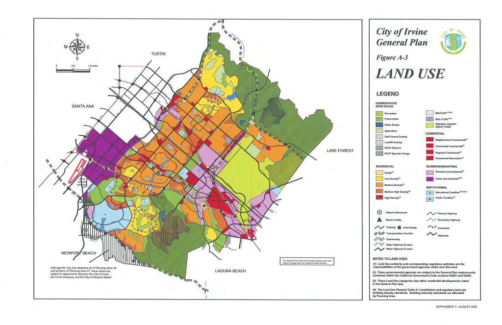
1 City of Irvine - William Lyon Homes: Vista Verde Land Use and Planning Land Use and Planning Introduction This section describes existing land uses, applicable land use plans, policies or regulations, and any potential conflicts that may arise through Project implementation. Descriptions and analysis in this section are derived from field observation, review of pertinent planning documents including the City s General Plan, and from project information contained in Appendix A, Notice of Preparation and Correspondence Environmental Setting University Park Planning Area (PA) 20 encompasses approximately 592 acres within the central portion of the City of Irvine. It is bound by the San Diego Freeway (Interstate 405) to the north, Culver Drive to the west, and University Drive to the south and east. The Village of University Park includes approximately 503 residential acres, 22 commercial acres, and 19 open space acres (recreation). The residential acres are further broken down by Low Residential (93 acres), Medium Residential (296 acres) and Medium-High Residential (114 acres). The Vista Verde residential project is located within the east portion of PA 20 along Michelson Drive, a two-lane divided roadway that runs east-west through the planning area. The 8.47-acre Vista Verde parcel (APN ) is located on Michelson Drive between Yale Avenue and Rosa Drew Lane. The site is bound by Michelson to the north, Rosa Drew Lane to the east and southeast, the Parkside Recreation Center and Dave Robins Park to the southwest, and homes along Cottonwood to the west. Onsite Land Uses The project site is the former Vista Verde Elementary School currently owned by Irvine Unified School District (IUSD). After the school use on site ceased in 2005, the Pacific Pointe Church began use of the school in The school is used by the Pacific Pointe Church for weekly Sunday services from 10:00-11:30am and occasionally on Wednesday evenings for church activities. Features of the site include a main school building, four portable classroom structures, playground areas, grass-covered areas, an athletic field, and associated parking areas. Surrounding Land Uses The site is located within a residential area adjacent to Dave Robins Park, a private neighborhood park. Surrounding land uses include: North - Michelson Drive, attached condominium residences across Michelson Drive, and Rancho San Joaquin Middle School South - Rosa Drew Lane, single-family residences across Tamarack Lane East - Rosa Drew Lane, Parkwood Apartments across Rosa Drew Lane Michael Brandman Associates 3.5-1
2 Land Use and Planning City of Irvine - William Lyon Homes: Vista Verde West - Single-family residences, Dave Robins Park, and recreation center Existing General Plan Designation The Project site s current General Plan land use designation is Institutional-Educational Facilities. This land use category includes public and private schools and support facilities from kindergarten through college/university levels and allows residential developments as noted in the General Plan text (pursuant to Land Use Element Figure A-3, note 3). The General Plan land use designations for the areas surrounding the site are Institutional-Educational Facilities to the north (Rancho Middle School), Medium Density Residential to the north, west, and southwest, and Medium High Density Residential to the east. The Medium Density areas permit an overall density of up to 12.5 dwelling units per acre, and include single-family homes in the Parkside Neighborhood to the west and to the southwest, and single-family attached homes to the north along Michelson Drive. The Medium High Density area permits an overall density of up to 31 dwelling units per acre and includes the Parkwood Apartments to the east along Rosa Drew Lane. Existing Zoning Designation The project site is designated as 6.1 Institutional in the City of Irvine Zoning Ordinance. This designation allows for a variety of permitted uses, including schools, parks, residential shelters, and wireless communications facilities, and conditionally permitted uses including churches, community facilities, childcare centers, conference facilities, government facilities, and hospitals. Zoning for areas surrounding the project site includes the 6.1 Institutional district (Rancho Middle School), 2.2B Low-Density Residential district (Parkside Neighborhood), and 2.4B Medium-High Density Residential district (Parkwood Apartments). Regional Comprehensive Plan and Guide Orange County and the City of Irvine are located at the western edge of a six-county metropolitan region composed of Orange, Los Angeles, Ventura, Riverside, San Bernardino, and Imperial Counties. The Southern California Association of Governments (SCAG) serves as the federally recognized Metropolitan Planning Organization for this Southern California Region. Orange County and its jurisdictions constitute the Orange County subregion within the SCAG region. The Orange County subregion is governed by the Orange County Council of Governments (OCCOG). SCAG has developed a Regional Comprehensive Plan (RCP), which is a major advisory plan that addresses important regional issues like housing, traffic/transportation, water, and air quality. The most recent version of the RCP (adopted in 2008) is an advisory plan only. This plan identifies voluntary best practices to approach growth and infrastructure challenges in an integrated and comprehensive manner and includes goals and outcomes to measure progress toward a more sustainable region. The RCP is an advisory document to local agencies in the Southern California region for their information and voluntary use for preparing local plans and handling local issues of regional importance. SCAG s RCP includes a package of policies related to growth and development that Michael Brandman Associates
3 City of Irvine - William Lyon Homes: Vista Verde Land Use and Planning seek to coordinate infrastructure with projected population and housing growth. In general, SCAG policies encourage job and housing opportunities to be balanced at the county or Regional Statistical Area (both much larger than the project level). SCAG policies also encourage job growth to be concentrated near transit services and transit nodes, and existing freeways, HOV lanes, and toll roads. Given the expansive scope of and general nature of the RCP, not all of these policies apply to every project. This project is not of region-wide significance per SCAG Intergovernmental Review (IGR) criteria and CEQA Guidelines (Section 15206). The project is not a residential development of more than 500 units, and therefore an analysis of project consistency with the RCP is not required Thresholds of Significance According to Appendix G of the CEQA Guidelines, a project would normally have a significant effect on the environment if it would: b) Conflict with any applicable land use plan, policy, or regulation of an agency with jurisdiction over the project (including, but not limited to the general plan, specific plan, local coastal program, or zoning ordinance) adopted for the purpose of avoiding or mitigating an environmental effect. The Initial Study included in Appendix A provides substantial evidence that impacts associated with the following thresholds would have no impact: a) Physically divide an established community. c) Conflict with any applicable habitat conservation plan or natural community conservation plan. Therefore, these topics are not addressed in the following impact analysis Project Impacts Land Use Plan, Policy or Regulatory Conflict Impact LUP-1 Would the project conflict with any applicable land use plan, policy, or regulation of an agency with jurisdiction over the project (including but not limited to the general plan, specific plan, local coastal program, or zoning ordinance) adopted for the purpose of avoiding or mitigating an environmental effect? Impact Analysis The current General Plan land use designation is Institutional-Educational Facilities. The Project site s current zoning designation, 6.1 Institutional, does not allow for residential development of the nature proposed by the applicant. As a result, the project includes requests for: Michael Brandman Associates 3.5-3
4 Land Use and Planning City of Irvine - William Lyon Homes: Vista Verde A General Plan Amendment ( PGA) to: 1) change the site s land use designation to Medium Density Residential (MDR), to 2) increase the General Plan residential cap for Medium Density Residential by 66 units, and 3) to decrease the non-residential cap by 38,871 square feet (see Table 3.5-1). Note that there will be an increase of 15 Medium Density Residential Units due to the fact 51 unallocated units in University Park will be utilized by the Project. Thus, the difference between the 66 proposed units and the 51 unallocated units is 15 units, as indicated by the * symbol in the table below. Table 3.5-1: General Plan Amendment - University Park Planning Area 20 General Plan Category Existing General Plan Intensity Cap (du/sf) Added/ (Deleted) Intensity (du/sf) Proposed General Plan Intensity Cap (du/sf) Medium Density Residential 1,717 du 66 du 1,783 du Planning Area Total Residential 2,805 du 66 du 2,820 du * Institutional-Educational Facility 155,078 sf (38,871 sf) 116,207 sf Planning Area Total Non- Residential 365,556 sf (38,871 sf) 326,685 sf Notes: * The increase of 15 Medium Density Residential units is proposed due to the fact there are currently 51 unallocated units in University Park. This reflects proposed amendment to General Plan Table A-1: Maximum Intensity Standards by Planning Area. Source: City of Irvine. A Zone Change ( PZC) to change the zoning designation to 2.3B Medium Density Residential (Table 3.5-2). The Project would add 66 dwelling units to the existing Maximum Building Intensity of 98 dwelling units, for a revised maximum building intensity of 164 dwelling units. Additionally, the planning area total residential cap would be changed by the addition of the 66 dwelling units. The existing maximum building intensity would increase from 2,754 dwelling units to 2,820 dwelling units. The Institutional 6.1 Educational Facilities existing maximum building intensity would be reduced by 38,871 square feet from 155,078 square feet to 116,207 square feet. In addition, the Planning Area total non-residential existing maximum building intensity would be reduced by 38,871 feet and would change from 402,630 square feet to 363,759 square feet. The changes above would be reflected in the intensity tables in the Zoning Code s Chapter Michael Brandman Associates
5 City of Irvine - William Lyon Homes: Vista Verde Land Use and Planning Table 3.5-2: Zone Change - University Park Planning Area 20 Zoning District Existing Maximum Building Intensity (du/sf) Added/(Deleted) Building Intensity (du/sf) Revised Maximum Building Intensity (du/sf) Medium Density Residential 2.3B 98 du 66 du 164 du Planning Area Total Residential 2,754 du 66 du 2,820 du Institutional Educational Facilities Planning Area Total Non- Residential 155,078 sf (38,871 sf) 116,207 sf 402,630 sf (38,871 sf) 363,759 sf Notes: Reflects proposed amendment to Statistical Analysis table of Section of the Zoning Code. Source: City of Irvine. There is also a Master Plan ( PMP) application, a Park Plan ( PPP) application and a Tentative Tract Map ( PTT), along with the current environmental review. Compatibility of the Vista Verde Residential Project with the Surrounding Area Existing residential uses, local streets and a private neighborhood park surround the Project site within the General Plan Medium Density Residential and Medium High Density land use categories. Surrounding residential uses include single-family detached and attached homes within the 2.2 Low- Density Residential zoning district, and apartments within the 2.4B Medium-High Density Residential zoning district (Exhibit and Exhibit 3.5-2) The Project proposes a total of 66 singlefamily detached homes with an overall density of 7.8 dwelling units per acre (du/ac). This density is within the maximum limits of the MDR designation of 12.5 du/ac. Potential land use compatibility issues are focused on the Project interface with surrounding residential developments. The existing school s peripheral open space/berm and school building setbacks along Michelson Drive and Rosa Drew Lane will be reduced by Project landscaped residential setbacks along these streets. These setbacks will conform to Medium Density Residential standards (with rear yard setbacks of 10 feet) with slope landscaping to include shrubs, perimeter accent trees, and street trees. No significant compatibility impact would occur at these locations. The project abuts the Parkside Recreation Center and Dave Robins Park to the southwest. The singlefamily homes are compatible with these recreational facilities. Existing homes along Cottonwood are currently separated from school buildings on the project site by a block wall, school parking lot and open playfields. The Project would locate single-family homes adjacent to rear yards of these existing single-family residences along Cottonwood. This condition of abutting single-family homes is common within Irvine, University Park, and the adjacent Parkside Neighborhood, and is regulated from a compatibility standpoint by compliance with rear yard setback standards. As an additional design feature to soften the interface of existing and new homes along Michael Brandman Associates 3.5-5
6 Land Use and Planning City of Irvine - William Lyon Homes: Vista Verde this common boundary, the project proposes placement of screening trees along the block wall in the rear yards of the new homes. No significant land use compatibility impact would occur along this interface with the project. The Project is generally compatible with the densities and residential character of the surrounding area. As a result, the project is considered environmentally compatible with surrounding land uses and no significant impacts are anticipated. General Plan Consistency The Institutional-Educational Facilities land use category allows certain types of residential development as specifically noted in the General Plan text. The project will require a General Plan Amendment (GPA) to increase the maximum number of dwelling units in University Park PA 20 by 66 units and to bring the land use designation into conformance with the proposed Zone Change to Medium Density Residential. An increase in the allowable number of residential units in PA 20 would increase the City s housing stock and improve jobs/housing balance (see Section 3.7 Population and Housing). An analysis of the consistency of the Project with General Plan elements and applicable policies is presented below: Land Use Element The Project proposes amending the General Plan Land Use Element to designate the project site as Medium Density Residential. The Medium Density Residential land use category provides for the development of attached and conventional detached housing and other types of residential uses that have open space characteristics similar to single-family neighborhoods. Since the Project proposes to locate 66 single-family detached homes in close proximity to existing residential neighborhoods of a similar density, the Project complies with the Medium Density Residential land use category. Further guidance in the development of the Project site is provided by General Plan Policies A-4(a), A-6(h), and A-6(i). The applicable components of these policies are excerpted and addressed below: Objective A-4: Balanced Land Uses. Manage growth to ensure balanced residential and nonresidential development throughout the City. Policy (a): Ensure that land uses enable the City to provide necessary municipal services by: Implementing and monitoring Statistical Tables A-1 and A-2. Consistency Analysis: Necessary adjustments to statistical tables A-1 (Maximum Intensity Standards by Planning Area) and A-2 (Non-Regulatory Maximum Intensity Standards: Land Use Acreage by Planning Area) will be made as a result of the proposed GPA for the Project. The proposed GPA would increase the maximum number of residential units allowed in the University Park Planning Area 20 and the City by 66 dwelling units, and would result in a corresponding decrease in non-residential square footage by 38, Michael Brandman Associates
7
8

9
10
11 City of Irvine - William Lyon Homes: Vista Verde Land Use and Planning The proposed GPA and Zone Change will improve the existing job/housing balance within the City consistent with Objective A-4. Policy (c): Achieve a land use balance through the following methods: Coordination of land use and circulation patterns to ensure adequate circulation capacity and infrastructure. Promotion of a diversity of housing types and affordability to meet the development objectives of the housing element. Designation of sufficient institutional land to meet the needs of each planning area. Provision of adequate housing opportunities to support employment growth. Provision of open space areas. Consistency Analysis: The Project represents an infill development on a former school site that is no longer needed to meet the institutional-educational facilities needs of the planning area and community. Additionally, the Project, being an infill project, helps the City meet the goals of SB 375, which encourages in-fill development in urbanized areas. The site is located in area with established circulation patterns and existing roads with adequate capacity to serve the Project. The Project proposes conventional single-family detached homes consistent with the character of the surrounding neighborhood and objectives of the housing element. Housing provided by the Project will provide jobs/housing balance to support the City s existing employment base. Although the Project will remove open areas associated with the former school site, the Project includes a Park Plan, which proposes payment of park in-lieu fees to fulfill the community park requirement or if annexed, developer-constructed improvements to the existing Dave Robins Park. No significant conflict with the land use balance objective is anticipated. Objective A-6: Land Use Compatibility. Achieve harmonious land use patterns throughout the City. Policy (a): Ensure, through the discretionary review process, the public health, safety, and welfare of sensitive receptors and land uses when locating such uses in proximity to the following land uses: Uses that handle, generate, and/or transport hazardous substances (as defined by federal and state regulations) Uses that create excessive noise Uses that create excessive dust Uses that create other land use conflicts At the same time, ensure that the proposed sensitive receptors/land uses will not have an impact on the continued operation and/or expansion of the following land uses: Michael Brandman Associates
12 Land Use and Planning City of Irvine - William Lyon Homes: Vista Verde Airports Surface utilities Offsite hazardous waste facilities Solid waste facilities Manufacturing uses Research and development uses Mining and processing uses Any land use that handles, generates, and/or transports hazardous substances as defined by federal and state regulations Consistency Analysis: As with the former school use of the site, the Project would locate a sensitive receptor land use (i.e. residential) on the project site. However, the new homes would be located within an established residential neighborhood of the University Park Planning Area. No uses that would handle, generate or transport hazardous substances, that would create excessive noise or dust, or that would result in other land use conflicts exist or are planned in proximity to the Project. As the residential project is not located near any airport, surface utilities, solid waste or hazardous waste facilities, manufacturing uses, research and development uses, or mining and processing uses, the project would have no impact on the operations or expansion potential for such uses. The Project would not conflict with any public health, safety, and welfare objectives of the General Plan. Note that remaining Policies (b) through (h) all deal with locating sensitive receptors near hazardous waste, landfill, airports, or similar facilities, and therefore do not apply to the Project for similar reasons. Circulation Element The project site is located at 5144 Michelson Drive in University Park. A traffic study has been prepared in order to adequately and accurately determine the overall traffic impacts of the Project. As discussed in Section 3.9, Transportation and Traffic, the construction and operation of the project would not cause any significant and unavoidable impacts. The Project will further the intent of several Circulation Element policies and objectives, including the following: Objective B-2: Roadway Design. Develop a vehicular circulation system consistent with high standards of transportation engineering safety and with sensitivity to adjoining land uses. Policy (a): Align roadways in relationship to adjoining land uses to minimize noise and visual impacts. Consistency Analysis: Vehicular access to the Project would occur via a new interior loop road utilizing a single full intersection at Michelson Drive. This intersection has been located near the existing school site driveway entrance/exit to Michelson Drive to minimize new noise and visual impacts to surrounding residences. A left turn pocket into the site along westbound Michelson will be provided. Daily traffic volumes and movement through this intersection would be well within the capacities of local residential streets and would be controlled by a STOP sign. The project Michael Brandman Associates
13 City of Irvine - William Lyon Homes: Vista Verde Land Use and Planning intersection at Michelson Drive will be designed to provide adequate sight distance for vehicles exiting the project, consistent with City of Irvine traffic safety standards. Policy (e): Design roadways which: Discourage through traffic in residential neighborhoods. Prohibit parking on all thruways, parkways, and community collectors. Limit the routes, speeds, and operation types of trucks and buses. Consistency Analysis: The project interior loop road with single access point at Michelson Drive avoids any potential for cut-through traffic within residential neighborhoods. Parking would occur within the interior of the project without any spillover impact on thruways, parkways, and community collectors (e.g., Michelson Drive, Rosa Drew Lane). All vehicles would be required to follow posted speed limits and established routes. Policy (f): Visually enhance the appearance of roadways and parking areas through design techniques and landscaping. Particular attention should be paid to streetscape design and the creation of new, and preservation of existing, view corridors. Consistency Analysis: Project landscape and parking plans will be reviewed by the City for conformance to established development standards, including perimeter streetscape design and views. Policy (g): Include mitigation measures in the approval of all proposed developments to minimize negative impacts of the automobile. Consistency Analysis: As discussed in Section 3.9, Transportation and Traffic, the construction and operation of the Project would not cause any significant and unavoidable impacts. Based on City of Irvine thresholds of significance, no transportation and traffic mitigation measures would be needed for the Project. Housing Element The Goal of the Housing Element reads, Provide for safe and decent housing for all economic segments of the community. One component necessary for the provision of safe and decent housing is an affordable housing strategy. The strategy for the project is currently being prepared and it is anticipated that with the approval of the strategy by the City there will be adequate housing provided for all economic segments of the community. The City s Fair Share for the planning period from January 1, 2006 through June 30, 2014, was established by SCAG at 35,660 units. 1 Given this need, the project site s ultimate 66 dwelling units would incrementally help the City improve its jobs- 1 Note that per the City of Irvine General Plan, SCAG reports that the City s regional housing need is 10,782 dwelling units (City of Irvine General Plan Page C-50). The current regional housing needs assessment (RHNA) of 35,660 units is noted in the text above because it is a more updated figure than what is in the City s General Plan. Michael Brandman Associates
14 Land Use and Planning City of Irvine - William Lyon Homes: Vista Verde housing balance and help the City meet its SCAG defined need by reducing the number of needed new units to 10,716. Seismic Element The Project site is mapped in the Seismic Element as being within Seismic Response Area 2 (SRA- 2), which is characterized by denser soils, deeper groundwater, and low potential for seismic hazards. Both the State and the City have building code requirements to address this designation. A Geotechnical Due-Diligence Review has been prepared for the project indicating no significant potential for liquefaction hazards. The document indicates the site is considered developable utilizing standard grading techniques similar to the existing former school and surrounding neighborhood. The Project will be constructed in compliance with recommendations of the final geotechnical report, therefore mitigating any negative impact. Cultural Resources Element The Cultural Resources Element of the General Plan has a goal that states: Ensure the proper disposition of historical, archaeological, and paleontological resources to minimize adverse impacts, and to develop an increased understanding and appreciation for the community s historic and prehistoric heritage, and that of the region. Given the fact that the site has been previously disturbed through development of the closed Vista Verde Elementary School, it is not anticipated that any archaeological or paleontological resources are present Onsite. Implementation of City Standard Conditions requiring cultural resources monitoring for development projects would mitigate any potential impact and assure compliance with Cultural Resources Element goals and objectives. Noise Element The goal of the Noise Element is, Contribute to a healthy and safe environment by minimizing noise impacts. This goal will be met through the design of the residential project, and the implementation of recommendations specified in the project Acoustical Assessment, which demonstrates that the project complies with the City noise ordinance. The Acoustical Assessment applies the interior noise standards and land use compatibility standards contained in the Noise Element and Noise Ordinance. Public Facilities and Services Element The Public Facilities and Services anticipated and required by this General Plan Element include Police Services, Fire Services, School Facilities, Library Services, Child Care Centers, Senior Centers, Community Center/Youth Center and Swimming Pools. All of these public facilities are being addressed throughout the processing of the project through the City of Irvine. For example, the Irvine Police Department and the Orange County Fire Authority (OCFA) are responsible for reviewing the Project plans for compliance with their regulations. Additionally, the Project proposes to address the recreation needs of future residents and applicable parks requirements through the payment of in-lieu fees. Also, the project site is an infill development in an area that is built out and on a site that is already served by public services and utilities Michael Brandman Associates
15 City of Irvine - William Lyon Homes: Vista Verde Land Use and Planning Integrated Waste Management Element The Goal of the Integrated Waste Management Element states: Encourage solid waste reduction and provide for the efficient recycling and disposal of refuse and solid waste material, without deteriorating the environment. The Project will include both trash and recycling collections, consistent with City of Irvine code requirements and therefore the Project will be in conformance with the Integrated Waste Management Element. Energy Element The stated Goal of the Energy Element is, Promote energy conservation and the use of renewable energy sources throughout the City in a cost effective way. The Project will be designed in compliance with Title 24 of the State Building Code. This Title requires certain features be incorporated into the design of a project in order to reduce energy consumption. With Title 24 compliance, the Project will meet the goal by conserving energy. The Project will be constructed in conformance with the 2010 California Building code including its provisions for Green Building Standards and Title 24. Safety Element The stated goal of the Safety Element is, Minimize the danger to life and property from man made and natural hazards, including fire hazards, flood hazards, non-seismic geologic hazards, and air hazards. This goal is reached through implementation of the Project. The Project will be constructed consistent with all applicable building and zoning code statutes. Being that the Project is located in a built suburban environment, there are no areas of high fire hazard within close proximity. Any potential flood hazard will be mitigated through compliance with the City s established grading regulations. Parks and Recreation Element The stated goal of the Parks and Recreation Element is: Provide park and recreation opportunities at a level that maximizes available funds and enables residents of all ages to utilize their leisure time in a rewarding, relaxing and creative manner. This goal will be satisfied through the Project s Park Plan, which proposes payment of park in-lieu fees to fulfill the community park requirement while annexation is being pursued. Payment of Park In-Lieu fees will be consistent with the most recent City Council adopted fee resolution. Conservation/Open Space Element The goal of the Conservation and Open Space Element reads, Maintain and preserve the environmental systems as a major feature in the City. The Project will not impede attainment of this goal. The Project site is located within northerly portion of the San Joaquin Hills landform zone as described in the Element (Figure L-1), with no connectivity or adjacency to any areas of permanent natural open space. Michael Brandman Associates
16 Land Use and Planning City of Irvine - William Lyon Homes: Vista Verde Growth Management Element The Goal of the Growth Management Element reads, To ensure that growth and development are integrally planned with, and phased concurrently with, the City of Irvine s ability to provide an adequate circulation system and public facilities. The goal of this Element is satisfied and addressed through project implementation. Consistent with Circulation Element goals, a traffic study has been prepared in order to determine the overall traffic impacts of the project. The traffic study indicates that an adequate circulation system exists to accommodate the growth represented by this new infill residential development, and no significant and unavoidable traffic impacts would occur. Additionally, Objective M-6 of the Element looks to promote balanced growth of residential and nonresidential land uses and supporting public facilities and services. The Project supports this Objective by providing a residential land use near Irvine job centers (i.e. IBC, Spectrum, etc.), thus potentially reducing the travel time and commute costs for the future residents who might otherwise be forced to live farther from their place of work. Zoning Ordinance Consistency The City Zoning Ordinance designates the project site as 6.1 Institutional. This designation allows for a variety of uses, including schools, parks, churches, hospitals, residential care facilities, government and community facilities, and conference centers. However, a Zone Change would be required for the development of 66 residential units at the site. This will be accomplished through the Zone Change application that is part of the Project. Consistency with Regional Comprehensive Plan and Guide Policies As noted in Section above, the Vista Verde residential project is not a project of region-wide significance per SCAG Intergovernmental Review (IGR) criteria and CEQA Guidelines (Section 15206), and therefore does not require this EIR to address project consistency with the RCPG. Note that the Regional Comprehensive Plan and Guide is an advisory document only and the City of Irvine is not required to be consistent with it. Level of Significance Before Mitigation The following impact is considered less than significant because the Project includes a General Plan Amendment and Zone Change. Impact LUP-1 The project is not consistent with the existing General Plan and Zoning designations for the site. Mitigation Measures No mitigation measures are required. Level of Significance After Mitigation Less Than Significant Michael Brandman Associates
4. ENVIRONMENTAL IMPACT ANALYSIS 7. LAND USE AND PLANNING
 4. ENVIRONMENTAL IMPACT ANALYSIS 7. LAND USE AND PLANNING 4.7.1 INTRODUCTION The following analysis discusses the consistency of the Proposed Project with the corresponding land use and zoning designations
City Of Sparks Planning Commission Item
 Page 1 of 12 City Of Sparks Planning Commission Item Meeting Date: May17, 2012 Subject: PCN12009, Public Hearing, Consideration and possible action on a Master Plan Amendment and Rezoning request to change
SECTION 4.8 LAND USE DRAFT ENVIRONMENTAL IMPACT REPORT DEEP VALLEY DRIVE AND INDIAN PEAK ROAD MIXED-USE RESIDENTIAL PROJECT
 LSA ASSOCIATES, INC. J UNE 2012 SECTION 4.8 LAND USE 4.8 LAND USE Introduction Comprising 10.4 acres (ac), the proposed project site is located in the City of Rolling Hills Estates (City) between Deep
RECREATION AND OPEN SPACE ELEMENT GOALS, OBJECTIVES, AND POLICIES
 RECREATION AND OPEN SPACE ELEMENT GOALS, OBJECTIVES, AND POLICIES Goal 7 To provide park facilities, recreation programs, and open space resources that are safe, adequate, and accessible to all City residents,
Glenborough at Easton Land Use Master Plan
 Implementation 114 9.0 IMPLEMENTATION 9.1 OVERVIEW This chapter summarizes the administrative procedures necessary to implement the proposed land use plan, infrastructure improvements, development standards,
AWH REPORT OF THE PLANNING AND DEVELOPMENT DEPARTMENT FOR APPLICATION FOR REZONING ORDINANCE TO PLANNED UNIT DEVELOPMENT
 AWH REPORT OF THE PLANNING AND DEVELOPMENT DEPARTMENT FOR APPLICATION FOR REZONING ORDINANCE TO PLANNED UNIT DEVELOPMENT MAY 8, 2014 The Planning and Development Department hereby forwards to the Planning
Venice Pumping Plant Dual Force Main Project Draft EIR
 City of Los Angeles 5.9 LAND USE PLANS 5.9.1 Environmental Setting Venice Pumping Plant Dual Force Main Project Draft EIR The Project lies within the bounds of Los Angeles County and the City of Los Angeles.
5.9 LAND USE Existing Conditions Historic Land Use Trends Existing Land Use Distribution
 5.9 LAND USE This section describes the existing land use pattern and land use planning/regulatory framework in the City of Fontana. It also evaluates potential long-term land use impacts such as physically
Planned Development Review Revisions (Project No. PLNPCM )
") Planned Development Review Revisions (Project No. PLNPCM2014-00139) Standard residential development Planned Development Example: Smaller lot sizes than what is allowed to create open space amenity. What
Planned Development Review Revisions (Project No. PLNPCM2014-00139) Standard residential development Planned Development Example: Smaller lot sizes than what is allowed to create open space amenity. What
Town of Portola Valley General Plan. Nathhorst Triangle Area Plan
 Town of Portola Valley General Plan Amended December 10, 1997 Table of Contents Introduction... 1 Planning Area... 1 Objectives... 2 Principles... 2 Standards... 4 Description... 4 Community Commercial...
CHAPTER 2 SUMMARY 1. PROJECT SUMMARY DATA
 CHAPTER 2 SUMMARY This is an Initial Study format used to determine, pursuant to CEQA Guidelines Section 15177, whether a project 1) is within the scope of a Master EIR (MEIR), 2) may result in additional
Planning & Zoning Commission Staff Report
 Planning & Zoning Commission Staff Report Meeting Date: May 26, 2015 Drafted by: Katherine Harrison-Rogers CASE # Z2886 PROJECT NAME: APPLICANT/ REPRESENTATIVE: Shawna Runyan PROPERTY OWNER: 1840 (previously
3.10 LAND USE SETTING PROJECT SITE EXISTING LAND USE DESIGNATIONS AND ZONING. General Plan Land Use Designations.
 This section of the Draft EIR addresses the existing land uses on and adjacent to the project site and discusses the potential impacts of the proposed project on existing land uses. Key issues addressed
4.1.3 LAND USE CATEGORIES
 4.1.3 LAND USE CATEGORIES a. City Center District The City Center District incorporates the existing character and mix of uses in downtown Belmont to encourage redevelopment and new development in keeping
APPENDIX D: BACKGROUND AND VISION
 APPENDIX D: BACKGROUND AND VISION BACKGROUND A. Specific Plan Location Jordan Downs is located at 9800 Grape Street in Los Angeles, California, 90002. The Jordan Downs Urban Village Specific Plan area
ALBEMARLE COUNTY CODE CHAPTER 18 ZONING SECTION 20A NEIGHBORHOOD MODEL - NMD
 CHAPTER 18 ZONING SECTION 20A NEIGHBORHOOD MODEL - NMD Sections: 20A.1 PURPOSE AND INTENT 20A.2 STATUS AS A PLANNED DEVELOPMENT DISTRICT 20A.5 CODES OF DEVELOPMENT 20A.6 PERMITTED USES 20A.7 RESIDENTIAL
Baumgarten MPUD. Exhibit 3 Evaluation Criteria
 Pursuant to LDC subsections 10.02.13 B, 10.02.08 F and Chapter 3 G. of the Administrative Code, staff s analysis and recommendation to the Planning Commission, and the Planning Commission s recommendation
CHAPTER 1. Ms. Guajardo s Class - Central Elementary CH 1 1
 INTRODUCTION CHAPTER 1 Ms. Guajardo s Class - Central Elementary CH 1 1 1.1 SETTING South Centre City is a linear corridor south of Downtown Escondido paralleling Centre City Parkway and South Escondido
A. WHAT IS A GENERAL PLAN?
 I. Introduction A. WHAT IS A GENERAL PLAN? A general plan is the planning guideline for the future of a city. It contains goals and policies which regulate urban development, the protection of the natural
2. INTRODUCTION 2.1 AUTHORITY 2.2 PURPOSE AND INTENT 2.3 SITE LOCATION
 2. INTRODUCTION 2.1 AUTHORITY The City of Gardena initiated and prepared the Artesia Corridor Specific Plan pursuant to the provisions of California Government Code, Title 7, Division 1, Chapter 3, Article
NEW CASTLE COUNTY S ZONING DISTRICTS
 NEW CASTLE COUNTY S ZONING DISTRICTS This is general information about New Castle County s zoning districts. The information included is by no means exhaustive or complete. Before designing plans to develop
4.1 LAND USE AND PLANNING EXISTING CONDITIONS REGULATORY BACKGROUND LAND USES IN THE PLAN AREA SURROUNDING LAND USES
 4.1 LAND USE AND PLANNING This section includes a description of the existing land use plans that apply to the Plan area and a description of existing land uses in the vicinity. It also includes an analysis
6. REGIONAL AND COMMUNITY FACILITIES DESIGNATIONS 6.1. OBJECTIVES FOR REGIONAL AND COMMUNITY FACILITIES LAND USE DESIGNATIONS
 6. REGIONAL AND COMMUNITY FACILITIES DESIGNATIONS INTRODUCTION The Regional and land use designations provide the primary locations for uses which satisfy the health, education and other service needs
Planning Commission Staff Report June 5, 2008
 Owner/Applicant Taylor Village Sacramento Investments Partners, LP c/o Kim Whitney 1792 Tribute Road #270 Sacramento, CA 95815 Staff Recommendation Planning Commission Staff Report Project: File: Request:
Planned Residential Neighborhoods Land Use Goals
 Planned Residential Neighborhoods Land Use Goals Issue: Guidelines that provide for diverse high quality residential areas that include a variety of housing styles and layouts are needed. Goal 1: Create
No comments related to land use and planning issues were received in response to the Notice of Preparation.
 4.8 LAND USE AND PLANNING This section analyzes the impacts relative to land use and planning that would occur as a result of implementation of the proposed Facilities Master Plan (proposed project). This
MASTER PLAN. 201 Planning Concepts. Chapter 2
 Chapter 2 MASTER PLAN 201 Planning Concepts 202 Master Land Use Plan 203 Affordable Housing Program 204 Parks, Open Space, and Recreation Trails 205 Grading Concept 206 Circulation Plan 207 Landscape Concept
CHAPTER 13 DESIGN GUIDELINES
 CHAPTER 13 DESIGN GUIDELINES Section 1300.00 Section 1300.01 Design Guidelines Purpose The purposes of this section are to: A. The purpose of this Section is to establish procedures and standards to serve
1 INTRODUCTION. A. Purpose of this General Plan
 1 How will Chino become a healthier place to live, work, and play? The City has established community health as a focus of this General Plan. Health touches all aspects of a community, from where residents
4.8 LAND USE AND PLANNING
 4.8 LAND USE AND PLANNING 4.8.1 INTRODUCTION This section describes existing and planned land uses at the Hayward campus and analyzes the impact of implementation of the proposed Master Plan on land uses
Appendix C: Aesthetics
 City of Irvine - William Lyon Homes: Vista Verde Draft EIR Appendix C: Aesthetics Michael Brandman Associates H:\Client (PN-JN)\0006\00060034\EIR\3 - DEIR\00060034 Sec99-00 Appendix Dividers Vista Verde.doc
Chapter Master Planned Communities (MPC) District
 District") Sections 14.53.010 Purpose and Intent 14.53.020 Applicability 14.53.030 Procedure 14.53.040 MPC Standards 14.53.050 Required Findings 14.53.010 Purpose and Intent Chapter 14.53 Master Planned Communities
Sections 14.53.010 Purpose and Intent 14.53.020 Applicability 14.53.030 Procedure 14.53.040 MPC Standards 14.53.050 Required Findings 14.53.010 Purpose and Intent Chapter 14.53 Master Planned Communities
Town Center (part of the Comprehensive Plan)
") Town Center (part of the Comprehensive Plan) Mercer Island Town Center Looking North (2014) In 1994, a year-long process culminated in a set of design guidelines and code requirements for the Town Center
Town Center (part of the Comprehensive Plan) Mercer Island Town Center Looking North (2014) In 1994, a year-long process culminated in a set of design guidelines and code requirements for the Town Center
OFFICE CONSOLIDATION SECONDARY PLAN AREA 22 THE BRAMALEA SOUTH INDUSTRIAL SECONDARY PLAN
 OFFICE CONSOLIDATION SECONDARY PLAN AREA 22 THE BRAMALEA SOUTH INDUSTRIAL SECONDARY PLAN November 2010 EXPLANATORY NOTES (Secondary Plan Area 22) General (pertaining to all secondary plan office consolidations)
SAN RAFAEL GENERAL PLAN 2040 INTRODUCTION AND OVERVIEW
 SAN RAFAEL GENERAL PLAN 2040 INTRODUCTION AND OVERVIEW Steering Committee Presentation February 14, 2018 Purpose of General Plan Guide land use and development decisions Coordinate transportation, infrastructure,
3.0 PROJECT DESCRIPTION
 3.0 PROJECT DESCRIPTION 3.1 BACKGROUND Under California law (Government Code Section 65300 et seq.), every city and county is required to have a general plan. The general plan is to be comprehensive and
RESOLUTION NO: WHEREAS, the subject property has a Public, Semi-Public (PS) zoning designation and a General Plan designation of Institutional; and
 zoning designation and a General Plan designation of Institutional; and") RESOLUTION NO: A RESOLUTION OF THE CITY COUNCIL OF THE CITY OF PASADENA APPROVING A 14-YEAR, EIGHT-PHASE MASTER PLAN AMENDMENT FOR HUNTINGTON MEMORIAL HOSPITAL LOCATED AT 100 WEST CALIFORNIA BOULEVARD
RESOLUTION NO: A RESOLUTION OF THE CITY COUNCIL OF THE CITY OF PASADENA APPROVING A 14-YEAR, EIGHT-PHASE MASTER PLAN AMENDMENT FOR HUNTINGTON MEMORIAL HOSPITAL LOCATED AT 100 WEST CALIFORNIA BOULEVARD
CHAPTER ADDITIONAL REQUIREMENTS IN THE NC, NEIGHBORHOOD COMMERCIAL ZONE
 CITY OF MOSES LAKE MUNICIPAL CODE CHAPTER 18.31 ADDITIONAL REQUIREMENTS IN THE NC, NEIGHBORHOOD COMMERCIAL ZONE Sections: 18.31.010 Purpose 18.31.020 Minimum Lot Area 18.31.030 Setbacks 18.31.040 Maximum
REPORT TO PLANNING COMMISSION
 CITY OF Meeting Date: October 25, 2011 Agenda Item: Community Development Department Planning Division P. O. Box 151560, San Rafael, CA 94915-1560 PHONE: (415) 485-3085/FAX: (415) 485-3184 Case Numbers:
PLANNING COMMISSION. Submitted
 PLANNING COMMISSION City Hall 1275 Main Street El Centro, CA 92243 Submitted PLANNING COMMISSION ACTION ITEM (1844) Meeting: 05/10/16 12:00 AM Department: Community Development Category: Public Hearing
Chapter 10 IMPLEMENTATION RECOMMENDATIONS
 Chapter 10 IMPLEMENTATION RECOMMENDATIONS The recommended land use plan presented in the previous chapter provides a design for the attainment of the urban and rural development and open space preservation
ENVIRONMENTAL SETTING
 II. ENVIRONMENTAL SETTING EXISTING CONDITIONS The 208.87-acre Project site is located in the western portion of the City (refer to Figures II-1 and II-2). The Project site comprises Assessor s Parcel Number
4. Shape Transitions. 4. Shape Transitions
 4. Shape Transitions 49 Zoning District Policies Overall Intent: Maintain neighborhood character by creating compatible transitions that minimize land use conflicts. Strategy: Define the character of zoning
3. VISION AND GOALS. Vision Statement. Goals, Objectives and Policies
 Vision Statement Queen Creek s interconnected network of parks, trails, open spaces and recreation opportunities provide safe and diverse activities and programs that sustain its unique, small town, equestrian
CITY OF CYPRESS 5275 Orange Avenue Cypress, California (714) DESIGN REVIEW COMMITTEE PERMIT PROCESS
 DESIGN REVIEW COMMITTEE PERMIT PROCESS") CITY OF CYPRESS 5275 Orange Avenue Cypress, California 90630 (714) 229-6720 DESIGN REVIEW COMMITTEE PERMIT PROCESS 1. Discuss project with Planning staff to determine zoning regulations, any unusual characteristics
CITY OF CYPRESS 5275 Orange Avenue Cypress, California 90630 (714) 229-6720 DESIGN REVIEW COMMITTEE PERMIT PROCESS 1. Discuss project with Planning staff to determine zoning regulations, any unusual characteristics
CONTENTS 8.0 LAND USE 8.1 GENERAL LAND USE 8.2 RESIDENTIAL 8.3 MIXED USE 8.4 COMMERCIAL 8.5 EMPLOYMENT LANDS
 8-2 Land Use 8.0 LAND USE CONTENTS 8.1 GENERAL LAND USE 8.1.1 Uses provided for in all Land Use Designations 8.1.2 Uses prohibited in Hazardous Lands, Hazardous Sites and Special Policy Areas 8.1.3 Uses
Notice of Preparation and Notice of Public Scoping Meeting. At Dublin Project
 Notice of Preparation and Notice of Public Scoping Meeting Date January 17, 2018 To Project Title Project Application Number Project Location Project Applicant Contact For questions or submitting comments.
LAND USE GOALS, OBJECTIVES AND POLICIES. Goal 1: [L] (EFF. 7/16/90)
![LAND USE GOALS, OBJECTIVES AND POLICIES. Goal 1: [L] (EFF. 7/16/90)](/thumbs/88/115018937.jpg "LAND USE GOALS, OBJECTIVES AND POLICIES. Goal 1: [L] (EFF. 7/16/90)") LAND USE GOALS, OBJECTIVES AND POLICIES Goal 1: [L] (EFF. 7/16/90) The Comprehensive Plan shall protect and enhance the quality of life in this community by providing economically sound educational, employment,
LAND USE GOALS, OBJECTIVES AND POLICIES Goal 1: [L] (EFF. 7/16/90) The Comprehensive Plan shall protect and enhance the quality of life in this community by providing economically sound educational, employment,
Dwelling Units Max 12 dwelling units per acre/min 8 dwelling units per acre. Development Mix 80% non residential/20% residential
 13. OSTEEN LOCAL PLAN Background: The Osteen Local Plan area is located in southwest Volusia County along the SR 415 corridor between Lemon Bluff Road and Acorn Lake Road and includes 3,990 acres. The
Review of Opportunity Area C Draft Comprehensive Plan and Draft BOS Follow-On Motions. Special Working Group Meeting March 4, 2015
 Review of Opportunity Area C Draft Comprehensive Plan and Draft BOS Follow-On Motions Special Working Group Meeting March 4, 2015 The slides that follow identify where the draft Comprehensive Plan has
Regency Developments. Urban Design Brief. Holyrood DC2 Rezoning
 Regency Developments Urban Design Brief Holyrood DC2 Rezoning Stantec Consulting Ltd. 7-31-2017 1. Overview Regency Developments intends to rezone the lands located at 8510 and 8511 93 Avenue, within the
TABLE OF CONTENTS. Tables Table UC Davis Park and Open Space Resources
 TABLE OF CONTENTS 4.13 Recreation... 4.13-1 4.13.1 Environmental Setting... 4.13-1 4.13.2 Impacts and Mitigation Measures... 4.13-4 4.13.3 References... 4.13-8 Tables Table 4.13-1 UC Davis Park and Open
Master Zoning Plan for the Northeast Property. in El Paso, Texas. Approved August Master Zoning Plan for the Northeast Property. City of.
 El Paso, Texas in El Paso, Texas Prepared for: City of Prepared by: Texas Kimley-Horn and Associates, Inc. 12700 Park Central Drive Suite 1800 Dallas, Texas 75251 Tel: (972) 770-1300 Approved August 2008
EXHIBIT B PROJECT NARRATIVE POULSBO MEADOWS
 EXHIBIT B PROJECT NARRATIVE POULSBO MEADOWS Name of Project: Poulsbo Meadows; A Planned Residential Development (PRD)/Plat Applicants Name: PBH Group LLC/Byron Harris PO Box 1010 Silverdale, WA 98038 Description
Planning Commission April 4, 2013 BOCC Workshop Page 1
 Planning Commission April 4, 2013 BOCC Workshop Page 1 Planning Commission April 4, 2013 BOCC Workshop Page 2 Planning Commission April 4, 2013 BOCC Workshop Page 3 Planning Commission April 4, 2013 BOCC
COLVER ROAD INDUSTRIAL CONCEPT PLAN
 COLVER ROAD INDUSTRIAL CONCEPT PLAN A CONCEPTUAL LAND USE AND TRANSPORTATION PLAN FOR TA-4 AN URBAN RESERVE AREA OF THE CITY TALENT City of Talent Adopted by City Council Resolution No., June, 2015 PART
CHAPTER 7: Transportation, Mobility and Circulation
 AGLE AREA COMMUNITY Plan CHAPTER 7 CHAPTER 7: Transportation, Mobility and Circulation Transportation, Mobility and Circulation The purpose of the Transportation, Mobility and Circulation Chapter is to
McDonald s Restaurant - Purcellville Town of Purcellville Special Use Permit Statement of Justification July 24, 2014
 Introduction / Written Statement McDonald s Restaurant - Purcellville McDonald s Corporation is proposing to redevelop the existing McDonald s eating establishment with a drive-through located at 121 N
Concord Community Reuse Project Goals and Guiding Principles. Overarching Goals (OG)
") Concord Community Reuse Project Goals and Guiding Principles Overarching Goals (OG) No priority is implied by the order of presentation of the goals and guiding principles. Overarching goals for the Concord
Concord Community Reuse Project Goals and Guiding Principles Overarching Goals (OG) No priority is implied by the order of presentation of the goals and guiding principles. Overarching goals for the Concord
Policies and Code Intent Sections Related to Town Center
 Policies and Code Intent Sections Related to Town Center The Town Center Vision is scattered throughout the Comprehensive Plan, development code and the 1994 Town Center Plan. What follows are sections
ARTICLE IX SPECIAL PERMIT USES
 ARTICLE IX SPECIAL PERMIT USES All special permit uses cited in Article IX and Attachment A of this Ordinance or any other Section of this Ordinance shall be subject to Site Plan Review. The procedures
Asbury Chapel Subdivision Sketch Plan
 Asbury Chapel Subdivision Sketch Plan PART 1: PROJECT SUMMARY Applicant: NVR Inc. Project Size: +/- 76.13 acres Parcel Numbers: 02101112,02116101,02116112, 02116113 Current Zoning: Transitional Residential
LAND USE OVERVIEW WHAT YOU WILL FIND IN THIS CHAPTER
 LAND USE WHAT YOU WILL FIND IN THIS CHAPTER Information about the City s expected population and employment growth. Description and capacity of existing and future land use designations. Policies that
3. Project Description
 3.1 PROJECT LOCATION The Platinum Triangle (herein after also referred to as the Project Area ) is located at the confluence of the Interstate 5 (I-5 Freeway) and the State Route 57 (SR-57 Freeway), in
POCKET COMMUNITY PLAN
 POCKET COMMUNITY PLAN Part Three : COMMUNITY PLAN AREAS AND SPECIAL STUDY AREAS CONTENTS Community Location... 3-P-3 Community Vision... 3-P-4 Community Profile... 3-P-4 Community Issues... 3-P-6 Land
CHAPTER 12 IMPLEMENTATION
 CHAPTER 12 IMPLEMENTATION The 2010 Town of Denton Comprehensive Plan is intended to capture a vision of the future of Denton. As such, it provides a basis for a wide variety of public and private actions
TO: CITY COUNCIL DATE: MARCH 23,2009
 Report TO: CITY COUNCIL DATE: MARCH 23,2009 FROM: CITY MANAGER SUBJECT: MASTER DEVELOPMENT PLAN AMENDMENT FOR PASADENA CHRISTIAN SCHOOL AT 1515 NORTH LOS ROBLES AVENUE AND GENERAL PLAN AMENDMENT AND ZONE
I539. Smales 2 Precinct
 I539. Smales 2 Precinct I539.1. Precinct Description The Smales 2 Precinct applies to a 4.8 hectare block of land located on the southern side of Northcote Road and fronting Lake Pupuke, Takapuna. The
4 RESIDENTIAL ZONE. 4.1 Background
 4 RESIDENTIAL ZONE 4.1 Background The residential areas within the City are characterised by mainly lowrise dwellings sited on individual allotments. Past architectural styles, settlement patterns and
4.0 Future Land Use Element
 4.0 The Florida Agricultural and Mechanical University (FAMU) represents existing and proposed development patterns within the campus boundaries to be coordinated and not conflict with the adjacent areas
URBAN DESIGN BRIEF. 2136&2148 Trafalgar Road. Town of Oakville
 URBAN DESIGN BRIEF 2136&2148 Trafalgar Road Town of Oakville Prepared By: METROPOLITAN CONSULTING INC For 2500674 Ontario Inc November 2016 TABLE OF CONTENTS Page No. 1.0 Introduction/Description of Subject
Infill Residential Design Guidelines
 Infill Residential Design Guidelines Adopted March 23, 2004 Amended September 10, 2013 City of Orange Community Development Department Planning Division Phone: (714) 744-7220 Fax: (714) 744-7222 www.cityoforange.org
TRANSPORTATION ELEMENT GOALS, OBJECTIVES, AND POLICIES
 TRANSPORTATION ELEMENT GOALS, OBJECTIVES, AND POLICIES GOAL 2 The City shall provide a safe, convenient, effective, and energy efficient multimodal transportation system which is coordinated with the Future
APPENDIX J PERFORMANCE STANDARDS FOR GRAVEL MINE, PIT MINE, OR QUARRY
 APPENDIX J PERFORMANCE STANDARDS FOR GRAVEL MINE, PIT MINE, OR QUARRY A. Purpose: 1. Regulatory Requirement and Use Mitigation: The purpose of this appendix is to provide a regulatory context (standards)
ARTICLE 6: Special and Planned Development Districts
 ARTICLE 6: Special and Planned Development Districts 6-10 Traditional Neighborhood Development (TND) District 6-10.10 Purpose and Intent The Traditional Neighborhood Development (TND) District provides
CITY PLANNING COMMISSION AGENDA. ITEM NO(s): C.1 C.3 STAFF: STEVE TUCK
: C.1 C.3 STAFF: STEVE TUCK") Page 34 CITY PLANNING COMMISSION AGENDA ITEM NO(s): C.1 C.3 STAFF: STEVE TUCK FILE NOS: CPC ZC 12-00035 QUASI-JUDICIAL CPC NV 12-00036 QUASI-JUDICIAL AR DP 12-00039 QUASI-JUDICIAL PROJECT: APPLICANT: OWNER:
Page 34 CITY PLANNING COMMISSION AGENDA ITEM NO(s): C.1 C.3 STAFF: STEVE TUCK FILE NOS: CPC ZC 12-00035 QUASI-JUDICIAL CPC NV 12-00036 QUASI-JUDICIAL AR DP 12-00039 QUASI-JUDICIAL PROJECT: APPLICANT: OWNER:
The transportation system in a community is an
 7 TRANSPORTATION The transportation system in a community is an important factor contributing to the quality of life of the residents. Without a sound transportation system to bring both goods and patrons
KASPER. City of Georgetown, Texas PUD Planned Unit Development. December 30, 2015 Revised January 27, 2016
 KASPER City of Georgetown, Texas PUD Planned Unit Development December 30, 2015 Revised January 27, 2016 Applicant: Sentinel Land Company, LLC 4910 Campus Drive Newport Beach, CA Prepared by: SEC Planning
From: Mayor Sam Liccardo Councilmember Chappie Jones Councilmember Dev Davis Subject: SEE BELOW Date: June 23, 2017
 CITY OF fit SAN JOSE CAPITAL OF SILICON VALLEY Memorandum, To: HONORABLE MAYOR AND CITY COUNCIL From: Mayor Sam Liccardo Councilmember Chappie Jones Councilmember Dev Davis Subject: SEE BELOW Date: June
2 Project Description
 Project Description 2 Project Description The proposed project would involve the demolition of the existing church and the construction of 40 twostory single family residences. The residential lots would
CHARLES PUTMAN CHARLES PUTMAN AND ASSOCIATES, INC
 MEMORANDUM CHARLES PUTMAN & ASSOCIATES, INC. LAND DEVELOPMENT CONSULTANTS PLANNING ZONING PERMITTING 4722 NW Boca Raton Boulevard, Suite C-106 Boca Raton, Florida 33431 Phone: 561/994-6411 FAX: 561/994-0447
Incentive Zoning Regulations Florida Municipal City of Orlando
 Topic: Resource Type: State: Jurisdiction Type: Municipality: Year (adopted, written, etc.): 2002 Community Type applicable to: Title: Incentive Zoning Regulations Florida Municipal City of Orlando Document
REPORT OF THE PLANNING AND DEVELOPMENT DEPARTMENT FOR APPLICATION FOR REZONING ORDINANCE TO PLANNED UNIT DEVELOPMENT AUGUST 18, 2016
 REPORT OF THE PLANNING AND DEVELOPMENT DEPARTMENT FOR APPLICATION FOR REZONING ORDINANCE TO PLANNED UNIT DEVELOPMENT AUGUST 18, 2016 AWH The Planning and Development Department hereby forwards to the Planning
GENERAL LAND USE POLICIES
 GENERAL LAND USE POLICIES The County will: GOALS AND OBJECTIVES 7.1 Fiscal Distribute the designation of land uses to balance the costs of providing public services and facilities with generating public
SOUTH NATOMAS COMMUNITY PLAN
 SOUTH NATOMAS Community Plan Part Three : COMMUNITY PLAN AREAS AND SPECIAL STUDY AREAS SACRAMENTO 2030 GENERAL PLAN Contents Community Location... 3-SN-3 Community Vision... 3-SN-4 Community Profile...
Authority of the General Plan
 Authority of the General Plan This La Habra Heights General Plan will serve as the blueprint for future planning and development in the City. This General Plan describes the City s vision for the future
GENERAL PLAN CONSISTENCY ANALYSIS
 GENERAL PLAN CONSISTENCY ANALYSIS Prepared by Planning Staff 10/28/2013 APPLICABLE GOALS, POLICIES AND PROGRAMS FROM the LAND USE CHAPTER Goal LU-1 Policy LU-1.1 Policy LU-1.2 Goal LU-2 Protect the character
4.8 Land Use and Planning Environmental Setting Impacts and Mitigation Measures References...4.
 TABLE OF CONTENTS 4.8 Land Use and Planning...4.8-1 4.8.1 Environmental Setting...4.8-1 4.8.2 Impacts and Mitigation Measures...4.8-5 4.8.3 References...4.8-11 FIGURES Figure 4.8-1 Figure 4.8-2 Figure
Staff Report CONDITIONAL USE
 Staff Report PLANNING DIVISION COMMUNITY & ECONOMIC DEVELOPMENT To: From: Salt Lake City Planning Commission Daniel Echeverria, (801) 535-7165, daniel.echeverria@slcgov.com Date: May 21, 2015 Re: PLNPCM2015-00139
DISCUSSION ON VACAVILLE S2 INVESTORS PROPERTY IN URBAN RESERVE
 Agenda Item No. 9C April 25, 2017 TO: FROM: SUBJECT: Honorable Mayor and City Council Attention: Jeremy Craig, Interim City Manager Barton Brierley, AICP, Community Development Director (Staff Contact:
Vision Statement for the Town of Flower Mound Master Plan The Town of Flower Mound Master Plan furthers the established community based vision to:
 Vision Statement for the The furthers the established community based vision to: Preserve the country atmosphere and natural environment that makes Flower Mound a unique and desirable community; Mitigate
CHUGIAK-EAGLE RIVER SITE-SPECIFIC LAND USE PLAN
 CHUGIAK-EAGLE RIVER SITE-SPECIFIC LAND USE PLAN JUNE 2010 Final Prepared for The Heritage Land Bank, Municipality of Anchorage by Agnew: :Beck Consulting www.agnewbeck.com 907.222.5424 Chugiak-Eagle River
PORT WHITBY COMMUNITY
 PORT WHITBY COMMUNITY SECONDARY PLAN UPDATE COMMUNITY IMPROVEMENT PLAN URBAN DESIGN GUIDELINES September 2015 DRAFT PROPOSED AMENDMENT NUMBER # to the Whitby Official Plan PURPOSE: The intent of this Amendment
RECOMMENDATION REPORT
 DEPARTMENT OF CITY PLANNING RECOMMENDATION REPORT City Planning Commission Case No.: CPC-2012-1165-GPA-ZC Date: August 9, 2012 Time: After 8:30 AM Place: City Hall, Room 350 Public Hearing: Required CEQA
ARLINGTON COUNTY, VIRGINIA
 ARLINGTON COUNTY, VIRGINIA County Board Agenda Item Meeting October 15, 2005 DATE: September 28, 2005 SUBJECT: Request to Advertise the adoption of the 2005 Clarendon Sector Plan C. M. RECOMMENDATION:
Bloor St. W. Rezoning - Preliminary Report
 STAFF REPORT ACTION REQUIRED 1638-1644 Bloor St. W. Rezoning - Preliminary Report Date: April 1, 2008 To: From: Wards: Reference Number: Toronto and East York Community Council Acting Director, Community
I. INTRODUCTION. Project Background and Study Area
 I. INTRODUCTION Project Background and Study Area Freedom Parkway is a key east-west corridor connecting I-25 on the west to the Town of Kersey on the east, running approximately one to two miles south
TREASURE COAST REGIONAL PLANNING COUNCIL M E M O R A N D U M. To: Council Members AGENDA ITEM 5I
 TREASURE COAST REGIONAL PLANNING COUNCIL M E M O R A N D U M To: Council Members AGENDA ITEM 5I From: Date: Subject: Staff December 12, 2008 Council Meeting Local Government Comprehensive Plan Review Town
North San José Area Development Policy
 North San José Area Development Policy City of San José Table of Contents 1. Background...3 Policy Area Boundaries...4 Participating Agencies...4 2. Vision and Purpose...4 Core Area...5 Transit/Employment
MEMORANDUM AGENDA ITEM #IV.C
 MEMORANDUM AGENDA ITEM #IV.C DATE: NOVEMBER 27, 2017 TO: FROM: COUNCIL MEMBERS STAFF SUBJECT: LOCAL GOVERNMENT COMPREHENSIVE PLAN PROPOSED AND ADOPTED AMENDMENT CONSENT AGENDA Pursuant to Section 163.3184,