4.8 Land Use and Planning Environmental Setting Impacts and Mitigation Measures References...4.
|
|
|
- Mae Joseph
- 5 years ago
- Views:
Transcription
1 TABLE OF CONTENTS 4.8 Land Use and Planning Environmental Setting Impacts and Mitigation Measures References FIGURES Figure Figure Figure Surrounding Land Uses San Francisco Zoning Districts San Francisco Height and Bulk Districts Campus Master Plan Draft EIR 4.8-i 4.8_Land Use.doc\30-JAN-07\
2 SECTION 4.8 Land Use and Planning 4.8 LAND USE AND PLANNING This section describes the existing and planned land uses at the SF State campus and analyzes the impact of implementation of the proposed Campus Master Plan on land uses on and in the vicinity of the campus. This section also addresses the relationship of the proposed Campus Master Plan to land use plans and policies of the City and County of San Francisco. As a state entity, SF State is not subject to municipal land use enactments, such as the San Francisco General Plan. Nevertheless, such planning polices are of interest to the SF State campus because campus development and local development are coincident. Moreover, SF State maintains cooperative relations with local governments regarding planning and land use issues to assure that mutual interests are addressed. Public and agency comments related to land use and planning were received in response to the Notice of Preparation. The comments received are summarized below. The project will promote future development on remaining surrounding property. Numerous proposed uses are not compatible with current land uses adjacent to the campus. The project will divide a portion of the community along with other proposed development in the Villas Parkmerced area. Regardless of current laws stating that SF State is not subject to municipal jurisdiction, municipal agencies and local review should be required to approve any further development on campus, based on the scale and nature of the project within the urban setting of San Francisco. To the extent that these issues involve significant effects on the environment under CEQA criteria, they are addressed in this section Environmental Setting Study Area The study area for the land use and planning analysis includes the SF State campus and the areas within one-half mile of the campus in all directions. The term campus refers to the campus planning area for the proposed Campus Master Plan that includes the 134-acre main campus and an additional 10 acres of adjacent property owned primarily by the SF State Foundation (see Figure 3-1, Campus Master Plan Boundary). See Chapter 3, Project Description, for further description of the 144-acre project area. The existing SF State campus is located in the southwestern corner of the City and County of San Francisco, in California (see Figure 1-2, SF State Campus and Vicinity, Chapter 1). The campus lies within an urban context along the 19 th Avenue corridor. Mostly dense urban residential and commercial development lies to the north, south, and east of the campus and mostly open space uses lie to the west of the campus towards the Pacific Ocean. Campus Master Plan Draft EIR _Land Use.doc\30-JAN-07\
3 Campus Land Use and Development The campus is located in an urban area of San Francisco and has been mostly built out with man-made improvements and urban uses. The campus is composed of more than 50 buildings that were built between 1939 and the present. The buildings provide for academic, library, student services, administrative, residential, support services, and parking uses (see Figure 3-3, Existing Campus Land Use). The existing buildings range in size from less than 1,000 gross square feet (gsf) to over 600,000 gsf. In total, there is approximately 3.6 million gsf of space in these buildings, not including University Park North (UPN) and University Park South (UPS) complexes that were recently acquired by SF State and the SF State Foundation, respectively. Most academic and residential buildings on the SF State campus are 2 to 6 stories tall. Notable exceptions are the Towers at 17 stories, Thornton Hall at 9 stories, and Hensill Hall at 8 stories. Further description of campus land uses is provided below. Academic and Library Uses Academic buildings and the library surround the central Quad and make up the academic core of the campus, which is located in the southeastern corner of the campus (see Figure 3-3, Existing Campus Land Use). Buildings that are categorized as academic include Creative Arts, Fine Arts, Humanities and Social Sciences, Business, Science, Gymnasium, Ethnic Studies & Psychology, and Thornton, Hensill, and Burk Halls. The two libraries on campus include the J. Paul Leonard Library, located within the academic core, and the Sutro Library, located in the northwestern corner of the campus. Most of the University's courses are taught in the academic buildings. Colleges also use space within the Administration Building, Gymnasium, and Lakeview Center for academic programs. Of the nine colleges, six occupy at least two buildings, and five of the 10 main academic buildings are shared by two to three colleges each. Thus, rather than a direct relationship of single college, single building, most colleges are spread out and/or share buildings (see Figure 3-2, Existing Campus Facilities, for the location of all of the facilities noted above). Student Activities and Administrative Uses Student activities uses are spread between academic and residential areas, and administrative uses are dotted throughout the campus (see Figure 3-3, Existing Campus Land Use). Student activities buildings include the Caesar Chavez Student Center in the academic core, the Student Services building in Centennial Square, and the Dining Center on State Drive. The administrative buildings include the Lakeview Center, the Alumni House, Public Safety, Parking & Transportation, and Facilities buildings in the northwestern corner of the campus; the Seven Hills Center on State Drive; and the Administration building in the academic core (see Figure 3-2, Existing Campus Facilities, for the location of all of the facilities noted above). Residential Groups of residential buildings lie to the north, west, and south of the academic core (see Figure 3-3, Existing Campus Land Use). Residential buildings include the Village and Towers at Centennial Square, Mary Park and Mary Ward Halls on the western edge of campus, and the UPS and UPN on the southern and northern edges of the campus planning area, respectively (See Figure 3-3, Existing Campus Facilities, for the location of all of the facilities noted above). 4.8_Land Use.doc\30-JAN-07\ San Francisco State University
4 Support Services and Parking Support services ring State and North State Drive and include the A.S. Early Childhood Education Center, the Central Plant, Recycling/Resource Center, and the Corporation Yard building (see Figure 3-3, Existing Campus Land Use). The bulk of the University s parking needs are met through the multi-story parking garage east of Maloney Field, as well as unregulated parking throughout the adjacent residential neighborhoods. There is limited curbside parking along the perimeter of the campus, and a few oncampus surface parking lots (see Figure 3-2, Existing Campus Facilities, for the location of all of the facilities noted above). Outdoor Physical Education and Recreation The campus has four playing fields, three of which sit within the valley, including from west to east, the tennis courts, Maloney Field, and Cox Stadium. Additionally, a softball field is located in the southwestern corner of the campus. These facilities are used by campus physical education classes and sports teams (see Figure 3-3, Existing Campus Land Use, and Figure 3-2, Existing Campus Facilities) Existing Adjacent Land Use and Development The campus is located in an area that is mostly built out with man-made improvements and urban uses. Surrounding land uses are generally described below and illustrated in Figure 4.8-1, Surrounding Land Uses. Residential and mixed-use residential are the predominant land uses to the south of the campus in 2-story and tower apartment buildings in the Villas Parkmerced area, and to the east of the campus in 1- and 2- story residences in the Ingleside neighborhood. Immediately to the north are retail/entertainment uses in the Stonestown shopping center, and to the northwest cultural/institutional/educational uses are located at Lowell High School and Lakeview Alternative Elementary School. Residential and mixed-use residential uses lie further to the north beyond the Stonestown complex. Significant open space lands around Lake Merced lie to the west, including Harding Park, public and private golf courses, Fort Funston, and the San Francisco Zoo, and further north at Stern Grove State and Local Land Use Plans and Policies As indicated above, SF State is not subject to municipal land use enactments, such as the San Francisco General Plan and the San Francisco Planning Code, given that it is a state entity. Nevertheless, such local planning documents are of interest to the SF State campus because campus development and local development are coincident. Moreover, SF State maintains cooperative relations with local governments regarding planning and land use issues to assure that mutual interests are addressed. For the purposes of coordination between SF State and the City and County of San Francisco, this EIR provides a summary below of the San Francisco General Plan and San Francisco Planning Code, as relevant to the proposed Campus Master Plan. Campus Master Plan Draft EIR _Land Use.doc\30-JAN-07\
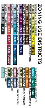
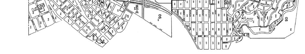
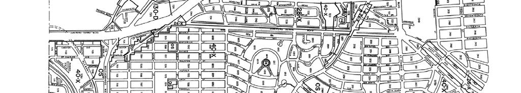
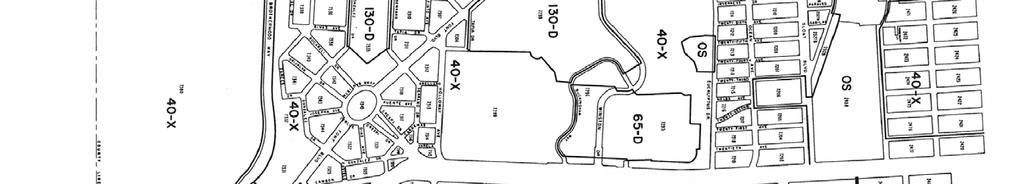
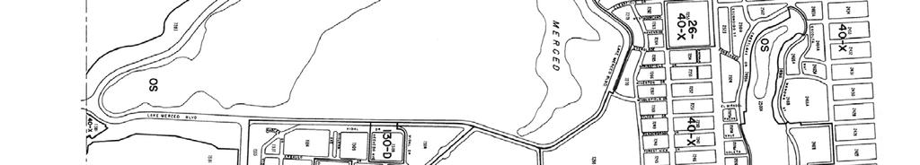
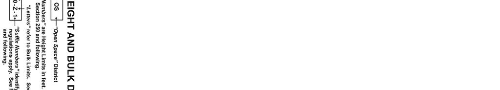
5 It should be noted that the project site is not within the California Coastal Zone and therefore is not subject to the California Coastal Act. 1 There are no other state or regional land use plans that are applicable to the project site. San Francisco General Plan The San Francisco General Plan contains a comprehensive set of goals, objectives, policies, and programs to guide future growth and development in the City and County of San Francisco. The manner in which the general goals in the San Francisco General Plan are to be attained is set forth through a statement of objectives and policies in a series of elements. The General Plan currently contains the following elements: Housing, Commerce and Industry, Recreation and Open Space, Community Facilities, Transportation, Community Safety, Air Quality, Environmental Protection, Urban Design and Arts. As the General Plan does not contain an element addressing Land Use, there are no land use designations provided for in this document. The General Plan also contains area plans that identify specific localized goals and objectives for a neighborhood or district of the city. However, the SF State campus is not addressed in any of the area plans. Of particular relevance to the SF State campus, the Community Facilities Element of the General Plan contains Objective 9, which states San Francisco s intention to assure that institutional uses are located in a manner that will enhance their efficient and effective use. Further, Policy 9.1 indicates that institutional uses should be located according to the Institutional Facilities Plan, which is provided in the General Plan. The SF State campus is located in accordance with this plan. San Francisco Planning Code The SF State campus site is primarily located within the Public (P) Zoning District, according to the San Francisco Planning Code. P Districts refer to land owned by a governmental agency that is in public use. Exceptions to this include the recently acquired UPN property and the SF State Foundation s UPS property. The UPS property is designated Residential Mixed Districts, Low Density (RM-1) and the UPN property is designated RM-1 and Residential Mixed Districts, High Density (RM-4). The School of the Arts (SOTA) site is already within a P District, as it was previously a school site. The SF State campus is within San Francisco s 40-X, 65-D, and 130-D Height and Bulk Districts. 2 The western half of the campus is within the 130-D District and the eastern half is within the 40-X and 65-D Districts (see Figure 4.8-2, San Francisco Zoning Districts and Figure 4.8-3, San Francisco Height and Bulk Districts). Properties to the north of the campus are zoned P District at the location of Lowell High School and Community Business District (C-2), at the location of the Stonestown shopping center. Residential properties to the south of the campus are zoned RM-1 and RM-4 in the Villas Parkmerced residential areas, and residential properties to the east are zoned Residential, House Districts, One Family (Detached Dwellings) (RH-1[D]) and RH-1. The open space lands to the west are zoned P District. Surrounding Height and Bulk Districts are 28-X, 40-X, 65-D, and 130-D. The Villas Parkmerced neighborhood to the south is within the 130-D and 40-X Districts, the Ingleside neighborhood to the east 1 The Bay Area Air Quality Management Plan is addressed in Section 4.2, Air Quality. The Water Quality Control Plan (or Basin Plan) for the Regional Water Quality Control Board San Francisco Bay Region is addressed in Section 4.7, Hydrology and Water Quality. 2 The number refers to the building height limit and the letter refers to the building bulk limits. 4.8_Land Use.doc\30-JAN-07\ San Francisco State University
6 is within the 28-X District, and Stonestown shopping center and Lowell High School are within the 65-D and 40-X Districts, respectively (see Figure 4.8-2, San Francisco Zoning Districts and Figure 4.8-3, San Francisco Height and Bulk Districts) Impacts and Mitigation Measures Standards of Significance The following standards of significance are based on Appendix G of the CEQA Guidelines. For the purposes of this EIR, the project will have a significant impact with regard to land use if it will: Physically divide an established community. Conflict with any applicable land use plan, policy, or regulation of an agency with jurisdiction over the project adopted for the purpose of avoiding or mitigating an environmental effect. Conflict with any applicable habitat conservation plan or natural community conservation plan. All of these CEQA standards of significance are addressed in this section, except the last standard addressing applicable habitat conservation plans. This standard is addressed in Section 4.3, Biological Resources Analytical Method This analysis compares potential impacts of the proposed Campus Master Plan to the standards of significance stated above to determine the level of significance of the impact under CEQA. If an impact is determined to be significant, the analysis identifies feasible mitigation measures that will eliminate the impact or reduce it to a less-than-significant level. If the impact cannot be reduced to a less-thansignificant level after implementation of feasible mitigation measures, then the impact is considered significant and unavoidable. The methodology applied to assess and evaluate land use impacts in the EIR is based on information obtained from a site reconnaissance, review of existing and proposed campus land uses and development, review of existing surrounding land uses and development, review of applicable elements in the San Francisco General Plan, and review of applicable zoning and height and bulk districts in the San Francisco Planning Code. As indicated above, SF State is not subject to local land use regulations. Nevertheless, such local planning documents are of interest to the SF State campus because campus development and local development are coincident. Moreover, SF State maintains cooperative relations with local governments regarding planning and land use issues to assure that mutual interests are addressed. For the purposes of coordination between SF State and the City and County of San Francisco, this EIR provides a review of the general conformance of the proposed Campus Master Plan to the relevant portions of the San Francisco General Plan and San Francisco Planning Code. The focus of this analysis is to identify any potentially significant land use impacts that could occur adjacent to the campus on land under the jurisdiction of the City and County of San Francisco. Campus Master Plan Draft EIR _Land Use.doc\30-JAN-07\
7 Campus Master Plan Impacts and Mitigation Measures Impact LU-1: Significance: Mitigation LU-1: Residual Significance: Growth and development under the proposed Campus Master Plan will not physically divide an established community. Less than significant Mitigation not required Less than significant Planned growth and development anticipated under the proposed Campus Master Plan will replace old buildings, increase the overall density of development through new construction, and increase enrollment and employment on the SF State campus. This growth and development will occur mostly on the existing 134-acre campus that is already developed, which includes the recently acquired UPN property in the northern part of the campus. Additionally, the proposed Campus Master Plan anticipates that the UPS property along Holloway Avenue now owned by the SF State Foundation will be transferred to SF State and that the SOTA site will be purchased by SF State from the SFUSD. This will expand the campus boundaries to the south, as shown in Figure 3-1, Campus Master Plan Boundary. This expansion of the campus boundaries will not physically divide an established community. Rather, implementation of the proposed Campus Master Plan in these areas will result in continued use of the UPS property for residential purposes and continued use of the SOTA site for educational purposes. The UPS property is currently part of the larger Villas Parkmerced residential complex to the south, which is occupied by members of both the SF State population and the general public. These units will be turned over for SF State uses only as current tenants naturally vacate their units. While a portion of these units will be redeveloped for higher-density housing (see Figure 3-6, Master Plan Diagram), once this land is transferred from the SF State Foundation to SF State, this housing will be constructed within a similar lot pattern as the existing development and will be located on the northern edge of the Villas Parkmerced residential complex. Therefore, this redeveloped housing will not physically divide the Villas Parkmerced residential complex. Moreover, roadway connections between Holloway Avenue, Font Boulevard, and 19 th Avenue in the vicinity of the UPS property and the SOTA site will remain unchanged, allowing for continued access through or to these properties. Overall, the proposed Campus Master Plan will not physically divide an established community. The impact is therefore considered less than significant. Impact LU-2: Significance: Mitigation LU-2: Residual Significance: Growth and development under the proposed Campus Master Plan will not conflict with applicable land use plans, policies, or regulations of an agency with jurisdiction over the project adopted for the purposes of avoiding or mitigating an environmental effect. Less than significant Mitigation not required Less than significant 4.8_Land Use.doc\30-JAN-07\ San Francisco State University
8 The proposed Campus Master Plan, if adopted, will become the applicable campus land use plan. The California State University System is the only agency with land use jurisdiction over campus projects. Thus, campus development that is consistent with the adopted proposed Campus Master Plan will not have land use impacts under this CEQA threshold of significance. Therefore the impact is less than significant. As indicated above, SF State is not subject to local land use regulations. Nevertheless, such local planning documents are of interest to the SF State campus because campus development and local development are coincident. Moreover, SF State maintains cooperative relations with local governments regarding planning and land use issues to assure that mutual interests are addressed. For the purposes of coordination between SF State and the City and County of San Francisco, this EIR provides a review of the general conformance of the proposed Campus Master Plan to the relevant portions of the San Francisco General Plan and San Francisco Planning Code. The focus of this analysis is to identify any potentially significant land use impacts that could occur adjacent to the campus on land under the jurisdiction of the City and County of San Francisco. As shown in the evaluation below, the proposed Campus Master Plan for SF State generally conforms to relevant local land use plans. San Francisco Zoning Districts As stated in the Environmental Setting section, the vast majority of the SF State campus planning area is zoned Public in the San Francisco Planning Code, which is consistent with the operation of a college campus on this site. This is also the case for the SOTA site, currently under negotiation for purchase by SF State. The use of the SOTA site for campus educational uses, as contemplated by the proposed Campus Master Plan, will be consistent with the existing zoning for the site (i.e., Public). Therefore, if this property were ultimately purchased by SF State, the proposed academic use on the site will be compatible with the existing zoning. The UPS and UPN properties, however, are zoned RM-1 and RM-4 (See Figure 4.8-2, San Francisco Zoning Districts). It is expected that during the next Planning Code update process, the City and County of San Francisco will re-zone these newly acquired properties for campus uses. This re-zoning is not necessary for the implementation of the proposed Campus Master Plan to proceed on lands owned by SF State, as SF State is exempt from local land use regulations and therefore San Francisco s zoning districts are not applicable. Re-zoning of the portion of UPS anticipated for redevelopment by the proposed Campus Master Plan will also not be required, as this property will not be developed until it is ultimately transferred to SF State ownership. While rezoning will not be required for the implementation of the proposed Campus Master Plan to proceed, UPS and UPN will continue to be used for housing under the proposed Campus Master Plan. Existing housing in these areas to remain will continue to be consistent with the existing use and the existing zoning for these sites. Although the proposed redevelopment of a portion of UPN and UPS will be somewhat denser than will be allowed under the RM-1 District on those project sites, the density will be less than is allowed in the adjacent RM-4 Districts that exist in UPN and in the adjacent Villas Parkmerced. Additionally, this increase in density is consistent with housing initiatives that San Francisco is pursuing under its Citywide Action Plan (CAP). The CAP promotes housing by increasing densities in areas well served by transit, which is the case at the SF State campus (See Section 4.10, Population and Housing for additional information about CAP). Therefore, the proposed redevelopment Campus Master Plan Draft EIR _Land Use.doc\30-JAN-07\
9 of a portion of UPS and UPN will generally conform with the existing use and zoning in this area and will not otherwise result in a significant land use impact, such as compatibility with existing adjacent uses, as further described below. San Francisco Height and Bulk Limits As indicated in the Environmental Setting section, the SF State Campus is within San Francisco s 40-X, 65-D, and 130-D Height and Bulk Districts. The 130-D District applies to the western half of the campus and the 40-X and 65-D Districts apply to the eastern half of the campus (see Figure 4.8-3, San Francisco Height and Bulk Districts). The general conformance of anticipated buildings identified in the proposed Campus Master Plan with San Francisco height limits is further described below. Bulk limits are not evaluated, as project-specific design information for proposed buildings is not available at this stage in the planning process. The proposed Campus Master Plan height limits maintain a consistent scale on the campus, relate to existing buildings where appropriate, and allow iconic buildings such as the Student Center to maintain their unique identity. The proposed Campus Master Plan (see Figure 3-7, Building Height Limits) indicates that new academic buildings around the Quad and new residential buildings in UPS will maintain a 50-foot height limit. While this limit is somewhat higher than the San Francisco s 40-foot height limit for this portion of the campus, it is consistent with other existing campus development in this portion of the campus. Additionally, while the proposed redevelopment of a portion of UPS will result in somewhat taller buildings than San Francisco s 40-foot height limit will allow, the new buildings will be substantially lower than is allowed in the adjacent 130-D Districts that exist elsewhere in Villas Parkmerced. Additionally, providing for taller building heights in order to increase density is consistent with housing initiatives that San Francisco is pursuing under its Citywide Action Plan (CAP). The CAP promotes housing by increasing densities in areas well served by transit, which is the case at the SF State campus, by using specific strategies such as increasing height limits (see Section 4.10, Population and Housing for additional information about CAP). Therefore, the proposed redevelopment of a portion of UPS will generally conform with the existing use and height districts in this area and will not otherwise result in a significant land use impact. It should also be noted that a 50-foot height limit will also apply in UPN, which is consistent with San Francisco s 65-foot height limit in this portion of the campus. The height limit will be 70 feet along Centennial Walk and in Centennial Village consistent with the existing Humanities and Village buildings. This limit will also apply to the Gym/Recreation-Wellness Center. The 70-foot limit is lower than San Francisco s 130-foot height limit for the western portion of the campus. The 70-foot limit will also apply along most of 19th Avenue to reinforce the campus s urban frontage. While this limit is higher than San Francisco s 40-foot height limit for this portion of the campus, it is consistent with or lower than existing campus development in that area, such as Thornton and Hensill Halls. Moreover, new development along 19 th Avenue will not otherwise result in a significant land use impact, such as compatibility with existing adjacent uses, as further described below. A 100-foot limit will apply to the Hotel tower and high-volume spaces in the Creative Arts buildings. This limit for the Creative Arts buildings is consistent with the San Francisco s 130-foot height limit for 4.8_Land Use.doc\30-JAN-07\ San Francisco State University
10 this portion of the campus. It is also consistent with the building heights associated with the Villas Parkmerced towers to the south. While the 100-foot limit for the Hotel will be higher than San Francisco s 40-foot and 65-foot height limits for this portion of the campus, it is consistent with existing campus development in that area, such as Thornton and Hensill Halls. Moreover, this facility will not otherwise result in a significant land use impact, such as compatibility with existing adjacent uses, as further described below. Land Use Compatibility The proposed Campus Master Plan will not conflict with local land use plans, such that it will result in the development of land uses that are substantially incompatible with adjacent uses. SF State is already a fully developed campus that is located on land designated for institutional uses by the San Francisco General Plan. Moreover, the proposed Campus Master Plan will generally conform with local land use plans, as indicated above. While the campus will become somewhat denser with development under the proposed Campus Master Plan, the pattern and types of campus development will generally be maintained. Therefore, surrounding land uses will continue to exist adjacent to a fully developed campus with proposed new and replacement buildings that are generally similar to those that currently exist. While the proposed semi-public uses and the neighborhood retail uses are new to the campus, none of these or other proposed campus uses will generate substantial noise, air emission, odors, or hazardous or toxic materials, such that substantial incompatibilities with existing uses adjacent to the campus will occur. The impacts of proposed development under the proposed Campus Master Plan on air quality and noise are specifically addressed in Section 4.2, Air Quality and Section 4.9, Noise. Members of the Villas Parkmerced neighborhood have indicated that existing and planned campus uses are incompatible with the existing Villas Parkmerced neighborhood and likely other surrounding neighborhoods. It appears as though this incompatibility is based primarily on concerns about existing overflow parking and associated traffic in that and other neighborhoods that surround the campus. Other primary concerns expressed relate to the presence of SF State students living in the Villas Parkmerced neighborhood and associated nighttime noise and security issues, and a concern relative to the proposed retail development along Holloway Avenue. With respect to parking in the residential neighborhoods near the campus, the Campus Master Plan acknowledges that SF State affiliates currently park in residential areas, and that if the price of on-campus parking is not managed carefully, additional SF State affiliates could potentially choose to park offcampus in residential areas. To address this, the parking strategy in the Campus Master Plan has been designed to avoid sharp increases in the cost of parking on campus that could occur if too much parking is provided on the campus and to improve transit use. Additionally, SF State representatives will participate in local planning efforts relating to on-street parking programs in the vicinity of the campus. This involvement will aim to ease local neighbors concerns and ensure that changes in local parking permit programs are implemented in an appropriate manner. See Impact TRA-5 in Section 4.11, Transportation, Circulation, and Parking for additional information. The proposed Campus Master Plan allows for limited neighborhood serving retail (e.g., corner convenience store or eating place) along Holloway Avenue and not the types of retail that would attract non-local persons or vehicular traffic to this area. Additionally, in the short-term, the provision of new campus housing in UPN and UPS under the proposed Campus Master Plan will likely allow more Campus Master Plan Draft EIR _Land Use.doc\30-JAN-07\
11 students to live on campus to the extent that they choose to do so, which could potentially reduce the student presence in Villas Parkmerced. It should also be noted that the SF State population living in new residential development in UPS and UPN will be required to adhere to strict campus housing policies regarding misbehavior and nighttime noise. Moreover, under Title 5, Section of the California Code of Regulations, and CSU Executive Order No. 970, the campus will also implement disciplinary actions against any student for campus-related offenses. Therefore, implementation of existing regulations and campus policies will minimize issues related to nighttime noise and security due to student activities in UPN and UPS. Please also see Section 4.12, Utilities and Services for a discussion of the effects of the proposed Campus Master Plan on police services. In summary, for the above reasons, the development of campus uses under the proposed Campus Master Plan will not conflict with local land use plans Cumulative Impacts and Mitigation Measures Impact LU-3: Significance: Mitigation LU-3: Residual Significance: Development under the proposed Campus Master Plan, together with other growth in the vicinity, will not result in the development of land uses that are substantially incompatible with existing adjacent land uses or planned uses in the southwestern portion of San Francisco. Less than significant Mitigation not required Less than significant As previously discussed in Impact LU-2, the proposed project will not introduce any land uses on the main campus that will be incompatible with surrounding land uses in San Francisco. Lands designated for development in local land use plans in the vicinity of the campus are already mostly developed. Therefore, the majority of future development in the area is expected to consist of redevelopment of existing properties, such as is currently proposed at 77 Cambon Drive, located south of the campus, and at 473 Eucalyptus Drive, located north of the campus. A very limited amount of new development on undeveloped parcels may also occur in the vicinity of campus, such as is proposed at 800 Brotherhood Way, located south of the campus. Such development will be expected to be in general conformance with local land use plans and therefore will not likely result in substantial incompatibilities with surrounding land uses. As a result, cumulative development in the vicinity of the SF State campus in the accordance with the local land use plans will not be expected to introduce land uses that will be substantially incompatible with the proposed campus development or other adjacent development. In conclusion, neither development on campus, nor reasonably foreseeable future development within the southwestern portion of San Francisco, will result in a significant cumulative impact associated with substantially incompatible development. Therefore, the potential cumulative land use impact will be less than significant. The impacts of cumulative development on air quality, noise, and traffic, circulation, and parking are addressed in Section 4.2, Air Quality, Section 4.9, Noise, and Section 4.11, Traffic, Circulation, and Parking. 4.8_Land Use.doc\30-JAN-07\ San Francisco State University
12 4.8.3 References City and County of San Francisco, Planning Department, San Francisco General Plan, Air Quality Element. City and County of San Francisco, Planning Department, San Francisco General Plan, Arts Element, City and County of San Francisco, Planning Department, San Francisco General Plan, Commerce and Industry Element, City and County of San Francisco, Planning Department, San Francisco General Plan, Community Facilities Element, City and County of San Francisco, Planning Department, San Francisco General Plan, Community Safety Element, City and County of San Francisco, Planning Department, San Francisco General Plan, Environmental Protection Element, City and County of San Francisco, Planning Department, San Francisco General Plan, Housing Element, City and County of San Francisco, Planning Department, San Francisco General Plan, Recreation and Open Space Element, City and County of San Francisco, Planning Department, San Francisco General Plan, Transportation Element, City and County of San Francisco, Planning Department, San Francisco General Plan, Urban Design Element, City and County of San Francisco, Planning Department, San Francisco General Plan, Western Shoreline Plan. City and County of San Francisco, Planning Department, San Francisco Planning Code, City and County of San Francisco, Planning Department, San Francisco Municipal Code Zoning Maps, Campus Master Plan Draft EIR _Land Use.doc\30-JAN-07\
13
14
15
4.8 LAND USE AND PLANNING
 4.8 LAND USE AND PLANNING 4.8.1 INTRODUCTION This section describes existing and planned land uses at the Hayward campus and analyzes the impact of implementation of the proposed Master Plan on land uses
APPENDIX A NOTICE OF PREPARATION
 APPENDIX A NOTICE OF PREPARATION PROJECT DESCRIPTION Project Location The existing 134-acre San Francisco State University (SFSU) campus is located in the southwestern corner of the City and County of
4.1 AESTHETICS Environmental Setting
 4.1 AESTHETICS This section of the Focused Tiered Final EIR presents potential aesthetic impacts of the Creative Arts and Holloway Mixed-Use Project (Project). Preparation of this Focused Tiered Final
3.10 LAND USE SETTING PROJECT SITE EXISTING LAND USE DESIGNATIONS AND ZONING. General Plan Land Use Designations.
 This section of the Draft EIR addresses the existing land uses on and adjacent to the project site and discusses the potential impacts of the proposed project on existing land uses. Key issues addressed
Project Description...3-1
 TABLE OF CONTENTS Chapter 3 Project Description...3-1 3.1 Introduction...3-1 3.2 Project Location and Vicinity...3-2 3.3 Existing Site Conditions...3-2 3.3.1 Built Environment...3-2 3.3.2 Environmental
TABLE OF CONTENTS. Tables Table UC Davis Park and Open Space Resources
 TABLE OF CONTENTS 4.13 Recreation... 4.13-1 4.13.1 Environmental Setting... 4.13-1 4.13.2 Impacts and Mitigation Measures... 4.13-4 4.13.3 References... 4.13-8 Tables Table 4.13-1 UC Davis Park and Open
Moreno Valley College: Conceptual Master Planning - Site Analysis Lasselle Street, Moreno Valley, CA 92551
 Master Plan Architect School Name Moreno Valley College District Riverside Community College District Architecture and Urban Design 5898 Blackwelder Street Ground Floor Culver City, CA 90232 T: 310.559.5720
San Francisco State University Campus Master Plan. Chapter 7. Urban Design Plan
 San Francisco State University Campus Master Plan Chapter 7. 7. Defining Elements The urban design plan for the campus, described in the accompanying Master Plan Buildout diagram, expands upon the framework
4. ENVIRONMENTAL IMPACT ANALYSIS 7. LAND USE AND PLANNING
 4. ENVIRONMENTAL IMPACT ANALYSIS 7. LAND USE AND PLANNING 4.7.1 INTRODUCTION The following analysis discusses the consistency of the Proposed Project with the corresponding land use and zoning designations
~P'~'~; SAN FRANCISCO
 ~o counr~, ~P'~'~; SAN FRANCISCO ~'.~ PLANNING DEPARTMENT a 2 757 O~~~S 0 Case No.: Project Address: Zoning: Certificate of Determination COMMUNITY PLAN EVALUATION UMU (Urban Mixed Use) District 58-X Height
No comments related to land use and planning issues were received in response to the Notice of Preparation.
 4.8 LAND USE AND PLANNING This section analyzes the impacts relative to land use and planning that would occur as a result of implementation of the proposed Facilities Master Plan (proposed project). This
Planning Commission Staff Report June 5, 2008
 Owner/Applicant Taylor Village Sacramento Investments Partners, LP c/o Kim Whitney 1792 Tribute Road #270 Sacramento, CA 95815 Staff Recommendation Planning Commission Staff Report Project: File: Request:
Technical Appendix L, University Community Plan Town Center
 Technical Appendix L, University Community Plan Town Center Table of Contents L.1 Executive Summary L.2 Merced County University Community Plan, 2004 Findings L.2.1 Visioning L.2.2 UCP Goals, Objectives
GENERAL PLAN CONSISTENCY ANALYSIS
 GENERAL PLAN CONSISTENCY ANALYSIS Prepared by Planning Staff 10/28/2013 APPLICABLE GOALS, POLICIES AND PROGRAMS FROM the LAND USE CHAPTER Goal LU-1 Policy LU-1.1 Policy LU-1.2 Goal LU-2 Protect the character
Venice Pumping Plant Dual Force Main Project Draft EIR
 City of Los Angeles 5.9 LAND USE PLANS 5.9.1 Environmental Setting Venice Pumping Plant Dual Force Main Project Draft EIR The Project lies within the bounds of Los Angeles County and the City of Los Angeles.
Nob Hill Pipeline Improvements Project EIR
 Section 3.1 Aesthetics This section addresses the visual aspects that may affect the views experienced by the public, including the potential to impact the existing character of each area that comprises
Certificate of Determination EXEMPTION FROM ENVIRONMENTAL REVIEW
 / - \ 11ff SAN FRANCISCO PLANNING DEPARTMENT Certificate of Determination EXEMPTION FROM ENVIRONMENTAL REVIEW 1650 Mission St. Suite 400 San Francisco, CA 94103-2479 Case No.: Reception: Project Address:
3.0 PROJECT DESCRIPTION
 3.0 PROJECT DESCRIPTION 3.1 BACKGROUND Under California law (Government Code Section 65300 et seq.), every city and county is required to have a general plan. The general plan is to be comprehensive and
APPENDIX F. Mitigation Monitoring and Reporting Program
 APPENDIX F Mitigation Monitoring and Reporting Program APPENDIX F MITIGATION MONITORING AND REPORTING PROGRAM This Mitigation Monitoring and Reporting Program (MMRP) for the Creative Arts and Holloway
SAN FRANCISCO. x ~ OT`s 0~5` PLANNING DEPARTMENT. Certificate of Determination COMMUNITY PLAN EVALUATION PROJECT DESCRIPTION CEQA DETERMNATION
 y;~~~ counr~on u "'s' 9z x ~ OT`s 0~5` SAN FRANCISCO PLANNING DEPARTMENT COMMUNITY PLAN EVALUATION Case No.: Project Address: Zoning: RTO-M (Residential Transit Oriented-Mission) Use District Calle 24
UNIVERSITY OF MICHIGAN:
 Chapter Eight UNIVERSITY OF MICHIGAN: North Campus I. Introduction The University of Michigan currently owns approximately 800 acres of land in the northeast section of Ann Arbor. North Campus refers to
Notice of Preparation and Notice of Public Scoping Meeting. At Dublin Project
 Notice of Preparation and Notice of Public Scoping Meeting Date January 17, 2018 To Project Title Project Application Number Project Location Project Applicant Contact For questions or submitting comments.
SAN FRANCISCO PLANNING DEPARTMENT
 PLANNING DEPARTMENT Certificate of Determination EXEMPTION FROM ENVIRONMENTAL REVIEW Case No.: Project Address: Zoning: UMU (Urban Mixed Use) Zoning District 68-X Height and Bulk District Life Science
12.0 LAND USE AND PLANNING
 This section describes the existing and proposed land uses and land use designations on each of the project sites and surrounding properties, and analyzes the potential for the project to conflict with
ENVIRONMENTAL SETTING
 II. ENVIRONMENTAL SETTING EXISTING CONDITIONS The 208.87-acre Project site is located in the western portion of the City (refer to Figures II-1 and II-2). The Project site comprises Assessor s Parcel Number
4 C OMMUNITY D ISTRICTS
 4 C OMMUNITY D ISTRICTS N ew development in the Area will include many different types of land uses, including a destination retail area that attracts people from all over the region; recreation opportunities
Appendix E Section 4(f) Evaluation
 Evaluation") Appendix E Section 4(f) Evaluation Appendix E Draft Section 4(f) Evaluation E.1 Introduction This appendix addresses a federal regulation known as Section 4(f), which protects parks, recreation areas,
Appendix E Section 4(f) Evaluation Appendix E Draft Section 4(f) Evaluation E.1 Introduction This appendix addresses a federal regulation known as Section 4(f), which protects parks, recreation areas,
Executive Summary General Plan Amendment Initiation
 Executive Summary General Plan Amendment Initiation HEARING DATE: AUGUST 6, 2015 Date: July 30, 2015 Case No.: 2011.0409PCA Project Address: 925 Mission Street and various parcels (aka 5M ) Existing Zoning:
[PLANNING RATIONALE] For Site Plan Control and Lifting of Holding Zone By-Law 101 Champagne Avenue. May 23, 2014
![[PLANNING RATIONALE] For Site Plan Control and Lifting of Holding Zone By-Law 101 Champagne Avenue. May 23, 2014](/thumbs/75/71599615.jpg "[PLANNING RATIONALE] For Site Plan Control and Lifting of Holding Zone By-Law 101 Champagne Avenue. May 23, 2014") [PLANNING RATIONALE] For Site Plan Control and Lifting of Holding Zone By-Law 101 Champagne Avenue May 23, 2014 Contents 1.0 Introduction... 2 2.0 Site Context... 2 2.1 Adjacent Uses... 2 Figure 1: Site
[PLANNING RATIONALE] For Site Plan Control and Lifting of Holding Zone By-Law 101 Champagne Avenue May 23, 2014 Contents 1.0 Introduction... 2 2.0 Site Context... 2 2.1 Adjacent Uses... 2 Figure 1: Site
3.10 Land Use and Planning
 3.10 This section describes the regulatory and environmental setting for land use and planning in the program and individual project areas. It also describes impacts on land use and planning that could
The principal elements of the NTC Strategic Vision plan are as follows.
 The proposed project would improve the NTC site plan, circulation, visitor amenities, and landscaping, and would include construction of two new stadiums to replace the existing Louis Armstrong Stadium
CHAPTER 3 PROJECT DESCRIPTION
 CHAPTER 3 PROJECT DESCRIPTION 3.1 PROJECT OVERVIEW San Francisco State University (SF State) proposes to develop the Creative Arts and Holloway Mixed-Use Project (Project) in the southern portion of the
City Of Sparks Planning Commission Item
 Page 1 of 12 City Of Sparks Planning Commission Item Meeting Date: May17, 2012 Subject: PCN12009, Public Hearing, Consideration and possible action on a Master Plan Amendment and Rezoning request to change
4.8 LAND USE ANALYTICAL METHODS
 This chapter describes existing land uses in each of the 2020 LRDP Land Use Zones and evaluates the potential for development under the 2020 LRDP to affect those land uses. This chapter also examines the
Planning & Zoning Commission Staff Report
 Planning & Zoning Commission Staff Report Meeting Date: May 26, 2015 Drafted by: Katherine Harrison-Rogers CASE # Z2886 PROJECT NAME: APPLICANT/ REPRESENTATIVE: Shawna Runyan PROPERTY OWNER: 1840 (previously
UNIVERSITY OF CALIFORNIA, SAN DIEGO
 UNIVERSITY OF CALIFORNIA, SAN DIEGO BERKELEY DAVIS IRVINE LOS ANGELES MERCED RIVERSIDE SAN DIEGO SAN FRANCISCO SANTA BARBARA SANTA CRUZ CAMPUS PLANNING 9500 GILMAN DRIVE # 0074 TEL: (858) 534 6515 LA JOLLA,
A. OVERVIEW OF ENVIRONMENTAL SETTING
 IV. A. OVERVIEW OF The proposed site is comprised of three parcels totaling approximately 4.24 acres, situated southwesterly of the intersection of Weyburn and Tiverton Avenues. Parcel A is 2.72 acres
LAND USE AMENDMENT DOWNTOWN COMMERCIAL CORE (WARD 7) MACLEOD TRAIL SE AND 5 AVENUE SE BYLAW 254D2017
 MACLEOD TRAIL SE AND 5 AVENUE SE BYLAW 254D2017") Page 1 of 10 EXECUTIVE SUMMARY This Land Use Amendment application seeks to redesignate a full downtown block (currently the YWCA site) from a Direct Control based on the CM-2 District (Land Use Bylaw
Page 1 of 10 EXECUTIVE SUMMARY This Land Use Amendment application seeks to redesignate a full downtown block (currently the YWCA site) from a Direct Control based on the CM-2 District (Land Use Bylaw
NOTICE OF PREPARATION OF ENVIRONMENTAL IMPACT REPORT
 NOTICE OF PREPARATION OF ENVIRONMENTAL IMPACT REPORT TO: State Clearinghouse, Responsible and Trustee Agencies, and Other Interested Parties DATE: May 18, 2017 SUBJECT: Notice of Preparation of Environmental
PLANNING COMMISSION. Submitted
 PLANNING COMMISSION City Hall 1275 Main Street El Centro, CA 92243 Submitted PLANNING COMMISSION ACTION ITEM (1844) Meeting: 05/10/16 12:00 AM Department: Community Development Category: Public Hearing
Staff Report and Recommendation
 Community Planning and Development Planning Services 201 W. Colfax Ave., Dept. 205 Denver, CO 80202 p: 720.865.2915 f: 720.865.3052 www.denvergov.org/cpd TO: City Council Neighborhoods and Planning Committee
KANATA CENTRUM 255 KANATA AVENUE OFFICIAL PLAN AMENDMENT ZONING BY-LAW AMENDMENT
 KANATA CENTRUM 255 KANATA AVENUE OFFICIAL PLAN AMENDMENT ZONING BY-LAW AMENDMENT JUNE 2015 PREPARED BY: FOTENN Consultants Inc. 223 Mcleod Street Ottawa, ON K2P OZ8 (613) 730-5709 PREPARED FOR: Kanata
NEIGHBORHOOD 7: FEE LANE AREA. Aerial View of Briscoe and McNutt Dormitories
 NEIGHBORHOOD 7: FEE LANE AREA Aerial View of Briscoe and McNutt Dormitories Fee Lane Area Map Briscoe Dormitory 278 neighborhoods NEIGHBORHOOD 7: FEE LANE AREA EXISTING CHARACTER The Fee Lane Area neighborhood
4.10 LAND USE AND PLANNING
 4.10 LAND USE AND PLANNING 4.10.1 INTRODUCTION This section considers the potential effects of the proposed New Student Housing Project (proposed project) relative to land use and planning. 4.10.2 METHODOLOGY
IV.B. VISUAL RESOURCES
 IV.B. VISUAL RESOURCES ENVIRONMENTAL SETTING Existing Visual Character Project Site The project site is located at 17331-17333 Tramonto Drive in the Pacific Palisades community of the City of Los Angeles
Table of Contents G.1.a Water Resources - Surface Water - Drainage
 Table of Contents G.1.a Water Resources - Surface Water - Drainage 1. INTRODUCTION... 1335 2. ENVIRONMENTAL SETTING... 1335 a. Regional Hydrology... 1335 b. Local Hydrology... 1337 c. On-site Hydrology...
SPECIFIC PLAN Requirements
 CITY OF LANCASTER PLANNING DEPARTMENT 44933 Fern Avenue, Lancaster, California 93534 (661) 723-6100 SPECIFIC PLAN Requirements Purpose The purpose of a specific plan is to provide for the logical development
CHAPTER ADDITIONAL REQUIREMENTS IN THE NC, NEIGHBORHOOD COMMERCIAL ZONE
 CITY OF MOSES LAKE MUNICIPAL CODE CHAPTER 18.31 ADDITIONAL REQUIREMENTS IN THE NC, NEIGHBORHOOD COMMERCIAL ZONE Sections: 18.31.010 Purpose 18.31.020 Minimum Lot Area 18.31.030 Setbacks 18.31.040 Maximum
Review of Opportunity Area C Draft Comprehensive Plan and Draft BOS Follow-On Motions. Special Working Group Meeting March 4, 2015
 Review of Opportunity Area C Draft Comprehensive Plan and Draft BOS Follow-On Motions Special Working Group Meeting March 4, 2015 The slides that follow identify where the draft Comprehensive Plan has
A Growing Community Rural Settlement Areas
 Town of Huntsville Official Plan Review - POLICY BACKGROUND PAPER A Growing Community Rural Settlement Areas BACKGROUND: In addition to the fully municipally-serviced Urban Settlement Area and the Hidden
Prepared by: Casey Kempenaar, Senior Planner
 CITY OF CITRUS HEIGHTS PLANNING DIVISION STAFF REPORT PLANNING COMMISSION MEETING September 13, 2017 Prepared by: Casey Kempenaar, Senior Planner REQUEST The applicant requests a Design Review Permit Modification
Executive Summary Planning Code and Zoning Map Amendments HEARING DATE: JUNE 18, 2015
 Executive Summary Planning Code and Zoning Map Amendments HEARING DATE: JUNE 18, 2015 Date: June 11, 2015 Project Name: Case Number: 2015-004022PCA MAP [Board File 150271] Initiated by: Supervisor Yee
17.11 Establishment of Land Use Districts
 17.11 Establishment of Land Use Districts 17.11.010 Purpose. To promote the health, safety, and general welfare of City residents and those who come to South Salt Lake to work, exchange commerce and recreate.
REPORT TO PLANNING COMMISSION
 CITY OF Meeting Date: October 25, 2011 Agenda Item: Community Development Department Planning Division P. O. Box 151560, San Rafael, CA 94915-1560 PHONE: (415) 485-3085/FAX: (415) 485-3184 Case Numbers:
NOTICE OF PREPARATION
 NOTICE OF PREPARATION To: Agencies, Organizations, and Interested Parties From: City of Alameda, Community Development Services Department Subject: Notice of Preparation of a Draft Environmental Impact
4.8 LAND USE AND PLANNING
 4.8 LAND USE AND PLANNING This section describes the existing land uses on the UCI campus and the surrounding communities and evaluates the potential for land use impacts associated with implementation
Planned Development Review Revisions (Project No. PLNPCM )
") Planned Development Review Revisions (Project No. PLNPCM2014-00139) Standard residential development Planned Development Example: Smaller lot sizes than what is allowed to create open space amenity. What
Planned Development Review Revisions (Project No. PLNPCM2014-00139) Standard residential development Planned Development Example: Smaller lot sizes than what is allowed to create open space amenity. What
14. INTERGOVERNMENTAL COORDINATION ELEMENT
 14. Introduction This Intergovernmental Coordination Element includes Goals, Objectives and Policies (GOP) that apply to the main campus and Alachua County Satellite Properties. The Intergovernmental Coordination
Be it enacted by the Town Board of the Town of Guilderland that the following new A (Transit Oriented Development (TOD) District) is adopted:
 District) is adopted:") Local Law No. 4 of 2018 (Adoption of 280-18A (Transit Oriented Development District) Be it enacted by the Town Board of the Town of Guilderland that the following new 280-18A (Transit Oriented Development
Local Law No. 4 of 2018 (Adoption of 280-18A (Transit Oriented Development District) Be it enacted by the Town Board of the Town of Guilderland that the following new 280-18A (Transit Oriented Development
12 Intergovernmental Coordination
 Intergovernmental Coordination Supporting Data The purpose of the Intergovernmental Coordination Element is to identify and resolve incompatible goals, objectives, policies and development proposed in
2.0 AREA PLANS. Lakeside Business District. Lakeside Business District Land Use Categories:
 Lakeside Business District Lakeside Business District Land Use Categories: Campus Commercial Campus Commercial means a mixture of uses which includes corporate offices, office parks, hotels, commercial,
CHARLES PUTMAN CHARLES PUTMAN AND ASSOCIATES, INC
 MEMORANDUM CHARLES PUTMAN & ASSOCIATES, INC. LAND DEVELOPMENT CONSULTANTS PLANNING ZONING PERMITTING 4722 NW Boca Raton Boulevard, Suite C-106 Boca Raton, Florida 33431 Phone: 561/994-6411 FAX: 561/994-0447
General Location Annex, Rezone & Preliminary Plat Lansdowne Addition, Unit Three
 NEWFOUNDLAND I-5 Agricultural District Subject Site SUNDANCE ANDERSON Single Family Residential CHRISTY PUD Agricultural District Highway Business General Location Annex, Rezone & Preliminary Plat Lansdowne
Gold Line Bus Rapid Transit Transit Oriented Development (BRTOD) Helmo Station Area Plan
 Helmo Station Area Plan") Appendix F Gold Line Bus Rapid Transit Transit Oriented Development (BRTOD) Helmo Station Area Plan Introduction and Purpose of the Plan The Gold Line Bus Rapid Transit facility is an eleven-mile dedicated
Appendix F Gold Line Bus Rapid Transit Transit Oriented Development (BRTOD) Helmo Station Area Plan Introduction and Purpose of the Plan The Gold Line Bus Rapid Transit facility is an eleven-mile dedicated
THE GEORGE WASHINGTON UNIVERSITY MOUNT VERNON CAMPUS
 THE GEORGE WASHINGTON UNIVERSITY MOUNT VERNON CAMPUS CAMPUS PLAN AMENDMENT AND FURTHER PROCESSING APPLICATION: PRE-HEARING SUBMISSION PELHAM REPLACEMENT PROJECT FILED WITH THE ZONING COMMISSION OF THE
Bourne Downtown Site Planning
 Prepared for: The Town of Bourne, MA In Cooperation with: Bourne Financial Development Corporation Prepared by:, Inc. June 24, 2009 Table of Contents Introduction and Summary... 1 Site Existing Conditions...
CAMPUS MASTER PLAN DRAFT PLAN UPDATE JANUARY
 NEW MEXICO HIGHLANDS UNIVERSITY CAMPUS MASTER PLAN DRAFT PLAN UPDATE JANUARY 27 2010 MASTER PLANNING GOALS TO BALANCE THE STRATEGIC GOALS OF THE UNIVERSITY WITH THE PHYSICAL CAMPUS through the assessment
Responses to Comments Received on the Notice of Preparation
 Received on the Notice of Preparation APPENDIX A RESPONSES TO COMMENTS RECEIVED ON THE NOTICE OF PREPARATION The Notice of Preparation and Draft Initial Study for the proposed 2003 LRDP were circulated
The impacts examined herein take into account two attributes of aesthetic values:
 IV. ENVIRONMENTAL IMPACT ANALYSIS This section addresses the potential impacts to views and aesthetics as a result of the proposed Project at the Project Site and the development scenarios analyzed for
Planning Commission Staff Report Agenda Item No. 4 March 7, 2019
 DEPARTMENT OF PUBLIC WORKS AND PLANNING STEEN E. WHITE, DIRECTOR Planning Commission Staff Report Agenda Item No. 4 March 7, 2019 SUBJECT: General Plan Conformity Application Clovis Unified School District
6. RECREATION AND OPEN SPACE ELEMENT
 6. RECREATION AND OPEN SPACE Introduction This Recreation and Open Space Element includes Goals, Objectives and Policies (GOP) that apply to the main campus in Gainesville and the Lake Wauburg Recreation
CHAPTER 2 SUMMARY 1. PROJECT SUMMARY DATA
 CHAPTER 2 SUMMARY This is an Initial Study format used to determine, pursuant to CEQA Guidelines Section 15177, whether a project 1) is within the scope of a Master EIR (MEIR), 2) may result in additional
SUBJECT: PREDEVELOPMENT PLAN REVIEW OF PROJECT LOCATED AT 2632 EAST WASHINGTON BOULEVARD ('ST. LUKE MEDICAL CENTER')
") TO: FROM: Honorable Mayor and City Council Planning & Community Development Department SUBJECT: PREDEVELOPMENT PLAN REVIEW OF PROJECT LOCATED AT 2632 EAST WASHINGTON BOULEVARD ('ST. LUKE MEDICAL CENTER')
TO: FROM: Honorable Mayor and City Council Planning & Community Development Department SUBJECT: PREDEVELOPMENT PLAN REVIEW OF PROJECT LOCATED AT 2632 EAST WASHINGTON BOULEVARD ('ST. LUKE MEDICAL CENTER')
Staff Report CONDITIONAL USE
 Staff Report PLANNING DIVISION COMMUNITY & ECONOMIC DEVELOPMENT To: From: Salt Lake City Planning Commission Daniel Echeverria, (801) 535-7165, daniel.echeverria@slcgov.com Date: May 21, 2015 Re: PLNPCM2015-00139
Edward R. Sajecki Commissioner of Planning and Building
 Corporate Report Clerk s Files Originator s Files CD.03.POR DATE: TO: FROM: SUBJECT: Chair and Members of Planning and Development Committee Meeting Date: February 27, 2012 Edward R. Sajecki Commissioner
IV. ENVIRONMENTAL IMPACT ANALYSIS H. LAND USE AND PLANNING
 IV. ENVIRONMENTAL IMPACT ANALYSIS H. LAND USE AND PLANNING ENVIRONMENTAL SETTING The Project Site is located in Los Angeles County, within the Hollywood Community Plan area of the City of Los Angeles.
2.4 FUTURE LAND USE ELEMENT Goals, Objectives and Policies
 GOAL 1: To create developmental patterns that direct future growth to appropriate areas on campus, in a manner that promotes the educational mission of the University, the protection of environmentally
TO: CITY COUNCIL DATE: MARCH 23,2009
 Report TO: CITY COUNCIL DATE: MARCH 23,2009 FROM: CITY MANAGER SUBJECT: MASTER DEVELOPMENT PLAN AMENDMENT FOR PASADENA CHRISTIAN SCHOOL AT 1515 NORTH LOS ROBLES AVENUE AND GENERAL PLAN AMENDMENT AND ZONE
4.1 LAND USE AND PLANNING EXISTING CONDITIONS REGULATORY BACKGROUND LAND USES IN THE PLAN AREA SURROUNDING LAND USES
 4.1 LAND USE AND PLANNING This section includes a description of the existing land use plans that apply to the Plan area and a description of existing land uses in the vicinity. It also includes an analysis
5.9 LAND USE Existing Conditions Historic Land Use Trends Existing Land Use Distribution
 5.9 LAND USE This section describes the existing land use pattern and land use planning/regulatory framework in the City of Fontana. It also evaluates potential long-term land use impacts such as physically
SECTION UNIFIED DEVELOPMENT ORDINANCE SECTION Part 1 Ordinance. ARTICLE 1 Zoning Districts
 SECTION 1-100 UNIFIED DEVELOPMENT ORDINANCE SECTION 1-300 Part 1 Ordinance SECTION 1-100. Introduction. ARTICLE 1 Zoning Districts Crystal Lake strives to maintain a balance of various land uses for a
12 January 12, 2011 Public Hearing APPLICANT: TAILWIND DEVELOPMENT GROUP,LLC PROPERTY OWNER: CITY OF VIRGINIA BEACH
 12 January 12, 2011 Public Hearing APPLICANT: TAILWIND DEVELOPMENT GROUP,LLC PROPERTY OWNER: CITY OF VIRGINIA BEACH STAFF PLANNER: Faith Christie REQUEST: Conditional Change of Zoning (from PD-H1 Planned
McDonald s Restaurant - Purcellville Town of Purcellville Special Use Permit Statement of Justification July 24, 2014
 Introduction / Written Statement McDonald s Restaurant - Purcellville McDonald s Corporation is proposing to redevelop the existing McDonald s eating establishment with a drive-through located at 121 N
DRAFT ETC Master Plan. Appendix D Land Uses and Demographics
 DRAFT ETC Master Plan Appendix D Land Uses and Demographics DRAFT ETC Master Plan Figure D 1. Existing Land Uses... D 3 Figure D 2. Future Land Uses... D 5 Figure D 3. Transportation Analysis Zones...
ENVIRONMENTAL INITIAL STUDY BERKELEY CITYWIDE POOLS MASTER PLAN
 ENVIRONMENTAL INITIAL STUDY FOR THE BERKELEY CITYWIDE POOLS MASTER PLAN CITY OF BERKELEY PARKS RECREATION AND WATERFRONT DEPARTMENT SEPTEMBER 1, 2009 ENVIRONMENTAL INITIAL STUDY BERKELEY CITYWIDE POOLS
PROJECT SUMMARY. University of California, Irvine Humanities Building. Project No FINAL INITIAL STUDY/MITIGATED NEGATIVE DECLARATION
 PROJECT SUMMARY University of California, Irvine Humanities Building Project No. 991077 FINAL INITIAL STUDY/MITIGATED NEGATIVE DECLARATION State Clearinghouse No. 2007011035 March 2007 Humanities Building
Request Conditional Rezoning (R-15 Residential to Conditional A-24 Apartment) Staff Recommendation Approval. Staff Planner Jimmy McNamara
 Staff Recommendation Approval. Staff Planner Jimmy McNamara") Applicant Franklin Johnston Group Management & Development, LLC Property Owner Virginia Wesleyan College Public Hearing July 12, 2017 City Council Election District Bayside Agenda Item 3 Request Conditional
Applicant Franklin Johnston Group Management & Development, LLC Property Owner Virginia Wesleyan College Public Hearing July 12, 2017 City Council Election District Bayside Agenda Item 3 Request Conditional
3.0 Cumulative Scenario and Methodology. 3.0 Cumulative Scenario and Methodology
 3.0 Cumulative Scenario and Methodology Under the CEQA Guidelines, a cumulative impact consists of an impact which is created as a result of the combination of the project evaluated in the environmental
Right-of-Way Acquisitions and Relocations Technical Memorandum
 Right-of-Way Acquisitions and Relocations Technical Memorandum Southeast Extension Project Lincoln Station to RidgeGate Parkway Prepared for: Federal Transit Administration Prepared by: Denver Regional
NOTICE OF PREPARATION
 NOTICE OF PREPARATION DATE: January 6, 2016 TO: LEAD AGENCY: Responsible Agencies, Organizations, and Interested Parties Contact: Tyler Barrington, Principal Planner Planning Department Community Development
LOS ANGELES CITY PLANNING DEPARTMENT STAFF REPORT
 LOS ANGELES CITY PLANNING DEPARTMENT STAFF REPORT LOS ANGELES CITY PLANNING COMMISSION CASE NO: CPC 2006-9374 CRA CEQA: Exempt DATE: December 21, 2006 Location: Valley Plaza and Laurel Plaza TIME: after
NEW CASTLE COUNTY S ZONING DISTRICTS
 NEW CASTLE COUNTY S ZONING DISTRICTS This is general information about New Castle County s zoning districts. The information included is by no means exhaustive or complete. Before designing plans to develop
Land Use element LAND USE POLICY AREAS ESTATE AND RURAL RESIDENTIAL AREAS/RURAL SHELDON AREA OLD TOWN ELK GROVE
 Land Use element Land Use is often considered the heart of the General Plan. The statement of future land uses describes how the City believes it should develop in the future where housing, shopping, open
CITY OF CYPRESS 5275 Orange Avenue Cypress, California (714) DESIGN REVIEW COMMITTEE PERMIT PROCESS
 DESIGN REVIEW COMMITTEE PERMIT PROCESS") CITY OF CYPRESS 5275 Orange Avenue Cypress, California 90630 (714) 229-6720 DESIGN REVIEW COMMITTEE PERMIT PROCESS 1. Discuss project with Planning staff to determine zoning regulations, any unusual characteristics
CITY OF CYPRESS 5275 Orange Avenue Cypress, California 90630 (714) 229-6720 DESIGN REVIEW COMMITTEE PERMIT PROCESS 1. Discuss project with Planning staff to determine zoning regulations, any unusual characteristics
COMMUNITY DEVELOPMENT SERVICES PLANNING AND BUILDING DEPARTMENT PLACERVILLE OFFICE:
 COMMUNITY DEVELOPMENT SERVICES PLANNING AND BUILDING DEPARTMENT http://www.edcgov.us/devservices/ PLACERVILLE OFFICE: LAKE TAHOE OFFICE: 2850 Fair Lane Court, Placerville, CA 95667 924 B Emerald Bay Rd.
ESTABLISH AN EFFICIENT TOWN CENTER
 ESTABLISH AN EFFICIENT TOWN CENTER 4 Overview Lisbon residents are proud of the history of Newent and at the same time recognize its current importance as a centralized location for a variety of municipal
PLANNING APPROVAL & PLANNED UNIT DEVELOPMENT Date: November 2, 2017
 PLANNING APPROVAL & PLANNED UNIT DEVELOPMENT Date: November 2, 2017 DEVELOPMENT NAME LOCATION Mobile Christian School 5900 Cottage Hill Road (North side of Cottage Hill Road, 230 ± West of Freemont Drive
Baumgarten MPUD. Exhibit 3 Evaluation Criteria
 Pursuant to LDC subsections 10.02.13 B, 10.02.08 F and Chapter 3 G. of the Administrative Code, staff s analysis and recommendation to the Planning Commission, and the Planning Commission s recommendation
Request Alternative Compliance (Commercial Parking Lot in Restricted Area) Staff Recommendation Approval. Staff Planner Ashby Moss
 Staff Recommendation Approval. Staff Planner Ashby Moss") Applicant Property Owners Pacific Avenue West, LLC Public Hearing April 11, 2018 City Council Election District Beach Agenda Item 2 Request Alternative Compliance (Commercial Parking Lot in Restricted
Applicant Property Owners Pacific Avenue West, LLC Public Hearing April 11, 2018 City Council Election District Beach Agenda Item 2 Request Alternative Compliance (Commercial Parking Lot in Restricted
UAA School of Engineering Parking Garage Master Plan Amendment. 1. Purpose
 UAA School of Engineering Parking Garage Master Plan Amendment 1. Purpose Since the UAA campus master plan was drafted in 2003, adopted in 2004, and amended in 2009 a number of significant changes regarding