APPENDIX A NOTICE OF PREPARATION
|
|
|
- Sylvia Wade
- 6 years ago
- Views:
Transcription
1 APPENDIX A NOTICE OF PREPARATION
2
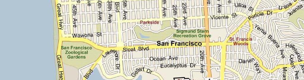
3 PROJECT DESCRIPTION Project Location The existing 134-acre San Francisco State University (SFSU) campus is located in the southwestern corner of the City and County of San Francisco, in California. (See Figure 1, Regional Location) The Campus Master Plan project boundary encompasses an additional 10 acres of land, including: (1) the three blocks of University Park South and the Tapia Triangle, owned by the San Francisco State University Foundation, and (2) the School of the Arts (SOTA) site, currently under negotiation for purchase by the University. The 144-acre planning area is generally bounded by Lake Merced Boulevard and the lake and its associated open spaces, including Harding Park, public and private golf courses, Fort Funston, and the San Francisco Zoo on the west; 19 th Avenue (State Route 1) and residential development in the Ingleside neighborhood on the east; the Stonestown shopping center, Lowell High School, and Lakeshore Alternative Elementary School to the north; and Parkmerced and other residential development to the south. The Pacific Ocean lies to the west of the campus, beyond Lake Merced. Existing Campus Setting The campus is located in an urban area of San Francisco and has been mostly built out with improvements and intense urban uses. The campus is composed of more than 50 buildings that were built between 1939 and the present. The buildings provide for academic, library, student services, administrative, support services, parking, and residential uses. The existing buildings range in size from less than 1,000 gross square feet (gsf) to over 600,000 gsf. In total, there is approximately 3.6 million gsf of space in these buildings, not including the recently acquired University Park North and University Park South complexes. (See Figure 2, Existing Campus Facilities) In general, current campus land uses are grouped geographically. Academic buildings and the library surround the Quad. Groups of residential buildings lie to the north, west, and south of the academic core. Other uses are spread throughout the campus. The campus has five large open spaces the Quad and four playing fields. There is limited curbside parking along the perimeter of the campus, and a few on-campus surface parking lots. The bulk of the University s parking needs is met through the multi-story parking garage east of Maloney Field. The campus has considerable topographic change. The most prominent feature is the valley running eastwest between 19th Avenue and Lake Merced Boulevard, just north of the academic core. The valley is the remnant of a steep, V-shaped canyon cut by a seasonal stream that flowed into Lake Merced. The canyon was filled in the early 1940s to form three terraces descending westward. The upper level, just west of 19 th Avenue, was initially intended as a playfield and currently contains construction trailers. Cox Stadium occupies the middle level. The lowest level was originally maintained as a lawn and served as an additional playfield, but is now occupied by the parking garage, the Central Plant, and Maloney Field. The campus landscape includes a variety of open spaces, from open lawn areas and playfields to dense forest and sheltered courtyards. Open spaces are defined by building forms and tree masses. The campus landscaping is dominated by mature stands of Monterey Cypress, Monterey Pine, and Eucalyptus. Several of these small groves located in and around the Quad formerly stood amid agricultural fields and San Francisco State University 2 Campus Master Plan
4 constitute the only surviving pre-campus vegetation. These original Monterey Cypress and Monterey Pine groves have dictated the location and footprint of many of the campus buildings in the core. Along Holloway Avenue, London Plane trees and Canary Island Pine also exist. There are no surface water bodies, sensitive habitat, or wetlands on the campus. Preliminary Project Description Introduction SFSU is currently updating the SFSU Campus Master Plan, creating a comprehensive document that addresses all aspects of future physical development and land use on the campus to accommodate the proposed increased enrollment ceiling to 25,000 FTE. 1 The proposed Campus Master Plan will guide change to the campus over the long term and will ultimately give physical form to the University s strategic vision and values. The purpose of the proposed Campus Master Plan is to address the recent acquisition of property, aging facilities, changing student demographics, and the need for additional academic building space and other support space to accommodate the growth in enrollment anticipated to occur through the planning horizon (2020). The CSU system requires each campus to maintain a master plan guiding its development. The CSU system further requires that the campuses undertake periodic review and revision of their master plans, in part to ensure that proposed capital improvement programs remain in compliance with those plans. The CSU system is designed to accept the top academic one-third of graduating high school students, and each campus within the system is required to accommodate its share of present and anticipated future students. The CSU system is facing increased projected demand for higher education over the next 10 years and beyond. Consequently, the new Campus Master Plan for SFSU is intended to accommodate the proposed increased enrollment ceiling to 25,000 FTE, a 25 percent increase in enrollment capacity. The previous SFSU Campus Master Plan that comprehensively addressed campus growth and development was completed in 1989, almost 20 years ago, and has been updated numerous times since then to accommodate physical changes to the campus. More recently, the University has acquired significant new properties and is preparing this updated Campus Master Plan in part to integrate the new properties into the campus. SFSU will use the proposed Campus Master Plan as a means to evaluate existing conditions, assess the influence of enrollment growth, recommend capacity limits for new development, and establish guidelines and recommendations for future building projects. The proposed Campus Master Plan addresses only the SFSU main campus and does not include the University s satellite centers, such as the Downtown Center on Market Street and the Romberg Tiburon Center in Marin County. The population increase, building concept, and other improvements included in the proposed Campus Master Plan are described below. 1 SFSU uses the student full time equivalent (FTE) for enrollment planning and for physical planning purposes. One FTE is defined as one student taking 15 course units, which represents a full course load. Students taking fewer course units are considered to constitute a fraction of an FTE (10 course units =.66 FTE), whereas students taking more than 15 course units constitute more than one FTE (20 units = 1.33 FTEs). While this is the case, student headcount (HC) will be used as the basis for analysis in the EIR, as it accounts for the total number of students enrolled on campus. However, total student headcount may be adjusted for some environmental topics (e.g., traffic) to account for the number of SFSU-related population that could be on campus at any given time. San Francisco State University 3 Campus Master Plan
5 Population Increase Currently, the SFSU campus has an enrollment cap of 20,000 FTE. The primary purpose of the proposed Campus Master Plan is to address an enrollment ceiling increase to 25,000 FTE, which would represent a headcount of about 36,000 students. Additionally, SFSU is projecting that faculty and staff would increase from about 3,600 employees at the present time to about 4,100 employees at an enrollment level of 25,000 FTE students. The proposed Campus Master Plan would guide the construction of new building space to serve this increased population. The California State University Board of Trustees will consider the approval of the proposed Campus Master Plan and the proposed enrollment ceiling increase to 25,000 FTE for the SFSU campus. Consequently, the EIR on the proposed Campus Master Plan will evaluate the potential campus enrollment growth to 25,000 FTE through the planning horizon (2020) and the building program and other improvements required to serve this population. Building Concept Changes being contemplated under the proposed Campus Master Plan involve the demolition of a number of existing buildings that are beyond their useful life. The proposed Campus Master Plan would also facilitate the construction of new modern, efficient and larger buildings to serve the planned increased population. Campus land would be used more effectively and efficiently through more purposeful siting of new buildings to create internal courtyards and better connections between open spaces, thus generally maintaining or increasing the overall amount of open space on the campus through Overall, the proposed Campus Master Plan would result in a net increase in academic and academic support building space of 900,000 gsf. Additional building space would also be provided within new on-campus housing and a new hotel and conference center, as further described below. The proposed Campus Master Plan would designate sites for the new academic, semi-public, residential, recreation, maintenance, and parking buildings and facilities as further described below. (See Figure 3, Master Plan Buildout) Planning and design principles and guidelines identified in the proposed Campus Master Plan will guide the development of these sites. Academic The proposed Campus Master Plan calls for the construction of new and replacement academic buildings in and around the academic core of the SFSU campus. New or replacement buildings would be constructed for the following academic programs: Clinical Sciences, Behavioral and Social Sciences, Health and Human Services, Science, Business, and Ethnic Studies & Psychology. Additional academic buildings would also likely be provided to allow for growth in academic programs through the planning horizon. The proposed Campus Master Plan also calls for the expansion of the existing library building as part of the overall growth in academic space on campus. Semi-Public Services The proposed Campus Master Plan calls for the construction of new semi-public buildings at prominent campus corners. These buildings would include uses that have both academic and public use space and San Francisco State University 4 Campus Master Plan
6 include: (1) a new Creative Arts facility, located near the intersection of Lake Merced Boulevard and Font Boulevard, that would have both academic space and theater space; (2) a new Gym/Recreation- Wellness Center, located at the intersection of Lake Merced Boulevard and Winston Drive (see further description below under Recreation Center and Fields); and (3) a new hotel and conference center, located at the intersection of 19 th Avenue and Buckingham Way. The new 250-room hotel and 110,000 gsf conference center will serve SFSU as well as the larger community. The conference center will provide educational space for University-sponsored conferences and events, as well as space for non-university events. It will also house a visitor center for prospective students and families and other University guests. Hotel accommodations would support the various events at the conference center and provide accommodations for other University guests. Residential The campus provides housing in a number of on-campus buildings, including Mary Ward Hall, Mary Park Hall, Towers and Village at Centennial Square, and Science and Technology Theme Community. Additionally, the University has acquired numerous apartment buildings along Buckingham Way and Holloway Avenue. These include the former Stonestown apartments, now called University Park North (UPN), and several buildings formerly part of Villa Parkmerced, now called University Park South (UPS). Given that UPN and UPS were recently acquired by SFSU, they are currently occupied by only about 30 percent SFSU affiliates with the remainder being occupied by the general public. The proposed Campus Master Plan seeks to maximize the provision of housing on campus in order to minimize the potential environmental effects of growth and development under the proposed Campus Master Plan related to vehicles traveling to the campus (e.g., traffic congestion, air emissions, trafficrelated noise, etc.). Through the planning horizon of the proposed Campus Master Plan, some of the housing at UPN and UPS would ultimately be replaced in phases with new higher density housing for use by SFSU affiliates. The proposed Campus Master Plan would also construct new housing on the existing Sutro Library site. New construction under the proposed Campus Master Plan would provide for a net increase of about 700 beds for students and about 410 units for faculty, staff, graduate and upper-division students, and students with families. Additionally, the remainder of UPN and UPS housing will gradually become converted for University uses as current occupants vacate their units. Therefore, additional beds and/or units would also be provided on campus through the conversion of this existing housing for use by SFSU affiliates. Overall, the number of students, faculty and staff that would be housed on campus is expected to increase under the proposed Campus Master Plan. San Francisco State University 5 Campus Master Plan
7 Recreation Center and Fields The proposed Campus Master Plan would provide for the replacement of the existing Gymnasium with a new larger Gymnasium/Recreation-Wellness Center to be located at the intersection of Lake Merced Boulevard and Winston Drive, at the site of the existing Lakeview Center and Corporation Yard, just north of North State Drive. As the new Creative Arts facility would remove an existing softball field, the proposed Campus Master Plan also calls for the replacement of a field that previously existed off of 19 th Avenue, just north of Thorton and Hensill Halls. Maintenance Facilities The proposed Campus Master Plan anticipates new and replacement maintenance facilities that would likely be required to serve campus growth and development through The Corporation Yard facilities would be relocated to Parking Lot 25, just north of the Sutro Library to allow for the construction of the Gym/Recreation-Wellness Center, as indicated previously. Additionally, a new satellite power plant would also be located on the northern edge of the campus to provide adequate power generation and heating hot water capacity on campus. Parking The proposed Campus Master Plan calls for the closure of a portion of the existing parking structure located in the valley portion of the campus. A number of smaller decentralized parking garages associated with semi-public buildings, as well as on street and surface parking would be provided on campus to replace this parking. Overall, the proposed Campus Master Plan calls for only minor increases in overall parking capacity on campus through 2020 in order to maximize the use of alternative modes of travel to the campus (e.g., transit, bicycles, walking). Other Improvements and Programs The proposed Campus Master Plan also provides for a variety of other landscaping, circulation, and utility improvements and programs appropriate to serve the new population and building space. San Francisco State University 6 Campus Master Plan
8 Environmental Analysis Introduction A Draft EIR will be prepared by SFSU to address the potential significant environmental effects associated with the adoption and subsequent implementation of the proposed Campus Master Plan and enrollment ceiling increase to 25,000 FTE. The proposed Campus Master Plan will be evaluated at a program level in this EIR. A program EIR is appropriate for a series of actions that can be characterized as one large project and are related as logical parts in a chain of contemplated actions. A project EIR typically focuses on the environmental changes associated with all phases of a specific development project, including planning, construction, and operation. A program EIR allows the lead agency to consider broad policy alternatives and program-wide mitigation measures early in the program process; subsequent project-specific activities are evaluated in light of the program EIR to determine if additional environmental documentation is required. A program-level analysis is intended to provide the public and decision-makers with an overview of the potential environmental impacts associated with one large project. SFSU does not anticipate proceeding with development of all proposed Campus Master Plan projects in the immediate future, nor has it developed sufficient project detail to enable analysis of all projectspecific impacts at this time. Because of the long-term nature of the Campus Master Plan, the precise nature, size, and location of all the proposed programs and facilities cannot be accurately projected at this time. As warranted under CEQA, additional environmental review of Campus Master Plan projects will be undertaken as the plan is implemented. Project implementation would require approval from several entities. The Trustees of California State University are responsible for approval and adoption of the proposed Campus Master Plan, approval of an enrollment ceiling increase to 25,000 FTE, and certification of the EIR. State Fire Marshall review for fire and life safety will be required during subsequent project-specific approvals for individual building projects that could be implemented under the Master Plan. Potential Environmental Effects Of The Project Based on preliminary review of the proposed Campus Master Plan, consistent with Section of the California Environmental Quality Act (CEQA) Guidelines, the CSU has determined that an EIR should be prepared to analyze the potential environmental effects of the proposed project. Based on this preliminary review, the CSU proposes research, analysis, and study of the following environmental topics in this EIR (see below for the preliminary scope of analyses for these topics): Aesthetics Air Quality Biological Resources Cultural Resources Geology, Soils, and Seismicity Hazards and Hazardous Materials Hydrology and Water Quality Land Use and Planning Noise Population and Housing Traffic, Circulation, and Parking Utilities San Francisco State University 7 Campus Master Plan
9 The CSU has also determined that there is not a likelihood of potentially significant effects related to the following environmental topics. The Trustees propose that the EIR indicate the reasons why these effects were determined not to be significant and are therefore not addressed in detail in the EIR: Agricultural Resources Mineral Resources Public Services Preliminary Scope of Analysis The preliminary scope of analysis is provided below for the topics to be addressed in detail in the EIR. The Trustees of the CSU will consider the comments received in response to this Notice of Preparation in determining the final scope and content of the EIR for this project. Any comments provided should identify specific topics of environmental concern and the reason for suggesting their evaluation in the EIR. The EIR will address project and cumulative impacts as appropriate for the particular topic. Aesthetics This section of the EIR will address the general effects of proposed development at SFSU through 2020, including the potential loss of existing scenic resources, and effects on any scenic views and vistas, the visual character and quality of the campus and surroundings, and the effects of light and glare. The environmental setting will be developed based on review of existing information regarding landscape and setting, open space, view corridors, views, entrances and edges, etc. Master Plan renderings and site plans will be used as the basis for understanding and analyzing the appearance and scale of the proposed facilities. No visual simulations are considered necessary given that the proposed Campus Master Plan constitutes a program to guide future development and does not provide specific design and building information that could be used as the basis for conducting such simulations. Relative to any major new sources of light, the additional light and glow that the facilities would create and its potential to affect residential areas off campus will be evaluated. Air Quality The air quality impact analysis will describe existing conditions and potential air quality impacts from the implementation of the proposed Campus Master Plan. Bay Area Air Quality Management District (BAAQMD) CEQA Guidelines will be followed to analyze air quality impacts. This will entail characterizing regional meteorology, summarizing air quality data for the project area from the California Air Resources Board database, and presenting the current status of the air basin relative to the federal and state air quality standards. Regional emissions of criteria pollutants from additional vehicle trips associated with campus growth under the proposed Campus Master Plan will also be estimated using a model that is approved by the BAAQMD. Emissions from future stationary sources and building space will also be estimated. The total regional emissions (from vehicular, stationary, and area sources) from operations will be compared to significance thresholds for projects established by the BAAQMD. Additionally, localized emissions of carbon monoxide (CO) at congested intersections will also be evaluated and modeled if necessary. San Francisco State University 8 Campus Master Plan
10 Because the proposed project is a master plan and not a construction project, construction emissions will not be estimated. This approach is also supported by BAAQMD s approach to examining construction impacts, which emphasizes the implementation of effective and comprehensive control measures rather than detailed quantification of emissions. Mitigation measures to reduce construction emissions will be discussed. Biological Resources This section of the EIR will evaluate the potential for development under the proposed Campus Master Plan to affect biological resources, including sensitive natural communities, special-status species, and wildlife movement corridors. Any conflicts of the project with applicable policies and plans for protecting biological resources will also be identified and evaluated. A site reconnaissance of the campus and a search of the CNDDB to gather data will be conducted to characterize existing conditions. Direct and indirect impacts on any identified biological resources on campus or in the adjacent Lake Merced area will be evaluated. Appropriate mitigation measures will be developed for any identified significant impacts. Cultural Resources This section of the EIR will evaluate the potential for development under the proposed Campus Master Plan to affect cultural resources. The potential for future projects to affect known resources and the potential for any such impacts to be significant under CEQA guidelines will be determined. The EIR will include programmatic mitigation measures including surveys and testing for cultural resources each time a new project is proposed. Mitigation measures to address the inadvertent discovery of deposits during construction will also be included. As some of the buildings are currently over 50 years old, or will be over that age within the planning horizon of the proposed Campus Master Plan, an inventory these buildings will be conducted as part of the EIR as they may constitute historic resources under CEQA. EIR mitigation measures will require that if and when a project is proposed that would remove one of these buildings, an evaluation of the structure will be conducted and that recordation and other measures would be implemented if warranted to reduce the magnitude of the impact. Geology, Soils, and Seismicity The impact analysis under this resource area will focus on the potential for the project to expose people or structures to effects from fault rupture, seismic ground shaking, ground failure, lateral spreading, liquefaction or other similar conditions. The potential for these impacts in the light of the campus geology and soil conditions will be determined. Additionally, the regulations that are in place (such as the Uniform Building Code) to minimize the potential for significant impacts will be identified. Hazards and Hazardous Materials The main concern relative to hazards and hazardous materials for the campus will relate to the presence of contaminated building materials in some of the older buildings on the campus that may be demolished. Based on the existing conditions evaluation completed as part of the planning effort, buildings that would be of concern, and mitigation measures for remediation and handling of contaminated building materials San Francisco State University 9 Campus Master Plan
11 will be identified. The EIR will also briefly describe the use of hazardous chemicals on the campus for research, building maintenance, and landscape maintenance. Hydrology and Water Quality The main issues relative to hydrology and water quality will relate to indirect impacts to water quality that could occur in the adjacent Lake Merced, as the proposed Campus Master Plan will likely contemplate an open system of rain gardens, bio-swales, open channels, and detention/filtration zones that will ultimately drain/infiltrate to Lake Merced to the west of the campus. Given this, the proposed Campus Master Plan would not be expected to result in increased discharge of campus storm water to the City s combined sewer system and therefore would not result in increased loading on the City s wastewater treatment plant (WWTP) during wet weather conditions. While this is the case, the EIR will analyze the effect of campus growth on wastewater discharges to the City s combined sewer system and WWTP. Program-level mitigation measures will be developed for any identified significant impacts and are expected to focus on measures to ensure that water quality in Lake Merced would be protected. Land Use and Planning The main CEQA questions with respect to this resource area are whether the proposed project would: (1) conflict with an applicable land use plan, policy or regulation of an agency with jurisdiction over the project, (2) result in development that is incompatible with adjacent land uses, and/or (3) divide an existing community. As a state project, there would be no municipal jurisdiction over the project; therefore, SFSU is not subject to municipal land use enactments, such as the San Francisco General Plan. Nevertheless, such local planning polices are of interest to the SFSU campus because campus development and local development are coincident. Moreover, the California State University System has a tradition of working cooperatively with the local communities, and it is the goal of the campus to seek consistency with local plans and policies, where possible. Therefore, a summary of relevant City and County of San Francisco land use plans and policies will be presented in this EIR. Significant environmental impacts, if any, will be identified related to conformance with these plans and policies. The proposed development under the new Campus Master Plan will also be examined to determine whether it would be compatible with existing land uses on and adjacent to the campus. Noise A noise technical analysis will be conducted that will present noise impacts from campus growth under the new Campus Master Plan. The existing noise environment in the project area will be characterized by identifying existing sources of noise, measuring ambient noise levels, and identifying existing noisesensitive receptors. Long-term and short-term baseline noise measurements will be conducted on and adjacent to the campus in order to characterize ambient noise levels. These measurements are typically made near streets and intersections that are likely to experience the greatest project-related traffic increases. Noise measurements are likely to be conducted at locations along 19 th Avenue, Font Boulevard, Holloway Avenue, Buckingham Way, Winston Drive, Vidal Drive, and Junipero Serra Boulevard. San Francisco State University 10 Campus Master Plan
12 The analysis of project impacts will focus on traffic-related noise increases as a consequence of increased traffic to the campus. The FHWA Traffic Noise Model will be used to estimate noise from vehicular traffic. Noise levels will be modeled at representative sensitive receptors as well as at a standard distance from the roadway to estimate noise levels under project and cumulative conditions. Noise from stationary sources and construction sites will be discussed qualitatively and will not be modeled. Mitigation measures will be recommended for noise impacts, if warranted. Population and Housing The issue of concern related to this topic is whether the project would result in an increase in employment or population and thereby create a demand for housing that cannot be met with existing and planned housing resources. This analysis will be completed by estimating the total population and the number of households associated with the Campus Master Plan and comparing the needed number of housing units with the number of existing and projected units on campus, in San Francisco, and in other Bay Area communities. The proposed Campus Master Plan seeks to maximize the provision of housing on campus in order to minimize the potential effects of growth and development under the proposed Campus Master Plan (e.g., demand for off-campus housing, traffic congestion, air emissions, traffic-related noise, etc.). However, there will be a net increase in demand for housing off-campus even with the provision of new on-campus housing under the proposed Campus Master Plan. This net increase in demand will be compared to existing and projected units in San Francisco and other Bay Area communities, based on demographic information from the U.S. Census Bureau, the Association of Bay Area Governments, the City and County of San Francisco, and the California Department of Finance. Traffic, Circulation, and Parking The transportation analysis for the Campus Master Plan EIR will need to fully disclose the existing and anticipated future conditions including traffic operations, circulation, parking, and alternative modes of travel. The analysis will identify the impacts of the full buildout of the campus under this Campus Master Plan on the roadway network through Level of service impacts will be evaluated for the following 19 study intersections during the a.m. and p.m. peak hours: Junipero Serra Boulevard/19th Avenue Junipero Serra Boulevard/Holloway Avenue Junipero Serra Boulevard/Winston Drive Junipero Serra Boulevard/Ocean Avenue Junipero Serra Boulevard/Sloat Boulevard/Portola Drive 19th Avenue/Sloat Boulevard 19th Avenue/Ocean Avenue 19th Avenue/Eucalyptus Drive 19th Avenue/Winston Drive 19th Avenue/Holloway Avenue Lake Merced Boulevard/John Daly Boulevard Lake Merced Boulevard/Brotherhood Way Lake Merced Boulevard/Font Boulevard Lake Merced Boulevard/South State Drive Lake Merced Boulevard/North State Drive San Francisco State University 11 Campus Master Plan
13 Lake Merced Boulevard/Winston Drive Lake Merced Boulevard/Middlefield Drive Sloat Boulevard/34th Avenue Skyline Boulevard/John Daly Boulevard Traffic impacts will also be evaluated for the following three roadway segments: 19 th Avenue, between Junipero Serra Boulevard and Holloway Avenue 19 th Avenue, between Holloway Avenue and Winston Drive 19 th Avenue, between Winston Drive and Sloat Boulevard The existing conditions analysis will be based on the following: (1) peak hour turning movement counts at the 19 study intersections collected for the a.m. and p.m. peak hour on weekdays, (2) 24-hour bidirectional volumes collected along the study roadway segments, (3) lane geometrics, and (4) signal timing information. The traffic impact analysis will be conducted using Highway Capacity Manual methodologies as identified in the Traffic Impact Analysis Guidelines (TIAG) for the City and County of San Francisco. To estimate future conditions on the roadway network, a background growth rate of one percent per year will be applied to the traffic volumes, which is one of the three acceptable approaches identified in the TIAG for the analysis of future conditions. The traffic impact analysis will identify project and cumulative impacts related to intersection congestion and will identify appropriate mitigation measures, such as capacity improvements or operational improvements. The impact analysis will also consider issues related to parking, bicycle and pedestrian circulation, transit, and hazards. Utilities This analysis will address water, storm water, wastewater, solid waste, natural gas, and electrical service, and will focus on whether the Campus Master Plan will lead to the expansion of existing utilities or the construction of new facilities that could result in significant environmental impacts. Potential project increases in demand will be identified for all utilities noted above, and compared to available infrastructure. Mitigation measures will be presented for any identified significant impacts. Alternatives Analysis As required by CEQA, the EIR will include a reasonable range of alternatives to the proposed project or its location that could feasibly attain most of the objectives of the project. The focus of the analysis will be on alternatives that avoid or reduce significant impacts. The types of alternatives that will likely be considered in the EIR include: (1) a reduced program alternative that would consider a smaller building program and/or campus population, (2) an alternative design concept that would consider alternative locations and/or arrangements of proposed buildings, (3) an increased program alternative that would consider a larger building program for a given type of use (e.g., housing) or range of uses, and (4) a no project alternative that would consider no further growth or development at the SFSU campus. San Francisco State University 12 Campus Master Plan


14

15

16
4.8 Land Use and Planning Environmental Setting Impacts and Mitigation Measures References...4.
 TABLE OF CONTENTS 4.8 Land Use and Planning...4.8-1 4.8.1 Environmental Setting...4.8-1 4.8.2 Impacts and Mitigation Measures...4.8-5 4.8.3 References...4.8-11 FIGURES Figure 4.8-1 Figure 4.8-2 Figure
Project Description...3-1
 TABLE OF CONTENTS Chapter 3 Project Description...3-1 3.1 Introduction...3-1 3.2 Project Location and Vicinity...3-2 3.3 Existing Site Conditions...3-2 3.3.1 Built Environment...3-2 3.3.2 Environmental
4.8 LAND USE AND PLANNING
 4.8 LAND USE AND PLANNING 4.8.1 INTRODUCTION This section describes existing and planned land uses at the Hayward campus and analyzes the impact of implementation of the proposed Master Plan on land uses
4.1 AESTHETICS Environmental Setting
 4.1 AESTHETICS This section of the Focused Tiered Final EIR presents potential aesthetic impacts of the Creative Arts and Holloway Mixed-Use Project (Project). Preparation of this Focused Tiered Final
3.10 LAND USE SETTING PROJECT SITE EXISTING LAND USE DESIGNATIONS AND ZONING. General Plan Land Use Designations.
 This section of the Draft EIR addresses the existing land uses on and adjacent to the project site and discusses the potential impacts of the proposed project on existing land uses. Key issues addressed
COMMUNITY DEVELOPMENT SERVICES PLANNING AND BUILDING DEPARTMENT PLACERVILLE OFFICE:
 COMMUNITY DEVELOPMENT SERVICES PLANNING AND BUILDING DEPARTMENT http://www.edcgov.us/devservices/ PLACERVILLE OFFICE: LAKE TAHOE OFFICE: 2850 Fair Lane Court, Placerville, CA 95667 924 B Emerald Bay Rd.
TABLE OF CONTENTS. Tables Table UC Davis Park and Open Space Resources
 TABLE OF CONTENTS 4.13 Recreation... 4.13-1 4.13.1 Environmental Setting... 4.13-1 4.13.2 Impacts and Mitigation Measures... 4.13-4 4.13.3 References... 4.13-8 Tables Table 4.13-1 UC Davis Park and Open
SAN RAFAEL GENERAL PLAN 2040 INTRODUCTION AND OVERVIEW
 SAN RAFAEL GENERAL PLAN 2040 INTRODUCTION AND OVERVIEW Steering Committee Presentation February 14, 2018 Purpose of General Plan Guide land use and development decisions Coordinate transportation, infrastructure,
Chapter 22. Alternatives to the Proposed Project
 Page 22-1 Chapter 22. Alternatives to the Proposed Project Introduction This chapter assesses the potential environmental effects of alternatives to the Proposed Project. The alternatives analyzed include
EXECUTIVE SUMMARY. Introduction
 EXECUTIVE SUMMARY Introduction State Route 68 is a designated scenic route that connects the world-renowned Monterey Peninsula to US Highway 101 and the Salinas Valley. SR 68 is a key route for bicycle,
San Francisco State University Campus Master Plan. Chapter 7. Urban Design Plan
 San Francisco State University Campus Master Plan Chapter 7. 7. Defining Elements The urban design plan for the campus, described in the accompanying Master Plan Buildout diagram, expands upon the framework
CHAPTER 3 PROJECT DESCRIPTION
 CHAPTER 3 PROJECT DESCRIPTION 3.1 PROJECT OVERVIEW San Francisco State University (SF State) proposes to develop the Creative Arts and Holloway Mixed-Use Project (Project) in the southern portion of the
Gold Line Bus Rapid Transit Transit Oriented Development (BRTOD) Helmo Station Area Plan
 Helmo Station Area Plan") Appendix F Gold Line Bus Rapid Transit Transit Oriented Development (BRTOD) Helmo Station Area Plan Introduction and Purpose of the Plan The Gold Line Bus Rapid Transit facility is an eleven-mile dedicated
Appendix F Gold Line Bus Rapid Transit Transit Oriented Development (BRTOD) Helmo Station Area Plan Introduction and Purpose of the Plan The Gold Line Bus Rapid Transit facility is an eleven-mile dedicated
4. ENVIRONMENTAL IMPACT ANALYSIS 7. LAND USE AND PLANNING
 4. ENVIRONMENTAL IMPACT ANALYSIS 7. LAND USE AND PLANNING 4.7.1 INTRODUCTION The following analysis discusses the consistency of the Proposed Project with the corresponding land use and zoning designations
SPECIFIC PLAN Requirements
 CITY OF LANCASTER PLANNING DEPARTMENT 44933 Fern Avenue, Lancaster, California 93534 (661) 723-6100 SPECIFIC PLAN Requirements Purpose The purpose of a specific plan is to provide for the logical development
I. STAFF POLICY RECOMMENDATIONS. The following RMP policy strategies are proposed by staff in support of a Scenic Resource Protection Program:
 Policy Consideration: Scenic Resource Protection Program Status: For Consideration by the Highlands Council at September 14, 2006 Work session Date: September 12, 2006 I. STAFF POLICY RECOMMENDATIONS The
PROJECT SUMMARY. University of California, Irvine Humanities Building. Project No FINAL INITIAL STUDY/MITIGATED NEGATIVE DECLARATION
 PROJECT SUMMARY University of California, Irvine Humanities Building Project No. 991077 FINAL INITIAL STUDY/MITIGATED NEGATIVE DECLARATION State Clearinghouse No. 2007011035 March 2007 Humanities Building
2019 Hillcrest Campus LRDP EIR Scoping Meeting
 2019 Hillcrest Campus LRDP EIR Scoping Meeting March 21, 2018 Agenda Scoping Meeting Purpose Hillcrest Campus Context What Is The Long Range Development Plan (LRDP)? Why A New Plan? Key LRDP Components
Chapter 6: Community Character
 Chapter 6: Community Character The term "community character" covers a broad spectrum of concerns. First and foremost, community character is a visual concept. In Long Grove, however, community character
DRAFT ENVIRONMENTAL IMPACT REPORT NORTH HOLLYWOOD-VALLEY VILLAGE COMMUNITY PLAN AREA
 Environmental Review City Hall 200 N. Spring Street, Room 750 Los Angeles, CA 90012 DRAFT ENVIRONMENTAL IMPACT REPORT NORTH HOLLYWOOD-VALLEY VILLAGE COMMUNITY PLAN AREA The Plaza at The Glen Mixed Use
No comments related to land use and planning issues were received in response to the Notice of Preparation.
 4.8 LAND USE AND PLANNING This section analyzes the impacts relative to land use and planning that would occur as a result of implementation of the proposed Facilities Master Plan (proposed project). This
3.0 PROJECT DESCRIPTION
 3.0 PROJECT DESCRIPTION 3.1 BACKGROUND Under California law (Government Code Section 65300 et seq.), every city and county is required to have a general plan. The general plan is to be comprehensive and
SECTION 2.0 INTRODUCTION
 SECTION 2.0 INTRODUCTION 2.1 PURPOSE AND SCOPE OF THE EIR Environmental Impact Reports (EIR) are informational documents which wil inform public agency decision-makers and the public generally of the significant
Goal 1: To Encourage the Orderly, Harmonious and Judicious Use of University Resources in the Development of University Land.
 2.0 Future Land Use Goal 1: To Encourage the Orderly, Harmonious and Judicious Use of University Resources in the Development of University Land. Objective 1.1: Make available future building sites that
Transportation Improvements
 Transportation Improvements 0 0 Volume II of the Final EIS for the DHS Headquarters consolidation at St. Elizabeths includes analysis to transportation improvements for the DHS Headquarters Consolidation
NOTICE OF PREPARATION
 Date: June 30, 2017 CITY OF CITRUS HEIGHTS COMMUNITY & ECONOMIC DEVELOPMENT DEPARTMENT, PLANNING DIVISION 6360 Fountain Square Drive, Citrus Heights, CA 95621 (916) 727-4740 NOTICE OF PREPARATION To: Subject:
Department of Community Development. Planning and Environmental Review Division Revised Notice of Preparation
 Department of Community Development Michael J. Penrose, Acting Director Divisions Building Permits & Inspection Code Enforcement County Engineering Economic Development & Marketing Planning & Environmental
ENVIRONMENTAL INITIAL STUDY BERKELEY CITYWIDE POOLS MASTER PLAN
 ENVIRONMENTAL INITIAL STUDY FOR THE BERKELEY CITYWIDE POOLS MASTER PLAN CITY OF BERKELEY PARKS RECREATION AND WATERFRONT DEPARTMENT SEPTEMBER 1, 2009 ENVIRONMENTAL INITIAL STUDY BERKELEY CITYWIDE POOLS
4-Town Comprehensive Plan DRAFT 7/30/07
 4-Town Comprehensive Plan DRAFT 7/30/07 Acknowledgements ning Committee Town of Harrisburg Norman Roof Randy Nicol Town of Martinsburg Terry Thisse Paul Kelly Town of Montague Jan Bagdanowicz Wendy Perry
ESTABLISH AN EFFICIENT TOWN CENTER
 ESTABLISH AN EFFICIENT TOWN CENTER 4 Overview Lisbon residents are proud of the history of Newent and at the same time recognize its current importance as a centralized location for a variety of municipal
III. PROJECT DESCRIPTION
 III. PROJECT DESCRIPTION LOCATION AND BOUNDARIES The City of Manhattan Beach is located in the South Bay region of Los Angeles County, California, approximately 2 miles south of the Los Angeles International
REPORT TO PLANNING COMMISSION
 CITY OF Meeting Date: October 25, 2011 Agenda Item: Community Development Department Planning Division P. O. Box 151560, San Rafael, CA 94915-1560 PHONE: (415) 485-3085/FAX: (415) 485-3184 Case Numbers:
November 9, Lew Jones, Director of Facilities Berkeley Unified School District 1720 Oregon Street Berkeley, CA 94703
 Planning and Development Department Land Use Planning Division November 9, 2006 Lew Jones, Director of Facilities Berkeley Unified School District 1720 Oregon Street Berkeley, CA 94703 SUBJECT: Comments
NOTICE OF PREPARATION OF AN ENVIRONMENTAL IMPACT REPORT AND SCOPING MEETING FOR THE LAND PARK COMMERCIAL CENTER PROJECT
 NOTICE OF PREPARATION OF AN ENVIRONMENTAL IMPACT REPORT AND SCOPING MEETING FOR THE LAND PARK COMMERCIAL CENTER PROJECT PUBLIC COMMENT PERIOD November 12, 2015 to December 14, 2015 INTRODUCTION The City
PROJECT BACKGROUND. Preliminary Design Scope and Tasks
 PROJECT BACKGROUND Preliminary Design Scope and Tasks The purpose of this Study is the development of preliminary designs for intersection improvements for Trunk Highway (TH) 36 at the intersections of
8 October 14, 2015 Public Hearing
 8 October 14, 2015 Public Hearing APPLICANT & PROPERTY OWNER: PRICE S HOLDINGS, LLC STAFF PLANNER: Karen Lasley REQUEST: A. Conditional Use Permit (Automobile Repair Garage) B. Change in Nonconforming
This is the East Carolina University Comprehensive Facilities Master Plan Final Draft Plan Review. This workbook reviews the campus draft master plan
 This is the East Carolina University Comprehensive Facilities Master Plan Final Draft Plan Review. This workbook reviews the campus draft master plan first presented on campus on June 29 and June 30, 2011.
APPENDIX F. Mitigation Monitoring and Reporting Program
 APPENDIX F Mitigation Monitoring and Reporting Program APPENDIX F MITIGATION MONITORING AND REPORTING PROGRAM This Mitigation Monitoring and Reporting Program (MMRP) for the Creative Arts and Holloway
3. VISION AND GOALS. Vision Statement. Goals, Objectives and Policies
 Vision Statement Queen Creek s interconnected network of parks, trails, open spaces and recreation opportunities provide safe and diverse activities and programs that sustain its unique, small town, equestrian
Appendix E: Illustrative Green Infrastructure Examples
 Appendix E: Illustrative Green Infrastructure Examples Integrating LID into San Francisco s Urban Landscape Figure E. High-density Residential Figure E. Low-density Residential Figure E. Mixed Use 7 Figure
~P'~'~; SAN FRANCISCO
 ~o counr~, ~P'~'~; SAN FRANCISCO ~'.~ PLANNING DEPARTMENT a 2 757 O~~~S 0 Case No.: Project Address: Zoning: Certificate of Determination COMMUNITY PLAN EVALUATION UMU (Urban Mixed Use) District 58-X Height
NOTICE OF PREPARATION OF ENVIRONMENTAL IMPACT REPORT
 NOTICE OF PREPARATION OF ENVIRONMENTAL IMPACT REPORT TO: State Clearinghouse, Responsible and Trustee Agencies, and Other Interested Parties DATE: May 18, 2017 SUBJECT: Notice of Preparation of Environmental
Visual and Aesthetics
 Such a connection could accommodate timed transfers and improve connections between local transit service and Presidio Shuttle service. Level of Service The results of the analysis are provided on a route-by-route
Notice of Preparation of an Environmental Impact Report and Scoping Meeting for the Canyon Lane Roadway Improvements Development Project
 of an Environmental Impact Report and Scoping Meeting for the As the Lead Agency, the County of San Mateo (County) will prepare an Environmental Impact Report (EIR) for the (project), and would like your
LOS ANGELES CITY PLANNING DEPARTMENT STAFF REPORT
 LOS ANGELES CITY PLANNING DEPARTMENT STAFF REPORT LOS ANGELES CITY PLANNING COMMISSION CASE NO: CPC 2006-9374 CRA CEQA: Exempt DATE: December 21, 2006 Location: Valley Plaza and Laurel Plaza TIME: after
Introduction and Overview
 Introduction and Overview Articulate local values and priorities Guide land use and development decisions Coordinate transportation, infrastructure, and City services with expected growth and available
Errata 1 Landmark Apartments Project Final Environmental Impact Report
 Errata 1 Project Final Environmental Impact Report This document addresses proposed refinements to the Project evaluated in the (EIR or Final EIR) prepared in September 2016. Specifically, in response
Chapter 1 - General Design Guidelines CHAPTER 1 GENERAL DESIGN GUIDELINES
 CHAPTER 1 GENERAL DESIGN GUIDELINES 1.0 INTRODUCTION This Publication has been developed to provide current, uniform procedures and guidelines for the application and design of safe, convenient, efficient
Plan Overview. Manhattan Area 2035 Reflections and Progress. Chapter 1: Introduction. Background
 Plan Overview The Manhattan Urban Area Comprehensive Plan (the Comprehensive Plan) is a joint planning initiative of the City of Manhattan, Pottawatomie County, and Riley County. The 2014 Comprehensive
NOTICE OF PREPARATION
 NOTICE OF PREPARATION To: All Interested Parties Subject: Notice of Preparation of an Environmental Impact Report From: City of Petaluma Address: 11 English Street, Petaluma, CA 94952-2610 Contact: Heather
The Illinois Department of Transportation and Lake County Division of Transportation. Route 173, including the Millburn Bypass
 The Illinois Department of Transportation and Lake County Division of Transportation welcome you to this Public Hearing for U.S. Route 45 from Illinois Route 132 to Illinois Route 173, including the Millburn
Town Center (part of the Comprehensive Plan)
") Town Center (part of the Comprehensive Plan) Mercer Island Town Center Looking North (2014) In 1994, a year-long process culminated in a set of design guidelines and code requirements for the Town Center
Town Center (part of the Comprehensive Plan) Mercer Island Town Center Looking North (2014) In 1994, a year-long process culminated in a set of design guidelines and code requirements for the Town Center
Description of Preferred Alternative
 Chapter 2 Description of Preferred Alternative 2.1 Introduction This chapter of the programmatic Sammamish Town Center Sub-area Plan Final EIS provides a more detailed description of the Preferred Alternative
City Of Sparks Planning Commission Item
 Page 1 of 12 City Of Sparks Planning Commission Item Meeting Date: May17, 2012 Subject: PCN12009, Public Hearing, Consideration and possible action on a Master Plan Amendment and Rezoning request to change
LAND USE AMENDMENT DOWNTOWN COMMERCIAL CORE (WARD 7) MACLEOD TRAIL SE AND 5 AVENUE SE BYLAW 254D2017
 MACLEOD TRAIL SE AND 5 AVENUE SE BYLAW 254D2017") Page 1 of 10 EXECUTIVE SUMMARY This Land Use Amendment application seeks to redesignate a full downtown block (currently the YWCA site) from a Direct Control based on the CM-2 District (Land Use Bylaw
Page 1 of 10 EXECUTIVE SUMMARY This Land Use Amendment application seeks to redesignate a full downtown block (currently the YWCA site) from a Direct Control based on the CM-2 District (Land Use Bylaw
WESTERN ILLINOIS UNIVERSITY
 WESTERN ILLINOIS UNIVERSITY Quad Cities Riverfront Campus Preliminary Master Plan Presentation 2 February 1, 2006 Achieving Future Flexibility 1. Monitor space needs as the new buildings come on line and
Addendum to Environmental Impact Report
 Addendum Date: January 2, 2014 Case No.: 2007.0603E Project Title: Compliance Hospital Replacement Program EIR: 2007.0603E, certified June 19, 2008 Project Sponsors: Diane Kay, UCSF Campus Planning (415)
Venice Pumping Plant Dual Force Main Project Draft EIR
 City of Los Angeles 5.9 LAND USE PLANS 5.9.1 Environmental Setting Venice Pumping Plant Dual Force Main Project Draft EIR The Project lies within the bounds of Los Angeles County and the City of Los Angeles.
INTRODUCTION. Strive to achieve excellence in all areas of operational sustainability.
 1 INTRODUCTION 1 INTRODUCTION A master plan guides the physical development of a campus, presenting long-range strategies for campus growth and transformation. As no single issue can be considered in isolation,
4 January 11, 2012 Public Hearing APPLICANT:
 . 4 January 11, 2012 Public Hearing APPLICANT: MID-ATLANTIC AUTO PROPERTY OWNER: DZR, LLC STAFF PLANNER: Leslie Bonilla REQUEST: Conditional Use Permit (truck rental, automobile service, and automotive/bulk
City of Farmington. Downtown Plan. Amendment to the 1998 Master Plan Adopted October 11, 2004
 City of Farmington Amendment to the 1998 Master Plan Adopted October 11, 2004 Introduction Planning Background 1 Scope and Components of the Plan Amendment 2 Concept Introduction 3 Plan Concepts 3 Conceptual
Improve Neighborhood Design and Reduce Non Point Source Water Pollution
 HOW TO Planning Guide Improve Neighborhood Design and Reduce Non Point Source Water Pollution This document was funded by a grant from the New Hampshire Coastal Program with funding from the National Oceanic
Appendix E Section 4(f) Evaluation
 Evaluation") Appendix E Section 4(f) Evaluation Appendix E Draft Section 4(f) Evaluation E.1 Introduction This appendix addresses a federal regulation known as Section 4(f), which protects parks, recreation areas,
Appendix E Section 4(f) Evaluation Appendix E Draft Section 4(f) Evaluation E.1 Introduction This appendix addresses a federal regulation known as Section 4(f), which protects parks, recreation areas,
Nob Hill Pipeline Improvements Project EIR
 Section 3.1 Aesthetics This section addresses the visual aspects that may affect the views experienced by the public, including the potential to impact the existing character of each area that comprises
Moreno Valley College: Conceptual Master Planning - Site Analysis Lasselle Street, Moreno Valley, CA 92551
 Master Plan Architect School Name Moreno Valley College District Riverside Community College District Architecture and Urban Design 5898 Blackwelder Street Ground Floor Culver City, CA 90232 T: 310.559.5720
2015 Campus Master Plan Update
 September 15, 2015 2015 Campus Master Plan Update Campus and Community Analysis Summary Presentation A G E N D A 1. Scope & Schedule of the Master Plan 2. Planning Principles & Draft Goals 3. Background
WASHINGTON COUNTY OREGON
 WASHINGTON COUNTY OREGON LONG RANGE PLANNING DIVISION North Bethany Subarea Stream Corridors: Existing Regulations In Oregon, there is a distinct difference between the land use rules that apply in rural
Notice of Preparation and Notice of Public Scoping Meeting. At Dublin Project
 Notice of Preparation and Notice of Public Scoping Meeting Date January 17, 2018 To Project Title Project Application Number Project Location Project Applicant Contact For questions or submitting comments.
UCSF Parnassus Heights Re-Envisioning Process
 UCSF Parnassus Heights Re-Envisioning Process Community Working Group Meeting #5 February 27, 2019 Agenda Welcome, Introductions, Agenda Overview, and Review of Last Meeting Summary of Community Ideas
NOTICE OF PREPARATION OF A DRAFT ENVIRONMENTAL IMPACT REPORT
 NOTICE OF PREPARATION OF A DRAFT ENVIRONMENTAL IMPACT REPORT TO: SUBJECT: Interested Parties Notice of Preparation of a Draft Environmental Impact Report for the Marywood Residential Development project.
New Student Housing Draft EIR Public Meeting
 New Student Housing Draft EIR Public Meeting May 8, 2017 Meeting Overview Purpose of Meeting Sophomore Success Project Objectives Alternatives Project Site/Design Overview Biological Resource Impacts/Mitigation
SAN FRANCISCO PLANNING DEPARTMENT
 PLANNING DEPARTMENT Certificate of Determination EXEMPTION FROM ENVIRONMENTAL REVIEW Case No.: Project Address: Zoning: UMU (Urban Mixed Use) Zoning District 68-X Height and Bulk District Life Science
Concord Community Reuse Project Goals and Guiding Principles. Overarching Goals (OG)
") Concord Community Reuse Project Goals and Guiding Principles Overarching Goals (OG) No priority is implied by the order of presentation of the goals and guiding principles. Overarching goals for the Concord
Concord Community Reuse Project Goals and Guiding Principles Overarching Goals (OG) No priority is implied by the order of presentation of the goals and guiding principles. Overarching goals for the Concord
Joint Study Session of the Sutter County. March 2, 2009
 Joint Study Session of the Sutter County Board of Supervisors and Planning Commission March 2, 2009 CURRENT APPLICATION General Plan Amendment Specific Plan Specific Plan Appendices Utility Plans Transit/AQ
SOUTH NATOMAS COMMUNITY PLAN
 SOUTH NATOMAS Community Plan Part Three : COMMUNITY PLAN AREAS AND SPECIAL STUDY AREAS SACRAMENTO 2030 GENERAL PLAN Contents Community Location... 3-SN-3 Community Vision... 3-SN-4 Community Profile...
DATE ISSUED: March 12, 2014 REPORT NO: 101. Old Globe Way Improvements and San Diego Zoo Employee Parking Structure
 DATE ISSUED: REPORT NO: 101 ATTENTION: SUBJECT: Park and Recreation Board Agenda of March 20, 2014 Old Globe Way Improvements and San Diego Zoo Employee Parking Structure SUMMARY Issue Should the Park
APPENDIX D: Visual and Aesthetic Conditions for NCCU Station Refinement. Durham-Orange Light Rail Transit Project
 APPENDIX D: Visual and Aesthetic Conditions for NCCU Station Refinement Durham-Orange Light Rail Transit Project October 2016 1. Introduction The Combined FEIS/ROD summarizes the effects of the D-O LRT
CHAPTER 1. Ms. Guajardo s Class - Central Elementary CH 1 1
 INTRODUCTION CHAPTER 1 Ms. Guajardo s Class - Central Elementary CH 1 1 1.1 SETTING South Centre City is a linear corridor south of Downtown Escondido paralleling Centre City Parkway and South Escondido
CITY OF SEASIDE STAFF REPORT
 Item 12 CITY OF SEASIDE STAFF REPORT TO: FROM: BY: Honorable Mayor and City Council Ray Corpuz, City Manager Diana Ingersoll, Deputy City Manager, Resource Management Services Rick Medina, Senior Planner
3. Project Description
 3.1 PROJECT LOCATION The Platinum Triangle (herein after also referred to as the Project Area ) is located at the confluence of the Interstate 5 (I-5 Freeway) and the State Route 57 (SR-57 Freeway), in
9 North Downtown Master Plan & Saskatchewan Polytechnic
 9 North Downtown Master Plan & Saskatchewan Polytechnic Overview The area south of 33 rd Street (across from Kelsey-Woodlawn) will begin to see significant changes in the future. The North Downtown Master
UNIVERSITY OF CALIFORNIA, SAN DIEGO
 UNIVERSITY OF CALIFORNIA, SAN DIEGO BERKELEY DAVIS IRVINE LOS ANGELES MERCED RIVERSIDE SAN DIEGO SAN FRANCISCO SANTA BARBARA SANTA CRUZ CAMPUS PLANNING 9500 GILMAN DRIVE # 0074 TEL: (858) 534 6515 LA JOLLA,
COUNTY COURT HOUSE REDEVELOPMENT AREA PLAN
 COUNTY COURT HOUSE REDEVELOPMENT AREA PLAN March 2005 CITY OF TRENTON DEPARTMENT OF HOUSING AND ECONOMIC DEVELOPMENT TABLE OF CONTENTS A. DESCRIPTION...3 1. BOUNDARIES OF PROJECT...3 2. REDEVELOPMENT PLAN
R.O.M. = Rough Order of Magnitude
 3. SITE DEVELOPMENT GENERAL LOCATION The City of Corpus Christi is located on Texas coast of the Gulf of Mexico about a third of the way from the Mexican border to the Louisiana border. It is on the west
Ashbridges Bay Erosion and Sediment Control Project
 Ashbridges Bay Erosion and Sediment Control Project Project Brief Overview Toronto and Region Conservation Authority, in partnership with the City of Toronto, intends to carry out remedial erosion control
GENERAL PLAN UPDATE ISSUES MEETING. January 21, 2010 City Hall Mitchell Room 6:00 pm 9:00 pm
 GENERAL PLAN UPDATE ISSUES MEETING January 21, 2010 City Hall Mitchell Room 6:00 pm 9:00 pm WELCOME! Introductory Comments Continued Review of Quality of Life Standards, Growth Management, Proposition
East Corridor Final Environmental Impact Statement
 East Corridor Final Environmental Impact Statement Alternatives Considered Operating Plan The requirements for opening day operations versus year 2030 are based on ridership and operations. Opening day
PLANNING COMMISSION. Submitted
 PLANNING COMMISSION City Hall 1275 Main Street El Centro, CA 92243 Submitted PLANNING COMMISSION ACTION ITEM (1844) Meeting: 05/10/16 12:00 AM Department: Community Development Category: Public Hearing
Silver Line CPAM UPDATE. Transportation and Land Use Committee October 14, 2016
 Silver Line CPAM UPDATE Transportation and Land Use Committee October 14, 2016 Purpose Recap Project History and Map Changes Provide Overview of CPAM Components Discuss Transportation Impacts Discuss Fiscal
CITY OF ALHAMBRA DEVELOPMENT SERVICES DEPARTMENT 111 S. First Street. Alhambra, CA (626) FAX (626)
 FAX (626)") CITY OF ALHAMBRA DEVELOPMENT SERVICES DEPARTMENT 111 S. First Street. Alhambra, CA 91801 (626) 570-5030 - FAX (626) 458-4201 NOTICE OF PREPARATION TO: SUBJECT: Agencies, Organizations and Interested Parties
CITY OF ALHAMBRA DEVELOPMENT SERVICES DEPARTMENT 111 S. First Street. Alhambra, CA 91801 (626) 570-5030 - FAX (626) 458-4201 NOTICE OF PREPARATION TO: SUBJECT: Agencies, Organizations and Interested Parties
East Central Area Plan
 East Central Area Plan Steering Committee Meeting March 8 th, 2018 CHUN Tears McFarlane House Vision Statement Development Opportunities Analysis Vision Elements 1. Equitable, Affordable and Inclusive
Planning Commission Staff Report March 15, 2007
 Planning Commission Staff Report Project: Request: Madeira East Tentative Subdivision Map, Design Review for Subdivision Layout & Abandonment of Easements Location: Phase IV of the Laguna Ridge Specific
UNIVERSITY OF WASHINGTON Mercer Hall Project, Terry/Lander Hall Project, and Development Capacity Re-allocation from Central to West Campus
 UNIVERSITY OF WASHINGTON Mercer Hall Project, Terry/Lander Hall Project, and Development Capacity Re-allocation from Central to West Campus EIS ADDENDUM UNIVERSITY OF WASHINGTON May 25, 2011 EIS Addendum
Chapter Master Planned Communities (MPC) District
 District") Sections 14.53.010 Purpose and Intent 14.53.020 Applicability 14.53.030 Procedure 14.53.040 MPC Standards 14.53.050 Required Findings 14.53.010 Purpose and Intent Chapter 14.53 Master Planned Communities
Sections 14.53.010 Purpose and Intent 14.53.020 Applicability 14.53.030 Procedure 14.53.040 MPC Standards 14.53.050 Required Findings 14.53.010 Purpose and Intent Chapter 14.53 Master Planned Communities
Prepared by: Casey Kempenaar, Senior Planner
 CITY OF CITRUS HEIGHTS PLANNING DIVISION STAFF REPORT PLANNING COMMISSION MEETING September 13, 2017 Prepared by: Casey Kempenaar, Senior Planner REQUEST The applicant requests a Design Review Permit Modification
B. DESCRIPTION OF THE PROPOSED ACTION
 Executive Summary A. INTRODUCTION Metro-North Commuter Railroad Company ( Metro-North or the Project Sponsor ) is proposing the construction of a new, expanded parking garage at 50 Haarlem Avenue (formerly
DESIGN REVIEW COMMITTEE AGENDA ITEM
 DESIGN REVIEW COMMITTEE AGENDA ITEM AGENDA DATE: DECEMBER 16, 2015 TO: THRU: FROM: SUBJECT: Chair McCormick and Members of the Design Review Committee Leslie Aranda Roseberry, Planning Manager Kelly Christensen
CHAPTER 2 SUMMARY 1. PROJECT SUMMARY DATA
 CHAPTER 2 SUMMARY This is an Initial Study format used to determine, pursuant to CEQA Guidelines Section 15177, whether a project 1) is within the scope of a Master EIR (MEIR), 2) may result in additional
Responses to Comments Received on the Notice of Preparation
 Received on the Notice of Preparation APPENDIX A RESPONSES TO COMMENTS RECEIVED ON THE NOTICE OF PREPARATION The Notice of Preparation and Draft Initial Study for the proposed 2003 LRDP were circulated
2.3 Housing Affected Environment 2009 SEIS. Current Conditions
 Discussion: After further planning efforts subsequent to issuance of the CMP-Seattle in 2003, the University determined that it is infeasible and cost prohibitive to renovate the existing Lander Hall and