4.10 LAND USE AND PLANNING
|
|
|
- Ashlee Sims
- 5 years ago
- Views:
Transcription
1 4.10 LAND USE AND PLANNING INTRODUCTION This section considers the potential effects of the proposed New Student Housing Project (proposed project) relative to land use and planning METHODOLOGY Existing land uses were reviewed based on aerial photographs and information from SDSU. The potential land use and planning impacts associated with the proposed project were analyzed by reviewing the proposed uses relative to applicable land use plans for the project area. As a state entity, California State University/San Diego State University (CSU/SDSU) is not subject to local government planning, such as the City of San Diego General Plan. Accordingly, because such local land use plans are not applicable to CSU/SDSU, a consistency analysis with these plans, policies and guidelines is not required under CEQA EXISTING CONDITIONS The existing land uses immediately surrounding the proposed project site include a mixture of residential, institutional (university), and open spaces uses (see Figure L-U2 in City of San Diego 2008). See Figure , Project Vicinity Existing Land Uses. Institutional uses associated with the SDSU campus generally lie to the south and east, residential uses generally lie to the west, and open space generally lies to the north and west. The northern boundary of the proposed project site directly abuts the open space area, and consists of a steep-sloping canyon generally surrounded by single-family and multifamily residential development. The western boundary of the proposed project site directly abuts single-family residential lots. The southern boundary of the proposed project site is bordered by Remington Road and the southern crest of the canyon, and the eastern boundary of the site is bordered by 55th Street. Hewlett Drive and single-family residential housing border the crest of the western prong of the canyon; multifamily housing primarily owned by SDSU located along 55th Street border the crest of the eastern prong of the canyon; and, Interstate (I-) 8 is located to the north of the canyon. The proposed project site directly borders the canyon to the north and west, but the shape of the canyon places the site s west side towards the Hewlett Drive single-family San Diego State University
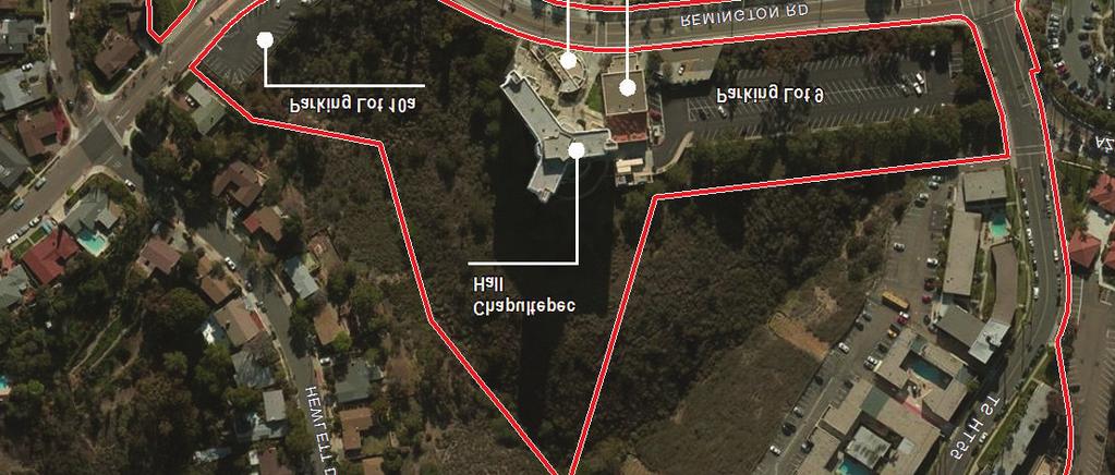
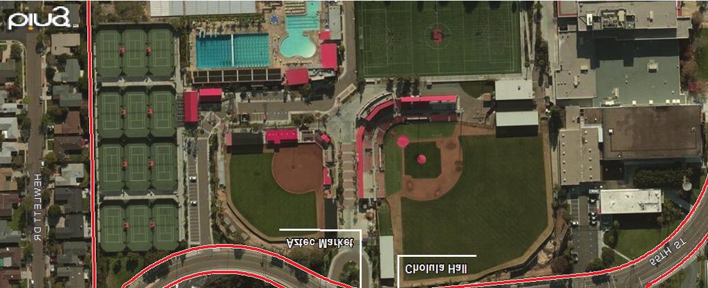
2 4.10 Land Use and Planning residential uses, which is separated from the site by the canyon s steep-sloping orientation. Similarly, the site s east side faces the 55th Street multifamily residential uses and is separated from these uses by another segment of the canyon. The single-family housing generally located to the west of the project site, including those on Hewlett Drive, consists of one- to two-story dwellings on lots with a minimum size of 5,000 square feet. The multifamily housing located along 55th Street to the east of the project site consists of two- to four-story apartment buildings. Aztec Shops, a non-profit auxiliary of SDSU owns all but one of these multifamily properties. Institutional uses to the south and east primarily consist of SDSU athletic and academic facilities. South of the proposed project site and adjacent to the southern side of Remington Road are the SDSU athletic fields, which include Tony Gwynn Stadium, Aztec Softball Field, Fowler Athletics Center, and the Aztec Aquaplex and Peterson Gym, which contains a mix of athletic facilities are classrooms. Aztec Recreation Center is located southeast of the project site and adjacent to the east side of 55th Street (SDSU 2014). Academic buildings, including the International Student Center, and other SDSU uses generally lie to the east of the project site and the athletic uses. As shown on Figure , Project Site Existing Land Uses, the project site is partially developed with Chapultepec Residence Hall (an existing student housing facility), two parking lots, and two small one- to two-story campus buildings. Chapultepec Residence Hall is an 11- story, 545 beds SDSU residence hall located in the approximate center of the project site. The two on-site parking lots are Parking Lot 9 (151-space capacity) and Parking Lot 10A (33-space capacity), which are designated as student and overnight parking lots (SDSU n.d.). One of the on-site campus buildings is the Aztec Market, a one-story convenience market located adjacent to and southeast of Chapultepec Residence Hall. Adjacent to and east of Aztec Market is the two-story Cholula Community Center (SDSU 2014) APPLICABLE PLANS SDSU approved its first campus master plan in 1963, with the purpose of outlining directives for facility placement and providing target square footage for academic, support, or athletic spaces. The original master plan was updated in 1967 and underwent minor revisions throughout the 1970s. In 1997, several major planning efforts were undertaken at the university, one of which was the preparation and adoption of the SDSU Campus Master Plan 2000, a comprehensive, campus-wide build-out strategy. San Diego State University
3 4.10 Land Use and Planning In November 2007, the CSU Board of Trustees approved the 2007 SDSU Campus Master Plan Revision, which provides the framework for implementing SDSU s long-term goals and programs for the campus by identifying needed buildings, facilities, improvements, and services to support campus growth and development from 25,000 full-time equivalent students to a new enrollment of 35,000 full-time equivalent students by the academic year. In December 2007, lawsuits were filed in San Diego Superior Court challenging the adequacy of the environmental impact report (EIR) prepared for the 2007 Campus Master Plan Revision. The lawsuits ultimately resulted in an order directing the CSU Board of Trustees to set aside its prior approval of the 2007 Campus Master Plan. In 2010, the SDSU Campus Master Plan was updated as part of the Plaza Linda Verde Project, which entailed expansion of the campus boundary to the south and east near the intersection of Montezuma Road and College Avenue. Since that time, there have been several minor amendments to the Campus Master Plan. See Figure , Existing Campus Master Plan Map. As shown on the figure, the site of the proposed project is suitable for redevelopment and use as on-campus student residences and would further the campus goal of expanding on-campus student residential opportunities in close proximity to existing student housing and amenities. The proposed project would be compatible with the surrounding campus uses, and would fulfil the planned use of this area and the increased student housing goals set out by SDSU THRESHOLDS OF SIGNIFICANCE Appendix G of the CEQA Guidelines states that a project would result in a potentially significant impact related to land use and planning if the proposed project would: 1. Physically divide an established community. 2. Conflict with any applicable land use plan, policy, or regulation of an agency with jurisdiction over the project (including, but not limited to the general plan, specific plan, local coastal program, or zoning ordinance) adopted for the purpose of avoiding or mitigating an environmental effect. 3. Conflict with any applicable habitat conservation plan or natural community conservation plan. 4. Cause a cumulative considerable land use impact. San Diego State University
4 4.10 Land Use and Planning IMPACTS ANALYSIS Following issuance of the Notice of Preparation for the proposed project, CSU/SDSU received land use and planning related comments concerning the increase in student density near surrounding residential neighborhoods, which are addressed by the analysis presented below. The comments regarding increased student density included project-related impacts from the increased traffic and congestion on surrounding roadways. These traffic and congestion-related impacts from increased student density on the project site are addressed in Section 4.14 Transportation/Circulation and Parking. Would the project physically divide an established community? The proposed project would be developed in three successive phases, and the analyses in this environmental impact report (EIR) addresses the environmental impacts that could arise during construction or operation of each phase. In particular, Phase I would include construction of up to 850 beds on the existing Parking Lot 9, east of the existing Chapultepec Hall; Phase II would include construction of 850 beds to the west of the existing Chapultepec Hall; and Phase III would include construction of 866 beds in buildings that cantilever over the canyon behind Chapultepec Hall. Notwithstanding this phased approach, the proposed project is located entirely within the SDSU campus on a site that is partially developed with existing campus uses. The proposed project would develop dense student housing and associated uses. By directing growth adjacent to an existing student housing facility (Chapultepec Hall), the proposed project would further the preservation of the established residential neighborhoods in the vicinity. Increasing the supply of student housing on the SDSU campus would serve to alleviate the demand for nuisance rentals in the surrounding single-family neighborhoods. In this way, the proposed project would not physically divide an established community, and, in fact, would facilitate the preservation of established communities. The proposed project site is located generally between the single-family residential neighborhood to the west of the campus and the 55th Street multifamily neighborhood east of the project site. An undeveloped canyon separates these two residential areas. The area would not undergo further separation by the proposed project. Accordingly, no impacts from the proposed project relating to the division of an established community would result. Would the project conflict with any applicable plan, policy or regulation of an agency with jurisdiction over the project (including but not limited to the general plan, specific plan, local San Diego State University
5 4.10 Land Use and Planning coastal program, zoning ordinance, etc.) adopted for the purpose of avoiding or mitigating an environmental effect? The proposed project includes an amendment to the existing Campus Master Plan, which would add the proposed student housing and related facilities to the master plan. As such, the proposed project would be consistent with the applicable land use plan. The land use plans and policies of the City of San Diego, including the General Plan, College Area Community Plan, College Area Public Facilities Financing Plan, City of San Diego MSCP and MSCP Subarea Plan, and City of San Diego Municipal Code are not applicable to CSU/SDSU as a state entity. Therefore, because these plans, policies and regulations are not applicable to SDSU, no impact or inconsistency would result. Would the project conflict with any applicable habitat conservation plan or natural community conservation plan? See Section 4.3, Biological Resources, for an analysis of the proposed project s relationship with the San Diego MSCP and the City of San Diego s Subarea Plan. Would the project cause a cumulatively considerable land use impact? Because the proposed project would not physically divide an established community, conflict with any applicable land use plan, or conflict with any applicable habitat conservation or natural community conservation plan, the project s contribution to any potential cumulative impacts would not be cumulatively considerable, and therefore, the project would not cause a significant cumulative land use impact MITIGATION MEASURES The proposed project would not create or contribute to significant impacts related to land use and planning, and therefore, no mitigation is necessary LEVEL OF SIGNIFICANCE AFTER MITIGATION The impacts of the proposed project relative to land use and planning would be less than significant. San Diego State University
6 4.10 Land Use and Planning REFERENCES SDSU (San Diego State University) Campus Map [SDSU Facilities Graphics]. San Diego, California: SDSU Facilities Planning Design & Construction. Spring Accessed January 9, SDSU. n.d. Parking Regulations and Parking Lots. Parking Information. Accessed January 9, San Diego State University
7 Z:\Projects\J624301\MAPDOC\WORKING\EIR\Section 3 MFR = Multi Family Residential SFR = Single Family Residential SDSU Campus and Exisiting Campus Master Plan Boundary Project Site Feet AERIAL SOURCE: BING MAPPING SERVICE SDSU New Student Housing Project EIR 0 Figure Project Vicinity Existing Land Uses
8 4.10 Land Use and Planning INTENTIONALLY LEFT BLANK San Diego State University


9 Document Path: Z:\Projects\j \MAPDOC\DOCUMENT\EIR\Section 4\Fig4_10_02_ProjectSite Exist LUs.mxd SDSU Campus Boundary Feet AERIAL SOURCE: BING MAPPING SERVICE SDSU New Student Housing Project EIR Figure Project Site Existing Land Uses
10 4.10 Land Use and Planning INTENTIONALLY LEFT BLANK San Diego State University

11 Project Site 1. Art - South 2. Hepner Hall 3. Geology - Mathematics - Computer Science 3a. Geology - Mathematics - Computer Science Addition 6. Education 8. Storm Hall 8a. Storm Hall West 8b. Charles Hostler Hall 10. Life Science - South 11. Little Theatre 12. Communication 13. Physics 14. Physics - Astronomy 15. Public Safety 16. Peterson Gymnasium 17. Physical Sciences 18. Nasatir Hall 18a. Aztec Shops Terrace 19. Engineering 20. Exercise and Nutritional Sciences 21. Exercise and Nutritional Sciences Annex 22. CAM Lab (Computer Aided Mechanics) 23. Physical Plant/Boiler Shop 24. Physical Plant 25. Cogeneration Plant 26. Hardy Memorial Tower 27. Professional Studies and Fine Arts 28. Geography Annex 29. Student Services - West 30. Administration 31. Calpulli (Counseling, Disabled and Student Health Services) 32. East Commons 33. Cuicacalli (Dining) 34. West Commons 35. Life Science - North 36. Dramatic Arts 37. Education and Business Administration 38. North Education 38a. North Education Faculty/Staff Club 40. Housing Administration 41. Scripps Cottage 42. Speech, Language and Hearing Sciences 44. Physical Plant/Chill Plant 45. Aztec Shops Bookstore 46. Maya Hall 47. Olmeca Hall (Coeducational Residence) 51. Zura Hall (Coeducational Residence) 52. Conrad Prebys Aztec Student Union 53. Music 54. Love Library 55. Parking Art - North 58. Adams Humanities 59. Student Services - East 60. Chemical Sciences Laboratory 67. Fowler Athletics Center/Hall of Fame 68. Arena Meeting Center 69. Aztec Recreation Center 70. Viejas Arena at Aztec Bowl 70a. Arena Ticket Office 71. Open Air Theater 71a. Open Air Theater Hospitality House 71c. Open Air Theatre Upper Restrooms 71e. Open Air Theater Concessions 71h. Open Air Theater Office 72. KPBS Radio/TV 72a. Gateway Center 72b. Extended Studies Center 73. Racquetball Courts 74. International Student Center 74a. International Student Center Addition - A 74b. International Student Center Addition - B 74t. International Student Center - temporary 76. Love Library Addition/Manchester Hall 77. Tony Gwynn Stadium 78. Softball Stadium 79. Parking Parking Structure 5/Sports Deck 81. Parking Structure Parking Aztec Aquaplex 87. Aztec Tennis Center 88. Parma Payne Goodall Alumni Center 89. Jeff Jacobs JAM Center 90. Arts and Letters 90a. Parking Tenochca Hall (Coed. Residence) 91a. Tula Hall 92. Art Gallery 93. Chapultepec Hall (Coed.Residence) 93a. Cholula Hall 93b. Aztec Market 94. Tepeyac (Coed. Residence) 95. Tacuba (Coed. Residence) 96. Parking Rehabilitation Center 98. Business Services 99. Parking Villa Alvarado Hall (Coed. Residence) 101. Maintenance Garage 101A. Building A 102. Cogeneration/Chill Plant 103. Recreation Field 104. Academic Building A 105. Academic Building B 106. Academic Building C - Education 107. College of Business 109. University Children s Center 110. Growth Chamber 111. Performing Arts Complex 112. Resource Conservation 113. Waste Facility 114. Engineering and Interdisciplinary Sciences 115. Physical Plant/Corporation Yard 116. School of Communication Addition A 117. School of Communication Addition B 118. School of Communication Addition C 119. Engineering Building Addition 135. Donald P. Shiley BioScience Center 167. U-Lot Residence Hall 171. Alvarado Park Research Building Alvarado Park Research Building Alvarado Park Research Building South Campus Plaza Parking Building South Campus Plaza Building South Campus Plaza Building South Campus Plaza Building South Campus Plaza Building South Campus Plaza Building South Campus Plaza Building Physical Plant Shops 208. Betty's Hotdogger 240. Transit Center 302. Field Equipment Storage 303. Grounds Storage 310. EHS Storage Shed 311. Substation D 312. Substation B 313. Substation A 745. Fraternity Row 754. Piedra del Sol (apartments) 761. University House (President s Residence) 925. Granada Apartments 932. University Towers IMPERIAL VALLEY Off-Campus Center, Imperial Valley Campus - Calexico Master Plan Enrollment: 850 FTE Master Plan approved by the Board of Trustees: February 1980 Master Plan Revision approved by the Board of Trustees: September North Classroom Building 2. Administration Building 2a. Art Gallery 3. Auditorium / Classrooms 4. Classrooms Building 5. Library 5a. Library Addition 6. Physical Plant 7. Computer Building 9. Faculty Offices Building East 10. Faculty Offices Building West 20. Student Center 21. Classroom Building/Classroom Building East 22. Classroom Building South 200. Student Affairs (temporary) 201. Classroom Building (temporary) IMPERIAL VALLEY Off-Campus Center, Imperial Valley Campus - Brawley Master Plan Enrollment: 850 FTE Master Plan approved by the Board of Trustees: September Initial Building (Brandt Building ) 102. Academic Building II 103. Academic Building III 104. Library 105. Computer Building 106. Auditorium 107. Administration 108. Academic Building IV 109. Student Center 110. Energy Museum 111. Faculty Office 112. Agricultural Research LEGEND: Existing Facility / Proposed Facility NOTE: Existing building numbers correspond with building numbers in the Space and Facilities Data Base (SFDB) SDSU New Student Housing Project EIR Figure Existing Campus Master Plan
12 4.10 Land Use and Planning INTENTIONALLY LEFT BLANK San Diego State University
4.8 LAND USE AND PLANNING
 4.8 LAND USE AND PLANNING 4.8.1 INTRODUCTION This section describes existing and planned land uses at the Hayward campus and analyzes the impact of implementation of the proposed Master Plan on land uses
2 PROJECT DESCRIPTION
 2 PROJECT DESCRIPTION 2.1 INTRODUCTION 2.1.1 PURPOSE The purpose of this section is to describe the proposed San Diego State University (SDSU) New Student Housing project (proposed project) for the public,
3 CUMULATIVE METHODS AND PROJECTS
 3 CUMULATIVE METHODS AND PROJECTS 3.1 INTRODUCTION This chapter is an introduction to the cumulative impacts analysis contained within each respective environmental impact category subsection of Chapter
New Student Housing Draft EIR Public Meeting
 New Student Housing Draft EIR Public Meeting May 8, 2017 Meeting Overview Purpose of Meeting Sophomore Success Project Objectives Alternatives Project Site/Design Overview Biological Resource Impacts/Mitigation
4.8 Land Use and Planning Environmental Setting Impacts and Mitigation Measures References...4.
 TABLE OF CONTENTS 4.8 Land Use and Planning...4.8-1 4.8.1 Environmental Setting...4.8-1 4.8.2 Impacts and Mitigation Measures...4.8-5 4.8.3 References...4.8-11 FIGURES Figure 4.8-1 Figure 4.8-2 Figure
APPENDIX B. Aesthetics Technical Report
 APPENDIX B Aesthetics Technical Report DRAFT Prepared for: San Diego State University Facilities Planning, Design, and Construction 5500 Campanile Drive San Diego, California 92182-1624 Contact: Laura
4. ENVIRONMENTAL IMPACT ANALYSIS 7. LAND USE AND PLANNING
 4. ENVIRONMENTAL IMPACT ANALYSIS 7. LAND USE AND PLANNING 4.7.1 INTRODUCTION The following analysis discusses the consistency of the Proposed Project with the corresponding land use and zoning designations
2010 Update to the Los Angeles Valley College Facilities Master Plan Board of Trustees February 23, 2011
 Steinberg Architects 2010 Update to the Los Angeles Valley College Facilities Master Plan Board of Trustees February 23, 2011 Educational Master Plan Goals Increase student access Enhance academic programs
No comments related to land use and planning issues were received in response to the Notice of Preparation.
 4.8 LAND USE AND PLANNING This section analyzes the impacts relative to land use and planning that would occur as a result of implementation of the proposed Facilities Master Plan (proposed project). This
TO: CITY COUNCIL DATE: MARCH 23,2009
 Report TO: CITY COUNCIL DATE: MARCH 23,2009 FROM: CITY MANAGER SUBJECT: MASTER DEVELOPMENT PLAN AMENDMENT FOR PASADENA CHRISTIAN SCHOOL AT 1515 NORTH LOS ROBLES AVENUE AND GENERAL PLAN AMENDMENT AND ZONE
APPENDIX A. Notice of Preparation and Comments and Public Scoping Meeting Materials
 APPENDIX A Notice of Preparation and Comments and Public Scoping Meeting Materials NOTICE OF PREPARATION OF DRAFT ENVIRONMENTAL IMPACT REPORT AND INITIAL STUDY; NOTICE OF PUBLIC INFORMATION/SCOPING MEETING;
Preci nct P l ans Figure 56 Campus Aerial Photo, 2008 CAL STATE EAST BAY, HAYWARD CAMPUS MASTER PLAN
 9 Precinct Plans This section contains a detailed discussion of the planning and design concepts for specific areas or precincts of the Cal State East Bay Hayward campus. The Precinct Plans pertain to
3.10 LAND USE SETTING PROJECT SITE EXISTING LAND USE DESIGNATIONS AND ZONING. General Plan Land Use Designations.
 This section of the Draft EIR addresses the existing land uses on and adjacent to the project site and discusses the potential impacts of the proposed project on existing land uses. Key issues addressed
4.1 AESTHETICS INTRODUCTION
 4.1 AESTHETICS 4.1.1 INTRODUCTION This section describes the existing visual setting of the project site and vicinity, identifies associated regulatory requirements, evaluates potential impacts, and identifies
ENVIRONMENTAL INITIAL STUDY BERKELEY CITYWIDE POOLS MASTER PLAN
 ENVIRONMENTAL INITIAL STUDY FOR THE BERKELEY CITYWIDE POOLS MASTER PLAN CITY OF BERKELEY PARKS RECREATION AND WATERFRONT DEPARTMENT SEPTEMBER 1, 2009 ENVIRONMENTAL INITIAL STUDY BERKELEY CITYWIDE POOLS
WASHINGTON COUNTY OREGON
 WASHINGTON COUNTY OREGON July 9, 2009 Revisions to Chapter 2 of the Bethany Community Plan The North Bethany Subarea Plan Exhibit pages 7 and 8 The sections for the Core and Flexible Streets were amended
Goal 1 To establish and follow land use patterns for the long-range development of the campus.
 ELEMENT 4 FUTURE LAND USE Goal 1 To establish and follow land use patterns for the long-range development of the campus. Objective 1A Correct existing incompatible campus land uses. Policy 1A-1 Reduce
PROJECT SUMMARY. University of California, Irvine Humanities Building. Project No FINAL INITIAL STUDY/MITIGATED NEGATIVE DECLARATION
 PROJECT SUMMARY University of California, Irvine Humanities Building Project No. 991077 FINAL INITIAL STUDY/MITIGATED NEGATIVE DECLARATION State Clearinghouse No. 2007011035 March 2007 Humanities Building
REPORT TO BOARD ON PREFERENCES tbp/architecture CCSF Facilities Master Plan, October 23, 2016
 PURPOSE The purpose of this report is to update the Board on the Facilities Master Plan initiative. PROCESS The Board conducted a Study Session about Phase 1 Needs on August 18, 2016. Since that time,
Appendix E Section 4(f) Evaluation
 Evaluation") Appendix E Section 4(f) Evaluation Appendix E Draft Section 4(f) Evaluation E.1 Introduction This appendix addresses a federal regulation known as Section 4(f), which protects parks, recreation areas,
Appendix E Section 4(f) Evaluation Appendix E Draft Section 4(f) Evaluation E.1 Introduction This appendix addresses a federal regulation known as Section 4(f), which protects parks, recreation areas,
THE GEORGE WASHINGTON UNIVERSITY MOUNT VERNON CAMPUS
 THE GEORGE WASHINGTON UNIVERSITY MOUNT VERNON CAMPUS CAMPUS PLAN AMENDMENT AND FURTHER PROCESSING APPLICATION: PRE-HEARING SUBMISSION PELHAM REPLACEMENT PROJECT FILED WITH THE ZONING COMMISSION OF THE
Moreno Valley College: Conceptual Master Planning - Site Analysis Lasselle Street, Moreno Valley, CA 92551
 Master Plan Architect School Name Moreno Valley College District Riverside Community College District Architecture and Urban Design 5898 Blackwelder Street Ground Floor Culver City, CA 90232 T: 310.559.5720
NOTICE OF PREPARATION
 NOTICE OF PREPARATION DATE: January 6, 2016 TO: LEAD AGENCY: Responsible Agencies, Organizations, and Interested Parties Contact: Tyler Barrington, Principal Planner Planning Department Community Development
NOTICE OF AVAILABILITY (NOA) OF A DRAFT ENVIRONMENTAL IMPACT REPORT AND NOTICE OF PUBLIC HEARING 2190 Shattuck Avenue Mixed-Use Project
 OF A DRAFT ENVIRONMENTAL IMPACT REPORT AND NOTICE OF PUBLIC HEARING 2190 Shattuck Avenue Mixed-Use Project") Planning and Development Department Land Use Planning Division NOTICE OF AVAILABILITY (NOA) OF A DRAFT ENVIRONMENTAL IMPACT REPORT AND NOTICE OF PUBLIC HEARING 2190 Shattuck Avenue Mixed-Use Project Notice
Planning and Development Department Land Use Planning Division NOTICE OF AVAILABILITY (NOA) OF A DRAFT ENVIRONMENTAL IMPACT REPORT AND NOTICE OF PUBLIC HEARING 2190 Shattuck Avenue Mixed-Use Project Notice
Goal 1: To Encourage the Orderly, Harmonious and Judicious Use of University Resources in the Development of University Land.
 2.0 Future Land Use Goal 1: To Encourage the Orderly, Harmonious and Judicious Use of University Resources in the Development of University Land. Objective 1.1: Make available future building sites that
STAFF REPORT. December 20, North York Community Council. Director, Community Planning, North York District
 STAFF REPORT December 20, 2005 To: From: Subject: North York Community Council Director, Community Planning, North York District Preliminary Report Application to Amend the Official Plan and Zoning By-law
University of the District of Columbia Van Ness Campus Master Plan Community Open House 3. December 8, 2010
 University of the District of Columbia Van Ness Campus Master Plan Open House 3 December 8, 2010 Introductions Sequence of Work: Campus Master Plan BEGIN: INTRODUCE AND START WORK Project Initiation Team
COMMUNITY DEVELOPMENT SERVICES PLANNING AND BUILDING DEPARTMENT
 COMMUNITY DEVELOPMENT SERVICES PLANNING AND BUILDING DEPARTMENT http://www.edcgov.us/devservices/ PLACERVILLE OFFICE: 2850 Fairlane Court, Placerville, CA 95667 BUILDING (530) 621-5315 / (530) 622-1708
PLANNING APPROVAL & PLANNED UNIT DEVELOPMENT Date: November 2, 2017
 PLANNING APPROVAL & PLANNED UNIT DEVELOPMENT Date: November 2, 2017 DEVELOPMENT NAME LOCATION Mobile Christian School 5900 Cottage Hill Road (North side of Cottage Hill Road, 230 ± West of Freemont Drive
Neighborhood Districts
 NEIGHBORHOOD DISTRICTS SEVEN MAIN DISTRICTS Neighborhood Districts While the Development Plan provides a broad-scale overview of the neighborhood, this section focuses on uses and relationships at the
3.11 LAND USE AND PLANNING
 3.11 LAND USE AND PLANNING This section evaluates the potential environmental impacts that could result from conflicts with land use plans and policies from buildout of the 2018 LRDP. A description of
MATHEMATICAL SCIENCES BUILDING
 Final Focused Tiered Environmental Impact Report State Clearinghouse No. 2002072048 Prepared By: OFFICE OF RESOURCE MANAGEMENT AND PLANNING University of California One Shields Avenue 376 Mrak Hall Davis,
4.8 LAND USE AND PLANNING
 4.8 LAND USE AND PLANNING This section describes the existing land uses on the UCI campus and the surrounding communities and evaluates the potential for land use impacts associated with implementation
NEIGHBORS SOUTHWEST NEIGHBORHOOD MEETING December 17, 2014 BEAVERTON SCHOOL DISTRICT SOUTH COOPER MOUNTAIN HIGH SCHOOL
 NEIGHBORS SOUTHWEST NEIGHBORHOOD MEETING December 17, 2014 AGENDA NEIGHBORHOOD MEETING Design Criteria Review 3 Concepts Discussion Q&A DESIGN CRITERIA NEIGHBORHOOD MEETING IMAGE & IDENTITY CIVIC PRESENCE
TABLE OF CONTENTS. Tables Table UC Davis Park and Open Space Resources
 TABLE OF CONTENTS 4.13 Recreation... 4.13-1 4.13.1 Environmental Setting... 4.13-1 4.13.2 Impacts and Mitigation Measures... 4.13-4 4.13.3 References... 4.13-8 Tables Table 4.13-1 UC Davis Park and Open
Description of Preferred Alternative
 Chapter 2 Description of Preferred Alternative 2.1 Introduction This chapter of the programmatic Sammamish Town Center Sub-area Plan Final EIS provides a more detailed description of the Preferred Alternative
Planning Districts INTRODUCTION
 INTRODUCTION To facilitate detailed examination of development prospects for all areas of the community, Delano has been divided into 14 planning districts. The location of these planning districts is
SECTION 2.0 INTRODUCTION
 SECTION 2.0 INTRODUCTION 2.1 PURPOSE AND SCOPE OF THE EIR Environmental Impact Reports (EIR) are informational documents which wil inform public agency decision-makers and the public generally of the significant
Certificate of Determination EXEMPTION FROM ENVIRONMENTAL REVIEW
 / - \ 11ff SAN FRANCISCO PLANNING DEPARTMENT Certificate of Determination EXEMPTION FROM ENVIRONMENTAL REVIEW 1650 Mission St. Suite 400 San Francisco, CA 94103-2479 Case No.: Reception: Project Address:
Transportation Improvements
 Transportation Improvements 0 0 Volume II of the Final EIS for the DHS Headquarters consolidation at St. Elizabeths includes analysis to transportation improvements for the DHS Headquarters Consolidation
EMERYVILLE PLANNING COMMISSION STAFF REPORT
 EMERYVILLE PLANNING COMMISSION STAFF REPORT Agenda Date: Report Date: April 19, 2012 TO: FROM: SUBJECT: Planning Commission Planning and Building Department Miroo Desai, Senior Planner (ECCL) (UPDR12-001)
Village of Glenview Plan Commission
 Village of Glenview Plan Commission STAFF REPORT January 22, 2019 TO: Chairman and Plan Commissioners CASE #: P2018-047 FROM: Community Development Department CASE MANAGER: Tony Repp, Senior Planner SUBJECT:
This is the East Carolina University Comprehensive Facilities Master Plan Final Draft Plan Review. This workbook reviews the campus draft master plan
 This is the East Carolina University Comprehensive Facilities Master Plan Final Draft Plan Review. This workbook reviews the campus draft master plan first presented on campus on June 29 and June 30, 2011.
UAA School of Engineering Parking Garage Master Plan Amendment. 1. Purpose
 UAA School of Engineering Parking Garage Master Plan Amendment 1. Purpose Since the UAA campus master plan was drafted in 2003, adopted in 2004, and amended in 2009 a number of significant changes regarding
AGENDA 07/14/11 PLANNING COMMISSION Meeting
 AGENDA 07/14/11 PLANNING COMMISSION Meeting MEETING DATE: Thursday, July 14, 2011 MEETING TIME: MEETING PLACE: VIDEO: 5:30 p.m. City Council Chambers, City Hall 350 Main Street El Segundo, California 90245-0989
WHEREAS, after consideration of the evidence presented at the public hearing on January 14, 2010, the Prince George's County Planning Board finds:
 R E S O L U T I O N WHEREAS, the Prince George s County Planning Board has reviewed DDS-600 requesting a departure for the location of two loading spaces without driveway access along Toledo Terrace in
2.18 MU Mixed Use District.
 2.18. Intent - The is established to promote the development of an urban residential environment. The regulations are intended to encourage single family urban residential use and development while allowing
Notice of Preparation of an Environmental Impact Report and Scoping Meeting for the Canyon Lane Roadway Improvements Development Project
 of an Environmental Impact Report and Scoping Meeting for the As the Lead Agency, the County of San Mateo (County) will prepare an Environmental Impact Report (EIR) for the (project), and would like your
LANGAN LANDSCAPE ARCHITECTURE + PLANNING FOR COLLEGES & UNIVERSITIES
 LANGAN LANDSCAPE ARCHITECTURE + PLANNING FOR COLLEGES & UNIVERSITIES CONTACT Philadelphia Pennsylvania 1818 Market Street Suite 3300 Philadelphia PA 19103 215.845.8900 215.845.8901 ST. JOSEPH'S UNIVERSITY
CAMPUS MASTER PLAN DRAFT PLAN UPDATE JANUARY
 NEW MEXICO HIGHLANDS UNIVERSITY CAMPUS MASTER PLAN DRAFT PLAN UPDATE JANUARY 27 2010 MASTER PLANNING GOALS TO BALANCE THE STRATEGIC GOALS OF THE UNIVERSITY WITH THE PHYSICAL CAMPUS through the assessment
ENVIRONMENTAL SETTING
 II. ENVIRONMENTAL SETTING EXISTING CONDITIONS The 208.87-acre Project site is located in the western portion of the City (refer to Figures II-1 and II-2). The Project site comprises Assessor s Parcel Number
Institutional Overlay Zone (IOZ) Regulatory Framework
 Regulatory Framework") Institutional Overlay Zone (IOZ) Regulatory Framework Approved by Portland City Council November 20, 2017 APPLICABILITY All development proposed by Maine Medical Center (MMC) within the boundary of the
Institutional Overlay Zone (IOZ) Regulatory Framework Approved by Portland City Council November 20, 2017 APPLICABILITY All development proposed by Maine Medical Center (MMC) within the boundary of the
6. RECREATION AND OPEN SPACE ELEMENT
 6. RECREATION AND OPEN SPACE Introduction This Recreation and Open Space Element includes Goals, Objectives and Policies (GOP) that apply to the main campus in Gainesville and the Lake Wauburg Recreation
4.0 Future Land Use Element
 4.0 The Florida Agricultural and Mechanical University (FAMU) represents existing and proposed development patterns within the campus boundaries to be coordinated and not conflict with the adjacent areas
Venice Pumping Plant Dual Force Main Project Draft EIR
 City of Los Angeles 5.9 LAND USE PLANS 5.9.1 Environmental Setting Venice Pumping Plant Dual Force Main Project Draft EIR The Project lies within the bounds of Los Angeles County and the City of Los Angeles.
2.4 FUTURE LAND USE ELEMENT Goals, Objectives and Policies
 GOAL 1: To create developmental patterns that direct future growth to appropriate areas on campus, in a manner that promotes the educational mission of the University, the protection of environmentally
242 neighborhoods NEIGHBORHOOD 4: JORDAN AVENUE CORRIDOR
 NEIGHBORHOOD 4: JORDAN AVENUE CORRIDOR Aerial View of Jordan Avenue Corridor EXISTING CHARACTER The Jordan Avenue Corridor is the portion of North Jordan Avenue that extends north from East Third Street
UNIVERSITY OF MICHIGAN:
 Chapter Eight UNIVERSITY OF MICHIGAN: North Campus I. Introduction The University of Michigan currently owns approximately 800 acres of land in the northeast section of Ann Arbor. North Campus refers to
Planning Projects: Highlights
 Planning Projects: Highlights In Process, Under Review, and Under Construction. Transportation Advisory Commission October 23, 2014 Overview of Planning Process PPR Entitlement Design Review Building Permit
Department of Community Development. Planning and Environmental Review Division Revised Notice of Preparation
 Department of Community Development Michael J. Penrose, Acting Director Divisions Building Permits & Inspection Code Enforcement County Engineering Economic Development & Marketing Planning & Environmental
The subject site plan amendment proposes the following revisions to the approved site plan:
 PROPOSED AMENDMENT The subject site plan amendment proposes the following revisions to the approved site plan: 1. The building footprint was modified to accommodate the revised architectural design. 2.
AWH REPORT OF THE PLANNING AND DEVELOPMENT DEPARTMENT FOR APPLICATION FOR REZONING ORDINANCE TO PLANNED UNIT DEVELOPMENT
 AWH REPORT OF THE PLANNING AND DEVELOPMENT DEPARTMENT FOR APPLICATION FOR REZONING ORDINANCE TO PLANNED UNIT DEVELOPMENT MAY 8, 2014 The Planning and Development Department hereby forwards to the Planning
TREASURE COAST REGIONAL PLANNING COUNCIL M E M O R A N D U M. To: Council Members AGENDA ITEM 5H
 TREASURE COAST REGIONAL PLANNING COUNCIL M E M O R A N D U M To: Council Members AGENDA ITEM 5H From: Date: Subject: Staff October 17, 2008 Council Meeting Local Government Comprehensive Plan Review Draft
SAN FRANCISCO PLANNING DEPARTMENT
 PLANNING DEPARTMENT Certificate of Determination EXEMPTION FROM ENVIRONMENTAL REVIEW Case No.: Project Address: Zoning: UMU (Urban Mixed Use) Zoning District 68-X Height and Bulk District Life Science
A. WHAT IS A GENERAL PLAN?
 I. Introduction A. WHAT IS A GENERAL PLAN? A general plan is the planning guideline for the future of a city. It contains goals and policies which regulate urban development, the protection of the natural
14. INTERGOVERNMENTAL COORDINATION ELEMENT
 14. Introduction This Intergovernmental Coordination Element includes Goals, Objectives and Policies (GOP) that apply to the main campus and Alachua County Satellite Properties. The Intergovernmental Coordination
Prepared by: Casey Kempenaar, Senior Planner
 CITY OF CITRUS HEIGHTS PLANNING DIVISION STAFF REPORT PLANNING COMMISSION MEETING September 13, 2017 Prepared by: Casey Kempenaar, Senior Planner REQUEST The applicant requests a Design Review Permit Modification
D3 January 14, 2015 Public Hearing
 D3 January 14, 2015 Public Hearing APPLICANT: DONALD J. BOUCHER, JR. PROPERTY OWNER: D.J.B. SERVICE CENTER, LLC STAFF PLANNER: Kristine Gay REQUEST: A. Conditional Change of Zoning (I-1 to B-2) B. Conditional
3.4 REL: Religious Use District
 3.4 Intent - The s are established to promote and maintain the development facilities for divine worship within the Town of Plainfield. The development of religious facilities or the major expansion of
APPENDIX A NOTICE OF PREPARATION
 APPENDIX A NOTICE OF PREPARATION PROJECT DESCRIPTION Project Location The existing 134-acre San Francisco State University (SFSU) campus is located in the southwestern corner of the City and County of
SPECIFIC PLAN Requirements
 CITY OF LANCASTER PLANNING DEPARTMENT 44933 Fern Avenue, Lancaster, California 93534 (661) 723-6100 SPECIFIC PLAN Requirements Purpose The purpose of a specific plan is to provide for the logical development
Board of Regents SPECIAL MEETING AGENDA AND MATERIAL November 19, 2012
 Board of Regents SPECIAL MEETING AGENDA AND MATERIAL November 19, 2012 Facilities & Land Management Committee Agenda 1 UAA Campus Master Plan Amendment for the Engineering Parking Garage 3 SDA for the
PLANNING COMMISSION. Submitted
 PLANNING COMMISSION City Hall 1275 Main Street El Centro, CA 92243 Submitted PLANNING COMMISSION ACTION ITEM (1844) Meeting: 05/10/16 12:00 AM Department: Community Development Category: Public Hearing
SAN FRANCISCO. x ~ OT`s 0~5` PLANNING DEPARTMENT. Certificate of Determination COMMUNITY PLAN EVALUATION PROJECT DESCRIPTION CEQA DETERMNATION
 y;~~~ counr~on u "'s' 9z x ~ OT`s 0~5` SAN FRANCISCO PLANNING DEPARTMENT COMMUNITY PLAN EVALUATION Case No.: Project Address: Zoning: RTO-M (Residential Transit Oriented-Mission) Use District Calle 24
Meeting Display Boards for Public Hearing on the Wilson Transfer Station Project held Tuesday, February 18, 2014.
 Meeting Display Boards for Public Hearing on the Wilson Transfer Station Project held Tuesday, February 18, 2014. Board 1: Welcome Welcome to the Wilson Transfer Station Project Public Hearing. The purpose
Boise State University October 8 - Workshop # 2. MASTER PLAN UPDATE Executive Committee Ayers Saint Gross
 Boise State University October 8 - Workshop # 2 MASTER PLAN UPDATE Executive Committee Ayers Saint Gross WORKSHOP AGENDA 01 WORK SESSION SUMMARY Program clarifications res life, trans, STEM Concept Plan
210 PART 2 LANDSCAPE DESIGN GUIDELINES AND PRECINCT PLANS
 Appendix The consolidated development parameters matrix contains key development guidelines for all potential building sites identified in the plan. It prescribes the following: total area of each development
2.7 ac park. TOTAL 5,403 DU 1,297,900 sf 1,105,450 sf 3.87 ac 5,563 DU 1,121,200 sf 1,105,450 sf 3.87 ac
 PLAN AMENDMENT 2013-I-B1: SEVEN CORNERS SPECIAL STUDY Summary of Pre-staffing Comments Planner: Bernard Suchicital bsuchi@fairfaxcounty.gov (703) 324-1254 Background On October 29, 2013, the Board of Supervisors
ARLINGTON COUNTY, VIRGINIA
 ARLINGTON COUNTY, VIRGINIA County Board Agenda Item Meeting of July 21, 2012 DATE: July 12, 2012 SUBJECT: SP #416 SITE PLAN AMENDMENT to modify condition #6 to eliminate requirement to provide a pedestrian
Campus Sign Plan. Adopted by the Campus Planning Committee Adopted: June 26, 2006 Revised: April 14, 2016
 Campus Sign Plan Adopted by the Campus Planning Committee Adopted: June 26, 2006 Revised: April 14, 2016 INTRODUCTION Oregon State University requires an effective system of visual communication that projects
4 January 11, 2012 Public Hearing APPLICANT:
 . 4 January 11, 2012 Public Hearing APPLICANT: MID-ATLANTIC AUTO PROPERTY OWNER: DZR, LLC STAFF PLANNER: Leslie Bonilla REQUEST: Conditional Use Permit (truck rental, automobile service, and automotive/bulk
12.0 LAND USE AND PLANNING
 This section describes the existing and proposed land uses and land use designations on each of the project sites and surrounding properties, and analyzes the potential for the project to conflict with
Chesapeake Bay Critical Area Conservation Plan
 The Maryland-National Capital Park and Planning Commission Prince George s County Planning Department Development Review Division 301-952-3530 Note: Staff reports can be accessed at www.mncppc.org/pgco/planning/plan.htm.
Gold Line Bus Rapid Transit Transit Oriented Development (BRTOD) Helmo Station Area Plan
 Helmo Station Area Plan") Appendix F Gold Line Bus Rapid Transit Transit Oriented Development (BRTOD) Helmo Station Area Plan Introduction and Purpose of the Plan The Gold Line Bus Rapid Transit facility is an eleven-mile dedicated
Appendix F Gold Line Bus Rapid Transit Transit Oriented Development (BRTOD) Helmo Station Area Plan Introduction and Purpose of the Plan The Gold Line Bus Rapid Transit facility is an eleven-mile dedicated
Boise State University October 7-8 Workshop # 2 MASTER PLAN UPDATE. Ayers Saint Gross
 Boise State University October 7-8 Workshop # 2 MASTER PLAN UPDATE Ayers Saint Gross WORKSHOP AGENDA 01 PROCESS UPDATE 02 WORKSHOP 1 SUMMARY Issues + Opportunities Plan-Program Elements 03 PLANNING FRAMEWORK
CAMPUS MASTER PLAN, AMENDMENTS
 CAMPUS MASTER PLAN AMENDMENTS CAMPUS MASTER PLAN, 2015-2025 AMENDMENTS OCTOBER 2016 PLANNING, DESIGN & CONSTRUCTION DIVISION AMENDMENTS UNIVERSITY OF FLORIDA COMPREHENSIVE MASTER PLAN OCTOBER 2016 1. Acreage
DRAFT ENVIRONMENTAL IMPACT REPORT NORTH HOLLYWOOD-VALLEY VILLAGE COMMUNITY PLAN AREA
 Environmental Review City Hall 200 N. Spring Street, Room 750 Los Angeles, CA 90012 DRAFT ENVIRONMENTAL IMPACT REPORT NORTH HOLLYWOOD-VALLEY VILLAGE COMMUNITY PLAN AREA The Plaza at The Glen Mixed Use
UMBC Facilities Management. UMBC Facilities Master Plan Update
 Management UMBC 2009-2019 February 19, 2010 A is the Vision for buildings, lands, open spaces and infrastructure Framework for the shape and development of the campus built environment driven by the University
a) Inventory of all existing privately-owned, state-owned, or local governmentowned recreational facilities and open spaces within the context area
 Inventory of all existing privately-owned, state-owned, or local governmentowned recreational facilities and open spaces within the context area") 8.0 RECREATION AND OPEN SPACE ELEMENT (1) DATA REQUIREMENTS a) Inventory of all existing privately-owned, state-owned, or local governmentowned recreational facilities and open spaces within the context
8.0 RECREATION AND OPEN SPACE ELEMENT (1) DATA REQUIREMENTS a) Inventory of all existing privately-owned, state-owned, or local governmentowned recreational facilities and open spaces within the context
ARLINGTON COUNTY, VIRGINIA. County Board Agenda Item Meeting of June 16, 2018
 ARLINGTON COUNTY, VIRGINIA County Board Agenda Item Meeting of June 16, 2018 DATE: June 7, 2018 SUBJECT: Z-2604-18-1 Rezoning from R-6 and R-5 Single Family Residential Districts to S-3A Special District
4 LAND USE DESIGNATIONS
 4 LAND USE DESIGNATIONS Chapter 4 describes the land use designations and densities that will implement the development vision for North Burlingame outlined in Chapter 3. Land use densities are described
Report to City Council
 Attachment 4 BUDGET OFFICER CITY ATTORNEY APPROVALS CITY MANAGER Report to City Council TO: FROM: Mayor and City Council John C. Terell, Community and Economic Development Director AGENDA DATE: June 24,
DEPARTURE FROM DESIGN STANDARDS DDS-586
 The Maryland-National Capital Park and Planning Commission Prince George s County Planning Department Development Review Division 301-952-3530 Note: Staff reports can be accessed at www.mncppc.org/pgco/planning/plan.htm.
3.0 Cumulative Scenario and Methodology. 3.0 Cumulative Scenario and Methodology
 3.0 Cumulative Scenario and Methodology Under the CEQA Guidelines, a cumulative impact consists of an impact which is created as a result of the combination of the project evaluated in the environmental
1. Parks & Recreation Neighborhood Parks Community Parks Special Use Sites 2. Open Space 3. Trails
 Appendix A: Park Classifications The intent of parks and recreation classifications is to aid in making acquisition and design decisions for park sites, facilities and the organization of recreation space
City of San Ramon. Zoning Ordinance. Adopted: October 27, Latest Revisions Effective: March 28, 2018
 City of San Ramon Zoning Ordinance Adopted: October 27, 2015 Latest Revisions Effective: March 28, 2018 City of San Ramon 7000 Bollinger Canyon Road San Ramon, California 94583 [Page intentionally left
12 Intergovernmental Coordination
 Intergovernmental Coordination Supporting Data The purpose of the Intergovernmental Coordination Element is to identify and resolve incompatible goals, objectives, policies and development proposed in
Notice of Preparation and Notice of Public Scoping Meeting. At Dublin Project
 Notice of Preparation and Notice of Public Scoping Meeting Date January 17, 2018 To Project Title Project Application Number Project Location Project Applicant Contact For questions or submitting comments.
Regency Developments. Urban Design Brief. Holyrood DC2 Rezoning
 Regency Developments Urban Design Brief Holyrood DC2 Rezoning Stantec Consulting Ltd. 7-31-2017 1. Overview Regency Developments intends to rezone the lands located at 8510 and 8511 93 Avenue, within the
U n i v e r s i t y o f S o u t h C a r o l i n a A i k e n. Land Plan Study
 U n i v e r s i t y o f S o u t h a r o l i n a A i k e n Land Plan Study 06.27.2008 Goals ampus Growth Develop a Land Plan that allows for the orderly expansion of the campus over the next ten years and