CAMPUS MASTER PLAN, AMENDMENTS
|
|
|
- Chester Turner
- 5 years ago
- Views:
Transcription

1 CAMPUS MASTER PLAN AMENDMENTS CAMPUS MASTER PLAN, AMENDMENTS OCTOBER 2016 PLANNING, DESIGN & CONSTRUCTION DIVISION
2 AMENDMENTS UNIVERSITY OF FLORIDA COMPREHENSIVE MASTER PLAN OCTOBER Acreage Chart of Land Use Changes Contents/Sections 2. Relationship of Amendments to Public Facilities in Context Area 3. Land Use Amendment FLU-16-1 FLU-16-2 Garage Future Land Use maps Figures 2-1 (current & proposed) NEXUS Engineering Future Land Use maps Figures 2-1 (current & proposed) 4. Replacement Maps Figure 2-1 Figure 2-2 Future Land Use Future Building Site by Future Land Use Campus Master Plan Amendments October 2016 Page 2 of 9
3 Section 1 ACREAGE CHART OF LAND USE CHANGES UF Main Campus Land Use Classification As Adopted 2025 Acres FLU-16-1 FLU-16-2 Total Acreage as Amended 2016 Academic Academic - Outdoor Active Recreation Active Recreation Outdoor Buffer Conservation Cultural Housing Parking Road Support Urban Park Utility Total Campus Master Plan Amendments October 2016 Page 3 of 9
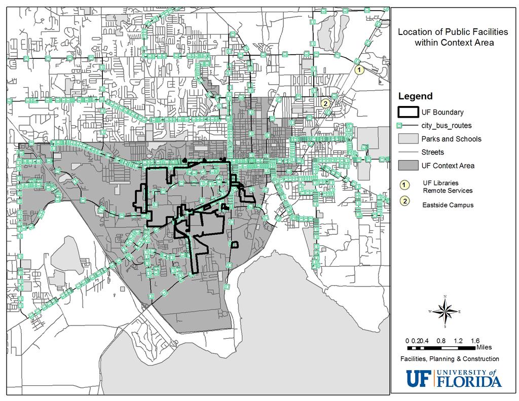
4 SECTION 2 RELATIONSHIP OF AMENDMENTS TO PUBLIC FACILITIES IN CAMPUS MASTER PLAN CONTEXT AREA Campus Master Plan Amendments October 2016 Page 4 of 9
5
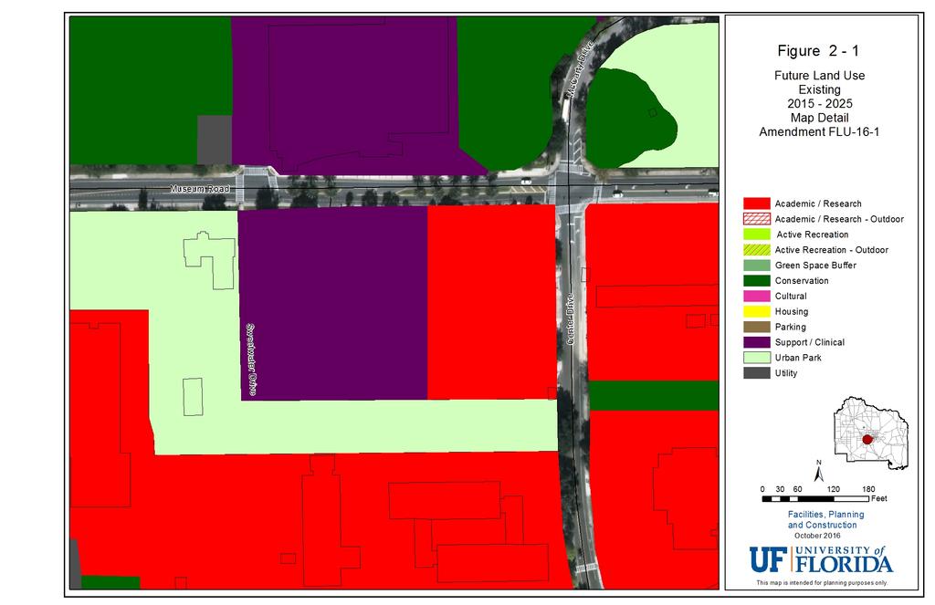
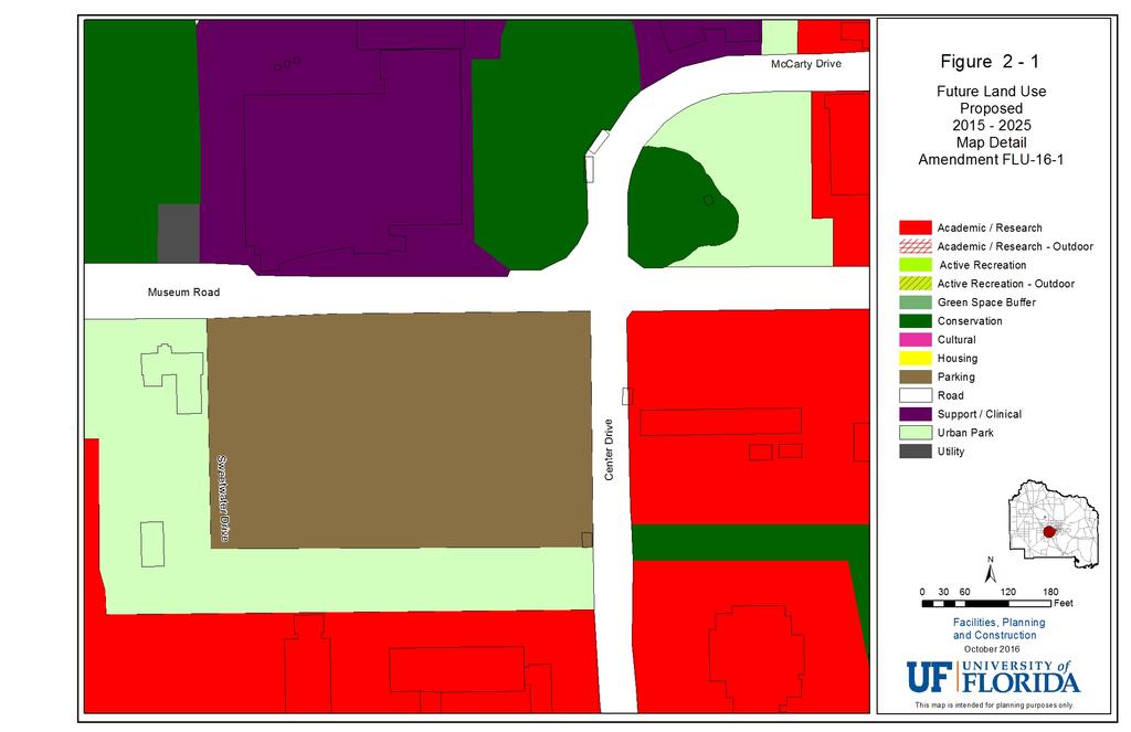
6 Section 3 MAP AMENDMENT FLU-16-1 Parking Garage - This proposed land use change is necessitated by the change in location from the McCarty parking lot to the Aerospace lot. Figure Title 2-1 Future Land Use 2-2 Future Land Use and Buildings 13-1 Future Building Locations EXISTING LAND USE / ACRES PROPOSED LAND USE /ACRES Support /-2.4 Parking / +2.4 Academic /-1.6 Parking /+1.6 PUBLIC FACILITIES IMPACT There are no public facilities impacts with this amendment. The project is consistent with the Campus Development Agreement. LANDUSE COMPATIBILITY The proposed building location is currently designated as Support in the Campus Master Plan. This land uses was consistent with the intent of the property in question at the time of the Plan s adoption. However, since then it has been recognized that the options chosen for the newest parking garage are not suitable for the size of the garage need. Thus, this alternative, larger site has been chosen where both the footprint and the height will more appropriately scale in context with existing and planned buildings. This site borders Museum Road on the north, an engineering complex (Academic) to the south and Center Drive to the east. CONSISTENCY WITH GOP S A review of the goals, objectives and policies (GOP s) of the Campus Master Plan indicates that the proposed land use change is consistent with the Master Plan and supports the following objectives and policies: Future Land Use Policy 1.1.4: The Future Land Use map and Future Building Sites map shall be used to identify available land and redevelopment sites suitable for development on the main campus to accommodate future growth, define future infill opportunities and conserve existing resources. Future Land Use maps shall identify available land for development on university satellite properties consistent with the list of projects in Table 13-1 and the Capital Improvements Element. This inventory of available sites shall be updated on a periodic basis, no less than once every five years, to reflect changes in status. Policy 1.1.5: The selection of building sites, refinement of future building site footprints and design of associated site improvements within designated future land use areas shall: Conform to the Future Land Use definition in Policy 1.1, Future Land Use Element; Campus Master Plan Amendments October 2016 Page 6 of 9
7 Preserve or satisfactorily realign pedestrian connections and future shared use path alignments that appear on the Urban Design Connections Map in the Urban Design Element; Create functional compatibility between adjacent facilities within the contiguous future land use area and along the boundaries between different future land use classifications, particularly when a new structure is adjacent to a Conservation land use as addressed in the Conservation Element, Policy 1.3; Create building groupings that frame functional open space when encouraged by the Future Land Use definition; Provide compatibility of size, scale, orientation and materials with existing structures in the Registered Historic District and its impact area as presented on the Historic District Area of Impact Map in the Urban Design Element; Group similar or associated programs in close proximity to one another in order to facilitate interaction between the facility occupants, particularly in support of interdisciplinary or multidisciplinary teaching and research; Concentrate buildings in centers of development to accommodate convenient pedestrian access between buildings, provide a critical mass that facilitates associated support activities (parking, transit, food service, etc.) and retain open spaces; and Avoid locations of undesirable soils or topography by conducting appropriate soil and geotechnical evaluations during site selection and design. Policy 1.2.1: Modification of future land use classifications shown in the most recently adopted Future Land Use Map (Figure 2-1), require an amendment to the Campus Master Plan to be processed consistent with Chapter , Florida Statutes and applicable University of Florida Operating Memorandum. Parking Land Use Policy 2.5.2: Major new parking facilities shall be provided on the main campus as multi-story parking garage structures designed to efficiently use campus land resources. These structures shall be provided consistent with the Figure 2-1, Future Land Use map and Figure 13-1, Future Building Sites map with priority consideration for the locations depicted on Figure 8-7. Parking structures shall be encouraged to include non-parking liner building uses, and the Future Land Use designations shall be interpreted to provide flexibility that encourages this mixed-use approach to structured parking. Policy 2.5.4: Campus parking shall be strategically located throughout the campus and along the campus periphery such as the vicinity of Hull Road, SW 34th Street, Radio Road, University Avenue, SW 13th Street, SW 16th Avenue and Archer Road with transit connections to interior campus locations. Policy 2.6.2: The University shall employ a certified traffic engineer on staff and/or as an annual services contractor to evaluate, recommend and oversee implementation of routine traffic counts and modifications of traffic circulation, pedestrian and bicycle facilities, traffic signals, signs, markings and other such traffic issues. Campus Master Plan Amendments October 2016 Page 7 of 9
8
9
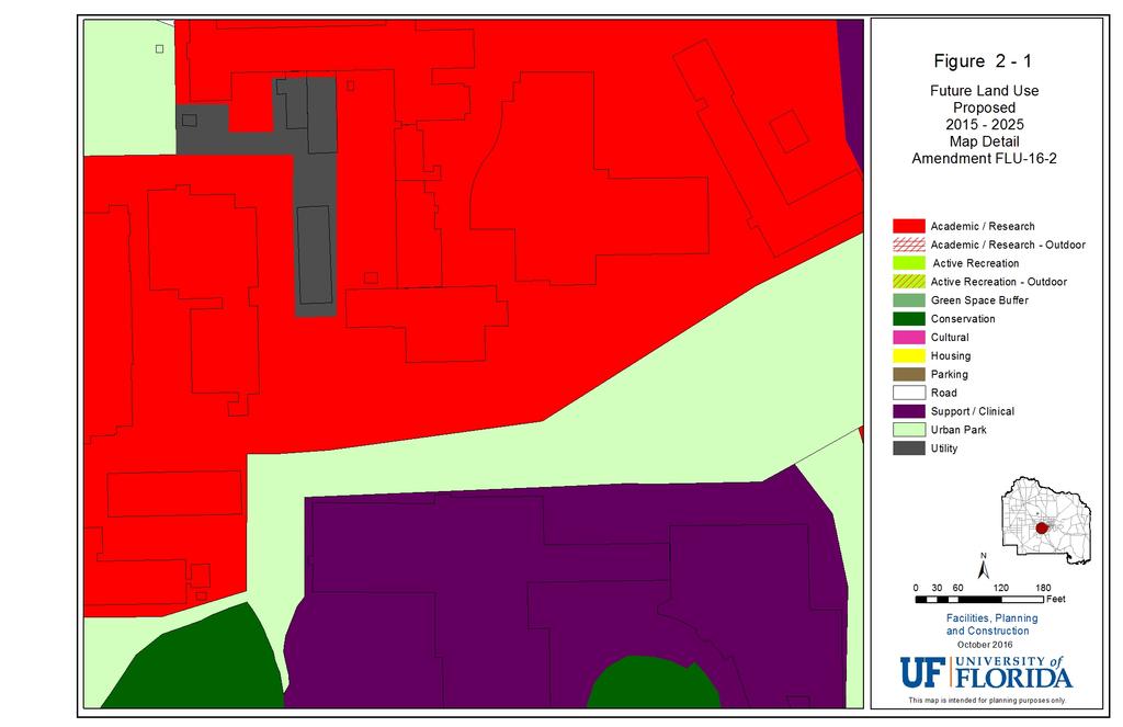
10 MAP AMENDMENT FLU-16-2 NEXUS - This proposed land use change is necessitated by the increased footprint of the NEXUS building. Figure Title 2-1 Future Land Use 2-2 Future Land Use and Buildings EXISTING LAND USE / ACRES PROPOSED LAND USE /ACRES Urban Park /-.5 Academic / +.5 PUBLIC FACILITIES IMPACT There are no public facilities impacts with this amendment. The project is consistent with the Campus Development Agreement. LANDUSE COMPATIBILITY A portion of the selected building location is currently designated as Urban Park in the Campus Master Plan. This land use was consistent at the time of the Plan s adoption. However, since then the building program has increased and as such the land use must be changed to make the footprint consistent with the new building. All surrounding land uses remain the same, with just a small reduction in Urban Park CONSISTENCY WITH GOP S A review of the goals, objectives and policies (GOP s) of the Campus Master Plan indicates that the proposed land use change is consistent with the Master Plan and supports the following objectives and policies: Academic Facilities Element Goal 1: Provide Sufficient Facilities for Academic and Research Endeavors Across All Colleges and Consistent with the University s Academic Strategic Plan. Policy 1.1.7: Facilitate collaboration between university academics and operations to use the campus as a living laboratory and educational opportunity, particularly as a model of sustainability-related application, research and teaching. Future Land Use Element Policy 1.1.5: The selection of building sites, refinement of future building site footprints and design of associated site improvements within designated future land use areas shall: Preserve or satisfactorily realign pedestrian connections and future shared use path alignments that appear on the Urban Design Connections Map in the Urban Design Element; Create functional compatibility between adjacent facilities within the contiguous future Campus Master Plan Amendments October 2016 Page 8 of 9
11 land use area and along the boundaries between different future land use classifications, particularly when a new structure is adjacent to a Conservation land use as addressed in the Conservation Element, Policy 1.3; Create building groupings that frame functional open space when encouraged by the Future Land Use definition; Provide compatibility of size, scale, orientation and materials with existing structures in the Registered Historic District and its impact area as presented on the Historic District Area of Impact Map in the Urban Design Element; Group similar or associated programs in close proximity to one another in order to facilitate interaction between the facility occupants, particularly in support of interdisciplinary or multidisciplinary teaching and research; Concentrate buildings in centers of development to accommodate convenient pedestrian access between buildings, provide a critical mass that facilitates associated support activities (parking, transit, food service, etc.) and retain open spaces; and Campus Master Plan Amendments October 2016 Page 9 of 9
12
13
14
15
16
Goal 1: To Encourage the Orderly, Harmonious and Judicious Use of University Resources in the Development of University Land.
 2.0 Future Land Use Goal 1: To Encourage the Orderly, Harmonious and Judicious Use of University Resources in the Development of University Land. Objective 1.1: Make available future building sites that
DRAFT MAP AMENDMENT FLU 04-4
 DRAFT MAP AMENDMENT FLU 04-4 SW 24 TH AVENUE ROADWAY CORRIDOR The University of Florida participates with the Metropolitan Transportation Planning Organization (MTPO) in its responsibilities for the continuing,
4.0 Future Land Use Element
 4.0 The Florida Agricultural and Mechanical University (FAMU) represents existing and proposed development patterns within the campus boundaries to be coordinated and not conflict with the adjacent areas
ALBEMARLE COUNTY CODE CHAPTER 18 ZONING SECTION 20A NEIGHBORHOOD MODEL - NMD
 CHAPTER 18 ZONING SECTION 20A NEIGHBORHOOD MODEL - NMD Sections: 20A.1 PURPOSE AND INTENT 20A.2 STATUS AS A PLANNED DEVELOPMENT DISTRICT 20A.5 CODES OF DEVELOPMENT 20A.6 PERMITTED USES 20A.7 RESIDENTIAL
6. RECREATION AND OPEN SPACE ELEMENT
 6. RECREATION AND OPEN SPACE Introduction This Recreation and Open Space Element includes Goals, Objectives and Policies (GOP) that apply to the main campus in Gainesville and the Lake Wauburg Recreation
UAA School of Engineering Parking Garage Master Plan Amendment. 1. Purpose
 UAA School of Engineering Parking Garage Master Plan Amendment 1. Purpose Since the UAA campus master plan was drafted in 2003, adopted in 2004, and amended in 2009 a number of significant changes regarding
6.0 Recreation and Open Space
 6.0 Recreation and Open Space Goal 1: Provide Recreation and Open Space Facilities In Close Proximity to the University Population to Support Healthy Lifestyles, and Adequately and Efficiently Serve the
14. INTERGOVERNMENTAL COORDINATION ELEMENT
 14. Introduction This Intergovernmental Coordination Element includes Goals, Objectives and Policies (GOP) that apply to the main campus and Alachua County Satellite Properties. The Intergovernmental Coordination
The West Vaughan Employment Area Secondary Plan Policies
 Part 2: The West Vaughan Employment Area Secondary Plan Policies 2.1 General Policies It is the policy of Council: 2.1.1. That the West Vaughan Employment Area (the WVEA), identified on Schedule 1, will
Appendix C: Interim Mixed-Use Evaluation Criteria
 Appendix C: Interim Mixed-Use Evaluation Criteria C-1 Appendix C: Interim Mixed-Use Evaluation Criteria PURPOSE: The implementation of numerous policies contained within the Master Plan hinges on the creation
AWH REPORT OF THE PLANNING AND DEVELOPMENT DEPARTMENT FOR APPLICATION FOR REZONING ORDINANCE TO PLANNED UNIT DEVELOPMENT
 AWH REPORT OF THE PLANNING AND DEVELOPMENT DEPARTMENT FOR APPLICATION FOR REZONING ORDINANCE TO PLANNED UNIT DEVELOPMENT MAY 8, 2014 The Planning and Development Department hereby forwards to the Planning
Staff Report and Recommendation
 Community Planning and Development Planning Services 201 W. Colfax Ave., Dept. 205 Denver, CO 80202 p: 720.865.2915 f: 720.865.3052 www.denvergov.org/cpd TO: City Council Neighborhoods and Planning Committee
2.4 FUTURE LAND USE ELEMENT Goals, Objectives and Policies
 GOAL 1: To create developmental patterns that direct future growth to appropriate areas on campus, in a manner that promotes the educational mission of the University, the protection of environmentally
CITY OF CHARLOTTESVILLE, VIRGINIA CITY COUNCIL AGENDA
 CITY OF CHARLOTTESVILLE, VIRGINIA CITY COUNCIL AGENDA Agenda Date: December 16, 2013 Action Required: Adoption of Resolution Presenter: Staff Contacts: Title: James E. Tolbert, AICP, Director of NDS James
RECREATION AND OPEN SPACE ELEMENT GOALS, OBJECTIVES, AND POLICIES
 RECREATION AND OPEN SPACE ELEMENT GOALS, OBJECTIVES, AND POLICIES Goal 7 To provide park facilities, recreation programs, and open space resources that are safe, adequate, and accessible to all City residents,
CITY OF PUYALLUP. Background. Development Services
 CITY OF PUYALLUP Development Services 333 South Meridian Puyallup WA 98371 To: City Council From: Katie Baker, AICP, Planning Division Re: South Hill Neighborhood Plan Adoption Date: (Meeting date: February
WHEREAS, the current Comprehensive Plan was adopted in 2005; and
 RESOLUTION 2018-06 RESOLUTION TO AMEND THE CITY S COMPREHENSIVE PLAN TO (1) AMEND CHAPTER 4 TO ADD A SPECIAL REVITALIZATION DISTRICT FOR EDUCATION AND ECONOMIC DEVELOPMENT ; (2) DESIGNATE ON THE FUTURE
11.0 TRANSPORTATION ELEMENT
 11.0 TRANSPORTATION ELEMENT Transit, Circulation and Parking Sub-Element: For all campuses, FIU's goal is to increase multimodal access. In combination with other measures - such as the development of
Goal 1: Maintain a Coherent, Compatible and Aesthetically Pleasing Campus Environment that is Conducive to Learning.
 1.0 Urban Design Goal 1: Maintain a Coherent, Compatible and Aesthetically Pleasing Campus Environment that is Conducive to Learning. Objective 1.1: Utilize design standards for the construction, renovation
Planned Development Review Revisions (Project No. PLNPCM )
") Planned Development Review Revisions (Project No. PLNPCM2014-00139) Standard residential development Planned Development Example: Smaller lot sizes than what is allowed to create open space amenity. What
Planned Development Review Revisions (Project No. PLNPCM2014-00139) Standard residential development Planned Development Example: Smaller lot sizes than what is allowed to create open space amenity. What
Goal 1 To establish and follow land use patterns for the long-range development of the campus.
 ELEMENT 4 FUTURE LAND USE Goal 1 To establish and follow land use patterns for the long-range development of the campus. Objective 1A Correct existing incompatible campus land uses. Policy 1A-1 Reduce
City of Heath. Town Center Concept
 In the give-and-take of getting projects designed, financed, and approved, the famous refrain from the film Field of Dreams is heard often: if you build it, they will come. From the perspective of the
FLORIDA STATE UNIVERSITY MASTER PLAN 3 Urban Design
 FLORIDA STATE UNIVERSITY MASTER PLAN 3 Urban Design 2008 UPDATE URBAN DESIGN ELEMENT NOTE: Unless otherwise noted, the goals, objectives and policies contained in this element shall Guide development of
Royal Thai Embassy Ottawa. Major Zoning Amendment Proposal for 180 Island Park Drive. Planning Rationale
 Royal Thai Embassy Ottawa Major Zoning Amendment Proposal for INTRODUCTION This has been prepared in support of a Major Zoning Amendment for lands located at and currently occupied by Royal Thai Embassy.
CHARLES PUTMAN CHARLES PUTMAN AND ASSOCIATES, INC
 MEMORANDUM CHARLES PUTMAN & ASSOCIATES, INC. LAND DEVELOPMENT CONSULTANTS PLANNING ZONING PERMITTING 4722 NW Boca Raton Boulevard, Suite C-106 Boca Raton, Florida 33431 Phone: 561/994-6411 FAX: 561/994-0447
4.1.3 LAND USE CATEGORIES
 4.1.3 LAND USE CATEGORIES a. City Center District The City Center District incorporates the existing character and mix of uses in downtown Belmont to encourage redevelopment and new development in keeping
4.0 Future Land Use Element
 4.0 PURPOSE The purpose of this element is to describe the existing and future land use pattern to be developed on the University and to address how this land use pattern will be coordinated with that
Exhibit A-1: Future Land Use Element Goals, Objectives, and Policies
 Exhibit A-1: Future Land Use Element Goals, Objectives, and Policies GOAL 1 IMPROVE THE QUALITY OF LIFE AND ACHIEVE A SUPERIOR, SUSTAINABLE, DEVELOPMENT PATTERN IN THE CITY BY CREATING AND MAINTAINING
12 Intergovernmental Coordination
 Intergovernmental Coordination Supporting Data The purpose of the Intergovernmental Coordination Element is to identify and resolve incompatible goals, objectives, policies and development proposed in
Commercial Development Standards. City of Homestead
 Commercial Development Standards City of Homestead Presentation Outline Introductions Purpose and Intent Objectives Administrative Process Established Districts Design Standards Purpose and Intent Supplement
TREASURE COAST REGIONAL PLANNING COUNCIL M E M O R A N D U M. To: Council Members AGENDA ITEM 5H
 TREASURE COAST REGIONAL PLANNING COUNCIL M E M O R A N D U M To: Council Members AGENDA ITEM 5H From: Date: Subject: Staff October 17, 2008 Council Meeting Local Government Comprehensive Plan Review Draft
VILLAGE OF CLEMMONS PLANNING BOARD DRAFT STAFF REPORT
 VILLAGE OF CLEMMONS PLANNING BOARD DRAFT STAFF REPORT PETITION INFORMATION Docket # C-226 Staff Megan Ledbetter Petitioner(s) JBJH Properties, LLC Owner(s) JBJH Properties, LLC Subject Property 5892-49-1766
EXISTING COMPREHENSIVE PLAN
 EXISTING COMPREHENSIVE PLAN Town Center Land Use Element: V. LAND USE POLICIES Town Center Mercer Island's business district vision as described in "Your Mercer Island Citizen-Designed Downtown" was an
NORTHEAST DISTRICT. Description. Opportunities
 VI plan and major recommendations district plans northeast disrict NORTHEAST DISTRICT Description The Northeast District comprises approximately 38 acres. It is bounded by Campus Creek to the north, the
STAFF REPORT. To: Planning Commission Meeting Date: April 12, City of North Las Vegas
 STAFF REPORT #3) AMP-02-17 AMENDMENT TO THE COMPREHENSIVE MASTER PLAN PUBLIC HEARING To: Planning Commission Meeting Date: April 12, 2017 Item: AMP-02-17 Prepared By: Johanna Murphy GENERAL INFORMATION:
CONTENTS 8.0 LAND USE 8.1 GENERAL LAND USE 8.2 RESIDENTIAL 8.3 MIXED USE 8.4 COMMERCIAL 8.5 EMPLOYMENT LANDS
 8-2 Land Use 8.0 LAND USE CONTENTS 8.1 GENERAL LAND USE 8.1.1 Uses provided for in all Land Use Designations 8.1.2 Uses prohibited in Hazardous Lands, Hazardous Sites and Special Policy Areas 8.1.3 Uses
PSRC REVIEW REPORT & CERTIFICATION RECOMMENDATION
 PSRC REVIEW REPORT & CERTIFICATION RECOMMENDATION KITSAP COUNTY COUNTYWIDE PLANNING POLICIES July 2, 2012 BACKGROUND A major emphasis of the Washington State Growth Management Act (GMA) is the need to
This page has been intentionally left blank.
 This page has been intentionally left blank. Chapter 3 3-2 3. Employment 3.A Niagara Economic Gateway 3.A.1 General The Niagara Economic Gateway comprises: a) The Gateway Economic Zone which includes all
[THIS PAGE INTENTIONALLY LEFT BLANK]
![[THIS PAGE INTENTIONALLY LEFT BLANK]](/thumbs/77/76526040.jpg "[THIS PAGE INTENTIONALLY LEFT BLANK]") 1-1 LAND USE [THIS PAGE INTENTIONALLY LEFT BLANK] TABLE OF CONTENTS INTRODUCTION... 7 1-1. GOAL: TO DEVELOP AND MAINTAIN A WELL-BALANCED COMMUNITY WITH A VARIETY OF LAND USES THAT ARE COMPATIBLE WITH EACH
1-1 LAND USE [THIS PAGE INTENTIONALLY LEFT BLANK] TABLE OF CONTENTS INTRODUCTION... 7 1-1. GOAL: TO DEVELOP AND MAINTAIN A WELL-BALANCED COMMUNITY WITH A VARIETY OF LAND USES THAT ARE COMPATIBLE WITH EACH
SECTION 1 Introduction...1. SECTION 2 Regional Context Criteria for Planning Districts Description of Planning District...
 Table of Contents SECTION 1 Introduction...1 SECTION 2 Regional Context...2 2.1 - Criteria for Planning Districts...2 2.2 - Description of Planning District...2 SECTION 3 Goals & Objectives...5 SECTION
Montgomery Auto Sales Park Preliminary Plan A, Site Plan , and Site Plan
 Montgomery Planning Area 3 11/8/2018 Montgomery Auto Sales Park Preliminary Plan 11985027A, Site Plan 820140130, and Site Plan 820140140 Agenda item 4 Montgomery Auto Sales Park 11/8/2018 1 Site Vicinity
38 Queen s University Campus Master Plan Part 1
 38 Queen s University Campus Master Plan Part 1 46 The Campus at the City Scale Chapter 4 The Campus at the City Scale 39 Queen s is an urban University centrally located in Kingston. Decisions made by
REZONING GUIDE. Zone Map Amendment (Rezoning) - Application. Rezoning Application Page 1 of 3. Return completed form to
 - Application. Rezoning Application Page 1 of 3. Return completed form to") Zone Map Amendment (Rezoning) - Application COMMUNITY PLANNING & DEVELOPMENT REZONING GUIDE Rezoning Application Page 1 of 3 PROPERTY OWNER INFORMATION* CHECK IF POINT OF CONTACT FOR APPLICATION Property
Zone Map Amendment (Rezoning) - Application COMMUNITY PLANNING & DEVELOPMENT REZONING GUIDE Rezoning Application Page 1 of 3 PROPERTY OWNER INFORMATION* CHECK IF POINT OF CONTACT FOR APPLICATION Property
The broad range of permitted and special uses allowed in the district remain, but some descriptions have been clarified.
 Memorandum To: Emily Fultz, AICP City Planner, City of Edwardsville From: Michael Blue, FAICP Principal, Teska Associates Date: January 24, 2019 RE: B-1 Zoning District Update A draft, updated B-1 Central
Transit / Housing Oriented Redevelopment
 Broward County Urban Planning and Redevelopment Department Kick-Off Meeting October 24, 2007 Transit / Housing Oriented Redevelopment 1 Future Land Use 2 Broward County Charter Voters approved in 1974.
Gold Line Bus Rapid Transit Transit Oriented Development (BRTOD) Helmo Station Area Plan
 Helmo Station Area Plan") Appendix F Gold Line Bus Rapid Transit Transit Oriented Development (BRTOD) Helmo Station Area Plan Introduction and Purpose of the Plan The Gold Line Bus Rapid Transit facility is an eleven-mile dedicated
Appendix F Gold Line Bus Rapid Transit Transit Oriented Development (BRTOD) Helmo Station Area Plan Introduction and Purpose of the Plan The Gold Line Bus Rapid Transit facility is an eleven-mile dedicated
QUEEN-RIVER SECONDARY PLAN
 34 QUEEN-RIVER SECONDARY PLAN 34. QUEEN RIVER SECONDARY PLAN 1. INTRODUCTION The Queen-River area is approximately 6.4 hectares and is located at the eastern edge of the Downtown as shown on Map 34-1.
Transportation. Strategies for Action
 Transportation A major priority for the Overlake Neighborhood is to develop a multimodal transportation system. To achieve this system, a balance has to be found among travel, circulation and access needs;
Ripley East. Sketch Plan Amendment No A Preliminary Plan No Site Plan No MONTGOMERY COUNTY PLANNING DEPARTMENT
 Ripley East Sketch Plan Amendment No. 32015001A Preliminary Plan No. 120150220 Site Plan No. 820150130 Planning Board Hearing Date: December 3, 2015 Site Vicinity and Site Description Silver Spring Transit
Analysis of Major Issues Related to the Comprehensive Plan, Achievement of Goals and Identification of Actions to Address Major Issues
 Analysis of Major Issues Related to the Comprehensive Plan, Achievement of Goals and Identification of Actions to Address Major Issues In a recent article, The Planning Imperative, Judith Umback states,...planning
ELMVALE ACRES SHOPPING CENTRE MASTER PLAN
 ELMVALE ACRES SHOPPING CENTRE MASTER PLAN Contents 1.0 INTRODUCTION... 2 2.0 LOCATION... 2 3.0 EXISTING CONTEXT... 2 4.0 VISION & GUIDING PRINCIPLES... 2 5.0 LAND USE AND BUILT FORM... 4 5.1 St. Laurent
City of Grande Prairie Development Services Department KENNEDY DEVELOPMENTS LTD. OUTLINE PLAN OP-09-01
 City of Grande Prairie Development Services Department KENNEDY DEVELOPMENTS LTD. OUTLINE PLAN OP-09-01 July 27, 2009 TABLE OF CONTENTS 1.0 Introduction... 1 1.1 Plan Area Location & Context... 1 1.2 Ownership
LEED-ND 101: Practical Strategies for Achieving Sustainability Goals. Travis Parker Lakewood Planning Director
 LEED-ND 101: Practical Strategies for Achieving Sustainability Goals Travis Parker Lakewood Planning Director Metro Vision Idea Exchange Oct 11, 2012 West Corridor Stations West Corridor Overview West
CHAPTER 13 DESIGN GUIDELINES
 CHAPTER 13 DESIGN GUIDELINES Section 1300.00 Section 1300.01 Design Guidelines Purpose The purposes of this section are to: A. The purpose of this Section is to establish procedures and standards to serve
GUIDELINES VICTORIA PARK AVENUE & STEELES AVENUE LOCATION URBAN DESIGN GUIDELINES
 VICTORIA PARK AVENUE & STEELES AVENUE Development in the south-east quadrant of Victoria Park Avenue and Steeles Avenue will be consistent withthe following urban design guidelines. They are to be read
DRAFT Subject to Modifications
 TREASURE COAST REGIONAL PLANNING COUNCIL M E M O R A N D U M To: Council Members AGENDA ITEM 8 From: Date: Subject: Staff May 19, 2017 Council Meeting Florida Department of Transportation Complete Streets
Clackamas County Comprehensive Plan. Chapter 4: LAND USE
 Chapter 4: LAND USE When the pioneers settled Clackamas County, the land resource appeared infinite. They cleared forest, carved towns from the wilderness, and used waterways as the arterials of commerce.
SECTION E. Realizing the Plan
 SECTION E Realizing the Plan 60 DESIGN REGINA - OFFICIAL COMMUNITY PLAN SECTION E Realizing the Plan Design Regina has been an ambitious plan-making exercise, with a high level of community, stakeholder,
Welcome. Walk Around. Talk to Us. Write Down Your Comments
 Welcome This is an information meeting introducing the applications for proposed redevelopment of the Yorkdale Shopping Centre site at 3401 Dufferin Street and 1 Yorkdale Road over the next 20+ years,
2.4 FUTURE LAND USE ELEMENT Goals, Objectives and Policies
 GOAL 1: To create developmental patterns that direct future growth to appropriate areas on campus, in a manner that promotes the educational mission of the University, the protection of environmentally
ARTICLE 6: Special and Planned Development Districts
 ARTICLE 6: Special and Planned Development Districts 6-10 Traditional Neighborhood Development (TND) District 6-10.10 Purpose and Intent The Traditional Neighborhood Development (TND) District provides
150 Eighth Street Zoning By-law Amendment Application Preliminary Report
 REPORT FOR ACTION 150 Eighth Street Zoning By-law Amendment Application Preliminary Report Date: March 27, 2019 To: Etobicoke York Community Council From: Director, Community Planning, Etobicoke York District
FLORIDA STATE UNIVERSITY MASTER PLAN
 TRANSPORTATION ELEMENT NOTE: Unless otherwise noted, the goals, objectives and policies contained in this element shall guide development on the Tallahassee Campus, Southwest Campus and the Panama City
SUBJECT: LOCAL GOVERNMENT COMPREHENSIVE PLAN PROPOSED AND ADOPTED AMENDMENT CONSENT AGENDA
 MEMORANDUM AGENDA ITEM #IV.C DATE: APRIL 15, 2019 TO: FROM: COUNCIL MEMBERS STAFF SUBJECT: LOCAL GOVERNMENT COMPREHENSIVE PLAN PROPOSED AND ADOPTED AMENDMENT CONSENT AGENDA Pursuant to the 1974 Interlocal
Silver Line CPAM UPDATE. Transportation and Land Use Committee October 14, 2016
 Silver Line CPAM UPDATE Transportation and Land Use Committee October 14, 2016 Purpose Recap Project History and Map Changes Provide Overview of CPAM Components Discuss Transportation Impacts Discuss Fiscal
DRAFT. 10% Common Open Space
 % OF CHARLOTTE IS CATEGORIZED AS A. LAND USES : Placeholder map displaying location of Place Type GOALS: Accommodate XX% of future growth. Provide a concentration of primarily commercial and civic activity
Municipal Development Plan. Summer Village of ROCHON SANDS. Bylaw #241-18
 Municipal Development Plan Summer Village of ROCHON SANDS Bylaw #241-18 TABLE OF CONTENTS PART ONE: BACKGROUND AND PURPOSE 3 SECTION 1: BACKGROUND 3 SECTION 2: GOALS AND POLICIES 3 PART TWO: PHYSICAL ENVIRONMENT
City of Redmond. Urban Holding Area Master Planning Requirements and Approval Process
 City of Redmond Urban Holding Area Master Planning Requirements and Approval Process June 21, 2006 City of Redmond: Urban Holding Area Master Planning Requirements and Approval Process Table of Contents
Policies and Code Intent Sections Related to Town Center
 Policies and Code Intent Sections Related to Town Center The Town Center Vision is scattered throughout the Comprehensive Plan, development code and the 1994 Town Center Plan. What follows are sections
City of San Mateo General Plan Circulation Element. Adopted October 18, 2010
 City of San Mateo General Plan Circulation Element. Adopted October 18, 2010 TRANSIT (pp III-20 to III-21) Exhibit A - Item 20 Excerpt from 2010 Downtown Plan Update and enacting Resolution C 3.4: Hillsdale
URBAN DESIGN BRIEF 305, 309, & 315 SOUTHDALE ROAD WEST LONDON ONTARIO
 URBAN DESIGN BRIEF 305, 309, & 315 SOUTHDALE ROAD WEST LONDON ONTARIO CARVEST PROPERTIES LTD. December 2013 Section 1 - Land Use Planning Context 1.1 Subject Lands The subject lands are located immediately
ATTACHMENT. To the west, north, and east of the block, primarily singlefamily detached residential patterns, with some townhouses, predominate.
 COMMENT / REVISION MATRIX (as of ) for Washington and Kirkwood Special GLUP Study "Plus" and Concept Plan 1 2 Resolve inconsistency between American Legion site area noted in Map 1 1.36 AC 1.29 AC and
SDOT DPD. SDOT Director s Rule DPD Director s Rule DCLU DR SED DR of 7 CITY OF SEATTLE
 SDOT SDOT Director s Rule 2-07 DPD Applicant: CITY OF SEATTLE Page 1 of 7 Supersedes: DCLU DR 11-93 SED DR 93-4 Seattle Department of Transportation (SDOT) Department of Planning and Development (DPD)
Description of Preferred Alternative
 Chapter 2 Description of Preferred Alternative 2.1 Introduction This chapter of the programmatic Sammamish Town Center Sub-area Plan Final EIS provides a more detailed description of the Preferred Alternative
Proposed Comprehensive Plan Strategies DRAFT for discussion June 28, 2017
 Proposed Comprehensive Plan Strategies DRAFT for discussion June 28, 2017 Land Use Rural Areas Refine the Farm and Forest area (FF) Update FF boundaries to account for existing lots less than five acres
Animating the Rideau Canal December 2013
 Executive Summary Animating the Rideau Canal December 2013 Why study the Rideau Canal? The Rideau Canal has been an important part of Ottawa throughout its history, and has shaped and been shaped by the
17.11 Establishment of Land Use Districts
 17.11 Establishment of Land Use Districts 17.11.010 Purpose. To promote the health, safety, and general welfare of City residents and those who come to South Salt Lake to work, exchange commerce and recreate.
ORDINANCE WHEREAS, this Ordinance is consistent with the City of Winter Garden Comprehensive Plan; and
 ORDINANCE 17-06 AN ORDINANCE OF THE CITY COMMISSION OF THE CITY OF WINTER GARDEN, FLORIDA, CREATING ARTICLE XIV OF CHAPTER 118 OF THE CITY OF WINTER GARDEN CODE OF ORDINANCES PROVIDING FOR THE EAST PLANT
PLANNED UNIT DEVELOPMENT STAFF REPORT Date: June 2, 2016
 # 9 ZON2016-01032 PLANNED UNIT DEVELOPMENT STAFF REPORT Date: June 2, 2016 DEVELOPMENT NAME JJT Properties LLC LOCATION 1147 & 1151 East I-65 Service Road South and 1180 Sledge Drive (Southeast corner
E O L A F I V E. Location Map SUMMARY G M P Z O N I T E M S # 1 A. & B.
 N. Eola Drive Staff Report to the Municipal Planning Board August 18, 2015 G M P 2 0 1 5-0 0 0 1 9 Z O N 2 0 1 5-00016 I T E M S # 1 A. & B. A N X 2 0 1 2-0 0 0 0 5 G M P 2 0 1 2-0 0 0 0 6 Z O N 2 0 1
WASHINGTON COUNTY OREGON
 WASHINGTON COUNTY OREGON July 9, 2009 Revisions to Chapter 2 of the Bethany Community Plan The North Bethany Subarea Plan Exhibit pages 7 and 8 The sections for the Core and Flexible Streets were amended
Downtown Streetscape Manual & Built Form Standards
 City of Guelph Downtown Streetscape Manual & Built Form Standards July 2014 Prepared by Brook McIlroy Inc. in association with Unterman McPhail Associates and McCormick Rankin Inc. City of Guelph Downtown
CONNECTING CAMPUS AND COMMUNITY
 CONNECTING CAMPUS AND COMMUNITY Comprehensive Transportation Planning at OSU 2016 Central Ohio Planning and Zoning Workshop // May 20 th Beth Snoke, Director, Transportation and Traffic Management // The
PROPOSED BLOCK LENGTH CODE AMENDMENT
 10.426 Street Circulation Design and Connectivity. These standards are intended to assure that development will ultimately result in complete blocks bound by a network of public streets, and/or private
Planning Commission April 4, 2013 BOCC Workshop Page 1
 Planning Commission April 4, 2013 BOCC Workshop Page 1 Planning Commission April 4, 2013 BOCC Workshop Page 2 Planning Commission April 4, 2013 BOCC Workshop Page 3 Planning Commission April 4, 2013 BOCC
NEC of Central Avenue and Indian School Road
 NEC of Central Avenue and Indian School Road For this location, there are two applicable plans that provide guidance on development. The two plans include the Indian School Specific Plan (1991) and the
4.0 Future Land Use Element
 4.0 PURPOSE The purpose of this element is to describe the existing and future land use pattern to be developed on the University and to address how this land use pattern will be coordinated with that
Carleton University. Nicol Building New Sprott School of Business. Design Brief and Planning Rationale. Carleton University
 Carleton University Nicol Building New Sprott School of Business Design Brief and Planning Rationale Carleton University Design Team Proposal New Sprott School of Business Academic Building 2019 October
MONTGOMERY COUNTY PLANNING DEPARTMENT THE MARYLAND-NATIONAL CAPITAL PARK AND PLANNING COMMISSION
 MONTGOMERY COUNTY PLANNING DEPARTMENT THE MARYLAND-NATIONAL CAPITAL PARK AND PLANNING COMMISSION MCPB Item No. Date: 3.10.2016 Site Plan 820160040 Nora School Parker Smith, Planning Technician, Area 1,
4 Park Planning and Design
 4 Park Planning and Design Park Constellations Elliot Gateway/Mills Loring North Loop Commons Twins Minneapolis Park & Recreation Board Downtown Service Area Master Plan 4-1 PROJECT APPROACH REFERENCE
LU Encourage schools, institutions, and other community facilities that serve rural residents to locate in neighboring cities and towns.
 Application No. 891627: Comprehensive Plan Text Amendment - Rural School Policies - Amend policies consistent with State Legislation allowing schools in the rural area and extension of sewer service to
MEMORANDUM AGENDA ITEM #IV.C
 MEMORANDUM AGENDA ITEM #IV.C DATE: NOVEMBER 27, 2017 TO: FROM: COUNCIL MEMBERS STAFF SUBJECT: LOCAL GOVERNMENT COMPREHENSIVE PLAN PROPOSED AND ADOPTED AMENDMENT CONSENT AGENDA Pursuant to Section 163.3184,
Applicant Name Phone / Fax / Address City State Zip Code . Property Owner Phone / Fax / Address City State Zip Code
 Master Development Plan Application Community Development Department City of Redmond 411 SW 9 th Street Redmond, Oregon 97756 541-923-7721 541-548-0706 FAX Master Development Plan Fee $38,862.52 File Number
POLICY AMENDMENT AND LAND USE AMENDMENT KILLARNEY/GLENGARRY (WARD 8) NW CORNER OF RICHMOND ROAD AND 33 STREET SW BYLAWS 1P2015 AND 7D2015
 NW CORNER OF RICHMOND ROAD AND 33 STREET SW BYLAWS 1P2015 AND 7D2015") Page 1 of 13 EXECUTIVE SUMMARY This application seeks to redesignate an RC-2 (Residential Contextual One/Two Dwelling) parcel to MC-Gd72 (Multi-Residential Contextual Grade-Oriented) to allow for multi-residential
Page 1 of 13 EXECUTIVE SUMMARY This application seeks to redesignate an RC-2 (Residential Contextual One/Two Dwelling) parcel to MC-Gd72 (Multi-Residential Contextual Grade-Oriented) to allow for multi-residential
ARTICLE XXXIII (O) OJUS URBAN AREA DISTRICT
 OJUS URBAN AREA DISTRICT") Page 1 ARTICLE XXXIII (O) OJUS URBAN AREA DISTRICT Sec. 33-284.99.14 Purpose, intent and applicability. A. The regulations contained in this chapter and Chapter 18A, Landscape Code, Code of Miami-Dade
Page 1 ARTICLE XXXIII (O) OJUS URBAN AREA DISTRICT Sec. 33-284.99.14 Purpose, intent and applicability. A. The regulations contained in this chapter and Chapter 18A, Landscape Code, Code of Miami-Dade
CITY PLANNING COMMISSION AGENDA ITEM: C STAFF: ROBERT TEGLER FILE NO: CPC PUD QUASI-JUDICIAL
 CPC AGENDA June 8, 2006 Page 37 CITY PLANNING COMMISSION AGENDA ITEM: C STAFF: ROBERT TEGLER FILE NO: CPC PUD 05-294 - QUASI-JUDICIAL PROJECT: APPLICANT: OWNER: PARKWOOD AT WOLF RANCH NASS DESIGN ASSOCIATES
Historic Preservation Preserve, restore or adaptively re-use historic structures and landscapes.
 Checklist for New Construction Developers of building projects in the Loring Park Neighborhood are encouraged to pursue the standards that are identified below. For large projects requiring special allowances,
List of Priority Projects
 List of Priority Projects Fiscal Years 2019-20 to 2023-24 June 25, 2018 Amended December 17, 2018 Metropolitan Transportation Planning Organization for the Gainesville Urbanized Area List of Priority
CAMPUS MASTER PLAN UPATE
 19 MAY 2016 CAMPUS MASTER PLAN UPATE Metropolitan Planning Organization AGENDA Introductions Planning Scope Observation & Analysis: Mobility Systems Campus Development Plan Mobility Planning Scenarios
Town of Oakville Streetscape Strategy
 Town of Oakville Streetscape Strategy Endorsed by PDC on February 10, 2014 (PD-011-14) Town of Oakville Streetscape Strategy [endorsed by PDC February 10, 2014] 0 Town of Oakville Streetscape Strategy