Darlington Pines 1,295. At a Glance: Property Features. Acreage: 622 +/- acres (Sub-dividable) Asking Price:
|
|
|
- Chad Foster
- 5 years ago
- Views:
Transcription


1 ONLY $ 1,95 PER ACRE Property Features Located in the fertile northern reaches of Holmes County, Florida, the 6-acre tract has been continuously owned by the Spann family for over 50 years, once serving as the family homestead where they farmed and raised their kids. The heirs are retiring soon and wish to immediately liquidate the property. Reduced to only $1,95 per acre, this represents an outstanding value to an investor. To put this in perspective, in 005 they sold 70 acres nearby for $7,33 per acre. One of the most important features of is the quality of its soils. Over half of the property is classified by the USDA as Prime Farmland or Farmland of Local Importance. Soils in these areas include Dothan, Fuqua, Lucy, Orangeburg and Stilson loamy sands, all of which are productive for growing pines. In addition, a high 7% of the tract is plantable which significantly enhances the value of the property as a timberland investment. Alternatively, the would readily convert to pasture. Approximately 368 acres of longleaf pine were planted in 011 under the Environmental Quality Incentives Program (EQIP) that provides financial and technical assistance for prescribed burning (assumable by a buyer). At a Glance: Acreage: 6 +/- acres (Sub-dividable) Asking Price: $1,395 per acre $1,95 per acre Location: Holmes County, Florida Special Attributes: Liquidation Price Excellent Soils High Plantable Area Longleaf Pines Good Hunting Paved Road Frontage Please note that while al l information is believed to be reliable, none is guaranteed.


2 Property Features continued Additionally, there are 58 upland acres that now lie fallow that can be replanted. On the property s southern border, immediate revenue can be generated from acres of unthinned loblolly pines that were planted in 001. If all that isn t compelling enough, with proper understory control, a potentially lucrative pinestraw operation could be established. Recreationally, has been leased to the same hunt club for the past decade. They adhere to quality deer management practices and actively pursue wild turkeys during the spring season. Access to is excellent with almost 1 ½ miles of paved road frontage on scenic Highway, the forerunner to Interstate 10 which lies 30 minutes to the south. A short distance beyond are the exclusive developments along the sugar sand beaches of the Emerald Coast. At a Glance: Acreage: 6 +/- acres (Sub-dividable) Asking Price: $1,395 per acre $1,95 per acre Location: Holmes County, Florida Special Attributes: Liquidation Price Excellent Soils High Plantable Area Longleaf Pines Good Hunting Paved Road Frontage Please note that while al l information is believed to be reliable, none is guaranteed.


3 Location Map

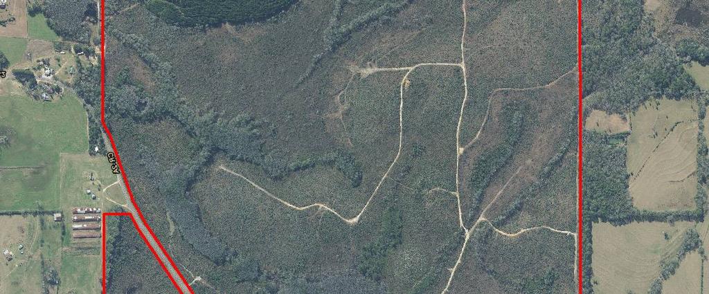
4 Aerial Map

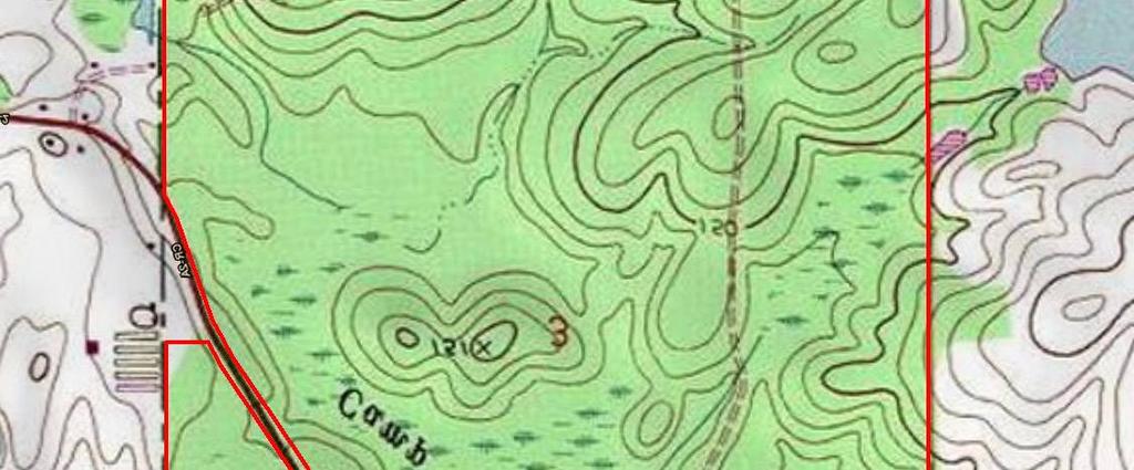
5 Top Map


6 Soils Map Color Key Soil Type Acres % of Area Drainage Class Ardilla Loamy Sand % Somewhat Poorly Drained Lucy Loamy Sand, 1 To 8 Percent Slopes % Well Drained Dothan Loamy Sand, To 5 Percent Slopes % Well Drained Bibb Association % Poorly Drained Dothan Loamy Sand, 5 To 8 Percent Slopes % Well Drained Dothan Complex % Well Drained Pantego Complex % Very Poorly Drained Stilson Loamy Sand, 1 To 3 Percent Slopes 16..6% Moderately Well Drained Fuquay Loamy Sand, 1 To 8 Percent Slopes % Well Drained Orangeburg Loamy Sand, To 5 Percent Slopes.0 0.3% Well Drained Orangeburg Loamy Sand, 5 To 8 Percent Slopes % Well Drained

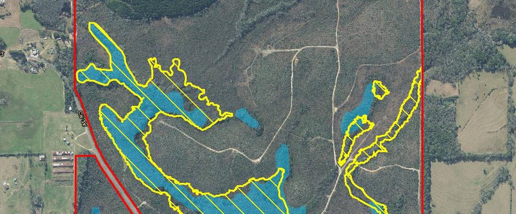
7 Wetland Map


8 Stand Map 3 1 Stand Acres Description PLB PLL CC NHW-Wet Total: 6.1


9 Photos
Land for Sale. Marion County, Georgia. $2,160,000 +/- 900 Acres $2,400 per Acre
 Land for Sale Marion County, Georgia 2 Contents Property Fact Sheet... 3 Regional Map... 4 Local Map... 5 Aerial Map... 6 Major Soil Types Map... 7 Soil Classification Map... 8 Soil Classification Table...
Land for Sale. Baker County, Georgia. $4,960,000 1,984 Acres $2,500 per Acre
 Land for Sale Baker County, Georgia $4,960,000 1,984 Acres $2,500 per Acre 2 Contents Property Fact Sheet... 3 Regional Map... 4 Local Map... 5 Aerial Map... 6 Major Soil Types Map... 7 Soil Classification
October 28, May 25, 2010
 October 28, 2009 May 25, 2010 Jim Farr Staff Director, Acquisition and Restoration Council Office of Environmental Services Division of State Lands Florida Department of Environmental Protection 3900 Commonwealth
Auction Location Eagles Club 316 S. 2 nd Street, Aberdeen, SD
 Auction Location Eagles Club 316 S. 2 nd Street, Aberdeen, SD Welcome We would like to invite and welcome you to our public auction! This is an excellent opportunity to add Brown County cropland to your
365.8 Acres +/- Brown County, KS February 28, 2019 at 10:30 am Community Building, 511 West Front Street, Fairview, KS
 Farmland Auction February 28, 2019 at 10:30 am Community Building, 511 West Front Street, Fairview, KS This excellent Brown County farm is just North of Fairview, KS and it will be selling in 3 tracts
CRESCENT GOLD 475± acres Putnam County, FL
 AGRIBUSINESS/RECREATION VALUE & APPEAL From an agricultural standpoint, this property offers 41 growing tunnels (in various sizes). These tunnels provide shade for growing beans, peppers, greens, tomatoes,
ROSE CREEK RANCH WINNEMUCCA, NV HUMBOLDT AND PERSHING COUNTY
 ROSE CREEK RANCH WINNEMUCCA, NV HUMBOLDT AND PERSHING COUNTY Industrial & Residential Development Site I-80 frontage @ Hwy 40 interchange Heart of Nevada Gold Country 2,743 acres Enjoy hunting, farming
173 ACRES - RILEY COUNTY, KS
 Buyers, Sellers & Land Connected PRICE: $690,000 ACRES: 173 COUNTY: RILEY STATE: KANSAS First Class Hunting with Outstanding Income Potential If you have ever dreamed of owning your very own piece of first
Soils and their Relationship with Agriculture
 Soils and their Relationship with Agriculture Presentation created by Thomas Gallagher Modified by Hank Bignell Capital Area Agriculture and Horticulture Program Cornell University Cooperative Extension
80 ACRES M/L BOONE COUNTY, IOWA LISTING # Pilot Mound, Iowa. I Avenue. 130th Street. Co Hwy P th Street
 Co Hwy P70 I Avenue 80 ACRES M/L BOONE COUNTY, IOWA CAPTION Pilot Mound, 130th Street 130th Street LISTING #12320 New Listing Price! $800,000 DESCRIPTION: High Quality Farm in Strong Farming Area and potential
Farmland For Sale 3 Tracts /- acres Webster County, Iowa Section 31, T88N, R30W & Section 33, T88N, R29W
 Farmland For Sale 3 Tracts 316.02 +/- acres Webster County, Section 31, T88N, R30W & Section 33, T88N, R29W Contact Martin today! 309-242-7299 mthornton@hbtbank.com Martin G. Thornton, Broker 200 W. College
FARMLAND AUCTION. FSA INFORMATION: Farmland: acres Cropland: acres Tillable: acres
 FARMLAND AUCTION January 22, 2019 at 10:30 am Keep an eye on BarnesRealty.com for possible blizzard date of 1/24/2019 Fisher Community Center, 201 E. Iowa St. Hiawatha, KS 66434 Here is a very productive
FOR SALE 280.5± ACRES SUSSEX COUNTY, VA Price: $430,000
 LATITUDE & LONGITUDE 37.5556, -79.2318 Winchester Front Royal 15 Leesburg 495 Washington 66 Chantilly Arlington Falls Church Fairfax Alexandria Springfield Manassas Warrenton 301 13 113 Dale City Waldorf
Land Sales Specialists Setting the trend for how Real Estate is sold in the Midwest.
 Land Sales Specialists Setting the trend for how Real Estate is sold in the Midwest. www.barnesrealty.com 18156 Hwy 59 Mound City, MO 64470 (660) 442-3177 1711 Oregon Hiawatha, KS 66434 (785) 742-4580
Custom Soil Resource Report Soil Map
 77 11' 22'' W Custom Soil Resource Report Soil Map 77 9' 43'' W 36 48' 13'' N 304700 304900 305100 305300 305500 305700 305900 306100 306300 306500 306700 306900 307100 36 48' 13'' N 36 47' 21'' N 4073800
TREASURE COAST REGIONAL PLANNING COUNCIL M E M O R A N D U M. To: Council Members AGENDA ITEM 5I
 TREASURE COAST REGIONAL PLANNING COUNCIL M E M O R A N D U M To: Council Members AGENDA ITEM 5I From: Date: Subject: Staff December 12, 2008 Council Meeting Local Government Comprehensive Plan Review Town
11: Good Design - Boor Site
 Rural Design Workbook: 11: Site Introduction: A dairy and feed farm of over 450 acres in the town of Horseheads (Chemung County), David Boor s property has a number of notable features. The site is nearly
PRIME RETAIL PROPERTY FOR SALE
 PRIME RETAIL PROPERTY FOR SALE 7000 Block Lima Road Fort Wayne, Indiana -Five Outlots Available -1.3 Acres to 9.1 Acres -High Traffic Counts: 39,000 + VPD -Nearby Retailers Include: Sam s Club, Lowe s,
131 ACRES M/L VAN BUREN COUNTY, IOWA LISTING #458 JIM KEDLEY. C: O:
 131 ACRES M/L VAN BUREN COUNTY, IOWA LISTING #458 JIM KEDLEY C: 563-212-5401 O: 563-659-8185 Jimkedley@totalrealtyco.com CWC Holdings LLC, 131 Acres M/L, Van Buren County, IA TOTAL ACRES: 131 MOL PRICE:
Team number Page 1 of Canon Envirothon Soils Station Test. Soils and Climate Change
 Team number Page 1 of 9 2006 Canon Envirothon Soils Station Test Soils and Climate Change There are many kinds of soil on the surface of the earth. The kind of soil that is present at a given location
South Commercial and Rural Fringe Land Use East Rural Fringe Land Use West - Planned Community (Pace Island)
") Revised 11/2/2015 Owners Name: Agent: G & H International Investments LLC 1890 Kingsley Avenue Suite 102 Orange Park, FL 32073 Susan L. Fraser, SLF Consulting, Inc. 3517 Park Street Jacksonville, FL 32205
Revised 11/2/2015 Owners Name: Agent: G & H International Investments LLC 1890 Kingsley Avenue Suite 102 Orange Park, FL 32073 Susan L. Fraser, SLF Consulting, Inc. 3517 Park Street Jacksonville, FL 32205
Appendix G Response to Comments
 Appendix G Response to Comments This appendix contains the comments received during the public circulation and comment period (May 27, 2008 to July 11, 2008). The comments have been numbered (Comment Set
Predicting Design Storm Runoff for the Six Mile Creek Watershed: Effects of the Potential Sprawl-Is-Us, Inc. Development
 Predicting Design Storm Runoff for the Six Mile Creek Watershed: Effects of the Potential Sprawl-Is-Us, Inc. Development Ross Guida Faulkner Consulting Engineers, Inc. December 19, 2008 1 Table of Contents
Gruene River Place PDD CONCEPT PLAN AND DEVELOPMENT STANDARDS
 Gruene River Place PDD CONCEPT PLAN AND DEVELOPMENT STANDARDS GRUENE RIVER PLACE PLANNED DEVELOPMENT DISTRICT As per Section 3.5, Chapter 144 of the City s Zoning Ordinance To: The Planning & Zoning Commission
2014 Iowa FFA Soil Judging CDE Exam
 2014 Iowa FFA Soil Judging CDE Exam 1. Landscape position is one aspect of evaluating the surface features of a certain tract of land. Identifying the correct landscape position will indicate: a. If the
TREASURE COAST REGIONAL PLANNING COUNCIL M E M O R A N D U M. February 19, 2010 Regional Planning Council Meeting
 TREASURE COAST REGIONAL PLANNING COUNCIL M E M O R A N D U M To: Council Members AGENDA ITEM 5H From: Date: Subject: Staff February 19, 2010 Regional Planning Council Meeting Local Government Comprehensive
LAND FOR SALE. Beautiful Farmstead. Pifer s. Price: $1,250, /- Acres Green County, WI
 Beautiful Farmstead LAND FOR SALE 176 +/- Acres Green County, WI Price: $1,250,000 Auction & Realty - Robert Scott Pifer, Broker (#56685-90) RE Entity License #937110-91, Auction Company License #429-53
Sacramento River Farmland Anderson, California
 AG-LAND INVESTMENT BROKERS 275 Sale Lane / P. O. Box 896 Red Bluff, CA 96080 530.529.4400 office / 530.527.5042 fax Sacramento River Farmland Anderson, California Property: 43 +/- acres of farmland with
2.1 Principles & Objectives
 Designing With The Landform 2.1 Principles & Objectives Land planning which integrates the natural features of a site (i.e., designing with the landform ) into the site design is a major component of the
Blueberry Farm Sumter County 46 +/- Acres Webster, FL Turnkey Operation!
 Blueberry Farm Sumter County 46 +/- Acres Webster, FL Turnkey Operation! Highly Productive Blueberry Farm 9 Varieties of Blueberries! GPS Coordinates: 28 degrees 33 min 01.32 sec North / 82 degrees 04
THE PLANNING AREA 2.1 PLANNING AREA LOCATION
 2. The Planning Area Brisbane Baylands Specific Plan 21 2 THE PLANNING AREA 2.1 PLANNING AREA LOCATION The Baylands is located approximately midway between San Francisco s central business district and
LAND FOR SALE 82 ACRES M/L CEDAR COUNTY, IOWA LISTING # DOUGLAS R. YEGGE C: O:
 LAND FOR SALE LISTING #13968 82 ACRES M/L CEDAR COUNTY, IOWA DOUGLAS R. YEGGE C: 563-320-9900 O: 563-659-8185 Doug@PeoplesCompany.com ALAN MCNEIL C: 563-321-1125 O: 563-659-8185 Alan@PeoplesCompany.com
FOR SALE NEW PRICE HILL FAMILY FARM WATKINS CORNER, AR. Phillips County, Arkansas: 2,300+/- Acre Irrigated Grain Farm NEW PRICE/YIELD UPDATES:
 NEW PRICE FARMLAND ADVISORS FOR SALE HILL FAMILY FARM WATKINS CORNER, AR 2,300+/- Acres - Phillips County, Arkansas $10,950,000 Phillips County, Arkansas: 2,300+/- Acre Irrigated Grain Farm NEW PRICE/YIELD
Yields of Non-Irrigated Crops (Component): Soybeans (Bu) Edgecombe County, North Carolina, and Halifax... (SOYBEANS)
: Soybeans (Bu) Edgecombe County, North Carolina, and Halifax... (SOYBEANS)") 77 37' 52'' W Yields of Non-Irrigated Crops (Component): Soybeans (Bu) Edgecombe County, North Carolina, and Halifax... () 77 36' 28'' W 263300 263600 263900 264200 264500 264800 265100 36 6' 59'' N 36
77 37' 52'' W Yields of Non-Irrigated Crops (Component): Soybeans (Bu) Edgecombe County, North Carolina, and Halifax... () 77 36' 28'' W 263300 263600 263900 264200 264500 264800 265100 36 6' 59'' N 36
Unit II Soil Management
 Unit II Soil Management Lesson 2: Using Soil Survey Manuals Soil survey manuals provide useful information for grassland management. Soil scientists evaluate the soil for chemical and physical properties,
FARMLAND FOR SALE ± Acres 5 Tracts
 Now is your chance to acquire productive farmland in Greene County, Illinois. Greene County, IL FARMLAND FOR SALE 756.08± Acres 5 Tracts Highly productive riverbottom farms Heavily improved with tiling
Gadsden County Planning Commission Agenda Request
 Date of Meeting: November 16, 2017 To: From: Through: Subject: Gadsden County Planning Commission Agenda Request Honorable Chairperson and Members of the Board Jill A. Jeglie, AICP, Senior Planner Clyde
LAND AUCTION. Open House: Saturday, August 6th and Saturday, August 20th From 9:00 AM to 11:00 AM at 1220 C Avenue, Scranton, Iowa
 L-1005 LAND AUCTION 1,235+/- Acres, Carroll and Greene Counties, Iowa Friday, August 2, 201 10:00 AM at the Saint Joseph s Parish Center 501 North Locust Street Jefferson, Iowa Highlight Features: Over
Plum Run Family Farms. This Land is Your Land
 Plum Run Family Farms This Land is Your Land A nice happy peaceful place r0n the country On some of the most scenic and fertile farmland at Plum Run, a limited number of 3-acre plots of land have been
University of Florida Conservation Area Land Management Plan Solar Park Pond
 University of Florida Conservation Area Land Management Plan Solar Park Pond Introduction Solar Park Pond is an approximately 10.6-acre Conservation Area located on both sides of SW 23 rd Terrace, adjacent
2016 Iowa FFA Soils Evaluation CDE Exam
 2016 Iowa FFA Soils Evaluation CDE Exam 1. Which of the following is true regarding soil horizons? a. A horizon is darker in color and has more organic matter b. B horizon is darker in color and has more
1.0 Circulation Element
 5/9/18 1.0 Circulation Element 1.1 Introduction As growth and development occur in Apache County, enhancements to its circulation system will be necessary. With time, more roads will be paved and air and
BLOOMSBURY BOROUGH. Regional Master Plan Overlay Zone Designation. 1 inch = 0.28 miles. Zone. Sub-Zone FRANKLIN TOWNSHIP GREENWICH TOWNSHIP
 Regional Master Plan Overlay Zone Designation Zone Protection Lakes Greater Than 10 acres Conservation Existing Community Sub-Zone Existing Community Environmentally Constrained Conservation Environmentally
Pits 1 & 3 Questions. 7. Subsurface: Texture (5 pts) A. Coarse B. Moderately course C. Medium D. Fine E. Very Fine
 A. Coarse B. Moderately course C. Medium D. Fine E. Very Fine") Minnesota Soils Scorecard Questions for Pits 1-4 Scantron # 105481 Use your soils scorecard to fill out the answers on your scantron Bubble in the front side of the sheet for Pit 1 (# 1-45) and Pit 2 (#51-95)
Minnesota Soils Scorecard Questions for Pits 1-4 Scantron # 105481 Use your soils scorecard to fill out the answers on your scantron Bubble in the front side of the sheet for Pit 1 (# 1-45) and Pit 2 (#51-95)
III. PROJECT DESCRIPTION
 III. PROJECT DESCRIPTION A. PROJECT LOCATION Regional Setting The project site is located in the southeast quadrant of the City of Chico in Butte County, California and is comprised of four parcels totaling
LAND FOR SALE 314 ACRES M/L BERG, WORTH COUNTY, IOWA LISTING # DOUGLAS R. YEGGE C: O:
 LAND FOR SALE LISTING #13870 314 ACRES M/L BERG, WORTH COUNTY, IOWA DOUGLAS R. YEGGE C: 563-320-9900 O: 563-659-8185 Doug@PeoplesCompany.com ALAN MCNEIL C: 563-321-1125 O: 563-659-8185 Alan@PeoplesCompany.com
The Next Great Growth. The Next Great Growth Region of Florida. Infrastructure and Other Improvements. A Presentation Delineating the Major
 The Next Great Growth The Next Great Growth Region of Florida A Presentation Delineating the Major Infrastructure and Other Improvements in Central Northwest Florida Why Here? Why Now? Why Here? Why Now?!
EXHIBIT 5-1 VILLAGE OF WILD ROSE FUNCTIONAL CLASS AND AVERAGE DAILY TRAFFIC VOLUMES 2000 & 2003 DATA
 3400 3600 EXHIBIT 5-1 FUNCTIONAL CLASS AND AVERAGE DAILY TRAFFIC VOLUMES 2000 & 2003 DATA Rural Minor Arterial Rural Major Collector Rural Minor Collector Rural Local 2000 Traffic Count 2003 Traffic Count
Mitchell Ranch South MPUD Application for Master Planned Unit Development Approval Project Narrative. Introduction
 Mitchell Ranch South MPUD Application for Master Planned Unit Development Approval Project Narrative Introduction Mitchell Ranch South is a proposed single family (detached) residential development on
Preserving Green Streetscape Character on Hillside Drive
 STAFF REPORT ACTION REQUIRED Preserving Green Streetscape Character on Hillside Drive Date: February 19, 2014 To: From: Toronto and East York Community Council Deputy City Manager, Cluster B Wards: Toronto-Danforth,
Annual lease of the tillable acreage for crops (soybeans and/or corn).
.") FOR SALE $895,000.00 11201 Hill Road, Woodsboro, Maryland 21798 Crop Farm with Subdivision Potential PRESENTING Location: 11201 Hill Road, Woodsboro, MD 132.2064 acre crop farm with extraordinary views,
FOR SALE $895,000.00 11201 Hill Road, Woodsboro, Maryland 21798 Crop Farm with Subdivision Potential PRESENTING Location: 11201 Hill Road, Woodsboro, MD 132.2064 acre crop farm with extraordinary views,
Sam Houston Ranger District West/Central WUI Fuels Reduction Project Soil and Water Resources
 Soil and Water Resources The Sam Houston National Forest has identified specific wildland urban interface (WUI) areas within Compartments 33, 36, 37, 49, 57, and 66 that contain high fuel loadings. This
280 ACRES - HOWELL COUNTY, MO
 PRICE: $434,700 ACRES: 280 COUNTY: HOWELL STATE: MISSOURI For more information contact: KYLE ORF, Land Agent 417.988.3333 KyleOrf@MidwestLandGroup.com MidwestLandGroup.com 100 280ACRES ACRES- -COUNTY,
Boardman River Watershed VILLAGE OF KALKASKA. WATER QUALITY ACTION PLAN Fall 2009
 Boardman River Watershed VILLAGE OF KALKASKA WATER QUALITY ACTION PLAN Fall 2009 Partners: The Watershed Center Grand Traverse Bay Northwestern Michigan College - Great Lakes Water Studies Institute Grand
Friendly Persuasion Farm
 Friendly Persuasion Farm 1061 White Pine Flats Troy, Idaho $975,000 Overview Specifically designed as a pilot and horse-lover s dream, this 173 +/- acre property is a gem in Northern Idaho. Features include
Land Capability Classifications
 Land Capability Classifications Unit: Soil Science Problem Area: Basic Principles of Soil Science Student Learning Objectives. Instruction in this lesson should result in students achieving the following
80 ACRES M/L CEDAR COUNTY, IA LISTING #465 DOUGLAS R. YEGGE ALAN MCNEIL. C: O:
 80 ACRES M/L CEDAR COUNTY, IA LISTING #465 DOUGLAS R. YEGGE C: 563-320-9900 O: 563-659-8185 total@totalrealtyco.com ALAN MCNEIL C: 563-321-1125 O: 563-659-8185 alan@totalrealtyco.com Kroemer, 80 Acres
TOWN OF SPRINGFIELD, NEW HAMPSHIRE
 TOWN OF SPRINGFIELD, NEW HAMPSHIRE NATURAL RESOURCES INVENTORY EXECUTIVE SUMMARY March 2008 Prepared by: Watershed to Wildlife, Inc. Natural Resource Consultants 42 Mill Street, Suite 3 Littleton, NH 03561
FOR SALE HILL FAMILY FARM WATKINS CORNER, AR. Phillips County, Arkansas: 2,300+/- Acre Irrigated Grain Farm NEW PRICE/YIELD UPDATES:
 SOLD FARMLAND ADVISORS FOR SALE HILL FAMILY FARM WATKINS CORNER, AR 2,300+/- Acres - Phillips County, Arkansas $10,950,000 Phillips County, Arkansas: 2,300+/- Acre Irrigated Grain Farm NEW PRICE/YIELD
3.10 LAND USE SETTING PROJECT SITE EXISTING LAND USE DESIGNATIONS AND ZONING. General Plan Land Use Designations.
 This section of the Draft EIR addresses the existing land uses on and adjacent to the project site and discusses the potential impacts of the proposed project on existing land uses. Key issues addressed
268 Acres m/l, Iowa County, IA. Offered in 2 Remaining Parcels. Parcel Ac. m/l Parcel 2-81 Ac. m/l Parcel 3-45 Ac. m/l - SOLD!
 LAND FOR SALE 268 Acres m/l, Iowa County, IA Offered in 2 Remaining Parcels Parcel 1-187 Ac. m/l Parcel 2-81 Ac. m/l Parcel 3-45 Ac. m/l - SOLD! Golden Grain Enterprises Good Iowa County Farms Located
SUMMARY. Support the Southeast Arkansas Regional Intermodal Facility.
 SUMMARY THE I-69 LOCATION STUDY The proposed I-69 Location Study from El Dorado to McGehee, Arkansas, represents one section (Section of Independent Utility No. 13) of the nationally designated I-69 Corridor
Open Space and Farmland Preservation
 Vibrant. Green. Connected. Competitive. Open Space and Farmland Preservation Statement of Purpose The purpose of this section of the Plan is to encourage and support the preservation of open space areas
IV. Development in the Rural Overlay District
 Intracoastal Waterway Route 17 Route 168 Great Dismal Swamp VIRGINIA NORTH CAROLINA IV. Development in the Rural Overlay District IV-1 Route 17 in Chesapeake s Rural Overlay District affords distant views
RURAL AREA. It s Our Future
 RURAL AREA www.ourfuturevb.com It s Our Future RURAL AREA STRATEGY... MEANS Preserving Rural Heritage Ensuring Viable Agriculture Protecting Natural Resources Enable Rural Growth RURAL AREA Description
Table of Contents INTRODUCTION APPLICATION. Document No.: WRG 5A-8 Publication Date: 10/4/2012
 MINNESOTA WETLAND RESTORATION GUIDE PLANTING UPLAND TREES AND SHRUBS TECHNICAL GUIDANCE DOCUMENT Document No.: WRG 5A-8 Publication Date: 10/4/2012 Table of Contents Introduction Application Other Considerations
Target area around Baltoji Ančia herpetological reserve LT07
 Target area around Baltoji Ančia herpetological reserve LT07 Description of the area Baltoji Ančia Herpetological Reserve Varviškė The areas are on the very border of Belorussia, on the coast of river
2012 FINAL SOILS AREA 2 Envirothon Questions Answer KEY
 2012 FINAL SOILS AREA 2 Envirothon Questions Answer KEY Questions 1-6 to be answered at the soil pit: 1. Soil scientists categorize soils by drainage classes. What is the drainage class of the soil at
Custom Soil Resource Report for Craighead County, Arkansas
 United States Department of Agriculture Natural Resources Conservation Service A product of the National Cooperative Soil Survey, a joint effort of the United States Department of Agriculture and other
Marshview Park. Concept Briefing and Feedback Session. Aquarium/Owls Creek Plan Steering Committee March 20, 2012
 Marshview Park Concept Briefing and Feedback Session Aquarium/Owls Creek Plan Steering Committee March 20, 2012 1 Outline of Today s Discussion Introductions Context for Marshview Park Site analysis -
Rural Land Use Designations Kittitas County December 6, 2007 Draft
 KITTITAS COUNTY COMMUNITY DEVELOPMENT SERVICES 411 N. Ruby St., Suite 2, Ellensburg, WA 98926 CDS@CO.KITTITAS.WA.US Office (509) 962-7506 Fax (509) 962-7682 Rural Land Use Designations Kittitas County
MEMORANDUM AGENDA ITEM #6c
 South Florida Regional Planning Council MEMORANDUM AGENDA ITEM #6c DATE: FEBRUARY 1, 2010 TO: FROM: SUBJECT: COUNCIL MEMBERS STAFF CITY OF PARKLAND PROPOSED COMPREHENSIVE PLAN AMENDMENT (ALTERNATIVE REVIEW)
WALKER FEEDLOT Total taxable acres, part fenced. 4 homes & multiple nice/modern outbldgs hd feedyard with sprinklers a-shkd-0002
 ABILENE WALKER FEEDLOT 38.7 Total taxable acres, part fenced 4 homes & multiple nice/modern outbldgs 3500 hd feedyard with sprinklers a-shkd-0002 Center pivot irrigation from lagoons 999 hd feedlot A-SHDK-B020
Linden Homes Proposals for land east of Glebe Farm, Sawtry
 Welcome Welcome to Linden Homes public exhibition displaying emerging proposals for the development of land east of Glebe Farm, Sawtry. Linden Homes has an interest in this land and is currently preparing
Level 1: GIS-based Desktop Assessments. Meghan Burns, Landscape Ecologist
 Level 1: GIS-based Desktop Assessments Meghan Burns, Landscape Ecologist EPA three-tier framework WETLAND AND RIPARIAN MAPPING LEVEL 1 LANDSCAPE ASSESSMENT WETLAND LANDSCAPE PROFILES LEVEL 2 RAPID ASSESSMENT
Key Elements of Successful Conservation Planning. John Paskus October 17, 2013 Pierce Cedar Creek Institute Michigan Natural Features Inventory
 Key Elements of Successful Conservation Planning John Paskus October 17, 2013 Pierce Cedar Creek Institute Michigan Natural Features Inventory What is Conservation Planning? Pressey et al (2008): The process
JULIAN HOME SITE PROPERTY REPORT
 ADDRESS: HWY 79, Julian, CA 92036 JULIAN HOME SITE PROPERTY REPORT DESCRIPTION: A rare 3.37+/- acre home site in the Kentwood area of Julian. This site is contiguous with Highway 79, but accessed via Lakeview
DRAFT SCOPE OF SERVICES PEER REVIEW OF BAKER PARK. Request for Qualifications (RFQ)
") DRAFT SCOPE OF SERVICES PEER REVIEW OF BAKER PARK Request for Qualifications (RFQ) The following scope of services is presented for consideration and development of firm qualifications submittal. Some
DRAFT SCOPE OF SERVICES PEER REVIEW OF BAKER PARK Request for Qualifications (RFQ) The following scope of services is presented for consideration and development of firm qualifications submittal. Some
The analysis area for the scenic resource is the project area described in Chapter 1. Affected Environment/Existing Condition
 Chapter 3 - Scenic Resource SCENIC RESOURCES Introduction The Spotted Bear Ranger District is a destination point for outdoor recreation activities and offers a variety of recreation opportunities: driving
2 Project Description
 Project Description 2 Project Description The proposed project would involve the demolition of the existing church and the construction of 40 twostory single family residences. The residential lots would
Everett Prune Farm Glenn County, California
 Everett Prune Farm Glenn County, California Proudly Offered By 707 Merchant Street, Suite 100, Vacaville, Ca 95688 (707) 455-4444 Office (707) 455-0455 Fax info@caoutdoorproperties.com www.californiaoutdoorproperties.com
RACER Properties in Pontiac
 RACER Properties in Pontiac Bruce Rasher, Redevelopment Manager brasher@racertrust.org Pontiac, MI Fiero Assembly Plant Pontiac North Campus Industrial Land Fiero Powerhouse 2017 Google Pontiac North Campus
Bridgedale, Bridgetown Request for Expressions of Interest to Lease and/ or Develop
 Bridgedale, Bridgetown Request for Expressions of Interest to Lease and/ or Develop 1 Are you interested in leasing Bridgetown s oldest building and/or redeveloping an iconic site on the banks of the Blackwood
September 20, 2016 Soils Investigation for Agricultural Designation Windemere Place, Missoula County, Montana
 September 20, 201 Soils Investigation for Agricultural Designation Windemere Place, Missoula County, Montana The purpose of this report is to compare on-site soils of the proposed subdivision with the
Exhibit A. 8:9 Scuffletown Rural Conservation District
 Exhibit A 8:9 Scuffletown Rural Conservation District 8:9.1 Intent and Purpose The Scuffletown Rural Conservation (SRC) District is intended to provide for residential development that supports the development
Florida Forever Conservation Needs Assessment Overview Maps
 Florida Forever Conservation Needs Assessment Overview Maps Prepared by Florida Natural Areas Inventory, The maps in this document are derived from the Florida Forever Conservation Needs Assessment, an
+/- 60 AC LAND FOR SALE HARLEY ROAD, ELBURN, IL 60119
 Land For Sale OFFERING SUMMARY Sale Price: $660,000 Price / Acre: $11,000 PROPERTY OVERVIEW +/- 60 acres available for purchase on the west side of Harley Road, South of Rt. 38. This site has Harley Road
Soil Science Society of America. is important to South Carolina. What is Lynchburg Soil?
 Lynchburg South Carolina State Soil Soil Science Society of America Introduction Many states have a designated state bird, flower, fish, tree, rock, etc. And, many states also have a state soil one that
Zoning Docket from April 16, 2018 Public Hearing CC DIST. STAFF REC. 21 Approval
 Zoning Docket from April 16, 2018 Public Hearing Docket Number CZ-2018-30 Public Comments Staff Report Applicant Matthew Clayton Driggers for Smith Road Investments and Thomas P. Hartness Revocable Trust
Town of Rico Three Mile Plan for Annexation
 Town of Rico Three Mile Plan for Annexation 10.20.2010 Adopted by Resolution 2010-2 Produced with funding support from the Colorado Department of Local Affairs 2 Content Guide Introduction. 3 Annexation
Demoss Farm & Home 118 Acres, M/L W. 209th Ave. Pattonsburg, Mo 64670
 118 Acres, M/L 39436 W. 209th Ave. Pattonsburg, Mo 64670 PRICE: $400,000.00 LAND USE: FSA shows approx. 118.32 farmland acres, ml, of which there were 36.47 acres of effective cropland with the remainder
LAND FOR SALE 30 ACRES M/L FLOYD COUNTY, IOWA LISTING # DOUGLAS R. YEGGE C: O:
 LAND FOR SALE LISTING #13886 30 ACRES M/L FLOYD COUNTY, IOWA DOUGLAS R. YEGGE C: 563-320-9900 O: 563-659-8185 Doug@PeoplesCompany.com ALAN MCNEIL C: 563-321-1125 O: 563-659-8185 Alan@PeoplesCompany.com
M E M O R A N D U M July 27, 2018
 M E M O R A N D U M July 27, 2018 To: Southlake 2035 Corridor Planning Committee From: Kenneth Baker, Sr. Director of Planning and Development Services Subject: Item #6 First National Bank Purpose Review,
NEW CASTLE COUNTY S ZONING DISTRICTS
 NEW CASTLE COUNTY S ZONING DISTRICTS This is general information about New Castle County s zoning districts. The information included is by no means exhaustive or complete. Before designing plans to develop
PLANNED UNIT DEVELOPMENT PUD For The Proposed Antietam Subdivision Escambia County, Florida. Introduction
 PLANNED UNIT DEVELOPMENT PUD For The Proposed Antietam Subdivision Escambia County, Florida Introduction The project is located in Escambia County approximately 0.75 + miles north of the US Highway 90,
NORTH BETHANY ELEMENTARY SCHOOL SITE ASSESSMENT
 NORTH BETHANY ELEMENTARY SCHOOL SITE ASSESSMENT Prepared for: Prepared by: October 10, 2014 Page 2 Introduction and Purpose This report provides an assessment of two potential sites for a new elementary
Ancient Greek and Roman planners recognized the importance of centralized gathering spaces within urban
 TEAMS Competition 2014 Urban Green Space Design Introduction Ancient Greek and Roman planners recognized the importance of centralized gathering spaces within urban areas. Early Greek agora and Roman forums
Silverwood Masterplan Kickoff Meeting. Jim Neidhart Dane County Parks Planning
 Silverwood Masterplan Kickoff Meeting Jim Neidhart Dane County Parks Planning 608-224-3614 January 30, 2014 Silverwood County Park Public Information Meeting Notice Sent notice to all landowners adjacent
DRAFT SECTION 4(f) EVALUATION INTERSTATE 73 FEIS: I-95 to I-73/I-74 in North Carolina
 EVALUATION INTERSTATE 73 FEIS: I-95 to I-73/I-74 in North Carolina") DRAFT SECTION 4(f) EVALUATION INTERSTATE 73 FEIS: I-95 to I-73/I-74 in North Carolina 1.0 INTRODUCTION Section 4(f) of the Department of Transportation Act of 1966, 49 U.S.C. 303, requires that prior to
DRAFT SECTION 4(f) EVALUATION INTERSTATE 73 FEIS: I-95 to I-73/I-74 in North Carolina 1.0 INTRODUCTION Section 4(f) of the Department of Transportation Act of 1966, 49 U.S.C. 303, requires that prior to
3. What are the five master horizons? Give distinguishing features of each. 5. List three means by which plant roots come into contact with nutrients.
 Study Questions Exam 1 1. What are the four general components of soil? 2. Define regolith and solum. 3. What are the five master horizons? Give distinguishing features of each. 4. What is meant by an