RURAL AREA. It s Our Future
|
|
|
- Derick Cobb
- 5 years ago
- Views:
Transcription

1 RURAL AREA It s Our Future


2 RURAL AREA STRATEGY... MEANS Preserving Rural Heritage Ensuring Viable Agriculture Protecting Natural Resources Enable Rural Growth RURAL AREA Description The vision of the has not changed much over time. From providing a legacy for a future generation of farmers, to providing habitat for wildlife, keeping taxes low, assuring continued local food production, and maintaining the rural community, the vision for our rural landscape is important. The physical character of this area is low, flat land with wide floodplains and altered drainage. It is a place that still contains working farms, farm related businesses, limited non-residential areas along with some scattered housing sites. There is a significant presence of existing agricultural and other rural-based economic activities in this part of Virginia Beach. This presence is reflected in the diversity of agricultural and rural related activities including traditional and specialty crop cultivation, tree farms, equestrian facilities, wetland banks, fish farms and other similar uses. There are a few, small commercially zoned nodes that provide basic support retail and services to local rural community. Most notable of these is Pungo, a rural community gateway located at the intersection of Indian River and Princess Anne Roads that serves as the principal gateway to the southern rural area. The lies south of Indian River Road from North Landing Road to Muddy Creek and Back Bay and extends to the North Carolina border. The land, wetland and water cover nearly 145 square miles, close to half of the total area of the City. Approximately 28,000 acres, or nearly 44 square miles, of land is devoted to production agriculture, upland forest and pasture. Wetland and water cover about 48,700 acres and an additional 9,700 acres is either privately owned or federal and state owned property used for environmental conservation purposes. Only about 3,200 acres of land in this area is actually developed, comprised mostly of rural dwellings and a small amount of rural commercial uses. Most of the area is comprised of Land Management soils. These are somewhat Poorly, Poorly or Very Poorly drained soils, as Small Working Farm 5-1


3 defined in the 1985 issue of the U.S. Soil Survey for Virginia Beach, and are not suitable for large subdivisions. It would be highly impractical to extend public water and sewer lines to this area. Given these factors, it is logical to conclude that the will remain rural into the foreseeable future and, as such, it must rely on sound rural planning principles and effective economic strategies to help it retain its character and vitality. Large Working Farm acres in 1982 to roughly 32,000 acres in In order to stop or reverse this downward trend, effective and affirmative agricultural preservation strategies must be put into place. Agricultural preservation is an important economic and land use issue. Hence, it is important for comprehensive planning strategies to do their part in reinforcing and promoting agriculture as much as possible. One implementation tool Virginia Beach has been using with much success is the Agricultural Reserve Program. RURAL PRESERVATION PLAN It is the purpose of this Rural Preservation Plan to identify appropriate, fair and equitable rural planning policies for our. The City seeks to achieve the following five planning objectives: 1. Preserve and Promote the Opportunity for Continued Agricultural Production One of the key objectives of the Rural Preservation Plan is to provide opportunities for preserving agriculture. Our City s agricultural land (cropland, pasture, forest), both north and south of the Green Line, has dwindled from about 51,000 Rural Character and Scenic Beauty 2. Recognize the Rural Character and the Need to Preserve its Open Space and Scenic Beauty The City of Virginia Beach wants to preserve the rural way of life for the people who live there, but how can we accommodate the demand for a rural lifestyle without diminishing the rural setting in the process? Many people who live in rural areas expect to continue the rural lifestyle enjoyed by previous generations. Rural areas may be characterized as a balance between the natural environment and human uses with farms, horse boarding, campgrounds, wineries, and open space activities served by long stretches of two lane roadways. The presence and growth of equestrian-related uses complement the rural way of life and contribute to the diversity and 5-2

4 economic health of the City. There are occasional commercial nodes like Back Bay and Creeds that are small in scale with a few houses next to some shops serving, in a limited way, the commercial needs of a rather large geographic area. Industrial uses will generally be those that are related to and dependent on natural resources such as agriculture, timber or minerals. One way to protect the rural setting is to protect the historic resources in the. Accordingly, it is the City s policy to use all available resources including those provided by the City s Historic Review Board and Historic Preservation Commission as well as the Princess Anne County /Virginia Beach Historical Society to preserve designated historic resources. Efforts to retain these historic resources should be accomplished in a responsible and innovative manner. The efforts include providing land use planning guidance and tax credit assistance to owners of historic properties in order to help protect and preserve the City s limited number of valuable historic resources and surrounding open space areas. Owners of qualified properties should be encouraged to participate in the Virginia Beach Historical Register program and receive recognition for their contributions to our City s heritage. 3. Protect and Sustain Environmental Resources for Future Generations Well over half of the total area south of Indian River Road is comprised of water and tidal and nontidal wetlands. Much of it is located in low-lying floodplain zones, publicly owned environmental conservation areas, and areas consisting of poorly drained soils. These so called Land Management Soils are capable of handling only a very limited amount of new development. It is an important comprehensive planning objective to protect and sustain all our valuable environmental, scenic and agricultural resources against inappropriate activities and intense Munden Point Park growth pressures. We must orient rural residential development away from sensitive environmental resources to areas consisting of well-drained soils and deeper water tables that are capable of handling septic systems. This, coupled with the objective of maintaining a reasonable overall level of rural development potential, establishes sound planning policy that balances the need for limited rural growth against its impact on the surrounding natural environmental. Because of the unique topography in this area, no new residential dwelling units shall be located within the floodplains as cited in Section 5B of the City s Site Plan Ordinance. 4. Provide Reasonable Rural Development Opportunities This Rural Preservation Plan affords reasonable rural development opportunities well beyond the 10 or 20-year horizon. Property owners may choose to sell their development rights by participating in the Agricultural Reserve Program or to develop their land either by-right, which yields a minimum density, or through a conditional use approach which may yield a higher rural density while preserving large tracts of farmland and open space areas. Rural development 5-3

5 potential is based on land area and soil quality as opposed to lot frontage. The design of a new development is a key component to minimizing impacts to or loss of rural character. Growth should be guided towards the more traditional rural center. 5. Eliminate Need for Urban Infrastructure It has been a long-standing policy of the City not to allow the extension of urban infrastructure into the rural area of the City and this policy remains in effect. The Rural Preservation Plan allows reasonable levels of rural residential development to continue into the foreseeable future thus ensuring that demand placed on public facilities will remain at or below what is deemed acceptable for rural communities. For example, over the past few decades, the rate of development in this area has held steady at around 30 to 40 dwelling units per year. The City also recognizes its responsibility to provide programmed improvements and ongoing public facility and infrastructure maintenance projects in this area. Pungo Description The most recognizable gateway to the southern rural area is Pungo. It comprises a small and varied cluster of commercial, residential and public properties located around the crossroads of Indian River and Princess Anne Roads. Both roads serve as major access routes into this region. The northern two quadrants of Pungo lie in the Transition Area where limited suburban growth is recommended and the southern quadrants are located Pungo Gateway in an area designated for rural use. The area south of Pungo consists of farmland, equestrian centers, small rural commercial centers, estate homes, rural residential neighborhoods and conservation areas. The area north of Pungo is characterized by large, suburban residential developments that are still under construction, patches of farmland and a 130-acre regional commercial center. Recommendations A community-based Pungo Center Implementation Plan should be undertaken to guide the creation of a vibrant village center, one that respects the rural integrity and heritage of the area. The Plan should include a process of developing an Implementation Plan with a coordinated effort to create a zoning overlay and design guidelines that will incentivize and enforce land use recommendations. The plan should include the following elements:»» Land Use»» Transportation»» Environment»» Infrastructure»» Other Public Service Delivery»» Economic Vitality»» Housing and Neighborhoods»» Design and Heritage»» Community Involvement 5-4
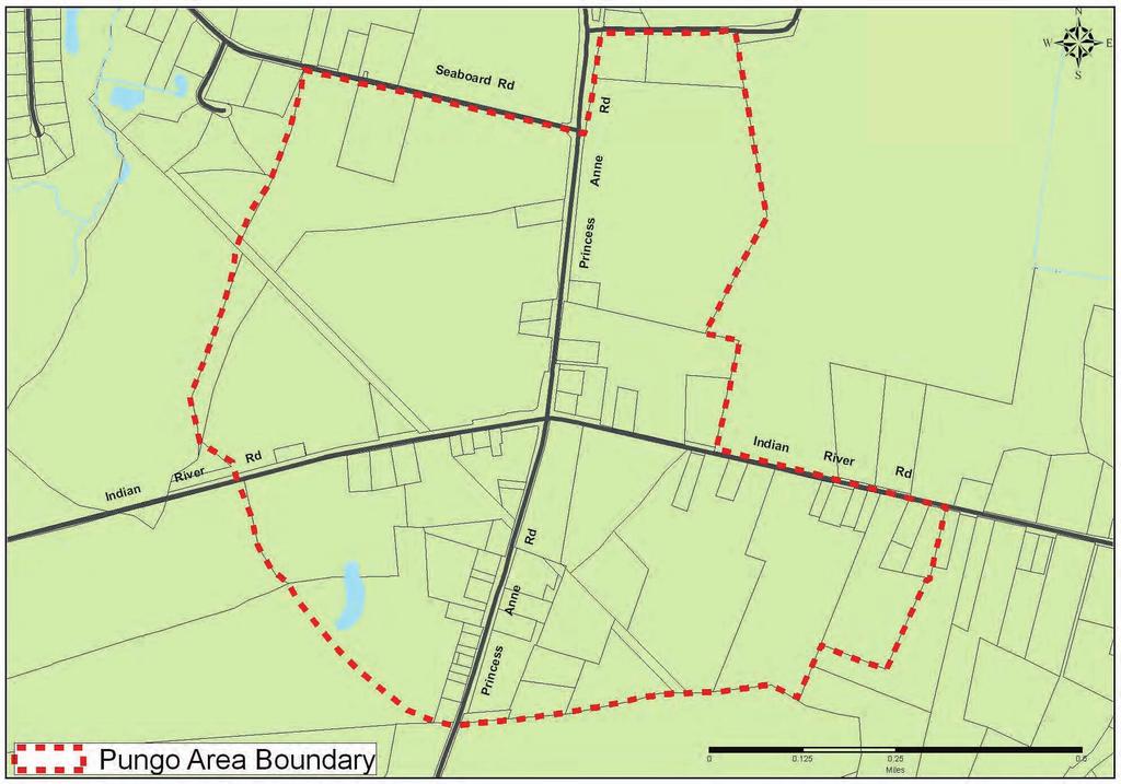
6 PUNGO 5-5
7 Recommendations»» Cost Estimates»» Implementation Tools»» Branding and Marketing Interim Planning Guidelines for Pungo Until the implementation plan is adopted, the following interim planning guidelines should be applied to development or redevelopment proposals within the Pungo area.»» Development proposals should reflect the rural character of existing historic structures.»» Refurbish and preserve older historic structures (i.e Pungo Grill, Munden s Store).»» Avoid further suburbanization (i.e. large, separate and single uses with parking in front).»» Avoid discretionary action that would further a suburban pattern of development.»» Plan and design a special character for Pungo Center that respects its rural heritage and incorporates the general Site and Design Principles as cited in the Comprehensive Plan s Reference Handbook.»» Protect existing public rights of way and provide additional pavement width on Princess Anne and Indian River Roads in Pungo to accommodate safer movement of farm equipment and bicyclists.»» Improve traffic signalization and optimize dedicated turn lights and associated left turn lanes for the predominant turning movements during peak traffic periods.»» Consolidate scattered accesses to property into clearly defined entrances off the road.»» Provide a safe, attractive and continuous pedestrian network.»» Public water and sewer is recommended to serve the area north of Indian River Road with an alternative centralized sewer system serving the area south of this road. General Land Use Recommendations for Pungo Development proposals that affect properties in the Pungo Area prior to adoption of the implementation plan should consider the following general land use recommendations for each quadrant located around the Princess Anne and Indian River Road intersection. A fiscal feasibility assessment must be conducted prior to programming any public facilities within this study area.»» Northwest Quadrant The property facing the intersection should accommodate primarily service and retail uses, and the buildings and structures should attempt to re-create a village street facade similar to that of older villages. Parking should be located behind the buildings. The quadrant is an appropriate location for an inn, which could act as a distinct centerpiece, differentiating this quadrant from the others by projecting a unique site and architectural connection with Pungo Center. An inn would offer food, lodging, and resort-style services such as spa facilities, horseback riding, and elder hostel activities. It could act as an appropriate interface with the equestrian and agricultural uses in the northern and western extremities of the quadrant. 5-6

8 »»»» Northeast Quadrant The preservation of small-scale retail and commercial uses at the intersection and the creation of a heritage park of about 15 acres incorporating a public market are recommended for this quadrant. The park would be an outdoor repository of historical structures and a place for seasonal activities. This quadrant is also ideal for an outdoor arena and livestock or horse exhibition area of about 45 acres. The creation of a woodland preserve is also recommended to create a visual statement at the entrance to the outdoor arena area. Southeast Quadrant Locate a mix of civic, commercial, residential, and open space uses, providing a diversity of development opportunities. Revitalization of existing housing and shops should be accomplished to achieve consistency with older historic structures. For example, plans should integrate a renovated Munden s store as an important historic cornerstone. Appropriate sidewalk, trail, and pedestrian facilities are recommended to allow movement between Munden s, the adjacent vacant parcels, and the commercial core on either side of Princess Anne Road to the south. The City will need to determine the appropriate additional rights-of-way or easements necessary to accommodate these pedestrian facilities. The City should initiate and undertake these activities with cooperation from property owners. Additional housing is recommended to increase the vibrancy of the community,»» providing the living community necessary to sustain a rural village feeling. A civic park for the local community should serve as the centerpiece of the southeastern quadrant. The park will cater to community gatherings, ensuring sustainability and vitality. To provide emergency response for the settlement, a public safety facility should be considered adjacent to or as part of this park. Southwest Quadrant Existing commercial should be renovated to reflect the common vernacular of American folk architecture. Uses should be encouraged to move toward the road to provide the feeling of an intimate community that is both walkable and safe, while avoiding conflicts between pedestrians and vehicular traffic. The retail focus should be on the intersection, with mixed-use service and community retail located along either side of the road within the settlement. As in the northwest quadrant, the agricultural equestrian interface of uses should be established both at the periphery and in the settlement proper. Wetlands and sensitive lands to the southwest should be protected. INSTRUMENTS TO ACHIEVE A QUALITY RURAL ENVIRONMENT Agricultural Reserve Program Farm The application of the successful Agricultural Reserve Program and the implementation of rural design guidelines will help stabilize and reinforce the rural way of life in southern Virginia Beach. These elements are described below. 5-7


9 Agricultural Reserve Program The Agricultural Reserve Program (ARP) was established in 1995 with a goal of preserving 20,000 acres of agricultural land and open space. It is one of the most successful programs in the nation, according to the American Farm Land Trust. The ARP is a non-development option available on a voluntary basis to property owners in the rural area. It preserves land for farming, preserves the rural character and environmental resources of the area, and reduces or minimizes the need for urban infrastructure. It works by voluntarily purchasing development rights from property owners at fair market value and instills fairness in the picture by offering market value compensation to property owners. This ensures that their land s development value will be realized while agricultural production is maintained. The ARP is an important long-range implementation tool for rural and agricultural preservation. The ARP sites are not to be used for wetland mitigation. Rural Development Guidelines If the property owner elects not to enter the Agricultural Reserve Program, but instead wishes to develop his or her property, the Comprehensive Plan seeks to achieve these objectives by giving property owners a choice of two rural residential development options: a By-Right option with calculated density of no more than one dwelling unit per 15 acres; or a Conditional Use option allowing a slightly higher calculated density of one dwelling unit per 5 acres within areas designated as Soil Area 1 and one dwelling unit per 10 acres within areas designated as Soil Area 2 (See Southern Rural Soils in Appendix of the Technical Report). Rural Residence Rural Community Areas Non-residential development should be located within a Rural Community Area, as described above, unless the non-residential is agricultural in nature or a farm, part of a farm, stable or a mill. These Rural Community Areas should be thought of as focal points for the existing and future development in this area of the City. Typical Rural Road Development in these community areas can include a mix of locally oriented retail or services designed to be compatible with the landscape of the area. Rural Residential Character Rural settlement patterns reinforce pastoral ways of life. The immediate views along the main rural roads are of pasture lands, croplands, hedgerows, fence lines, natural fields and forests. Located at a distance off the road are farm homes, barns, silos, and other outbuildings. Successful rural residential developments do not dominate, but complement this pastoral setting and showcase the attractiveness of the natural surrounding countryside. 5-8


10 These successful developments include large open space areas that are retained in their natural state, used as farmland, gardens, equestrian centers or other rurally compatible uses. Houses are arranged and streets are aligned in ways that create or adapt to the natural rural setting and do not follow a typical suburban pattern of regimentation. Landscaping, fences and country roads are arranged and aligned throughout a rural subdivision in a manner that frames open spaces and provides an attractive connection between the main rural road and rural home sites. Their uniquely rural design of homes does not turn their back to the main roadway but, though set back, conveys a sense of outward connection to the land and rural community. It applies such techniques as large, open wraparound porches, pitched roof lines, detached or side-loading garages and incorporates an architectural treatment that takes its cue from local farm buildings, hunting clubhouses and other examples that reflect the architectural heritage and agrarian character of south Virginia Beach. Rural residential and nonresidential guidelines should be Pastoral Setting Classic Rural Home Classic Rural Style Home met, as appropriate, whenever a rural development proposal request is submitted for review. See City Zoning Ordinance Article 4 Agricultural Districts for further additional implementation purposes regarding the development of rural properties. Related design Guidelines for the may be found in the Comprehensive Plan s Reference Handbook and in the online document library at 5-9
3.5 Historic Old Town Character Area
 3.5 Historic Old Town Character Area Downtown Suwanee is characterized by two areas: Historic Old Town and Town Center. Due to their proximity and similar purposes, the two areas can function together
Chapter 6: Community Character
 Chapter 6: Community Character The term "community character" covers a broad spectrum of concerns. First and foremost, community character is a visual concept. In Long Grove, however, community character
2.0 AREA PLANS. Lakeside Business District. Lakeside Business District Land Use Categories:
 Lakeside Business District Lakeside Business District Land Use Categories: Campus Commercial Campus Commercial means a mixture of uses which includes corporate offices, office parks, hotels, commercial,
Town of Peru Comprehensive Plan Executive Summary
 Town of Peru Comprehensive Plan Executive Communities that plan grow by choice, not by chance. A plan makes growth thoughtful, understandable, and predictable. A plan shows that a community is managing
Chapter IV: Development Pattern
 Chapter IV: Development Pattern Introduction The 2002 Prince George s County Approved General Plan designates three growth policy tiers Developed, Developing, and Rural as well as three center designations
1.4 - PRINCESS ANNE COMMONS & TRANSITION AREA
 1.4 - PRINCESS ANNE COMMONS & TRANSITION AREA INTRODUCTION Princess Anne Commons and the Transition Area are strategically located below the Green Line, between the Suburban Area of the City to the north
IV. Development in the Rural Overlay District
 Intracoastal Waterway Route 17 Route 168 Great Dismal Swamp VIRGINIA NORTH CAROLINA IV. Development in the Rural Overlay District IV-1 Route 17 in Chesapeake s Rural Overlay District affords distant views
EXISTING COMPREHENSIVE PLAN
 EXISTING COMPREHENSIVE PLAN Town Center Land Use Element: V. LAND USE POLICIES Town Center Mercer Island's business district vision as described in "Your Mercer Island Citizen-Designed Downtown" was an
COMMUNITY DESIGN. GOAL: Create livable and attractive communities. Intent
 COMMUNITY DESIGN Intent An attractive, well-designed County will attract quality development, instill civic pride, improve the visual character of the community, and create a strong, positive image for
Proposed Comprehensive Plan Strategies DRAFT for discussion June 28, 2017
 Proposed Comprehensive Plan Strategies DRAFT for discussion June 28, 2017 Land Use Rural Areas Refine the Farm and Forest area (FF) Update FF boundaries to account for existing lots less than five acres
Strategic Growth Area #1 Northampton Boulevard Corridor Area
 Strategic Growth Area #1 Northampton Boulevard Corridor Area Description Strategic Growth Area #1 has established itself as a major employment center in Southside Hampton Roads. Opportunities exist to
Land Use. Hardware Street Vendor Mixed-Use
 Land Use Definition Land Use is the way a piece of real estate is utilized. Existing, proposed, and adopted land uses all play a role in the planning process. Once a land use plan is adopted, the next
SECTION II SECTION II STATEMENT OF GOALS, OBJECTIVES, PRINCIPLES, ASSUMPTIONS, POLICIES AND STANDARDS
 STATEMENT OF GOALS, OBJECTIVES, PRINCIPLES, ASSUMPTIONS, POLICIES AND STANDARDS 1 2 STATEMENT OF GOALS, OBJECTIVES, PRINCIPLES, ASSUMPTIONS, POLICIES AND STANDARDS INTRODUCTION The New Jersey Municipal
Hockessin Community Redevelopment Plan
 Hockessin Community Redevelopment Plan 3.1 Introduction The Community Redevelopment Plan for the Village of Hockessin is the result of the people s vision for a distinct village center that serves as the
9 th Street Sub Area Plan
 9 th Street Sub Area Plan In the 1990 s, when the Township prepared the last Master Plan, the 9 th Street corridor was studied as part of a larger 9 th Street Focus Area that included the West Main Street
Planning Districts INTRODUCTION
 INTRODUCTION To facilitate detailed examination of development prospects for all areas of the community, Delano has been divided into 14 planning districts. The location of these planning districts is
NEW CASTLE COUNTY S ZONING DISTRICTS
 NEW CASTLE COUNTY S ZONING DISTRICTS This is general information about New Castle County s zoning districts. The information included is by no means exhaustive or complete. Before designing plans to develop
CHAPTER 4 FUTURE LAND USE AND URBAN SERVICES DISTRICTS
 CHAPTER 4 FUTURE LAND USE AND URBAN SERVICES DISTRICTS Introduction This chapter discusses how Benzie County should grow and change in the future. A community can grow and change in many different ways.
CITY OF COLWICH COMPREHENSIVE PLAN LAND USE LAND USE 1
 LAND USE LAND USE 1 WHAT YOU WILL FIND IN THIS CHAPTER: Discussion of today s conditions and tomorrow s projections Discussion of challenges and opportunities Discussion of the environmental quality goals,
4.1.3 LAND USE CATEGORIES
 4.1.3 LAND USE CATEGORIES a. City Center District The City Center District incorporates the existing character and mix of uses in downtown Belmont to encourage redevelopment and new development in keeping
E. RURAL COMMERCIAL/INDUSTRIAL PARK MODEL
 E. RURAL COMMERCIAL/INDUSTRIAL PARK MODEL 1. PURPOSE The purpose of the Rural Commerce/Industrial Park Model is to provide parameters within which a grouping of business buildings with parking, loading
Guiding Principles, Objectives, Strategies and Policies
 Guiding Principles, Objectives, Strategies and Policies Section 1 Introduction These Guiding Principles were adopted as part of the 1999 Athens-Clarke County Comprehensive Plan and are carried over, in
11 August 14, 2013 Public Hearing APPLICANT: CREEDS RURITAN CLUB
 11 August 14, 2013 Public Hearing APPLICANT: CREEDS RURITAN CLUB PROPERTY OWNER: BLACKWATER CREEDS FOUNDATION STAFF PLANNER: Stephen J. White REQUEST: Modification of a Conditional Use Permit for a private
Mark-up of the effect of the proposed Bronte Village Growth Area OPA No.18 on the text of section 24, Bronte Village, of the Livable Oakville Plan
 Mark-up of the effect of the proposed Bronte Village Growth Area OPA No.18 on the text of section 24, Bronte Village, of the Livable Oakville Plan Notes: This document is provided for information purposes
Dwelling Units Max 12 dwelling units per acre/min 8 dwelling units per acre. Development Mix 80% non residential/20% residential
 13. OSTEEN LOCAL PLAN Background: The Osteen Local Plan area is located in southwest Volusia County along the SR 415 corridor between Lemon Bluff Road and Acorn Lake Road and includes 3,990 acres. The
Land Use Amendment in Southwood (Ward 11) at and Elbow Drive SW, LOC
 at and Elbow Drive SW, LOC") 2018 November 15 Page 1 of 10 EXECUTIVE SUMMARY This land use amendment application was submitted by Rick Balbi Architect on 2017 August 31 on behalf of Sable Developments Ltd, and with authorization from
2018 November 15 Page 1 of 10 EXECUTIVE SUMMARY This land use amendment application was submitted by Rick Balbi Architect on 2017 August 31 on behalf of Sable Developments Ltd, and with authorization from
Policies and Code Intent Sections Related to Town Center
 Policies and Code Intent Sections Related to Town Center The Town Center Vision is scattered throughout the Comprehensive Plan, development code and the 1994 Town Center Plan. What follows are sections
Rural Land Use Designations Kittitas County December 6, 2007 Draft
 KITTITAS COUNTY COMMUNITY DEVELOPMENT SERVICES 411 N. Ruby St., Suite 2, Ellensburg, WA 98926 CDS@CO.KITTITAS.WA.US Office (509) 962-7506 Fax (509) 962-7682 Rural Land Use Designations Kittitas County
LAND USE AND VILLAGES
 CHATER 2 LAND USE AND VILLAGES GOAL To have balanced development that contributes to the welfare of the community and preserves its rural character. County will be characterized by the following: High
ARLINGTON COUNTY, VIRGINIA
 ARLINGTON COUNTY, VIRGINIA County Board Agenda Item Meeting October 15, 2005 DATE: September 28, 2005 SUBJECT: Request to Advertise the adoption of the 2005 Clarendon Sector Plan C. M. RECOMMENDATION:
Section 9 NEIGHBORHOOD DESIGN
 Section 9 NEIGHBORHOOD DESIGN City of Lancaster Comprehensive Plan D u n k i n, S e f k o & A s s o c i a t e s, I n c. NEIGHBORHOOD DESIGN INTRODUCTION There are many ways in which a neighborhood can
LAND USE ELEMENT. Purpose. General Goals & Policies
 LAND USE ELEMENT Purpose This Land Use Element contains the goals and policies necessary to support the City s responsibility for managing land resources and guiding development through implementing regulations,
NEIGHBORHOOD DESIGN ELEMENT
 NEIGHBORHOOD DESIGN ELEMENT INTRODUCTION The following recommendations constitute an urban design oriented "neighborhood analysis" of Plantation. It is an optional Comprehensive Plan Element. The five
Growth Management: Common Value 2 of Community Character
 Growth Management: Common Value 2 of Community Character 24 Why is Growth Management a Common Value? Effective Growth Management is essential to protecting our surrounding ecosystem and reinforcing our
SECTION UNIFIED DEVELOPMENT ORDINANCE SECTION Part 1 Ordinance. ARTICLE 1 Zoning Districts
 SECTION 1-100 UNIFIED DEVELOPMENT ORDINANCE SECTION 1-300 Part 1 Ordinance SECTION 1-100. Introduction. ARTICLE 1 Zoning Districts Crystal Lake strives to maintain a balance of various land uses for a
Town Center (part of the Comprehensive Plan)
") Town Center (part of the Comprehensive Plan) Mercer Island Town Center Looking North (2014) In 1994, a year-long process culminated in a set of design guidelines and code requirements for the Town Center
Town Center (part of the Comprehensive Plan) Mercer Island Town Center Looking North (2014) In 1994, a year-long process culminated in a set of design guidelines and code requirements for the Town Center
14 October 10, 2012 Public Hearing APPLICANT: MPB, INC
 14 October 10, 2012 Public Hearing APPLICANT: MPB, INC PROPERTY OWNER: MUNDEN & ASSOCIATES, LP STAFF PLANNER: Karen Prochilo REQUEST: Conditional Change of Zoning (AG-1 & AG-2 to Conditional O-2) ADDRESS
FUTURE LAND USE ELEMENT
 FUTURE LAND USE ELEMENT GOAL I: To create and sustain a great place to live, play, and prosper Objective 1: The City of Ocala shall incorporate the principles and strategies of the Ocala 2035 Vision into
AWH REPORT OF THE PLANNING AND DEVELOPMENT DEPARTMENT FOR APPLICATION FOR REZONING ORDINANCE TO PLANNED UNIT DEVELOPMENT
 AWH REPORT OF THE PLANNING AND DEVELOPMENT DEPARTMENT FOR APPLICATION FOR REZONING ORDINANCE TO PLANNED UNIT DEVELOPMENT MAY 8, 2014 The Planning and Development Department hereby forwards to the Planning
Civic Center District
 Civic Center District The Civic Center district is the civic and social heart of Warrenville, containing such public buildings as the City Hall, Warrenville Public Library, Police Station, Park District
Goals and Objectives Survey December 4, 2013
 Goals and Objectives Survey December 4, 2013 Process The 2006 Master Plan was based upon a set of 12 goals with various objectives tied to each goal. Goals = High level aspirations that provide general
BROOKHILL NEIGHBORHOOD MODEL ZONING MAP AMENDMENT PREFACE TO APPLICATION
 BROOKHILL NEIGHBORHOOD MODEL ZONING MAP AMENDMENT PREFACE TO APPLICATION June 15, 2015 Revised: August 1, 2016 I. VISION Brookhill is a proposed community based upon the principles of Albemarle County
Joint Study Session of the Sutter County. March 2, 2009
 Joint Study Session of the Sutter County Board of Supervisors and Planning Commission March 2, 2009 CURRENT APPLICATION General Plan Amendment Specific Plan Specific Plan Appendices Utility Plans Transit/AQ
CHAPTER 7: VISION AND ACTION STATEMENTS. Noble 2025 Vision Statement
 CHAPTER 7: VISION AND ACTION STATEMENTS This chapter presents the vision, policy and action statements that transform the comprehensive planning study, an analysis of Noble s past, future trends and community
Vision Statement for the Town of Flower Mound Master Plan The Town of Flower Mound Master Plan furthers the established community based vision to:
 Vision Statement for the The furthers the established community based vision to: Preserve the country atmosphere and natural environment that makes Flower Mound a unique and desirable community; Mitigate
CONTENTS 8.0 LAND USE 8.1 GENERAL LAND USE 8.2 RESIDENTIAL 8.3 MIXED USE 8.4 COMMERCIAL 8.5 EMPLOYMENT LANDS
 8-2 Land Use 8.0 LAND USE CONTENTS 8.1 GENERAL LAND USE 8.1.1 Uses provided for in all Land Use Designations 8.1.2 Uses prohibited in Hazardous Lands, Hazardous Sites and Special Policy Areas 8.1.3 Uses
CENTERS CORRIDORS WEDGES GLOSSARY
 Affordable Housing: Generally defined as housing for which the occupant is paying no more than 30 percent of their gross income for housing costs, including utilities. The City of Charlotte defines affordable
Adopted by reference as an amendment to the Virginia Beach Comprehensive Plan
 Adopted by reference as an amendment to the Virginia Beach Comprehensive Plan TABLE OF CONTENTS PURPOSE AND LOCATION. 5 DEVELOPMENT AND USES.. 8 DESIGN PRINCIPLES... 11 SPECIAL PLACES IN THE TRANSITION
LAND USE MEADOWS PLANNING AREA
 LAND USE MEADOWS PLANNING AREA I. Profile of Meadows Planning Area A. Location Meadows Planning Area is delineated by I-5 on the north, the Nisqually Bluffs representing the growth boundary on the east,
FUTURE LAND USE PLAN 7
 FUTURE LAND USE PLAN 7 The recommendations of each of the preceding chapters can be combined to present an overall Future Land Use Plan for Wilton. The Future Land Use Plan, presented on the following
Improve Neighborhood Design and Reduce Non Point Source Water Pollution
 HOW TO Planning Guide Improve Neighborhood Design and Reduce Non Point Source Water Pollution This document was funded by a grant from the New Hampshire Coastal Program with funding from the National Oceanic
THE PRINCESS ANNE COMMONS & TRANSITION AREA. It s Our Future
 THE PRINCESS ANNE COMMONS & TRANSITION AREA www.ourfuturevb.com It s Our Future THE PRINCESS ANNE COMMONS/ TRANSITION AREA Quality Development Planned Mix of Public and Private Uses Exceptional Open Spaces
Micco Park Village Development
 FOR SALE Call For Pricing Micco Park Village Development Proposed Project Property Details Micco Park Village Development PRICE Call For Pricing A monumental development opportunity of a lifetime! The
6 PORT SYDNEY SETTLEMENT AREA
 Section 6 Port Sydney Page 61 6 PORT SYDNEY SETTLEMENT AREA 6.1 Basis and Principles Village of Port Sydney Waterfront Community Existing Services 6.1.1 Port Sydney is an historic settlement that has developed
5.1 Site Plan Guidelines
 5. Community Core Guidelines Development of the Community Core will take place by plan of subdivision and site plan approval. It will occur in a phased manner that will reflect the timing of residential
Secrest Short Cut and Monroe Expressway Small Area Plan AUGUST 29, 2018
 Secrest Short Cut and Monroe Expressway Small Area Plan AUGUST 29, 2018 Background and Process Monroe Expressway will be open by the end of 2018 Union County and Indian Trail identified a need to revisit
Exhibit A. 8:9 Scuffletown Rural Conservation District
 Exhibit A 8:9 Scuffletown Rural Conservation District 8:9.1 Intent and Purpose The Scuffletown Rural Conservation (SRC) District is intended to provide for residential development that supports the development
Brice Prairie Master Plan
 Brice Prairie Master Plan Town of Onalaska Community Meeting #1 Sand Lake Elementary School January 28, 2006 9 am 11 am Agenda Background What is a Master Plan? Brice Prairie Capacity Reports Starter Ideas
Ten Mile Creek Planning Area
 PLANNING AREA POLICIES TEN MILE CREEK Ten Mile Creek Planning Area Location and Context The Ten Mile Creek Planning Area ( Ten Mile Creek area ) is located south of the current Boise AOCI, generally south
5.0 VILLAGE AREAS. February 2008 Municipality of West Elgin ~ Official Plan 5-1
 5.0 VILLAGE AREAS This section of the Official Plan deals with the villages of Rodney and West Lorne being the two largest and only fully serviced settlement areas in West Elgin and the most logical and
McDonald s Restaurant - Purcellville Town of Purcellville Special Use Permit Statement of Justification July 24, 2014
 Introduction / Written Statement McDonald s Restaurant - Purcellville McDonald s Corporation is proposing to redevelop the existing McDonald s eating establishment with a drive-through located at 121 N
11: Good Design - Boor Site
 Rural Design Workbook: 11: Site Introduction: A dairy and feed farm of over 450 acres in the town of Horseheads (Chemung County), David Boor s property has a number of notable features. The site is nearly
6 August 11, 2010 Public Hearing APPLICANT AND PROPERTY OWNER: CAVALIER GOLF AND YACHT CLUB
 6 August 11, 2010 Public Hearing APPLICANT AND PROPERTY OWNER: CAVALIER GOLF AND YACHT CLUB REQUEST: Conditional Use Permit (outdoor recreational facility) STAFF PLANNER: Faith Christie ADDRESS / DESCRIPTION:
Additional information about land use types is given in Chapter 5. Design guidelines for Centers and Neighborhoods are given in Chapter 7.
 4. Place Types Introduction In Albemarle County s Development Areas, the Neighborhood is the fundamental unit of community planning. The County s Neighborhood Model, an adopted part of the Comprehensive
Planned Residential Neighborhoods Land Use Goals
 Planned Residential Neighborhoods Land Use Goals Issue: Guidelines that provide for diverse high quality residential areas that include a variety of housing styles and layouts are needed. Goal 1: Create
1.0 Circulation Element
 5/9/18 1.0 Circulation Element 1.1 Introduction As growth and development occur in Apache County, enhancements to its circulation system will be necessary. With time, more roads will be paved and air and
12 January 12, 2011 Public Hearing APPLICANT: TAILWIND DEVELOPMENT GROUP,LLC PROPERTY OWNER: CITY OF VIRGINIA BEACH
 12 January 12, 2011 Public Hearing APPLICANT: TAILWIND DEVELOPMENT GROUP,LLC PROPERTY OWNER: CITY OF VIRGINIA BEACH STAFF PLANNER: Faith Christie REQUEST: Conditional Change of Zoning (from PD-H1 Planned
D1 September 11, 2013 Public Hearing APPLICANT:
 D1 September 11, 2013 Public Hearing APPLICANT: BEACH MUNICIPAL FEDERAL CREDIT UNION PROPERTY OWNER: SISTERS II, LLC STAFF PLANNER: Karen Prochilo REQUEST: Conditional Change of Zoning (AG-2 Agriculture
NORTH COLLEGE PARK. Residential Neighborhood and Neighborhood Center OBJECTIVES EXISTING SITUATION AND ISSUES CONCEPT
 Greenbelt Metro Area Sector Plan - Subarea Design Policies and Guidelines - North College Park 119 NORTH COLLEGE PARK Residential Neighborhood and Neighborhood Center CONCEPT North College Park is envisioned
Chapter 5: Recreation
 Chapter 5: Recreation Introduction and Setting Recreational opportunities within Nevada County are varied, ranging from public parks with intensively used active recreational facilities, to vast tracts
Preserving Our Past. Securing Our Future.
 Heritage Woods/Traffic Montrose West Intersection Springside Dr./S.R. 18Intersection Flight Memorial Dr./ S.R. 18Intersection Red Roof Inn High Density Development Ridgewood/ Cleve-Mass Intersection Ridgewood/
V. Vision and Guiding Principles
 V. Vision and Guiding Principles The Master Plan for the Powers Ferry Corridor seeks a foundation in the desires of the community. At times, various elements of the community offered opposing viewpoints,
A citizen s guide to the. Comprehensive Plan. City of Lakeville, Minnesota 1
 A citizen s guide to the Comprehensive Plan 2008 City of Lakeville, Minnesota 1 Introduction The City of Lakeville completed an update of its Comprehensive Plan in 2008. A comprehensive plan is a tool
The Vision. Photo provided by The Minervini Group. 46 Vision, Objectives & Strategies
 Vision, Objectives & Strategies The is the public framework and guide for future development of the Grand Traverse Commons. The establishes public polices for infrastructure, the preservation of natural
Manchester. Vision for Manchester
 Manchester Vision for Manchester The Manchester Community Plan is a statement of the community values and aspirations for the future. This is an effort to recognize what originally attracted visitors in
URBAN DESIGN BRIEF 181 Burloak Drive, Oakville
 URBAN DESIGN BRIEF 181 Burloak Drive, Oakville February 2017 Our File: 1730B 230-7050 WESTON ROAD / WOODBRIDGE / ONTARIO / L4L 8G7 / T: 905 761 5588/ F: 905 761 5589/WWW.MHBCPLAN.COM TABLE OF CONTENTS
Appendix D North Road/N. Leroy Street Subarea Plan
 North Road/N. Leroy Street Subarea Plan INTRODUCTION The City of Fenton Master Plan was updated in 1996 and included a subarea plan for the North Leroy Street area of the City. It was recognized at that
EL DORADO COUNTY GENERAL PLAN PARKS AND RECREATION ELEMENT PRINCIPLE INTRODUCTION STATE AUTHORIZATION
 EL DORADO COUNTY GENERAL PLAN PARKS AND RECREATION ELEMENT PRINCIPLE The General Plan must identify the types of governmental services, including parks and recreation facilities, which are necessary to
CHAPTER 2: FUTURE LAND USE CONCEPTS
 CHAPTER 2: FUTURE LAND USE CONCEPTS INTRODUCTION The future land use concepts presented in this chapter are an expression of community support for a viable and vital US 50 Corridor. Land use recommendations
17. Coolaney-Rockfield Mini-Plan
 County Development Plan 2017-2023 Consolidated Draft + Adopted Amendments - August 2017 17. Coolaney-Rockfield Mini-Plan Village profile Coolaney is located approximately 23 km to the south-west of Sligo
1934 Commerce Lane Suite 1 Jupiter, Florida Ph Fax Lic # LC-C ATTACHMENT G.
 Landscape Architects I Land Planners I Environmental Consultants 1934 Commerce Lane Suite 1 Jupiter, Florida 33458 Ph 561.747.6336 Fax 561.747.1377 www.cotleurhearing.com Lic # LC-C000239 ATTACHMENT G
Pungo/Blackwater Planning Area
 Pungo/Blackwater Planning Area Current Reality The Pungo/Blackwater Planning Area represents the rural landscape and lifestyle that encompasses nearly 40% of Virginia Beach. The Agricultural Reserve Program
CONSENT CALENDAR CITY PLANNING COMMISSION AGENDA ITEM NO: A.1, A.2 STAFF: LARRY LARSEN
 Page 8 CONSENT CALENDAR CITY PLANNING COMMISSION AGENDA ITEM NO: A.1, A.2 STAFF: LARRY LARSEN FILE NO: CPC PUZ 14-00013 - QUASI-JUDICIAL FILE NO: CPC PUD 14-00014 QUASI-JUDICIAL PROJECT: APPLICANT: OWNER:
CHAPTER 3 VISION, GOALS, & PLANNING PRINCIPLES. City of Greensburg Comprehensive Plan. Introduction. Vision Statement. Growth Management Goals.
 CHAPTER 3 VISION, GOALS, & PLANNING PRINCIPLES Introduction The Greensburg Comprehensive Plan is intended as a working community document. A combination of long and short-term goals, this document is intended
Urban Development Areas Frederick County
 18 Urban Development Areas Frederick County UDA Needs Profile: All UDAs Frederick County, Virginia's northernmost county has two UDA s, surrounded by the City of Winchester and located adjacent to the
Status Update (2006 vs. Now) Citizen s Advisory Committee February Plan for Prosperity
 Citizen s Advisory Committee February Plan for Prosperity") Status Update (2006 vs. Now) Citizen s Advisory Committee February 2018 Plan for Prosperity 2000 2017 2000 2017 Gardnerville Population 6,000 5,760 5746 5,500 5,000 5,067 5,550 5,165 5,394 5,412 5,250
Status Update (2006 vs. Now) Citizen s Advisory Committee February 2018 Plan for Prosperity 2000 2017 2000 2017 Gardnerville Population 6,000 5,760 5746 5,500 5,000 5,067 5,550 5,165 5,394 5,412 5,250
2018 Northampton Township Comprehensive Plan
 2018 BUCKS COUNTY, PENNSYLVANIA What is a? A comprehensive plan is a municipality s main policy document that details the collective vision for the future, the historic, environmental, and cultural facilities
SALISBURY TOMORROW Our Vision
 SALISBURY TOMORROW Our Vision Salisbury is committed to supporting a high quality of life and sense of community for all residents. These commitments need to be reflected in our community programs, services
CHAPTER 1. Ms. Guajardo s Class - Central Elementary CH 1 1
 INTRODUCTION CHAPTER 1 Ms. Guajardo s Class - Central Elementary CH 1 1 1.1 SETTING South Centre City is a linear corridor south of Downtown Escondido paralleling Centre City Parkway and South Escondido
Selected Area Study. Vision Plan Draft
 East Polk County Selected Area Study Draft 10.30.08 Contents Guiding Principles...4 Context Conclusions...5 Current Context...8 Scenarios...9 Scenario: Status Quo...10 Scenario: Connected & Directed Growth...12
13. VANDORF-PRESTON LAKE SECONDARY PLAN 13.1 INTRODUCTION
 13. VANDORF-PRESTON LAKE SECONDARY PLAN 13.1.1 Purpose 13.1 INTRODUCTION The Vandorf-Preston Lake Secondary Plan establishes the principles, objectives and general policies, as well as specific strategies
Definitions. Average Daily Traffic Demand (ADT): The actual number or projected number of cars that pass a point in a 24-hour period.
: The actual number or projected number of cars that pass a point in a 24-hour period.") Definitions Access Management: A combination of physical techniques and transportation policies used to control the flow of traffic between roads and the surrounding lands. Alternative City Form Scenarios:
Definitions Access Management: A combination of physical techniques and transportation policies used to control the flow of traffic between roads and the surrounding lands. Alternative City Form Scenarios:
Land Use. Chapter 8: Introduction. Land Use Vision. Section I: Current Land Use 8-1
 Introduction Land use is the defining element of the comprehensive plan. It will serve as a framework for decision makers, guiding future growth and development in the Town of Oconto Falls. This chapter
Rural Conservation. Rural Conservation. Moving Forward ~ Planning Ahead. Introduction
 Introduction Minnehaha County expresses at least two very different styles of character. The City of Sioux Falls provides a strong urban atmosphere because of its size and regional status, and the unincorporated
Draft Stillwater 2030 Comprehensive Plan- Goals and Policies
 Draft Stillwater 2030 Comprehensive Plan- Goals and Policies Instructions- Review each goal and policy and discuss with group any changes, deletions for additions to the list using your groups pen. Keep
DRAFT Northeast Quadrant of Kipling Avenue and Highway 7 DRAFT AUGUST 29, Goals Land Use. The goals of this Plan are to:
 AUGUST 29, 2017 12.15 Northeast Quadrant of Kipling Avenue and Highway 7 12.15.1 Goals 12.15.2 Land Use The goals of this Plan are to: 12.15.2.1 General Provisions: a) Ensure the development of a compact
The Five Components of the McLoughlin Area Plan
 The Five Components of the McLoughlin Area Plan This documents contains the complete language of the five components of the McLoughlin Area Plan: The Vision Statement The Values The Guiding Principles
Outer Congress Street Land Use
 Outer Congress Street Land Use Outer Congress Street, with its historic residential district, natural resource and open space amenities, trail network, and proximity to major transportation infrastructure
TABLE OF CONTENTS. Transportation Chapter 1 - Introduction and Purpose of Planning to 1-3. Utilities
 Chapter 1 - Introduction and Purpose of Planning... 1-1 to 1-3 Pennsylvania Municipalities Planning Code (Act 247)...1-1 Previous County Planning Activities...1-1 Objectives of the Plan...1-2 Elements
1.4 - PRINCESS ANNE COMMONS & TRANSITION AREA
 1.4 - PRINCESS ANNE COMMONS & TRANSITION AREA INTRODUCTION Princess Anne Commons and the Transition Area are strategically located below the Green Line, between the Suburban Area of the City to the north