JULIAN HOME SITE PROPERTY REPORT
|
|
|
- Imogen Hill
- 5 years ago
- Views:
Transcription

1 ADDRESS: HWY 79, Julian, CA JULIAN HOME SITE PROPERTY REPORT DESCRIPTION: A rare 3.37+/- acre home site in the Kentwood area of Julian. This site is contiguous with Highway 79, but accessed via Lakeview Drive. Very private and plenty of room to create your personalized weekend or full-time residence. Presently on the property is a manufactured unit, which was purchased new, but never lived in. The manufactured home can be purchased separately. PRICE: $175, APN: CONTACT: Gina Norte Gina@GinaNorte.com MLS:


2 HWY 79, Julian, CA RARE HOME SITE A rare 3.37+/- acre home site in the Kentwood area of Julian. This site is contiguous with Highway 79, but accessed via Lakeview Drive. Very private and plenty of room to create your personalized weekend or full-time residence. Presently on the property is a manufactured unit, which was purchased new, but never lived in. The manufactured home can be purchased separately. RED HAWK REALTY Junction Hwy 78 & Hwy 79 DRE# Santa Ysabel, CA Gina@GinaNorte.com We Know The Back Country!


3 NATURAL SETTING Ancient oaks and rock formations in the general area give this site privacy and character. The surrounding area is sparsely populated with custom homes and ranches blending into a landscape of rolling hills and valleys. Wildlife is abundant in the area: deer and turkey, bobcats and fox roam freely, while raptors and other rare species of animals can still be found here because of the abundance of water and cover in this rural area. AREA INFORMATION Agriculture and tourism are the dominant economic activities in the Julian area. Horse and cattle ranches are the backdrop for the landscape of light residential development. Gaming and recreational activities are important financial contributors, signaling the transition from agriculture into a more varied and stable economic base in the immediate area. There are many fine restaurants and lodging accommodations in the surrounding area of this centrally, yet privately located property. Recreation & Lifestyle There are many recreational activities available in the area: the California Riding and Hiking Trail and the Pacific Crest Trail for riding, golfing at Warner s Ranch - which is presently undergoing a 50 million dollar renovation, and Borrego Springs, hunting and fishing, dining, wine tasting along the nearby San Diego-Temecula wine country corridor, and a variety of other opportunities for each family member. The newly opened Santa Ysabel Open Space Preserve offers excellent riding trails connecting the Santa Ysabel, Wynola, and Julian communities. The famous Hale Observatory on Palomar Mountain is less than 30 minutes away. We Know The Back Country!


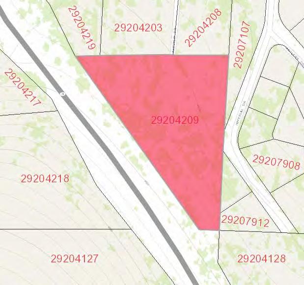
4 Lots/Land Current Status: ACTIVE MLS #: Address: City,St: 0 Lakeview Drive 9 Julian CA Zip: Parcel Map: APN#2: APN#3: APN#4: Virtual Tour L Current Price: Original Price: Sold Price:, Community: JULIAN Tentative Map: Neighborhood: Kentwood ll Complex: Restrictions: N/K MandRem None Known $175,000 $175,000 List Date: COE Date: Short Sale: Client Preferred 1 MT DOMLS 0 1/24/2016 No Directions: HWY 79 to Royal rt Lakeview rightat sign before Imperial to end A rare 3.37+/ acre home site in the Kentwood area of Julian. This site is contiguous with Highway 79, but accessed via Lakeview Drive. Very private and plenty of room to create your personalized weekend or full time residence. Home Owner Fees: Other Fees: Other Fee Type: CFD/Mello Roos: Total Monthly Fees: 0 Terms: Cash, Conventional Assessments: Fencing N/K Frontage Other/Remarks Irrigation N/K Sewer/Septic Perc Test Required Site Private Street, Street Paved 0.00 Approx # of Acres: Wtr Dist: MAJESTIC PINES INDEPENDEN Approx Lot SqFt: School Dist: Julian High School, Julian Union Lot Size: 2+ to 4 AC / Assessor Record Assessors Parcel: Boat Facilities: Zoning: Age Restrictions: N/K Additional Property Use Res/Business Use OK Terms Cash, Conventional Topography Level, Slope Gentle Utilities Available Above Ground Utilities to Site Above Ground, Electric, Propane, Telephone Water Meter on Property FrntgDim LotDimApx LndUse Animal Designation Code Approved Plans Jurisdiction L Presently on the property is a manufactured unit, which was purchased new, but never lived in. The manufactured home can be purchased separately. Copyright Sandicor, Inc. Information is not guaranteed Provided By: Gina Norte BRE Lic.#: CA /23/ :51 PM
5
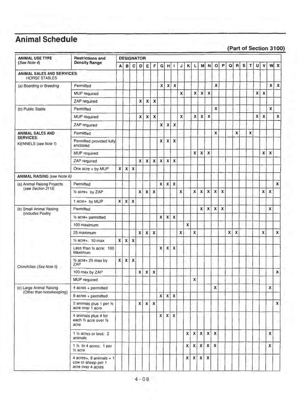
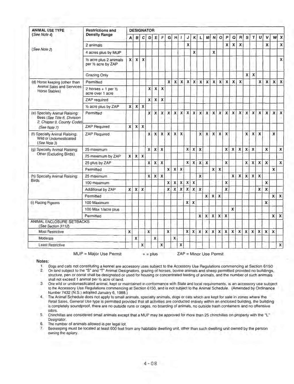
6 AGRICULTURAL USE REGULATIONS A70 LIMITED AGRICULTURAL USE REGULATIONS 2700 INTENT. The provisions of Section 2700 through Section 2709 inclusive, shall be known as the A70 Limited Agricultural Use Regulations. The A70 Use Regulations are intended to create and preserve areas intended primarily for agricultural crop production. Additionally, a limited number of small farm animals may be kept and agricultural products raised on the premises may be processed. Typically, the A70 Use Regulations would be applied to areas throughout the County to protect moderate to high quality agricultural land PERMITTED USES. The following use types are permitted by the A70 Use Regulations: a. Residential Use Types. Family Residential b. Civic Use Types. Essential Services Fire Protection Services (see Section 6905) c. Agricultural Use Types. Horticulture (all types) Tree Crops Row and Field Crops Packing and Processing: Limited Packing and Processing: Wholesale Limited Winery (Amended by Ord. No (N.S.) adopted ) (Amended by Ord. No (N.S.) adopted ) (Amended by Ord. No (N.S.) adopted ) (Amended by Ord. No (N.S.) effective (Urg. Ord.)) (Amended by Ord. No (N.S.) adopted ) 2703 PERMITTED USES SUBJECT TO LIMITATIONS. The following use types are permitted by the A70 Use Regulations subject to the applicable provisions of Section The number in quotes following the use type refers to the subsection of Section 2980 which applies. a. Residential Use Types Mobile home Residential "18" b. Commercial Use Types Animal Sales and Services: Veterinary (Large Animals) "6" Animal Sales and Services: Veterinary (Small Animals) "6" Cottage Industries "17" (see Section 6920) Recycling Collection Facility, Small "2" Recycling Processing Facility, Wood and Green Materials "3" c. Agricultural Use Types Packing and Processing: Boutique Winery "22" (see Section 6910) (Amended by Ord. No (N.S.) adopted ) (Amended by Ord. No (N.S.) adopted ) (Amended by Ord. No (N.S.) adopted ) (Amended by Ord. No (N.S.) adopted )
7 (Amended by Ord. No (N.S.) adopted ) (Amended by Ord. No (N.S.) adopted ) (Amended by Ord. No (N.S.) adopted ) 2704 USES SUBJECT TO A MINOR USE PERMIT. The following use types are permitted by the A70 Use Regulations upon issuance of a Minor Use Permit. a. Residential Use Types. Farm Labor Camps (See Section 6906); except that a Minor Use Permit shall not be required for a Farm Labor Camp for which a Use Permit is prohibited under Section or Section of the California Health and Safety Code. b. Civic Use Types. Law Enforcement Services Minor Impact Utilities Small Schools (Amended by Ord. No (N.S.) adopted ) (Amended by Ord. No (N.S.) adopted ) (Amended by Ord. No (N.S.) adopted ) (Amended by Ord. No (N.S.) effective (Urg. Ord.)) (Amended by Ord. No (N.S.) adopted ) (Amended by Ord. No (N.S.) adopted ) (Amended by Ord. No (N.S.) adopted ) (Amended by Ord. No (N.S.) adopted ) 2705 USES SUBJECT TO A MAJOR USE PERMIT. The following use types are permitted by the A70 Use Regulations upon issuance of a Major Use Permit a. Residential Use Types. Group Residential b. Civic Use Types. Administrative Services Ambulance Services Child Care Center Clinic Services Community Recreation Cultural Exhibits and Library Services Group Care Lodge, Fraternal and Civic Assembly Major Impact Services and Utilities Partying Services Postal Services Religious Assembly c. Commercial Use Types. Agricultural and Horticultural Sales (all types) Explosive Storage (see Section 6904) Participant Sports and Recreation: Outdoor Transient Habitation: Campground (see Section 6450) Transient Habitation: Resort (see Section 6400) d. Agricultural Use Types. Agricultural Equipment Storage
8 Packing and Processing: Winery Packing and Processing: General Packing and Processing: Support e. Extractive Use Types. Mining and Processing (see Section 6550) (Amended by Ord. No (N.S.) adopted ) (Amended by Ord. No (N.S.) adopted ) (Amended by Ord. No (N.S.) adopted ) (Amended by Ord. No (N.S.) adopted ) (Amended by Ord. No (N.S.) adopted ) (Amended by Ord. No (N.S.) adopted )
9
10
11
PROPERTY REPORT. RANCHO SAN FELIPE Olive Orchard. Donn Bree ADDRESS: 130 Acres along San Felipe Road, Warner Springs, CA 92086
 RANCHO SAN FELIPE Olive Orchard PROPERTY REPORT ADDRESS: 130 Acres along San Felipe Road, Warner Springs, CA 92086 DESCRIPTION: A 130 acre ranch property located in Rancho San Felipe is home to the San
PREMIER BUILDING SITE
 VALLEY CENTER PREMIER BUILDING SITE PROPERTY REPORT ADDRESS: 15625 Rim of the Valley, Valley Center, CA 92082 DESCRIPTION: 10.56 ACRE premier building site located in the heart of San Diego County s avocado
PROPERTY REPORT. RANCHO SAN FELIPE Olive Orchard. ADDRESS: 130 Acres along San Felipe Road, Warner Springs, CA 92086
 RANCHO SAN FELIPE Olive Orchard PROPERTY REPORT ADDRESS: 130 Acres along San Felipe Road, Warner Springs, CA 92086 DESCRIPTION: A 130 acre ranch property located in Rancho San Felipe is home to the San
PROPERTY REPORT Gina Norte. ADDRESS: 4554 Boulder Creek Road, Julian, CA 92036
 PROPERTY REPORT ADDRESS: 4554 Boulder Creek Road, Julian, CA 92036 DESCRIPTION: This stunning gated 41 +/ ACRE Equestrian Ranch is located in the heart of San Diego County s horse country. This turnkey
PROPERTY REPORT. ADDRESS: Mesa Grande Road, Santa Ysabel, CA 92070
 PROPERTY REPORT ADDRESS: 25394 Mesa Grande Road, Santa Ysabel, CA 92070 DESCRIPTION: A classic, custom ranch- style home situated on 3.23 usable acres in the sought after neighborhood of Mesa Grande, located
CHAPTER 4 - LAND USE CLASSIFICATIONS
 CHAPTER 4 - LAND USE CLASSIFICATIONS Four new land use classification categories are established in the Gualala Town Plan: Gualala Village Mixed Use; Gualala Highway Mixed Use; Gualala Planned Development
Rural Land Use Designations Kittitas County December 6, 2007 Draft
 KITTITAS COUNTY COMMUNITY DEVELOPMENT SERVICES 411 N. Ruby St., Suite 2, Ellensburg, WA 98926 CDS@CO.KITTITAS.WA.US Office (509) 962-7506 Fax (509) 962-7682 Rural Land Use Designations Kittitas County
NOTICE OF PREPARATION
 NOTICE OF PREPARATION DATE: January 6, 2016 TO: LEAD AGENCY: Responsible Agencies, Organizations, and Interested Parties Contact: Tyler Barrington, Principal Planner Planning Department Community Development
A Agricultural Zone.
 Page 1 of 5 5.2 - A Agricultural Zone. 5.20 General description. This zone provides for a wide range of agricultural and related uses as well as residential uses with low population densities and other
FOR SALE. 3.2-Acres Development Land PRESENTING. $1,390,000 Ballenger Creek Pike, Frederick, Maryland Location:
 FOR SALE $1,390,000 Ballenger Creek Pike, Frederick, Maryland 21703 3.2-Acres Development Land Great location with frontage on Ballenger Creek Pike. These 3.2 acres are situated next to Tuscarora High
Bull Canyon Ranch 2750 BULL CANYON ROAD, SANTA MARIA, CALIFORNIA PRESENTED FOR SALE BY: Rincon corporation
 Bull Canyon Ranch 2750 BULL CANYON ROAD, SANTA MARIA, CALIFORNIA PRESENTED FOR SALE BY: Rincon corporation THE FULL SERVICE REAL ESTATE COMPANY FOR THE AGRICULTURAL COMMUNITY Bull canyon ranch, santa maria
2 PLANNING AREA DESCRIPTION
 2 PLANNING AREA DESCRIPTION 2.1 LOCATION Hecker Pass is located within the City of Gilroy near the western city limit. Figure 2-1 illustrates the regional location of the Hecker Pass Area. Figure 2-1:
ARTICLE AGRICULTURAL DISTRICTS
 ARTICLE 6 AGRICULTURAL DISTRICTS SECTION 600 Intent The intent of this article is to specifically identify and protect the present and future viability and character of agricultural and rural lands. SECTION
EL DORADO COUNTY GENERAL PLAN PARKS AND RECREATION ELEMENT PRINCIPLE INTRODUCTION STATE AUTHORIZATION
 EL DORADO COUNTY GENERAL PLAN PARKS AND RECREATION ELEMENT PRINCIPLE The General Plan must identify the types of governmental services, including parks and recreation facilities, which are necessary to
THE LAND CONSERVANCY OF SAN LUIS OBISPO COUNTY
 THE LAND CONSERVANCY OF SAN LUIS OBISPO COUNTY WWW.LCSLO.ORG WHO WE ARE Through voluntary and collaborative measures, we work to permanently protect and enhance lands having important scenic, agricultural,
Referral Early Consultation
 DEPARTMENT OF PLANNING AND COMMUNITY DEVELOPMENT 1010 10 TH Street, Suite 3400, Modesto, CA 95354 Planning Phone: (209) 525-6330 Fax: (209) 525-5911 Building Phone: (209) 525-6557 Fax: (209) 525-7759 Date:
UPPER BRODHEAD CREEK PARADISE CREEK GREENWAY PLAN
 UPPER BRODHEAD CREEK PARADISE CREEK GREENWAY PLAN The Upper Brodhead & Paradise Creeks Greenway Cooperating Municipalities Mount Pocono Borough Paradise Township Barrett Township Price Township Funding
CHAPTER 10 AESTHETICS
 CHAPTER 10 AESTHETICS CHAPTER 10 AESTHETICS This section identifies and evaluates key visual resources in the project area to determine the degree of visual impact that would be attributable to the project.
CHAPTER 20: INSTITUTIONAL USE DEVELOPMENT STANDARDS
 CHAPTER 20: INSTITUTIONAL USE DEVELOPMENT STANDARDS ARTICLE 1: GENERAL INSTITUTIONAL USE STANDARDS 320-01. Application The provisions of this Chapter shall apply to the following uses in any zone: (e)
Lee Lake Community: Mixed-Use Area (MUA) Highest Density Residential (HHDR) Neighborhoods
 Highest Density Residential (HHDR) Neighborhoods") Specific Plans Specific Plans are highly customized policy or regulatory tools that provide a bridge between the General Plan and individual projects in a more areaspecific manner than is possible with
Specific Plans Specific Plans are highly customized policy or regulatory tools that provide a bridge between the General Plan and individual projects in a more areaspecific manner than is possible with
Business-Facts Summary - Workplace Business and Employment
 - Workplace Business and Employment Title Page Title Page Data Version: 2018 Feb (Internal) Report Generation Method: Single Analysis Area: 1789 STATE ST, SAN DIEGO, CA, 92101-2530 Reporting Detail: As
Exhibit A. 8:9 Scuffletown Rural Conservation District
 Exhibit A 8:9 Scuffletown Rural Conservation District 8:9.1 Intent and Purpose The Scuffletown Rural Conservation (SRC) District is intended to provide for residential development that supports the development
RECREATION AND OPEN SPACE VISION
 City of South Lake Tahoe General Plan Policy Document Recreation and Open Space Element INTRODUCTION This element provides the policy context for the City of South Lake Tahoe to achieve its vision for
CHAPTER 10-D GREATER MONTEREY PENINSULA AREA PLAN
 CHAPTER 10-D GREATER MONTEREY PENINSULA AREA PLAN GREATER MONTEREY PENINSULA AREA PLAN SUPPLEMENTAL POLICIES 1.0 - Land Use GMP-1.1 GMP-1.2 GMP-1.3 GMP-1.4 GMP-1.5 GMP-1.6 GMP-1.7 GMP-18.6 The County shall
4.1 AESTHETICS AND VISUAL QUALITY
 SCOPE AND METHODOLOGY 4.1 AESTHETICS AND VISUAL QUALITY This section evaluates the potential impacts to aesthetics and visual quality. Aesthetics refers to visual resources and the quality of what can
City of Nogales General Plan
 Open Space, Parks, Recreation and Trails City of Nogales General Plan Residents of Nogales place a high priority in the development of a comprehensive system of open space, parks, recreation and trails
Granada Hills-Knollwood New Community Plan Program Focus Group Land use Related Issues Summary*
 CIRCULATION TRAFFIC Traffic problems on Balboa Boulevard at the entrance and exit of the 118 freeway. Traffic problems around elementary, middle, and high schools. Traffic problems on Rinaldi Street being
Referral Early Consultation
 DEPARTMENT OF PLANNING AND COMMUNITY DEVELOPMENT 1010 10 th Street, Suite 3400, Modesto, CA 95354 Phone: 209.525.6330 Fax: 209.525.5911 Date: February 14, 2017 Referral Early Consultation To: Distribution
3.0 Cumulative Scenario and Methodology. 3.0 Cumulative Scenario and Methodology
 3.0 Cumulative Scenario and Methodology Under the CEQA Guidelines, a cumulative impact consists of an impact which is created as a result of the combination of the project evaluated in the environmental
Community Development Department Planning Division 1600 First Street + P.O. Box 660 Napa, CA (707)
") Community Development Department Planning Division 1600 First Street + P.O. Box 660 Napa, CA 94559-0660 (707) 257-9530 PLANNING COMMISSION STAFFREPORT December 4, 2014 AGENDA ITEM 8.A. 14-0138; ALTAMURA
Community Development Department Planning Division 1600 First Street + P.O. Box 660 Napa, CA 94559-0660 (707) 257-9530 PLANNING COMMISSION STAFFREPORT December 4, 2014 AGENDA ITEM 8.A. 14-0138; ALTAMURA
SCC PRD (2016) COUNTY PARK MASTER PLAN
 COUNTY PARK MASTER PLAN") SCC PRD (2016) COUNTY PARK MASTER PLAN MASTER PLAN UPDATE PARKS AND RECREATION COMMISSION NOVEMBER 7, 2018 PURPOSE OF THE MASTER PLAN The Sanborn County Park Master Plan will provide the Department with
SCC PRD (2016) COUNTY PARK MASTER PLAN MASTER PLAN UPDATE PARKS AND RECREATION COMMISSION NOVEMBER 7, 2018 PURPOSE OF THE MASTER PLAN The Sanborn County Park Master Plan will provide the Department with
8 Future Land Use Plan
 The Plan provides a land use framework for future development in the county through 2020. Future Land Use Plan The Future Land Use Plan provides a land use framework for future development in the county
PLANNING APPROVAL & PLANNED UNIT DEVELOPMENT Date: November 2, 2017
 PLANNING APPROVAL & PLANNED UNIT DEVELOPMENT Date: November 2, 2017 DEVELOPMENT NAME LOCATION Mobile Christian School 5900 Cottage Hill Road (North side of Cottage Hill Road, 230 ± West of Freemont Drive
Chapter 5: Recreation
 Chapter 5: Recreation Introduction and Setting Recreational opportunities within Nevada County are varied, ranging from public parks with intensively used active recreational facilities, to vast tracts
CHAPTER 10-D GREATER MONTEREY PENINSULA AREA PLAN
 CHAPTER 10-D GREATER MONTEREY PENINSULA AREA PLAN GREATER MONTEREY PENINSULA AREA PLAN SUPPLEMENTAL POLICIES 1.0 - Land Use GMP-1.1 GMP-1.2 GMP-1.3 GMP-1.4 GMP-1.5 GMP-1.6 GMP-1.7 The County shall overlay
-MENDOCINO COUNTY PLANNING AND BUILDING SERVICES- DIVISION II OF TITLE 20--COASTAL ZONING CODE
 CHAPTER 20.504 VISUAL RESOURCE AND SPECIAL TREATMENT AREAS Sec. 20.504.005 Applicability. Sec. 20.504.010 Purpose. Sec. 20.504.015 Highly Scenic Areas. Sec. 20.504.020 Special Communities and Neighborhoods.
Master Site Development Plan (MSDP) Rocky View County Campus at Balzac East
 Rocky View County Campus at Balzac East") Master Site Development Plan (MSDP) Rocky View County Campus at Balzac East Balzac East, Alberta July 2009 CONTENTS 1.0 purpose 1 2.0 guiding principles 2 3.0 site description 3 4.0 site analysis and county
Master Site Development Plan (MSDP) Rocky View County Campus at Balzac East Balzac East, Alberta July 2009 CONTENTS 1.0 purpose 1 2.0 guiding principles 2 3.0 site description 3 4.0 site analysis and county
Zoning Rewrite Implementation Worksession #3. Industrial Zones April 11, 2013
 Zoning Rewrite Implementation Worksession #3 Industrial Zones April 11, 2013 1 Industrial Zones Current I-1 942.19 acres 0.33% Current I-2 757.36 acres 0.27% Current I-3 (floating) 970.29 acres 0.34% Current
BISCUIT RUN PARK MASTER PLAN
 BOARD OF SUPERVISORS November 14, 2018 BISCUIT RUN PARK MASTER PLAN COUNTY OF ALBEMARLE ANHOLD ASSOCIATES Contents Project Introduction Property Background County Park Planning Process Existing Site &
MEMORANDUM OF UNDERSTANDING REGARDING MANAGEMENT OF THE LAKE MERCED TRACT
 June 24, 2011 Draft MEMORANDUM OF UNDERSTANDING REGARDING MANAGEMENT OF THE LAKE MERCED TRACT THIS MEMORANDUM OF UNDERSTANDING ("MOU"), dated for reference purposes only as of, 2011, is entered into by
Glenn Highway MP DSR. Landscape Narrative
 Glenn Highway MP 34-42 DSR Landscape Narrative Project Landscape Goals The Glenn Highway MP 34-42 Project extends through a variety of landscape types typical to the Matanuska-Susitna Valley. In general,
PC RESOLUTION NO
 PC RESOLUTION NO. 14-01-14-02 TENTATIVE TRACT MAP fttm) 17441. REZONE {RZ) 13-003, ARCHITECTURAL CONTROL (AC) 13-003, TREE REMOVAL PERMIT (TRP) 13-052. GRADING PLAN MODIFICATION (GPM) 13-002. CONDITIONAL
Chapter SAR, SENSITIVE AREA RESORT ZONE
 Moab Municipal Code Chapter 17.32 SAR, SENSITIVE AREA RESORT ZONE Page 1 of 8 Sections: 17.32.010 Objectives and characteristics. 17.32.020 Use regulations. Chapter 17.32 SAR, SENSITIVE AREA RESORT ZONE
Procedures IV. V. Rural Road Design Option
 i IV. Procedures A. All applicants required to prepare a Conservation Design Subdivision shall provide the Planning Board with a conceptual conventional subdivision design as well as a proposed layout
6 PORT SYDNEY SETTLEMENT AREA
 Section 6 Port Sydney Page 61 6 PORT SYDNEY SETTLEMENT AREA 6.1 Basis and Principles Village of Port Sydney Waterfront Community Existing Services 6.1.1 Port Sydney is an historic settlement that has developed
Annual lease of the tillable acreage for crops (soybeans and/or corn).
.") FOR SALE $895,000.00 11201 Hill Road, Woodsboro, Maryland 21798 Crop Farm with Subdivision Potential PRESENTING Location: 11201 Hill Road, Woodsboro, MD 132.2064 acre crop farm with extraordinary views,
FOR SALE $895,000.00 11201 Hill Road, Woodsboro, Maryland 21798 Crop Farm with Subdivision Potential PRESENTING Location: 11201 Hill Road, Woodsboro, MD 132.2064 acre crop farm with extraordinary views,
Only those portions of Title 18J that are proposed to be amended are shown. Remainder of text, maps, tables and/or figures is unchanged.
 Only those portions of Title 18J that are proposed to be amended are shown. Remainder of text, maps, tables and/or figures is unchanged. Title 18J DEVELOPMENT REGULATIONS DESIGN STANDARDS AND GUIDELINES
Santa Barbara County Planning Commission May 11 th, Cuyama Valley Conservancy vs. Troesh Diamond Rock Mine
 Santa Barbara County Planning Commission May 11 th, 2011 Cuyama Valley Conservancy vs. Troesh Diamond Rock Mine INTRODUCTION I Who Are We? The Cuyama Valley Conservance openly opposed the mine. In six
ALBEMARLE COUNTY CODE CHAPTER 18 ZONING SECTION 20A NEIGHBORHOOD MODEL - NMD
 CHAPTER 18 ZONING SECTION 20A NEIGHBORHOOD MODEL - NMD Sections: 20A.1 PURPOSE AND INTENT 20A.2 STATUS AS A PLANNED DEVELOPMENT DISTRICT 20A.5 CODES OF DEVELOPMENT 20A.6 PERMITTED USES 20A.7 RESIDENTIAL
20 Acres & Custom Spanish Home. Creston Hills Ranch
 20 Acres & Custom Spanish Home Creston Hills Ranch Situated in the gated community of Creston Hills Ranch, this 20 +/- acre property is the dream retreat that horse lovers, artists and those seeking a
CRESCENT GOLD 475± acres Putnam County, FL
 AGRIBUSINESS/RECREATION VALUE & APPEAL From an agricultural standpoint, this property offers 41 growing tunnels (in various sizes). These tunnels provide shade for growing beans, peppers, greens, tomatoes,
Limpia Creek Duck Pond. 25 acres, Jeff Davis County
 Limpia Creek Duck Pond 25 acres, Jeff Davis County Limpia Creek Duck Pond Hwy 17 N, 25 acres Jeff Davis County, Texas James Tammy King, Agent Broker Office King Land 432 & 426.2024 Water, LLC 432 426.2024
Rural Tourism. Amendments to the Non-Coastal Zoning Ordinance (Legislative Format)
") Page 1 of 7 Amendments to the Non-Coastal Zoning Ordinance (Legislative Format) ARTICLE 2 DEFINITIONS Article 2, Sec. 8102-0, DEFINITIONS, of the Ventura County Ordinance Code is hereby amended by revisions
Page 1 of 7 Amendments to the Non-Coastal Zoning Ordinance (Legislative Format) ARTICLE 2 DEFINITIONS Article 2, Sec. 8102-0, DEFINITIONS, of the Ventura County Ordinance Code is hereby amended by revisions
Venado Springs Ranch Bandera County, Texas, AC +/-
 Bandera County, Texas, 1400.0 AC +/- Main House Barn Foreman ' s House Pens Water Trough Windmill Spring Fence Primary Road Road Boundary Pond / Tank JIMMY & TRAVIS RENO P: (830)-329-1930 (830)-285-1728
Policy & Procedure Effective Date: Parks Department Page of
 City of Arvada Policy & Procedure Effective Date: Parks Department Page of TITLE: City of Arvada Prairie Dog Habitat Plan APPROVAL: PURPOSE: To establish a plan for the preservation of black-tailed prairie
EXECUTIVE SUMMARY. Introduction
 EXECUTIVE SUMMARY Introduction State Route 68 is a designated scenic route that connects the world-renowned Monterey Peninsula to US Highway 101 and the Salinas Valley. SR 68 is a key route for bicycle,
FOR SALE PRICE: $10,500,000 PLACER VINEYARDS - PROPERTY 12A Acres. South Line of Baseline Rd. East of Palladay Rd. Placer County, California
 PLACER VINEYARDS 12A BASELINE ROAD PALLADAY ROAD FOR SALE 193.40 Acres (8,424,504 SF) PRICE: $10,500,000 South Line of Baseline Rd. East of Palladay Rd. Placer County, California CUSHMAN & WAKEFIELD INC.
Pine Flat Lake Master Plan Update FACT SHEET September 2014
 Pine Flat Lake Master Plan Update FACT SHEET September 2014 PURPOSE AND OBJECTIVE The U.S. Army Corps of Engineers Sacramento District is revising the 1976 Pine Flat Lake Master Plan and is seeking public
Authority of the General Plan
 Authority of the General Plan This La Habra Heights General Plan will serve as the blueprint for future planning and development in the City. This General Plan describes the City s vision for the future
General Terms Property, as used to describe eligibility for the National Register of Historic Places:
 Key Definitions Historic Landscapes Compiled by Camille Fife and Barbara Wyatt The field of historic landscape preservation has generated a specific vocabulary. Definitions have been published by two National
1.0 Circulation Element
 5/9/18 1.0 Circulation Element 1.1 Introduction As growth and development occur in Apache County, enhancements to its circulation system will be necessary. With time, more roads will be paved and air and
MORRO BAY RANCH. Morro Bay, San Luis Obispo County, CA inf doorpropert ies.com if orniaout doorpropert ies.
 MORRO BAY RANCH Morro Bay, San Luis Obispo County, CA 707-445-4444 inf o@caout doorpropert ies.com www.cal if orniaout doorpropert ies.com 707-445-4444 www.calif www.calif orniaoutdoorproperties.com orniaoutdoorproperties.com
Referral Early Consultation
 DEPARTMENT OF PLANNING AND COMMUNITY DEVELOPMENT 1010 10 th Street, Suite 3400, Modesto, CA 95354 Phone: 209.525.6330 Fax: 209.525.5911 Date: April 29, 2016 Referral Early Consultation To: Distribution
ROARING FORK RAILROAD CORRIDOR
 ROARING FORK RAILROAD CORRIDOR CONSERVATION AREA ASSESSMENT August 28, 2017 Prepared For: Covenant Enforcement Commission Roaring Fork Transportation Authority Prepared By: NEWLAND PROJECT RESOURCES, INC
Joint Study Session of the Sutter County. March 2, 2009
 Joint Study Session of the Sutter County Board of Supervisors and Planning Commission March 2, 2009 CURRENT APPLICATION General Plan Amendment Specific Plan Specific Plan Appendices Utility Plans Transit/AQ
FOR SALE. Arvin Edison Vineyard & Open Land Gross Acres Kern County, CA
 Arvin Edison Vineyard & Open Land FOR SALE Property Highlights Arvin Edison Water Storage District Class I and II Soils Neighboring properties planted to almonds, vineyards, and citrus The information
12.0 LAND USE AND PLANNING
 This section describes the existing and proposed land uses and land use designations on each of the project sites and surrounding properties, and analyzes the potential for the project to conflict with
RED LODGE CREEK SHANE RIDGE RANCH
 RED LODGE CREEK SHANE RIDGE RANCH Roberts, Montana 59070 For additional details, contact: SCOTT R. GROSSKOPF Broker / Owner Member Landmark of Billings 1925 Grand Avenue, Ste. 144, Billings, MT 59102 Office:
REVISED AGENDA MATERIAL
 Jesse Arreguín City Councilmember, District 4 REVISED AGENDA MATERIAL Meeting Date: Item Number: 40 Item Description: Urban Agriculture Package Submitted by: Councilmember Jesse Arreguin Removed references
ALL FIELDS DETAIL GENERAL FEATURES
 ALL FIELDS DETAIL MLS # 160360 Status ACTIVE Type Farm/Ranch Area ELK RIVER AREA Asking Price $9,995,000 Address 52715 RCR 129 City Steamboat Springs State CO Zip 80487 Picture 18 Price/Tot Sq Ft $1,319.47
FOR SALE ± Acres Fresno County, California. CA BRE # Exclusively Presented By: Pearson Realty
 FOR SALE Orange Cove Citrus Ranch with Custom Home 127.33± Acres Fresno County, California Exclusively Presented By: Pearson Realty Variety of Citrus Plantings Frost Protection District and Well Water
Those uses will be allowed which are compatible with these overall objectives. 4. Public and private parks and playgrounds.
 CHAPTER 500. SECTION 503. ZONING STANDARDS A-C AGRICULTURAL DISTRICT 503.1. Purpose The purpose of the A-C Agricultural District is to preserve the rural and open character of various lands within the
Notice of Completion Form A See NOTE BELOW Mail to: State Clearinghouse, 1400 Tenth Street, Sac., CA / SCH #
 Notice of Completion Form A See NOTE BELOW Mail to: State Clearinghouse, 1400 Tenth Street, Sac., CA 95814 916/445-0613 SCH # 2002021130 Project Title: Pebble Beach Company s Del Monte Forest Preservation
PERMITTED USES/SPECIAL EXCEPTIONS See Zoning Ordinance for Specifics
 Rural & Urban Fringe Residence (R1) Minimum lot size 2 acres Single Family Residence (R2) One and Two Family Residence (R3) Minimum lot size 30,000 square feet Multiple Family Residence (R4) Minimum lot
STAFF REPORT FOR STANDARD COASTAL DEVELOPMENT PERMIT #CDP FEBRUARY 26, 2015 CPA - 1 PO BOX 238 APTOS, CA 94001
 STAFF REPORT FOR STANDARD COASTAL DEVELOPMENT PERMIT #CDP 2014-0030 FEBRUARY 26, 2015 CPA - 1 OWNER/APPLICANT: AGENT: REQUEST: HANS HEIM PO BOX 238 APTOS, CA 94001 JAMES HAY PO BOX 762 MENDOCINO, CA 95460
City Council Special Meeting. August 9, 2017
 DREAMPORT VILLAGES CASA GRANDE City Council Special Meeting August 9, 2017 Regional Gateway Commerce Center PAD Casa Grande Mountain Ranch PAD ARICA RD. OVERVIEW Dreamport Villages North 618 acre commercial
CHAPTER 21 NC-PUD NEIGHBORHOOD COMMERCIAL PUD DISTRICT
 CHAPTER 21 NC-PUD NEIGHBORHOOD COMMERCIAL PUD DISTRICT Section 21.1. Title and Purpose. The Neighborhood Commercial Planned Unit Development District, designated the, is intended for commercial uses of
Rural Conservation. Rural Conservation. Moving Forward ~ Planning Ahead. Introduction
 Introduction Minnehaha County expresses at least two very different styles of character. The City of Sioux Falls provides a strong urban atmosphere because of its size and regional status, and the unincorporated
3.10 Land Use and Planning
 3.10 This section describes the regulatory and environmental setting for land use and planning in the program and individual project areas. It also describes impacts on land use and planning that could
ROSE CREEK RANCH WINNEMUCCA, NV HUMBOLDT AND PERSHING COUNTY
 ROSE CREEK RANCH WINNEMUCCA, NV HUMBOLDT AND PERSHING COUNTY Industrial & Residential Development Site I-80 frontage @ Hwy 40 interchange Heart of Nevada Gold Country 2,743 acres Enjoy hunting, farming
EXECUTIVE SUMMARY DRAFT CHAPTER 1 INTRODUCTION EXECUTIVE SUMMARY
 CHAPTER 1 EXECUTIVE SUMMARY INTRODUCTION Through the joint efforts of the City of Tulsa planning staff and the Land Services division of Indian Nations Council of Governments (INCOG), the Berryhill Land
NEW CASTLE COUNTY S ZONING DISTRICTS
 NEW CASTLE COUNTY S ZONING DISTRICTS This is general information about New Castle County s zoning districts. The information included is by no means exhaustive or complete. Before designing plans to develop
SONOMA LOCAL AGENCY FORMATION COMMISSION
 For accessibility assistance with any of the following documents, please contact Sonoma LAFCO at (707) 565-2577 or email us at cynthia.olson@sonoma-county.org. SONOMA LOCAL AGENCY FORMATION COMMISSION
TREASURE COAST REGIONAL PLANNING COUNCIL M E M O R A N D U M. To: Council Members AGENDA ITEM 5I
 TREASURE COAST REGIONAL PLANNING COUNCIL M E M O R A N D U M To: Council Members AGENDA ITEM 5I From: Date: Subject: Staff December 12, 2008 Council Meeting Local Government Comprehensive Plan Review Town
Town of Rico Three Mile Plan for Annexation
 Town of Rico Three Mile Plan for Annexation 10.20.2010 Adopted by Resolution 2010-2 Produced with funding support from the Colorado Department of Local Affairs 2 Content Guide Introduction. 3 Annexation
Yates Cattle & Conservation Ranch
 Yates Cattle & Conservation Ranch Yates Cattle and Conservation Ranch 385 +/- acres Hays & Travis Counties, Texas James King, Agent Office 432.426.2024 James@KingLandWater.com Location There is a property
Bonners Ferry. Welcome to. Size: 3,788 sq. ft. Style: Single Story Taxes: $1,839 (2012)
") Welcome to Bonners Ferry Top of the World Panoramic River Views $449,995 (Price Reduced...) $449,995 Size: 3,788 sq. ft. Lot Size: 4.61 acres Style: Single Story Taxes: $1,839 (2012) Built: 1992 Information
Welcome to Bonners Ferry Top of the World Panoramic River Views $449,995 (Price Reduced...) $449,995 Size: 3,788 sq. ft. Lot Size: 4.61 acres Style: Single Story Taxes: $1,839 (2012) Built: 1992 Information
BAR AB RANCH. Valley Real Estate Yokohl Drive, Springville, CA 93265
 Valley Real Estate BAR AB RANCH 41666 Yokohl Drive, Springville, CA 93265 Beautiful 3,175 square foot custom home, built in 1982. This incredible home has cathedral open beam ceilings and a split floor
Applicant Name Phone / Fax / Address City State Zip Code . Property Owner Phone / Fax / Address City State Zip Code
 Master Development Plan Application Community Development Department City of Redmond 411 SW 9 th Street Redmond, Oregon 97756 541-923-7721 541-548-0706 FAX Master Development Plan Fee $38,862.52 File Number
Part 5. Environmental Protection Overlay District Regulations
 Part 5 Environmental Protection Overlay District Regulations Section 501. Statement of Intent. As established through the goals, objectives and policies of the Amity Township Comprehensive Plan, it is
CY-FAIR ISD Exemplary-rated schools
 -ACRE master planned community GREEN SPACE within a quarter-mile of every home -SQ.FT. community center CY-FAIR ISD Exemplary-rated schools Located in Cypress, Texas, Bridgeland is northwest Houston s
CITY OF CYPRESS 5275 Orange Avenue Cypress, California (714) DESIGN REVIEW COMMITTEE PERMIT PROCESS
 DESIGN REVIEW COMMITTEE PERMIT PROCESS") CITY OF CYPRESS 5275 Orange Avenue Cypress, California 90630 (714) 229-6720 DESIGN REVIEW COMMITTEE PERMIT PROCESS 1. Discuss project with Planning staff to determine zoning regulations, any unusual characteristics
CITY OF CYPRESS 5275 Orange Avenue Cypress, California 90630 (714) 229-6720 DESIGN REVIEW COMMITTEE PERMIT PROCESS 1. Discuss project with Planning staff to determine zoning regulations, any unusual characteristics
Zoning (sub): Road Surface: Paved. Cov./Rest: Yes. Water Frontage Location: Bedroom 4 Bath 1 Bath 2 Bath 3 Laundry Bonus
: Road Surface: Paved. Cov./Rest: Yes. Water Frontage Location: Bedroom 4 Bath 1 Bath 2 Bath 3 Laundry Bonus") MLS #: 20163895 Single Family 367 Ravenwood Lane, Sandpoint, ID 83864 $1,595,000 County: Bonner Sub Area: Sandpoint, Northeast Area: 1-Sandpoint Active Public Remarks Enjoy the complete Sandpoint Idaho
MLS #: 20163895 Single Family 367 Ravenwood Lane, Sandpoint, ID 83864 $1,595,000 County: Bonner Sub Area: Sandpoint, Northeast Area: 1-Sandpoint Active Public Remarks Enjoy the complete Sandpoint Idaho
Vision Statement Exercise
 Vision Statement Exercise 5 minutes Quickly read through both the Waterboro and Turner Vision Statements. Place [brackets] around the phrases that have a direct relationship to the form and pattern of
APPENDIX C. Architectural and Environmental Design Standards. Environmentally sensitive areas should be protected.
 APPENDIX C Architectural and Environmental Design Standards Environmentally Sensitive Areas Goal A. Environmentally sensitive areas should be protected. Development, such as roads, houses, and other structures,
REVISED AGENDA MATERIAL
 [First Last name] Councilmember District [District No.] REVISED AGENDA MATERIAL Meeting Date: March 15, 2015 Item Number: 7 Item Description: Adopt a First Reading of an Ordinance Revising BMC 14.48.200
PUD GUIDE FOR THE RED MOUNTAIN RANCH PLANNED UNIT DEVELOPMENT
 PUD GUIDE FOR THE RED MOUNTAIN RANCH PLANNED UNIT DEVELOPMENT Exhibit B to the Annexation and Development Agreement October 15, 2018 *Notes in red are intended for Town of Eagle review purposes and are
SECTION 2.0 INTRODUCTION
 SECTION 2.0 INTRODUCTION 2.1 PURPOSE AND SCOPE OF THE EIR Environmental Impact Reports (EIR) are informational documents which wil inform public agency decision-makers and the public generally of the significant
Draft Stillwater 2030 Comprehensive Plan- Goals and Policies
 Draft Stillwater 2030 Comprehensive Plan- Goals and Policies Instructions- Review each goal and policy and discuss with group any changes, deletions for additions to the list using your groups pen. Keep
3.1 AESTHETICS AND VISUAL SENSITIVITY
 This section of the Draft EIR discusses the potential impacts of the project on aesthetics and visual resources. The primary visual and aesthetic issues include the change in character to portions of the