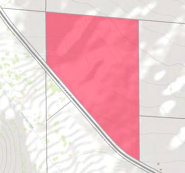
PROPERTY REPORT. RANCHO SAN FELIPE Olive Orchard. Donn Bree ADDRESS: 130 Acres along San Felipe Road, Warner Springs, CA 92086
|
|
|
- Joshua Gibbs
- 5 years ago
- Views:
Transcription


1 RANCHO SAN FELIPE Olive Orchard PROPERTY REPORT ADDRESS: 130 Acres along San Felipe Road, Warner Springs, CA DESCRIPTION: A 130 acre ranch property located in Rancho San Felipe is home to the San Felipe Olive Orchard, located at the base of the San Felipe Hills in the historic, feel-good back country community of Warner Springs, California. This scenic, well-manicured property offers three quarters of a mile frontage along San Felipe Road, Highway S2 in San Diego County. The infrastructure has been designed for an expandable orchard, a custom home, or an on site business. 700 olive trees containing 3 varieties, ranging in age from 5 9 years, line the driveway which leads to the large elevated home site. This incredible property is established for growth and development and is equipped with a well that produces abundant and pure water, 3,000 gallon storage tank, solar, irrigation, driveway, house pad and barn. PRICE: $495, APN: , 23, 24, & 26 MLS: CONTACT: Donn Bree Donn@Donn.com


2 130 Acres along San Felipe Road, Warner Springs, CA The 130 acre Rancho San Felipe is home to the San Felipe Olive Orchard, located at the base of the San Felipe Hills in the historic, feel good backcountry community of Warner Springs, California. The scenic, well manicured property offers three quarters of a mile frontage along San Felipe Road, Highway S2 in San Diego County. The infrastructure has been designed for an expandable orchard, a custom home, or an on site business. 700 hundred olive trees, ranging in age from 5 9 years, line the driveway which leads to the large elevated home site. The views capture the breathtaking valley, the quiet and scenic San Felipe Road and the Volcan Mountain Range. The well water is abundant and pure. The well is presently powered by a solar pump. Water reservoir includes a 3,000 gallon holding tank which is easily filled in full sun. Water volume can be increased by tying into public power, which is at the property boundary. Increasing the number of solar panels and installing a larger pump is also another option for increasing water production. Irrigation to the olive trees has already been established with current quality technology. The opportunities and expandability for this 130 acre, gently sloped, all usable property are limited only by your imagination. This is a perfect opportunity to create a unique development of olive groves, vineyards, and a quiet retreat for family and friends. CREB# NMLS# RED HAWK REALTY Junction Hwy 78 & Hwy 79 Santa Ysabel, CA Donn@Donn.com We Know The Back Country!

3 The Union of Economics and Lifestyle The terrain gently slopes, providing excellent drainage and soil creation environment. With only 5 acres planted, this site offers the perfect opportunity for expansion. Farming operations are centered around a metal barn on the property. Situated along the frontage of the property is the five acre San Felipe olive orchard, planted in 2007 and now entering peak production. Three varieties of olive oil trees evenly divide the orchard into three blocks totaling approximately 700 trees. The olive varieties are a Tuscan Blend of Frantoio, Casaliva, and Pendolino; the Spanish Arbequina; and the Greek Koroneiki. Production is already topping 2 tons and approaching 100 gallons of Extra Virgin Olive Oil, the highest quality and most expensive olive oil classification. We Know The Back Country!


4 Lots/Land Current Status: ACTIVE MLS #: Address: City,St: 0 San Felipe Rd. 0 Warner Springs CA Zip: Parcel Map: APN#2: APN#3: APN#4: Virtual Tour Current Price: Original Price: Sold Price: $495,000 $495,000, Community: WARNER SPRINGS Tentative Map: Neighborhood: San Felipe Complex: Restrictions: Call Agent MandRem None Known List Date: COE Date: Short Sale: Client Preferred 1 MT DOMLS 0 2/15/2017 No Directions: A 130 acre ranch property located in Rancho San Felipe is home to the San Felipe Olive Orchard, located at the base of the San Felipe Hills in the historic, feel-good back country community of Warner Springs, California. This scenic, well-manicured property offers three quarters of a mile frontage along San Felipe Road, Highway S2 in San Diego County. Home Owner Fees: Other Fees: 0.00 Other Fee Type: N/K CFD/Mello-Roos: Total Monthly Fees: 0 Terms: Other/Remarks Assessments: 0.00 Complex Features N/K Current Use Grove, Natural Vegetation, Residential Development Other/Remarks Fencing Partial, Other/Remarks Frontage N/K Highest Best Use Agriculture, Recreational, Residential Irrigation Drip Pool N/K Pool Heat None Known Possession Call Listing Agent Sewer/Septic Other/Remarks Site N/K Structures Out Buildings, Shed Approx # of Acres: Wtr Dist: OUT OF AREA Approx Lot SqFt: School Dist: Warner Lot Size: 20+ AC / Assessor Record Assessors Parcel: Boat Facilities: Zoning: Age Restrictions: N/K Additional Property Use Grove Prop. Restrictions Known None Known Home Owners Fee Includes N/K Terms Other/Remarks Topography Level, Rolling Utilities Available Other/Remarks Utilities to Site Other/Remarks View Mountains/Hills, Panoramic Water Well on Property FrntgDim LotDimApx LndUse Animal Designation Code Approved Plans Jurisdiction The infrastructure has been designed for an expandable orchard, a custom home, or an on-site business. 700 olive trees of 6 varieties, ranging in age from 5-9 years landscape the driveway which leads to the large elevated home site. This incredible property is established for growth and development and is equipped with a well that produces abundant and pure water, 3,000 gallon storage tank, solar, irrigation, driveway, house pad and barn.the infrastructure has been designed for an expandable orchard, a custom home, or an on site business. The well is capable of producing more water by electricity hook-up, which is available at the corner of the property. The irrigation to the olive trees has already been established with quality technology and gravity flow. An increase in solar panels and a larger pump is also another option for water proliferation. This is a perfect possibility to pioneer a property into a unique development of olive groves, vineyards, and a quiet retreat for family and friends. Copyright Sandicor, Inc. - Information is not guaranteed Provided By: Donn Bree BRE Lic.#: CA /15/ :15 PM

5 Donn Bree, Ph.D., G.R.I. POB 188 Santa Ysabel, CA PROPERTY DESCRIPTION RANCHO SAN FELIPE Olive Orchard & Home Site , 23, 24, & Acres along San Felipe Road Warner Springs, CA Page: 1 of 3
6 Donn Bree, Ph.D., G.R.I. POB 188 Santa Ysabel, CA INTRODUCTION & OVERVIEW The 130 acre Rancho San Felipe is home to the San Felipe Olive Orchard, located at the base of the San Felipe Hills in the historic, feel-good backcountry community of Warner Springs, California. This scenic, well-manicured property offers three quarters of a mile frontage along San Felipe Road, Highway S2 in San Diego County. The terrain gently slopes, providing excellent drainage and soil-creation environment. With only 5 acres planted, this site offers the perfect opportunity for expansion. Farming operations are centered around a metal barn on the property. Situated along the frontage of the property is the five acre San Felipe Olive Orchard, planted in 2007 and now entering peak production. Three varieties of olive oil trees evenly divide the orchard into three blocks totaling approximately 700 trees. The olive varieties are a Tuscan Blend of Frantoio, Casaliva, and Pendolino; the Spanish Arbequina; and the Greek Koroneiki. Production is already topping 2 tons and approaching 100 gallons of Extra Virgin Olive Oil, the highest quality and most expensive olive oil classification. The orchard is entirely irrigated using quality drip irrigation technology, controlling the irrigation of four independent sections of with automatic timers. Water for this automated and sustainable system is drawn from a quality water well using solar technology into a water storage tank at a rate of about 3000 gallons daily. Water is then delivered to the orchard through gravity, minimizing the power requirements for the operation and increasing the profits for the business. The San Felipe Olive Orchard and Home Site allows for expansion, growth and an amazing palate for gardens, varietal orchards, vineyards and multiple structures. The California olive oil demand is projected to grow 20% annually over the next decade. The trend of consumers favoring fresh local food is expected to continue. NATURAL SETTING Ancient oaks, high desert chaparral, and rock formations in the general area give this site privacy and character. The surrounding area is sparsely populated with custom homes and ranches blending into a landscape of rolling hills and valleys. Wildlife is abundant in the area: deer, turkey, bobcats and fox roam freely, while raptors and other rare species of animals can still be found here because of the abundance of water and cover in this rural area. Page: 2 of 3
7 Donn Bree, Ph.D., G.R.I. POB 188 Santa Ysabel, CA AREA INFORMATION Agriculture and tourism are the dominant economic activities in the Warner Springs area. Horse and cattle ranches are the backdrop for the landscape of light residential development. Gaming and recreational activities are important financial contributors, signaling the transition from agriculture into a more varied and stable economic base in the immediate area. Vineyards and tasting rooms have become a trending business in the back country of San Diego. Olive orchards are frequently inquired about in the real estate market, but not as commonly established in the east county of San Diego. There are many fine restaurants and lodging accommodations in the surrounding area of this centrally, yet privately located property. Recreation & Lifestyle There are many recreational activities available in the area: the California Riding and Hiking Trail, the popular Pacific Crest Trail, golfing at Warner s Ranch (which is presently undergoing a 50 million dollar renovation), Borrego Springs, hunting, fishing, dining, wine tasting along the nearby San Diego-Temecula wine country corridor, and a variety of other opportunities for each family member. The newly opened Santa Ysabel Open Space Preserve offers excellent riding trails connecting the Santa Ysabel, Wynola, and Julian communities. The famous Hale Observatory on Palomar Mountain is less than 30 minutes away. Page: 3 of 3
8
9
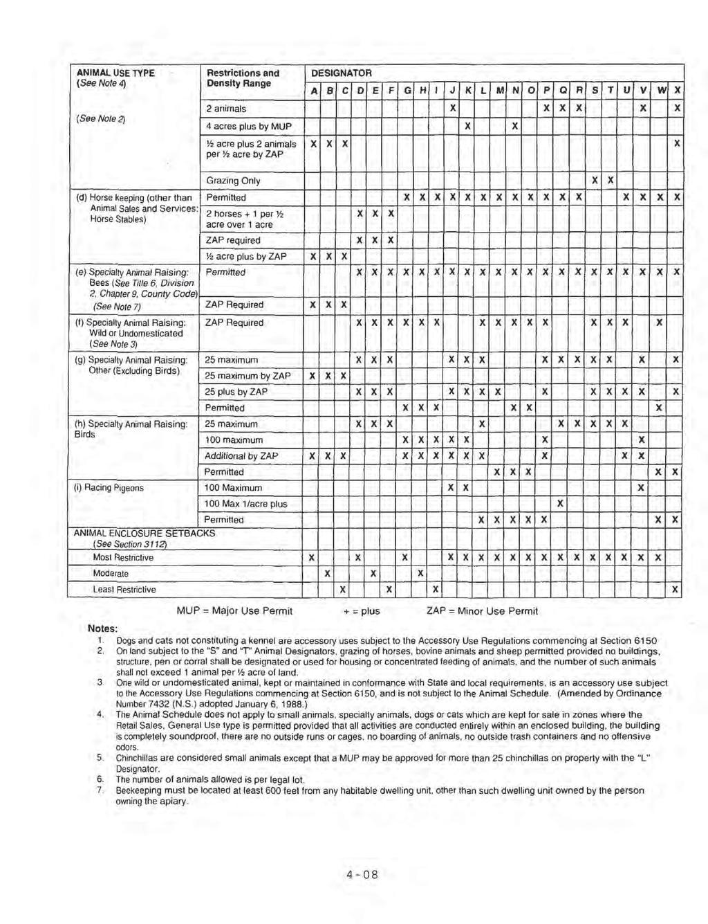
10 AGRICULTURAL USE REGULATIONS A70 LIMITED AGRICULTURAL USE REGULATIONS 2700 INTENT. The provisions of Section 2700 through Section 2709 inclusive, shall be known as the A70 Limited Agricultural Use Regulations. The A70 Use Regulations are intended to create and preserve areas intended primarily for agricultural crop production. Additionally, a limited number of small farm animals may be kept and agricultural products raised on the premises may be processed. Typically, the A70 Use Regulations would be applied to areas throughout the County to protect moderate to high quality agricultural land PERMITTED USES. The following use types are permitted by the A70 Use Regulations: a. Residential Use Types. Family Residential b. Civic Use Types. Essential Services Fire Protection Services (see Section 6905) c. Agricultural Use Types. Horticulture (all types) Tree Crops Row and Field Crops Packing and Processing: Limited Packing and Processing: Wholesale Limited Winery (Amended by Ord. No (N.S.) adopted ) (Amended by Ord. No (N.S.) adopted ) (Amended by Ord. No (N.S.) adopted ) (Amended by Ord. No (N.S.) effective (Urg. Ord.)) (Amended by Ord. No (N.S.) adopted ) 2703 PERMITTED USES SUBJECT TO LIMITATIONS. The following use types are permitted by the A70 Use Regulations subject to the applicable provisions of Section The number in quotes following the use type refers to the subsection of Section 2980 which applies. a. Residential Use Types Mobile home Residential "18" b. Commercial Use Types Animal Sales and Services: Veterinary (Large Animals) "6" Animal Sales and Services: Veterinary (Small Animals) "6" Cottage Industries "17" (see Section 6920) Recycling Collection Facility, Small "2" Recycling Processing Facility, Wood and Green Materials "3" c. Agricultural Use Types Packing and Processing: Boutique Winery "22" (see Section 6910) (Amended by Ord. No (N.S.) adopted ) (Amended by Ord. No (N.S.) adopted ) (Amended by Ord. No (N.S.) adopted ) (Amended by Ord. No (N.S.) adopted )
11 (Amended by Ord. No (N.S.) adopted ) (Amended by Ord. No (N.S.) adopted ) (Amended by Ord. No (N.S.) adopted ) 2704 USES SUBJECT TO A MINOR USE PERMIT. The following use types are permitted by the A70 Use Regulations upon issuance of a Minor Use Permit. a. Residential Use Types. Farm Labor Camps (See Section 6906); except that a Minor Use Permit shall not be required for a Farm Labor Camp for which a Use Permit is prohibited under Section or Section of the California Health and Safety Code. b. Civic Use Types. Law Enforcement Services Minor Impact Utilities Small Schools (Amended by Ord. No (N.S.) adopted ) (Amended by Ord. No (N.S.) adopted ) (Amended by Ord. No (N.S.) adopted ) (Amended by Ord. No (N.S.) effective (Urg. Ord.)) (Amended by Ord. No (N.S.) adopted ) (Amended by Ord. No (N.S.) adopted ) (Amended by Ord. No (N.S.) adopted ) (Amended by Ord. No (N.S.) adopted ) 2705 USES SUBJECT TO A MAJOR USE PERMIT. The following use types are permitted by the A70 Use Regulations upon issuance of a Major Use Permit a. Residential Use Types. Group Residential b. Civic Use Types. Administrative Services Ambulance Services Child Care Center Clinic Services Community Recreation Cultural Exhibits and Library Services Group Care Lodge, Fraternal and Civic Assembly Major Impact Services and Utilities Partying Services Postal Services Religious Assembly c. Commercial Use Types. Agricultural and Horticultural Sales (all types) Explosive Storage (see Section 6904) Participant Sports and Recreation: Outdoor Transient Habitation: Campground (see Section 6450) Transient Habitation: Resort (see Section 6400) d. Agricultural Use Types. Agricultural Equipment Storage
12 Packing and Processing: Winery Packing and Processing: General Packing and Processing: Support e. Extractive Use Types. Mining and Processing (see Section 6550) (Amended by Ord. No (N.S.) adopted ) (Amended by Ord. No (N.S.) adopted ) (Amended by Ord. No (N.S.) adopted ) (Amended by Ord. No (N.S.) adopted ) (Amended by Ord. No (N.S.) adopted ) (Amended by Ord. No (N.S.) adopted )

13
14
15
JULIAN HOME SITE PROPERTY REPORT
 ADDRESS: HWY 79, Julian, CA 92036 JULIAN HOME SITE PROPERTY REPORT DESCRIPTION: A rare 3.37+/- acre home site in the Kentwood area of Julian. This site is contiguous with Highway 79, but accessed via Lakeview
PROPERTY REPORT. RANCHO SAN FELIPE Olive Orchard. ADDRESS: 130 Acres along San Felipe Road, Warner Springs, CA 92086
 RANCHO SAN FELIPE Olive Orchard PROPERTY REPORT ADDRESS: 130 Acres along San Felipe Road, Warner Springs, CA 92086 DESCRIPTION: A 130 acre ranch property located in Rancho San Felipe is home to the San
PREMIER BUILDING SITE
 VALLEY CENTER PREMIER BUILDING SITE PROPERTY REPORT ADDRESS: 15625 Rim of the Valley, Valley Center, CA 92082 DESCRIPTION: 10.56 ACRE premier building site located in the heart of San Diego County s avocado
PROPERTY REPORT Gina Norte. ADDRESS: 4554 Boulder Creek Road, Julian, CA 92036
 PROPERTY REPORT ADDRESS: 4554 Boulder Creek Road, Julian, CA 92036 DESCRIPTION: This stunning gated 41 +/ ACRE Equestrian Ranch is located in the heart of San Diego County s horse country. This turnkey
PROPERTY REPORT. ADDRESS: Mesa Grande Road, Santa Ysabel, CA 92070
 PROPERTY REPORT ADDRESS: 25394 Mesa Grande Road, Santa Ysabel, CA 92070 DESCRIPTION: A classic, custom ranch- style home situated on 3.23 usable acres in the sought after neighborhood of Mesa Grande, located
2 PLANNING AREA DESCRIPTION
 2 PLANNING AREA DESCRIPTION 2.1 LOCATION Hecker Pass is located within the City of Gilroy near the western city limit. Figure 2-1 illustrates the regional location of the Hecker Pass Area. Figure 2-1:
CHAPTER 4 - LAND USE CLASSIFICATIONS
 CHAPTER 4 - LAND USE CLASSIFICATIONS Four new land use classification categories are established in the Gualala Town Plan: Gualala Village Mixed Use; Gualala Highway Mixed Use; Gualala Planned Development
CHAPTER 10 AESTHETICS
 CHAPTER 10 AESTHETICS CHAPTER 10 AESTHETICS This section identifies and evaluates key visual resources in the project area to determine the degree of visual impact that would be attributable to the project.
Rural Land Use Designations Kittitas County December 6, 2007 Draft
 KITTITAS COUNTY COMMUNITY DEVELOPMENT SERVICES 411 N. Ruby St., Suite 2, Ellensburg, WA 98926 CDS@CO.KITTITAS.WA.US Office (509) 962-7506 Fax (509) 962-7682 Rural Land Use Designations Kittitas County
20 Acres & Custom Spanish Home. Creston Hills Ranch
 20 Acres & Custom Spanish Home Creston Hills Ranch Situated in the gated community of Creston Hills Ranch, this 20 +/- acre property is the dream retreat that horse lovers, artists and those seeking a
STAFF REPORT FOR STANDARD COASTAL DEVELOPMENT PERMIT #CDP FEBRUARY 26, 2015 CPA - 1 PO BOX 238 APTOS, CA 94001
 STAFF REPORT FOR STANDARD COASTAL DEVELOPMENT PERMIT #CDP 2014-0030 FEBRUARY 26, 2015 CPA - 1 OWNER/APPLICANT: AGENT: REQUEST: HANS HEIM PO BOX 238 APTOS, CA 94001 JAMES HAY PO BOX 762 MENDOCINO, CA 95460
Bull Canyon Ranch 2750 BULL CANYON ROAD, SANTA MARIA, CALIFORNIA PRESENTED FOR SALE BY: Rincon corporation
 Bull Canyon Ranch 2750 BULL CANYON ROAD, SANTA MARIA, CALIFORNIA PRESENTED FOR SALE BY: Rincon corporation THE FULL SERVICE REAL ESTATE COMPANY FOR THE AGRICULTURAL COMMUNITY Bull canyon ranch, santa maria
Authority of the General Plan
 Authority of the General Plan This La Habra Heights General Plan will serve as the blueprint for future planning and development in the City. This General Plan describes the City s vision for the future
A Agricultural Zone.
 Page 1 of 5 5.2 - A Agricultural Zone. 5.20 General description. This zone provides for a wide range of agricultural and related uses as well as residential uses with low population densities and other
THE LAND CONSERVANCY OF SAN LUIS OBISPO COUNTY
 THE LAND CONSERVANCY OF SAN LUIS OBISPO COUNTY WWW.LCSLO.ORG WHO WE ARE Through voluntary and collaborative measures, we work to permanently protect and enhance lands having important scenic, agricultural,
NOTICE OF PREPARATION
 NOTICE OF PREPARATION DATE: January 6, 2016 TO: LEAD AGENCY: Responsible Agencies, Organizations, and Interested Parties Contact: Tyler Barrington, Principal Planner Planning Department Community Development
Chapter 5: Recreation
 Chapter 5: Recreation Introduction and Setting Recreational opportunities within Nevada County are varied, ranging from public parks with intensively used active recreational facilities, to vast tracts
Exhibit A. 8:9 Scuffletown Rural Conservation District
 Exhibit A 8:9 Scuffletown Rural Conservation District 8:9.1 Intent and Purpose The Scuffletown Rural Conservation (SRC) District is intended to provide for residential development that supports the development
Limpia Creek Duck Pond. 25 acres, Jeff Davis County
 Limpia Creek Duck Pond 25 acres, Jeff Davis County Limpia Creek Duck Pond Hwy 17 N, 25 acres Jeff Davis County, Texas James Tammy King, Agent Broker Office King Land 432 & 426.2024 Water, LLC 432 426.2024
4.1 AESTHETICS AND VISUAL QUALITY
 SCOPE AND METHODOLOGY 4.1 AESTHETICS AND VISUAL QUALITY This section evaluates the potential impacts to aesthetics and visual quality. Aesthetics refers to visual resources and the quality of what can
Master Site Development Plan (MSDP) Rocky View County Campus at Balzac East
 Rocky View County Campus at Balzac East") Master Site Development Plan (MSDP) Rocky View County Campus at Balzac East Balzac East, Alberta July 2009 CONTENTS 1.0 purpose 1 2.0 guiding principles 2 3.0 site description 3 4.0 site analysis and county
Master Site Development Plan (MSDP) Rocky View County Campus at Balzac East Balzac East, Alberta July 2009 CONTENTS 1.0 purpose 1 2.0 guiding principles 2 3.0 site description 3 4.0 site analysis and county
-MENDOCINO COUNTY PLANNING AND BUILDING SERVICES- DIVISION II OF TITLE 20--COASTAL ZONING CODE
 CHAPTER 20.504 VISUAL RESOURCE AND SPECIAL TREATMENT AREAS Sec. 20.504.005 Applicability. Sec. 20.504.010 Purpose. Sec. 20.504.015 Highly Scenic Areas. Sec. 20.504.020 Special Communities and Neighborhoods.
ALBEMARLE COUNTY CODE CHAPTER 18 ZONING SECTION 20A NEIGHBORHOOD MODEL - NMD
 CHAPTER 18 ZONING SECTION 20A NEIGHBORHOOD MODEL - NMD Sections: 20A.1 PURPOSE AND INTENT 20A.2 STATUS AS A PLANNED DEVELOPMENT DISTRICT 20A.5 CODES OF DEVELOPMENT 20A.6 PERMITTED USES 20A.7 RESIDENTIAL
Applicant Name Phone / Fax / Address City State Zip Code . Property Owner Phone / Fax / Address City State Zip Code
 Master Development Plan Application Community Development Department City of Redmond 411 SW 9 th Street Redmond, Oregon 97756 541-923-7721 541-548-0706 FAX Master Development Plan Fee $38,862.52 File Number
ARTICLE AGRICULTURAL DISTRICTS
 ARTICLE 6 AGRICULTURAL DISTRICTS SECTION 600 Intent The intent of this article is to specifically identify and protect the present and future viability and character of agricultural and rural lands. SECTION
UPPER BRODHEAD CREEK PARADISE CREEK GREENWAY PLAN
 UPPER BRODHEAD CREEK PARADISE CREEK GREENWAY PLAN The Upper Brodhead & Paradise Creeks Greenway Cooperating Municipalities Mount Pocono Borough Paradise Township Barrett Township Price Township Funding
CHAPTER 20: INSTITUTIONAL USE DEVELOPMENT STANDARDS
 CHAPTER 20: INSTITUTIONAL USE DEVELOPMENT STANDARDS ARTICLE 1: GENERAL INSTITUTIONAL USE STANDARDS 320-01. Application The provisions of this Chapter shall apply to the following uses in any zone: (e)
Lee Lake Community: Mixed-Use Area (MUA) Highest Density Residential (HHDR) Neighborhoods
 Highest Density Residential (HHDR) Neighborhoods") Specific Plans Specific Plans are highly customized policy or regulatory tools that provide a bridge between the General Plan and individual projects in a more areaspecific manner than is possible with
Specific Plans Specific Plans are highly customized policy or regulatory tools that provide a bridge between the General Plan and individual projects in a more areaspecific manner than is possible with
1.0 Circulation Element
 5/9/18 1.0 Circulation Element 1.1 Introduction As growth and development occur in Apache County, enhancements to its circulation system will be necessary. With time, more roads will be paved and air and
EXECUTIVE SUMMARY. Introduction
 EXECUTIVE SUMMARY Introduction State Route 68 is a designated scenic route that connects the world-renowned Monterey Peninsula to US Highway 101 and the Salinas Valley. SR 68 is a key route for bicycle,
FOR SALE. 3.2-Acres Development Land PRESENTING. $1,390,000 Ballenger Creek Pike, Frederick, Maryland Location:
 FOR SALE $1,390,000 Ballenger Creek Pike, Frederick, Maryland 21703 3.2-Acres Development Land Great location with frontage on Ballenger Creek Pike. These 3.2 acres are situated next to Tuscarora High
SCC PRD (2016) COUNTY PARK MASTER PLAN
 COUNTY PARK MASTER PLAN") SCC PRD (2016) COUNTY PARK MASTER PLAN MASTER PLAN UPDATE PARKS AND RECREATION COMMISSION NOVEMBER 7, 2018 PURPOSE OF THE MASTER PLAN The Sanborn County Park Master Plan will provide the Department with
SCC PRD (2016) COUNTY PARK MASTER PLAN MASTER PLAN UPDATE PARKS AND RECREATION COMMISSION NOVEMBER 7, 2018 PURPOSE OF THE MASTER PLAN The Sanborn County Park Master Plan will provide the Department with
Everett Prune Farm Glenn County, California
 Everett Prune Farm Glenn County, California Proudly Offered By 707 Merchant Street, Suite 100, Vacaville, Ca 95688 (707) 455-4444 Office (707) 455-0455 Fax info@caoutdoorproperties.com www.californiaoutdoorproperties.com
General Terms Property, as used to describe eligibility for the National Register of Historic Places:
 Key Definitions Historic Landscapes Compiled by Camille Fife and Barbara Wyatt The field of historic landscape preservation has generated a specific vocabulary. Definitions have been published by two National
FOR SALE PRICE: $10,500,000 PLACER VINEYARDS - PROPERTY 12A Acres. South Line of Baseline Rd. East of Palladay Rd. Placer County, California
 PLACER VINEYARDS 12A BASELINE ROAD PALLADAY ROAD FOR SALE 193.40 Acres (8,424,504 SF) PRICE: $10,500,000 South Line of Baseline Rd. East of Palladay Rd. Placer County, California CUSHMAN & WAKEFIELD INC.
EL DORADO COUNTY GENERAL PLAN PARKS AND RECREATION ELEMENT PRINCIPLE INTRODUCTION STATE AUTHORIZATION
 EL DORADO COUNTY GENERAL PLAN PARKS AND RECREATION ELEMENT PRINCIPLE The General Plan must identify the types of governmental services, including parks and recreation facilities, which are necessary to
Business-Facts Summary - Workplace Business and Employment
 - Workplace Business and Employment Title Page Title Page Data Version: 2018 Feb (Internal) Report Generation Method: Single Analysis Area: 1789 STATE ST, SAN DIEGO, CA, 92101-2530 Reporting Detail: As
HARTMAN RANCH ESTATE
 Lake Valley, NM ~ 50 acres ~ Appropriately $789,000 Scenic acres of rolling hills... T his is one of the most beautiful, energy efficient homes you will ever see, in the foothills of southwest New Mexico.
CHAPTER 10-D GREATER MONTEREY PENINSULA AREA PLAN
 CHAPTER 10-D GREATER MONTEREY PENINSULA AREA PLAN GREATER MONTEREY PENINSULA AREA PLAN SUPPLEMENTAL POLICIES 1.0 - Land Use GMP-1.1 GMP-1.2 GMP-1.3 GMP-1.4 GMP-1.5 GMP-1.6 GMP-1.7 GMP-18.6 The County shall
City of Nogales General Plan
 Open Space, Parks, Recreation and Trails City of Nogales General Plan Residents of Nogales place a high priority in the development of a comprehensive system of open space, parks, recreation and trails
ARMOUR RANCH ROAD SANTA YNEZ VALLEY, CALIFORNIA
 SUZANNE PERKINS 805.895.2138 www.suzanneperkins.com SUZANNE@SUZANNEPERKINS.COM All information deemed reliable, but not guaranteed Brochure: Thomas Ploch Productions 805.895.9639 ARMOUR RANCH ROAD SANTA
Policy & Procedure Effective Date: Parks Department Page of
 City of Arvada Policy & Procedure Effective Date: Parks Department Page of TITLE: City of Arvada Prairie Dog Habitat Plan APPROVAL: PURPOSE: To establish a plan for the preservation of black-tailed prairie
ROSE CREEK RANCH WINNEMUCCA, NV HUMBOLDT AND PERSHING COUNTY
 ROSE CREEK RANCH WINNEMUCCA, NV HUMBOLDT AND PERSHING COUNTY Industrial & Residential Development Site I-80 frontage @ Hwy 40 interchange Heart of Nevada Gold Country 2,743 acres Enjoy hunting, farming
GRAND COUNTY Planning Commission April 27, :00 P.M. Regular Meeting GRAND CENTER North End Meeting Room 182 No. 500 W.
 Type of Meeting: Facilitator: Attendees: Regular Meeting Dave Tubbs, Chair GRAND COUNTY Planning Commission April 27, 2016 6:00 P.M. Regular Meeting GRAND CENTER North End Meeting Room 182 No. 500 W.,
Nob Hill Pipeline Improvements Project EIR
 Section 3.1 Aesthetics This section addresses the visual aspects that may affect the views experienced by the public, including the potential to impact the existing character of each area that comprises
Chapter SAR, SENSITIVE AREA RESORT ZONE
 Moab Municipal Code Chapter 17.32 SAR, SENSITIVE AREA RESORT ZONE Page 1 of 8 Sections: 17.32.010 Objectives and characteristics. 17.32.020 Use regulations. Chapter 17.32 SAR, SENSITIVE AREA RESORT ZONE
MASTER PLAN. 201 Planning Concepts. Chapter 2
 Chapter 2 MASTER PLAN 201 Planning Concepts 202 Master Land Use Plan 203 Affordable Housing Program 204 Parks, Open Space, and Recreation Trails 205 Grading Concept 206 Circulation Plan 207 Landscape Concept
Rural Tourism. Amendments to the Non-Coastal Zoning Ordinance (Legislative Format)
") Page 1 of 7 Amendments to the Non-Coastal Zoning Ordinance (Legislative Format) ARTICLE 2 DEFINITIONS Article 2, Sec. 8102-0, DEFINITIONS, of the Ventura County Ordinance Code is hereby amended by revisions
Page 1 of 7 Amendments to the Non-Coastal Zoning Ordinance (Legislative Format) ARTICLE 2 DEFINITIONS Article 2, Sec. 8102-0, DEFINITIONS, of the Ventura County Ordinance Code is hereby amended by revisions
ALL FIELDS DETAIL GENERAL FEATURES
 ALL FIELDS DETAIL MLS # 160360 Status ACTIVE Type Farm/Ranch Area ELK RIVER AREA Asking Price $9,995,000 Address 52715 RCR 129 City Steamboat Springs State CO Zip 80487 Picture 18 Price/Tot Sq Ft $1,319.47
Rural Conservation. Rural Conservation. Moving Forward ~ Planning Ahead. Introduction
 Introduction Minnehaha County expresses at least two very different styles of character. The City of Sioux Falls provides a strong urban atmosphere because of its size and regional status, and the unincorporated
City of Lafayette Staff Report
 City of Lafayette Staff Report For: By: Design Review Commission Greg Wolff, Senior Planner Meeting Date: April 27, 2015 Subject: SS03-15 Gundi & Peter Younger (Owners), R-40 Zoning: Request for a Study
garden\garden: A Comparison in Santa Monica
 garden\garden: A Comparison in Santa Monica Size & Type of Project: Each residential garden is approximately 1900 square feet in area Location: Santa Monica, California Budget: $29,100 (for both gardens)
Referral Early Consultation
 DEPARTMENT OF PLANNING AND COMMUNITY DEVELOPMENT 1010 10 th Street, Suite 3400, Modesto, CA 95354 Phone: 209.525.6330 Fax: 209.525.5911 Date: February 14, 2017 Referral Early Consultation To: Distribution
CHAPTER 10-D GREATER MONTEREY PENINSULA AREA PLAN
 CHAPTER 10-D GREATER MONTEREY PENINSULA AREA PLAN GREATER MONTEREY PENINSULA AREA PLAN SUPPLEMENTAL POLICIES 1.0 - Land Use GMP-1.1 GMP-1.2 GMP-1.3 GMP-1.4 GMP-1.5 GMP-1.6 GMP-1.7 The County shall overlay
3.10 Land Use and Planning
 3.10 This section describes the regulatory and environmental setting for land use and planning in the program and individual project areas. It also describes impacts on land use and planning that could
3.10 LAND USE SETTING PROJECT SITE EXISTING LAND USE DESIGNATIONS AND ZONING. General Plan Land Use Designations.
 This section of the Draft EIR addresses the existing land uses on and adjacent to the project site and discusses the potential impacts of the proposed project on existing land uses. Key issues addressed
37 Interlaken A Vision To The Future
 37 Interlaken A Vision To The Future The History The Beckwith or Bonnie Briar Estate is one of the original Berkshires Cottages. It was built in 1892 and designed by architect and wealthy owner Leonard
A DELIGHTFUL COUNTRY HOUSE SETTLED IN THE MIDDLE OF ITS OWN EXTENSIVE LAND AND OVERLOOKING OUTSTANDING COUNTRYSIDE
 FIDDINGTON FARM A DELIGHTFUL COUNTRY HOUSE SETTLED IN THE MIDDLE OF ITS OWN EXTENSIVE LAND AND OVERLOOKING OUTSTANDING COUNTRYSIDE available in 4 lots main house Entrance hall Kitchen/breakfast room Dining/living
City Council Special Meeting. August 9, 2017
 DREAMPORT VILLAGES CASA GRANDE City Council Special Meeting August 9, 2017 Regional Gateway Commerce Center PAD Casa Grande Mountain Ranch PAD ARICA RD. OVERVIEW Dreamport Villages North 618 acre commercial
Those uses will be allowed which are compatible with these overall objectives. 4. Public and private parks and playgrounds.
 CHAPTER 500. SECTION 503. ZONING STANDARDS A-C AGRICULTURAL DISTRICT 503.1. Purpose The purpose of the A-C Agricultural District is to preserve the rural and open character of various lands within the
Improve Neighborhood Design and Reduce Non Point Source Water Pollution
 HOW TO Planning Guide Improve Neighborhood Design and Reduce Non Point Source Water Pollution This document was funded by a grant from the New Hampshire Coastal Program with funding from the National Oceanic
PC RESOLUTION NO
 PC RESOLUTION NO. 14-01-14-02 TENTATIVE TRACT MAP fttm) 17441. REZONE {RZ) 13-003, ARCHITECTURAL CONTROL (AC) 13-003, TREE REMOVAL PERMIT (TRP) 13-052. GRADING PLAN MODIFICATION (GPM) 13-002. CONDITIONAL
BAR AB RANCH. Valley Real Estate Yokohl Drive, Springville, CA 93265
 Valley Real Estate BAR AB RANCH 41666 Yokohl Drive, Springville, CA 93265 Beautiful 3,175 square foot custom home, built in 1982. This incredible home has cathedral open beam ceilings and a split floor
40 Years: A Brief History of Whistler - The Role of Long Term Planning Colorado Association of Ski Towns. January 20, 2016
 40 Years: A Brief History of Whistler - The Role of Long Term Planning Colorado Association of Ski Towns January 20, 2016 Presentation overview Whistler s unique history Building of Whistler Premise, purpose
Yates Cattle & Conservation Ranch
 Yates Cattle & Conservation Ranch Yates Cattle and Conservation Ranch 385 +/- acres Hays & Travis Counties, Texas James King, Agent Office 432.426.2024 James@KingLandWater.com Location There is a property
Ten Mile Creek Planning Area
 PLANNING AREA POLICIES TEN MILE CREEK Ten Mile Creek Planning Area Location and Context The Ten Mile Creek Planning Area ( Ten Mile Creek area ) is located south of the current Boise AOCI, generally south
Town of Rico Three Mile Plan for Annexation
 Town of Rico Three Mile Plan for Annexation 10.20.2010 Adopted by Resolution 2010-2 Produced with funding support from the Colorado Department of Local Affairs 2 Content Guide Introduction. 3 Annexation
MORRO BAY RANCH. Morro Bay, San Luis Obispo County, CA inf doorpropert ies.com if orniaout doorpropert ies.
 MORRO BAY RANCH Morro Bay, San Luis Obispo County, CA 707-445-4444 inf o@caout doorpropert ies.com www.cal if orniaout doorpropert ies.com 707-445-4444 www.calif www.calif orniaoutdoorproperties.com orniaoutdoorproperties.com
CRESCENT GOLD 475± acres Putnam County, FL
 AGRIBUSINESS/RECREATION VALUE & APPEAL From an agricultural standpoint, this property offers 41 growing tunnels (in various sizes). These tunnels provide shade for growing beans, peppers, greens, tomatoes,
4 C OMMUNITY D ISTRICTS
 4 C OMMUNITY D ISTRICTS N ew development in the Area will include many different types of land uses, including a destination retail area that attracts people from all over the region; recreation opportunities
Land Use. Chapter 8: Introduction. Land Use Vision. Section I: Current Land Use 8-1
 Introduction Land use is the defining element of the comprehensive plan. It will serve as a framework for decision makers, guiding future growth and development in the Town of Oconto Falls. This chapter
3.0 Cumulative Scenario and Methodology. 3.0 Cumulative Scenario and Methodology
 3.0 Cumulative Scenario and Methodology Under the CEQA Guidelines, a cumulative impact consists of an impact which is created as a result of the combination of the project evaluated in the environmental
3.1 AESTHETICS Background and Methodology
 3.1 AESTHETICS 3.1.1 Background and Methodology 3.1.1.1 Regulatory Context The California Environmental Quality Act (CEQA) requires that project sponsors evaluate the project s potential to cause aesthetic
Site Design (Table 2) Fact Sheet & Focus Questions:
 Fact Sheet & Focus Questions:") Site Design (Table 2) Fact Sheet & Focus Questions: BACKGROUND WHAT IS SITE DESIGN? Site design refers to the arrangement of buildings and open spaces on adjacent sites to maximize the shared benefits
Site Design (Table 2) Fact Sheet & Focus Questions: BACKGROUND WHAT IS SITE DESIGN? Site design refers to the arrangement of buildings and open spaces on adjacent sites to maximize the shared benefits
SITE INTRODUCTIONS AND OVERVIEW
 SITE INTRODUCTIONS AND OVERVIEW The City s formal Open Space Program was established in 1990 to implement long-standing policies that called for the protection of the farmlands and wild areas that surround
REVISED AGENDA MATERIAL
 Jesse Arreguín City Councilmember, District 4 REVISED AGENDA MATERIAL Meeting Date: Item Number: 40 Item Description: Urban Agriculture Package Submitted by: Councilmember Jesse Arreguin Removed references
OCEANSIDE DEVELOPER S CONFERENCE
 1 AGENDA OCEANSIDE DEVELOPER S CONFERENCE Tuesday, November 15th, 2016, 8:30 a.m. City Hall South, 1 st Floor, Guajome Room 1. 8:30-9:30 a.m. Proposed 57 lot residential subdivision of an approximately
RED LODGE CREEK SHANE RIDGE RANCH
 RED LODGE CREEK SHANE RIDGE RANCH Roberts, Montana 59070 For additional details, contact: SCOTT R. GROSSKOPF Broker / Owner Member Landmark of Billings 1925 Grand Avenue, Ste. 144, Billings, MT 59102 Office:
I. INTRODUCTION. A. Consistency with Other Elements
 OPEN SPACE ELEMENT I. INTRODUCTION The Open Space Element identifies the County s open space land, and establishes guiding policies for the preservation and conservation of land within the County that
Annual lease of the tillable acreage for crops (soybeans and/or corn).
.") FOR SALE $895,000.00 11201 Hill Road, Woodsboro, Maryland 21798 Crop Farm with Subdivision Potential PRESENTING Location: 11201 Hill Road, Woodsboro, MD 132.2064 acre crop farm with extraordinary views,
FOR SALE $895,000.00 11201 Hill Road, Woodsboro, Maryland 21798 Crop Farm with Subdivision Potential PRESENTING Location: 11201 Hill Road, Woodsboro, MD 132.2064 acre crop farm with extraordinary views,
Notice of Completion Form A See NOTE BELOW Mail to: State Clearinghouse, 1400 Tenth Street, Sac., CA / SCH #
 Notice of Completion Form A See NOTE BELOW Mail to: State Clearinghouse, 1400 Tenth Street, Sac., CA 95814 916/445-0613 SCH # 2002021130 Project Title: Pebble Beach Company s Del Monte Forest Preservation
PLANNING APPROVAL & PLANNED UNIT DEVELOPMENT Date: November 2, 2017
 PLANNING APPROVAL & PLANNED UNIT DEVELOPMENT Date: November 2, 2017 DEVELOPMENT NAME LOCATION Mobile Christian School 5900 Cottage Hill Road (North side of Cottage Hill Road, 230 ± West of Freemont Drive
SECTION 4 OPEN SPACE ELEMENT
 Open Space Element SECTION 4 OPEN SPACE ELEMENT c 4.1 INTRODUCTION 4.1.1 SCOPE OF ELEMENT The state requires every general plan to have an open space element Section 65302{e». The open space element must
Peppertree Business Park
 12.55 Net Acres Corporate/Institution Development Site PEPPERTREE BUSINESS PARK IS A UNIQUELY BEAUTIFUL MASTER PLANNED DEVELOPMENT SITE NESTLED AT THE FOOT OF THE SIMI HILLS WITH MEIER CREEK STREAMBED
PARK CITY MUNICIPAL CODE TABLE OF CONTENTS TITLE 15 LAND MANAGEMENT CODE - CHAPTER 2.21
 PARK CITY MUNICIPAL CODE TABLE OF CONTENTS TITLE 15 LAND MANAGEMENT CODE - CHAPTER 2.21 TITLE 15 - LAND MANAGEMENT CODE CHAPTER 2.21 - SENSITIVE LAND OVERLAY ZONE (SLO) REGULATIONS 15-2.21-1. PURPOSE...1
SECTION 39. Title V, Chapter 6, Article 2, added to the Zoning Code of Sacramento County shall read as follows: GREENBACK LANE SPECIAL PLANNING AREA
 SECTION 39. Title V, Chapter 6, Article 2, added to the Zoning Code of Sacramento County shall read as follows: GREENBACK LANE SPECIAL PLANNING AREA 506-20. INTENT. It is the intent of the Board of Supervisors
Santa Cruz River Master Plan. Presented to the Arizona Floodplain Management Association Spring Conference June 8-10, 2011
 Santa Cruz River Master Plan Presented to the Arizona Floodplain Management Association Spring Conference June 8-10, 2011 Introduction Who is FICO? 2 Project Team Kimley-Horn and Associates, Inc. River
3. VISION AND GOALS. Vision Statement. Goals, Objectives and Policies
 Vision Statement Queen Creek s interconnected network of parks, trails, open spaces and recreation opportunities provide safe and diverse activities and programs that sustain its unique, small town, equestrian
Venado Springs Ranch Bandera County, Texas, AC +/-
 Bandera County, Texas, 1400.0 AC +/- Main House Barn Foreman ' s House Pens Water Trough Windmill Spring Fence Primary Road Road Boundary Pond / Tank JIMMY & TRAVIS RENO P: (830)-329-1930 (830)-285-1728
7. Maintaining small animals and fowl for the occupant's use or need only, not to exceed a ratio of twenty (20) per acre.
 per acre.") CHAPTER 500. SECTION 505. ZONING STANDARDS A-R AGRICULTURAL-RESIDENTIAL DISTRICT 505.1. Purpose The purpose of the A-R Agricultural-Residential District is to allow the development of relatively large
CHAPTER 500. SECTION 505. ZONING STANDARDS A-R AGRICULTURAL-RESIDENTIAL DISTRICT 505.1. Purpose The purpose of the A-R Agricultural-Residential District is to allow the development of relatively large
CY-FAIR ISD Exemplary-rated schools
 -ACRE master planned community GREEN SPACE within a quarter-mile of every home -SQ.FT. community center CY-FAIR ISD Exemplary-rated schools Located in Cypress, Texas, Bridgeland is northwest Houston s
Pine Flat Lake Master Plan Update FACT SHEET September 2014
 Pine Flat Lake Master Plan Update FACT SHEET September 2014 PURPOSE AND OBJECTIVE The U.S. Army Corps of Engineers Sacramento District is revising the 1976 Pine Flat Lake Master Plan and is seeking public
The impacts examined herein take into account two attributes of aesthetic values:
 IV. ENVIRONMENTAL IMPACT ANALYSIS This section addresses the potential impacts to views and aesthetics as a result of the proposed Project at the Project Site and the development scenarios analyzed for
CHAPTER 1 Background Information
 CHAPTER 1 Background Information Introduction Antietam Lake Park is located in Berks County, just east of the City of Reading. The 643 acre county park was assembled through several acquisitions in 2005,
6 PORT SYDNEY SETTLEMENT AREA
 Section 6 Port Sydney Page 61 6 PORT SYDNEY SETTLEMENT AREA 6.1 Basis and Principles Village of Port Sydney Waterfront Community Existing Services 6.1.1 Port Sydney is an historic settlement that has developed
Section 3 INVENTORY OF RECREATION LAND AND FACILITIES
 Photo of Juan Bautista de Anza Park Section 3 INVENTORY OF RECREATION LAND AND FACILITIES Summary of Findings Park Definitions Summary of Recreation Facilities Other Recreation Facilities Nearby Recreation
Public Information Meeting
 Lavon Lake Master Plan Revision Public Information Meeting March 10, 2015 Presented By Michael Kinard Lake Manager U.S. Army Corps of Engineers Fort Worth District US Army Corps of Engineers Purpose of
Conservation Development
 Acknowledgements RIDEM: Scott Millar Anthony Lachowicz-Planning and Zoning Consultant Director of Planning 1 : a creative land use technique that allows a community to guide growth to the most appropriate
The Wilderness. Bowsey Hill Wargrave Berkshire
 The Wilderness Bowsey Hill Wargrave Berkshire The Wilderness Bowsey Hill Wargrave Berkshire A charming country home in a peaceful secluded setting Reception hall Drawing room Conservatory Dining room Kitchen
City of Tacoma Planning and Development Services
 Agenda Item D-3 City of Tacoma Planning and Development Services To: Planning Commission From: Stephen Atkinson, Associate Planner, Planning Services Division Subject: Land Use Designations - Phase 2 Meeting