3.1 AESTHETICS AND VISUAL SENSITIVITY
|
|
|
- Cody Fields
- 5 years ago
- Views:
Transcription
1 This section of the Draft EIR discusses the potential impacts of the project on aesthetics and visual resources. The primary visual and aesthetic issues include the change in character to portions of the project site from undeveloped grazing land to rural residential uses and the potential impacts to views from adjacent viewpoints, including State Route 68, River Road, Toro County Park, the Bureau of Land Management (BLM) public land, and surrounding properties. Visual impacts were evaluated using a combination of site reconnaissance, photo documentation, aerial photographs, visual simulations, and a consistency analysis of existing policy documents, including the Toro Area Plan (Monterey County 1983) and related resource maps, including the County s critical viewshed maps ENVIRONMENTAL SETTING REGIONAL CHARACTERISTICS The Monterey Bay Area is recognized as one of the most scenic locations in the western United States. This region is known for its dramatic coastline and picturesque landscapes. The topography of the region varies from flat, farmed areas, to rolling hills with broad valleys, to the steep slopes, rugged canyons, and prominent ridges of the Coast Range. Elevations in the region range from sea level to approximately 3,000 feet for the high ridges and peaks of the Big Sur and Los Padres National Forest areas. Ridges and valleys in the region generally trend northwest-southeast, and there are many drainage basins in the region vegetated with sycamore, Douglas fir, redwood, bay, oak, and willow trees. Hillsides and ridges are vegetated with forests and chaparral shrublands, with areas of open grassland on slopes and in the valleys. Monterey County pioneered the scenic highway concept in the State of California. The visual diversity of the surrounding area as seen from its scenic corridors has been widely recognized as a valuable resource in Monterey County. LOCAL VISUAL RESOURCES The project site consists of rolling hills and flat meadows situated on north-facing slopes of the Sierra de Salinas Range. The site contains annual grasslands, coast live oak woodland/savanna, coastal scrub, riparian, and wetlands habitats. Elevations range from approximately 65 feet along State Route 68 to approximately 550 feet in the southern portion of the project site. Views of the Santa Lucia Range and the Salinas Valley are available from the project site. Some of the most visually sensitive features within the Toro Planning Area include Toro Peak and surrounding ridgelines within Toro County Park, as well as the State Route 68 scenic corridor, characterized by grazing lands, meadows supporting seasonal wildflower blooms, and rolling hills dotted with oak and sycamore trees. VISUAL SENSITIVITY According to the Toro Area Plan, portions of the project site are located within an area of visual sensitivity and within areas defined as critical viewshed, as shown in Figures August Draft Environmental Impact Report
2 3.1-1a and 3.1-1b. These figures illustrate these areas relative to the proposed Vesting Tentative Map. This information will also be referenced later in the analysis discussion. According to the Toro Area Plan, visually sensitive areas may include combinations of prominent landforms or vegetation, or represent distinctive juxtapositions of line, color, shape, and texture in their composition (County of Monterey 1983). These features are typically visible from long distances, for long durations of time, and from many viewing points. Examples include ridgelines, slopes, hillsides, open meadows, natural landmarks, and unusual vegetation, such a prominent stands of (or individual landmark) trees. Many of these features are visually prominent from roadways and trails around the project area, particularly from the State Route 68 scenic corridor and hiking trails of adjacent public and parklands. The most sensitive areas are located and designated within the critical viewshed. Please also refer to Figures 2-3a and 2-3b (Section 2.0, Project Description), which provide a series of photographs representative of existing visual conditions for portions of the project site. VISIBILITY FROM PUBLIC VIEWING AREAS The project site is visible from four public areas: State Route 68, River Road, BLM public land, and Toro County Park. The project site was photographed from nine selected viewpoints along the roadways and park and public lands. The viewpoints with and without the project are illustrated later in this chapter, in the project analysis. A narrative of the existing quality of roadway and parkland viewpoints is provided below. Common Public Viewing Areas, as defined by the Monterey County Zoning Ordinance, means a public area such as a public street, road, designated vista point, or public park from which the general public ordinarily views the surrounding viewshed. Roadways State Route 68 between Highway 1 and River Road is a state-designated scenic highway. According to the Toro Area Plan, Laureles Grade, Corral de Tierra Road, San Benancio Road, Corral del Cielo Road, and Underwood Road are designated as County scenic routes. Portions of the project site are immediately adjacent to State Route 68, and San Benancio Road is proposed as an access point for Lots #1 through #12. The proposed project access point along River Road is also within the defined critical viewshed. State Route 68 Views of the project site from State Route 68 to the south are dominated by steep slopes covered in oak woodlands and grasslands, and by sycamores along El Toro Creek. Rolling hills covered in grasslands, meadow areas, and scattered oaks characterize the northern side of the roadway along both the western and eastern parcels. Existing development is concentrated around San Benancio Road, Portola Drive, and Toro Park Estates. The steep and rolling terrain and dense vegetation adjacent to State Route 68 limit existing visibility to the project site in the foreground, providing some natural screening. Draft Environmental Impact Report August


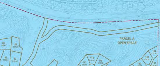
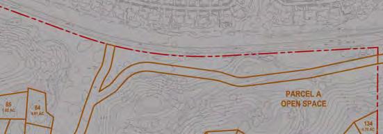
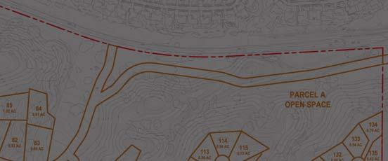
3 Critical viewshed Areas of Visual Sensitivity 100-Foot Setback T:\_CS\Work\Monterey, County of\ferrini Ranch \Figures\Section 3-1 Source: Monterey County RMA NOT TO SCALE FIGURE 3.1-1A VISUAL SENSITIVITY & CRITICAL VIEWSHEDS WESTERN PARCEL
4 This page intentionally left blank. Draft Environmental Impact Report August


5 Critical viewshed Areas of Visual Sensitivity 100-Foot Setback T:\_CS\Work\Monterey, County of\ferrini Ranch \Figures\Section 3-1 Source: Monterey County RMA NOT TO SCALE FIGURE 3.1-1B VISUAL SENSITIVITY & CRITICAL VIEWSHEDS EASTERN PARCEL
6 This page intentionally left blank. Draft Environmental Impact Report August
7 River Road River Road, one of the three primary access roads to the project site, is a two-lane roadway along the western portion of the Salinas Valley and the Salinas River, becoming a four-lane roadway adjacent to the project site near its junction with State Route 68. This road is also the primary roadway accessing the developing winery corridor of Monterey County to the south. River Road will provide access to Lots #138 through #144 and the agricultural industrial uses on Parcel D. Views from the River Road/State Route 68 intersection and the River Road corridor are of the Sierra de Salinas foothills to the west and of row crops to the east. These features are included among the most visually sensitive features of the Toro Planning Area. Due to the existing topography immediately adjacent to River Road, views into the property are mostly obscured by steep hillsides. Parklands The western parcel and eastern parcel of the project site are separated by a section of Toro County Park. Additionally, the Bureau of Land Management owns public land on the northern side of State Route 68 on former Fort Ord lands. These lands provide mountain biking, hiking, and horseback riding opportunities to the public. Views of the subject property, Salinas Valley, the Coastal Range, and Monterey Bay are currently available from these park and public lands, as described further below. Toro County Park The Monterey County Parks Department owns and operates the 4,789-acre Toro County Park located along State Route 68 and adjacent to the project site. Toro County Park includes 17 miles of hiking, mountain biking, and equestrian trails; a camping area accommodating approximately 100 people; a nature center; and day-use picnic areas. An equestrian staging area and horse rental facility are also located within the park. The more centralized picnic and day-use recreation facilities concentrated along the park s valley floor are more frequently used than the trails, camping areas, equestrian facilities and nature center. Approximately 120,000 people visit the park annually with peak attendance concentrated during holiday weekends special events. Bureau of Land Management Public Land The Bureau of Land Management (BLM) owns approximately 7,200 acres of public land on the former Fort Ord, located on the northern side of State Route 68. This public land includes 50 miles of trails and is open daily from dawn to dusk. Approximately 75,000 people visit the BLM land annually. A majority of the visitors are mountain bikers, followed by hikers and horseback riders. The most popular hiking and horseback riding areas are near Toro Estates and Portola Road adjacent to State Route 68, where there is an informal dirt parking area and equestrian staging area. Approximately 70 percent of those using the park visit the eastern/southeastern portion of the property. August Draft Environmental Impact Report
8 LIGHT AND GLARE The project area is rural in character; therefore, sources of light and glare are limited. Rural residential development along State Route 68 and in the Salinas Valley to the northeast creates background light and glare in the project area, as well as ambient nighttime glow. Foreground light and glare are created by street lighting and by vehicles traveling along the roadways abutting the site REGULATORY SETTING CALIFORNIA SCENIC HIGHWAY PROGRAM California's Scenic Highway Program was created by the State Legislature in The primary purpose of the program is preservation and protection of scenic highway corridors from change that could diminish the aesthetic value of lands adjacent to highways. The state laws governing the Scenic Highway Program are in the Streets and Highways Code, Section 260 et seq. California identifies portions of the state highway system and adjacent scenic corridors as areas that require special scenic conservation treatment per Sections 260 and 262 of the California Code of Regulations. The California Department of Transportation (Caltrans) is the responsible agency for determining whether or not proposed scenic highways satisfy the criteria for being a scenic highway. Once designated, the local governing body must adopt a program to protect the scenic corridor, and zoning and land use along the highway must meet the State's legislatively required elements for scenic highway corridor protection. State Route 68 is a designated California scenic highway. COUNTY OF MONTEREY Monterey County General Plan Slopes Greater than 30 Percent The County shall prohibit development on slopes greater than 30 percent. It is the general policy of the County to require dedication of scenic easement on a slope of 30 percent or greater. Upon application, an exception to allow development on slopes of 30 percent or greater may be granted at a noticed public hearing by the approving authority for discretionary permits or by the Planning Commission for building and grading permits. The exception may be granted if one or both of the following findings are made, based upon substantial evidence: A) There is no alternative which would allow development to occur on slopes of less than 30 percent; or Draft Environmental Impact Report August
9 B) The proposed development better achieves the resource protection objectives and policies contained in the Monterey County General Plan, accompanying Area Plans and Land Use Plans, and all applicable master plans. Ridgeline Development Policy Restricting development on ridgelines serves County goals of protecting its scenic and rural character. The Monterey County General Plan defines ridgeline development as development on the crest of a hill which has the potential to create a silhouette or other substantially adverse impact when viewed from a common public viewing area. Policies have been developed to avoid development on all ridgelines visible from public viewpoints within the county, unless a special permit is granted In order to preserve the County s scenic and rural character, ridgeline development will not be allowed unless a special permit is first obtained. Such a permit shall only be granted upon findings being made that the development, as conditioned by permit, will not create a substantially adverse visual impact when viewed from a common public viewing area. New subdivisions shall avoid lot configurations, which create building sites that will constitute ridgeline development. Siting of new development visible from private viewing areas may be taken into consideration during the subdivision process. Light and Glare Policy All exterior lighting shall be unobtrusive and constructed or located so that only the intended area is illuminated, long range visibility is reduced, and off-site glare is fully controlled. Scenic Highway Policies The County s Scenic Highway System is composed of roads and highways that have been designated by the state as state scenic highways or county scenic routes. Relevant County policies for protecting and enhancing these scenic roadways include: Additional sensitive treatment provisions shall be employed within the scenic corridor, including placement of utilities underground, where feasible; architectural and landscape controls; outdoor advertising restrictions; encouragement of area native plants, especially on public lands and dedicated open spaces; and cooperative landscape programs with adjoining public and private open space lands Land use controls shall be applied or retained to protect the scenic corridor and to encourage sensitive selection of sites and open space preservation. Where land is designated for development at a density that would diminish August Draft Environmental Impact Report
10 scenic quality, should maximum permissible development occur, the landowner shall be encouraged to voluntarily dedicate a scenic easement to protect the scenic corridor Land use, architectural, and landscaping controls shall be applied and sensitive site designing encouraged to preserve Toro s scenic entrances the River Road/State Route 68 intersection and the Laureles Grade scenic vista overlooking the Planning area. Toro Area Plan According to Figure 9, Visual Sensitivity and Scenic Highway, in the Toro Area Plan, portions of the project site is located within an area of visual sensitivity. Visual Sensitivity Policies The preservation of oak trees in the Toro area shall be promoted by discouraging removal of healthy trees with diameters in excess of eight inches Within areas of visual sensitivity as indicated on the Toro Visual Sensitivity Map, no development shall be permitted without a finding by the Board of Supervisors or its designee that such development will not adversely affect the natural scenic beauty of the area. Additionally, areas of visual sensitivity shall be reviewed critically for landscaping and building design and siting which will enhance the scenic value of the area The County shall encourage in the Toro area, the use of optional design and improvement standards as described in Article VI of Title 19 of the Monterey County Code In order to preserve open space, clustered development or alternate techniques may be found appropriate in all areas where development is permitted, subject to environmental and health standards and limitations The County shall require a 100 foot building setback on all parcels adjacent to County and State scenic routes. The 100 foot setback will also apply to areas designated on the Toro Visual Sensitivity map (Toro Area Plan, Figure 9) as critical viewshed. This setback is established without causing existing structure to become nonconforming and without rendering existing lots of record unbuildable. Critical viewshed area shall also have open space zoning applied to the 100 foot setback area The County shall require newly created parcels to have building sites outside of the critical viewshed. Draft Environmental Impact Report August
11 Density transfer shall be allowed from the acreage within the critical viewshed to other contiguous portions of the same ownership, but must meet all other area and general plan policies Where Plan policies would prohibit any development on a parcel, the density allowed by the land use designation shall be permitted in the critical viewshed. Ridgeline Development Policy Development on ridgelines and hilltops or development protruding above ridgelines shall be prohibited. Additionally, only minimal development on steeper and critical viewshed slopes shall be allowed. Light and Glare Policy Lighting of outdoor areas shall be minimized and carefully controlled to preserve the quality of darkness. Street lighting shall be as unobtrusive as practicable and shall be consistent in intensity throughout the Toro area. Monterey County Zoning Code Design Control Zoning District The purpose of Chapter of the Monterey County Zoning Ordinance is to provide a district for the regulation of the location, size, configuration, materials, and colors of structures and fences, except agricultural fences, in those areas of the County of Monterey where the design review of structures is appropriate to assure protection of the public viewshed, neighborhood character, and to assure the visual integrity of certain developments without imposing undue restrictions on private property. Design Control (D) districts designate areas of the county that require protection of the public viewshed and neighborhood character, and to assure the visual integrity of development without imposing undue restrictions on private property. This designation regulates the location, size, configuration, materials, and colors of structures and fences through a design approval process. Two parcels on the project site, Assessor s Parcel Numbers (APN) and located at the corner of State Route 68 and San Benancio Road (proposed Lots #1 through #65) and near the entrance of Toro County Park (proposed Parcel E clustered units), respectively, are zoned within a Design Control district. A design approval application must be submitted and approved prior to the issuance of the building permits for the construction of any structures in the D district pursuant to Section of the Monterey County Zoning Ordinance. Monterey County is required to review architectural projects to confirm compatibility of the development with the surrounding character of the land. Development in a highly August Draft Environmental Impact Report
12 sensitive area must minimize its impact on the viewshed. If compelling circumstances are demonstrated, exceptions to the above requirements may be considered. Site Plan Review Zoning District The purpose of Chapter of the Monterey County Zoning Ordinance is to provide district regulations for review of development in those areas of the County of Monterey where development, by reason of its location has the potential to adversely affect or be adversely affected by natural resources or site constraints without imposing undue restrictions on private property. One parcel on the project site, APN , located at the corner of State Route 68 and San Benancio Road (proposed Lots #1 through #65), is zoned within a Site Plan Review (S) district. A Site Plan Approval Application must be submitted and approved prior to the issuance of permits for the construction of any development in the S district pursuant to Section of the Monterey County Zoning Ordinance. All districts which are combined with the S district are subject to the provisions of Chapter of the County of Monterey Zoning Ordinance, which establishes height and setback exceptions. Visual Sensitivity Zoning District The purpose of Chapter of the Monterey County Zoning Ordinance is to provide district regulations for the review of development in those areas of the County of Monterey in which such development could potentially create adverse visual impacts when viewed from a common public viewing area. Development within a Visual Sensitivity (VS) district requires approval of a Use Permit or an Administrative Permit and a design that is in accordance with the development standards provided in Section of the Monterey County Zoning Ordinance. One parcel on the project site, APN , located near the entrance of Toro County Park (proposed Parcel E clustered units), is zoned within a Visual Sensitivity district. According to Section of the Monterey County Zoning Ordinance, development standards for all development and subdivisions in the VS combining district include the following: Flagging and staking of any portion of the project that may have the potential to create a substantially adverse visual impact; Lot configurations to provide optimum screening by existing or proposed topography and vegetation; Building sites and new access road locations to be screened by existing or proposed topography and vegetation; Structures and access roads sited to minimize grading, tree removal, viewing from public areas and development on slopes greater than 30 percent; Draft Environmental Impact Report August
13 Structures shall be clustered keeping wooded hills and ridges placed in open space or scenic easement; and New utility and transmission lines shall be placed underground. All districts which are combined with the VS district are subject to the provisions of Chapter of the Monterey County Zoning Ordinance, which establishes height and setback exceptions. Regulations for Development on Slopes Greater Than 30 Percent The purpose of Section of the Monterey County Zoning Ordinance is to establish regulations, procedures and standards to consider development on slopes in excess of 30 percent. Section C.1 identifies requirements of development on slopes in excess of 30 percent, which include: 1. A Use Permit is required for all development on slopes of 30 percent or more, except as provided in Section (C) (2) and (3). 2. An Administrative Permit is required for the following development on slopes of 30 to 40 percent: a. Soils tests, percolation tests, geologic tests and similar exploratory tests; b. Excavations on man-made slopes provided: i. The excavation does not exceed 100 cubic yards; and ii. The excavation does not exceed 2 feet in depth; and iii. The excavated slopes are not steeper than the 1½ horizontal to 1 vertical; c. Fills on man-made slopes provided: i. The fill contains earth material only; and ii. The fill does not exceed 100 cubic yards; and iii. The fill does not exceed 2 feet in depth; and iv. The fill is not placed on a man-made slope in excess of 1½ horizontal to 1 vertical. d) Additions to existing structures on natural or man-made slopes provided the addition does not exceed 120 square feet on the slope area. 3. Internal remodeling and second story additions of portions of structures existing on slopes of 30 percent or more are exempt from Use Permits and Administrative August Draft Environmental Impact Report
14 Permits provided such remodeling or additions causes no site disturbance on slopes of 30 percent or more. In order to approve development on slopes of 30 percent of more, the appropriate authority must find that there is no feasible alternative which would allow development to occur on slopes of less than 30 percent slopes or that the proposed development better achieves the goals, policies, and objectives of the Monterey County General Plan and applicable area plan than other development alternatives. Ridgeline Development The purpose of Section of the Monterey County Zoning Ordinance is to provide standards for those projects which constitute ridgeline development. A Use Permit for ridgeline development may be approved only if the ridgeline development, as conditioned by permit, will not create a substantially adverse visual impact when viewed from a common public viewing area IMPACTS AND MITIGATION MEASURES METHODOLOGY Available information pertaining to aesthetics and visual sensitivity within the project site was reviewed during this analysis, including but not limited to, Monterey County General Plan (Monterey County 1982), Toro Area Plan (Monterey County 1983), and Monterey County Zoning Ordinance (Monterey County 2000). Analysis of potential aesthetic impacts is based upon field review of the project site and surrounding areas, photographs of visual vantage points on and in the vicinity of the project site, a review of Monterey County s plans and policies, and preparation of visual simulations of the post-project environment. Critical viewshed and visual sensitivity maps (Figures 3.1-1a and 3.1-1b) were provided by Monterey County. The approach adapted for this visual assessment uses static visual simulations as described below. Resource Evaluation Perception of Landscape Quality and Change Aesthetic resources are identified through the visual features or resources of the landscape, the character and quality of those resources relative to overall regional visual character, and the sensitivity of views of visual resources. With the preliminary baseline (existing) condition established, changes to the landscape by a proposed project are then systematically evaluated for the degree of impact. The degree of impact depends on both the magnitude of change in the visual character and quality and viewers responses to and concern for those changes. The three criteria below can be used to assess the visual character and quality for most visual assessments: Draft Environmental Impact Report August
15 Vividness is the visual power or memorability of landscape components as they combine in striking or distinctive visual patterns. Intactness is the visual integrity of the natural and human-built landscape and its freedom from encroaching elements; this factor can be present in well-kept urban and rural landscapes, as well as in natural settings. Unity is the visual coherence and compositional harmony of the landscape considered as a whole; it frequently attests to the careful design of individual components in the landscape. Viewer Sensitivity Viewer sensitivity is based on the visibility of resources in the landscape, the proximity of viewers to visual resources, the elevation of viewers relative to visual resources, the frequency and duration of views, the number of viewers, and the viewers expectations. One factor in identifying the importance of views is the position of the viewer relative to the resource. An area of the landscape that is visible from a particular location (e.g., an overlook) or series of points (e.g., a road or trail) is defined as a viewshed. To identify the importance of views as resources, a viewshed may be broken into distance zones of foreground (0.25 to 0.5 miles from viewer), middle ground (3 to 5 miles from viewer), and background (more than 5 miles from viewer). Resources that are higher in elevation than the viewer generally tend to take on greater visual importance than resources located at a lower elevation than the viewer. Visual sensitivity also depends on the number and type of viewer, and the frequency and duration of views. Generally, visual sensitivity increases with the number of viewers, the frequency of viewing (e.g., daily or seasonally), and the duration of views (i.e., how long a scene is viewed). For example, visual sensitivity can be greater for people who are driving for pleasure than for those commuting to work. High quality views from recreation trails and areas, scenic highways, and scenic overlooks are generally considered visually sensitive. Visual Simulations Static visual simulations are prepared by compositing site photographs with project images generated by a computer topographic modeling program, or other means, in a geographically accurate manner. Photos are taken at eye height, using an industry standard angle of view that approximates the 45-degree human eye view angle. For this simulation, roadways and generic residences are modeled. Grading, landscaping, and street lighting have not been modeled by the EIR consultant, as project plans typically do not include this degree of detail. The EIR simulations also present individual homes in a stark, contrasting white, whereas the actual built environment is expected to blend more with the landscape. The simulations are therefore considered a worst-case or unmitigated representation. August Draft Environmental Impact Report
16 Data Collection Data for the topographic model was obtained from several sources. A digital elevation model (DEM) was the basis of the project site and the surrounding topography model. Aerial imagery of the project site was also incorporated. The project tentative map provided information for lot lines and road rights-of-way. The Monterey County Public Works Department provided right-of-way information for State Route 68 and nearby roadways. The Monterey County Regional Parks Department provided boundary information for Toro County Park. Data was supplied in both computer-aided design (CAD) and geographic information systems (GIS) formats. Accuracy was ensured by georeferencing the information in a GIS environment. Viewshed Analysis A viewshed analysis was performed using GIS to determine the appropriate locations from which to take photographs of the existing conditions of the project site. This was accomplished by compiling relevant site information, including lot lines, maximum building height, and topography, in a GIS application. The results identified the locations where the most proposed development would be visible from a single viewpoint. Camera locations were identified with the Monterey County Planning Department based upon the convergence of these locations and public common viewing areas such as State Route 68, River Road, and popular trails within Toro County Park and BLM public land. Several of the viewpoint locations were adjusted to avoid the intrusion of vegetation, buildings, and other obstructions into the photographs. Viewpoint locations were recorded with a global positioning system (GPS) at the time the photographs were taken to ensure accurate verification and placement within the computer model. Photographs were taken using a camera equipped with a fixed-focal length lens to best approximate the human eye s field of vision and to create an image that could be accurately replicated by the modeling application. Model Construction Project modeling began by compiling all relevant data, including the proposed lot lines, road rights-of-way, the camera viewpoints, the DEM, and the aerial imagery, in a GIS application. The DEM was then converted to a triangulated irregular network (TIN) for use in the modeling application. The data was exported from the GIS application to the modeling application. The TIN, proposed site development data, and camera viewpoint locations were jointly exported to ensure the preservation of accurate spatial relationships within the modeling application. The lot lines and road right-of-way lines were draped onto the TIN, demarcating the road rights-of-way with an asphalt appearance, and placing lots in the appropriate locations on the TIN. Since no final design plans were available at the time of preparation, a generic residential model, constructed to the maximum building height allowed by the Monterey County Zoning Code, was used to expedite the modeling process. The proposed wine Draft Environmental Impact Report August
17 tasting facility has not been modeled as information pertaining to the building dimensions or building site location on Parcel D is not available. The aerial imagery was then draped onto the TIN for reference during the creation of the visual simulations. Creation of Visual Simulations Camera views of the model were taken to match the existing conditions photographs. This was achieved by placing virtual cameras at the viewpoint locations within the modeling program indicated by the GPS data and adjusting the cameras orientations to match the views displayed in the photographs. Accuracy was ensured by matching the virtual cameras specifications to the camera used in the field. This effort resulted in two sets of images. One set was specifically created for use in the visual simulations and includes only the proposed development intended for display in the completed visual simulations. An additional set, including the TIN, was also prepared for reference during the production of the visual simulations. Visual simulations were created by compositing a virtual camera view of the model with the corresponding existing conditions photograph. This involved combining the two images and accurately placing the proposed development in relationship to topography, vegetation, other buildings, and other built features (i.e., fences, telephone poles, etc.). Accuracy was ensured by determining the arrangement of these elements in the existing condition photographs and reviewing the location of proposed houses and road rights-ofway relative to topography and items appearing on the aerial imagery in the model. The road rights-of-way were also edited to properly convey the width of the proposed roads, but not the final grading of the roadways. The completed visual simulations were reviewed to ascertain which proposed lots are visible from the selected viewpoints. This involved using the modeling application to determine what lots appear in each camera viewpoint and referencing them with the numbered lots on the proposed tentative map. All viewpoints and analysis results are shown in the Project Impacts and Mitigation Measures section of this chapter. Applicant s Simulations The end of this section also includes visual images and simulations prepared by the project applicant s engineer, taken from similar viewpoints used by the EIR consultant. The applicant s images have been reviewed and compared to the EIR consultant s images and included as additional information for this analysis. The primary difference between the two sets of simulations is the applicant s inclusion of grading and landscape screening, based on more detailed grading information and more extensive rendering of the images. The applicant has also supplied a line of sight analysis and visual cross sections for Parcel D for County review. With this additional rendering and detail, these images are more representative of the mitigated project condition. August Draft Environmental Impact Report
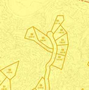
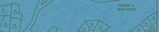
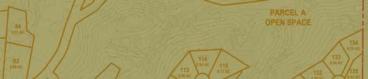
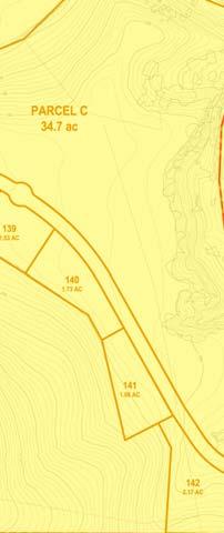
18 STANDARDS OF SIGNIFICANCE The following thresholds for measuring a project s environmental impacts are based on CEQA Guidelines and standards used by the County of Monterey. For the purposes of this DEIR, impacts are considered significant if the following could result from implementation of the proposed project: 1) Result in visually prominent development in critical viewsheds or areas of visual sensitivity inconsistent with County policies and resource maps. 2) Have an adverse negative effect on a scenic view or vista. 3) Damage individual or iconic scenic resources, including but not limited to, trees, rock outcroppings, and historic buildings within the project site or within a state scenic highway. 4) Degrade the existing visual character or quality of the site and its surroundings as experienced by the viewer. 5) Create new source of light or glare, which would adversely affect day or nighttime views in the area. PROJECT IMPACTS AND MITIGATION MEASURES Development Within Critical Viewsheds and Areas of Visual Sensitivity Impact Implementation of the project will result in the creation of residential lots and construction of homes and roadway improvements in areas designated as critical viewshed and areas of visual sensitivity, as defined by Monterey County resources maps and the Toro Area Plan. Development within visually sensitive areas is a potentially significant impact of the project. Critical Viewsheds The project s tentative map proposes development within portions of the critical viewshed (see Figures 3.1-1a and 3.1-1b). Specifically, Lot #75, Lots #81 through #85, Lot #143, Lot #144, Ferrini Ranch Road (main project access road), and the River Road access are all located within the critical viewshed. The Monterey County General Plan and Toro Area Plan contain policies that restrict and regulate development in such areas. The visual sensitivity policies of the Toro Area Plan are the most specific and restrictive. Toro Area Plan policies do not necessarily prohibit development within the areas of visual sensitivity. However, the policies do require that newly created parcels have building sites outside of the critical viewshed area and require a 100-foot building setback from scenic routes. Consistent with Policy (T) of the Draft Environmental Impact Report August
19 Toro Area Plan, critical viewshed areas, including the 100-foot setbacks, shall have open space zoning applied. Critical viewsheds, areas of visual sensitivity, and 100-foot setbacks are shown in Figures 3.1-1a and 3.1-1b. Avoiding the critical viewshed and 100-foot setbacks may be possible on Lots #13, #14, #75, #81, #85, #142, and #146 and Parcel E through building envelope placement and placement of easements on lots. However, Lots #1, #2, #10 through #12, #82 through #85, and #144 are either mostly and/or fully contained within either the critical viewshed boundary or 100-setback area; therefore, the building envelopes cannot be relocated without relocating entire lots. Similarly, the River Road access point and the portion of Ferrini Ranch Road adjacent to State Route 68 are permanent project features within the critical viewshed that have limited flexibility in terms of location. The River Road access is a single access point, similar to other existing property access locations within the critical viewshed. Ferrini Ranch Road, however, is a more significant linear feature parallel to Highway 68, with potentially greater impacts. Whereas other projects over time have constructed roads and/or access points along Highway 68 within the critical viewshed without causing significant impacts, the Ferrini Ranch Road access through Toro Park has unique characteristics in terms of length and location that justify the finding of significance. Areas of Visual Sensitivity The project site and tentative map contain large areas designated on Monterey County resource maps as areas of visual sensitivity. As demonstrated in Figures 3.1-1a and 3.1-1b, dozens of lots and other improvements are either fully or partially located within this designation, as is all of Parcel D (winery/visitor center) and surrounding lots. According to the Toro Area Plan, visually sensitive areas require responsible management for their character to be retained, but development is not necessarily prohibited. The proposed project consists of developing residential lots and related roads and infrastructure on the south side of State Route 68, which is identified in the Toro Area Plan as an area of visual sensitivity. The County of Monterey has established development standards for land uses within scenic areas. These development standards are implemented through the use of zoning and design review requirements. Three of the nine existing parcels on the project site (APNs , , and ) are currently zoned with different Design Control zoning overlays. The County intends to reclassify the entire project site with LDR/2.5-VS-D zoning consistent with the General Plan Land Use Map as part of the 2010 General Plan Implementation. Therefore, all development would ultimately be subject to requirements and standards of Chapters and of the Monterey County Zoning Code which defines regulations for those areas within D and VS overlays, respectively. August Draft Environmental Impact Report
20 Design Control zoning districts regulate the location, size, configuration, materials, and colors of structures and fences through a design approval process. Visual Sensitivity zoning districts designate areas of the county that require protection of common public viewing areas. Development within a Visual Sensitivity district requires approval of a Use Permit and a design that is in accordance with the development standards provided in Section of the Monterey County Zoning Ordinance. In addition, Policy of the Toro Area Plan states that no development within areas of visual sensitivity shall be permitted without a finding by the Board of Supervisors or its designee that such development will not adversely affect the natural scenic beauty of the area. Additionally, areas of visual sensitivity shall be reviewed critically for landscaping and building design and siting which will enhance the scenic value of the area. Policy is applicable to portions of the project site. Compliance with these existing development standards and design review provisions of the D and VS zoning districts as defined by Chapters and the Monterey County Zoning Code, respectively, as well as applicable policies of the Monterey County General Plan and Toro Area Plan, will adequately address most aesthetic and visual impact issues in areas of visual sensitivity. Development standards for all lots and improvements within the subdivision would require the following: Flagging and staking of any portion of the project that may have the potential to create a substantially adverse visual impact or be visible from public viewing areas (including Monterey County Planning Department review and consideration of flagging and staking in the field); Building sites and new access road locations are to be sited in a way that development is screened by existing or proposed topography and vegetation, minimizes grading, erosion, and tree removal, on slopes less than 30 percent, clustered, and minimizes visibility from common public viewing areas; New utility and transmission lines shall be placed underground; and Implementation of review process and regulation of the location, size, configuration, materials, and colors of structures and fences, except agricultural fences. In addition, compliance with Section b.5 of the Monterey County Zoning Code requires erosion control plans that include revegetation of all surfaces exposed or expected to be exposed during development activities, including cut and fill slopes. Compliance with the regulations of the VS zoning district and erosion control plan (as required under mitigation measure MM 3.5-5a), together with implementation of all other visual regulations as contained in the Monterey County Zoning Code, would adequately mitigate impacts to areas of visual sensitivity. However, development activity is proposed to occur within the critical viewshed and related 100-foot setbacks. If additional measures beyond the D and VS zoning development standards were not in place, future development could result in significant adverse effects to resources within and near critical viewsheds, which would be considered Draft Environmental Impact Report August
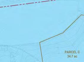
21 a potentially significant impact. Implementation of the following mitigation measures would ensure that potential impacts are avoided or reduced to the extent feasible. Mitigation Measures MM 3.1-1a MM 3.1-1b MM 3.1-1c Prior to final map approval, the project applicant shall reconfigure the lot and development pattern to relocate building sites for residential lots outside of the critical viewshed areas and 100-foot scenic roadway setback. Buildings on lots where building sites cannot be fully located outside the critical viewshed must not be visible from scenic roadways (SR 68, River Road, or San Benancio Road). Prior to final map approval, the project applicant shall identify all open space parcels (Parcels A, B, and C) as scenic and conservation easements, subject to specific uses and conditions as defined by the Monterey County Planning Department. Easements shall be recorded in deed and title upon final map approval. In addition to all provisions and development restrictions set forth by Monterey County for scenic and conservation easements, final maps and recorded easements shall also include specific requirements and allowances for easement maintenance and rural fire protection, continued grazing and grazing operations, protection of habitat and sensitive resource areas specifically set aside as mitigation, fencing and public access, and provision and maintenance of necessary infrastructure improvements (trails, drainage facilities, detention basins, and similar). Upon final map approval, the Monterey County Planning Department shall apply a B-6 overlay to the entire property and proposed subdivision. Implementation of the B-6 overlay would prohibit future subdivision of the project site. Development within these restricted areas is subject to a Use Permit (Monterey County Zoning Code Sections and ) and the development standards identified in Section of the Monterey County Zoning Code, as well as the design review and site plan review process. In addition to the standards and requirements of Chapters and of the Monterey County Zoning Code, future development proposed on these lots shall be subject to review and approval as to the proposed building site location, topography, existing vegetation, proposed landscaping, proposed parking layout, proposed grading, and any identified environmentally sensitive habitats and hazards. This review may result in relocation and reduction of proposed building envelopes in order to assure protection of the public viewshed and neighborhood character, and to assure the visual integrity of certain developments and to avoid natural resources that are important components of these visually sensitive areas. Compliance with these existing zoning requirements will screen and visually mitigate proposed development to the extent required and afforded by the County s zoning district overlays that address the most visually sensitive areas. Any modifications to site plans or improvement plans shall be August Draft Environmental Impact Report
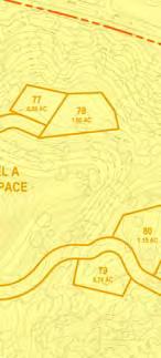
22 submitted to the Monterey County Planning Department for review and approval prior to recordation of final maps. Although the above mitigation measures and existing zoning requirements will serve to reduce impacts to areas to visual sensitivity and critical viewsheds to the greatest degree possible, development of the project will require construction of improvements (i.e., roadways) within the critical viewshed and 100-foot setback that cannot be fully mitigated or avoided consistent with County visual protection policies for newly created parcels. Residential development (structures) in critical viewshed and visually sensitive areas can be fully mitigated through a combination of mitigation measures and existing zoning requirements. However, roadway improvements for the Ferrini Ranch Road access through Toro Park within the 100-foot setback would remain significant and unavoidable unless the main access road were to be relocated through design changes or through selection of an alternative. Effects on Scenic Views or Vistas Impact Implementation of the proposed project would result in permanent alteration of site conditions that may be viewed from Laureles Grade Road, BLM Lands (Fort Ord Public Lands), and Toro County Park. This would be considered a less than significant impact of the project. To assist with this portion of the visual analysis, the following pages contain a Viewpoints Map (Figure 3.1-2) and corresponding photographs and visual simulations of the project (Figures through ). These images are referenced throughout this analysis section to assess visual changes that may occur at the project site. Vistas from Laureles Grade Areas of the western portion of the project site will be visible from Laureles Grade, a public viewing area and locally designated scenic road. However, at a viewing distance of approximately 3 miles, visual impacts from development of residential lots and site improvements are anticipated to be minimal and inconsequential, with low viewer sensitivity. The views from Laureles Grade do not constitute a significant vista toward the project site. All lots potentially visible from this location will also be subject to the design and siting controls of the D and S zoning overlay districts, which will further limit visual impacts. Impacts to views and vistas as seen from Laureles Grade will therefore be less than significant. Vistas from BLM Public Land (Viewpoints #8 and #9) Based on the visual simulations, proposed development on Lots #45 through #47, Lots #60, #62, #63, #66, #70, #71, #77, #78, Lots #86 through #89, Lots #94, #95, #100, #101, Lots #104 through #115, Lots #117, #119, Lots #124 through #133, and Lot #137 may be visible from BLM public land at Viewpoints #8 and #9 when viewed to the south, as shown in Figures and Most of the visible area of the project would be considered to be in the foreground and mid-ground due to the relatively short distance (about 0.5 mile) from the viewing area. Views from this vantage point are from higher Draft Environmental Impact Report August
23 T:\_GIS\MONTEREY_COUNTY\MXDS\FERINNI RANCH\FIG VIEWPOINTS.MXD - 1:00:44 PM 1 Bureau of Land Management (BLM) Public Land 8 9 Agriculture San Benancio Middle School The Oaks Development (Single Family Residences) Project Site Western Parcel Toro Estates Development Toro County Park Parcel E Parcel B Project Site Eastern Parcel Parcel D Agriculture Las Palmas Development Proposed Harper Cayon (Encina Hills) Development (Single Family Residences) Source: Aerial: USDA FSA NAIP, 2005; Monterey County GIS Dept., 2007; PMC, FEET Legend Viewpoint View Direction Project Boundary FIGURE VIEWPOINTS MAP
24 This page intentionally left blank. Draft Environmental Impact Report August


25 T:\_CS\Work\Monterey, County of\ferrini Ranch \Figures\Section 3-1 Figure 3.1-3a. Existing conditions as viewed from eastbound State Route 68 near San Benancio Road looking east towards Lots #13 through #15. Figure 3.1-3b. Visual simulations as viewed fromeastbound State Route 68 near San Benancio Road looking east towards Lots #13 through #15. FIGURE VIEWPOINT #1 EXISTING CONDITIONS AND VISUAL SIMULATIONS
26 This page intentionally left blank. Draft Environmental Impact Report August


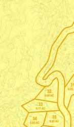
27 T:\_CS\Work\Monterey, County of\ferrini Ranch \Figures\Section 3-1 Figure 3.1-4a. Existing conditions as viewed from State Route 68 looking south towards Lots #20 through #22 and Lots #24 through #28. Figure 3.1-4b. Visual simulations as viewed from State Route 68 looking south towards Lots #20 through #22 and Lots #24 through #28. FIGURE VIEWPOINT #2 EXISTING CONDITIONS AND VISUAL SIMULATIONS
28 This page intentionally left blank. Draft Environmental Impact Report August


29 T:\_CS\Work\Monterey, County of\ferrini Ranch \Figures\Section 3-1 Figure 3.1-5a. Existing conditions as viewed from State Route 68 looking southeast towards Lot #76. Figure 3.1-5b. Visual simulations as viewed from State Route 68 looking southeast towards Lot #76. FIGURE VIEWPOINT #3 EXISTING CONDITIONS AND VISUAL SIMULATIONS
30 This page intentionally left blank. Draft Environmental Impact Report August

31 T:\_CS\Work\Monterey, County of\ferrini Ranch \Figures\Section 3-1 Figure 3.1-6a. Existing conditions as viewed from State Route 68 looking east towards Lots #133 through #135. Figure 3.1-6b. Visual simulations as viewed from State Route 68 looking east towards Lots #133 through #135. FIGURE VIEWPOINT #4 EXISTING CONDITIONS AND VISUAL SIMULATIONS
32 This page intentionally left blank. Draft Environmental Impact Report August
. Figure 3.1-7b.")
33 T:\_CS\Work\Monterey, County of\ferrini Ranch \Figures\Section 3-1 Figure 3.1-7a. Existing conditions as viewed from westbound State Route 68 looking southwest towards Lots #138 through #140 and Parcel D (wine tasting facility). Figure 3.1-7b. Visual simulations as viewed from westbound State Route 68 looking southwest towards Lots #138 through #140 and Parcel D (wine tasting facility). FIGURE VIEWPOINT #5 EXISTING CONDITIONS AND VISUAL SIMULATIONS
34 This page intentionally left blank. Draft Environmental Impact Report August
. Figure 3.1-8b.")
35 T:\_CS\Work\Monterey, County of\ferrini Ranch \Figures\Section 3-1 Figure 3.1-8a. Existing conditions as viewed from northbound River Road looking northwest towards Parcel D (wine tasting facility). Figure 3.1-8b. Visual simulations as viewed from northbound River Road looking northwest towards Parcel D (wine tasting facility). FIGURE VIEWPOINT #6 EXISTING CONDITIONS AND VISUAL SIMULATIONS
36 This page intentionally left blank. Draft Environmental Impact Report August

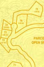
37 T:\_CS\Work\Monterey, County of\ferrini Ranch \Figures\Section 3-1 Figure 3.1-9a. Existing conditions as viewed from Toro Regional Park looking northwest towards Lots #47, #52, #53, #65, #66, #70, #71, #88, #90, #97, Lots #99 through #102, Lots #108, #109, #112, #116, and Lots #120 through #127. Figure 3.1-9b. Visual simulations as viewed from Toro County Park looking northwest towards Lots #47, #52, #53, #65, #66, #70, #71, #88, #90, #97, Lots #99 through #102, Lots #108, #109, #112, #116, and Lots #120 through #127. FIGURE VIEWPOINT #7 EXISTING CONDITIONS AND VISUAL SIMULATIONS
38 This page intentionally left blank. Draft Environmental Impact Report August


39 T:\_CS\Work\Monterey, County of\ferrini Ranch \Figures\Section 3-1 Figure a. Existing conditions as viewed from BLM public land looking south towards Lots #45 through #47, Lots #60, #62, #63, #66, #70, #71, #77 and #78. Figure b. Visual simulations as viewed from BLM public land looking south towards Lots #45 through #47, Lots #60, #62, #63, #66, #70, #71, #77 and #78. FIGURE VIEWPOINT #8 EXISTING CONDITIONS AND VISUAL SIMULATIONS
40 This page intentionally left blank. Draft Environmental Impact Report August


41 T:\_CS\Work\Monterey, County of\ferrini Ranch \Figures\Section 3-1 Figure a. Existing conditions as viewed from BLM public land looking south towards Lots #86 through #89, Lots #94, #95, #100, #101, Lots #104 through #115, Lots #117, #119, Lots #124 through #133, and Lot #137. Figure b. Visual simulations as viewed from BLM public land looking south towards Lots #86 through #89, Lots #94, #95, #100, #101, Lots #104 through #115, Lots #117, #119, Lots #124 through #133, and Lot #137. FIGURE VIEWPOINT #9 EXISTING CONDITIONS AND VISUAL SIMULATIONS
42 This page intentionally left blank. Draft Environmental Impact Report August
43 elevations, looking downward toward the site, with distant (background) views of hills and ridgelines behind. Given that BLM locations are used for trail hiking and active outdoor recreation, viewer sensitivity from these public viewing locations is considered high. However, given the physical challenges of accessing the higher BLM trails, with no designated vista point, the BLM trails are not considered by the County to be common public viewing areas as defined by Title 21. Lots #1 through #65 are subject to Chapters and of the Monterey County Zoning Ordinance, which regulate the location, size, configuration, materials, and colors of structures and fences through a design approval process and ensure that the scenic quality of the project site and vicinity is not diminished. With application of these existing regulations, and considering the fact that the BLM trail areas are no considered common public viewing areas, visual impacts as experienced from these viewpoints and vistas are considered less than significant. All individual lots and homesites are required to demonstrate compliance with applicable development standards and conditions through the design review process. Although Lots #66 through #144 may not be specifically designated within a D (Design Control), S (Site Plan Review), or VS (Visually Sensitive) zoning district, the County intends to apply these overlays to the entire project site. Furthermore, Policy of the Monterey County General Plan provides specific development standards for visually sensitive areas including, but not limited to, requiring flagging and staking, screening with topography and/or vegetation, clustering development, and underground utilities. Vistas from Toro County Park (Viewpoint #7) The vast majority of visitors to Toro County Park use the picnic and day use recreation facilities accessed by the park service road and parking areas along the main valley floor. Given the topography and dense vegetation surrounding this main area of the park, the development will not be visible from this common public viewing area. Based on the visual simulations, portions of the development proposed on Lots #47, #52, #53, #65, #66, #70, #71, #88, #90, #97, Lots #99 through #102, Lots #108, #109, #112, #116, and Lots #120 through #127 may be visible from elevated portions of Toro County Park in the vicinity of Viewpoint #7 when looking northwest, as shown in Figure Given the relatively short distance between this point and the area proposed for development, construction of new residences would be considered to be in the foreground and mid-ground, with distant (background) views of hills and ridgelines beyond. Views from this location are downward into the interior of the subject property. The lots closest to Toro County Park are located on a broad topographic saddle approximately 1,700 feet from Viewpoint #7 and similar viewpoints, and will likely be visible by some park users from the more remote trail system. However, given the physical challenges of accessing the higher Toro Park trails and lack of designated vista points, the higher trails within the park are not considered by the County to be common public August Draft Environmental Impact Report
44 viewing areas as defined by Title 21. Impacts to views or vistas and project visibility from this representative viewpoint and Toro County Park are therefore less than significant. Impacts to Individual Scenic Resources Impact Implementation of the proposed project would result in permanent site alterations that may affect individual scenic resources on the site, including trees, landforms, and structures affiliated with the Ferrini Ranch Complex. Impacts to specific, individual visual features would be considered a less than significant impact. The Ferrini Ranch project site consists of primarily vacant land on rolling hills and meadows covered in oaks and grasslands. According to the CEQA Guidelines, individual, unique, or iconic scenic resources within a state scenic highway that may be damaged by a project may result in a significant impact. Effects upon the scenic highway are addressed separately in this section. Unique visual features on the Ferrini Ranch property are primarily seen from State Route 68, as most of the interior of the site is hidden from public view. Along State Route 68, however, there are fields with seasonal wildflower blooms (such as the lupine field and the bull field), stands of visually significant oak and sycamore trees, and topographic features of visual interest. In addition, the early 20 th century buildings of the Ferrini Ranch Complex are located near State Route 68 and San Benancio Road. The majority of the features will not be affected by the project. The Ferrini Ranch Complex is visually obscured from view and has not been determined to be historically significant. The broad fields well known to county residents and motorists along the highway are not proposed for development and will be protected within open space parcels, as will the most prominent hillsides and topographic features nearest the highway. Impacts to these individual resources are considered less than significant. The project will, however, require the removal of trees in the vicinity of San Benancio Road, along the new access road near the Toro County Park entrance, and along the Ferrini Ranch Road alignment. Oaks and madrones are the tree species designated in the Toro Area Plan for protection under Monterey County s tree protection ordinance ( ), and tree cover on the property is almost exclusively coast live oak. Although oak trees will be removed in some areas as viewed from State Route 68, no landmark, iconic, large stands of, or visually significant trees will be removed for project improvements, and as such the tree removal required is not predicted to have a substantial negative visual effect. As such, visual impacts of individual tree removal are also considered less than significant. The biological impact of tree removal (and mitigation for such removal) is identified in Section 3.3 of this Draft EIR. Draft Environmental Impact Report August
45 Impact to State Route 68 Scenic Corridor and Scenic Roads Impact Implementation of the proposed project would result in permanent site alterations that may affect a state- and/or county-designated scenic route. Impacts to scenic roadways would be considered a significant impact. As noted above in the critical viewshed analysis, the project site lies adjacent to State Route 68, a state-designated scenic highway, and San Benancio Road, a county-designated scenic route. In addition, the proposed access point at River Road is located within the critical viewshed. Potential impacts to these scenic roadways are discussed below. Views from State Route 68 (Views #1 through #5) As discussed in the Visual Simulations section of this chapter, certain portions of the project will be visible from certain segments of State Route 68, a state- and countydesignated scenic corridor. Based on the visual simulations, no lots or improvements would be visible from specific Viewpoints #1 or #5 as shown in Figures and The project has been designed to take advantage of screening by existing topography and vegetation to a large degree, by locating parcels and roadways within the hilly areas of the site and away from the flatter portions of the site immediately adjacent to State Route 68. Lots #13 and #14, for example, will be screened by existing dense vegetation, which is required to remain in place. From Viewpoint #2, however, roadways and development may be visible on Lots #20 through #22 and Lots #24 through #28 when traveling eastbound or westbound on State Route 68, as shown in Figure For this reason, the project proposes a contoured berm within the field to help screen views toward the home sites. Similarly, Lot #76 is somewhat prominent and may be visible from Viewpoint #3 when traveling eastbound on State Route 68, as shown in Figure Lots #133 through #135 may be visible from Viewpoint #4 when traveling eastbound on State Route 68, as shown in Figure As visible improvements and grading will occur in these areas, in close proximity to State Route 68 and within a defined scenic corridor, such improvements and alterations are considered a potentially significant impact of the proposal. As discussed previously, these simulations are only representations, do not account for proposed contour grading techniques and berms as shown on the tentative map, final building heights or architecture,, or appropriate materials and colors as required by County policies and codes. Only minimal landscaping and screening has been applied to the images. The tentative map and project description include a landscaped berm approximately 800 feet in length in the meadow area between State Route 68 and Road B. The project applicant s simulations at the end of this section do include the landscaped berm and enhanced screening, and are considered reasonably representative of the future mitigated and landscaped project condition. August Draft Environmental Impact Report
46 Ferrini Ranch Access Road The access roadway (Ferrini Ranch Road) will travel through the project and Toro Park within the relatively narrow corridor between State Route 68 and the toe of the hill slope, requiring visible grading and road cuts, particularly near the project entrance at Portola Drive. The roadway will traverse through Parcel A, proposed for open space. No utility poles are proposed within this roadway corridor. Grading for the roadway will be limited to only that necessary for roadway and shoulder construction; however, portions of the roadway (and future vehicles traveling on that roadway) may be visible from the immediately adjacent scenic highway. In addition, the road is proposed to be located within 100 feet of the state scenic route. This impact is considered significant and is also addressed under Impact Development on Parcel E Development on Parcel E will be screened by an existing masonry wall for its entire length except for the easternmost portion of the parcel. Parcel E is proposed for Visual Sensitivity overlay zoning, which will ensure development is consistent with the standards of the visual sensitivity standards of the zoning regulations, described earlier. Development on Parcel E will not affect the integrity of the state scenic route and will be less than significant. Visual Impacts of Construction at San Benancio Road and River Road Access Points Roadway improvements to intersections and project access points at San Benancio Road (a locally designated scenic road) and River Road will require limited grading, vegetation removal, paving, and other improvements to create safe access points that meet County design standards. River Road visual changes are addressed under the critical viewshed analysis in Impact Visual changes at the San Benancio Road location are representative of other access points as required for private property access. This single point of entry along this locally designated scenic road is potentially significant, but can be effectively mitigated. Mitigation Measures The significant impact of visual alterations within the State Route 68 scenic corridor and locally designated scenic roads are remedied by mitigation measures previously identified. Implementation of mitigation measure MM 3.1-1a and existing zoning requirements will mitigate most effects of development along the corridor to a less than significant level by enforcing Monterey County visual protection standards and requiring implementation of specific visual screening and landscaping standards, thereby minimizing the visual effect that development will have within the scenic corridor. Impacts to physical changes at the San Benancio Road access point will also be mitigated to a less than significant level by these measures, where improvements are regulated but not necessarily prohibited. Draft Environmental Impact Report August
47 Similar to the findings under Impact 3.1-1, improvements necessary for construction of Ferrini Ranch Road, a linear feature within 100 feet of the state-designated scenic corridor, will also remain significant and unavoidable if unable to be relocated through design or through an acceptable alternative. Visual Character of the Site and 30 Percent Slope Alteration Impact Implementation of the proposed project would result in permanent alteration of site conditions, including development on slopes greater than 30 percent, which may degrade the visual character of the site. This would be considered a less than significant impact. Visual Character An impact to visual character is only considered substantial if the impact is visible from a public viewing area. The project site is dominated primarily by vacant woodland and grassland, and is surrounded by similar vacant undeveloped rangeland to the south; singlefamily residential development to the southeast; River Road and farmlands to the northeast; State Route 68, single-family residential development, BLM public land to the northwest; single-family residential development and San Benancio School to the southwest; and Toro County Park. The project consists of subdividing nine parcels totaling approximately 870 acres into 146 low-density residential lots on approximately 178 acres, 43 inclusionary housing units and 23 market-rate clustered housing units on approximately 13 acres, agricultural/industrial (winery) uses on approximately 35 acres, and roadway improvements on approximately 43 acres, with approximately 600 remaining acres of open space. The proposed development is similar to development within Las Palmas Ranch and the San Benancio/Corral de Tierra area. The lots have been sited to minimize public viewing from State Route 68. Implementation of mitigation measures MM 3.1-1a through MM 3.1-1c will ensure that the lot visibility from State Route 68, River Road, Toro County Park, and the BLM public land is minimized. Development on 30 Percent Slopes Development on slopes greater than 30 percent could dramatically change the character of the site and lead to severe erosion. Approximately 45 percent (389 acres) of the project site has slopes greater than 30 percent as shown in Figures 3.5-5a and 3.5-5b. According to the slope density map prepared by Whitson Engineers, the building lots have been sited on slopes that are less than 30 percent. However, some of the roadways, water facilities, and portions of some lots will exceed 30 percent slopes. Policy of the Monterey County General Plan prohibits development on slopes greater than 30 percent and requires dedication of scenic easement on slopes of 30 percent or greater. An exception to allow development on slopes of 30 percent or greater may be granted by the approving authority for discretionary permits, or by the Planning Commission for building and grading permits, if one or both of the following findings are made, based upon substantial evidence: (1) there is no alternative which would allow development to occur on slopes of less than August Draft Environmental Impact Report
48 30 percent; or (2) the proposed development better achieves the resource protection objectives and policies contained in the Monterey County General Plan, accompanying Area Plans and Land Use Plans, and all applicable master plans. The project proposes two water tanks on the western parcel, at higher elevations near the southern property line. The water tanks will require the construction of 8-inch water lines in areas that exceed 30 percent slope. These lines will be installed within a 10-foot-wide water pipeline easement. Given the small size of the easements and limited slope disturbance, and the fact that the lines will be underground, the visual impact of water line easements in steeper slope areas will be less than significant. Similarly, the tank locations are not placed on ridgelines and have higher topography behind them as viewed from the north. Given the distance of the tank locations from State Route 68 and other public viewing areas, water tanks will not present a significant visual impact. As stated earlier, the project has been designed to take advantage of screening by existing topography and vegetation to the greatest extent possible, by locating parcels and roadways within the hilly areas of the site and away from the flatter portions of the site immediately adjacent to State Route 68. Development on 30 percent or greater slopes is proposed to occur almost exclusively to accommodate internal roadway segments to provide access to the individual clustered development areas. Dedicating portions of proposed lots that have slopes greater than 30 percent within scenic easements will restrict development to occur within those areas of the proposed lots. In addition, all development, including the water tank easements, would be subject to the visual protection VS standards provided in Section of the Monterey County Zoning Code, which require flagging and staking and appropriate screening measures, which may result in the relocation of proposed infrastructure to a location that naturally screens proposed development to a greater extent than proposed. Implementation of mitigation measures MM 3.5-2a, MM 3.5-2b, MM 3.5-5a, MM 3.5-5b, and MM 3.5-5c would ensure that risk of exposure to short- and long-term erosion and landslides is reduced to a less than significant level consistent with Section c.4 of the Monterey County Zoning Code. Permitting the proposed development on slopes greater than 30 percent will achieve the resource protection objectives and policies of the General Plan and Toro Area Plan, as follows: Policy of the Monterey County General Plan requires sensitive treatment provisions within the scenic corridor. Policy of the Monterey County General Plan requires that land use controls be applied or retained to protect the scenic corridor and to encourage sensitive selection of sites and open space preservation. The project could be developed within the flatter areas of the site immediately adjacent to State Route 68, completely avoiding 30 percent slopes; however, this would result in placing a greater density of development immediately adjacent to the scenic highway, cutting off views to the hillsides and greatly diminishing the scenic rural character of the area. Also, a number of additional access points directly off State Route 68 to the project would be required. This is because the flatter portions of the project site are separated from one another by intervening topography, and any connecting roadways would likely be required to be Draft Environmental Impact Report August
49 constructed on slopes exceeding 30 percent. Creating additional access points to State Route 68 would also exacerbate congestion on this highway and create additional, unnecessary traffic hazards, inconsistent with Policy (T). Finally, clustering of development is encouraged by Policy (T) in order to preserve open space. Locating development far back from the highway corridor, clustered within the hillside areas will largely preserve the open, rural character of the site as viewed from State Route 68. Therefore, the project as designed and mitigated will result in a less than significant impact to the visual character of the site as a result of development on 30 percent or greater slopes. No additional mitigation measures are necessary. Ridgeline Development Impact Implementation of the proposed project would result in permanent alteration of site conditions that introduce development on Lots #45 through #47 that may create a ridgeline silhouette when viewed from the BLM public land (Viewpoint #8). Development on Parcel D may also result in significant ridgeline impacts as seen from certain segments of State Route 68. This would be considered a potentially significant impact. According to the Monterey County Zoning Ordinance, ridgeline development is considered development on the crest of a hill, which has the potential to create a silhouette or other substantially adverse impact when viewed from a common public viewing area, as defined by the County. As discussed above, visual simulations were conducted from nine public viewpoints. These viewpoints were taken from four locations: along State Route 68, along River Road, within Toro County Park, and within BLM public lands. The potential for ridgeline development to occur is analyzed based on these visual simulations and discussed in further detail below. As discussed previously in this section, common public viewing areas are areas from which the general public ordinarily views the surrounding viewshed, such as from key roadways, parks and designated scenic vistas. Ridgeline Development from State Route 68 Many existing large residential single-family homes currently create ridgeline silhouettes as visible from points along State Route 68. These homes are located at an elevation of approximately 1,100 feet above mean sea level and appear relatively small because of their elevation and distance from the roadway and due to screening by existing vegetation. Residential development proposed on the project site has been sited to largely limit visibility from State Route 68 and avoid ridgelines. Based on the visual simulations and with the exception of Parcel D, there is no potential for the proposed development to create a silhouette when viewed from State Route 68, as shown in Figures 3.1-3b through 3.1-7b. Parcel D is analyzed separately below. Although conceptual design of the future winery and related uses mostly avoids ridgeline development, actual future development proposed on Parcel D may result in an acute ridgeline impact as seen from some segments of State Route 68 west of River Road. The conceptual plans for the winery and related uses on Parcel D, which include four August Draft Environmental Impact Report
50 buildings, would not be visible from viewpoints east of River Road, as shown in Figures and The conceptual design proposes recessing the buildings 10 feet into the existing topography, as well as constructing a 10-foot-high berm along the ridgeline (at the 165-foot contour) to further screen rooftops of structures as shown in Figure The intent of the proposed berm is to provide long-term visual screening of potential future development on Parcel D. A berm would require grading and earthmoving, ground disturbance, and similar construction-related visual effects that would result in topographic changes within the scenic corridor, which would be considered a significant short-term impact. However, compliance with the erosion control plan and implementation of the landscape provisions of mitigation measure MM 3.5-5c would address the temporary conditions and fully mitigate this short-term impact to a less than significant level. Construction of the berm on Parcel D with mature vegetation is predicted to function as designed and will provide enhanced visual screening of potential future development on Parcel D. Although the proposed berm on Parcel D would be considered to result in longterm changes to the ridgeline, the berm itself is not considered by the County to constitute ridgeline development. In addition to the simulations prepared by the EIR consultant, the applicant prepared a series of line-of-sight cross sections for Parcel D as viewed from points along State Route 68 west of River Road (Figure ). The cross sections were reviewed for this Draft EIR. Although the analysis demonstrates that the conceptual design of development on Parcel D could feasibly be screened with the use of a berm, the site plan, project scale, and data points used would benefit from adjustment to ensure accuracy of the assessment and to ensure that actual proposed future development on this parcel will remain screened from view. To ensure that future development is screened, the following mitigation measure has been provided. Draft Environmental Impact Report August
51 Source: PDP, 2009 NOT TO SCALE FIGURE LINE OF SIGHT ANALYSIS OF PARCEL D T:\_CS\Work\Monterey, County of\ferrini Ranch \Figures\Section 3-1
52 This page intentionally left blank. Draft Environmental Impact Report August
53 Mitigation Measure MM Prior to approval of final improvement plans for development on Parcel D, the project applicant shall demonstrate that project visibility on Parcel D is fully screened from State Route 68. The applicant shall modify the site plan and improvement plans to relocate structures, reduce the development footprint of the proposed buildings, and move structures further back from ridgelines in order to screen visibility and minimize the size of the berm. To verify the effectiveness of site plan changes, the applicant shall supply a revised visual analysis that accurately depicts viewpoints originating from 4 feet above the pavement (driver eye level) of the right shoulder of eastbound State Route 68, the height of berm, and building finished floor elevations, heights, and location. The project s visual impact at this location will be considered fully mitigated if the building rooflines or other development are demonstrated to not create a silhouette as viewed from State Route 68. Implementation of the above mitigation measure, in combination with other measures and application of County zoning requirements, would reduce ridgeline impacts at Parcel D to a less than significant level by requiring relocation of proposed development to reduce the size of the berm, and by establishing performance standards to test the visibility of future project-specific development as seen from State Route 68.. Ridgeline Development from River Road Within the vicinity of the project site, the east side of River Road generally tends to be in agricultural production while the west side consists of residential development on the Sierra de Salinas foothills, with Toro Peak in the background. Lots #138 through #144 and Parcel D (proposed winery uses) along River Road are positioned at a higher elevation than River Road. Based on the visual simulations, there is no potential for proposed development to create a silhouette when viewed from River Road, as shown in Figure 3.1-8b. This would be considered a less than significant impact. No mitigation measures are necessary. Ridgeline Development from Toro County Park Views from Toro County Park are of the adjacent hillsides within the Coastal Ranges to the south and west, the hills of the former Fort Ord to the north, the Salinas Valley to the east, and the Monterey Bay in the far west. The visible lots are primarily located at a lower elevation than Toro County Park. Based on the visual simulations, there is the no potential for proposed development to create a silhouette when viewed from Toro County Park, as shown in Figure 3.1-9b. This would be considered a less than significant impact. No mitigation measures are necessary. August Draft Environmental Impact Report
54 Ridgeline Development from BLM Public Lands Views from BLM public lands are of the Coastal Ranges to the south, the adjacent hills of the former Fort Ord to the north and west, the Salinas Valley to the east, and the Monterey Bay in the far west. The visible lots are located at similar higher and lower elevations as BLM public lands. Based on the visual simulations, there is potential for proposed development on Lots #45 through #47 to create a silhouette when viewed from BLM public land, as shown in Figure b. Policy of the Monterey County General Plan does not allow ridgeline development unless a special permit is obtained and it is found that the development will not create a substantially adverse visual impact when viewed from a common public viewing area. Given the rugged terrain and effort required to access the BLM public lands and trails, and the absence of a designated vista point, this area is not considered a common public viewing area by the County. Silhouettes caused by development as seen from this location would be considered a less than significant impact. Applicant s Visual Simulations As discussed previously, the project applicant prepared visual simulations of project development accounting for more detailed grading, landscaping, architecture, building materials, and other factors. These images are included (Figures through ) as representative depictions of the fully mitigated, post-project condition. The EIR s simulations are consistent with these images, but provide a much more conservative level of analysis to ensure that all future project improvements are completed as conditioned. Create New Sources of Light or Glare Impact The proposed project would introduce new sources of lighting that could adversely affect the existing visual resources in the area. The increased residual glare and light is considered a potentially significant impact. A detailed lighting plan is not available at this stage of development. However, the proposed project will introduce new light sources including, but not limited to, street lighting and interior and exterior lighting of the proposed residential uses. Stationary light sources have the potential to adversely affect adjacent properties through a spillover effect. New light sources would result in a greater overall level of light at night adjacent to the project site, thus reducing night sky visibility, affecting the general character of the area. Policy of the Monterey County General Plan states that all exterior lighting shall be unobtrusive and constructed or located so that only the intended area is illuminated, long range visibility is reduced, and off-site glare is fully controlled. Policy of the Toro Area Plan requires that lighting of outdoor areas be minimized to preserve the quality of darkness and that street lighting be as unobtrusive as practicable. Draft Environmental Impact Report August

55 T:\_CS\Work\Monterey, County of\ferrini Ranch \Figures\Section 3-1 Figure a. Viewpoint 2 - Existing Conditions Figure b. Viewpoint 2 - Proposed Conditions Figure c. Viewpoint 2 - Proposed Conditions with Contour Grading Mitigation FIGURE APPLICANT S SIMULATION - VIEWPOINT #2
56 This page intentionally left blank. Draft Environmental Impact Report August

57 T:\_CS\Work\Monterey, County of\ferrini Ranch \Figures\Section 3-1 Figure a. Viewpoint 3 - Existing Conditions Figure b. Viewpoint 3 - Proposed Conditions Figure c. Viewpoint 3 - Proposed Conditions with Contour Planting Mitigation FIGURE APPLICANT S SIMULATION - VIEWPOINT #3
58 This page intentionally left blank. Draft Environmental Impact Report August

59 T:\_CS\Work\Monterey, County of\ferrini Ranch \Figures\Section 3-1 Figure a. Viewpoint 7 - Existing Conditions Figure b. Viewpoint 7 - Proposed Conditions Figure c. Viewpoint 7 - Proposed Conditions with Contour Planting Mitigation FIGURE APPLICANT S SIMULATION - VIEWPOINT #7
60 This page intentionally left blank. Draft Environmental Impact Report August

61 T:\_CS\Work\Monterey, County of\ferrini Ranch \Figures\Section 3-1 Figure a. Viewpoint 8 - Existing Conditions Figure b. Viewpoint 8 - Proposed Conditions Figure c. Viewpoint 8 - Proposed Conditions with Contour Planting Mitigation FIGURE APPLICANT S SIMULATION - VIEWPOINT #8
62 This page intentionally left blank. Draft Environmental Impact Report August

63 T:\_CS\Work\Monterey, County of\ferrini Ranch \Figures\Section 3-1 Figure a. Viewpoint 9 - Existing Conditions Figure b. Viewpoint 9 - Proposed Conditions Figure c. Viewpoint 9 - Proposed Conditions with Contour Planting Mitigation FIGURE APPLICANT S SIMULATION - VIEWPOINT #9
64 This page intentionally left blank. Draft Environmental Impact Report August
 - Existing Conditions Figure 3.1-18b. Entrance Road (Eastbound) - Proposed Conditions FIGURE 3.")
65 T:\_CS\Work\Monterey, County of\ferrini Ranch \Figures\Section 3-1 Figure a. Entrance Road (Eastbound) - Existing Conditions Figure b. Entrance Road (Eastbound) - Proposed Conditions FIGURE APPLICANT S SIMULATION - ENTANCE ROAD (EASTBOUND)
66 This page intentionally left blank. Draft Environmental Impact Report August
 - Existing Conditions Figure 3.1-19b. Entrance Road (Westbound) - Proposed Conditions FIGURE 3.")
67 T:\_CS\Work\Monterey, County of\ferrini Ranch \Figures\Section 3-1 Figure a. Entrance Road (Westbound) - Existing Conditions Figure b. Entrance Road (Westbound) - Proposed Conditions FIGURE APPLICANT S SIMULATION - ENTANCE ROAD (WESTBOUND)
Nob Hill Pipeline Improvements Project EIR
 Section 3.1 Aesthetics This section addresses the visual aspects that may affect the views experienced by the public, including the potential to impact the existing character of each area that comprises
CHAPTER 10 AESTHETICS
 CHAPTER 10 AESTHETICS CHAPTER 10 AESTHETICS This section identifies and evaluates key visual resources in the project area to determine the degree of visual impact that would be attributable to the project.
INTRODUCTION. 1.1 What is a General Plan? 1.2 Requirements for a General Plan. 1.3 Introduction to Monterey County
 1.1 What is a General Plan? INTRODUCTION California state law requires each city and county to adopt a comprehensive, long-term general plan for the physical development of the county or city, and any
5.1 AESTHETICS AND VISUAL RESOURCES Physical Setting
 5.1 AESTHETICS AND VISUAL RESOURCES 5.1.1 Physical Setting Aesthetic values are an important aspect in establishing the identity, sense of place, and quality of life in a community. Natural features in
4.1 AESTHETICS AND VISUAL QUALITY
 SCOPE AND METHODOLOGY 4.1 AESTHETICS AND VISUAL QUALITY This section evaluates the potential impacts to aesthetics and visual quality. Aesthetics refers to visual resources and the quality of what can
5. Environmental Analysis
 5.1 This section of the Draft Environmental Impact Report (DEIR) describes the existing landform and aesthetic character of the project area and discusses the potential impacts to the visual character
-MENDOCINO COUNTY PLANNING AND BUILDING SERVICES- DIVISION II OF TITLE 20--COASTAL ZONING CODE
 CHAPTER 20.504 VISUAL RESOURCE AND SPECIAL TREATMENT AREAS Sec. 20.504.005 Applicability. Sec. 20.504.010 Purpose. Sec. 20.504.015 Highly Scenic Areas. Sec. 20.504.020 Special Communities and Neighborhoods.
3.1 Aesthetics, Light, and Glare
 3.1 3.1.1 Introduction This section describes the existing aesthetics, light, and glare setting and potential effects from project implementation on visual resources and the site and its surroundings.
6.8 SCENIC HIGHWAYS Introduction
 6.8 SCENIC HIGHWAYS 6.8.1 Introduction The Scenic Highways Element is an optional General Plan element authorized by Section 65303 of the Government Code. The Scenic Highways Element is intended to establish
City of Lafayette Staff Report
 City of Lafayette Staff Report For: By: Design Review Commission Greg Wolff, Senior Planner Meeting Date: April 27, 2015 Subject: SS03-15 Gundi & Peter Younger (Owners), R-40 Zoning: Request for a Study
City of Lafayette Study Session Staff Report Design Review Commission
 ++ City of Lafayette Study Session Staff Report Design Review Commission Meeting Date: January 08, 2018 Staff: Subject: Chris Juram, Planning Technician SS12-17 Miramar Homebuilders, R-20 Zoning: Request
CHAPTER 10-D GREATER MONTEREY PENINSULA AREA PLAN
 CHAPTER 10-D GREATER MONTEREY PENINSULA AREA PLAN GREATER MONTEREY PENINSULA AREA PLAN SUPPLEMENTAL POLICIES 1.0 - Land Use GMP-1.1 GMP-1.2 GMP-1.3 GMP-1.4 GMP-1.5 GMP-1.6 GMP-1.7 The County shall overlay
IV.B. VISUAL RESOURCES
 IV.B. VISUAL RESOURCES ENVIRONMENTAL SETTING Existing Visual Character Project Site The project site is located at 17331-17333 Tramonto Drive in the Pacific Palisades community of the City of Los Angeles
CHAPTER 10-D GREATER MONTEREY PENINSULA AREA PLAN
 CHAPTER 10-D GREATER MONTEREY PENINSULA AREA PLAN GREATER MONTEREY PENINSULA AREA PLAN SUPPLEMENTAL POLICIES 1.0 - Land Use GMP-1.1 GMP-1.2 GMP-1.3 GMP-1.4 GMP-1.5 GMP-1.6 GMP-1.7 GMP-18.6 The County shall
3.10 LAND USE SETTING PROJECT SITE EXISTING LAND USE DESIGNATIONS AND ZONING. General Plan Land Use Designations.
 This section of the Draft EIR addresses the existing land uses on and adjacent to the project site and discusses the potential impacts of the proposed project on existing land uses. Key issues addressed
EXECUTIVE SUMMARY. Introduction
 EXECUTIVE SUMMARY Introduction State Route 68 is a designated scenic route that connects the world-renowned Monterey Peninsula to US Highway 101 and the Salinas Valley. SR 68 is a key route for bicycle,
File No (Continued)
") (Continued) Request for: (1) a Site Plan Review; (2) a Variance (to build on a significant ridgeline); (3) an Oak Tree Permit (to encroach into the protected zone of 25 oak trees and for potential thinning
(Continued) Request for: (1) a Site Plan Review; (2) a Variance (to build on a significant ridgeline); (3) an Oak Tree Permit (to encroach into the protected zone of 25 oak trees and for potential thinning
GENERAL PLAN CONSISTENCY ANALYSIS
 GENERAL PLAN CONSISTENCY ANALYSIS Prepared by Planning Staff 10/28/2013 APPLICABLE GOALS, POLICIES AND PROGRAMS FROM the LAND USE CHAPTER Goal LU-1 Policy LU-1.1 Policy LU-1.2 Goal LU-2 Protect the character
Visual Impact Assessment 830 Pratt Avenue St Helena, CA
 Visual Impact Assessment 830 Pratt Avenue St Helena, CA 1. Introduction The following aesthetic visual impact assessment has been prepared pursuant to the California Environmental Quality Act (CEQA). The
California Department of Transportation, California Scenic Highway Program; Placer Vineyards Specific Plan EIR prepared by Placer County;
 3.1 AESTHETICS 3.1.1 INTRODUCTION This section describes the visual character of the project site and views from surrounding public areas. This section also evaluates the change to visual resources in
6.3 VISUAL RESOURCES. Landscape Character
 6.3 VISUAL RESOURCES 6.3.1 Affected Environment The DMR discussion is divided into two areas, DMR and Dillingham Trail, which would extend from SBMR to DMR. The ROI includes all areas within the line of
3.7 Aesthetics. A. Setting. 1. Existing Views of the Quarry
 3.7 Aesthetics A. Setting 1. Existing Views of the Quarry The existing quarry is visible from Highway 101 and from locations on the Ridgewood Ranch to the south. It is also possibly visible from distant
CHAPTER 15 AESTHETICS. Setting. Introduction. Impacts and Mitigation Measures of the 2015 Plan Alternatives
 CHAPTER 15 AESTHETICS Introduction Setting Impacts and Mitigation Measures of the 2015 Plan Alternatives CHAPTER 15 AESTHETICS INTRODUCTION Public acceptance of a project may be strongly influenced by
3.1 AESTHETICS Background and Methodology
 3.1 AESTHETICS 3.1.1 Background and Methodology 3.1.1.1 Regulatory Context The California Environmental Quality Act (CEQA) requires that project sponsors evaluate the project s potential to cause aesthetic
The impacts examined herein take into account two attributes of aesthetic values:
 IV. ENVIRONMENTAL IMPACT ANALYSIS This section addresses the potential impacts to views and aesthetics as a result of the proposed Project at the Project Site and the development scenarios analyzed for
Infill Residential Design Guidelines
 Infill Residential Design Guidelines Adopted March 23, 2004 Amended September 10, 2013 City of Orange Community Development Department Planning Division Phone: (714) 744-7220 Fax: (714) 744-7222 www.cityoforange.org
City of Lafayette Study Session Staff Report Design Review Commission
 City of Lafayette Study Session Staff Report Design Review Commission Meeting Date: April 24, 2017 Staff: Payal Bhagat, Senior Planner Subject: HDP18-15 & HDP31-15 Ramesh Patel & Melcor Development (Owners),
Introduction Environmental Setting. Visual Character. Surrounding Land Uses. Regional Setting. Project Site
 Contra Costa County Tassajara Parks Project Recirculated Draft EIR Aesthetics, Light, and Glare 3.1 - Aesthetics, Light, and Glare 3.1.1 - Introduction This section describes the existing aesthetics, light,
A. General Plan: Land Use, Growth Management and the Built Environment Element. d. Use visually unobtrusive building materials.
 Chapter 16 Hillside Protection 16.010 Purpose This chapter establishes the regulations for development and alteration of properties in hillside and ridgeline areas in order to preserve the essential scenic
Protecting Scenic Views
 The Genesee-Finger Lakes Region is distinguished by roadway corridors and locations from which outstanding scenic views can be appreciated. Our special views encompass agricultural lands, natural areas,
Draft Gaviota Coast Plan Chapter 7: Visual Resources
 Draft Gaviota Coast Plan Chapter 7: Visual Resources 11/28/2012 Long Range Planning Division Planning and Development Department County of Santa Barbara Page Intentionally Blank Cover Photo: Gaviota Morning
Town of Portola Valley General Plan. Nathhorst Triangle Area Plan
 Town of Portola Valley General Plan Amended December 10, 1997 Table of Contents Introduction... 1 Planning Area... 1 Objectives... 2 Principles... 2 Standards... 4 Description... 4 Community Commercial...
III. PROJECT DESCRIPTION
 III. PROJECT DESCRIPTION A. PROJECT LOCATION Regional Setting The project site is located in the southeast quadrant of the City of Chico in Butte County, California and is comprised of four parcels totaling
ARTICLE IV: DEVELOPMENT STANDARDS 404 MASTER PLANNING
 IV 13 404 MASTER PLANNING Master Planning through the Site Analysis (Master Planning Site Analysis) or Planned Development (Master Planning Planned Development) is provided to encourage development which
5.11 AESTHETICS ENVIRONMENTAL SETTING
 5.11 AESTHETICS ENVIRONMENTAL SETTING The lies on a relatively flat valley floor surrounded by rugged hills and mountains. The topography of the planning area is defined by the Box Springs Mountains and
COMMUNITY DESIGN. GOAL: Create livable and attractive communities. Intent
 COMMUNITY DESIGN Intent An attractive, well-designed County will attract quality development, instill civic pride, improve the visual character of the community, and create a strong, positive image for
MASTER PLAN. 201 Planning Concepts. Chapter 2
 Chapter 2 MASTER PLAN 201 Planning Concepts 202 Master Land Use Plan 203 Affordable Housing Program 204 Parks, Open Space, and Recreation Trails 205 Grading Concept 206 Circulation Plan 207 Landscape Concept
3.2 AESTHETICS/VISUAL QUALITY
 3.2 AESTHETICS/VISUAL QUALITY This section evaluates the potential impacts of the proposed project on the existing visual conditions within MTRP. Design features proposed to reduce or avoid adverse effects
4.1 AESTHETICS/VISUAL RESOURCES
 4.1 AESTHETICS/VISUAL RESOURCES This section provides a discussion of the visual resources in and around the project site, with an emphasis on the visual character and scenic qualities of the Gaviota Coast
Site Design (Table 2) Fact Sheet & Focus Questions:
 Fact Sheet & Focus Questions:") Site Design (Table 2) Fact Sheet & Focus Questions: BACKGROUND WHAT IS SITE DESIGN? Site design refers to the arrangement of buildings and open spaces on adjacent sites to maximize the shared benefits
Site Design (Table 2) Fact Sheet & Focus Questions: BACKGROUND WHAT IS SITE DESIGN? Site design refers to the arrangement of buildings and open spaces on adjacent sites to maximize the shared benefits
Baumgarten MPUD. Exhibit 3 Evaluation Criteria
 Pursuant to LDC subsections 10.02.13 B, 10.02.08 F and Chapter 3 G. of the Administrative Code, staff s analysis and recommendation to the Planning Commission, and the Planning Commission s recommendation
PARK CITY MUNICIPAL CODE TABLE OF CONTENTS TITLE 15 LAND MANAGEMENT CODE - CHAPTER 2.21
 PARK CITY MUNICIPAL CODE TABLE OF CONTENTS TITLE 15 LAND MANAGEMENT CODE - CHAPTER 2.21 TITLE 15 - LAND MANAGEMENT CODE CHAPTER 2.21 - SENSITIVE LAND OVERLAY ZONE (SLO) REGULATIONS 15-2.21-1. PURPOSE...1
Venice Pumping Plant Dual Force Main Project Draft EIR
 City of Los Angeles 5.9 LAND USE PLANS 5.9.1 Environmental Setting Venice Pumping Plant Dual Force Main Project Draft EIR The Project lies within the bounds of Los Angeles County and the City of Los Angeles.
RZC Public View Corridors and Gateways
 RZC 21.42 Public View Corridors and Gateways 21.42.010 Purpose 21.42.020 Scope and Authority 21.42.030 Administration 21.42.040 Gateways Design 21.42.050 Unidentified Public Views 21.42.060 Identification
MM 3I-1. Minimize Visual Intrusion. No mitigation was included in 2000 SEIR No new mitigation is required.
 Section 3I Visual Resources 3I.1 Summary The following is a summary of the proposed project s potential impacts to visual resources, any necessary mitigation measures, and the level of significance after
SECTION 5.1 Aesthetics, Light, and Glare
 SECTION 5.1 Aesthetics, Light, and Glare 5.1 AESTHETICS, LIGHT, AND GLARE Visual resources information for this section was compiled from photographs and site surveys conducted by RBF Consulting. The purpose
PC RESOLUTION NO
 PC RESOLUTION NO. 14-01-14-02 TENTATIVE TRACT MAP fttm) 17441. REZONE {RZ) 13-003, ARCHITECTURAL CONTROL (AC) 13-003, TREE REMOVAL PERMIT (TRP) 13-052. GRADING PLAN MODIFICATION (GPM) 13-002. CONDITIONAL
HALF MOON BAY LOCAL COASTAL PROGRAM. d), JOHN M. St>NGER ASSOCIATES INC S.F.' CA EIOO VISUAL RESOURCES OVERLAY.
, JOHN M. St>NGER ASSOCIATES INC S.F.' CA EIOO VISUAL RESOURCES OVERLAY.") VISUAL RESOURCES OVERLAY Old Downtown Jl&& Scenic Hillsides Ocean Views from Highway 1 HALF MOON BAY LOCAL COASTAL PROGRAM d), JOHN M. St>NGER ASSOCIATES INC S.F.' CA. 94114 EIOO 217 CHAPTER 7: VISUAL
VISUAL RESOURCES OVERLAY Old Downtown Jl&& Scenic Hillsides Ocean Views from Highway 1 HALF MOON BAY LOCAL COASTAL PROGRAM d), JOHN M. St>NGER ASSOCIATES INC S.F.' CA. 94114 EIOO 217 CHAPTER 7: VISUAL
Chapter IV: Development Pattern
 Chapter IV: Development Pattern Introduction The 2002 Prince George s County Approved General Plan designates three growth policy tiers Developed, Developing, and Rural as well as three center designations
Glenborough at Easton Land Use Master Plan
 Implementation 114 9.0 IMPLEMENTATION 9.1 OVERVIEW This chapter summarizes the administrative procedures necessary to implement the proposed land use plan, infrastructure improvements, development standards,
IV. Development in the Rural Overlay District
 Intracoastal Waterway Route 17 Route 168 Great Dismal Swamp VIRGINIA NORTH CAROLINA IV. Development in the Rural Overlay District IV-1 Route 17 in Chesapeake s Rural Overlay District affords distant views
SENSITIVE LANDS OVERLAY
 SENSITIVE LANDS OVERLAY Chapter 22 Sensitive Lands Overlay 22.1 PURPOSE 22.2 APPLICATION AND ANALYSIS REQUIREMENTS 22.3 SENSITIVE LAND REGULATIONS 22.4 ADMINISTRATIVE PROVISIONS 22.5 DESIGN STANDARDS 22.6
RECOMMENDATION REPORT
 DEPARTMENT OF CITY PLANNING RECOMMENDATION REPORT City Planning Commission Case No.: CPC-2012-1165-GPA-ZC Date: August 9, 2012 Time: After 8:30 AM Place: City Hall, Room 350 Public Hearing: Required CEQA
IV. ENVIRONMENTAL IMPACT ANALYSIS A. AESTHETICS
 IV. ENVIRONMENTAL IMPACT ANALYSIS A. AESTHETICS INTRODUCTION As a result of the Initial Study (Appendix B), the City of Los Angeles determined that the proposed project has the potential to cause impacts
River Corridor Overlay Zone (RCOZ) Article 5
 Article 5") River Corridor Overlay Zone (RCOZ) Article 5 The site is in one of two designated districts. The first is the CBD (central business district) River District, which recognizes the urban character and unique
River Corridor Overlay Zone (RCOZ) Article 5 The site is in one of two designated districts. The first is the CBD (central business district) River District, which recognizes the urban character and unique
Chapter 5: Recreation
 Chapter 5: Recreation Introduction and Setting Recreational opportunities within Nevada County are varied, ranging from public parks with intensively used active recreational facilities, to vast tracts
VISUAL QUALITY POLICIES
 VISUAL QUALITY POLICIES The County will: GOALS AND OBJECTIVES 4.1 Protection of Visual Quality a. Protect and enhance the natural visual quality of San Mateo County. b. Encourage positive visual quality
Section 3.16 Visual Quality
 Chapter 3 Affected Environment, Environmental Consequences, and Mitigation Measures Section 3.16 Visual Quality Introduction This section discusses existing conditions, effects and mitigation measures
5.13 RECREATION / OPEN SPACE
 5.13 RECREATION / OPEN SPACE The project includes the development of two 5+ acre public parks, four pocket parks and various trails. This complies with the Board of Supervisors established minimum standard
THE CITY COUNCIL OF THE CITY OF SAN JUAN BAUTISTA DOES HEREBY ORDAIN AS FOLLOWS:
 ORDINANCE NO. 2016 01 AN ORDINANCE OF THE CITY OF SAN JUAN BAUTISTA AMENDING THE SAN JUAN BAUTISTA MUNICIPAL CODE TO ADD CHAPTER 11-08 HILLSIDE DEVELOPMENT REGULATIONS WHEREAS, the City Council has reviewed
4.8 Landform Alteration and Aesthetics
 4.8 Landform Alteration and Aesthetics 4.8 LANDFORM ALTERATION AND AESTHETICS This section describes the potential environmental effects related to temporary and permanent impacts to landform and aesthetics,
IV. ENVIRONMENTAL IMPACT ANALYSIS B. AESTHETICS 1. VIEWS
 IV. ENVIRONMENTAL IMPACT ANALYSIS B. AESTHETICS 1. VIEWS ENVIRONMENTAL SETTING Existing Visual Character Project Site The project site is located at 10250 Wilshire Boulevard in the Westwood community of
4.1 LAND USE AND HOUSING
 4.1 This section provides a project-level analysis of potential impacts to land use, Shorelines of the State (shorelines), and housing. The study area for the land use and housing analysis in the Final
3.1 AESTHETICS AND VISUAL RESOURCES
 3.1 AESTHETICS AND VISUAL RESOURCES This section examines the potential for the proposed Project to create aesthetic and visual impacts as defined by the California Environmental Quality Act (CEQA) as
36.1. PURPOSE APPLICABILITY DESIGN REVIEW GUIDELINES
 CHAPTER 36: DESIGN STANDARDS 36.1. PURPOSE The purpose of this chapter is to ensure that projects are designed and constructed consistent with the Community Design Subelement of the Land Use Element and
CHAPTER 22 Rural Open Space Community Developments
 CHAPTER 22 Rural Open Space Community Developments Section 22.1 Description and Purpose The intent of this Chapter is to offer property owners an alternative to traditional zoning requirements for rural
5.1 AESTHETICS AND VISUAL RESOURCES
 5.1 AESTHETICS AND VISUAL RESOURCES This section describes the existing visual environment in and around the project area. The analysis assesses the potential for aesthetics/light and glare impacts using
Land Use and Planning
 9 Land Use and Planning This chapter describes existing land uses, the General Plan land use classification and zoning designation of the Project sites, and applicable General Plan policies. The chapter
Authority of the General Plan
 Authority of the General Plan This La Habra Heights General Plan will serve as the blueprint for future planning and development in the City. This General Plan describes the City s vision for the future
5.8 Visual Resources and Aesthetic Qualities
 I-70 East Supplemental Draft EIS 5.8 Visual Resources and Aesthetic Qualities 5.8 Visual Resources and Aesthetic Qualities This section discusses the visual resources and aesthetic qualities of the study
PLANNING COMMISSION AGENDA REPORT APRIL 7, 2016
 PLANNING COMMISSION AGENDA REPORT APRIL 7, 2016 TO: FROM: Members of the Planning Commission Talyn Mirzakhanian, Senior Planner FILE NO.: 160001710 PROPOSAL: APPLICANT: RECOMMENDATION: A request for a
4. ENVIRONMENTAL IMPACT ANALYSIS 7. LAND USE AND PLANNING
 4. ENVIRONMENTAL IMPACT ANALYSIS 7. LAND USE AND PLANNING 4.7.1 INTRODUCTION The following analysis discusses the consistency of the Proposed Project with the corresponding land use and zoning designations
IV. ENVIRONMENTAL IMPACT ANALYSIS
 IV. ENVIRONMENTAL IMPACT ANALYSIS A. AESTHETICS/VIEWS EXISTING CONDITIONS REGIONAL SETTING The project area (between Devonshire Street and the SR-118 freeway) is generally characterized by single-family
2.0 AREA PLANS. Lakeside Business District. Lakeside Business District Land Use Categories:
 Lakeside Business District Lakeside Business District Land Use Categories: Campus Commercial Campus Commercial means a mixture of uses which includes corporate offices, office parks, hotels, commercial,
3.5 VISUAL AND AESTHETIC QUALITIES
 3.5 VISUAL AND AESTHETIC QUALITIES 3.5.1 Introduction to Analysis 3.5.1.1 Summary of Results The Preferred Alternative would represent a minimal change to the visual character of the existing rail corridor.
APPENDIX A 6 CONCEPTUAL PRELIMINARY PLAN GUIDE AND CHECKLIST FOR MAJOR SUBDIVISIONS CARRBORO DEVELOPMENT GUIDE APPENDIX A
 6 CONCEPTUAL PRELIMINARY PLAN GUIDE AND CHECKLIST FOR MAJOR SUBDIVISIONS Conceptual Preliminary Guide/Checklist for Major Subdivisions Page 1 FORM: REVIEW DATE: CONCEPTUAL PLAN REVIEW 2000 REVIEWED BY:
6.1 Aesthetics Introduction
 SECTION 6.0 ENVIRONMENTAL ANALYSIS 6.1 Aesthetics 6.1.1 Introduction The aesthetic quality of the proposed Project is determined by its visual character, consisting of elements such as natural and man-made
Parks, Trails, and Open Space Element
 P arks, Recreation, and Open Space are important components of the quality of life desired by the residents of Elk Grove. This Element of the General Plan addresses the City s goals, policies, and actions
5.1.1 The streetscape along US Highway 64 (Brevard Road); and, The built environment within new residential developments; and,
; and, The built environment within new residential developments; and,") Article 5. Landscaping 5.1 Purpose The Town of Laurel Park s landscape standards are designed to create a beautiful, aesthetically pleasing built environment that will complement and enhance community
Article 5. Landscaping 5.1 Purpose The Town of Laurel Park s landscape standards are designed to create a beautiful, aesthetically pleasing built environment that will complement and enhance community
3.1 Aesthetics and Visual Resources
 3.1 This section discusses visual resources in the project area, the impacts on the visual resources that would result from the proposed project, and the mitigation measures that would reduce these impacts.
Genex Kidston Connection Project: Draf t Environmental Assessment Report Powerlink Queensland
 : Draf t Environmental Assessment Report Powerlink Queensland Chapter 14 \\autsv1fp001\projects\605x\60577456\6. Draft Docs\6.1 Reports\4. Compiled draft 17 September\Covers\Chapters\Ch 14.docx Rev ision
APPENDIX C. Architectural and Environmental Design Standards. Environmentally sensitive areas should be protected.
 APPENDIX C Architectural and Environmental Design Standards Environmentally Sensitive Areas Goal A. Environmentally sensitive areas should be protected. Development, such as roads, houses, and other structures,
Appendix G Response to Comments
 Appendix G Response to Comments This appendix contains the comments received during the public circulation and comment period (May 27, 2008 to July 11, 2008). The comments have been numbered (Comment Set
Environmental Setting, Impacts, and Mitigation Measures
 CHAPTER 3 Environmental Setting, Impacts, and Mitigation Measures Format of the Environmental Analysis The assessment of each environmental resource discussed in this chapter includes the following: Environmental
4.1 AESTHETICS WATSON INDUSTRIAL PARK ENVIRONMENTAL IMPACT REPORT EXISTING CONDITIONS
 This Subsection describes the aesthetic qualities and visual resources present on the Project site and in the site s vicinity and evaluates the potential effects that the Project may have on these resources.
Parks, Trails, and Open space Element
 Parks, Trails, and Open space Element Parks, Trails, and Open Space element Parks, Recreation, and Open Space are important components of the quality of life desired by the residents of Elk Grove. This
City of Lafayette Staff Report
 City of Lafayette Staff Report For: By: Design Review Commission Greg Wolff, Senior Planner Meeting Date: November 25, 2013 Subject: L03-11 O BRIEN LAND CO., LLC (APPLICANT), AMD FAMILY TRUST (OWNER),
Asbury Chapel Subdivision Sketch Plan
 Asbury Chapel Subdivision Sketch Plan PART 1: PROJECT SUMMARY Applicant: NVR Inc. Project Size: +/- 76.13 acres Parcel Numbers: 02101112,02116101,02116112, 02116113 Current Zoning: Transitional Residential
The analysis area for the scenic resource is the project area described in Chapter 1. Affected Environment/Existing Condition
 Chapter 3 - Scenic Resource SCENIC RESOURCES Introduction The Spotted Bear Ranger District is a destination point for outdoor recreation activities and offers a variety of recreation opportunities: driving
Silverlakes Equestrian Sports Park Draft Environmental Impact Report
 Silverlakes Equestrian Sports Park Draft Environmental Impact Report Aesthetics 4.1 - Aesthetics 4.1.1 - Introduction This section describes the existing aesthetic setting and potential effects from project
Visual Impact Rating Form - Instructions
 Visual Impact Rating Form Instructions Project Name: Baron Winds Project EDR Project No: 13039 Date: 05.16.17 Reference: Visual Impact Rating Form - Instructions These instructions are intended to guide
ORDINANCE NO WHEREAS, the City of Kalama has many areas of timberland and open areas inside its City limits adjacent to residential areas;
 ORDINANCE NO. 1342 AN ORDINANCE OF THE CITY OF KALAMA, WASHINGTON ADOPTING A NEW KALAMA MUNICIPAL CODE CHAPTER 17.20 ESTATE LOT FLOATING ZONE TO PROVIDE TRANSITIONAL ZONING OPTIONS FOR RESIDENTIAL DEVELOPMENT
COMPLIANCE CHECKLIST HILLSIDE RESIDENTIAL DESIGN GUIDELINES MANUAL
 COMPLIANCE CHECKLIST HILLSIDE RESIDENTIAL DESIGN GUIDELINES MANUAL The following checklist summarizes development guidelines and standards. See the appropriate section for a complete explanation of the
DRAFT ENVIRONMENTAL IMPACT REPORT DEEP VALLEY DRIVE AND INDIAN PEAK ROAD MIXED-USE RESIDENTIAL PROJECT
 LSA ASSOCIATES, INC. JUNE 2012 SECTION 4.1 AESTHETICS DRAFT ENVIRONMENTAL IMPACT REPORT 4.1 AESTHETICS Introduction This section provides a discussion of the existing visual and aesthetic resources on
EXHIBIT B PROJECT NARRATIVE POULSBO MEADOWS
 EXHIBIT B PROJECT NARRATIVE POULSBO MEADOWS Name of Project: Poulsbo Meadows; A Planned Residential Development (PRD)/Plat Applicants Name: PBH Group LLC/Byron Harris PO Box 1010 Silverdale, WA 98038 Description
4.1 AESTHETICS. Table Impact and Mitigation Summary: Aesthetics. Impact Mitigation Measures Residual Impact
 4.1.1 Summary 4.1 AESTHETICS Table 4.1-1 summarizes the identified environmental impacts, proposed mitigation measures, and residual impacts of the proposed project with regard to aesthetics. Additional
4.1 AESTHETICS EXISTING ENVIRONMENTAL SETTING ALAMITOS BAY MARINA REHABILITATION PROJECT CITY OF LONG BEACH
 4.1 AESTHETICS This section provides a discussion of the existing visual and aesthetic resources on site and in the surrounding area as well as an analysis of potential impacts from implementation of the
Visual and Aesthetics
 Such a connection could accommodate timed transfers and improve connections between local transit service and Presidio Shuttle service. Level of Service The results of the analysis are provided on a route-by-route
MORAGA HILLSIDES AND RIDGELINES PROJECT
 MORAGA HILLSIDES AND RIDGELINES PROJECT STEERING COMMITTEE MEETING, JUNE 29, 2016 Project Overview The Hillsides and Ridgelines project will amend existing Town hillside regulations to increase certainty,
920 BAYSWATER AVENUE PROJECT
 920 BAYSWATER AVENUE PROJECT VISUAL ASSESSMENT Prepared for the City of Burlingame Prepared by Circlepoint 46 S First Street, San Jose, CA 95113 June 2018 This page intentionally left blank. 920 Bayswater