LAND FOR SALE 30 ACRES M/L FLOYD COUNTY, IOWA LISTING # DOUGLAS R. YEGGE C: O:
|
|
|
- Mavis Day
- 6 years ago
- Views:
Transcription

1 LAND FOR SALE LISTING # ACRES M/L FLOYD COUNTY, IOWA DOUGLAS R. YEGGE C: O: ALAN MCNEIL C: O:
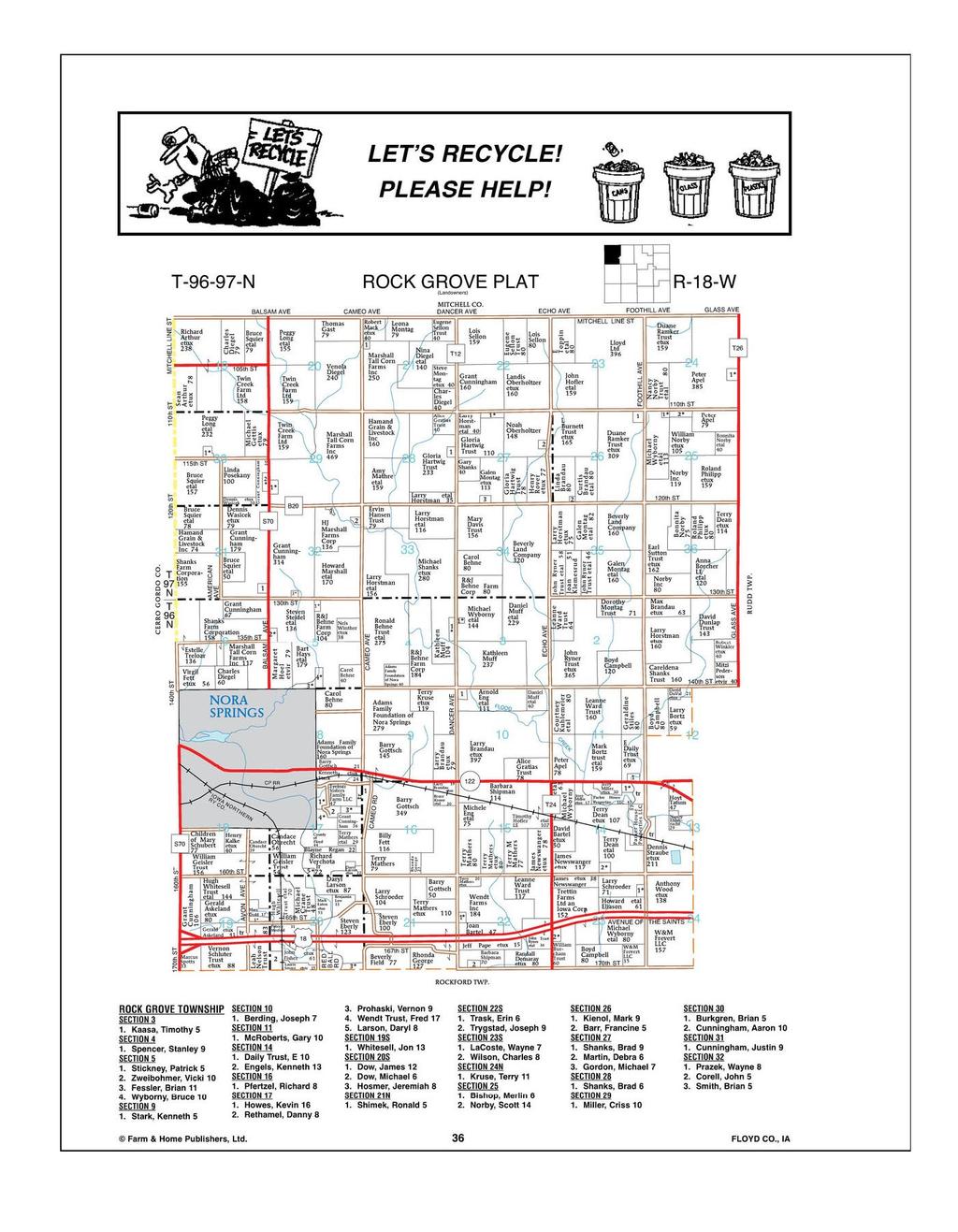
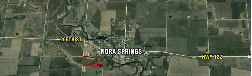
2 LAND FOR SALE LEGAL DESCRIPTION: Part of the North 1/2 of the Northwest 1/4, Section 18, Township 96 North, Range 18 West, Floyd Co., IA COMMENTS & BUILDING INFORMATION: Peoples Company is offering 30 acres m/l of productive Floyd County, Iowa farmland. This farm consists of FSA cropland acres with a 4 acres of CRP. The farm carries effective crop acres of with a 65.8 CSR2 on the tillable acres. Productive soil types include Calco and Clyde Loams. Farm is located just SW of Nora springs in Section 18 of Rock Grove Township, Floyd County, Iowa. This farm is leased for the 2017 crop year. LEASE/FSA INFORMATION: Leased for the 2017 crop year. Trenton LLC, 30 Acres M/L, Floyd County, IA TOTAL ACRES: 30 PRICE: $135,000 Price Per Acre: $4,500 Owner: Trenton LLC Operator: Fett County & State: Floyd Co., IA Location: Nora Springs, Ia Possession Date: As agreed Drainage Info: Natural Average Productivity: 69.1 CSR & 68.7 CSR2 Taxable Acres: Net RE Taxes: $480 Taxes Payable In: 2016 Topography: Level to Gentle Slope F.S.A. INFORMATION: APPROXIMATE BREAKDOWN OF ACRES: DOUGLAS R. YEGGE C: O: Doug@PeoplesCompany.com ALAN MCNEIL C: O: Alan@PeoplesCompany.com Farmland: Crop Acres: CRP Acres: 4 Wheat Base: Wheat Yield: Corn Base: 13.1 Corn Yield: 146 Soybean Base: 10.1 Soybean Yield: 42 Total Acres: Tillable Acres: CRP Acres: 4 Farmstead: Roads: 2.63 Waterways: Timber: Pasture:
3
4 Aerial Map - Trenton LLC Total Acres map center: 43 8' 20.61, -93 1' ft 292ft 584ft 18-96N-18W Floyd County Iowa 5/18/2017 Field borders provided by Farm Service Agency as of 5/21/2008.
5 Soils Map - Trenton LLC Total Acres State: County: Location: Township: Iowa Floyd 18-96N-18W Rock Grove Acres: Date: 5/18/2017 Soils data provided by USDA and NRCS. Area Symbol: IA067, IA067, Soil Soil Area Area Version: Version: Code Soil Description Acres Percent of field CSR2 Legend 733 Calco silty 2 percent 84 Clyde silty 3 percent 214 Rockton loam, 20 to 30 inches to limestone, 0 to 2 percent 651 Faxon silty 2 percent 1152 Marshan clay loam, 0 to 2 percent, rarely flooded 27B Terril loam, 2 to 5 percent 631C Limecreek silty clay loam, 5 to 9 percent Non Irr Class *c *i Corn *i Alfalfa *i Soybeans *i Bluegrass *i Tall Grasses CSR2** CSR Corn Oats Soybeans NCCPI Overall % IIw % IIw % IIs % IIIw % IIw % IIe % IIIe
6 214B 412C 171B 171D2 Rockton loam, 20 to 30 inches to limestone, 2 to 5 percent Emeline loam, 2 to 9 percent Bassett loam, 2 to 5 percent Bassett loam, 9 to 14 percent, eroded % IIe % IVs % IIe % IIIe Weighted Average **IA has updated the CSR values for each county to CSR2. *i Yield data provided by the ISPAID Database version 8.1 developed by IA State University. *c: Using Capabilities Class Dominant Condition Aggregation Method Soils data provided by USDA and NRCS.

7 Aerial Map - Trenton LLC Tillable Acres map center: 43 8' 20.61, -93 1' ft 292ft 584ft 18-96N-18W Floyd County Iowa 5/18/2017 Field borders provided by Farm Service Agency as of 5/21/2008.


8 Soils Map - Trenton LLC Tillable Acres State: County: Location: Township: Iowa Floyd 18-96N-18W Rock Grove Acres: Date: 5/18/2017 Soils data provided by USDA and NRCS. Area Symbol: IA067, IA067, Soil Soil Area Area Version: Version: Code Soil Description Acres Percent of field CSR2 Legend 84 Clyde silty 3 percent 214 Rockton loam, 20 to 30 inches to limestone, 0 to 2 percent 651 Faxon silty 2 percent 1152 Marshan clay loam, 0 to 2 percent, rarely flooded 27B Terril loam, 2 to 5 percent 733 Calco silty 2 percent 214B Rockton loam, 20 to 30 inches to limestone, 2 to 5 percent Non Irr Class *c *i Corn *i Alfalfa *i Soybeans *i Bluegrass *i Tall Grasses CSR2** CSR Corn Oats Soybeans NCCPI Overall % IIw % IIs % IIIw % IIw % IIe % IIw % IIe
9 412C 171B 171D2 631C Emeline loam, 2 to 9 percent Bassett loam, 2 to 5 percent Bassett loam, 9 to 14 percent, eroded Limecreek silty clay loam, 5 to 9 percent % IVs % IIe % IIIe % IIIe Weighted Average **IA has updated the CSR values for each county to CSR2. *i Yield data provided by the ISPAID Database version 8.1 developed by IA State University. *c: Using Capabilities Class Dominant Condition Aggregation Method Soils data provided by USDA and NRCS.

10 Aerial Map - Trenton LLC CRP Acres map center: 43 8' 20.61, -93 1' ft 269ft 538ft 18-96N-18W Floyd County Iowa 5/18/2017 Field borders provided by Farm Service Agency as of 5/21/2008.

11 Soils Map - Trenton LLC CRP Acres State: County: Location: Township: Iowa Floyd 18-96N-18W Rock Grove Acres: 4 Date: 5/18/2017 Soils data provided by USDA and NRCS. Area Symbol: IA067, IA067, Soil Soil Area Area Version: Version: Code Soil Description Acres Percent of field CSR2 Legend Non Irr Class *c 733 Calco silty clay loam, 0 to 2 percent 84 Clyde silty clay loam, 0 to 3 percent 651 Faxon silty 2 percent *i Corn *i Alfalfa *i Soybeans *i Bluegrass *i Tall Grasses CSR2** CSR Corn Oats Soybeans NCCPI Overall % IIw % IIw % IIIw **IA has updated the CSR values for each county to CSR2. Weighted Average *i Yield data provided by the ISPAID Database version 8.1 developed by IA State University. *c: Using Capabilities Class Dominant Condition Aggregation Method Soils data provided by USDA and NRCS.


12 WEST DRIVE
13
LAND FOR SALE 314 ACRES M/L BERG, WORTH COUNTY, IOWA LISTING # DOUGLAS R. YEGGE C: O:
 LAND FOR SALE LISTING #13870 314 ACRES M/L BERG, WORTH COUNTY, IOWA DOUGLAS R. YEGGE C: 563-320-9900 O: 563-659-8185 Doug@PeoplesCompany.com ALAN MCNEIL C: 563-321-1125 O: 563-659-8185 Alan@PeoplesCompany.com
80 ACRES M/L CEDAR COUNTY, IA LISTING #465 DOUGLAS R. YEGGE ALAN MCNEIL. C: O:
 80 ACRES M/L CEDAR COUNTY, IA LISTING #465 DOUGLAS R. YEGGE C: 563-320-9900 O: 563-659-8185 total@totalrealtyco.com ALAN MCNEIL C: 563-321-1125 O: 563-659-8185 alan@totalrealtyco.com Kroemer, 80 Acres
LAND FOR SALE 82 ACRES M/L CEDAR COUNTY, IOWA LISTING # DOUGLAS R. YEGGE C: O:
 LAND FOR SALE LISTING #13968 82 ACRES M/L CEDAR COUNTY, IOWA DOUGLAS R. YEGGE C: 563-320-9900 O: 563-659-8185 Doug@PeoplesCompany.com ALAN MCNEIL C: 563-321-1125 O: 563-659-8185 Alan@PeoplesCompany.com
131 ACRES M/L VAN BUREN COUNTY, IOWA LISTING #458 JIM KEDLEY. C: O:
 131 ACRES M/L VAN BUREN COUNTY, IOWA LISTING #458 JIM KEDLEY C: 563-212-5401 O: 563-659-8185 Jimkedley@totalrealtyco.com CWC Holdings LLC, 131 Acres M/L, Van Buren County, IA TOTAL ACRES: 131 MOL PRICE:
FARMLAND AUCTION. FSA INFORMATION: Farmland: acres Cropland: acres Tillable: acres
 FARMLAND AUCTION January 22, 2019 at 10:30 am Keep an eye on BarnesRealty.com for possible blizzard date of 1/24/2019 Fisher Community Center, 201 E. Iowa St. Hiawatha, KS 66434 Here is a very productive
80 ACRES M/L BOONE COUNTY, IOWA LISTING # Pilot Mound, Iowa. I Avenue. 130th Street. Co Hwy P th Street
 Co Hwy P70 I Avenue 80 ACRES M/L BOONE COUNTY, IOWA CAPTION Pilot Mound, 130th Street 130th Street LISTING #12320 New Listing Price! $800,000 DESCRIPTION: High Quality Farm in Strong Farming Area and potential
365.8 Acres +/- Brown County, KS February 28, 2019 at 10:30 am Community Building, 511 West Front Street, Fairview, KS
 Farmland Auction February 28, 2019 at 10:30 am Community Building, 511 West Front Street, Fairview, KS This excellent Brown County farm is just North of Fairview, KS and it will be selling in 3 tracts
173 ACRES - RILEY COUNTY, KS
 Buyers, Sellers & Land Connected PRICE: $690,000 ACRES: 173 COUNTY: RILEY STATE: KANSAS First Class Hunting with Outstanding Income Potential If you have ever dreamed of owning your very own piece of first
Demoss Farm & Home 118 Acres, M/L W. 209th Ave. Pattonsburg, Mo 64670
 118 Acres, M/L 39436 W. 209th Ave. Pattonsburg, Mo 64670 PRICE: $400,000.00 LAND USE: FSA shows approx. 118.32 farmland acres, ml, of which there were 36.47 acres of effective cropland with the remainder
State: Kansas County: Sherman Location: S-037W Township: Union Acres: Date: 12/19/2011. Maps provided by:
 Soils Map State: Kansas County: Sherman Location: 007-009S-037W Township: Union Acres: 147.8 Date: 12/19/2011 Fsa borders provided by the Farm Service Agency as of May 23, 2008. Soils data provided by
268 Acres m/l, Iowa County, IA. Offered in 2 Remaining Parcels. Parcel Ac. m/l Parcel 2-81 Ac. m/l Parcel 3-45 Ac. m/l - SOLD!
 LAND FOR SALE 268 Acres m/l, Iowa County, IA Offered in 2 Remaining Parcels Parcel 1-187 Ac. m/l Parcel 2-81 Ac. m/l Parcel 3-45 Ac. m/l - SOLD! Golden Grain Enterprises Good Iowa County Farms Located
Farmland For Sale 3 Tracts /- acres Webster County, Iowa Section 31, T88N, R30W & Section 33, T88N, R29W
 Farmland For Sale 3 Tracts 316.02 +/- acres Webster County, Section 31, T88N, R30W & Section 33, T88N, R29W Contact Martin today! 309-242-7299 mthornton@hbtbank.com Martin G. Thornton, Broker 200 W. College
Aerial Map. map center: 38 0' 55.53, ' S-4E Franklin County Illinois
 Aerial Map map center: 38 0' 55.53, -88 42' 58.78 0ft 594ft 1188ft 11/24/2016 Field borders provided by Farm Service Agency as of 5/21/2008. Soils data provided by University of at Champaign-Urbana. Topography
Auction Location Eagles Club 316 S. 2 nd Street, Aberdeen, SD
 Auction Location Eagles Club 316 S. 2 nd Street, Aberdeen, SD Welcome We would like to invite and welcome you to our public auction! This is an excellent opportunity to add Brown County cropland to your
Land Sales Specialists Setting the trend for how Real Estate is sold in the Midwest.
 Land Sales Specialists Setting the trend for how Real Estate is sold in the Midwest. www.barnesrealty.com 18156 Hwy 59 Mound City, MO 64470 (660) 442-3177 1711 Oregon Hiawatha, KS 66434 (785) 742-4580
FOR SALE NEW PRICE HILL FAMILY FARM WATKINS CORNER, AR. Phillips County, Arkansas: 2,300+/- Acre Irrigated Grain Farm NEW PRICE/YIELD UPDATES:
 NEW PRICE FARMLAND ADVISORS FOR SALE HILL FAMILY FARM WATKINS CORNER, AR 2,300+/- Acres - Phillips County, Arkansas $10,950,000 Phillips County, Arkansas: 2,300+/- Acre Irrigated Grain Farm NEW PRICE/YIELD
Deuel County Dryland
 Deuel County Dryland Two parcels of dryland farm ground near Lewellen, NE Property Highlights List Price $852,474 $786,877 Location 12-15 miles south of Lewellen, Ne or the same distance from Big Springs,
FOR SALE HILL FAMILY FARM WATKINS CORNER, AR. Phillips County, Arkansas: 2,300+/- Acre Irrigated Grain Farm NEW PRICE/YIELD UPDATES:
 SOLD FARMLAND ADVISORS FOR SALE HILL FAMILY FARM WATKINS CORNER, AR 2,300+/- Acres - Phillips County, Arkansas $10,950,000 Phillips County, Arkansas: 2,300+/- Acre Irrigated Grain Farm NEW PRICE/YIELD
+/- 60 AC LAND FOR SALE HARLEY ROAD, ELBURN, IL 60119
 Land For Sale OFFERING SUMMARY Sale Price: $660,000 Price / Acre: $11,000 PROPERTY OVERVIEW +/- 60 acres available for purchase on the west side of Harley Road, South of Rt. 38. This site has Harley Road
WALKER FEEDLOT Total taxable acres, part fenced. 4 homes & multiple nice/modern outbldgs hd feedyard with sprinklers a-shkd-0002
 ABILENE WALKER FEEDLOT 38.7 Total taxable acres, part fenced 4 homes & multiple nice/modern outbldgs 3500 hd feedyard with sprinklers a-shkd-0002 Center pivot irrigation from lagoons 999 hd feedlot A-SHDK-B020
SW CORNER ROUTE 38 AND HARLEY ROAD SW CORNER ROUTE 38 & HARLEY ROAD, KANE COUNTY, IL 60119
 REDUCED: Land For Sale SW CORNER ROUTE 38 AND HARLEY ROAD REDUCED: 124 AC ON IL ROUTE 38 OFFERING SUMMARY Sale Price: $1,643,000 Price / Acre: $13,250/AC PROPERTY OVERVIEW This 124 AC parcel has approximately
For Sale at $290,000.00
 We are pleased to present Stearns Property 77± Acres Forest Township, Rice County For Sale at $290,000.00 Listing Agent: Charles Wingert Office: 507-345-LAND (5263) Toll Free: 800-730-LAND (5263) Direct:
Pifer s. 1, /- Acres Clay County, MN. Written Bid. Land For Lease. WRITTEN BIDS DUE BEFORE: Friday, January 19, :00 p.m.
 1,666.53 +/- Acres Clay County, MN Written Bid Land For Lease WRITTEN BIDS DUE BEFORE: Friday, January 19, 2018 5:00 p.m. OWNER: Hogetvedt Family Rev Trust STOCK PHOTO General Information Land Lease Auction
280 ACRES - HOWELL COUNTY, MO
 PRICE: $434,700 ACRES: 280 COUNTY: HOWELL STATE: MISSOURI For more information contact: KYLE ORF, Land Agent 417.988.3333 KyleOrf@MidwestLandGroup.com MidwestLandGroup.com 100 280ACRES ACRES- -COUNTY,
LAND AUCTION. Open House: Saturday, August 6th and Saturday, August 20th From 9:00 AM to 11:00 AM at 1220 C Avenue, Scranton, Iowa
 L-1005 LAND AUCTION 1,235+/- Acres, Carroll and Greene Counties, Iowa Friday, August 2, 201 10:00 AM at the Saint Joseph s Parish Center 501 North Locust Street Jefferson, Iowa Highlight Features: Over
Harding Real Estate Vacant Acres Thompson Rd., Woodstock, IL
 Harding Real Estate 325.31 Vacant Acres Thompson Rd., Woodstock, IL Randy Erwin, Broker Associate Natalie Torres, Broker Associate BHHS Starck Real Estate 1710 South Eastwood Dr. Woodstock, IL. 60098 Randy@RandyErwin.com
LAND FOR SALE. Beautiful Farmstead. Pifer s. Price: $1,250, /- Acres Green County, WI
 Beautiful Farmstead LAND FOR SALE 176 +/- Acres Green County, WI Price: $1,250,000 Auction & Realty - Robert Scott Pifer, Broker (#56685-90) RE Entity License #937110-91, Auction Company License #429-53
G T12 G J44 G J46 ST 2. Jerome. Martinstown. Numa. A Maryanna F. Wallin Estate Appanoose County, Iowa
 135th Ave 150th Ave 153rd Ave Elm St N 170th Ave 171st Ave 172nd St 175th Ave 51 0th St Highw ay 2 Highw ay 2 ST 2 Highw ay 2 G T12 135th Ave 522nd St 523rd St Jerome 140th Ave 524th St 1 2 G J44 3 160th
Northeast Perkins County Pivots
 Northeast Perkins County Pivots 315.9± acres of center pivot irrigated farmland Southeast of Paxton, NE Email: Jordan@lashleyland.com Property Highlights List Price $1,550,000 Location Southeast of Paxton,
2016 Iowa FFA Soils Evaluation CDE Exam
 2016 Iowa FFA Soils Evaluation CDE Exam 1. Which of the following is true regarding soil horizons? a. A horizon is darker in color and has more organic matter b. B horizon is darker in color and has more
/- Acres Becker County, MN (see pgs 1-6) /- Acres Clay County, MN (see pgs 8-14) Pifer s Written Bid.
 /- Acres Clay County, MN (see pgs 8-14) Pifer s Written Bid.") 812.02 +/- Acres Becker County, MN (see pgs 1-6) 810.14 +/- Acres Clay County, MN (see pgs 8-14) Written Bid Land For Lease WRITTEN BIDS DUE BEFORE: Friday, December 8, 2017 5:00 p.m. OWNERS: Case Agricultural
812.02 +/- Acres Becker County, MN (see pgs 1-6) 810.14 +/- Acres Clay County, MN (see pgs 8-14) Written Bid Land For Lease WRITTEN BIDS DUE BEFORE: Friday, December 8, 2017 5:00 p.m. OWNERS: Case Agricultural
Tract 1. Tract 3. Tract 2. Tract 4. A Taylor Co., IA
 Newport Ave Sec. 7 Sec. 8 235th St Sec. 13 250 th St Sec. 18 Maryl and Ave Sec. 17 T68N R34W T68N R33W 250 th St Sec. 24 257t h St Sec. 19 2 Newp ort Way Sec. 20 Sec. 25 Latitude: 40.6872 N Longitude:
2014 Iowa FFA Soil Judging CDE Exam
 2014 Iowa FFA Soil Judging CDE Exam 1. Landscape position is one aspect of evaluating the surface features of a certain tract of land. Identifying the correct landscape position will indicate: a. If the
We are pleased to present Leonard Thorston Revocable Trust ± Acres Charleston Township, Redwood County
 We are pleased to present Leonard Thorston Revocable Trust 158.72 ± Acres Charleston Township, Redwood County PARCEL 1 PARCEL 2 This property to be sold by Sealed Bid Auction Owner: Leonard Thorston Family
FARMLAND FOR SALE ± Acres 5 Tracts
 Now is your chance to acquire productive farmland in Greene County, Illinois. Greene County, IL FARMLAND FOR SALE 756.08± Acres 5 Tracts Highly productive riverbottom farms Heavily improved with tiling
Rural Soils Career Development Event
 Rural Soils Career Development Event Effective August 1, 2014 Important Note: Please thoroughly read the Introduction and General Rules Section at the beginning of this handbook for complete rules and
STATE TAX COMMISSION OF MISSOURI ASSESSOR MANUAL
 STATE TAX COMMISSION OF MISSOURI ASSESSOR MANUAL CHAPTER: REVISION DATE: 10/1/2008 Page 1 of 18 7.3 The purpose of this section of the Assessor s Manual is to supplement the State Tax Commission s published
Iowa FFA Soil Career Development Event 2008
 Iowa FFA Soil Career Development Event 2008 1. In Iowa, corn suitability ratings for soil mapping units specifies a. natural weather conditions b. surface and subsurface drainage installed where needed
Soils and their Relationship with Agriculture
 Soils and their Relationship with Agriculture Presentation created by Thomas Gallagher Modified by Hank Bignell Capital Area Agriculture and Horticulture Program Cornell University Cooperative Extension
Farmland Classification Centre County, Pennsylvania (Student Farm Site) Web Soil Survey National Cooperative Soil Survey
 Web Soil Survey National Cooperative Soil Survey") 256300 256600 256900 257200 257500 257800 258100 77 51' 20'' W 77 53' 26'' W Farmland Classification Centre County, Pennsylvania 258400 258700 259000 40 49' 4'' N 4520600 4520900 4520900 4521200 4521200
256300 256600 256900 257200 257500 257800 258100 77 51' 20'' W 77 53' 26'' W Farmland Classification Centre County, Pennsylvania 258400 258700 259000 40 49' 4'' N 4520600 4520900 4520900 4521200 4521200
Sacramento River Farmland Anderson, California
 AG-LAND INVESTMENT BROKERS 275 Sale Lane / P. O. Box 896 Red Bluff, CA 96080 530.529.4400 office / 530.527.5042 fax Sacramento River Farmland Anderson, California Property: 43 +/- acres of farmland with
IOWA FFA STATE SOILS CDE SATURDAY, OCTOBER 13, 2007 AMES, IOWA
 IOWA FFA STATE SOILS CDE SATURDAY, OCTOBER 13, 2007 AMES, IOWA 1. Moderately sloping has what percent slope: a. 9-14% b. 2-5% c. 5-9% d. over 14% 2. Which of the following horizons is the loose underlying
Horner-McLaughlin Woods: Soil Types
 Horner-McLaughlin Woods: Soil Types Not present at HMW Adrian Muck Conover Loam 0-4% Slopes Houghton Muck Miami Loam 2-6% Slopes Miami Loam 6-12% Slopes Miami Loam 12-18% Slopes t 0 0.125 0.25 Miles Mary
TP73 4PTP101 TP45 TP9 TP74 TP46 TP47 TP115 TP48 TP32 TP5 TP31 TP22 TP49 V58 TP57 4F TP50 TP51 3PD 3PD TP80 TP28 TP55
 Figure 2.1-3 - Capability Assessment Map Part of Lots 18 and 19, Concession 3 Township of Russell sified unclas TP72 TP90 TP624P V18 3D TP35 TP73 4PTP101 3D TP45 TP9 TP74 TP89 TP117 V61 V34 TP19 TP20 TP100
Yields of Non-Irrigated Crops (Component): Soybeans (Bu) Edgecombe County, North Carolina, and Halifax... (SOYBEANS)
: Soybeans (Bu) Edgecombe County, North Carolina, and Halifax... (SOYBEANS)") 77 37' 52'' W Yields of Non-Irrigated Crops (Component): Soybeans (Bu) Edgecombe County, North Carolina, and Halifax... () 77 36' 28'' W 263300 263600 263900 264200 264500 264800 265100 36 6' 59'' N 36
77 37' 52'' W Yields of Non-Irrigated Crops (Component): Soybeans (Bu) Edgecombe County, North Carolina, and Halifax... () 77 36' 28'' W 263300 263600 263900 264200 264500 264800 265100 36 6' 59'' N 36
 108 40' 29'' W Soil Map Mesa County Area, Colorado 108 36' 55'' W 39 10' 11'' N 39 6' 31'' N 4331700 4332500 4333300 4334100 4334900 4335700 4336500 4337300 4338100 701100 701900 702700 703500 704300 705100
2018 Iowa FFA Soil Judging CDE Exam 1. Landscape positions characterizes the location of the soil on the landscape and identifies potential risks.
 2018 Iowa FFA Soil Judging CDE Exam 1. Landscape positions characterizes the location of the soil on the landscape and identifies potential risks. Which landscape position is considered the floodplain
Custom Soil Resource Report for Orange County, Virginia
 United States Department of Agriculture Natural Resources Conservation Service A product of the National Cooperative Soil Survey, a joint effort of the United States Department of Agriculture and other
Unit II Soil Management
 Unit II Soil Management Lesson 2: Using Soil Survey Manuals Soil survey manuals provide useful information for grassland management. Soil scientists evaluate the soil for chemical and physical properties,
Custom Soil Resource Report Soil Map
 77 11' 22'' W Custom Soil Resource Report Soil Map 77 9' 43'' W 36 48' 13'' N 304700 304900 305100 305300 305500 305700 305900 306100 306300 306500 306700 306900 307100 36 48' 13'' N 36 47' 21'' N 4073800
Area 3 Envirothon Soils Questions Key
 Area 3 Envirothon Soils Questions Key 1. Soil aeration is the exchange of air in soil with air from the atmosphere. When a soil is well aerated, the air within the soil is very similar to the atmosphere
Colusa County Almonds
 Morgan Houchin. 3430 Unicorn Road Bakersfield, CA 93308 mobile office efax 526.97 +/- Acres of Colusa County Almonds Cork McIsaac, Broker. Broker License No. 01216717 P.O. Box 1076 West Sacramento, CA
II We Fall-plow or Spring-plow
 II We Fall-plow or Spring-plow r,n Illinois? an JU L 11 R. S. SMITH, in Soil Physics and Soi' Survey., t lllii'vl\).. THE PROBLEM wl1'eth~ 0 f I-plow or to spring-plow IS an especially difficult one in
House & 3.21 Acres, Linn County, IA. 927 Linn Ridge Road, Mount Vernon, Iowa 52314
 ACREAGE FOR SALE House & 3.21 Acres, Linn County, IA 927 Linn Ridge Road, Mount Vernon, Iowa 52314 Property Information Location From Mount Vernon: Four miles north on Springville Road and one mile west
2017 Iowa FFA Soil Judging CDE Exam
 2017 Iowa FFA Soil Judging CDE Exam 1. Landscape positions vary in soil composition and makeup. What landscape position would be characterized by having strata and lenses of different textures in the profile:
Custom Soil Resource Report for Craighead County, Arkansas
 United States Department of Agriculture Natural Resources Conservation Service A product of the National Cooperative Soil Survey, a joint effort of the United States Department of Agriculture and other
Alternative Crop Suitability Methodology
 Alternative Crop Suitability Methodology The Alternative Agriculture in Missouri Hub on Community Commons includes model-based ratings of natural suitability for selected alternative crops. These ratings
2016 Area 3 Envirothon Muskingum County Soils Test ANSWER KEY
 2016 Area 3 Envirothon Muskingum County Soils Test ANSWER KEY 1. The majority of the bedrock in Muskingum County is. a. sedimentary bedrock b. glacial bedrock c. igneous bedrock d. metamorphic bedrock
1. Position (2 pts.) 2. Parent Material (2 pts.) 3. Slope Characteristics (2 pts.) 4. Surface Stoniness or Rockiness (2 pts.)
 2. Parent Material (2 pts.) 3. Slope Characteristics (2 pts.) 4. Surface Stoniness or Rockiness (2 pts.)") Maryland Envirothon SOILS Exam Guidance Information (revised 2017) Objective: To test students' knowledge and awareness of basic soil science and its application in wise land-use planning and therefore
Maryland Envirothon SOILS Exam Guidance Information (revised 2017) Objective: To test students' knowledge and awareness of basic soil science and its application in wise land-use planning and therefore
Custom Soil Resource Report for Centre County, Pennsylvania
 United States Department of Agriculture Natural Resources Conservation Service A product of the National Cooperative Soil Survey, a joint effort of the United States Department of Agriculture and other
Annual lease of the tillable acreage for crops (soybeans and/or corn).
.") FOR SALE $895,000.00 11201 Hill Road, Woodsboro, Maryland 21798 Crop Farm with Subdivision Potential PRESENTING Location: 11201 Hill Road, Woodsboro, MD 132.2064 acre crop farm with extraordinary views,
FOR SALE $895,000.00 11201 Hill Road, Woodsboro, Maryland 21798 Crop Farm with Subdivision Potential PRESENTING Location: 11201 Hill Road, Woodsboro, MD 132.2064 acre crop farm with extraordinary views,
Soil Survey of San Luis Obispo County, California Paso Robles Area
 United States Department of Agriculture Soil Conservation Service In cooperation with University of California Agricultural Experiment Station Soil Survey of San Luis Obispo County, California Paso Robles
MANAGING ACIDIC SOILS: HERBICIDE AND FERTILITY STRATEGIES FOR FARM AND GARDEN
 MANAGING ACIDIC SOILS: HERBICIDE AND FERTILITY STRATEGIES FOR FARM AND GARDEN DOUG FINKELNBURG UI EXTENSION SOIL ACIDITY WHAT IS ACIDITY? NATURALLY ACIDIFYING PROCESSES Rainfall Organics Accumulation Plant
Custom Soil Resource Report for Centre County, Pennsylvania
 United States Department of Agriculture Natural Resources Conservation Service A product of the National Cooperative Soil Survey, a joint effort of the United States Department of Agriculture and other
Richfield Prunes, Pistachios & Walnuts
 AG-LAND Investment Brokers 275 Sale Lane Red Bluff, CA 96080 530-529-4400 Fax 530-527-5042 Richfield Prunes, Pistachios & Walnuts 210 +/- acres 3 Parcels Corning, CA - Tehama County jsubject AG-LAND
Farmers need to develop an understanding
 Fact Sheet 782 Basics of Soil and Plant Fertility Farmers need to develop an understanding of the basics of soil physiology and the factors that affect plant fertility. Not only is this knowledge essential
Custom Soil Resource Report for Centre County, Pennsylvania
 United States Department of Agriculture Natural Resources Conservation Service A product of the National Cooperative Soil Survey, a joint effort of the United States Department of Agriculture and other
Soil characteristics that influence nitrogen and water management
 Section C Soil characteristics that influence nitrogen and water management Soil characteristics vary across the landscape Soils vary from one field to another, and often within the same field. Soil differences
Inherent Factors Affecting Soil ph. Soil ph Management
 Soil ph is a measure of soil acidity or alkalinity. It is an important indicator of soil health. It affects crop yields, crop suitability, plant nutrient availability, and soil micro-organism activity,
Predicting Design Storm Runoff for the Six Mile Creek Watershed: Effects of the Potential Sprawl-Is-Us, Inc. Development
 Predicting Design Storm Runoff for the Six Mile Creek Watershed: Effects of the Potential Sprawl-Is-Us, Inc. Development Ross Guida Faulkner Consulting Engineers, Inc. December 19, 2008 1 Table of Contents
DO YOU KNOW YOUR SOILS? (Rev. 10/11)
") DO YOU KNOW YOUR SOILS? (Rev. 10/11) Circle all the correct answers. 1. What is the layer normally present on the surface of the soil in cropped fields? a. O c. Ap e. B g. R b. A d. E f. C 2. Available
DO YOU KNOW YOUR SOILS? (Rev. 10/11) Circle all the correct answers. 1. What is the layer normally present on the surface of the soil in cropped fields? a. O c. Ap e. B g. R b. A d. E f. C 2. Available
Inherent Factors Affecting Soil ph. Soil ph Management
 Soil ph is a measure of soil acidity or alkalinity. It is an important indicator of soil health. It affects crop yields, crop suitability, plant nutrient availability, and soil micro-organism activity
Land for Sale. Marion County, Georgia. $2,160,000 +/- 900 Acres $2,400 per Acre
 Land for Sale Marion County, Georgia 2 Contents Property Fact Sheet... 3 Regional Map... 4 Local Map... 5 Aerial Map... 6 Major Soil Types Map... 7 Soil Classification Map... 8 Soil Classification Table...
Custom Soil Resource Report for Fond du Lac County, Wisconsin
 United States Department of Agriculture Natural Resources Conservation Service A product of the National Cooperative Soil Survey, a joint effort of the United States Department of Agriculture and other
2 Older farm homes on the land
 2 Older farm homes on the land LAND RANCHES EXCHANGES This ranch consists of 70 +/_ acres of level farmland. Prime 13700 POWERHOUSE RD POTTER VALLEY agricultural land at an attractive price. This property
Nebraska Soil Science Curriculum
 Nebraska Soil Science Curriculum Soil ph: What affects it, what it affects, managing it and testing it Approximately 135 minutes ***Content and lab derived from the USDA-NRCS Guides for Educators. Please
Surface Coal Mining and Reclamation in ND. Guy Welch ND Public Service Commission
 Surface Coal Mining and Reclamation in ND Guy Welch ND Public Service Commission Surface Coal Mines in North Dakota Approximately 1500 acres are disturbed each year History of Reclamation in ND First surface
Soil sampling & liming: Key steps in maintaining soil health
 Soil sampling & liming: Key steps in maintaining soil health Carrie Laboski Carrie Laboski, Ph.D. CPSS, Professor & Extension Soil Fertility/Nutrient Management Specialist 1 This could be avoided with
Custom Soil Resource Report for Kane County, Illinois
 United States Department of Agriculture Natural Resources Conservation Service A product of the National Cooperative Soil Survey, a joint effort of the United States Department of Agriculture and other
NYC Envirothon 2017 Soil Science Review. Richard K Shaw USDA-NRCS
 NYC Envirothon 2017 Soil Science Review Richard K Shaw USDA-NRCS Introduction Who Are We? U.S. Department of Agriculture (1862) Natural Resources Conservation Service (1935) What Do We Do? Provide leadership
2012 FINAL SOILS AREA 2 Envirothon Questions Answer KEY
 2012 FINAL SOILS AREA 2 Envirothon Questions Answer KEY Questions 1-6 to be answered at the soil pit: 1. Soil scientists categorize soils by drainage classes. What is the drainage class of the soil at
September 20, 2016 Soils Investigation for Agricultural Designation Windemere Place, Missoula County, Montana
 September 20, 201 Soils Investigation for Agricultural Designation Windemere Place, Missoula County, Montana The purpose of this report is to compare on-site soils of the proposed subdivision with the
Land Capability Classifications
 Land Capability Classifications Unit: Soil Science Problem Area: Basic Principles of Soil Science Student Learning Objectives. Instruction in this lesson should result in students achieving the following
Soil Science Society of America. What is Miami Soil? Where to dig Miami
 Miami Indiana State Soil Soil Science Society of America Introduction Many states have a designated state bird, flower, fish, tree, rock, etc. And, many states also have a state soil one that has significance
EXHIBIT 5-1 VILLAGE OF WILD ROSE FUNCTIONAL CLASS AND AVERAGE DAILY TRAFFIC VOLUMES 2000 & 2003 DATA
 3400 3600 EXHIBIT 5-1 FUNCTIONAL CLASS AND AVERAGE DAILY TRAFFIC VOLUMES 2000 & 2003 DATA Rural Minor Arterial Rural Major Collector Rural Minor Collector Rural Local 2000 Traffic Count 2003 Traffic Count
26 Attachment 2. Township of New Britain APPENDIX B STORMWATER MANAGEMENT DESIGN CRITERIA
 (26, APPENDIX B) 26 Attachment 2 Township of New Britain APPENDIX B STORMWATER MANAGEMENT DESIGN CRITERIA TABLE B-1 DESIGN STORM RAINFALL AMOUNT Source: Field Manual of Pennsylvania Department of Transportation
Blue Fox Farm $1,795,000
 Offered Exclusively By: Blue Fox Farm 6105 Sulphur Well Road 117± acres Fayette County $1,795,000 Zach Davis Principal Broker +1.859.576.8195 www.kirkfarms.com zach@kirkfarms.com Hannah Davis Emig Agent
SOIL FORMATION AND LANDSCAPE STABILITY
 SOIL FORMATION AND LANDSCAPE STABILITY Smith and Pun, Chapter 14 WHAT IS SOIL? Soils are natural three-dimensional bodies used for many purposes, the most important of which is to produce food and fiber
Holdrege. Nebraska State Soil. Soil Science Society of America. Introduction. History. What is Holdrege Soil? Where to dig a Holdrege.
 Holdrege Nebraska State Soil Soil Science Society of America Introduction Many states have a designated state bird, flower, fish, tree, soil, rock, etc. And, many states also have a state soil - one that
Bull Canyon Ranch 2750 BULL CANYON ROAD, SANTA MARIA, CALIFORNIA PRESENTED FOR SALE BY: Rincon corporation
 Bull Canyon Ranch 2750 BULL CANYON ROAD, SANTA MARIA, CALIFORNIA PRESENTED FOR SALE BY: Rincon corporation THE FULL SERVICE REAL ESTATE COMPANY FOR THE AGRICULTURAL COMMUNITY Bull canyon ranch, santa maria
Custom Soil Resource Report for Yamhill Area, Oregon
 United States Department of Agriculture Natural Resources Conservation Service A product of the National Cooperative Soil Survey, a joint effort of the United States Department of Agriculture and other
Publication 122 January 2012 Instructions for Farmland Assessments
 Illinois Department of Revenue Brian Hamer, Director Publication 122 January 2012 Instructions for Farmland Assessments The information in this publication is current as of the date of the publication.
Soil Interpretations Erosion and Sedimentation Control Planning and Design Workshop
 Soil Interpretations Erosion and Sedimentation Control Planning and Design Workshop Presented by Richard Brooks Presentation prepared by Kristin May Resource Soil Scientists USDA-Natural Resources Conservation
3. What are the five master horizons? Give distinguishing features of each. 5. List three means by which plant roots come into contact with nutrients.
 Study Questions Exam 1 1. What are the four general components of soil? 2. Define regolith and solum. 3. What are the five master horizons? Give distinguishing features of each. 4. What is meant by an
Land Capability Class
 Guide for Applying Conservation Treatments for Land Evaluation (5/23/2011) LAND TREATMENT After examining and determining the physical features of the soil profile, one can determine the land capability
Custom Soil Resource Report for Pope County, Illinois
 United States Department of Agriculture Natural Resources Conservation Service A product of the National Cooperative Soil Survey, a joint effort of the United States Department of Agriculture and other
CHECKLIST BMPs for FIELD NURSERIES REGULATIONS, SITE SELECTION, WATER MANAGEMENT
 CHECKLIST BMPs for FIELD NURSERIES REGULATIONS, SITE SELECTION, WATER MANAGEMENT Regulations For information on the Wetlands Protection Act or the Water Management Act, contact the Massachusetts Department
POLLINATOR HABITAT PLANTING
 POLLINATOR HABITAT PLANTING Michigan CRP - SAFE CP-38E Pollinator Natural Resources Conservation Service (NRCS) Pollinators provide a very important ecological service. Approximately three quarters of
Custom Soil Resource Report for Centre County, Pennsylvania
 United States Department of Agriculture Natural Resources Conservation Service A product of the National Cooperative Soil Survey, a joint effort of the United States Department of Agriculture and other
Pits 1 & 3 Questions. 7. Subsurface: Texture (5 pts) A. Coarse B. Moderately course C. Medium D. Fine E. Very Fine
 A. Coarse B. Moderately course C. Medium D. Fine E. Very Fine") Minnesota Soils Scorecard Questions for Pits 1-4 Scantron # 105481 Use your soils scorecard to fill out the answers on your scantron Bubble in the front side of the sheet for Pit 1 (# 1-45) and Pit 2 (#51-95)
Minnesota Soils Scorecard Questions for Pits 1-4 Scantron # 105481 Use your soils scorecard to fill out the answers on your scantron Bubble in the front side of the sheet for Pit 1 (# 1-45) and Pit 2 (#51-95)