Conservation Section, Planning, Property, Enterprise & Economic Development Department, Civic Offices, Wood Quay, Dublin 8
|
|
|
- Sophie Gregory
- 6 years ago
- Views:
Transcription

1 Conservation Section, Planning, Property, Enterprise & Economic Development Department, Civic Offices, Wood Quay, Dublin 8 An Rannóg Caomhantais, Roinn Pleanála, Maoine, Fiontraíochta & Forbairt Eachnamaíochta Oifigí na Cathrach, An Ché Adhmaid, Baile Átha Cliath 8 T F th of February 2017 To the Chairperson and Members of the Central Area Committee Recommendation: Addition of 55 Amiens Street, Dublin 1 to the Record of Protected Structures in accordance with Section 54 and 55 of the Planning and Development Act, Proposed Entry Recommendation 55 Amiens Street, Dublin 1 Photo of Structure Name and Address of Owner: Dr. Martin Purcell, Address unknown Introduction & Reason for Amendment/Addition Councillor Nial Ring, Central Area Committee: That this Committee agree that No 55 Amiens Street (shop & home of Tom Clarke) be added to the list of protected structures. Planning History: No recent planning history

2 Development Plan Zoning & location map: Building is located on the northwest side of Amiens Street between the junctions of Amiens Street and Buckingham Street Lower and Portland Row. It is in a terrace of buildings that front directly onto the street. A lane runs to the rear of the terrace. Once a stable lane, cottages were built in the lane in the late nineteenth century. Although the original triangle of cottages has been demolished the lane is known as Frankfort Cottages. Summary Description Terraced four-bay three-storey house, built c. 1790, with two shopfronts at ground floor level. Roof: Pitched roof with replacement tiles and yellow-brick chimneystack. Roof partially concealed behind parapet wall on front elevation. Rear section of roof appears to be a flat roof. Walls: Machine-cut red brick front elevation wall laid in Flemish bond with parapet wall to front elevation with granite capstones. Cement rendered rear elevation wall. Openings: Square-headed window openings on front elevation with granite sills and single-pane and two-over-two timber sash windows. One six-pane sash survives to first floor window. Square-headed window openings on rear elevation with replacement timber casement windows. Granite sills visible on second floor windows, one window has replacement concrete sill. One window has been reduced in width. Ground and first floor windows not visible from rear lane. Narrow door opening on front elevation with timber panelled door and glazed overlight set into shopfront surround. Shopfront on southwest of front elevation has plain timber pilasters supporting plain fascia. Cornice and terminating brackets are missing from top and sides of fascia. Stallriser supports glazed shop window. Top section of timber window divided into three. Metal security grill fixed to external window frame. Square-headed door opening within shopfront has timber panelled double doors with bolection mouldings.
3 Shopfront on northeast of front elevation has plain timber pilasters supporting plain fascia with cornice and terminating in console brackets. Console brackets do not match in size or style. Stallriser supports glazed shop windows. Top section of timber windows divided into three. Metal security grill fixed to external window frame. Square-headed door opening incorporated into shopfront. Door concealed behind metal security shutter. Glazed overlight to door. No names or lettering on shopfronts. Front Site: Granite paving slabs survive to front site of building. Original railings removed in nineteenth century. Two metal covers on ground likely to conceal basement lights. Building fronts directly onto Amiens Street. Rear and Side Site: Rear site backs onto rear lane, known as Frankfort Cottages. Garage backs onto Frankfort Cottages with a metal roller shutter garage door. No access to rear yard. Interior: No access to interior. Historical Background: Amiens Street was named after Edward Stratford, second Earl of Aldborough and Viscount Amiens. Rocque s map of 1756 illustrates the street as a wide road on the easterly reaches of the city named The Strand. There is some development at its southern end but the remainder of the road is lined with fields. However with the construction of the new Customs House in and Aldborough House on nearby Portland Row in 1796 the area was quickly developed. Duncan s map of 1821 illustrates new roads laid out in this part of the city including Portland Row and Buckingham Street Lower, both of which transect Amiens Street and between which 55 Amiens Street is located. It is clear to see on Duncan s map the terrace of buildings of which 55 Amiens Street is part. Being in such close proximity to the Customs House and with the construction of Amiens Street Station in 1844 the street became a thriving commercial street with many hotels to cater for railway travellers. The first edition Ordnance Survey Map of the area dated illustrates 55 Amiens Street as the widest building in the terrace. It has an enclosed front site and the door is accessed up three steps. The building has a rear return but there is no mews or stable building in the rear site backing onto the rear lane. There is a small outbuilding located along the southwest boundary of the rear site. It is interesting to note that only the lower end of this section of Amiens Street, between Buckingham Street Lower and Portland Row as been developed by the mid-nineteenth century. The second edition Ordnance Survey map dated 1864 illustrates that construction of this side of the street up to Portland Row junction is now complete. There is little change to 55 Amiens Street. The front site remains enclosed and there is a rear mews building. Thoms Street Directory lists Patrick McKeever, Scotch, Manchester and general drapery establishment, silk mercer, hatter etc. as occupant of no. 55 in He remained the sole occupant until 1874 when James Byrne, provision dealer was also listed as occupant. Perhaps it was at this time that the ground floor of the building was divided into two retail units. Patrick McKeever remained as occupant until The 1889 Ordnance Survey map shows a tramline running down the centre of Amiens Street. The front site of no. 55 is now open to the street while most of the neighbouring buildings still have enclosed front sites. In 1900 Thoms lists Miss Crozier, Draper and Mary Coughlan, fruiter and news agent as occupants. But in 1909 Miss Crozier has a new neighbour. Thomas James (Tom) Clarke opened a tobacconist at 55 Amiens Street shortly after his return to Ireland from New York in The 1910 and 1911 listings in Thoms Street Directory for no. 55 Amiens Street list P.S Clarke Tobacconist, stationer and newsagent. He is not listed as an occupant in It is believed that Tom Clarke moved his shop to Great Britain Street, now Parnell Street circa Tom Clarke

4 ( ) was born in the Isle of Wight and educated in Dungannon. He was arrested on a Fenian bombing mission to London in 1883 and spent 15 years in prison. After a period in New York, he returned to Ireland in 1907 and helped reinvigorate the IRB, playing a critical role in steering it towards insurrection. He was the first signatory of the 1916 Proclamation of the Republic and was in the GPO during Easter week. He was executed 3 May Tom Clarke s shop at 55 Amiens Street. The numbers 55 are clearly seen on the shop window. The shopfront arrangement remains the same today with one large shop window and three small windows above. The door appears to be a timber panelled door with bolection mouldings. The console bracket visible in the photograph is similar in size and form to the corresponding bracket surviving today. Photo source: Dr. Shane Kenna, Twitter page

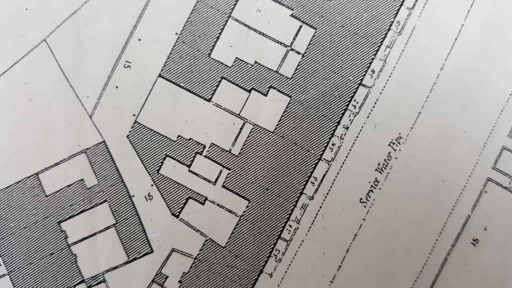
5 1 st Edition Ordnance Survey Map, Sheet 9 Scale: 1:1056 Surveyed , Published st Edition Ordnance Survey Map, Sheet 9 Scale: 1:1056 Surveyed , Published 1847

6 2 nd Edition Ordnance Survey Map, Sheet Scale: 1:1056 Surveyed 1889, Published 1889 Significance/NIAH Rating: The National Inventory of Architectural Heritage (NIAH) has been carried out for this area. The NIAH uses eight categories of special interest (architectural, historical, archaeological, artistic, cultural, scientific, technical & social) and identifies five categories of rating in seeking to rank buildings. The NIAH rating values are International, National, Regional, Local and Record Only (I, N, R, L, O). Structures which are considered of International, National, and Regional significance are deemed worthy of inclusion on the RPS. Ministerial Recommendations have not yet been issued for this section of Amiens Street, however the draft survey has assigned 55 Amiens Street a Regional rating. These are structures or sites that make a significant contribution to the architectural heritage within their region or area. The NIAH states the following in relation to the building: Amiens Street, formerly The Strand, was renamed in memory of Viscount Amiens, Earl of Aldborough, whose mansion is located on nearby Portland Row. This terraced house, one of a pair, on the northern side of Amiens Street appears to have been constructed during the late nineteenth century. The facade's machine-cut brick, typical of the time, represents the advances in building technology of the Victorian period. Such brick, with its smooth and uniform finish, could be produced quickly and on a mass scale. This differed greatly from the production of handmade bricks which had been used in construction before that age. The house and its pair have modest timber shopfronts, which are becoming a rare feature in a rapidly changing city. The NIAH have assigned a date of 1890, however on the basis of the historical research above it is likely that the building is much earlier and was refaced with modern red brick in the late 19 th century.
7 Assessment of Special Interest under the Planning & Development Act 2000 (identified by the NIAH) Architectural: Late 18 th century building with 19 th century shop to ground floor and living accommodation above. This building retains its modest shop front and timber sash windows which are becoming a rare feature in a rapidly changing city. It contributes to the character of the surrounding built environment. Historical: Tom Clarke, Irish Nationalist operated a shop in the building between circa 1909 and Tom Clarke ( ) was born in the Isle of Wight and educated in Dungannon. He was arrested on a Fenian bombing mission to London in 1883 and spent 15 years in prison. After a period in New York, he returned to Ireland in 1907 and helped reinvigorate the IRB and played a critical role in steering it towards insurrection. He was the first signatory of the 1916 Proclamation of the Republic and was in the GPO during Easter week. He was executed 3 May Conclusion & Recommendation: 55 Amiens Street is considered to be of Regional significance. It is therefore recommended that 55 Amiens Street, Dublin 1 be added to the Record of Protected Structures in accordance with Section 54 and 55 of the Planning and Development Act, Recommendation Proposed Entry 55 Amiens Street, Dublin 1 Paraic Fallon Senior Planner Date


8 Extent of Protected Structure Status Extent of proposed protection for 55 Amiens Street is shown on the map below outlined in red. Photographic Record: External: Figure 1: Front elevation of 55 Amiens Street


9 Figure 2: 55 Amiens Street in terrace of buildings Figure 3: Detail of two shopfronts on ground floor front elevation Figure 4: Detail of doors on front elevation of building Figure 5: Detail of consile bracket on shopfront


10 Figure 6: View of fascia of shopfront and missing cornice and console brakets Figure 7: View of granite paving slab at front site of building Figure 8: Detail of first floor front elevation window6


11 Figure 9: First floor front elevation windows Figure 10: Yellowbrick chimneystack on northeast end of roof Figure 11: View of upper levels of rear elevation


12 Figure 12: View of rear elevation and rear site of structure Figure 13: View of rear elevation and rear lane
20th of April To the Chairperson and Members of the South East Area Committee
 Conservation Section, Property, Enterprise & Economic Development Department Civic Offices, Wood Quay, Dublin 8 An Rannóg Caomhantais, An Roinn Phleanála, Maoine, Fiontraíochta & Forbairt Eacnamaíochta
The current entry reads RPS Address Description 5026 Marlborough Street, Dublin 1 Training College (Department of Education) and gate lodge
 and gate lodge") Conservation Section, Property, Enterprise & Economic Development Department Civic Offices, Wood Quay, Dublin 8 An Rannóg Caomhantais, An Roinn Phleanála, Maoine, Fiontraíochta & Forbairt Eacnamaíochta
Conservation Section, Property, Enterprise & Economic Development Department Civic Offices, Wood Quay, Dublin 8 An Rannóg Caomhantais, An Roinn Phleanála, Maoine, Fiontraíochta & Forbairt Eacnamaíochta
Date: 08/03/18. To the Chairperson and Members of the Central Area Committee
 Conservation Section, Planning & Property Development Department Civic Offices, Wood Quay, Dublin 8 An Rannóg Caomhantais, An Roinn Pleanála & Forbairt Maoine Oifigí na Cathrach, An Ché Adhmaid, Baile
STRENSALL RAILWAY BUILDINGS CONSERVATION AREA APPRAISAL. In association with Strensall with Towthorpe Parish Council
 STRENSALL RAILWAY BUILDINGS CONSERVATION AREA APPRAISAL In association with Strensall with Towthorpe Parish Council CONTENTS Page 1 Introduction 2 2 Location and Context 3 3 Topography and Setting 4 4
Friends Meeting House, Broughton. Meeting House Lane, Little Broughton, Cockermouth, CA13 0YQ. National Grid Reference: NY
 Friends Meeting House, Broughton Meeting House Lane, Little Broughton, Cockermouth, CA13 0YQ National Grid Reference: NY 07832 31740 Statement of Significance The modest building has medium significance
2154 Dundas Street West Intention to Designate under Part IV, Section 29 of the Ontario Heritage Act
 STAFF REPORT ACTION REQUIRED 2154 Dundas Street West Intention to Designate under Part IV, Section 29 of the Ontario Heritage Act Date: February 2, 2009 To: From: Toronto Preservation Board Toronto and
CHAIR AND MEMBERS PLANNING & ENVIRONMENT COMMITTEE MEETING ON MONDAY AUGUST 28, 2017 JOHN M. FLEMING MANAGING DIRECTOR, PLANNING AND CITY PLANNER
 TO: FROM: SUBJECT: CHAIR AND MEMBERS PLANNING & ENVIRONMENT COMMITTEE MEETING ON MONDAY AUGUST 28, 2017 JOHN M. FLEMING MANAGING DIRECTOR, PLANNING AND CITY PLANNER REQUEST FOR DEMOLITION OF HERITAGE LISTED
Heritage Property 70 Liberty Street (Central Prison Chapel)
") STAFF REPORT ACTION REQUIRED Alteration of a Designated Heritage Property 70 East Liberty Street (Central Prison Chapel) Date: October 9, 2012 To: Toronto Preservation Board Toronto East York Community
STAFF REPORT ACTION REQUIRED Alteration of a Designated Heritage Property 70 East Liberty Street (Central Prison Chapel) Date: October 9, 2012 To: Toronto Preservation Board Toronto East York Community
Conservation Area Designation, amendments and Review
 Conservation Area Designation, amendments and Review Location: No.s 37-49 (odd) Twickenham Road Date Assessed: January 2018 Adjacent Conservation Area Significance: Teddington Lock CA. The Teddington Lock
Exploring Abergavenny
 11 Majors Barn36 Ysguborwen Exploring Abergavenny 2 ysguborwen EXPLORING ABERGAVENNY For several years the Abergavenny and District Civic Society has been studying the streets, spaces and buildings of
Historical Value As evidence of Quaker heritage in Wells extending over three hundred years, the meeting house has high historical value.
 Friends Meeting House, Wells-next-the-Sea Quaker Yard, Church Street, Wells-next-the-Sea, Norfolk, NR23 1HZ National Grid Reference: TF 91978 43092 Statement of Significance The building has high significance
Character Area 1: Town Core
 Character Area 1: Town Core Map S 354 Copyright Cotswold District Council 109 Character Area 1: Town Core Key Characteristics 355 356 357 358 359 360 361 362 363 364 365 366 367 368 369 370 Copyright Cotswold
Character Area 9. Residential: South West
 Lancaster Conservation Area Appraisal Character Area 9. Residential: South West March 2013 128 3.9 Character Area 9. Residential: South West 3.9.1. Definition of Special Interest "This character area is
Commercial Building Cuba Street. Images: Charles Collins, Summary of heritage significance
 Commercial Building 221-225 Cuba Street Summary of heritage significance Images: Charles Collins, 2014 221-225 Cuba Street is the remnant façade of an 1896 row of three two-storey shop/dwellings and is
Purpose of the Variation: The purpose of an ACA is to protect and enhance the special character of the ACA by:
 To the Lord Mayor and Report No. 202/2017 Members of Dublin City Council Report of the Assistant Chief Executive Proposed Draft Variation (No. 2) of Dublin City Development Plan 2016 2022 Designating Hollybrook
GREAT WESTERN SQUARE & ENVIRONS
 GREAT WESTERN SQUARE & ENVIRONS Draft Architectural Conservation Area Report Character Appraisal and Policy Framework 20 1 Architectural Conservation Area Report: GREAT WESTERN SQUARE & ENVIRONS Draft
Ordnance Street 110 Plan OS Lot 413 B202; parts of Lot 412 and portion of Lot 413
 Ordnance Street 110 Plan OS Lot 413 B202; parts of Lot 412 and portion of Lot 413 110 Ordnance Street has cultural heritage value under 3 categories Physical built in 1886, it is an example of late 19
Architectural Inventory Form (page 1 of 5)
") OAHP1403 Rev. 9/98 COLORADO CULTURAL RESOURCE SURVEY (page 1 of 5) Official eligibility determination (OAHP use only) Date Initials Determined Eligible- NR Determined Not Eligible- NR Determined Eligible-
OAHP1403 Rev. 9/98 COLORADO CULTURAL RESOURCE SURVEY (page 1 of 5) Official eligibility determination (OAHP use only) Date Initials Determined Eligible- NR Determined Not Eligible- NR Determined Eligible-
17. Coolaney-Rockfield Mini-Plan
 County Development Plan 2017-2023 Consolidated Draft + Adopted Amendments - August 2017 17. Coolaney-Rockfield Mini-Plan Village profile Coolaney is located approximately 23 km to the south-west of Sligo
68 Tressillian Road SE4 1YD. Design and Access Statement. 19th January Single-storey rear extension
 68 Tressillian Road SE4 1YD Single-storey rear extension Design and Access Statement Design and Access Statement For a single-storey rear extension This design and access statement is prepared by Wylie
Built in 1984, the meeting house is the third meeting house on a site acquired in 1668 as a burial ground. The building has low heritage significance.
 Friends Meeting House, Reigate 47 Reigate Road, Reigate, Surrey, RH2 0QT National Grid Reference: TQ 26184 50219 Statement of Significance Built in 1984, the meeting house is the third meeting house on
Historical value The building is a rare example of a small, little altered meeting house of the eighteenth century. It has high historical value.
 Friends Meeting House, Wallingford 13 Castle Street, Wallingford, Oxfordshire, OX10 8DL National Grid Reference: SU 60702 89627 Statement of Significance The meeting house is a small brick building of
Appendix 1: Site Inventory Form
 Appendix 1: Site Inventory Form Wapsi Valley Archaeology, Inc. Anamosa, IA 56 X Cemetery Washington 83 24 2 NE X 1 5 approx. 200 approx. 201 unknown unknown Historic Resources Evaluation: 07A: Cemetery
Evidential value The meeting house site is likely to have low archaeological potential and the building has low evidential value.
 Friends Meeting House, Colwyn Bay 21 Erskine Road, Colwyn Bay, LL29 8EU National Grid Reference: SH 85406 78739 Statement of Significance The 1899 meeting house is an attractive late Victorian building
Historic Resources Inventory Evaluation Form
 Evaluation Date September 12, 2017 Historic Resources Inventory Evaluation Form Community District Designation Downtown Grade 1 The place should be rated for each of the criteria below, in order to establish
26 Park West Exploring Abergavenny
 26 Park West Exploring Abergavenny Cover: Park Avenue 2 park west EXPLORING ABERGAVENNY For several years the Abergavenny and District Civic Society has been studying the streets, spaces and buildings
Friends Meeting House, Oakham. 59 South Street, Oakham, LE15 6BG. National Grid Reference: SK Statement of Significance
 Friends Meeting House, Oakham 59 South Street, Oakham, LE15 6BG National Grid Reference: SK 85941 08691 Statement of Significance An attractive simple building of the early eighteenth century, with an
Eastern Golf Course, Doncaster Road, Doncaster
 , 463-535 Road, Heritage Assessment in accordance with Schedule to the Development Plan Overlay July 2013 bryce raworth conservation urban design 19 Victoria Street St Kilda Vic 3182 , 463-535 Road, Heritage
Birr Town Record of Protected Structures
 14819098 14935004 14819250 14819191 14819234 14819236 14819189 14819125 148192912 14819233 14819237 14819067 14819004 14819006 14819275 14819222 14819231 14819102 14819267 14819261 14819203 14819232 14820003
Morgan s Subdivision Historic District Character-defining Features
 Morgan s Subdivision Historic District Character-defining Features DISTRICT DESCRIPTION This small addition, designed as a neighborhood for those wishing to move east from Capitol Hill, was predominantly
ST. LUKE'S. planning consent will not be given for residential uses of ground floor and basement premises currently in non-residential use;
 CA SIXTEEN ST. LUKE'S 16.1 The Council will operate special policies in the St. Luke s Conservation Area in order to preserve and enhance the special character and appearance of the area. 16.2 Lying in
Purpose of the Variation: The purpose of an ACA is to protect and enhance the special character of the ACA by:
 To the Lord Mayor and Report No. 201/2017 Members of Dublin City Council Report of the Assistant Chief Executive Proposed Draft Variation (No. 1) of Dublin City Development Plan 2016 2022 Designating Haddon
Appraisal of proposed alterations to the boundary of Helmsley Conservation Area
 Appraisal of proposed alterations to the boundary of Helmsley Conservation Area Elmslac Road: Elmslac Road was constructed in the early 1950s in two or three stages by the Helmsley Rural District Council.
8. Camberwell 8.1. Camberwell Area Vision
 8. 8.1. Area Vision 8.1.1. is: Centred on a medieval village centre which has become a thriving modern town centre surrounded by residential streets laid out in the Georgian era; Linked by rail to central
2bPlanning Scheme. Appendix. Conservation - Removal of Structures. Grangegorman
 Appendix 2bPlanning Scheme Grangegorman Conservation - Removal of Structures Innovative Urban Quarter Contemporary Healthcare Facilities Modern Education Hub Accessible Public Spaces Appendix 2b: Purpose
Architectural Inventory Form
 COLORADO CULTURAL RESOURCE SURVEY Page 1 of 8 Official Eligibility Determination (OAHP use only) Rev. 9/98 OAHP1403 Date Initials Determined Eligible National Register Determined Not Eligible National
Houses on the Forest Edge
 Houses on the Forest Edge Vivien Hill 1 Contents 3 Introduction 4 Pavilion Cottages 5 Oak Tree Cottage 6 Arts and Crafts Style 7 Laura House 8 Hillview 9 Bryle House 10 William Wells and the 1851 Census
Toronto Preservation Board Toronto and East York Community Council. Director, Policy and Research, City Planning Division
 STAFF REPORT ACTION REQUIRED 104 John Street - Alteration to a Heritage Property and Intention to Designate, Part IV, Section 29, Ontario Heritage Act and Authority to Enter Into a Heritage Easement Agreement
Address: 302 West Main Street PIN: Plan: Rectangular Stories: 2 Original Owner: Roof Type: Flat
 D 01 1 Address: 302 West Main Street PIN: 21 11 400 014 Plan: Rectangular Stories: 2 Building Names: Important Dates: ca 1920 Walls: BRICK Architectural Style: American, Late 19th / Early 20th C: Commercial
7.1 Area 1: Haslemere Conservation Area
 7.1 Area 1: Haslemere Conservation Area Detailed map of Haslemere Town Conservation Area as of 2006 Crown copyright and database right 2011 Ordnance Survey LA100025451 27 The Conservation Area is characterised
7.0 NATIONAL WINE CENTRE
 91 7.0 NATIONAL WINE CENTRE 7.1 Description of Campus The National Wine Centre Campus is located on the south eastern corner of the Botanic Gardens. It occupies a site originally used for the Lunatic Asylum
35. Gorteen Mini-Plan
 35. Gorteen Mini-Plan 35. Gorteen Mini-Plan Community facilities Community facilities in Gorteen consist of a crèche, community centre, sports field, church, burial ground and health centre. The former
Chapter 2, Section C: Urban Design and Visual Resources A. INTRODUCTION
 Chapter 2, Section C: Urban Design and Visual Resources A. INTRODUCTION This attachment considers the potential of the proposed East River Waterfront Access Project at Peck Slip to effect urban design
The Director of Development Planning and Manager of Urban Design and Cultural Heritage recommends:
 HERITAGE VAUGHAN COMMITTEE APRIL 26, 2017 LOT LINE ADJUSTMENT AND DEMOLITION OF GARAGE 376 STEGMAN S MILL ROAD - KLEINBURG-NASHVILLE HERITAGE CONSERVATION DISTRICT, DESIGNATED UNDER PART V, ONTARIO HERITAGE
429 Lansdowne Road Building or Property Name. Original owner
 HERITAGE SURVEY AND EVALUATION FORM Municipal Address 429 Lansdowne Road Building or Property Name 042280293 Legal Description PLAN 92 PT BLK 13 JUNC GORE;PT LOT 1 RP4R8942 PART 1 Lot Block Plan Date of
Conservation Area Designation, amendments and Review
 Conservation Area Designation, amendments and Review Location: Are area largely confined to Cowley Road and North Warpole Way and incorporating the following properties: No.s 2-120 (even) & 61 123 (odd)
CHAIR AND MEMBERS PLANNING AND ENVIRONMENT COMMITTEE ON TUESDAY MARCH 29, 2016
 TO: FROM: SUBJECT: CHAIR AND MEMBERS PLANNING AND ENVIRONMENT COMMITTEE ON TUESDAY MARCH 29, 2016 JOHN M. FLEMING MANAGING DIRECTOR, PLANNING AND CITY PLANNER DESIGNATION OF 864-872 DUNDAS STREET UNDER
County Development Plan Consolidated Draft + Adopted Amendments August 2017 Volume 2, Chapter 22 Easky Mini-Plan
 22. Easky Mini-Plan Village profile Easky is a coastal settlement located approximately 40 km to the west of Sligo City, in a designated Rural Area In Need of Regeneration. The nearby coastline is designated
2.6 City Centre District Site Specific Design Recommendations
 20 2.6 City Centre District Site Specific Design Recommendations The following section identifies specific design recommendations for every storefront and façade: 67 King Street East 21 Benton Street Introduce
Baker Historic District
 DISTRICT DESCRIPTION This is a historically middle-class neighborhood in the South Side, an area annexed by Denver in 1883, consisting of more than 20 tightly interwoven residential subdivisions. The earliest
Chapter 8: BEACH SOUTH OF ATLANTIC AVENUE NEIGHBORHOOD PLANNING AREA ANALYSIS
 Chapter 8: BEACH SOUTH OF ATLANTIC AVENUE NEIGHBORHOOD PLANNING AREA ANALYSIS The Beach South of Atlantic Avenue Neighborhood Planning Area includes the parcels adjacent to S Fletcher Avenue from Atlantic
Friends Meeting House, Norwich. Upper Goat Lane, Norwich, Norfolk, NR2 1EW. National Grid Reference: TG Statement of Significance
 Friends Meeting House, Norwich Upper Goat Lane, Norwich, Norfolk, NR2 1EW National Grid Reference: TG 22802 08656 Statement of Significance The meeting house has exceptional heritage significance as a
Artists impression of the Park Promenade and plot H4 with café and restaurant uses that is still subject to change
 The Park Promenade Artists impression of how a café might look Artists impression of the Park Promenade and plot H4 with café and restaurant uses that is still subject to change Precedent images for balconies
2.11 PARAPETS AND CORNICES
 2.11 PARAPETS AND CORNICES Parapets and cornices mark the transition between buildings and the sky; they cap the building and conceal the roof. Parapets often extend well above the roof to create an illusion
Derry City and Strabane District Council Planning Committee Report
 Derry City and Strabane District Council Planning Committee Report COMMITTEE DATE: 3 rd June 2015 APPLICATION No: A/2015/0098/F APPLICATION TYPE: Full PROPOSAL: Change of use from 7 bed residential property
PLANNING COMMITTEE. 14 October 2014
 AGENDA ITEM NO 8 PLANNING COMMITTEE 14 October 2014 APPLICATION NUMBER : CA//14/01744/FUL PROPOSAL : Extension and conversion of roof space of an existing detached bungalow together with enhanced parking
Ottawa Historic Resources Inventory: Commercial Historic District Building Information. Significance and Potential Eligibility
 C 01 1 Address: address 1 PIN: 21 11 218 001 Plan: Rectangular Stories: 2 Original Owner: Roof Type: Flat Building Names: Marquette School Foundation: Important Dates: ca 1955 Walls: BRICK Architect /
Herne Bay. Parsonage Road, Herne Bay, Kent, CT6 5TA 545,000
 Herne Bay Parsonage Road, Herne Bay, Kent, CT6 5TA 545,000 Staveley Lodge is an utterly beautiful and imposing Edwardian property, tucked away within a private un-adopted cul-de-sac of prestigious period
DACORUM GOLDEN PARSONAGE Great Gaddesden Brief Description Principal Building: Approach: Stable block other utilitarian buildings: Walled Garden:
 HERTFORDSHIRE GARDENS TRUST LOCAL LIST: DACORUM Present Name of Site GOLDEN PARSONAGE Historic Name (if known) Parish/Town Great Gaddesden National Grid Reference of Principal Building: TL051 125 Present
Architectural Inventory Form
 COLORADO CULTURAL RESOURCE SURVEY Page 1 of 8 Official Eligibility Determination (OAHP use only) Rev. 9/98 OAHP1403 Date Initials Determined Eligible National Register Determined Not Eligible National
Lenoir Downtown National Register Historic District Christmas Ornament Series
 Lenoir Downtown National Register Historic District Christmas Ornament Series 828-757-2177 www.cityoflenoir.com 2008 The Clock on the Square The prominence of street clocks parallels the growth of American
This property contributes to the historic streetscape of Colborne Street and its striking architecture makes it a landmark along the street.
 Exhibit B Notice of Intention to Pass a By-Law to Designate 25 Colborne Street, also known as the Clark Wright House, To be of Cultural Heritage Value and Interest Pursuant to the Provisions of the Ontario
List of Buildings of Local Architectural or Historic Interest BUCKHURST HILL PARISH
 List of Buildings of Local Architectural or Historic Interest BUCKHURST HILL PARISH 1. ST. STEPHEN'S CHURCH Albert Road /Buckhurst Way Attractive, albeit modest, late 19th century church (date stone 1876)
Character Appraisal Zone 1: Charlotteville. i Topography, Views and Vistas
 Conservation Area Study and 3 Zone 1: Charlotteville For boundaries, please refer to Map 2 in the Appendices at the rear of this document. Charlotteville has a strong identity distinct from other parts
King-Spadina HCD Study
 King-Spadina HCD Study Community Meeting #2 March 18, 2014 City of Toronto Taylor Hazell Architects Ltd. Urban Strategies ASI Welcome Thank you for attending the second community meeting for the King-Spadina
Theosophical Society Hall
 Theosophical Society Hall 19 Marion Street Image: Charles Collins, 2015 Summary of heritage significance This hall has been used continuously since its construction in 1918 by the Theosophical Society,
Lincoln Townscape Assessment. Central Station Inherited Character Area Statement
 Lincoln Townscape Assessment Central Station Inherited Character Area Statement JULY 2008 Page 2 of 16 Table of Contents Page Overview 2 Historical Development 3 Urban form 4 Views 9 Condition of Buildings
DESIGN & ACCESS STATEMENT
 . DESIGN & ACCESS STATEMENT Site Adjacent to The Manor House, Upper Street,, Kingsdown, Deal, Kent. DESIGNS ARCHITECTURE + PLANNING CONTENTS Design and Access Statement Introduction Site and Location Planning
Historic England Advice Report 26 August 2016
 Case Name: Kingsland Castle Case Number: 1435892 Background Historic England has been asked to review the scheduling for Kingsland Castle. The land on which the monument lies is understood to be for sale.
Demolition of a Designated Heritage Property Roncesvalles Avenue
 REPORT FOR ACTION Demolition of a Designated Heritage Property - 421 Roncesvalles Avenue Date: March 8, 2018 To: Toronto Preservation Board Toronto and East York Community Council From: Acting Chief Planner
IMPORTANT NOTICE. Architectural Inventory Form COLORADO CULTURAL RESOURCE SURVEY I. IDENTIFICATION th Street 5WL.5601
 IMPORTANT NOTICE OAHP1403 Rev. 9/98 COLORADO CULTURAL RESOURCE SURVEY Architectural Inventory Form Page 1 This survey form represents an UNOFFICIAL COPY and is provided for informational purposes only.
HISTORIC SITE FORM - HISTORIC SITES INVENTORY PARK CITY MUNICIPAL CORPORATION (10-08) 1 IDENTIFICATION
 1 IDENTIFICATION") HISTORIC SITE FORM - HISTORIC SITES INVENTORY PARK CITY MUNICIPAL CORPORATION (10-08) 1 IDENTIFICATION Name of Property: Address: 164 Sandridge Road AKA: City, County: Park City, Summit County, Utah Tax
HISTORIC SITE FORM - HISTORIC SITES INVENTORY PARK CITY MUNICIPAL CORPORATION (10-08) 1 IDENTIFICATION Name of Property: Address: 164 Sandridge Road AKA: City, County: Park City, Summit County, Utah Tax
Plean Forbairt Development Plan
 1 COMHAIRLE THOGHLACH DHROICEAD ATHA DROGHEDA BOROUGH COUNCIL Plean Forbairt 2005 2011 Development Plan 2005-2011 2 Project Team: Planning Terence Savage: Senior Executive Planner (Acting) - Drogheda Borough
DARTMOUTH SQUARE AND ENVIRONS
 DARTMOUTH SQUARE AND ENVIRONS 1.0 Introduction / Location Dartmouth Square is located due south of Grand Parade and midway between Ranelagh Road and Lesson Street Upper, approximately 2km south of the
M E M O R A N D U M PLANNING AND COMMUNITY DEVELOPMENT DEPARTMENT CITY OF SANTA MONICA PLANNING DIVISION
 M E M O R A N D U M 10-B PLANNING AND COMMUNITY DEVELOPMENT DEPARTMENT CITY OF SANTA MONICA PLANNING DIVISION DATE: April 9, 2018 TO: FROM: SUBJECT: The Honorable Landmarks Commission Planning Staff 133
Lancaster Conservation Area Appraisal. Character Area 8. Cathedral
 Lancaster Conservation Area Appraisal Character Area 8. Cathedral March 2013 118 3.8 Character Area 8. Cathedral 3.8.1. Definition of Special Interest "This character area is distinctive for the fine group
Land Adj. 63 Sunny Bank Road, Sutton Coldfield, Birmingham, B73 5RJ
 Committee Date: 11/07/2013 Application Number: 2013/03520/PA Accepted: 20/05/2013 Application Type: Full Planning Target Date: 15/07/2013 Ward: Sutton Vesey Land Adj. 63 Sunny Bank Road, Sutton Coldfield,
6. Bermondsey 6.1. Bermondsey Area Vision
 6. 6.1. Area Vision 6.1.1. is: An inner-london neighbourhood characterised by modest worker ho associated with the historic Rotherhithe docks and local manufacturing industries such as biscuits, jam, vinegar
EXCELSIOR SPRINGS HISTORIC RESOURCES 10
 EXCELSIOR SPRINGS HISTORIC RESOURCES 10 Resource No. 1. Property name, present Springdale Apartments 6. Location Map Property name, historic Arlington Hotel; Excelsior Club; Excelsior Springs Sanitarium
Conservation Area Designation, amendments and Review
 Conservation Area Designation, amendments and Review Location: Any area largely confined to Park Road and St. James Avenue which includes the following properties: St. James Church, St. James Road; No.
DESIGN AND ACCESS STATEMENT NEW TALYBONT HALLS, CARDIFF UNIVERSITY JULY 2018
 DESIGN AND ACCESS STATEMENT NEW TALYBONT HALLS, CARDIFF UNIVERSITY JULY 2018 1 FILE NTHCU-STL-XX-XX-RP-A-9075-RP013 PROJECT New Talybont Halls, Cardiff University CLIENT Cardiff University STRIDE TREGLOWN
Lincoln Townscape Assessment. Sherbrooke Inherited Character Area Statement
 Lincoln Townscape Assessment Sherbrooke Inherited Character Area Statement June 2008 Page 2 of 15 Table of Contents Page Overview 2 Historical Development 3 Urban form 4 Views 8 Condition of Buildings
SCHEDULE 12 TO THE DESIGN AND DEVELOPMENT OVERLAY GLEN WAVERLEY ACTIVITY CENTRE STRUCTURE PLAN
 DD/MM/YY Proposed C120 SCHEDULE 12 TO THE DESIGN AND DEVELOPMENT OVERLAY Shown on the planning scheme map as DDO12. GLEN WAVERLEY ACTIVITY CENTRE STRUCTURE PLAN 1.0 Design objectives DD/MM/YY Proposed
10 Glan Gavenny. Exploring Abergavenny
 10 Glan Gavenny Exploring Abergavenny EXPLORING ABERGAVENNY For several years the Abergavenny and District Civic Society has been studying the streets, spaces and buildings of Abergavenny and Mardy outside
COWES CONSERVATION AREA REVISION - NORTHWOOD PARK CHARACTER AREA
 COWES CONSERVATION AREA REVISION - NORTHWOOD PARK CHARACTER AREA AS APPROVED BY EXECUTIVE The legal background Section 69 of the Planning (Listed Buildings and Conservation Areas) Act 1990 imposes a duty
6. Ballintogher Mini-Plan
 County Development Plan 2017-2023 Consolidated Draft + Adopted Amendments August 2017 Volume 2, Chapter 6 Ballintogher Mini-Plan 6. Ballintogher Mini-Plan Village profile Ballintogher is located approximately
Architectural Inventory Form
 IMPORTANT NOTICE OAHP1403 Rev. 9/98 COLORADO CULTURAL RESOURCE SURVEY Page 1 This survey form represents a only. All information, particularly determinations of eligibility for the National Register, the
Warren Farm, Ampthill
 1 Welcome The developers of the Warren Farm site, Bloor Homes and Connolly Homes, are holding this exhibition on the emerging Design Codes for the development prior to their formal submission to Central
30. Riverstown Mini-Plan
 County Development Plan 2017-2023 Consolidated Draft + Adopted Amendments August 2017 Volume 2, Chapter 30 Riverstown Mini-Plan 30. Riverstown Mini-Plan Village profile Riverstown is located approximately
URBAN DESIGN BRIEF 181 Burloak Drive, Oakville
 URBAN DESIGN BRIEF 181 Burloak Drive, Oakville February 2017 Our File: 1730B 230-7050 WESTON ROAD / WOODBRIDGE / ONTARIO / L4L 8G7 / T: 905 761 5588/ F: 905 761 5589/WWW.MHBCPLAN.COM TABLE OF CONTENTS
Proposed Illustrative Masterplan Cumulative Revised Proposals. Properties
 Proposed Illustrative Masterplan Cumulative Revised Proposals Earls Court Project Application 2 Royal Borough of Kensington & Chelsea Environmental Statement, Volume II - Site Wide Development Option -
CHESHIRE HISTORIC TOWNS SURVEY
 CHESHIRE HISTORIC TOWNS SURVEY Frodsham Archaeological Strategy 2003 CHESHIRE HISTORIC TOWNS SURVEY Frodsham Archaeological Strategy 2003 Environmental Planning Cheshire County Council Backford Hall Backford
Gillingham Hall Norfolk
 Gillingham Hall Norfolk Figure 1. Engraving after a drawing by J S Cotman 1818 Impact assessment of proposed alterations NHER No. 10738 Stephen Heywood FSA Heritage and Landscape Norfolk County Council
APPENDIX 9 HERITAGE CHARACTER
 APPENDIX 9 HERITAGE CHARACTER Defining attributes and features Perth Official Plan Appendix 9 HERITAGE CHARACTER defining attributes and features This appendix includes a table describing heritage attributes
Project Design and Access Statement: Rev B - Proposed replacement of the Clubhouse and Golf Shop at Hawkstone Park.
 Project 17-451 Design and Access Statement: Rev B - Proposed replacement of the Clubhouse and Golf Shop at Hawkstone Park. Prepared By: Gary Johns Architects 1.0 Contents: 2.0 Introduction 3.0 Proposed
The Manager of Urban Design and Cultural Heritage recommends:
 HERITAGE VAUGHAN COMMITTEE FEBRUARY 17, 2016 1. PROPOSED RENOVATIONS AND ADDITION TO 8006 KIPLING AVENUE IN WOODBRIDGE HERITAGE CONSERVATION DISTRICT, REVISIONS TO PREVIOUS PROPOSAL WARD 2 - VICINITY OF
KING-SPADINA COMMERCIAL HERITAGE CONSERVATION DISTRICT PLAN COMMUNITY CONSULTATION MEETING #1
 KING-SPADINA COMMERCIAL HERITAGE CONSERVATION DISTRICT PLAN 1 TUESDAY, APRIL 21, 2015 METRO HALL, ROOM 308/309 55 JOHN STREET, TORONTO 6:30 7:00 Open House 7:00 7:15 Remarks Councillor Cressy Heritage
Character Area 6. Canal Corridor: South
 Character Area 6. Canal Corridor: South March 2013 98 3.6 Character Area 6. Canal Corridor South 3.6.1. Definition of Special Interest "The character of this area is defined by a group of large, significant
Chapter 7 Route window W20 Dover Road and Leigh Road bridges. Transport for London
 Chapter 7 Route window W20 Dover Road and Leigh Road bridges Transport for London ROUTE WINDOW W20 7 Route window W20 Dover Road and Leigh Road bridges Transport for London 7.6 7.7 7.8 Baseline conditions
Barber Shop Or Hair Salon; Commercial Block; Hotel or Inn; Market or Grocery Store
 Inventory No: Historic Name: Common Name: Address: NWB.1685 Smith, Justin and Rufus Grocery Store - Adams Hous Hennessy, Thomas Fruit Market 36-38 Market Sq City/Town: Village/Neighborhood: Local No: 4-40