TRANSIT CENTER DISTRICT PLAN
|
|
|
- Warren Alexander
- 5 years ago
- Views:
Transcription

1 TRANSIT CENTER DISTRICT PLAN Public Workshop #3: Quality of Place San Francisco Planning Department In partnership with: San Francisco Redevelopment Agency Transbay Joint Powers Authority
2 Transit Center District Plan Area Private and Public parcels around Transit Center, including Transbay Redevelopment Area Zone 2
3 Transit Center District Plan Objectives Environmentally Responsible Land Use: Capitalize on new major transit investment with appropriate land use response in the downtown core Building on the Urban Design Element and Downtown Plan: Analyze the downtown form Identify opportunities and set guidelines and standards to build a high-quality public realm and provide public amenities Generate more revenue to support the Transbay Transit Center/Caltrain Caltrain Extension project and other public benefits.

4 Current Urban Form proposal

5 Conceptual Illustration Only Twin Peaks: 1,000

6 Dolores Park: 1,000 Conceptual Illustration Only

7 Urban Potrero Form/Shadow Hill: 1,000 Analaysis Conceptual Illustration Only

8 Opportunity Site Analysis
9 Buildout Potential Net Additional Space Increment over Existing Zoning Office Space 5.82 million gsf million gsf Housing Units 1, Hotel Rooms 1, Retail Space 85,000 gsf -- Total Space 9.2 million gsf million gsf
10 Tonight s s Topics 1. Land Use/Zoning 2. Building Design 3. Open Space 4. Historic Resources 5. Sustainability
11 Land Use/ Zoning

12 Existing Zoning Zoning Plan area mixture of C-3-O and C-3-O(SD)
13 Zoning Draft Proposed Zoning Reclassify all of Plan area to C-3-O(SD)
14 Floor Area Ratio (FAR) Goals: Do not limit the density of development in this transit hub, but ensure that offsetting public infrastructure and benefits are captured for increased densities. Draft Controls: Eliminate 18:1 cap on FAR in C-3-O(SD) district Balance public benefit of increased FARs above base allowance (6:1)among varied public benefits: Historic Preservation (TDR) Transit Center funding Transportation and other mitigations Streetscape Public Space
15 Land Use If capacity is largely reserved for office space where currently permitted... There is almost enough capacity to meet Baseline office demand through 2035, but There is a significant shortfall in meeting Smart Growth scenario. There is more than sufficient planned and zoned capacity Downtown to meet housing projections through 2035.
16 Land Use: Zoning Goals: Reserve bulk of space in core Transit District for downtown job growth Limit amount of non-commercial uses on major opportunity sites, while permitting mixed-use (e.g. office with housing or hotel) in large buildings and permitting buildings without commercial uses on smaller sites Seek to achieve an overall ratio in new construction in the district of 70% office/30% non-office (e.g. residential, hotel, cultural) Draft Control: Create Commercial Sub-district for part of the Plan area where major new projects (new construction greater than 7:1 FAR on sites larger than 10,000 sf) require at least 3 s.f. of commercial space for every 1 s.f. of residential, hotel, or cultural space.


17 Land Use: Zoning Proposed Commercial Sub-district

18 Ground Floor Uses: Active Retail Required Goal: On limited key street frontages, ensure continuous consumer retail (i.e. eating/drinking, shopping, personal service) and maximum diversity of businesses on the ground floor to create lively destination commercial areas. Draft Control: On ground floor frontages identified: Required ground floor retail Limited street frontage width of 50 per tenant Prohibit non-consumer uses (financial service, insurance, travel/real estate agency, gyms, medical, general office, education/institution) Discourage lobbies and service functions on these frontages


19 Ground Floor Uses: Active Retail Required
20 Active Uses: Transit Center Park Goal: Encourage active and public uses in adjacent buildings which activate the Transit Center Park. Draft Control: Create FAR exemption for any retail, community facilities, or publicly-accessible space provided at the level of the Transit Center rooftop park in adjacent buildings that is directly accessible by a footbridge from the park.
21 Public Realm: Building Design


22 Ground Floor Design: Active Spaces Expansive lobby frontages do not activate the street or contribute to an engaging pedestrian experience and can negatively dampen or discourage the life and character of the district.

 at the street face")


23 Ground Floor Design: Active Spaces Frontages where lobbies are minimized in width (but prominent) at the street face can be lined with active spaces, such as commercial uses and public space, create an engaging and exciting place to be and to walk.

24 Ground Floor Design: Active Spaces Goal: Ensure ground floors that are engaging to the pedestrian and enliven the street environment Draft Control: Limit the street frontage width of lobbies to that necessary for circulation and require them to be lined with publicoriented uses, including commercial uses and public open space.


25 Ground Floor Design Goal: Encourage tall and spacious ground floor spaces Control: Eliminate Floor Area Ratio penalty for tall floors. (Sec currently requires creating and counting phantom floors in square footage calculation where average floor-to-floor height exceeds 15 feet. This discourages gracious tall ground floor spaces.)

26 Ground Floor Design: Curb Cut Restrictions
27 Setbacks Where and Why? Achieve wider sidewalks where there are significant contiguous stretches of anticipated new development Example: North side of Folsom Street in Zone 1 Where and Why not? Conservation/Historic District and frontages with consistent streetwall at the property line Spotty or non-contiguous redevelopment of parcels that would not create consistent sufficient sidewalk width for pedestrian flow or consistency for streetscape treatments


28 Pedestrian Space and Streetscape Due to increased development and the Transit Center project, there will be a major increase in pedestrian volumes throughout the district, not just at a couple locations adjacent to new buildings


29 Pedestrian Space and Streetscape and the sidewalks are barren of landscaping and pedestrian amenities throughout the area, and not wide enough to accommodate increases in pedestrian traffic and consistent corridor-length streetscape improvements.


30 Pedestrian Space and Streetscape

31 Setbacks In the Plan area, future development is generally spotty and non-contiguous, with much recent development, and many historic buildings therefore building setbacks are not a practical strategy district-wide to achieve the needed consistent corridor-length sidewalk widths for pedestrian volumes and streetscape improvements. Goal: Pursue building setbacks to augment a sidewalk widening program on street frontages where there are significant stretches of parcels likely to be redeveloped in key locations. Likely opportunity Sites
 West side of 1 st Street between Market and Mission Streets Setback must be designed as an extension of the")
32 Setbacks Draft Control: 10 building setback required on the following frontages: North side of Mission Street between 1 st and 2 nd Streets North side of Howard Street between 1 st Street and 2 nd Street South side of Mission Street between 1 st and Fremont Streets (Transit Tower) West side of 1 st Street between Market and Mission Streets Setback must be designed as an extension of the sidewalk: at sidewalk grade completely free of all columns or other building elements be open at all times for pedestrian circulation


33 Arcades and Sidewalks Why not create arcades? Arcades generally are not successful, as they don t feel and function like an extension of the sidewalk. Arcades tend to deaden the sidewalk environment by withdrawing the building ground floor away from the sidewalk and behind a line of columns. Pedestrians typically don t use arcades for movement, only for accessing that immediate building, or if there is no choice.

34 Streetwall and the Urban Room The Downtown Plan included policies recognizing the need to humanize and reduce the scale of tall buildings POLICY 16.1 Conserve the traditional street to building relationship that characterizes downtown San Francisco. POLICY 16.2 Provide setbacks above a building base to maintain the continuity of the predominant streetwalls along the street. many of which were not explicitly codified in the Planning Code. We are learning from the past 25 years, and should adjust and strengthen these policies and their implementation.


35 Streetwall and the Urban Room A streetwall height of 50 to 110 defines comfortable urban room. Towers that incorporate upper story setbacks to define a base element create a more humane and comfortable environment.


36 Streetwall and the Urban Room Sheer facades rising straight from the sidewalk edge without a horizontal break at the streetwall height create a vertiginous and inhuman scale, particularly when not interspersed with intervening lower scale buildings.
37 Streetwall/Setbacks: General Goal: Ensure that tall buildings establish a distinct base element that defines the street realm at a comfortable height not more than 1.25 times the width of the street. Draft Control: On major streets all buildings must create a distinct base element built up to the property line or setback line, that relates to the streetwall. And

38 Streetwall/Setbacks: General Draft Control: such base element must be discernable from the tower form by any combination of upper level setbacks, projections, or other building features or articulations, and provide combined horizontal relief of at least 10 for at least 60% of the lot width. Recesses of the base are not sufficient base- or street-wall defining treatments.


 shall be built")


39 Streetwall/Setbacks: Conservation District Draft Control: All buildings within the 2nd/New Montgomery Conservation District (2nd Street, South side of Howard Street bet 2nd and 1 st, south side Mission between New Montomery and 3rd) shall be built out to the sidewalk-abutting property line consistent with the historic buildings and buildings taller than 85 shall maintain a streetwall height of feet above which there must be a setback of at least 15 feet.
40 Streetwall: : Defining the Base and Pedestrian Zone Goal: Allow and encourage building projections that help define the pedestrian realm and streetwall. Draft Control: Amend Section 136 to permit overhead horizontal projections of a decorative character deeper than 1 foot at all levels of a building on major streets. (Currently permitted at the roof-level only). Existing Proposed
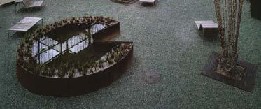
, buildings can rise straight from sidewalk to top of building.")
41 Openness, Air and Sunlight Existing Requirements (Section 132.1) for Separation of Towers Upper story setbacks (up to 35 ) are required from interior property lines and from center of streets. However, due to street width here (82.5 ), buildings can rise straight from sidewalk to top of building. As buildings get even taller, there is concern that less sky would be visible from the ground.
42 Openness, Air and Sunlight Goal: As buildings get taller than the current height limits (550 ), openness to the sky from the ground should be preserved. Draft Controls: For buildings taller than 550, the setback from the center line of a major street (82.5 wide, e.g. Mission St) shall be increased from 35 up to 70. The setback from interior property lines shall remain at 35 for buildings taller than 550. For buildings immediately adjacent to the Transit Center or to sites where the height is lower, the setback from interior property lines may be waived.

43 Tower bulk and form Goal: Provide flexibility and sufficient allowance for the building core needs of tall buildings (>550 ), while ensuring that the buildings maintain elegant and slender proportions and profile. Draft Control: Do not limit the floorplate or dimensions for the lower tower of buildings taller than 550, and require reductions of at least 25% in the average floorplate and average diagonal for the upper tower.
44 Open Space and Public Amenity
45 Existing Code requires Public Open Space on-site publicly-accessible open space for all non-residential uses. Downtown Park Fee ($2/square foot) Issues: Lack of coordination to create larger, public spaces sited where most desirable; favors dispersed, smaller, privately-managed space on every individual site. Difficult for large buildings on constrained sites to provide open space. Over-production of plazas diminishes district character and the urban fabric. Downtown Park Fee does not provide sufficient funds for major new open space. Indoor public spaces challenging to create feel and function as public.
46 Public Open Space Goals: Provide flexibility and alternatives to meeting open space requirements that achieve District open space vision and coordination, and that enhance and improve access to planned public space, particularly the Transit Center Park. Draft Controls: Allow and encourage buildings to satisfy open space requirements through: direct connections to Transit Center Park paying in-lieu fee for public space improvements in District, specifically 2 nd /Howard space and additional public vertical connections to Transit Center Park

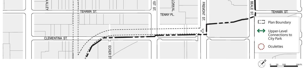
47 City Park Connections
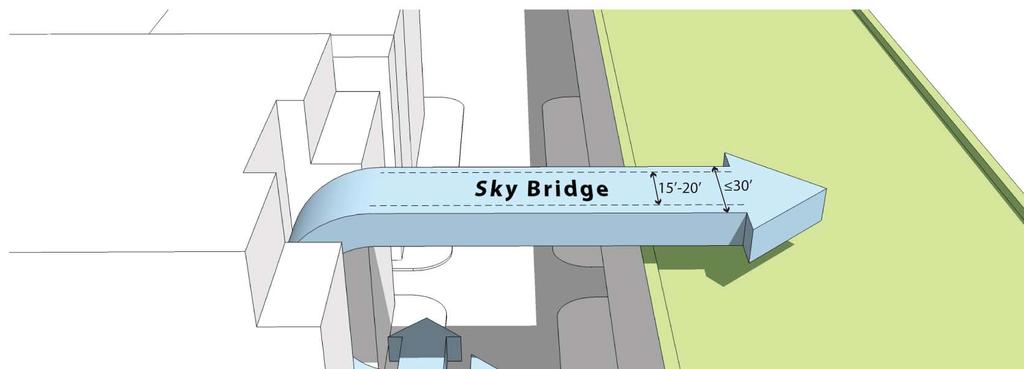

48 City Park Connections
49 City Park Connections Draft Controls: Buildings adjacent to Transit Center are encouraged to partially satisfy open space requirements by providing a direct pedestrian connection to the Transit Center park. The connection must be: at the park level. publicly accessible and connected to appropriate vertical circulation. minimize structure width if it crosses over Natoma or Minna Streets. meet other technical specifications be publicly accessible from sunrise to sunset, and at all times to residents if satisfying residential open space requirement. be clearly signed from a public way indicating public access to the Park.
50 2 nd /Howard Parcels Train Right-of of-way Parcels to be acquired for train construction Severely limited development potential due to train curvature below grade Loss of historic buildings (except removal and possible return of partial facades)


51 2 nd /Howard: Public Space, park connection New public space Significant signature vertical connection to City Park Contextual consistency with historic district Retail or other uses


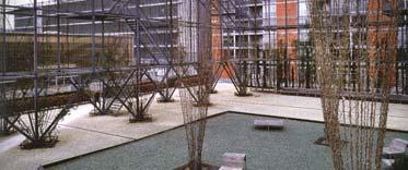


52 2 nd /Howard: Public Space, park connection Example of public space with similar qualities: MFO Park, Zurich
53 2 nd /Howard: Public Space, park connection

54 Public Open Space Draft Control: Open space for non-residential uses for new buildings in the District may be satisfied by payment of in-lieu fee into a Fund to construct and improve public space at NE corner of 2 nd /Howard and additional vertical connections to the Transit Center park.


55 Indoor Public Open Space Goal: Ensure that indoor open space is activated, feels public, can function independently of the building s primary uses, and does not feel like an extension of the building s private lobby. Draft Guidelines: Interior open space should have a distinct street presence separate from the primary building entrance or lobby to emphasize the public identity and use of the space. be abutted by one or more permanent enclosed retail spaces that open directly onto such interior open space as well as from a public sidewalk, plaza, or other outdoor public space. be accessible through permeable building openings without the need to open doors, such as through sliding or folding panels that can be propped open.


56 Public Amenity in Transit Tower Goal: The general public should have the ability to enjoy and access the incredible views from the tallest building in the city and region, and such unparalleled unique regional amenity should not be confined to only a few privileged building tenants. Draft Requirement: Any building taller than 800 feet (i.e. Transit Tower) must have a facility of public accommodation at a level no lower than 650 feet above grade that provides the general public the opportunity for views of the cityscape and Bay. Such facilities may include observation decks, restaurants, bars, lobbies, or any space accessible to members of the general public which does not require an appointment or membership, but which may charge a nominal fee for entrance.

57 Pedestrian Mid-block Connections Goal: Ensure that new development enhances the pedestrian network and reduces the scale of large blocks by maintaining and improving public access along existing alleys and creating new connections where none exist on long blocks and congested locations. Draft Requirements: A new public mid-block pedestrian pathway shall be required on Block 3721 connecting Howard and Natoma Streets between First and Second Streets. Elim Alley (varies 6 to 12 wide) may be built over, but should be improved through development for public pedestrian use and circulation.


58 Mid-block Connections Mid-block pathways must be at sidewalk grade and open to public passage. They need not be open to the sky, but must be at least 25 in height, 15 in width, open to at all times, and lined with lobbies or active uses. They are encouraged to be open to the air at both ends, such as an arcade or galleria, and not require opening of doors.


59 Shaw Alley Shaw Alley is a key link in the pedestrian network feeding the Transit Center. It connects to Ecker to the north and a planned mid-block crossing of Mission Street. The current proposal and requirement of the adjacent project at 535 Mission is to improve the alley and seek temporary lunchtime vehicular closure. Draft Proposal: Close Shaw Alley permanently to vehicles and design it as a pedestrian-only space for thru-connection to the Transit Center as well as open space.
60 Historic Resources

61 Historic Survey Historic Survey was completed in July posted on web site in July: o o Context Statement Building Survey Forms adopted by Landmarks Preservation Advisory Board on August 20th (except for consultant recommendations, which are being evaluated by staff and proposals will be included as part of Plan)

62 Existing Historic Districts

63 Existing Historic Districts


64 Areas of Examination for Potential District Expansion


65 Howard Street between 1 st and 2 nd Streets South side of Howard Street


66 Mission Street between New Montgomery and 3 rd Streets South side of Mission Street
67 Historic Resources Survey: Individually Significant Buildings 56 individually significant buildings including those listed or determined eligible.
68 Existing Article 11 Category Designations

69 Proposed District and Article 11 Category Designations
70 Potential Article 10 Landmarks


71 Potential Article 10 Landmarks Marine Fireman s Union Building (240 2 nd Street, Built 1957) Planters Hotel (606 Folsom, Built 1907) Phillips Building (234 1 st Street, Built 1929)
72 Historic Resource Actions of the Plan Expansion of New Montgomery-2 nd St Conservation District Article 11 Rating of individual buildings (Category 1-5) in expanded district Protection of individual resources not in Conservation District Article 11 Rating (Category 1-5) and/or Article 10 Landmark Designation Other considerations: Ability of building owners of rated buildings to sell Transferable Development Rights (TDR) Further design guidelines within Conservation District Potential adjustment of height limits
73 Sustainability
74 District Plan Sustainability Objectives Support (and were possible exceed) existing City environmental, sustainability and climate change objectives Pursue district-level sustainability programs and objectives that require higher-level coordination and district-scale planning Require and enable low impact, high performance development within the Transit Center development area
75 Areas of District Plan Focus Transportation District energy and renewables Storm water Urban Forest Green Building


76 Transportation SF Climate Action Plan Citywide Goal: Reduce CO2 emissions from transportation by 963,000 tons annually by getting: 9,325 solo drivers to walk to work, 9,325 to bicycle to work, 16,800 to carpool or vanpool, and 105,350 to switch to transit.
77 Goal: Transportation Build on strong existing parking controls and update controls to reflect broader transportation modes and increased densities. Existing Downtown (C-3) Controls: Auto Parking: No minimum requirements Maximum limits on residential and non-residential parking Required short-term pricing Bicycles: Residential Bicycle Parking minimums Showers and Lockers in Commercial Buildings Some Bicycle Parking for Commercial Buildings Car-Sharing Parking for Residential Buildings Transit Impact Development Fee (TIDF) Required Participation in Transportation Demand Management Association (TMA)
78 Transportation Issues: TDM/TMA requirements and procedures adopted in 1988 need to be updated and do not reflect full range of modes (e.g. bicycling, car sharing) and programs. Bicycle parking requirements for employees are very low: maximum of 12 spaces for buildings larger than 25,000 gsf. (12 spaces for up to 2,000 employees in 500,000 gsf office building). No requirement for car sharing parking spaces in non-residential buildings downtown, existing parking lots used by car sharing being eliminated. Current low maximum parking limits would still lead to large garages for very large buildings as proposed in the Plan Substantially increased densities adding significant demands on transit system

79 Transportation Draft Policies and Controls: Fund effort to update TDM/TMA requirements and include bicycling, car sharing, parking cash-out, etc. Amend Sec. 166 to require car-sharing spaces in nonresidential garages Amend Sec to increase number of required onsite secure bicycle parking spaces for commercial buildings to accommodate 5% of all on-site employees bicycling to work (i.e. 1 space for every 6,000 gsf of office space). Additional transit and traffic mitigations fees Off-street parking impact fee to discourage parking and mitigate impacts Consider requiring Conditional Use for garages larger than 100 spaces and setting absolute maximum cap on number of parking spaces in district

80 Transportation and Complete and adopt the proposed comprehensive Streetscape and Circulation Plan that facilitates increased pedestrian, transit, and bicycling volumes and movements.
81 Energy SF Climate Action Plan Citywide Goal: Reduce 400,000 tons of CO2 annually through energy efficiency and to displace 3,000 tons of CO2 annually through development of renewable energy and co-generation resources by 2009.
 Promote / require use of renewable energy technology within the district (ground source, PV, wind) Highly energy efficient")
82 Energy Transit Center District Plan Strategies: Consideration of creation of highly efficient district energy network (providing heating, cooling and power) Promote / require use of renewable energy technology within the district (ground source, PV, wind) Highly energy efficient buildings
83 Energy Goal: Take advantage of balanced dense mixed-use development in the Transit Center District and Transbay Redevelopment Area to create efficient shared district energy and heating system that captures and uses waste heat from generation and buildings. Draft Policies: Pursue a Combined Heat and Power (CHP) system for the plan area and the Transbay Redevelopment area (Zone 1). Require new buildings to be designed to plug into such a system. Find suitable sites for generation facilities in the district.

84 Energy: District CHP

85 Energy: District CHP
86 Energy: District CHP Requirements for a district energy system High load density (floor area, no. of stories and total number of buildings) Diversity of building types with different demand profiles 5000 hours /yr minimum heating or cooling
87 Energy: District CHP Very dense and balanced mixed land uses in Plan Area + Transbay Redevelopment Area: Over 6,000,000 gsf office space and retail Over 3,500 housing units

88 Energy: District CHP Draft Requirement: All major development must demonstrate that proposed heating and cooling systems have been designed in accordance with the following order of diminishing preference: connection to existing CHP distribution networks site-wide CHP powered by renewable energy gas-fired CHP or hydrogen fuel cells, both accompanied by renewables communal heating and cooling powered by renewable energy gas fired communal heating and cooling.
89 Energy: District CHP Further Analysis of Issues/Opportunities Location of Plants: Dispersed in multiple sites as network Phased according to development Basements of major new buildings Public sites with space or without current development program Distribution: Major street and utility work already included in Transit Center, streetscape, development projects


90 Water Citywide Storm Water guidelines: Capture and treat 80% or more of annual storm water runoff volumes


91 Water Transit Center District Goals: Reduce volume and speed of stormwater runoff Reduce potable water use Transit Center District Measures: Low-Impact Design ( LID ) for streetscape and open space improvements Bio-retention planters Permeable paving Street trees Building rainwater harvesting Green roofs and walls


92 Water LID techniques also help mitigation climate change impacts Cisterns Appropriate Roof + Non-roof Surfaces Improved Air Quality Storm water Reduction CLIMATE CHANGE ADAPTATION Minimize Temperature Rise Green Roofs Street Trees Improve Public Realm Enhance Ecological Diversity Living Walls Planters


93 Urban Forest SF Climate Action Plan Citywide Goal: Plant and maintain 25,000 new trees in San Francisco by 2012, offsetting 2,500,000 pounds of CO2 annually.


94 Urban Forest Transit Center District Measures: Major tree planting on streets in tandem with sidewalk and public space enhancements Living Streets Beale, Main, Spear double rows of trees Street trees on all streets

95 Green Building SF Climate Action Plan Goal: Ensure that all new commercial and residential buildings in San Francisco eventually meet LEED Gold Standard.

96 Green Building San Francisco Green Building Ordinance Adopted 2008
97 Green Building Project in the Plan area automatically achieve minimum 5 points (7%) due to location and existing city planning requirements Site selection Development density Public transit accessibility Bicycle storage requirements Parking standards
98 Green Building Goal: Ensure that major buildings are low-impact and high performance (with regards to energy, water, materials, construction) not accounting for the given inherent factors of location, density and existing city parking controls. Draft Policy: Require all major buildings in the Plan Area to achieve the minimum LEED levels established in the SF Green Building Ordinance without accounting for the given points based on location, density, and City parking standards.
99 Future Workshops Repeat of this presentation: Thursday October 9 th Transbay Redevelopment Area Citizen s s Advisory Committee Meeting 5:30pm Yerba Buena Center for the Arts
100 Future Workshops Workshop #4 Fall (November) Topics: Financial Plan/Public Benefits Refinements of Plan Ideas Draft Plan for Public Review document to be published by end of year
101 Contact Please Sign In Joshua Switzky transitcenter.sfplanning.org
102 Thank You Comments?
José Campos Manager of Planning and Design Review SPUR San José Symposium October 12, 2018
 1 Transbay: Freeways to New Ways José Campos Manager of Planning and Design Review SPUR San José Symposium October 12, 2018 2 Transbay freeway land pre-1989 3 1989 Loma Prieta Earthquake 4 TRANSBAY c.
EXISTING COMPREHENSIVE PLAN
 EXISTING COMPREHENSIVE PLAN Town Center Land Use Element: V. LAND USE POLICIES Town Center Mercer Island's business district vision as described in "Your Mercer Island Citizen-Designed Downtown" was an
Official Plan Review: Draft Built Form Policies
 PG.30.1 REPORT FOR ACTION Official Plan Review: Draft Built Form Policies Date: May 15, 2018 To: Planning and Growth Management Committee From: Chief Planner and Executive Director, City Planning Division
Town Center (part of the Comprehensive Plan)
") Town Center (part of the Comprehensive Plan) Mercer Island Town Center Looking North (2014) In 1994, a year-long process culminated in a set of design guidelines and code requirements for the Town Center
Town Center (part of the Comprehensive Plan) Mercer Island Town Center Looking North (2014) In 1994, a year-long process culminated in a set of design guidelines and code requirements for the Town Center
WEST LOOP DESIGN GUIDELINES CHECKLIST
 WEST LOOP DESIGN GUIDELINES CHECKLIST Section 1.0 General Strategies 1.1 DESIGN EXCELLENCE: ENCOURAGE HIGH QUALITY AND INNOVATIVE DESIGN OF NEW BUILDINGS WITHIN THE WEST LOOP WITHOUT BEING PRESCRIPTIVE
5M PROJECT/ PLANNING COMMISSION INFORMATIONAL JULY 23, 2015
 5M PROJECT/ PLANNING COMMISSION INFORMATIONAL JULY 23, 2015 TIMELINE 2008-2009 2009-2011 2011-2013 2013-2014 INITIAL FACTORS > Identification of four-acre Chronicle soft site > Prioritizing preservation
Uptown Rideau Street Secondary Plan [Amendment #166, January 12, 2016]
![Uptown Rideau Street Secondary Plan [Amendment #166, January 12, 2016]](/thumbs/76/73760497.jpg "Uptown Rideau Street Secondary Plan [Amendment #166, January 12, 2016]") [Amendment #166, January 12, 2016] The policies of this Secondary Plan are in effect, save and except for the property at 560 Rideau Street, for which there remains a site specific appeal to this Secondary
[Amendment #166, January 12, 2016] The policies of this Secondary Plan are in effect, save and except for the property at 560 Rideau Street, for which there remains a site specific appeal to this Secondary
Clairtrell Area Context Plan
 Clairtrell Area Context Plan March 2005 Urban Development Services City Planning Contents 1. Introduction... 4 2. Development Structure... 6 2.1 Streets... 7 2.1.1 Sheppard Avenue and Bayview Avenue...
(DC1) Direct Development Control Provision DC1 Area 4
 Direct Development Control Provision DC1 Area 4") . General Purpose (DC) Direct Development Control Provision DC Area 4 The purpose of this Provision is to provide for an area of commercial office employment and residential development in support of the
. General Purpose (DC) Direct Development Control Provision DC Area 4 The purpose of this Provision is to provide for an area of commercial office employment and residential development in support of the
Policies and Code Intent Sections Related to Town Center
 Policies and Code Intent Sections Related to Town Center The Town Center Vision is scattered throughout the Comprehensive Plan, development code and the 1994 Town Center Plan. What follows are sections
3.0 URBAN DESIGN. December 6, OVERVIEW
 Urban Design 3.0 URBAN DESIGN December 6, 2007 3.1 OVERVIEW The highly urban character of Easton Place is defined by the overall design of the community. The following sections provide an overview of the
Buildings may be set back to create small plazas provided that these setbacks do not substantially disrupt the street wall s continuity.
 6-22 Community Design Street Walls and Street-front Setbacks The siting of buildings will play a critical role in establishing the character and sense of place for the District. Siting buildings at the
Tonight s Agenda. Summary Presentation Open House. Group Discussion Next Steps: online community wide survey
 Community Open House February 22, 2018 Tonight s Agenda Summary Presentation Open House Station 1: Project Overview and Community Input Station 2: Draft Vision and Guiding Principles Station 3: Western,
Developer s Program. The Station at East 54
 Developer s Program The Station at East 54 Existing Conditions The Station at East 54 is proposed for a 1.12 acre site at the northeast corner of Hamilton Road and Prestwick Road, tucked between the East
PLAN ELEMENTS WORKSHOP. April 5, 2016
 PLAN ELEMENTS WORKSHOP April 5, 2016 needs more housing. But there is no one-size fits-all solution. Every neighborhood has its own character. In some places, density is not only appropriate it is badly
Future Five. Design/ Development Guidelines. January 2008 Amended June 08 per City Council motion
 Future Five Design/ Development Guidelines January 2008 Amended June 08 per City Council motion 5-Points Design Guidelines Table of Contents I. Introduction 3 II. Area boundaries 4 III. Review Process
Highland Village Green Design Guidelines
 Highland Village Green Design Guidelines Publishing Information Title Highland Village Green Design Guidelins Author The City of Calgary Status DRAFT - Proposed document subject to changes Additional Copies
THE GREEN VISION WORKSHOP Friday, November 6, 2009
 THE GREEN VISION WORKSHOP Friday, November 6, 2009 SUSTAINABLE LONG RANGE PLANNING IN SANTA MONICA Eileen Fogarty Director, Planning and Community Development GREEN BUILDINGS Santa Monica has the most
Citizen Advisory Group Meeting 5: Land Use April 14, 2011
 Citizen Advisory Group Meeting 5: Land Use April 14, 2011 Meeting Agenda 1. Background Review 2. Transportation Follow-up 3. PED Overlay Approach 4. Land Use Mapping 5. Group Exercise 6. Wrap-up and Next
FRUITVALE TRANSIT VILLAGE (Phase 2) Residential Project
 Residential Project") FRUITVALE TRANSIT VILLAGE (Phase 2) Residential Project DEVELOPER: SIGNATURE PROPERTIES ARCHITECT: HKIT ARCHITECTS April 23, 2010 TABLE OF CONTENTS 3 Vision 4 Description of Site 5 Guiding Concepts 6
FRUITVALE TRANSIT VILLAGE (Phase 2) Residential Project DEVELOPER: SIGNATURE PROPERTIES ARCHITECT: HKIT ARCHITECTS April 23, 2010 TABLE OF CONTENTS 3 Vision 4 Description of Site 5 Guiding Concepts 6
Urban Design Manual PLANNING AROUND RAPID TRANSIT STATIONS (PARTS) Introduction. Station Study Areas
 Introduction. Station Study Areas") 111111 PLANNING AROUND RAPID TRANSIT STATIONS (PARTS) Introduction The ION rapid transit system will link Waterloo, Kitchener and Cambridge through a central transit corridor (CTC). There are a number
111111 PLANNING AROUND RAPID TRANSIT STATIONS (PARTS) Introduction The ION rapid transit system will link Waterloo, Kitchener and Cambridge through a central transit corridor (CTC). There are a number
Executive Summary General Plan Amendment Initiation
 Executive Summary General Plan Amendment Initiation HEARING DATE: AUGUST 6, 2015 Date: July 30, 2015 Case No.: 2011.0409PCA Project Address: 925 Mission Street and various parcels (aka 5M ) Existing Zoning:
The broad range of permitted and special uses allowed in the district remain, but some descriptions have been clarified.
 Memorandum To: Emily Fultz, AICP City Planner, City of Edwardsville From: Michael Blue, FAICP Principal, Teska Associates Date: January 24, 2019 RE: B-1 Zoning District Update A draft, updated B-1 Central
appendix and street interface guidelines
 appendix five: building and street interface guidelines appendix 5 building and street interface guidelines BOULEVARDS Boulevards are generally characterized by higher levels of traffic movement at higher
Complete Neighbourhood Guidelines Review Tool
 Complete Neighbourhood Guidelines Review Tool Prepared By: City of Regina Planning Department October 2014 Page 1 of 14 Community Development Review Checklist for Secondary Plans and Concept Plans The
The West Vaughan Employment Area Secondary Plan Policies
 Part 2: The West Vaughan Employment Area Secondary Plan Policies 2.1 General Policies It is the policy of Council: 2.1.1. That the West Vaughan Employment Area (the WVEA), identified on Schedule 1, will
Appendix E: Illustrative Green Infrastructure Examples
 Appendix E: Illustrative Green Infrastructure Examples Integrating LID into San Francisco s Urban Landscape Figure E. High-density Residential Figure E. Low-density Residential Figure E. Mixed Use 7 Figure
CENTERS AND CORRIDORS
 INITIAL DESIGN STANDARDS AND GUIDELINES for CENTERS AND CORRIDORS City of Spokane Planning Services Third Floor, City Hall 808 W. Spokane Falls Blvd. Spokane, WA 99201-3329 (509) 625-6300 www.spokaneplanning.org
Seneca Meadows. Block 4 Locate office, technology, and medical development adjacent to I Screen views of garage structures from I-270.
 Seneca Meadows Seneca Meadows has an industrial park in its southern end and a mixed-use employment area planned for the north end. The district benefits from extensive I-270 visibility, stream valley
Bayshore Boulevard Home Improvement District Design Guidelines
 Bayshore Boulevard Home Improvement District Design Guidelines guidelines for New construction projects and major alterations IN the bayshore boulevard home improvement special use DISTRICT SAN FRANCISCO
Workshop 3. City of Burlington Waterfront Hotel Planning Study. September 14, The Planning Partnership
 Workshop 3 City of Burlington Waterfront Hotel Planning Study September 14, 2017 The Planning Partnership The Waterfront Hotel Planning Study 01 The Brant & Lakeshore Planning Study will establish a Strategic
ELMVALE ACRES SHOPPING CENTRE MASTER PLAN
 ELMVALE ACRES SHOPPING CENTRE MASTER PLAN Contents 1.0 INTRODUCTION... 2 2.0 LOCATION... 2 3.0 EXISTING CONTEXT... 2 4.0 VISION & GUIDING PRINCIPLES... 2 5.0 LAND USE AND BUILT FORM... 4 5.1 St. Laurent
King-Spadina Secondary Plan Community Consultation Meeting. Michelle Knieriem, City Planner October 11, 2017
 King-Spadina Secondary Plan Community Consultation Meeting Michelle Knieriem, City Planner October 11, 2017 Agenda 6:30 Welcome 6:35 Presentation 7:15 Question and Answer Session 8:15 Closing Remarks HOW
North Downtown Specific Plan MEMORANDUM
 North Downtown Specific Plan MEMORANDUM MEETING DATE: November 13, 2017 TO: Members of the North Downtown Specific Plan Advisory Committee FROM: Jeanine Cavalli, Senior Planner SUBJECT: Materials for the
VISION AND GUIDING DESIGN PRINCIPLES
 pleasure point commercial corridor VISION AND GUIDING DESIGN PRINCIPLES Public Draft November 26, 2018 County of Santa Cruz with assistance from MIG CONTENTS PART I: INTRODUCTION AND VISION... 3 Community
WINDSOR GLEN DESIGN GUIDELINES
 WINDSOR GLEN DESIGN GUIDELINES Adopted by Council, 2006 WINDSOR GLEN REDEVELOPMENT DESIGN GUIDELINES August 2006 1.0 Master Plan Organization For this area of the Coquitlam Town Centre, a mix of high,
Regency Developments. Urban Design Brief. Holyrood DC2 Rezoning
 Regency Developments Urban Design Brief Holyrood DC2 Rezoning Stantec Consulting Ltd. 7-31-2017 1. Overview Regency Developments intends to rezone the lands located at 8510 and 8511 93 Avenue, within the
Welcome to the Oakridge Centre Open House
 Welcome to the Oakridge Centre Open House Why is the City hosting this event? This open house is to inform you of a rezoning application submitted to the City of Vancouver to amend the existing CD-1 (Comprehensive
McDonald s Restaurant - Purcellville Town of Purcellville Special Use Permit Statement of Justification July 24, 2014
 Introduction / Written Statement McDonald s Restaurant - Purcellville McDonald s Corporation is proposing to redevelop the existing McDonald s eating establishment with a drive-through located at 121 N
The transportation system in a community is an
 7 TRANSPORTATION The transportation system in a community is an important factor contributing to the quality of life of the residents. Without a sound transportation system to bring both goods and patrons
DRAFT Northeast Quadrant of Kipling Avenue and Highway 7 DRAFT AUGUST 29, Goals Land Use. The goals of this Plan are to:
 AUGUST 29, 2017 12.15 Northeast Quadrant of Kipling Avenue and Highway 7 12.15.1 Goals 12.15.2 Land Use The goals of this Plan are to: 12.15.2.1 General Provisions: a) Ensure the development of a compact
TRANSIT ORIENTED DEVELOPMENT PINELLAS COUNTY MPO LIVABLE COMMUNITIES INITIATIVE PINELLAS COUNTY COMPREHENSIVE PLAN AMENDMENTS
 PINELLAS COUNTY MPO LIVABLE COMMUNITIES INITIATIVE MODEL LAND DEVELOPMENT CODE TRANSIT ORIENTED DEVELOPMENT PINELLAS COUNTY COMPREHENSIVE PLAN AMENDMENTS MPO Livable Communities Initiative Goal: Improve
CHAPTER 3. Design Standards for Business, Commercial, Industrial, Recreational and Institutional Uses
 CHAPTER 3 Design Standards for Business, Commercial, Section Number Title Ordinance Number Date of Ordinance 16-3-1 Applicability 2006-11 2008-04 07-01-08 16-3-2 Uniform Standards for Architectural Design
City Council Presentation November 6, 2017
 City Council Presentation November 6, 2017 Paul Jensen Recap Downtown Vision Key issues 3-D simulation exercise (CivicKnit - Breeze Kinsey) Planning Commissioner Larry Paul Elements of good design Next
University of the District of Columbia Van Ness Campus Master Plan Community Open House 3. December 8, 2010
 University of the District of Columbia Van Ness Campus Master Plan Open House 3 December 8, 2010 Introductions Sequence of Work: Campus Master Plan BEGIN: INTRODUCE AND START WORK Project Initiation Team
Chapter PEDESTRIAN COMMERCIAL (PC) ZONING DISTRICT
 ZONING DISTRICT") Chapter 11-17 PEDESTRIAN COMMERCIAL (PC) ZONING DISTRICT Sections: 11-17-01 GENERAL PURPOSE 11-17-02 PERMITTED BUILDING TYPES 11-17-03 USES PERMITTED WITH DESIGN REVIEW 11-17-04 USES PERMITTED BY CONDITIONAL
Chapter 11-17 PEDESTRIAN COMMERCIAL (PC) ZONING DISTRICT Sections: 11-17-01 GENERAL PURPOSE 11-17-02 PERMITTED BUILDING TYPES 11-17-03 USES PERMITTED WITH DESIGN REVIEW 11-17-04 USES PERMITTED BY CONDITIONAL
A. Background Summary of Existing Challenges and Potential Possibilities. 1. Summary of Existing Assets and Potential Opportunities
 A. Background 1 A Main Street Master Plan Study was performed and completed in October of 2007. The study was initiated to review current land uses and development patterns along Main Street, from Parrish
Toronto Complete Streets Guidelines
 Toronto Complete Streets Guidelines 108 110 7.1 Green Infrastructure Design Principles 112 7.2 Context-Sensitive Green Streets 114 7.3 Key Green Street Elements Green infrastructure refers to natural and
Site Planning. 1.0 Site Context. 2.0 Pedestrian Circulation Systems. Pag e 2-23
 The following photographs from throughout the country illustrate key urban design principles. Photographs are provided to illustrate the overall urban design concepts described in Chapter 1 of the Downtown
Public Open House. Overview of the Downtown Plan Official Plan Amendment April 23, 2018
 Public Open House Overview of the Downtown Plan Official Plan Amendment April 23, 2018 1 A 25-Year Plan for Downtown To ensure growth contributes positively to Toronto s Downtown as a great place to live,
HISTORIC TOWN CENTER MASTER PLAN CITY COUNCIL PRESENTATION APRIL 3, 2012
 HISTORIC TOWN CENTER MASTER PLAN CITY COUNCIL PRESENTATION APRIL 3, 2012 REQUESTED CITY COUNCIL ACTIONS Certification of the Final Program Environmental Impact Report (PEIR); and, Approval of General Plan
Courthouse Square Planning & Urban Design Study. Courthouse Square Working Group #13 October 15, 2014
 Courthouse Square Planning & Urban Design Study Courthouse Square Working Group #13 October 15, 2014 1 Courthouse Square Process Working Group Community Courthouse Square Advisory Groups & Civic Associations
CITY OF PUYALLUP. Background. Development Services
 CITY OF PUYALLUP Development Services 333 South Meridian Puyallup WA 98371 To: City Council From: Katie Baker, AICP, Planning Division Re: South Hill Neighborhood Plan Adoption Date: (Meeting date: February
Silverdale Regional Center
 Silverdale Regional Center Vision for Silverdale Regional Center The Silverdale Regional Center Plan (Plan) will guide the evolution of the Silverdale Regional Center from a collection of strip malls and
ARTICLE 6: Special and Planned Development Districts
 ARTICLE 6: Special and Planned Development Districts 6-10 Traditional Neighborhood Development (TND) District 6-10.10 Purpose and Intent The Traditional Neighborhood Development (TND) District provides
Bank Street Secondary Plan
 1.1 Introduction The is a guide to the long term design and development of the portion of Bank Street between Riverside Drive and Ledbury Park, and provides direction on land use, built form, design, parking,
DRAFT. October Wheaton. Design Guidelines
 October 2011 DRAFT Wheaton Design Guidelines 2 Draft - Design Guidelines - Wheaton Sector Plan Contents 04 Section 1: Introduction 06 Section 2: Context 08 Section 3: Design Guidelines 09 Goal 1: Create
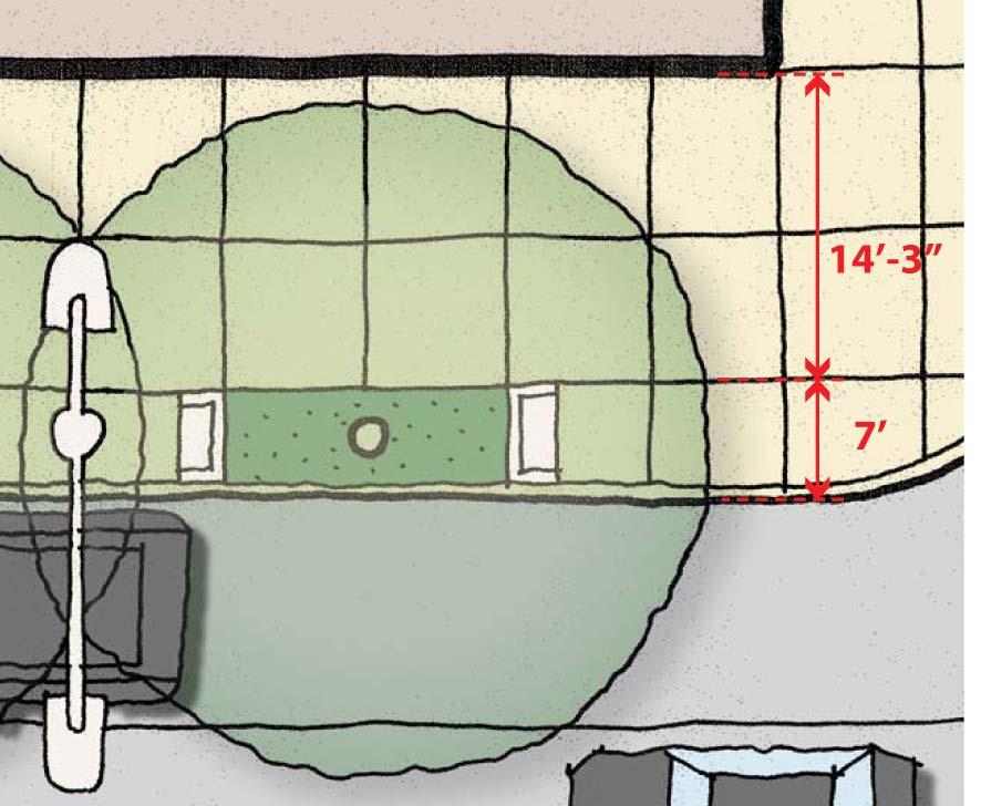
Subject: 30 Otis Street, Evaluation of Shadow on Proposed 11th and Natoma Park
 Date: September 5, 2018 To: Recreation and Park Commission Capital Committee Through: Philip A. Ginsburg, General Manager Toks Ajike, Director, Capital & Planning Division From: Brian Stokle, Planner,
The Five Components of the McLoughlin Area Plan
 The Five Components of the McLoughlin Area Plan This documents contains the complete language of the five components of the McLoughlin Area Plan: The Vision Statement The Values The Guiding Principles
I. Introduction. Prior Approvals
 Statement of Justification First National Bank 19790 Crystal Rock Drive, Germantown, Maryland Application for Site Plan and Limited Preliminary Plan Amendment I. Introduction DPH Architecture, for First
SUBJECT: PREDEVELOPMENT PLAN REVIEW OF PROJECT LOCATED AT E. COLORADO BOULEVARD (PASEO COLORADO)
") TO: FROM: Honorable Mayor and City Council Planning & Community Development Department SUBJECT: PREDEVELOPMENT PLAN REVIEW OF PROJECT LOCATED AT 260-400 E. COLORADO BOULEVARD (PASEO COLORADO) RECOMMENDATION:
TO: FROM: Honorable Mayor and City Council Planning & Community Development Department SUBJECT: PREDEVELOPMENT PLAN REVIEW OF PROJECT LOCATED AT 260-400 E. COLORADO BOULEVARD (PASEO COLORADO) RECOMMENDATION:
Incentive Zoning Regulations Florida Municipal City of Orlando
 Topic: Resource Type: State: Jurisdiction Type: Municipality: Year (adopted, written, etc.): 2002 Community Type applicable to: Title: Incentive Zoning Regulations Florida Municipal City of Orlando Document
REQUEST Current Zoning: O-15(CD) (office) Proposed Zoning: TOD-M(CD) (transit oriented development mixed-use, conditional)
 (office) Proposed Zoning: TOD-M(CD) (transit oriented development mixed-use, conditional)") Rezoning Petition 2016-117 Zoning Committee Recommendation January 4, 2017 REQUEST Current Zoning: O-15(CD) (office) Proposed Zoning: TOD-M(CD) (transit oriented development mixed-use, conditional) LOCATION
Rezoning Petition 2016-117 Zoning Committee Recommendation January 4, 2017 REQUEST Current Zoning: O-15(CD) (office) Proposed Zoning: TOD-M(CD) (transit oriented development mixed-use, conditional) LOCATION
A. WHAT IS A GENERAL PLAN?
 I. Introduction A. WHAT IS A GENERAL PLAN? A general plan is the planning guideline for the future of a city. It contains goals and policies which regulate urban development, the protection of the natural
13 THORNHILL YONGE STREET STUDY IMPLEMENTATION CITY OF VAUGHAN OPA 669 AND TOWN OF MARKHAM OPA 154
 13 THORNHILL YONGE STREET STUDY IMPLEMENTATION CITY OF VAUGHAN OPA 669 AND TOWN OF MARKHAM OPA 154 The Planning and Economic Development Committee recommends the adoption of the recommendations contained
DRAFT DESIGN GUIDELINES
 IHZ Booklet #7 May 6, 2010 DRAFT DESIGN GUIDELINES CANTERBURY 7 Overview During the recent planning process for the Plan of Conservation and Development community character was identified as an important
Residential Commons at Barry s Corner. Boston civic design commission February 5, 2013
 Residential Commons at Barry s Corner Boston civic design commission February 5, 2013 TABLE OF CONTENTS project summary 3 PROJECT site 4 PLANNING APPROACh 6 Parcel Diagams 6 Design Principles 8 Street
Welcome. Walk Around. Talk to Us. Write Down Your Comments
 Welcome This is an information meeting introducing the applications for proposed redevelopment of the Yorkdale Shopping Centre site at 3401 Dufferin Street and 1 Yorkdale Road over the next 20+ years,
Courthouse Square Planning & Urban Design Study Working Group Meeting #11 September 2, 2014
 Courthouse Square Planning & Urban Design Study Working Group Meeting #11 September 2, 2014 1 Study Area Courthouse Square DRAFT Design Concepts A B C 3 Public Feedback July 23 Workshop & Online Survey
The Baileys Planning District portion of the Comprehensive Plan contains site design recommendations for both the Baileys Crossroads Community
 The Baileys Planning District portion of the Comprehensive Plan contains site design recommendations for both the Baileys Crossroads Community Business Center and the Seven Corners Community Business Center.
Joint Study Session of the Sutter County. March 2, 2009
 Joint Study Session of the Sutter County Board of Supervisors and Planning Commission March 2, 2009 CURRENT APPLICATION General Plan Amendment Specific Plan Specific Plan Appendices Utility Plans Transit/AQ
FORMER CANADIAN FORCES BASE (CFB) ROCKCLIFFE SECONDARY PLAN. Official Plan Amendment XX to the Official Plan for the City of Ottawa
 ROCKCLIFFE SECONDARY PLAN. Official Plan Amendment XX to the Official Plan for the City of Ottawa") FORMER CANADIAN FORCES BASE (CFB) ROCKCLIFFE SECONDARY PLAN Official Plan Amendment XX to the Official Plan for the City of Ottawa 1 INDEX THE STATEMENT OF COMPONENTS PART A THE PREAMBLE PAGE Purpose...
FORMER CANADIAN FORCES BASE (CFB) ROCKCLIFFE SECONDARY PLAN Official Plan Amendment XX to the Official Plan for the City of Ottawa 1 INDEX THE STATEMENT OF COMPONENTS PART A THE PREAMBLE PAGE Purpose...
MISSION STREETSCAPE PLAN. Neighborhood Commercial Streets handle continuous activity. Neighborhood Commercial STREET ROW: Main Design Treatments
 Neighborhood Commercial STREET ROW: 64-80 Main Design Treatments CORNER reduce crossing distance for pedestrians, create entrances to a residential area and slow cars down. help widen sidewalk allocating
QUEEN-RIVER SECONDARY PLAN
 34 QUEEN-RIVER SECONDARY PLAN 34. QUEEN RIVER SECONDARY PLAN 1. INTRODUCTION The Queen-River area is approximately 6.4 hectares and is located at the eastern edge of the Downtown as shown on Map 34-1.
TALL BUILDING GUIDELINES
 TALL BUILDING GUIDELINES Urban Design Guidance for the Site Planning and Design of Tall Buildings in Milton May, 2018 A Place of Possibility Contents 1.0 INTRODUCTION 1 1.1 What is a Tall Building? 2
DOWNTOWN GEORGETOWN PLANNING STUDY
 DOWNTOWN GEORGETOWN PLANNING STUDY Community Workshop #3 Thursday, May 4, 08 The Planning Partnership OVERVIEW OF STUDY, PROCESS & MILESTONES We are here PURPOSE OF THE STUDY To develop a clear vision
The underlying goals of the study and resultant zoning recommendations are to:
 Stuart Street Planning Study Advisory Group Proposed Zoning Recommendations to replace Back Bay Downtown IPOD (1987) DRAFT OCT 20, 2009 Preface Background The Stuart Street Planning Study area, bound by
Future Proposed Development
 Future Proposed Development on and around Link light rail s Capitol Hill Station Meeting September 24, 2012 Tonight s Agenda 6:00 pm Open House 6:30 pm Introductions Richard Conlin, City of Seattle Councilmember/Sound
EXHIBIT A. Tax Increment Reinvestment Zone No. 1 (Town Center) First Amended Project Plan 1
 First Amended Project Plan 1") EXHIBIT A Tax Increment Reinvestment Zone No. 1 (Town Center) First Amended Project Plan 1 1 As amended by Resolution No. 2008-02-001(TR1R) of the Tax Increment Reinvestment Zone No.1, and approved to
EXHIBIT A Tax Increment Reinvestment Zone No. 1 (Town Center) First Amended Project Plan 1 1 As amended by Resolution No. 2008-02-001(TR1R) of the Tax Increment Reinvestment Zone No.1, and approved to
Draft Memorandum #1: Goals and Vision for Revitalization
 Keizer Revitalization Plan Draft Memorandum #1: Goals and Vision for Revitalization Submitted to: City of Keizer April 12, 2018 (revised) Prepared By: Angelo Planning Group and Otak, Inc. Project No. 17482.A
Good Design Guidelines for Downtown. Preliminary Findings and Recommendations
 Good Design Guidelines for Downtown Preliminary Findings and Recommendations City Council Meeting - February 5, 2017 Advisory Committee Team: Larry Paul: Planning Commission /Architect Bruce Bagnoli: Business
VICTORIA DOWNTOWN DEVELOPMENT PLANNING
 VICTORIA DOWNTOWN DEVELOPMENT PLANNING A Vision & Guide for the Future Downtown Victoria thrives as a center for the community, offering a great mix of entertainment, culture, business, and recreational
Mark-up of the effect of the proposed Bronte Village Growth Area OPA No.18 on the text of section 24, Bronte Village, of the Livable Oakville Plan
 Mark-up of the effect of the proposed Bronte Village Growth Area OPA No.18 on the text of section 24, Bronte Village, of the Livable Oakville Plan Notes: This document is provided for information purposes
Lehigh Acres Land Development Regulations Community Planning Project
 Lehigh Acres Land Development Regulations Planning Effort Summary In July, 2010 Commissioner Frank Mann invited the Lehigh Acres community to start discussing how to achieve their recently adopted community
3.1 community vision. 3.3 required plan elements
 Chapter 3 Community Form 3.1 community vision 3.2 Parks & landscaping concepts 3.3 required plan elements D R A F T 20 Community Form Chapter 3 3.0 Community form 3.1 community vision The Specific Plan
SAN RAFAEL GENERAL PLAN 2040 INTRODUCTION AND OVERVIEW
 SAN RAFAEL GENERAL PLAN 2040 INTRODUCTION AND OVERVIEW Steering Committee Presentation February 14, 2018 Purpose of General Plan Guide land use and development decisions Coordinate transportation, infrastructure,
ANC 2A Presentation. November 9, 2006
 ANC 2A Presentation November 9, 2006 Introduction & Overview Applicants Boston Properties and KSI Services (project developers) The George Washington University (land owner) 2.66 acre site (former GW hospital
Stuart Street Planning Study Development Review Guidelines to supplement Back Bay Downtown IPOD (1987) October 15, Preface
 October 15, Preface") Stuart Street Planning Study Development Review Guidelines to supplement Back Bay Downtown IPOD (1987) October 15, 2015 Preface Background The Stuart Street Planning Study area, bound by St. James Avenue
Stuart Street Planning Study Development Review Guidelines to supplement Back Bay Downtown IPOD (1987) October 15, 2015 Preface Background The Stuart Street Planning Study area, bound by St. James Avenue
Planning Board Briefing
 Planning Board Briefing Why Now? The Sector Plan Implementation Chapter States: Before Stage 1 begins, the following must occur: Approval of the Sectional Map Amendment. Approval of the Greater Lyttonsville
PUBLIC RIGHT-OF-WAY IN THIS CHAPTER PUBLIC REALM
 PUBLIC RIGHT-OF-WAY This section provides design guidelines for improvements in the public right-of-way. The public right-of-way refers to streets, sidewalks, non-vehicular thoroughfares, parks and greenways
Metro. Activity Center Design Guidelines. Recommendations For Developing Focused, Mixed-Use Commercial/Residential Centers
 Metro Activity Center Design Guidelines Recommendations For Developing Focused, Mixed-Use Commercial/Residential Centers Metro Activity Centers What is a MAC? Legacy, the adopted guide for the future growth
Historic Preservation Preserve, restore or adaptively re-use historic structures and landscapes.
 Checklist for New Construction Developers of building projects in the Loring Park Neighborhood are encouraged to pursue the standards that are identified below. For large projects requiring special allowances,
ARLINGTON COUNTY, VIRGINIA
 ARLINGTON COUNTY, VIRGINIA County Board Agenda Item Meeting October 15, 2005 DATE: September 28, 2005 SUBJECT: Request to Advertise the adoption of the 2005 Clarendon Sector Plan C. M. RECOMMENDATION:
City of Hermosa Beach Administrative Policy #
 City of Hermosa Beach Administrative Policy # SUBJECT: Living Streets Policy Date: Approved by: City Council Authority: Public Works Department & Community Development Department Mayor, PURPOSE The City
C. Westerly Creek Village & The Montview Corridor
 C. Westerly Creek Village & The VISION Community Vision When the goals of the city are achieved Westerly Creek Village, a distinctive community defined by Montview Boulevard and Westerly Creek, is a strong
S A C R A M E N T O C O U N T Y JACKSON HIGHWAY & GRANT LINE EAST VISIONING STUDY
 JACKSON HIGHWAY & GRANT LINE EAST S A C R A M E N T O C O U N T Y P L A N N I N G D E P A R T M E N T SUMMARY AND WORKBOOK November 19, 2008 History of the Visioning Study Sacramento County has two growth
Design Guidelines. Roosevelt. Mike Podowski DPD Design Guidelines Ordinance ATT 13 August 13, 2012 Version #1
 Roosevelt Design Guidelines The Roosevelt Neighborhood Design Guidelines apply within the Neighborhood Boundary. Map 1 2 Map 2 3 Map 3 4 CS1 Natural Systems and Site Features Citywide Guideline: Use natural
GUIDING PRINCIPLES IN THIS CHAPTER
 GUIDING PRINCIPLES The guiding principles and design concepts in this chapter work together with the Chapel Hill 2020 Comprehensive Plan to support new public places that can be enjoyed by all while also
Gold Line Bus Rapid Transit Transit Oriented Development (BRTOD) Helmo Station Area Plan
 Helmo Station Area Plan") Appendix F Gold Line Bus Rapid Transit Transit Oriented Development (BRTOD) Helmo Station Area Plan Introduction and Purpose of the Plan The Gold Line Bus Rapid Transit facility is an eleven-mile dedicated
Appendix F Gold Line Bus Rapid Transit Transit Oriented Development (BRTOD) Helmo Station Area Plan Introduction and Purpose of the Plan The Gold Line Bus Rapid Transit facility is an eleven-mile dedicated
~P'~'~; SAN FRANCISCO
 ~o counr~, ~P'~'~; SAN FRANCISCO ~'.~ PLANNING DEPARTMENT a 2 757 O~~~S 0 Case No.: Project Address: Zoning: Certificate of Determination COMMUNITY PLAN EVALUATION UMU (Urban Mixed Use) District 58-X Height