City Fields - Phases 1 and 2, Wakefield
|
|
|
- Loreen Powers
- 5 years ago
- Views:
Transcription


1 City Fields - Phases 1 and 2, Wakefield Stretton Estates, Miller Homes, Grantley Developments Ltd Environmental Statement Non Technical Summary

2 Spawforths has been accepted as a registrant to the Institute of Environmental Management and Assessment's (IEMA) EIA Quality Mark scheme. The EIA Quality Mark demonstrates Spawforths commitment to excellence when providing environmental impact assessment services. Report Author... Alastair Cliffe Report Date... August 2013 Project Number Document Reference... P0 TP SPA RP P A 2
3 Contents Introduc on... 4 EIA Process... 4 Site Descrip on... 5 Development Descrip on... 6 Planning Policy Context... 7 The Need... 8 Considera on of Alterna ves... 9 Traffic and Transporta on Ecology and Nature Conserva on Flood Risk and Drainage Air Quality Socio Economic U li es, Energy and Waste Noise and Vibra on Geology and Ground Condi ons Cultural Heritage Landscape and Visual Impact Interac on of Effects Construc on Interac on of Effects Opera on Cumula ve Effects Conclusion
4 Introduction This is the non-technical summary for an Environmental Statement (ES) which has been prepared on behalf of The Wakefield East Consortium, which is made up of Miller Homes Ltd, Stretton Estates Wakefield Ltd and Grantley Developments Ltd, to accompany a hybrid planning application for the first and second phases of development at City Fields (formerly known as Wakefield East), Wakefield as part of the site allocation known as Wakefield East. A hybrid planning application is one that seeks outline planning permission and full planning permission for different development proposals on the same site. This document is a summary of the ES that has been submitted as part of the hybrid planning application having regard to the Town and Country Planning (Environmental Impact Assessment) Regulations The report describes the physical characteristics of the development, its land use requirements, an outline of the main alternatives considered and a description of the effects on the environment which are likely to be effected by the development. These include: Direct, indirect or secondary effects Cumulative effects Short, medium or long term effects Permanent or temporary effects Positive effects The report also identifies any measures required to mitigate potential adverse impacts of the proposals within and around the application site. Full details can be found within the Environmental Statement. EIA Process Identify Proposed Development Scoping Submission LPA 5 Week Review Period Review Response & Prepare EIA Report Identify Baseline Predict Impact on Environment Assess Significance of Impacts Feedback and consideration of alternatives / Update and amend masterplan for site Consider mitigation Prepare / Finalise Environmental Statement 4
 which stretches along the eastern extent of the urban area of Wakefield and is approximately 154 hectares (380 acres) in total. The application site is 22.5 hectares (55.")
 with an area of scrub land in the centre. There are no Tree Preservation Orders (TPOs) within the application site.")
5 Site Description The application site forms the north-western part of the larger Special Policy Area allocation known as Wakefield East (WMDC s Site Specific Policies Local Plan (2012) allocation SPA2) which stretches along the eastern extent of the urban area of Wakefield and is approximately 154 hectares (380 acres) in total. The application site is 22.5 hectares (55.5 acres) in extent is located on the edge of the urban area with built development to the north, south, west and north-eastern boundaries. The application sited currently consists of arable fields (cereal crops) with an area of scrub land in the centre. There are no Tree Preservation Orders (TPOs) within the application site. There are two hedgerows within the site marking field boundaries. There are a number of formal and informal footpaths across the application site and the wider site allocation. The north-western part of the application site is within the Wakefield City Air Quality Management Area (AQMA). The Stanley Ferry Flash is the closest Local Wildlife site (WMDC s Site Specific Policies Local Plan allocation LWS2), being located approximately 650m (0.4 miles) of the eastern boundary of the application site. It is also a Site of Special Interest (SSI). Site Location Plan The site is located to the east and south of Stanley Hall, a Grade 11 Listed Building now used for nurses accommodation. Wakefield Hospice is to the rear of Stanley Hall and to the northwest of the application site. Clarke Hall, a Grade 11* Listed Building and an area of Special Archaeological Value (Policy AS81 in WMDC s Site Specific Policies Local Plan) is located to the southwest of the site. 5
 with two accesses off Aberford Road, drainage features,")
6 Development Description The planning application is a hybrid with part of the proposals for the site applied for in full and part in outline. The hybrid planning application comprises up to 500 residential units, the first phase of the Wakefield Eastern Relief Road (Relief Road) with two accesses off Aberford Road, drainage features, retaining structures, landscaping and ecological works, public open space, two electrical substations, an acoustic barrier and vehicle, pedestrian and cycle circulation. Matters in detail: The full application comprises land remodeling to create development platforms, construction of 328 dwellings (C3), Phase 1 of the Wakefield Eastern Relief Road with two junctions onto Aberford Road, including a new roundabout junction to Bar Lane/Aberford Road with junctions to the application site and Stanley Hall, gabion structures, landscaping and ecological works, public open space, drainage features, two electrical substations, acoustic barriers, and vehicle, pedestrian and cycle circulation and change of use of agricultural land (sui generis) to land associated with hospice (C2). Matters in outline: The outline application comprises up to 172 dwellings (C3) and landscaping and ecological works, public open space, gabion structures, means of access, vehicle, pedestrian and cycle circulation and drainage features that relate specifically to the building areas that are being dealt with in outline. For the outline element, all matters except for access are being reserved for consideration at a later date. Applica on Site Boundary 6
: Core Strategy (CS), April 2009 Development Policies (DP), April")
7 Planning Policy Context Planning Policy supports schemes that will assist in regeneration and encourage growth and investment into Wakefield. The statutory development plan for the consideration of this application comprises the Wakefield Local Development Framework (LDF): Core Strategy (CS), April 2009 Development Policies (DP), April 2009 Site Specifics Proposals Document (SSPD), 12 September 2012 employment and mixed use development. These proposals replace equivalent allocations and designations in the saved UDP. The SSPD was submitted to the Secretary of State in early 2011 and the Inspector held public hearing sessions during December 2011 and January The Council received the Inspector's Report about the Examination of the SSPD on 8 June The Inspector concluded that in general terms, the SSPD is generally sound, and subject to the Council adopting the Inspector's recommended modifications, the SSPD satisfies the criteria for soundness in accordance with the NPPF (which are; positively prepared, justified, effective and consistent with national policy. The SSPD identifies the application site as part of Special Policy Area 2 (SPA2) Wakefield East, Wakefield. SPA2 states: The site is a part brownfield/part greenfield extension to the settlement of Wakefield, which is classified as a sub-regional city. The allocation is located on the eastern edge of Wakefield and will form a sustainable urban extension. The allocation is one of the key proposals within the development strategy for Wakefield and the wider district. This site is located in an area where there is a key policy objective to provide employment and skills development opportunities for local residents. The Council will seek to secure these opportunities as far as possible. The LDF replaces many of the policies in the Wakefield Unitary Development Plan First Alteration adopted January 2003 (UDP). However the remaining saved policies of the UDP, including Retail, Leisure and Open Space policies, remain part of the statutory plan. The Council adopted the Waste Development Plan Document on 9 December 2009 and as such it forms part of the LDF. The Council adopted the Site Specifics Policies Local Plan Document (SSPD) on 12 September The SSPD provides a set of site allocations and proposals to meet the vision, objectives and development strategy of the Core Strategy. The document includes land allocations to meet anticipated development needs relating to housing, The SSPD also includes policies relating to Transport. In particular, Policy TS2 Wakefield Eastern Relief Road, Wakefield, is relevant to the application site and the wider site allocation. The supporting policy text identified that as part of the Wakefield East development, this new Relief Road is proposed to enable site development and provide congestion relief into and around the City Centre. TS2 states: A Wakefield Eastern Relief Road would remove much of the through traffic from central Wakefield, alleviating heavy congestion and poor safety and environmental conditions along A638 Doncaster Road, A642 Aberford Road and A61 Leeds Road and routes through the city, and allowing scope for further measures to give priority to public transport, pedestrians and road safety. A scheme is currently being evaluated in accordance with Core Strategy policy CS9 which will become an integral part of SPA2. 7
8 The Need The need for the development of the site and the wider Wakefield East site allocation can be categorised into development needs, regeneration needs and infrastructure needs. Together these needs justified the site s allocation as a Special policy Area allocation within the LDF. In respect of housing, there is a significant need to deliver housing in Wakefield. As a District, Wakefield s housing requirements, originally set out in the Regional Strategy (2008), are reflected in the LDF as a minimum of 1,600 dwellings per annum up until In addition to this, the Leeds City Growth Point requires an additional 20% (i.e. 320 additional dwellings per annum and therefore 1,920 dwellings per annum (net)) between 2008 and Wakefield Metropolitan District Council's (WMDC) housing objectives are to provide an adequate and continuous supply of housing in sustainable locations to meet the housing requirement set out in the LDF. The site has been allocated to help meet the housing requirement as one of the sites considered appropriate to accommodate this growth. Wakefield is also the highest order settlement and a Sub Regional City and as such is the primary focus for growth and development in the District, with a need to accommodate at least 30% of the District s housing requirement. There are also significant regeneration needs that the wider site allocation can help to address. The Index of Multiple Deprivation for England (IMD 2010) ranks Wakefield as 67th most deprived out of 354 Local Authorities. When considering the local area to the application site, it is within the top 5% most deprived in England (in terms of Lower Layer Super Output Area, LSOA, 2010). An Economic Impact Assessment (prepared by Amion on behalf of WMDC, February 2012) (included as Appendix 6.1 of the Socio Economic ES Technical Paper within Part 2 of this ES) confirms the area s deprivation and in respect of housing, the Wakefield East ward suffers from a limited number of detached housing and a large number of semidetached houses. The report continues to conclude that there is a requirement for new employment and housing opportunities in order to stimulate sustained economic growth and regeneration. The application site is a first phase to achieving the transformational change that is needed in the area. The statistics reveal East Wakefield ward suffers from significant deprivation and there is a pressing need for regeneration. The housing mix, housing tenure and the relationship to the employment activity suggests that Eastmoor is struggling to maintain the same levels of socio economic standing as other areas of Wakefield. Overall, these statistics suggest that Eastmoor and the ward of Wakefield East need to diversify the range of employment and housing opportunities within the area to encourage growth and regenerate the community. The dwellings proposed as the planning application would be the first step in achieving this diversification and growth to stimulate regeneration. A further need is road infrastructure. Policy CS9 in WMDC s Core Strategy (15 April 2009) identifies the need for further evaluation of a Wakefield Eastern By-pass and SPA2 for the wider site allocation specifically identifies the requirement for a Relief Road to link Doncaster Road to Aberford Road. The application site will therefore deliver the first phase of this road whilst helping to alleviate the congestion problems. In environmental terms, the road will help to address existing problems of congestion and associated air quality and noise issues and there will be significant socio economic benefits. Air Quality improvements are particularly important given Wakefield s inclusion within an Air Quality Management Area (AQMA) as a result of high levels of pollutants. There are also environmental improvements to the immediate local area, with the resulting proposals to restrict access to the stretch of Aberford Road between the petrol filling station on Aberford Road and the Bar Lane/Aberford Road roundabout junction. These are in terms of air quality, noise and visual improvements, The wider site allocation is the only way to deliver this Relief Road. There is a compelling need for the development of the application site which, whilst supported through the allocation of the site for housing and the wider site allocation for mixed use development, is also supported by the Government s Planning for Growth strategy which requires significantly more development in suitable and viable locations with an expectation that the answer to growth should be yes except where it compromises key sustainable development principles. The National Planning Policy Framework (NPPF, 2012) also supports this with an extremely strong emphasis on sustainable development and growth with a clear presumption in favour of sustainable development. The Government continues to emphasize the commitment to build out of the current economic difficulties which further emphasizes the need for development. 8
9 Consideration of Alternatives The alternatives considered for the development of this site are set out below. Do Nothing To do nothing with the site would mean the site was retained as existing and therefore as agricultural fields and scrub land. This would mean that the housing needs in Wakefield would not be met through the development of the most sustainable sites. In additional to this, the first phase of the Relief Road would not be developed meaning the Relief Road connecting Doncaster Road and Aberford Road would not be able to be delivered in its entirety. The effect of this would be to sterilize the redevelopment of sustainably located sites. This would therefore not allow the significant need for new housing to be met, which would be contrary to local and national planning policy as well as fundamentally contrary to the Core Strategy, Site Allocations local Plan and NPPF. Whilst the retention of the site as agricultural fields may have some environmental benefits, there are a number of environmental improvements that would not be secured. These include the socio economic and regeneration benefits of the proposals, which are much needed in the area and the reduction in the congestion in Wakefield through the delivery of the Relief Road and the redistribution of traffic, which has consequential noise and air quality benefits for the wider area, particularly given the Air Quality Management Area status afforded to much of Wakefield. The ability to secure long term management of the tree belts, provision of managed green infrastructure within the site and the enhancement of ecological habitats would be lost as would a managed drainage strategy for the site. The alternative to the redevelopment of the application site would mean that development would have to be provided elsewhere. Given the significant sustainability of the site, with its location immediately to the east of the City of Wakefield, development elsewhere would ultimately be in a less sustainable location and would put pressure on further Green Belt release. This would lead to increased impacts on the environment, especially from those associated with traffic, noise and air quality with the development of less sustainable sites and potentially greater impacts on ecology and the landscape. Compliance with the Development Plan The site and the wider area are allocated for mixed use redevelopment (Special Policy SPA2). The application site and wider site allocation is a key site for the delivery of Wakefield s housing requirements in a very sustainable location. Given this need and the sustainable location of this site, no other forms of development have been fully considered for the site. However, the proposals for the site have taken full consideration of the site s context, constraints and the result of a number of technical assessments to ensure the preferred option minimizes its impact on the environment. The original Vision for the wider site allocation (including the application site) was to create a sustainable urban extension of Wakefield that will deliver social, environmental and economic benefits and improve the quality of life for its local population. Whilst the development will have impacts on the environment, some of which may be adverse, their significance will be reduced through suitable mitigation. The proposals will provide significant benefits in terms of providing development in a sustainable location and delivering the first phase of the Relief Road. Not only will this help to address congestion in Wakefield by redistributing traffic away from the centre of Wakefield, with consequential benefits for noise and air quality, it will also provide houses, in close proximity to jobs, services and facilities and hence will also help to reduce reliance on the private car. Benefits of ecological habitat creation and enhancement, longer term management of tree belts around the site and the creation of green links could be secured. This would not otherwise be possible if the site was left undeveloped or a less viable development option preferred. Development will also bring benefits for this part of Wakefield in social and economic terms. This is particularly important given Wakefield is the 8th most deprived District in Yorkshire and Humber within the English Indices of Deprivation (2010). Part of the Wakefield East ward (which adjoins the south of the site), and which the development will have an impact on, is in the top 5% of most deprived lower super output areas. The main benefits include construction jobs (750 direct jobs and further indirect jobs), increased expenditure in local services and facilities and inward investment. Net Gross Value Added (GVA) is calculated as over 12 million per annum as a result of the proposals. There are also benefits from the New Homes Bonus, which is money paid by Government to Local Authorities for creating additional homes in use in their area, which in this instance is in the region of over 3 million over six years. 9
10 Traffic and Transportation The Traffic and Transportation Paper considers the effects of the proposed residential development upon the traffic and transportation conditions within the vicinity of the City Fields, Wakefield site. This Technical Paper has considered the impacts of the proposals on a number of Traffic and Transport factors including driver delay, pedestrian delay and amenity, fear and intimidation, severance and accidents and safety. The study area for the assessment of traffic and transportation impacts has been agreed with both highway authorities. This includes the local junctions surrounding the site including the A642 Aberford Road junctions with Bar Lane, Ferry Lane. Queen Elizabeth Road and Newmarket Lane/Castlegate and also the Bar Lane junctions with Ouchthorpe Lane, North Avenue and A650/A61. Further to this Junction 30 of M62 Motorway and Junction 41 of the M62 Motorway were assessed. The impacts of the proposals have been assessed both during its construction phase and also during the operational phase, when all of the houses have been built and occupied. The impacts of the proposals have been assessed through a comparison of the traffic and transport conditions within the surrounding area both without the development and with the development. A Transport Assessment (TA) has also been prepared to support the application and this provides more details of the potential impacts of the scheme on the surrounding road network. Baseline data has been collected from a series of traffic surveys undertaken around Wakefield, with comprehensive measurements obtained through site visits and a range of other existing data sources, including traffic speeds and accident records. The analysis has considered the existing road network and also a future design year scenario of 2020, which reflects the end of the construction period for the proposals. The scale of impacts identified through the assessment process has been defined for each of the traffic and transportation parameters and these have been categorised as impacts which are either substantial, high, moderate, minor or negligible based upon a set of appropriate assessment criteria. A large number of committed developments in the area have also been taken into consideration in the assessment, including a number of development sites within Wakefield City Centre and beyond. The results of the baseline junction capacity assessments show that all of the junctions within the study area operate within their capacity under both the existing traffic flows and also under the future year baseline traffic flow scenarios. It has been calculated that the traffic levels during the construction phase are significantly lower than the volume of traffic generated by the proposals during its operational phase and therefore the traffic-related environmental impacts associated with the proposals during the construction phase will therefore be lower than during the operational phase. The analysis has shown that all of the impacts during the construction phase will be negligible. The traffic generated by the proposed development during its operational phase has been calculated using trip rates extracted from the document produced by WSP on behalf of WMDC entitled Wakefield LDF Assessment (October 2011). This document calculates residential trip rates depending on size and accessibility of potential development sites and the proposed 500 residential units are forecast to generate 235 two-way vehicle trips in the AM peak hour and 270 vehicle trips in the PM peak hour. 10

11 Traffic and Transportation The overall environmental impacts of the development proposals in traffic terms has been shown to range from negligible to minor adverse impacts across each of the potential impacts. The main negative impacts relate to increased driver delays at the Aberford Road/Ferry Lane. In addition to this, there will be some moderate positive impacts on pedestrian amenity, pedestrian delay, fear and intimidation and severance along Aberford Road, north of Bar Lane, as a result of decreased traffic levels along this section of highway. Notwithstanding the fact that the operational impacts at the Aberford Road/Ferry Lane are not considered severe a mitigation scheme has been designed in order to reduce the impacts at this junction which includes the extension of the length of the right turn lane on the eastern arm of junction to provide additional storage. This junction improvement, which could be implemented as a result of the development proposals, is illustrated in more detail in the TA. Following the potential implementation of this mitigation package, it is considered that the impacts of the proposals will largely be negligible during the peak hours. A cumulative assessment was also undertaken that assesses the impact of other developments in the area. A key consideration of the cumulative impacts is the delivery a relief road to link Doncaster Road to Aberford Road - the Wakefield Eastern Relief Road WERR and the wider Wakefield East Special Policy Area (SPA2). The area within the scope of the cumulative assessment was agreed with WMDC and the Council s traffic model (that was developed for their assessments of the LDF developments) was utilised to identify the area over which the WERR and development in the SPA has an impact. In order to provide an overview of the likely impacts of the assessment scenarios and the associated increases of traffic flows on Transport related environmental factors the percentage changes in traffic flows and changes in traffic speed were considered. Overall, the cumulative impact of the proposed residential proposals has been shown to be largely positive in the plus development scenario with a number of links showing decreases in traffic flows. 11
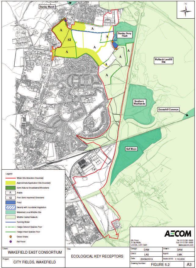
12 Ecology and Nature Conservation An ecological assessment has been undertaken to determine the ecological value of the application site at City Fields and to assess the potential impact of the proposed works on the habitats and species identified within the 2km Study Area. disturbance (lighting, noise, pets), risk of pollution, potential changes in water levels in the adjacent LWS and fragmentation of habitats that will result from the development. The assessment was based on a desk-based study and numerous field surveys to identify key ecological features at the site. Surveys were undertaken for amphibians, badger, bats, birds (wintering and breeding), brown hare, invertebrates (butterflies and dragonflies), otter, reptiles and water vole, in addition to an Ecological Walkover and Extended Phase 1 Habitat Survey. Organisations such as West Yorkshire Ecology and Natural England have been consulted as part of the assessment process. The application site is not subject to any statutory or non statutory nature conservation designations. However a number of non statutory sites are located within the 2km Study Area, including Stanley Ferry Flashes Local Wildlife Site (LWS) approximately 0.5km east of the application site and a section of the Wakefield Wildlife Habitat Network (WHN). With the implementation of mitigation measures, the impact of the proposed development works on the local ecology of the site will be reduced. The bat roost identified will be retained and measures implemented to avoid its disturbance. Habitat removal will be the minimum required to facilitate the works and retained vegetation will be protected. Works will be timed to avoid the most vulnerable periods for protected species identified on site and measures will be implemented to ensure that protected species are avoided or moved out of the working area before works commence. Mitigation will also include gapping-up retained hedgerows and the provision of green space and infrastructure creating green corridors to retain connectivity of habitats within the site and with the surrounding areas; native species found locally in the area will be used in the landscaping wherever possible. There will be a phased loss of arable, poor semi-improved grassland, scattered tree and species poor hedgerow habitats during the construction period which will have a Minor Adverse impact pre-mitigation. The faunal species identified within the application site and adjacent areas which will be affected are grass snake, water vole, breeding/wintering birds and bats; a Negligible to Minor Adverse impact is anticipated on these species pre-mitigation. The impact of the proposed works during the operational phase has been assessed as between Moderate to Minor Adverse pre-mitigation. This is due to the increased In conclusion, with mitigation measures implemented, the overall ecological significance of the impacts of the proposed development are assessed as being between Minor Adverse and Negligible for the construction phase, and Negligible for the operation phase. The cumulative impacts associated with known relevant planning applications in the 2km Study Area have been considered and it is concluded that there will not be a significant negative cumulative impact on ecological receptors providing that appropriate mitigation measures are implemented for each application. 12
13 13
14 Flood Risk and Drainage During preparation of the environmental statement, the phase 1 flood risk assessment (FRA), and the drainage strategy, consultation has been held with: The Environment Agency Yorkshire Water Ltd Wakefield MDC Drainage Engineer The development receptors which are discussed in the paper include: Sewerage Treatment Works Ground Aquifer Existing water bodies and drainage ditches. Existing properties in the vicinity of the site. Proposed properties on the development. The base line state of each receptor has been identified, and used to assess the potential impact of proposed development during both the construction phase and the completed scheme (operation phase). Prior to mitigation the significance of impacts during construction range from minor adverse to moderate adverse and during operation negligible to moderate adverse. Mitigation measures have then been identified to address the adverse impacts, with the aim of reducing flood risk. The mitigation measures which are discussed in the technical paper and the FRA, include: Restriction of surface water discharge from the proposed sewers, at a rate which mimics the Greenfield site. This will require storage of rain water in basins and underground structures, which has been discussed with both YWL and Wakefield MDC Drainage Engineer. Compliance with all YWL requirements relating to the design and installation of drainage systems, and also within the capacity of existing drainage which has been identified by YWL. Compliance with YWL will ensure that the existing sewage network is not overwhelmed, and that the proposed sewer network exceeds current standards. Stipulating that the construction site must use suitable fuel storage facilities, complete with bunding and wash down facilities. Protection of existing water bodies during the construction stage, with measures to prevent construction debris and overland flows running into the existing bodies. These measures reduce the significance of the impact of the development to negligible at both construction and operation phases, except for the increase in foul flow which remains minor adverse, although measures will be in place to ensure capacities within the public sewer network are not exceeded. The flood risk and drainage paper also considers how the development may impact on any future development (the cumulative effects). The application of a drainage strategy for phase 1, which adopts the mitigation measures as agreed with YWL and WMDC has been shown to have a negligible impact on the cumulative development. This negligible impact is justified due to the aim of mimicking the way in which the undeveloped site deals with surface water drainage. 14
15 Air Quality The potential effects of the proposed development with proposed mitigation on local air quality sensitive receptors are considered with respect to existing planning policies. Additional mitigation measures have been recommended where appropriate in order to minimise the potential for adverse residual effects from being experienced by sensitive receptors during the construction and operational phases of the proposed development. In general, construction activities have the potential to generate fugitive dust emissions as a result of demolition, construction, earth works or trackout of material. For the proposed development, the concentrations of any airborne particulate matter generated by these activities would be controlled using on site management practices to the extent that the proposed development should give rise to minor adverse to negligible effects on dust deposition rates at the nearest sensitive receptors. The impact of fugitive emissions of PM10 at these receptors with proposed mitigation applied would also be minor adverse to negligible. Overall the effect of fugitive emissions of particulate matter (dust and PM10) from the proposed works is considered to be not significant with respect to potential effects on health and amenity. For Phase 1 and 2, in the proposed opening year, there are no predicted exceedances of the annual mean objective values for nitrogen dioxide, particulate matter or fine particulates, nor does the predicted number of days where the 24 hour PM10 concentration is above 50 µg/m3, exceed the objective at any receptor. The overall impact of the proposed development on local air quality at Phase 1 and 2 is not considered to be significant. As such the development is unlikely to contravene Wakefield Metropolitan District Council s local planning policy. For the Cumulative Phase in 2031, while there are some large beneficial and medium adverse changes across the model domain, the NO2 concentrations are well below the annual mean objective, and as such these changes are not considered to be significant. Vehicle fleet information used to derive the emission factors for the modelled year (2031) is highly uncertain. In addition to this, the change in road traffic that has been assessed includes all LDF schemes and other major developments as well as Cityfields and the WERR. Therefore the results of this assessment are indicative and do not reflect the impacts of the Cityfields scheme alone. 15
16 Socio Economic The proposed residential development brings a series of significant benefits to the Wakefield East and Stanley & Outwood East wards, Wakefield and the Region. The overall impact of the proposal in terms of socio-economic issues is considered to be negligible to minor / moderate beneficial due to the delivery of new homes and affordable housing the positive effects that the development will have to the local community and economy. The provision of new housing within the Wakefield East and Stanley & Outwood East wards could have a moderate beneficial impact upon the current migration rates and expected levels of population growth as more homes will be made available to the local population. The delivery of a range of housetypes will be provided on the site to respond to the existing housing market need within the area which again provides a positive impact on the need for housing within the area. Delivery of an affordable housing contribution if viable could assist in addressing the need within the area. Employment opportunities for the local population will be provided through the proposed residential scheme. The Technical Paper indicates that it is expected that the scheme will deliver 750 temporary direct jobs (construction) and a range of spin off jobs. The proposed development generates additional demand for local services which would have a potential positive impact on the employment of additional staff by existing businesses in the locality. The proposed project could generate 12,747,000 of net additional Gross Value Added within Wakefield per annum. This relates to construction jobs which will be for a finite period. The total household expenditure the scheme can achieve is 10,662,600 however this would not be additional expenditure as some people would not be completely new households. The proposed development could provide the Local Authority with 3,646,578 over 6 years as part of the New Homes Bonus which could assist in delivering housing growth within Wakefield. The scheme has the potential to generate 515, in additional Council Tax payments to Wakefield Council. The development would provide Phase 1 of the Wakefield East Relief Road which will reduce congestion in central Wakefield. The scheme opens the Wakefield East and Stanley & Outwood East wards and presents its assets to the wider area which could in turn benefit the local economy. The creation of a series of new footpaths and cycleways and the provision of new areas of public open space for use by both the existing community and new residents to the site will encourage activity, walking and cycling. The redevelopment of the site for 500 new homes within Wakefield will inevitably impact upon community infrastructure within the locality in particularly in terms of the of available health and education services. Whilst there is some health capacity at present, further discussions will be needed with health providers in the longer term. Delivery of an education contribution will assist in addressing education capacity issues within the area. The wider City Fields masterplan identifies proposed land made available for a primary school and opportunities for Health facilities to be accommodated within the City Fields wider site allocation. The residential development would have an overall beneficial effect in terms of Wakefield East and Stanley & Outwood East wards socio economic impact due to the local and borough wide benefits which would be delivered. 16

17 Utilities, Energy and Waste The environmental impacts and effects of the Utilities and Energy including waste impacts associated with the proposed development have been considered. A comprehensive service search was carried out to check the location of existing services apparatus in the vicinity of the site following which enquiries were made to obtain proposals for new services supplies (electricity, gas, water, telecommunications and foul water drainage) for the development as well as any possible diversions and to enable an assessment to be made of the environmental impacts. The conclusion of this exercise was that, after taking into account the measures envisaged, the effects of utilities both during construction and operation were considered to be negligible. A CO2 Emissions Reduction assessment was undertaken and the conclusion of this exercise was that with the construction of properties using a combination of embedded fabric efficiency measures this would reduce carbon emissions such that the environmental impact of the services infrastructure and energy would be negligible. Such measures will include: reduction through fabric first improvement measures Soft landings approach to handover Energy monitoring Voltage optimization An investigation into Water Reduction Measures was carried out which concluded that water efficiency measures would provide betterment over Building Regulations requirements and significantly reduce water usage by incorporating low water use fixtures and fittings within dwellings and thus promote resource conservation. Receptor Plan 17

18 Noise and Vibration To determine the existing noise climate at the new site, ambient noise monitoring was undertaken at six long-term locations and three short-term locations representative of either the existing or the proposed residential receptors. require mitigation in the form of 1.8m boundary fencing, and a small number remain requiring additional mitigation. Internal noise levels within the proposed residential properties can be reduced to an acceptable range and comply with the criteria given in the relevant guidance. In the majority of cases this can be achieved using standard doubleglazing, and acoustic trickle ventilation. Glazing and ventilation of a higher specification has been recommended for certain properties fronting onto the proposed Relief Road. Construction Receptor Locations (C1) Operational Receptor Location (R1-R12) Vibration Receptor Location (VIB1) (NOT TO SCALE) No acoustic data for the 2no. substations associated with Phase 1 of the development was available. However, limits for fixed plant noise at surrounding sensitive receptors were set, based on the methodology provided in BS 4142 and the measured data. The required rating level at the closest receptor would be 45 db L Aeq during the daytime, 40 db L Aeq during the night-time. With mitigation, the significance of construction noise effects was generally rated as negligible or minor adverse for the majority of activities at the chosen receptors, and it should be noted that these effects are temporary by their very nature. The predicted vibration level from piling fall well below the criteria for building damage at the closest sensitive receptor. This level of vibration level is unlikely to be perceptible. The predictions were based on the closest approach; therefore they should be treated as a worst-case scenario and should be reviewed once the final method of piling is known. Sources of vibration introduced to the site during construction work will last only for the duration of the construction period. Acceptable daytime noise levels in rear gardens can be achieved in the majority of proposed plots. Certain plots For the majority of road links, the operation of the Phase 1 development results in no potentially significant changes in road traffic flows. All but one links with the development in place for Phase 1 have negligible increases in noise levels. The exception is Parkside Lane with a significance of minor adverse at the worst affected property due to operation of the first phase of the Relief Road. Mitigation in the form of a 2.5m bund/barrier along the Relief Road will reduce the significance to no greater than minor adverse. For the majority of road links, the operation of the Phase 2 development results in no potentially significant changes in road traffic flows. The worst case effects are no greater than minor adverse. The indication is that no permanent sources of environmental vibration will be introduced at the development. Consequently there will be no residual vibration impacts. 18
19 Geology and Ground Conditions With the exception of a possible pit/quarry in the wets historically no significant development has taken place at the site. Middle Coal Measures strata (undifferentiated mudstone, siltstone and sandstone) underlie the majority of the site with Crigglestone Rock (sandstone) in the southwest. Made ground typically comprising Ash & Clinker and Granular strata is predominantly restricted to, and deepest in, areas of backfilled ponds and a former pit/quarry in the west of the site. Natural Ground on the site is typically firm or stiff clays (Weathered Coal Measures) which grade into Mudstone, Sandstone or Siltstone at shallow depth, typically from around 2m to 3m. Inorganic contamination has been recorded within the made ground encountered in the northwest of the site together with the identification of trace quantities of asbestos fibres. A former colliery was located immediately south-east of the application site. The Coal Authority Mining Report for the wider site area states that the site is within the zone of influence of 6 seams of coal between 70m and 510m depth last worked in Movement from these workings should have ceased by now. No shallow seams of economic significance are believed to underlie the application site. In terms of hazardous gas, no methane was detected within any of the monitoring wells. Conventional reinforced strip foundations placed within the natural deposits (minimum 600mm in granular strata and 900mm in cohesive soils) are considered the most feasible founding solution for proposed two storey dwellings at this site. Deeper trenchfill footings or piles will be required where localised deep made ground is encountered (northwest of the site) although this is likely to affect a relatively small number of plots. Piles are also recommended for plots in the north-east of the site underlain by First River Terrace deposits due to localised soft clays/silts, the high water table and presence of running sands. Foundation depths may be reduced to 450mm depth where competent rock is encountered. Groundwater seepages were recorded in 28 of the exploratory holes between 0.6m and 6.3m depth predominantly in the First River Terrace Deposits in the north-east of the site where running sand was encountered. Any seepages within the Coal Measure strata across the remainder of the site are likely to be slow due to lower permeability, although any excavations left open for a significant period of time may become waterlogged. There is a negligible effect to both surface and ground water both during construction and in the operational phase. No sources of mobile contamination have been identified and the nearest receptors are some distance from the site. Care will be required during construction to minimise surface run-off. Operational highway drains will require interceptors. Minor contamination has been noted in isolated locations on site. During construction dust suppression and appropriate personal protective equipment will reduce the impact to negligible levels. The impact on the operational phase is also negligible as contaminated soils will be isolated. The effects are negligible in both the construction and operational phases. During construction gas will be freely venting to atmosphere, operational buildings will be constructed with suitable gas protection measures. Earthworks during the construction phase may create dust that will be suppressed. 19
20 Cultural Heritage The potential effects of the proposed development (with mitigation) on the identified cultural heritage resource are considered with respect to legislation, guidance documents and existing planning policies. Mitigation measures have been recommended where appropriate in order to minimise the effect on sensitive receptors during the construction and operational phases of the proposed development. No designated assets have been recorded within Phase 1 and 2 of the development area but a number have been recorded within the wider area including Stanley Ferry Aqueduct which is classed as a scheduled monument and is listed at Grade I. This is located to the east and was constructed to carry the Aire and Calder Navigation Cut over the River Calder. A total of 14 listed buildings/ structures lie within the area surrounding the application site which are listed at Grade I, II or Grade II*. These largely relate to the stately homes or halls and the Aire and Calder Navigation System to the east. None of the assets recorded lie within a Conservation Area. Situated adjacent to the western boundary of the application area are two listed buildings namely Clarke Hall and Stanley Hall. The grade II* listed Clarke Hall which is associated with grade II Iisted forecourt walls and mounting block dates to the late 17 th century. The building is a set within gardens extending to the south which are surrounded by flanking walls. To the north are a number of outbuildings, converted to office use. A short distance to the north of Clarke Hall is Stanley Hall which is listed at grade II. The present hall represents a rebuilding of by its new owner Benjamin Heywood who purchased the site in 1802 after a devastating fire. When built, it was situated within a large area of parkland extending to the east into the application site. This area is now in agricultural use and the building is in use as a nurses home. Three listed assets namely Clarke Hall, its forecourt walls and Stanley Hall will be indirectly affected as construction will generate visual impacts on the assets. There will also be an associated increase in noise levels resulting from construction traffic and activities. This is reduced to some extent by the retention of the existing vegetation screening; however, the impact on Clarke Hall and Stanley Hall remains as minor negative. The impact would be temporary. The effect is therefore considered to be moderate adverse. The effect from operation is also assessed to be moderate adverse. The proposals will involve the development of previously open ground which will impact on the setting of the hall through the erosion of the previously open landscape and the introduction of new noise impacts. This is mitigated to some extent by the village design, with new buildings balanced alongside areas of open greenspace. Any impacts should also be seen in the context of the existing erosion of land immediately adjacent to the hall, however, there remains a minor negative impact from development, resulting in a moderate adverse effect. To protect the historic buildings adjacent to the application site during construction, hoardings will be erected which will reduce the effects of dust and noise pollution. However, it is not anticipated that these will decrease the overall effect of the works. The design of the proposed development has taken into consideration the sensitivity of its location. In particular, the inclusion of a formal park area between Clarke Hall and Stanley Hall are effective in retaining the relationship between the two historic assets. Efforts have also been made to retain existing vegetation where this provides a screen to the proposed development. The development has been assessed with these measures already incorporated; therefore, no specific mitigation is proposed. 20

21 Cultural Heritage Construction within the wider allocation site is not expected to commence until after On this basis there will be no cumulative impacts on the identified built hertiage resource. A total of 31 non-designated assets have been identified within the study area. In addition to this a number of archaeological features have been identified from the geophysical survey undertaken within the application site. Assessment of a range of sources including those held by the West Yorkshire Historic Environments Record and local depositories have determined that within the study area there is some prehistoric/ Roman activity. To assess the possibility of such evidence occurring within the site a geophysical survey was undertaken by Phase Site Investigation between May and June Recorded were number of archaeological features some of which are likely to relate to prehistoric settlement and agricultural activities based on their character. Others are indicative of Roman agricultural field systems and possible associated settlement activity. The prehistoric/ Roman archaeology revealed within the application site will be directly affected by construction activities. This is rated as a high adverse effect, however, with mitigation this will be reduced to moderate adverse. The ponds associated with Stanley Hall will also be directly impacted but with mitigation this results in a minor adverse effect. The aim of the aforementioned mitigation is to preserve the archaeology identified by record. To further inform the strategy for this additional evaluation will be undertaken. The scope of these works will be agreed with the West Yorkshire Archaeology Advisory Service (WYAAS) through the provision of a Written Scheme of Investigation which will be agreed in advance with WYAAS. The geophysical survey undertaken along the Wakefield East Relief Road Extension and the suds drainage corridor has identified the presence of archaeological features. These are likely to be associated with those recorded within the application site. Subsequently development associated with the wider allocation site will result in a direct cumulative impact on the identified archaeological remains. The resultant loss of the resource is not considered to represent an impact above that for the application site and thus is considered to remain as moderate adverse. 21

22 Landscape and Visual Impact The Landscape and Visual Impact Assessment assesses the potential effects of the proposed Development on the character of the landscape for the immediate site and the wider landscape context, and also the visual amenity of receptors with views of the proposed Development. Landscape receptors identified include; National Character Areas, Local Character Assessments and the Character of the Application Site. Visual receptors identified include; Views from residential properties, Recreation Receptors, Place of work receptors, and Views from Roads. A methodology for the approach to this assessment has been prepared in accordance with current professional best practice, and types of receptors are assessed as either potential impacts to the landscape as a resource or to views and visual amenity. The number and type of identified potential landscape and visual receptors were agreed with the local planning authority and Natural England who are statutory consultee for landscape and visual matters. The identified landscape and visual receptors have been assessed for their sensitivity to change by the proposed development. The degree of change caused by the proposed Development to either the landscape or visual receptor has been assessed in relation to the existing situation during construction and operation (when the residential properties are being lived in). The potential impacts have been assessed with regard to their importance (or value) ranging from international (e.g. World Heritage Site) to local/neighbourhood importance scale. Where significant impacts are predicted during construction or operation, mitigation measures are proposed to reduce the impacts. In the context of Environmental Impact Assessment, significant impacts which remain following mitigation are recorded as Residual Impacts. During the construction phase (prior to mitigation) there were no landscape receptors identified as having significant effects. Visual Receptors R1, R2 (residential) and R5 (public footpath) were identified as having moderate adverse significant effects and therefore deemed significant and requiring mitigation measures. During the operational phase (prior to mitigation) there were no landscape receptors identified as having significant effects. Visual Receptor R1 was identified to remain to experience a moderate adverse effect and therefore an effect deemed significant and requiring mitigation measures. Where moderate adverse or above significance of effects are assessed (either during construction or operation) mitigation is required. The mitigation proposed for both the construction and operation phases include tree planting, buffer planting and woodland understorey planting. It is proposed that mitigation measures and infrastructure planting are implemented during the construction phase, however due to the nature of the mitigation in the form vegetative screening mitigation will take several years as the planting grows and establishes. Therefore there will remain significant residual impacts for visual receptors R1, R2 and R5 during construction. View looking south from open space on the north side of Bar Lane Gateway 22

23 Landscape and Visual Impact It is considered that following the implementation of the mitigation proposals during the construction phase and the subsequent growth of the vegetation during the construction phase that the mitigation will become effective for the operational phase and therefore there will be no significant residual impacts remaining to the visual receptors during the operational phase. The proposed Development will change the existing agricultural fields to a residential area. Important trees and hedgerows will be retained and enhanced as part of a comprehensive landscape infrastructure planting strategy, which will also help to soften the built form and assimilate the development into the wider landscape context. There will be a large change to the nature of the proposed Application site, although this will occur over phases. During this period the implementation of soft landscaping works as each phase will be completed, will further help to assimilate the Development into the wider landscape context. This will be further aided by the implementation of advanced planting works within the public open space in advance of phases yet to be constructed. These planting proposals will also reduce potential impacts to the visual amenity of residential and footpath users with views towards the site from the east on higher topography. There will be no residual landscape or visual impacts. All key receptors associated with landscape and visual impact are identified on the plan within Appendix
24 Interaction of Effects of Construction TOPIC IMPACT MITIGATION C O N Socio Economic Creation of construction jobs / indirect jobs Increased expenditure and demand for local services Population increase Additional GVA Beneficial so no mitigation proposed S T R U Earth works and construction activity Dust Noise and vibration due to construction works Increase in construction traffic Change in traffic emissions Disturbance to local community Road safety Provision of a Construction Management Plan Minimising dust generating activities and dust suppression Re-use of material on site Gas protection measures to housing C T I Utilities Structural damage Disturbance and spread of Himalayan balsam Ground gas Waste Water pollution Flood risk Best Practice Measures Implementation of EA Pollution Prevention Guidance Site screening / hoardings Early provision of acoustic barrier to boundary with the Hospice building O Modification of drains Services to be designed and installed in common trenches N Noise and Air Quality Temporary bunding to prevent overland flow during site striping Changes in water level at the Stanley Ferry Flash Ecological watching brief where required I Flood Risk / Drainage Loss and disturbance of trees and vegetation Phasing of works and seasonal timing of works M P A C T S Ecology Landscape and Visual Impact Cultural Heritage and Archaeology Loss and fragmentation of habitats Loss of arable land Storage of materials Fragmentation of habitats Disturbance of species Changes in views Impact on listed buildings / structures (setting of Stanley Hall, Clarke Hall and Forecourt walls to Clarke Hall Impact on Prehistoric / Roman agriculture and settlement activity Buffer planting New planting throughout site (advanced infrastructure planting and woodland understorey planting) Retention of existing tree belts and hedgerows Site screening / hoardings Construction Management Plan (location of site hoardings and site compounds) Protective fencing for trees protection Further mitigation to be agreed with WYAAS (archaeological) 24
25 Interaction of Effects of Operational TOPIC IMPACT MITIGATION O P E R T Highway Safety Increased traffic flows / traffic on network Driver Stress Increased traffic on local network Traffic emissions Increase in hard surfaces increased surface water run off Water quality Increased demand on water supply Increase demand in foul water disposal Production of a Travel Plan Proposed Infrastructure Improvements Improved pedestrian / cycle linkages Diversion of bus through the site Provision of bus stops within the site Improved linkages throughout the site to wider area Off-site highway improvements I O N A N L I M P A C T S Development: Up to 500 residential dwellings New access road (including first phase of Relief Road) Two junctions onto Aberford Road, including a new roundabout junction Public Open Space Landscaping and ecological works Gabion Structures Drainage features Two electrical substations Acoustic barrier Vehicle, pedestrian and cycle circulation Change of use of agricultural land to land associated with hospice Flood risk Risk of pollution to Stanley Ferry Flash Change in water levels to Stanley Ferry Flash Increase in population Reduced out migration for employment Increased employment opportunities Provision of housing to meet demand Increased GVA Retail provision New Homes bonus Increased Council tax Payments Increased household expenditure Increased demand for existing facilities and services Creation of new open space Impact on Education and Health provision Disturbance to habitats / loss of habitat Fragmentation of habitats Pollution or damage to habitat Spread of invasive species Change to landscape and views Impact on setting of Listed Buildings (Clarke Hall, Clarke Hall Walls and Stanley Hall) Impact on existing residential amenities Increased load on local utility services Increase waste to go to landfill SUDs and drainage strategy including on-site attenuation Restricted surface water run off rates The two stages of water treatment will include the use of trapped gullies, attenuation which will promote sediment settlement. Beneficial impact no mitigation proposed Education Contribution Habitat protection, maintenance and retention Tree retention and new planting Control and eradication Appropriate landscaping Management Company Boundary screening and façade treatments Acoustic barriers Consideration of site design, layout and orientation of dwellings Waste Management Plan Waste bins Fabric efficiency and water reduction measures designed into dwellings 25

26 Cumulative Effects There are a number of developments that need considering given the likely impact they will have cumulatively with the application development. These include developments with planning permission but which are not yet built; sites allocated for development or any other known future proposals. The following list have been agreed with the Council as part of the Scoping process. The developments considered as cumulative are set out below: Welbeck Landfill Restoration City Centre Action Plan Areas Remaining Phases of Merchant Gate Policy CW20 Remaining Phases of Wakefield Waterfront Policy CW21 Other LDF Development Sites (identified within the Site Specific Policies Local Plan (September 2012)) Wider site allocation Special Policy SPA2, Wakefield East Land at Snow Hill, Wakefield Special Policy SPA1 Land East of Newton Hill Junior and Infants School, Newton Hill (Fieldhead) Policy HS1 Pinderfields Hospital (West), Wakefield Policy HS2 Ivy Lane, Eastmoor Policy HS3 North of Ruskin Avenue and Adjoining Land, Wrenthorpe Policy HS20 Land at Leeds Road, Newton Hill Policy HS75 Victoria Way, Outwood Policy HS74 Former Newmarket Colliery, Stanley Policy ES10 Cold Store, Newmarket, Rothwell The Applicants are aware of the Government s HS2 proposals which are currently at consultation stage. However the HS2 proposals are not a material planning consideration in determining any planning applications until such time as a Safeguarding Direction is issued. Such a Safeguarding Direction is unlikely to come forward for the next 18 months to two years. The HS2 proposals are not therefore to be considered in terms of the cumulative impact at this stage. Overall it is considered that the cumulative development, post mitigation, would have an overall beneficial effect due to the local and borough wide benefits which would be delivered, including increased employment and expenditure in the area and opportunities for regeneration and investment. 26
27 Conclusion The main purpose of the ES is to provide an objective assessment of the Environmental Impacts of the proposed development. This Non-Technical Summary provides a summary of the main issues identified within the ES Part 1 and ES Part 2. The separate Technical Papers within the ES Part 2 of the Environmental Statement provides a detailed analysis of impacts and mitigation of the development during the construction and operational phases against a range of topics including: Geology and Ground Conditions Traffic and Transportation Flood Risk and Drainage Landscape and Visual Impact Ecology and Nature Conservation Socio-economic Noise Air Quality Cultural Heritage Utilities, Energy and Waste The ES Part 1 report aims to provide an overview of the predicted effects and how it is proposed to mitigate the impacts. It should be noted that the information submitted for this planning application is extensive given the nature of the site, however, the detailed mitigation strategies will be controlled via the use of planning conditions and the Section 106 Agreement. As a whole, any potential environmental impacts are negligible or beneficial and at worst minor adverse. Where these are during construction, these potential environmental impacts will be temporary and largely intermittent as the site is developed. Where the impacts are greater, they are no more than moderate adverse. This is in respect of landscape and visual impact during construction for some of the views from neighbouring properties and public footpaths; as well as cultural heritage and the impact on pre-historic / Roman agricultural and settlement activity during construction and the impact on the setting of the adjacent Listed Buildings, Clarke Hall and Stanley Hall during both construction and operation. However mitigation is inherent in the design of the proposals and is to be implemented during construction and operation to minimise the impacts of the proposals as far as possible. The report also assesses the potential for the interaction of effects and concludes that the adverse interaction of impacts in and around the site will occur at its greatest during the short term period (construction and initial phase of operation). It is however considered that the mitigation proposed as part of this environmental assessment is sufficient to deal with these impacts which would be controlled by the use of planning conditions and S106 legal agreement should planning permission be granted. Benefits in the short term relate to direct and indirect employment related to the construction industry. In the longer term, there are benefits resulting from the proposals such as the remediation of a contaminated site, provision of housing to meet need and encouragement of inward investment. Cumulative impacts are not considered to be significant and in the majority of cases, negligible. There are positive cumulative impacts in terms of socio economic, traffic and transportation. Noise and cultural heritage impacts will be the greatest cumulative impacts, but these will be no greater than those assessed for the application site (minor adverse and moderate adverse respectively) and measures would be put in place to mitigate impacts as far as possible to keep the resulting environmental impacts to a minimum. There are therefore not considered to be any potential environmental impacts that cannot be suitably mitigated and which would prevent the proposals from being granted planning permission. 27

28 Spawforths Junction 41 Business Court, East Ardsley, Leeds, West Yorkshire. WF3 2AB t: , f: , Spawforths is a trading name of Spawforth Rolinson Ltd. Incorporated in England, Company Registration Number
Ashfields, Normanton. Environmental Statement Non Technical Summary
 Ashfields, Normanton Taylor Wimpey Environmental Statement Non Technical Summary Spawforths has been accepted as a registrant to the Institute of Environmental Management and Assessment's (IEMA) EIA Quality
Wakefield Eastern Relief Road. Wakefield Metropolitan District Council Environmental Statement Non Technical Summary
 Wakefield Eastern Relief Road Wakefield Metropolitan District Council Environmental Statement Non Technical Summary Spawforths has been accepted as a registrant to the Institute of Environmental Management
Longbridge Town Centre Phase 2 Planning Application
 Longbridge Town Centre Phase 2 Planning Application Non-Technical Summary of the Environmental Statement December 2013 Introduction A full application for Planning Permission has been submitted to Birmingham
Grantham Southern Quadrant Link Road Environmental Statement
 Grantham Southern Quadrant Link Road Environmental Statement Non Technical Summary Introduction Lincolnshire County Council (LCC) is submitting a planning application for the proposed implementation of
University Park, Worcester Non Technical Summary December 2011
 University Park, Worcester Non Technical Summary December 2011 Introduction UW Wrenbridge LLP, a Joint Venture Company of the University of Worcester and Wrenbridge Land Ltd (the Applicants ) intend to
ABBEY MANOR GROUP/SAINSBURY S SUPERMARKETS LTD
 ABBEY MANOR GROUP/SAINSBURY S SUPERMARKETS LTD Mixed Use Development including Business Park and Foodstore Land at Bunford Park, Bunford Lane, Yeovil Environmental Statement: Non-Technical Report June
Sustainability Statement. Whitby Business Park Area Action Plan
 Sustainability Statement Whitby Business Park Area Action Plan November 2014 Contents Page 1. Introduction 1 2. Scoping 3 3. Sustainability Appraisal of Options 6 4. Assessment of Draft Area Action Plan
NON-TECHNICAL SUMMARY
 Proposed Sand and Gravel Extraction and Associated Processing Operations with Restoration to a Mixture of Agriculture and Nature Conservation including Areas of Shallow Water at Hedgeley, Northumberland
WELCOME. Land North of STEVENAGE. We would like to thank you for attending our public exhibition today.
 WELCOME We would like to thank you for attending our public exhibition today. The purpose of this event is to share our proposals and hear your thoughts on our ideas. Members of the project team are on
BREEDON NORTHERN LIMITED
 Non Technical Summary CONTENTS 1 INTRODUCTION... 1 2 SITE DESCRIPTION... 1 3 DESCRIPTION OF THE DEVELOPMENT... 6 4 NEED FOR THE DEVELOPMENT... 8 5 KEY ISSUES CONSIDERED IN THE ENVIRONMENTAL IMPACT ASSESSMENT...
Comments on the proposed scope are requested from WCC/NBBC officers to be provided to SLC Rail by 25 th March 2016 and sent to
 Introduction WCC have indicated that in advance of the surveys and assessments being undertaken consultation should be undertaken with technical officers of both Warwickshire CC and Nuneaton and Bedworth
Replacement Golf Course Facilities and Residential Development, Churston. Environmental Statement Non-Technical Summary
 Replacement Golf Course Facilities and Residential Development, Churston Environmental Statement Non-Technical Summary July 2011 Reproduced from the Ordnance Survey s map with the permission of the Controller
LAND AT MIDDLETON STONEY ROAD AND HOWES LANE, BICESTER ENVIRONMENTAL STATEMENT NON-TECHNICAL SUMMARY. June 2017 Our Ref: Q70433
 LAND AT MIDDLETON STONEY ROAD AND HOWES LANE, BICESTER ENVIRONMENTAL STATEMENT NON-TECHNICAL SUMMARY June 2017 Our Ref: Q70433 Contents 1 INTRODUCTION... 2 2 SITE DESCRIPTION... 5 3 EIA METHODOLOGY...
Statement of Community Involvement LAND OFF SOUTHDOWN ROAD HORNDEAN, HAMPSHIRE
 LAND OFF SOUTHDOWN ROAD HORNDEAN, HAMPSHIRE CONTENTS Page 1. Introduction 3 2. Pre-application Discussions 4 3. The Consultation Process 5 4. Consultation Feedback 7 5. Responses to Consultation Feedback
Welcome to our Public Consultation
 About our development This exhibition gives you the chance to view and comment on our emerging plans for a proposed residential development located on land to the West of Alwyn Road, Rugby. Welcome to
Durkar Lane, Crigglestone Taylor Wimpey UK Ltd. Environmental Statement Non Technical Summary
 Durkar Lane, Crigglestone Taylor Wimpey UK Ltd Environmental Statement Non Technical Summary Contents Introduc on... # EIA Process... # Site Descrip on... # Development Descrip on... # The Need... # Planning
ROCHFORD LOCAL DEVELOPMENT FRAMEWORK: Sustainability Appraisal/ Strategic Environmental Assessment. Rochford Core Strategy Preferred Options Document
 ROCHFORD LOCAL DEVELOPMENT FRAMEWORK: Sustainability Appraisal/ Strategic Environmental Assessment Non Technical Summary Rochford Core Strategy Preferred Options Document October 2008 SUSTAINABILITY APPRAISAL
Wyvern Park Skipton Environmental Statement. Non-technical Summary - April 2015
 Wyvern Park Skipton Environmental Statement Non-technical Summary - April 2015 BWB Consulting Ltd Whitehall Waterfront 2 Riverside Way Leeds LS1 4EH Telephone: +44(0)113 233 8000 Copyright This Report
Cardiff International Sports Village Waterfront Development Volume IV : Non-Technical Summary of the Environmental Statement
 Greenbank Partnerships Ltd October 2012 Cardiff International Sports Village Waterfront Development Volume IV : Non-Technical Summary of the Environmental Statement Environmental Statement - Non Technical
Former RAF Sealand Site EIA
 Praxis (Holdings) Ltd. Former RAF Sealand Site EIA Environmental Statement - Non Technical Summary February 2012 in association with P a g e 1 1. Introduction Praxis (Holdings) Ltd. is applying to Flintshire
Pontefract Road, Purston, Featherstone Taylor Wimpey UK Ltd. Environmental Statement Non Technical Summary
 Pontefract Road, Purston, Featherstone Taylor Wimpey UK Ltd Environmental Statement Non Technical Summary Report Author... Alastair Cliffe / KM Report Date... September 2012 Project Number... 3472 Document
Moat Lane Regeneration Project Environmental Statement
 AECOM Environment Towcester Regeneration Ltd. October 2012 Moat Lane Regeneration Project Environmental Statement Non-Technical Summary Prepared by:... Checked by:... Sophie Collins Scott Wilson Environmental
WELCOME GYPSY LANE. Wider Site Location plan. Proposals for the development of LAND OFF FOXLYDIATE LANE WEBHEATH. Proposals for the development of
 WELCOME The developers are preparing an outline planning application for a residential led development and need the community s views in order to develop the proposals further WHAT IS PROPOSED? A high
Public Consultation. Land at Monks Farm, North Grove. Welcome
 Welcome Welcome to our public exhibition for development on Land at Monks Farm, orth Grove. Gallagher Estates and Gleeson Strategic Land are preparing an outline planning application for new homes, open
Welcome to our exhibition
 Welcome to our exhibition The Homes & Communities Agency (HCA) welcomes you to this public exhibition explaining our proposals for the redevelopment of the former Lea Castle Hospital site. About the Homes
South Whitehaven, Cumbria EIA
 South Whitehaven, Cumbria EIA Environmental Statement - Non Technical Summary June 2013 in association with 1. Introduction Story Homes is applying to Copeland Borough Council (CBC) for a new residential
Development of land adjacent to Braggs Farm Lane and Rumbush Lane, Dickens Heath. Welcome. Today s exhibition. The proposal site
 Welcome Welcome to this event to discuss the development of land adjacent to Braggs Farm Lane. is currently in the preliminary stages of designing proposals to sensitively develop this site with high-quality
Rochford District Council Allocations Development Plan Document: Discussion and Consultation Document Sustainability Appraisal
 Option SWH1 Balanced Communities Option SWH1 1 To ensure the delivery of high quality sustainable communities where people want to live and work Will it ensure the phasing of infrastructure, including
The Town and Country Planning (Environmental Impact Assessment) (Wales) Regulations 2016, Regulation 13 Scoping Opinion
 (Wales) Regulations 2016, Regulation 13 Scoping Opinion") Mr Graham Clark Berrys Newchurch Farm Kinnersley Hereford HR3 6QQ BY EMAIL The Town and Country Planning (Environmental Impact Assessment) (Wales) Regulations 2016, Regulation 13 Scoping Opinion SC/2017/0001
Mr Graham Clark Berrys Newchurch Farm Kinnersley Hereford HR3 6QQ BY EMAIL The Town and Country Planning (Environmental Impact Assessment) (Wales) Regulations 2016, Regulation 13 Scoping Opinion SC/2017/0001
SOUTH EAST LINCOLNSHIRE LOCAL PLAN: HOUSING PAPER DONINGTON (JUNE 2016)
") SOUTH EAST LINCOLNSHIRE LOCAL PLAN: HOUSING PAPER DONINGTON (JUNE 2016) 1 DONINGTON S PLACE IN THE SPATIAL STRATEGY 1.1 Policy 2 of the South East Lincolnshire Local Plan 2011-2036 Draft for Public Consultation
SOUTH EAST LINCOLNSHIRE LOCAL PLAN: HOUSING PAPER DONINGTON (JUNE 2016) 1 DONINGTON S PLACE IN THE SPATIAL STRATEGY 1.1 Policy 2 of the South East Lincolnshire Local Plan 2011-2036 Draft for Public Consultation
Kibworth Harcourt. Introduction. Introduction
 Introduction Introduction Welcome to this public exhibition on the proposals for the delivery of new homes on land at The Kibworths. The purpose of today s exhibition is to give you the opportunity to
Great Easton Neighbourhood Plan Statement of Basic Conditions
 Great Easton Neighbourhood Plan 2017-2031 Statement of Basic Conditions OCTOBER 2016 GREAT EASTON PARISH COUNCIL Contents 1.0 Introduction....Page 2 2.0 Summary of Submission Documents and Supporting Evidence..
LAND SECURITIES REDEVELOPMENT OF NEWNHAM COURT SHOPPING VILLAGE, MAIDSTONE
 LAND SECURITIES REDEVELOPMENT OF NEWNHAM COURT SHOPPING VILLAGE, MAIDSTONE Land at Environmental Statement: Non-Technical Summary Introduction Land Securities plc is applying to Maidstone Borough Council
LAND AT HOWES LANE, BICESTER ENVIRONMENTAL STATEMENT NON-TECHNICAL SUMMARY. March 2017 Our Ref: Q70433
 LAND AT HOWES LANE, BICESTER ENVIRONMENTAL STATEMENT NON-TECHNICAL SUMMARY March 2017 Our Ref: Q70433 Contents 1 INTRODUCTION AND SITE DESCRIPTION... 1 2 EIA METHODOLOGY... 5 3 ALTERNATIVES... 6 4 DESCRIPTION
London Road, Derker. Non Technical Summary. Introduction
 London Road, Derker Non Technical Summary Introduction The Oldham Rochdale Housing Market Pathfinder was set up to tackle longstanding problems of poor quality housing and to provide the framework for
Welcome. Site/11/04. Site/11/03. Proposed Site. 11,400 new homes needed in east Cambs
 Welcome Welcome to our consultation on our proposals for new homes on land north east of Soham Road, Fordham. Members of the project team are available to answer any questions you have and listen to feedback.
Environmental Statement (Volume 1) Non Technical Summary
 Non Technical Summary") Environmental Statement (Volume 1) Non Technical Summary Prepared by: The Environment Partnership Haydock Point Environmental Statement (Volume 1): Non-Technical Summary March 2017 Contents 1. Introduction
Environmental Statement (Volume 1) Non Technical Summary Prepared by: The Environment Partnership Haydock Point Environmental Statement (Volume 1): Non-Technical Summary March 2017 Contents 1. Introduction
The Place Solar Farm
 The Place Solar Farm Environmental Statement Non-Technical Summary 28 August 2014 Produced for Prepared by St John s House Queen Street, Manchester M2 5JB Contents Contents... 2 1 Introduction... 3 1.1
CENTRAL BEDFORDSHIRE COMMITTED TO WORKING TOGETHER WITH LOCAL COMMUNITIES
 WELCOME Thank you for coming to our consultation event to find out more about our emerging proposals for Hayfield Park, a residential development jointly promoted by the Hayfield Consortium: Martin Grant
SOUTH CAMBRIDGESHIRE DISTRICT COUNCIL. REPORT TO: Planning Committee 1 April 2015 Planning and New Communities Director
 SOUTH CAMBRIDGESHIRE DISTRICT COUNCIL REPORT TO: Planning Committee 1 April 2015 AUTHOR/S: Planning and New Communities Director Application Number: Parish(es): Proposal: Site address: Applicant(s): Recommendation:
Chapter 4. Route Window C12: Mile End Park and Eleanor Street Shafts
 Chapter 4 Route Window C12: Mile End Park and Eleanor Street Shafts 48 Crossrail Amendment of Provisions 4 Route Window C12: Mile End Park and Eleanor Street Shafts Location plan of Mile End Park and Eleanor
DEFGH. Crystal Place Park. Environmental Impact Assessment (EIA) Elin Thomas and Emily Low Waterman Environmental
 Elin Thomas and Emily Low Waterman Environmental") DEFGH Crystal Place Park Environmental Impact Assessment (EIA) Elin Thomas and Emily Low Waterman Environmental 10.12.07 EIA Presentation Content What is EIA? Legal Requirements Process Q&A Key Topics
DEFGH Crystal Place Park Environmental Impact Assessment (EIA) Elin Thomas and Emily Low Waterman Environmental 10.12.07 EIA Presentation Content What is EIA? Legal Requirements Process Q&A Key Topics
PERSIMMON HOMES (SW) LIMITED LAND AT ADDINGTON, LISKEARD ENVIRONMENTAL STATEMENT NON-TECHNICAL SUMMARY
 LIMITED LAND AT ADDINGTON, LISKEARD ENVIRONMENTAL STATEMENT NON-TECHNICAL SUMMARY") PERSIMMON HOMES (SW) LIMITED LAND AT ADDINGTON, LISKEARD ENVIRONMENTAL STATEMENT NON-TECHNICAL SUMMARY APRIL 2010 INTRODUCTION This document is the Non-Technical Summary (NTS) of an Environmental Statement
PERSIMMON HOMES (SW) LIMITED LAND AT ADDINGTON, LISKEARD ENVIRONMENTAL STATEMENT NON-TECHNICAL SUMMARY APRIL 2010 INTRODUCTION This document is the Non-Technical Summary (NTS) of an Environmental Statement
LONDON BRIDGE STATION ENVIRONMENTAL STATEMENT NON-TECHNICAL SUMMARY
 LONDON BRIDGE STATION ENVIRONMENTAL STATEMENT NON-TECHNICAL SUMMARY June 2011 1 EXECUTIVE SUMMARY 2 INTRODUCTION CONTENTS Page 2.1 Introduction 4 2.2 The Site 4 3 THE DEVELOPMENT 3.1 What is it? 5 3.2
Meridian Water Phase 1 Application
 Meridian Water Phase 1 Application MW11 Environmental Statement Non-Technical Summary London Borough of Enfield March 2016 Contents 1 Introduction 1 2 The proposed development 2 3 Evolution of the proposed
PANSHANGER QUARRY, Hertfordshire
 PANSHANGER QUARRY, Hertfordshire Proposed enhanced restoration of Phases F & H Briefing Note 1 March 2015 INERT (INACTIVE) RESTORATION MATERIALS, CONTROLS AND OPERATIONS 1 Introduction This briefing note
Welcome to our exhibition
 Welcome to our exhibition housing development A46 Wildmoor Alcester Road Canal Quarter A422 Town Centre housing development Warwickshire-based IM Properties, one of the UK s largest privately owned property
WELCOME. Welcome and thank you for visiting today.
 WELCOME Welcome and thank you for visiting today. Bellway Homes Ltd (Yorkshire) are preparing a reserved matters planning application for a residential development of 293 homes at land North of Yew Tree
ES 5. Drakelow Park. Environmental Statement. Volume 5: Non Technical Summary. Lead Author Waterman Energy, Environment and Design Ltd
 Drakelow Park ES 5 Environmental Statement Volume 5: Non Technical Summary Lead Author Waterman Energy, Environment and Design Ltd April 2009 Environmental Statement Volume 5: Non-Technical Summary DRAKELOW
LAND NORTH OF NETHERHOUSE COPSE, FLEET
 REPORT N O 70020067 LAND NORTH OF NETHERHOUSE COPSE, FLEET ENVIRONMENTAL STATEMENT VOLUME 3:NON-TECHNICAL SUMMARY OF THE ENVIRONMENTAL STATEMENT PUBLIC JUNE 2016 LAND NORTH OF NETHERHOUSE COPSE, FLEET
The Fairfield Partnership Vision for North-East Elsenham
 The Fairfield Partnership Vision for North-East Elsenham August 2009 Frequently Asked Questions Who is The Fairfield Partnership? The Fairfield Partnership is a joint venture between Marchfield Developments
Land at BROOK STREET PROPERTIES TENCREEK FARM, LISKEARD. Environmental Statement: Non-Technical Summary
 BROOK STREET PROPERTIES TENCREEK FARM, LISKEARD Land at Environmental Statement: Non-Technical Summary Introduction Brook Street Properties is applying to Cornwall Council for outline planning permission
Who Is Parkside Regeneration?
 Who Is Parkside Regeneration? Parkside Regeneration is a joint venture between commercial developers Langtree and St Helens Council. Langtree is a commercial property company, active in property management,
11. ISLINGTON ROUTE SECTION ENVIRONMENTAL BASELINE AND ASSESSMENT OF IMPACTS OVERVIEW OF ISLINGTON ROUTE SECTION... 2
 11. ISLINGTON ROUTE SECTION ENVIRONMENTAL BASELINE AND ASSESSMENT OF IMPACTS... 2 11.1 OVERVIEW OF ISLINGTON ROUTE SECTION... 2 11.2 POLICIES RELEVANT TO ALL WORKSITES IN ISLINGTON... 3 11.3 FARRINGDON
Barvills Solar Farm Environmental Statement Non-Technical Summary
 Barvills Solar Farm Environmental Statement Non-Technical Summary 13 March 2015 Produced for Prepared by St John s House Queen Street, Manchester M2 5JB Contents Contents... 2 1 Introduction... 3 1.1 Development
Plumpton Neighbourhood Development Plan Revised Pre Submission Document - Regulation 14 Consultation
 REPRESENTATIONS... Plumpton Parish Council Plumpton Neighbourhood Development Plan Revised Pre Submission Document - Regulation 14 Consultation Representations submitted on behalf of: Cala Homes (South
Cranbrook EXPANSION ENVIRONMENTAL STATEMENT: NON-TECHNICAL SUMMARY PRODUCED BY DAVID LOCK ASSOCIATES
 Cranbrook EXPANSION ENVIRONMENTAL STATEMENT: NON-TECHNICAL SUMMARY PRODUCED BY DECEMBER 2014 CRANBROOK EXPANSION AREAS ENVIRONMENTAL STATEMENT NON TECHNICAL SUMMARY Submitted in support of Outline Planning
3.1 The hybrid planning application proposes the following description of development:
 CHAPTER 3: PROPOSED DEVELOPMENT 3.1 The hybrid planning application proposes the following description of development: Hybrid (part-outline/part-full) planning application for a single composite development
Kings Road Industrial Development, Immingham. Environmental Impact Assessment. Non Technical Summary
 Environmental Impact Assessment Non Technical Summary Report prepared by: Ecus Ltd. Brook Holt 3 Blackburn Road Sheffield S61 2DW 0114 266 9292 December 2013 Page left intentionally blank INTRODUCTION
Reserved Matters application for a site that straddles the boundary between CBC and BBC
 BBC APPLICATION 15/02682/MAR NUMBER CBC APPLICATION CB/15/04294/RM NUMBER LOCATION Wixams Land at former storage depot, Bedford Road, Wilstead Bedfordshire PROPOSAL Reserved Matters Application for Strategic
7 Scoping and Introduction to the Assessments
 7 Scoping and Introduction to the Assessments 7.1 Scope of the assessments 7.1.1 Rule 8 of the TWR makes provision for an applicant to request a scoping opinion from the SoS indicating the information
Carterton Construction Ltd is bringing forward plans for up to 85 new family homes and extra care facilities on land east of Burford.
 Welcome Carterton Construction Ltd is bringing forward plans for up to 85 new family homes and extra care facilities on land east of. We are at the early stages of designing our proposals and have a number
BRIDGE OF DON MASTERPLAN & PLANNING SUMMARY
 BRIDGE OF DON MASTERPLAN & PLANNING SUMMARY SITE LOCATION The site of the existing AECC lies in an area of predominately residential and business use in Bridge of Don and extends approximately 50 acres.
LAND WEST OF ST ANDREWS ROAD
 LAND WEST OF ST ANDREWS ROAD ENVIRONMENTAL STATEMENT VOLUME 3 - NON-TECHNICAL SUMMARY Submitted by Nathaniel Lichfield & Partners on behalf of Redrow Homes Limited July 2014 Applicant: Consultant Team:
RYEDALE SITES LOCAL PLAN MATTER 3 HOUSING ALLOCATION SITE REF.SD5 LAND EAST OF WHITBY ROAD, PICKERING DAVID WILSON HOMES REPRESENTOR ID: 1073
 RYEDALE SITES LOCAL PLAN MATTER 3 HOUSING ALLOCATION SITE REF.SD5 LAND EAST OF WHITBY ROAD, PICKERING INTRODUCTION DAVID WILSON HOMES REPRESENTOR ID: 1073 1.1 We write on behalf of our client David Wilson
My role and specialisms. Worked at spawforths for nearly 13 years. Worked on EIA projects for approx. 10 years and had co-ordinator role for approx.
 My role and specialisms. Worked at spawforths for nearly 13 years. Worked on EIA projects for approx. 10 years and had co-ordinator role for approx. 9 years. Lead EIA activities in the company. The majority
Ʊ ± ªº Œª ºª ø ª ª ± ª
 Ʊ ± ªº Œª ºª ø ª ª ± ª ø º Õ± ± ± Œ±øºÙ Õ ß Æª ø檺 ±Æ ƪ ø檺 æß Æ± Ʊ ª ø ø fl ª ª ± ê ø Õ øæß ª ª æªæ Ó ÔÌ Non-Technical Summary Introduction A planning application has been submitted to the Vale
Land at Rampton Road. Cottenham
 Land at Rampton Road Cottenham Introduction TEP is preparing an outline planning application for 54 dwellings on 6.9 hectares of land adjacent to Rampton Road, Cottenham on behalf of the owners Cambridgeshire
Strategic Environmental Assessment Screening Report. Dublin Port Masterplan Review 2017
 Strategic Environmental Assessment Screening Report Dublin Port Masterplan Review 2017 Table of Contents 1 Introduction... 1 2 Purpose of the Masterplan... 2 3 Task 1.1 Pre-Screening Check... 5 4 Task
M4 Corridor around Newport Environmental Statement Volume 3: Appendices
 Environmental Statement Volume 3: Appendices Environmental Statement Volume 3: Appendices At Issue March 2016 CVJV/AAR 3 rd Floor Longross Court, 47 Newport Road, Cardiff CF24 0AD Volume 3: Contents 1
Copyright Nigel Deeley and licensed for reuse under this Creative Commons Licence
 1 Copyright Nigel Deeley and licensed for reuse under this Creative Commons Licence Prepared by the Neighbourhood Plan Steering Group on behalf of Garway Parish Council with assistance from 2 Table of
Strategic Employment Site, on land to the East of the M5, south of Junction 6, west of Pershore Lane. Environmental Statement. Non Technical Summary
 Strategic Employment Site, on land to the East of the M5, south of Junction 6, west of Pershore Lane Environmental Statement Non Technical Summary March 2010 Strategic Employment Site, on Land to the East
NON-TECHNICAL SUMMARY
 Hybrid outline/detailed planning application comprising an outline planning application for 196 residential dwellings, landscaping, open space, estate roads and infrastructure, plus 4 permanent gypsy and
South Macclesfield Development Area Environmental Statement Non-Technical Summary March 2017
 South Macclesfield Development Area Environmental Statement March 2017 Contents 1.0 Introduction... 2 1.1 Background... 2 1.2 Environmental Assessment... 2 1.3 Site Description... 2 2.0 The Proposals...
Peckham Peckham Area Vision Map
 Area Vision Map PNAAP13 PNAAP8 Sumner Road Surrey Canal Walk Bird in Bush Park Key: NSP Site Allocations PNAAP Allocations Greenspace Low Line Cycle Network Primary Shopping Areas Square Surrey Canal Walk
Hartlepool South West Extension Persimmon Teesside
 Hartlepool South West Extension Persimmon Teesside Environmental Statement Non Technical Summary Insert Picture Title Spawforths has been accepted as a registrant to the Institute of Environmental Management
Ref: A073350/SM/sm Date: 13 September 2013
 Ref: A073350/SM/sm Date: 13 September 2013 Ian Parkinson Development Control Team Leader Planning Portsmouth City Council Civic Offices Guildhall Square Portsmouth PO1 2AY Dear Ian LIGHT & GLEAVE VILLA
Newcourt Masterplan. November Exeter Local Development Framework
 Newcourt Masterplan November 2010 Exeter Local Development Framework Background The Exeter Core Strategy Proposed Submission sets out the vision, objectives and strategy for the development of Exeter up
Habitat Regulations Assessment (HRA) Screening Determination. May 2017
 Screening Determination. May 2017") Cholsey Parish Council Cholsey Neighbourhood Plan Habitat Regulations Assessment (HRA) Screening Determination May 2017 Cholsey Neighbourhood Plan Page! 1 of! 10 SASR - HRA v1.1 Page Left Intentionally
Cholsey Parish Council Cholsey Neighbourhood Plan Habitat Regulations Assessment (HRA) Screening Determination May 2017 Cholsey Neighbourhood Plan Page! 1 of! 10 SASR - HRA v1.1 Page Left Intentionally
Welcome to our public exhibition
 About our scheme Welcome to our public exhibition Taylor Wimpey East Anglia intends to submit a detailed planning application for a new residential development of 39 high-quality homes at the B&M Concrete
Former North Works, Lickey Road, Longbridge, Birmingham
 Committee Date: 14/11/2013 Application Number: 2013/06431/PA Accepted: 27/08/2013 Application Type: Full Planning Target Date: 26/11/2013 Ward: Longbridge Former North Works, Lickey Road, Longbridge, Birmingham
8.0 Design and Form of Development 43/
 42/ 8.0 Design and Form of Development 43/ Rothwells Farm, Golborne/ Development Statement Figure 7. Site Constraints Key 44/ Site Boundary 360 Bus Route/Stops Existing Trees Underground Water Pipe Sensitive
Parish of Repton NEIGHBOURHOOD DEVELOPMENT PLAN
 Parish of Repton NEIGHBOURHOOD DEVELOPMENT PLAN BASIC CONDITIONS STATEMENT December 2018 CEF 4 Legal Requirements This statement has been produced by the NDP Working Group on behalf of Repton Parish Council
here today Public exhibition
 Public exhibition here today Find out more about Central England Co-operative and Hawkstone Vale Developments Ltd s redevelopment proposal to bring new retail and community facilities to Wilnecote. The
The Trustees of the Standen Estate Land South of Clitheroe Non-Technical Summary
 1 The Trustees of the Standen Estate Land South of Clitheroe Non-Technical Summary 1. Introduction This report summarises the results of an assessment that has been undertaken to determine how a proposed
Thornton Road, Pickering Environmental Statement Non-Technical Summary. January 2016
 Thornton Road, Pickering Environmental Statement Non-Technical Summary January 2016 EIA Quality This Environmental Statement, and the Environmental Impact Assessment (EIA) carried out to identify the significant
Longbridge East : Site Wide and Phase One Development
 Longbridge East : Site Wide and Phase One Development Non-Technical Summary of the August 2011 Introduction St Modwen Developments Ltd intend to submit a new outline planning application for Longbridge
Causeway Farm, Petersfield Environmental Statement Non-Technical Summary October 2015
 Causeway Farm, Petersfield Environmental Statement October 2015 2 Contents 1.0 Introduction... 1 1.1 Background... 1 1.2 Environmental Assessment... 1 1.3 Site Description... 3 2.0 The Proposals... 6 2.1
NON-TECHNICAL SUMMARY
 NON-TECHNICAL SUMMARY THE HIDE, BISHOP AUCKLAND PROPOSED ECO CHALET DEVELOPMENT NON-TECHNICAL SUMMARY 1 Introduction 1.1.1 This non-technical summary for the (ES) prepared in relation to the proposed eco-chalet
Ipswich Issues and Options for the Ipswich Local Plan Review, August 2017, Public Consultation
 Ipswich Issues and Options for the Ipswich Local Plan Review, August 2017, Public Consultation Having reviewed the issues and options documents, the Society has made the following response: Part 1 Strategic
Hunts Grove, Gloucestershire
 Hunts Grove, Gloucestershire Environmental Statement Non Technical Summary February 2007 ISSUING OFFICE OXFORD T: 01865 887050 F: 01865 887055 E: info@lda-design.co.uk HUNTS GROVE, GLOUCESTERSHIRE ENVIRONMENTAL
Derry City and Strabane District Council Planning Committee Report
 Derry City and Strabane District Council Planning Committee Report COMMITTEE DATE: 23 rd March 2016 APPLICATION No: APPLICATION TYPE: PROPOSAL: LOCATION: APPLICANT: LA11/2015/0395/F Residential Development
DONCASTER METROPOLITAN BOROUGH COUNCIL. PLANNING COMMITTEE - 15th October Expiry Date:
 DONCASTER METROPOLITAN BOROUGH COUNCIL PLANNING COMMITTEE - 15th October 2013 Application 3 Application Number: 13/01158/FUL Application Expiry Date: 31st July 2013 Application Type: Full Application Proposal
Harrow Lane, St Leonards-on-Sea, East Sussex, TN37 7JZ ERECTION OF 113 DWELLINGS TOGETHER WITH ESTATE ROADS (DETAILED SUBMISSION)
") AGENDA ITEM NO: Report to: PLANNING BOARD Date: 10 September, 2003 Report from: Borough Planning Officer Application Address: Proposal: Application No: Recommendation: Ward: File No: Applicant: Interest:
AGENDA ITEM NO: Report to: PLANNING BOARD Date: 10 September, 2003 Report from: Borough Planning Officer Application Address: Proposal: Application No: Recommendation: Ward: File No: Applicant: Interest:
Neighbourhood Planning Local Green Spaces
 Neighbourhood Planning Local Green Spaces Introduction... 2 1. Why green space is important... 4 2. Neighbourhood plans and green space... 6 3. Evidence... 8 Statutory designations... 9 Green space audit...
LAND AT WEST YELLAND. Environmental Statement Non-Technical Summary Welbeck Strategic Land LLP
 LAND AT WEST YELLAND Environmental Statement Non-Technical Summary Welbeck Strategic Land LLP May 2014 Quality Management Issue/revision Issue 1 Revision 1 Revision 2 Revision 3 Remarks Draft FINAL Date
Hounsome Fields, Basingstoke Environmental Statement Non- Technical Summary. For Wates Developments Ltd and Pellipar Investments Ltd
 Hounsome Fields, Basingstoke Environmental Statement Non- Technical Summary For Wates Developments Ltd and Pellipar Investments Ltd December 2015 Contents 1 Introduction 3 2 The Proposals 8 3 Environmental
intu Bromley Planning Summary Bringing more to Bromley February 2014
 intu Bromley Planning Summary February 2014 Bringing more to Bromley Contents Introduction 1 Description of the Proposals 2 Economic Benefits 4 Planning Policy 6 Cinema and Catering Assessment 7 Design
17A. Wind Microclimate
 17A. Wind Microclimate 17A.1 Introduction 17A.1.1 17A.1.2 17A.1.3 17A.1.4 This Chapter, which has been prepared by Waterman and BMT, provides further information with regard to the potential wind microclimate
METHODOLOGY FOR IMPACT ASSESSMENT ON HERITAGE ASSETS IDENTIFICATION OF THE RECEPTOR ASSESSMENT OF THE RECEPTOR S IMPORTANCE
 METHODOLOGY FOR IMPACT ASSESSMENT ON HERITAGE ASSETS The determination of impacts on heritage assets follows the standard procedures applied to all Environmental Impact Assessment. This entails the identification