Hartlepool South West Extension Persimmon Teesside
|
|
|
- Christopher Terry
- 5 years ago
- Views:
Transcription


1 Hartlepool South West Extension Persimmon Teesside Environmental Statement Non Technical Summary Insert Picture Title

2 Spawforths has been accepted as a registrant to the Institute of Environmental Management and Assessment's (IEMA) EIA Quality Mark scheme. The EIA Quality Mark demonstrates Spawforths commitment to excellence when providing environmental impact assessment services. Report Author... Alastair Cliffe Report Date... August 2014 Project Number Document Reference... P0 TP SPA RP P A 2
3 Contents Introduc on... 4 EIA Process... 4 Site Descrip on... 6 Development Descrip on... 7 Phasing.8 Planning Policy Context... 9 The Need Considera on of Alterna ves Design Evolu on Noise Socio Economic Ecology and Nature Conserva on Cultural Heritage Air Quality Soils and Geology, Hydrogeology and Hydrology Flood Risk U li es Landscape and Visual Impact Transport Interac on of Effects Construc on Interac on of Effects Opera on Cumula ve Effects Conclusion
4 Introduction This is the non-technical summary for an Environmental Statement (ES) which has been prepared on behalf of The Cooperative Group to accompany an outline planning application for a mixed use development at land at the Basford East site in Crewe. This document is a summary of the ES that has been submitted as part of the outline planning application having regard to the Town and Country Planning (Environmental Impact Assessment) Regulations The report describes the physical characteristics of the development, its land use requirements, an outline of the main alternatives considered and a description of the effects on the environment which are likely to be effected by the development. These include: Direct, indirect or secondary effects Cumulative effects Short, medium or long term effects Permanent or temporary effects Positive or negative effects The report also identifies any measures required to mitigate potential adverse impacts of the proposals within and around the application site. Full details can be found within the Environmental Statement. EIA Process Identify Proposed Development Scoping Submission LPA 5 Week Review Period Review Response & Prepare EIA Report Identify Baseline Predict Impact on Environment Assess Significance of Impacts Feedback and consideration of alternatives / Update and amend masterplan for site Consider mitigation Prepare / Finalise Environmental Statement 4

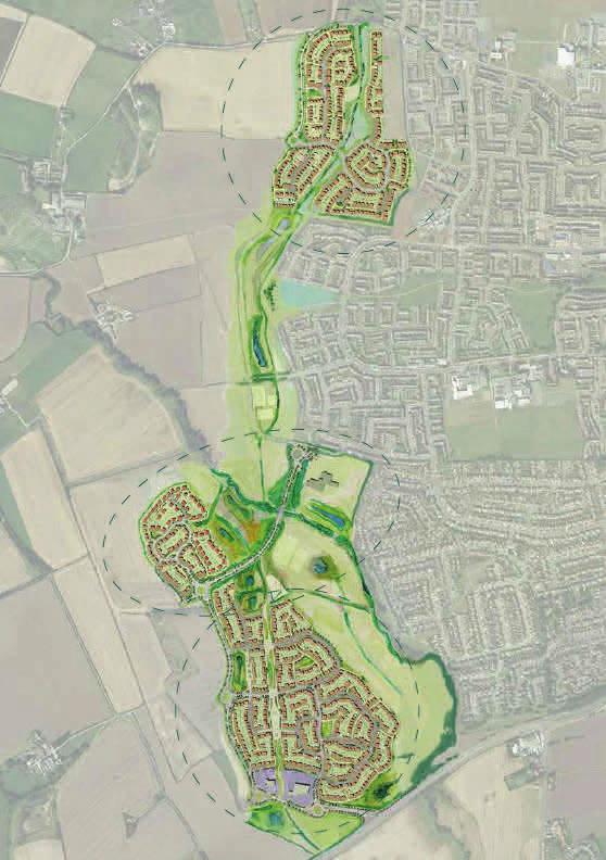
5 Indicative Masterplan 5

6 Site Description The site is located within the Borough of Hartlepool, at the south western edge of the Hartlepool urban area ranging from approximately 1.65km to 2.65km of the town centre. The site is located beyond the development limits of Hartlepool and is currently within the open countryside. The A689 Stockton Road runs to the south of the site and provides direct access to the A19 located approximately two and a half miles to the west of the site. hectares) is centred around the beck running the length of the western edge of the Fens Estate. Existing vehicle access into the site is currently limited given its agricultural use; however there are tracks within the site facilitating access to the fields and the existing farmsteads. The southern site area contains two farms, accessed from the A689 Stockton Road, Claxton Farm and Lower Claxton Farm. A designated footpath runs alongside Greatham Beck linking from Greatham village, through the site, to Owton Grange and Brierton. A further footpath runs from a point on Stockton Road to the east of the site, linking the two southern farms (Claxton Farm and Lower Claxton Farm) to Dalton Back Lane. There is an informal track access across the fields to Brierton Village and the quarry from the urban area, and a public byway along Macrae Road through to Owton Farm and Brierton Lane. Macrea Road also currently provides access from the site into the existing neighbouring residential area. The site is approximately hectares (gross) in size and currently comprises arable agricultural land of predominantly Grade 3b and small areas of Grade 4 soil grade. The boundaries are primarily marked by hedgerows. The site is defined by the A689 Stockton Road to the south, Dalton Back Lane to the west, Brierton Lane to the north and the existing settlement to the east. The site s western boundary is onto open countryside with the next significant settlement being Sedgefield that lies a number of miles to the west. The existing residential areas of Owton Manor and The Fens are located to the eastern boundary of the site. Beyond the A689 Stockton Road to the south of the site are agricultural fields and the village of Greatham further to the south east. The site includes Greatham Beck, which runs diagonally through the site. This is classed as a main river by the Environment Agency. A small Local Wildlife Site (LWS) (0.55 At the north eastern corner of the site, on Brierton Lane, lies the southern entrance into the 100 acre Summerhill Country Park, transformed from low-grade farmland into a Local Nature Reserve that is also an outdoor sports centre. Approximately 65,000 trees were planted in the late 1990s and are now maturing into woodland, with ponds and grassland meadows. A 200mm gas main runs underground through the site from north to south, with a 100mm gas main spur running underground in an easterly direction to Macrae Road. Water mains also cross the site underground, one runs diagonally across the site close to the beck and the other crosses the centre of the site east to west close to the line of the existing Public Byway. A number of overhead power lines also cross the site to the south of the beck (66kV) and to the southern part of the site closest to the A689 Stockton Road (11kV). A culverted watercourse exists to the north east of the site which is under the jurisdiction of Hartlepool Borough Council. 6

7 Development Description The planning application is a hybrid with part of the proposals for the site applied for in full and part in outline. For the outline elements, all details relating to appearance, layout, scale and landscaping are reserved for consideration at a later date. The descrip on of development for the hybrid planning applica on is as follows: Matters of Detail: The detailed application comprises the demolition of buildings, earthworks across the site to create development platforms, creation of drainage features across the site*, the construction of 144 dwellings (C3), construction of access to Stockton Road and Brierton Lane, the northern and southern access road and vehicular bridge with associated structures over the beck** and vehicular circulation, public open space*, landscaping*, ecological works* and associated infrastructure. Matters in outline: The outline application comprises the construction of up to 1,116 dwellings (C3), public house/restaurant (A3/A4 retail, 500sqm), retail (A1 retail, 2,499sqm), primary school (D1), medical centre (300m2), public open space, playing fields, play spaces, drainage features, landscaping and ecological works, noise mitigation, electrical sub stations, pumping stations, car parking and vehicle and pedestrian circulation. *level of detail confined to that shown on the plans identifying the location and volume of the SUDs, electrical sub stations, pumping stations, sports pitches and to the landscaping within the Green Wedge, with the precise details to be secured through the application of suitable planning conditions. ** As shown on the submitted plans. Location Plan 7
8 Phasing The anticipated start date for enabling works is the second quarter of First occupation of dwellings would be within the third quarter The site is anticipated to be developed out by a number of house builders at an approximate average annual rate of 30 dwellings in the last quarter of 2015, ramping up to 175 dwellings per annum in later years. This results in a total build of eight to nine years and therefore an anticipated completion year of This is identified in the table below: Year Annual Build Out Total remaining development working from these access points into the site concurrently at the rate of development identified in the table above. The development of the northern and southern access roads will be developed as housing is brought forward from either end of the site. Construction access will also be from each of these access points (the A689 Stockton Road and Brierton Lane) to serve either end of the site. The delivery of the local centre is largely market dependent and an assumed timing of delivery is as an early phase of development as the southern development area is developed. The delivery of the primary school will be dependent on capacity in existing local schools and the build out rate of the proposed development which is directly related to the number of children generated by the site. The anticipated delivery of the primary school is therefore by The drainage features will be developed as required to serve the development as it comes for so they are in place at the appropriate time. In terms of the site s development, the detailed element of the hybrid planning application will be implemented initially along with the access points at either end of the site, with the Landscape buffers and the Green Wedge will be developed as the scheme develops, however there will be early delivery of elements of these in order to mitigate the impacts of the proposals and to ensure planting can become established in order to fully perform its purpose. 8

9 Planning Policy Context Planning Policy supports schemes that will assist in regeneration and encourage growth and investment into Hartlepool. Section 38 of the Planning and Compulsory Purchase Act 2004, states that applications should be determined in accordance with the development plan unless material considerations indicate otherwise. Consideration will also be necessary to the appropriate weight to be afforded to the development plan following the publication of the National Planning Policy Framework ( The Framework ). The Framework indicates that the policies within it have material weight from the day of its publication. This is also considered in the context of the National Planning Policy Guidance (hereafter referred to as PPG ). The Statutory Development Plan for consideration of this application comprises the: Hartlepool Local Plan (Saved Policies), November 2006 Tees Valley Joint Minerals and Waste Core Strategy Development Plan Document, September 2011 Tees Valley Joint Minerals and Waste Policies and Sites Development Plan Document, September 2011 Planning (Transitional Arrangements) (England) Regulations 2004 and not the Town and Country Planning (Regional Planning) (England) Regulations Under the Planning and Compulsory Purchase Act 2004, unless expressly replaced by a `new` policy, `old` policies of an adopted Local Plan were automatically saved for three years from the date the Local Plan was adopted. On 13th April 2009 the Council saved the vast majority of the policies included in the 2006 Local Plan as they were considered by the Council to be relevant and did not repeat national planning guidance at the time. The saved policies of the 2006 Local Plan were subsequently used as a basis alongside national planning policy to determine planning applications. The withdrawal of the 2013 Local Plan (see below) placed the Council in a situation where the planning policy framework consists of saved 2006 Local Plan policies which are consistent with national policy, the guidance contained in the National Planning Policy Framework and other material considerations. The document: Saved Policies 2006 Hartlepool Local Plan: Planning Policy Framework Justification (May 2014) summarises and provides an opinion on the 2006 Local Plan saved policies and their consistency with The Framework. Of the 136 saved policies in the 2006 Local Plan the majority of the policies were assessed to be in full or partial consistent with The Framework with only 13 found to not be consistent with The Framework. The borough has specific policy areas where the 2006 Local Plan Saved Policies is silent and/or the relevant policies are out-of-date and The Framework delegates the decision making to the development plan. The policy areas are below: The 2006 Local Plan identified strategic land allocations to meet the demand and needs for new and existing housing, employment, retail, leisure and sought to guide and control development in the borough up to The 2006 Local Plan was prepared in accordance with the Town and Country Demonstrating a 5 Year Supply of Deliverable Housing Site Affordable Housing Renewable Energy 9
. The Local Plan (2006) identified a gross requirement for 2002-2016 of 6,095 dwellings, which equates to approximately 435 dwellings per annum.")
10 The Need There is a significant pressing need for housing to be delivered in Hartlepool and this was confirmed through the evidence based documents supporting the now withdrawn emerging Hartlepool Local Plan (2013). The Local Plan (2006) identified a gross requirement for of 6,095 dwellings, which equates to approximately 435 dwellings per annum. The Regional Strategy for the North East identified a net requirement for 390 units per annum in Hartlepool. However, the Local Plan (2006) is out-of-date and the RS revoked. None of the previous housing policies that restricted housing numbers form part of the saved policies of the Local Plan (2006). Through the now withdrawn Hartlepool Local Plan (2013), the Council identified a need for 4,800 new dwellings (net) to be built during the plan period, meaning an annual net housing requirement of 320 dwellings. The now withdrawn Local Plan was considered through due process, although not adopted. The Council cannot demonstrate a five year supply of deliverable housing sites to meet the housing requirement over the next 5,10 or 15 years when considering the projected gross housing requirement and the projected demolitions in the borough. As the Local Plan was withdrawn in 2013, before its adoption, the supply counted within the five year supply calculation, does not include any of the emerging site allocations, such as the Hartlepool South West Extension. The Council has identified a 4.6 year supply of housing, however this does not take account of the undersupply of housing over previous years. Through work undertaken to support this planning application, it is believed, that the land supply position is closer to a 3.3 year supply (informed by the need to address the undersupply during the last 5 years ). In any case, there is shown to be a significant need for housing delivery in Hartlepool to meet the needs of the Borough now and in the future. All policy documents and policies (saved, withdrawn and revoked) identify the town of Hartlepool as the focus for this growth, being the main town within the Borough. There are however limited opportunities for this growth to be provided in a sustainable location, given the nature of the town and its geographical location with the coast to the east of the settlement. In addition to the known housing need, the Borough has also persistently under delivered housing, and as such paragraph 47 of the National Planning Policy Framework (March 2012) (The Framework) is relevant, which requires an increased housing provision of 20% over the first five years. The Council, using an evidence base document for the now withdrawn Hartlepool Local Plan (2013) ( Future Housing Provision in the Borough for the Next 15 Years (April 2013)), calculate this as requiring 384 dwellings per annum for the first five years, falling to 288 dwellings per annum beyond this. This is supported by the more recent May 2014 Framework that the Council has produced. The development of the Hartlepool South Western Extension site would provide a unique opportunity to meet a significant element of this need over a number of years and into the future. It will also provide a comprehensive development, in a sustainable location with a strength of opportunity to provide significant benefits such as affordable housing, education inward investment and a mix and choice of housing provision in the area. The need for the application site to come forward for housing was fully considered through the now withdrawn Local Plan (2013), which whilst not adopted, went through due process by way of an examination by an Inspector. 10
11 The Need Continued... Through this process it was identified as the only strategic housing allocation, and therefore a key element of the housing delivery to meet Hartlepool s housing needs. The Inspector had indicated that subject to certain modifications, the plan could have been made sound. Modifications included confirmation of the delivery of 2,200 dwellings at the Hartlepool South West Extension within the 15 year plan period. The Framework (March 2012) provides an extremely strong emphasis on sustainable development and growth with a clear presumption in favour of sustainable development. The Framework supports sustainable development and the Ministerial foreword to this document confirms this is about positive growth making economic, environmental and social progress for this and future generations. Paragraph 14 of the NPPF identifies that the presumption in favour of sustainable development is at the heart of the Framework, and that this should be seen as the golden thread running through both plan-making and decision-taking. In respect of decision taking, and where the development plan is absent, silent or relevant policies are out of date (as in the case of Hartlepool), planning permission is to be granted, unless any adverse impacts of doing so would significantly and demonstrably outweigh the benefits, when assessed against the policies in this Framework taken as a whole, or specific policies in the Framework indicate development should be restricted. The need for the application site to come forward for housing is also supported by its highly sustainable location. It is located on the very edge of the urban area immediately adjacent to key routes into the town (A689 and Brierton Lane). The masterplan indicates that there are numerous opportunities to provide both formal and informal linkages with the adjacent urban area. The site is located close to a range of services and amenities and within close walking distance of key bus routes linking to the main Town Centre to the north-east. The A689 forms the key routeway into the town from the south. The site located in a sustainable location and on a key link to significant services and facilities. The town has a range of large supermarkets and other shops, as well as a number of major leisure opportunities. There is also easy linkage to other main settlements in the sub-region (and beyond). The adjacent urban area has schools, shops and community facilities that will be in easy walking distance from the site, particularly once new networks of footpaths, bus route(s) and other connectivity area established. The surrounding area is sustainable and whilst the site will also provide additional services and facilities, these are designed to create a sense of place and to enhance/complement the existing provision. The Hartlepool South West Extension is site is available, suitable and achievable for development and it is therefore deliverable and developable in order to help meet the housing need for Hartlepool. In terms of the other development proposed, the retail provision is needed to support the proposed housing and to create a sustainable community. This will enhance sustainability through creating walkable neighbourhoods and reducing the need to travel. The creation of a centre also contributes to the creation of place. There is therefore considered to be a need for the level of retail proposed as part of the overall development of the site given the level of residential development proposed. The primary school, medical centre and public house proposed as part of the application are all uses that are identified within the scheme to make it more sustainable as well as to relieve pressure on existing services in the vicinity of the site and are designed to serve the new population created. There is therefore also considered to be a need for these as part of the overall development of the site given the level of residential development proposed. In summary, there is considered to be a clear need for both the level of development proposed and the development of the application site. 11
12 Consideration of Alternatives There is a significant need for development and growth in Hartlepool to provide the houses and jobs needed as well as to secure the much needed growth, regeneration and inward investment. The application site is part of a wider site that is being promoted for development through the emerging Local Plan and the previously withdrawn emerging Local Development Framework (2013). As the site was allocated within the now withdrawn emerging Local Plan (2013), it was considered comparatively with other sites and was chosen as the most sustainable of available options to meet the identified needs in the Borough. This site was specifically confirmed as a key and strategic site for the delivery of Hartlepool s housing needs in a very sustainable location. The environmental merits of this have been considered in detail through the evolution of the now withdrawn Local Plan (2013), both by the applicant s consultant team and the Local Authority in their consideration of sites for allocation and subsequently the Inspector through the examination process. Given this need and the sustainable location of this site, no other forms of development have been fully considered for the site, and therefore alternative development options largely concentrate on the quantum of development and how environmental considerations have influenced the design evolution of the proposed residential development. Do Nothing To do nothing with the site would mean the site is retained as existing and therefore as agricultural fields. This would mean that the housing needs in Hartlepool would not be met through the development of the most sustainable sites. The effect of this would be to sterilize the redevelopment of sustainably located sites. This would therefore not allow the significant need for new housing to be met, which would be contrary to local and national planning policy. Whilst the retention of the site as agricultural fields may have some environmental benefits, the land is not the best or most versatile agricultural land as it is grade 3 and 4 agricultural land. Without the sites development, there are a number of environmental improvements that would not be secured. These include the socio economic, inward investment and regeneration benefits of the proposals, which are much needed in the area. Furthermore, the ability to secure long term management of the area alongside the Greatham Beck which will secure benefits for the beck itself, provision of managed green infrastructure within the site and the enhancement of ecological habitats would be lost as would a managed drainage strategy for the site with at least a 30% betterment of existing greenfield run off rates compared to existing, uncontrolled circumstances. The alternative to the redevelopment of the application site would mean that development would have to be provided elsewhere. Given the significant sustainability of the site, with its location immediately to the west of the urban area of Hartlepool, development elsewhere would ultimately be in a less sustainable location and would put pressure on further development in the countryside or more rural locations. This is further emphasised by the lack of other suitable sites and the restriction created by Hartlepool s location adjacent the coast to enable development to the east. Development in less sustainable locations would lead to increased impacts on the environment, especially from those associated with traffic, noise and air quality with the development of less sustainable sites and potentially greater impacts on ecology and the landscape along with potentially greater visual impacts. The Do Nothing scenario would therefore not allow the significant need for new housing to be met, which would be contrary to The Framework. 12
13 Consideration of Alternatives Continued... Compliance with the Development Plan The Local Plan (2006) was prepared in order to replace the then existing 1994 Local Plan, subsequently a number of its policies have been saved to be used as a basis for determining planning applications alongside national planning policy and guidance. The site is identified as Tees Forest within the Local Plan (2006), which seeks to contribute towards sustainable development and improve the physical environmental of the countryside area. The site is also identified as being adjacent to, but beyond the Urban Fence and Limits of Development of the main urban area of Harltepool, however, the Council confirms that whilst this is designed to contribute towards sustainable development and control development beyond the urban fence, this is not in accordance with The Framework in respect of housing development, which is specifically excluded from this policy. The Council has acknowledged that it does not have an up-to -date Local Plan and a number of their saved Policies in the 2006 Local Plan are not in conformity with National Policy. The Council cannot identify a five year supply of deliverable housing sites and so the weight that may be ascribed to the Local Plan is significantly reduced and material considerations, in particular The Framework (and PPG) is afforded greater weight, and in particular the presumption in favour of sustainable development applies. Development of the South West Extension clearly constitutes a significant change from an area of greenfield land in agricultural use to one of strategic scale residential-led development. The land is currently in open countryside beyond (but on the immediate edge of) the existing Urban Fence. There will be harm in terms of loss of agricultural land and potential for increased pressure on existing services and facilities. However this is weighed heavily in the balance of the benefits that the site will create in terms of meeting a significant proportion of the identified housing needs for the borough as well as providing new built and green infrastructure that will benefit the Town. The proposals conflict with the current Local Plan designation of open countryside, but the Council confirm that the relevant Policies (RUR1 and RUR12) relating to the Urban Fence and housing in the open countryside, no longer accord with National Policy as the Council s stated housing supply permission means that the development needs of the borough cannot be met without reconsidering boundaries for the Urban Fence and considering sites that may currently sit in open countryside. The South West Extension is the next logical strategic scale development area, following the pattern of development established in previous decades. Smaller piecemeal approaches to housing development will not meet the Council s significant requirements. This was established through due process in the withdrawn Local Plan (2013) where the application site effectively underpinned delivery of the Plan as by far the most significant allocation. As such, the proposals would have been in compliance with the now withdrawn Local Plan (2013) had it been adopted following the implementation of modifications identified by the Inspector after the Examination in Public. 13
14 Design Evolution The preferred option is for the site s development with 1,260 residential units with retail, public house/restaurant, medical centre, primary school and associated infrastructure and ecological, landscape and drainage mitigation. There have been a number of iterations to the scheme to reach the proposed development, which have been influenced by the quantum of development and environmental and design considerations. Initial site promotion for the allocation of the site for a strategic housing allocation in the emerging Local Plan began in 2009/2010 by Yuill Homes (Cecil M Yuill Ltd). The Advocacy Document produced in March 2010 analysed the site s deliverability and benefits. The indicative masterplan identified an area for development greater in extent than the planning application. It proposed in excess of 2,750 dwellings at a density of approximately 30 dwellings per hectare with neighbourhood hub including provision of education, health, retail, green wedge and a strategic landscape framework. This responded to the emerging Local Policy Preferred Options in January 2010 and influenced subsequent emerging Local Policy which saw iterations to their emerging Local Plan from the Core Strategy Preferred Options in November 2010 through to the Publication Core Strategy and Submission Local Plan in February 2012 and June 2012 respectively. Iterations mainly related to the extent of Green Wedge and developable areas. The scheme evolved further through the EiP in January 2013 to include more detail about how the site could be developed, taking account of constraints and environmental issues. The scheme submitted for EIA Scoping in February 2014 identified a refined scheme which had evolved to take account of further assessment, liaison with key consultees, the community and HBC and further design work. The proposals included 2,650 dwellings, public house/restaurant (500sq m), retail (2,499sq m A1), primary school, medical centre (300sq m), a petrol filing station, access to Stockton Road and Brierton Lane linked by a spine road through the entire site, public open space, playing fields, play spaces, drainage features, landscaping and ecological works, noise mitigation, substations, pumping stations, car parking and vehicular and pedestrian access. Following receipt of the Scoping Opinion from HBC in April 2014, further assessment work and ongoing discussions with key consultees, in particular the Highways Agency and HBC Highways, the scheme evolved to reduce the quantum of development to 1,260 dwellings in order to address concerns with the highway capacity, mainly at the A1 junction with the A689. This is with a view to resolving the issues to allow a future application to come forward for the remaining development once a solution is found to address the highway capacity issues. This also lead to a reduction in the application site boundary and lead to the creation of two distinct development areas, one accessed from Brierton Lane to the north and Stockton Road to the south. There is no longer the need for a link road through the site, so each area of development is now to be served from its respective north and south access points. This ensures the traffic generation from the site is managed within highway capacity whilst talking account of the proposed off-site highway works proposed as part of the application proposals. These proposals also now negated the need for an eastern access to Macrae Road which was a concern for Local Members and community. The proposals do not however preclude the link road or access to the east from becoming part of future development of the site, which would be the subject of further environmental assessment as part of a separate planning application in the future. 14

15 Design Evolution Continued... Parameters Plan 15
16 Noise A Noise Assessment associated with the proposed development has been undertaken which is provided as a supporting report to the Hybrid application. In summary a noise survey was undertaken on site to establish existing background noise levels with the main sources of noise pollution identified as Stockton Road (A689) adjacent to the southern boundary of the site and an existing quad bike facility to the north west of the site. The assessment also identified potential noise impact from the proposed on-site access roads which serve the northern and southern development areas as well as potential noise impact on existing and proposed adjacent residential properties from the proposed primary school. Noise Impact from Stockton Road (A689) It is proposed that the development will incorporate mitigation to protect the new residential dwellings in the southern part of the site that are within 175m from Stockton Road (A689) by way orientating the proposed units to face towards Stockton Road (A689) so that the residential units themselves screen the amenity gardens and the 55dB(A) or less criterion will be met. The proposed development at the south eastern extremity of the site increases in distance from Stockton Road (A689) which once the distance exceeds 175 metres there will be sufficient attenuation of noise by distance that it will not be necessary to orientate residential units to screen the associated amenity gardens. Based on the orientation of the proposed residential units on the southern boundary front facing towards Stockton Road (A689) supplementary measures (enhanced glazing, ceiling construction and sound attenuated ventilators) will be necessary with a reasonable design target to limit Daytime Internal Noise Levels to 35dB(A) and Night Time Internal Noise Levels to 30dB(A). This would generally be considered to be representative of a good internal noise environment. Furthermore it is considered that all other proposed residential units that will be screened by the proposed units on the southern boundary will not require mitigation to protect against noise from Stockton Road (A689) subject to detailed design. Noise Impact from the Existing Quad Bike Facility Based on the closest proposed residential units being located at a minimum distance of 650 metres away from the existing quad bike facility the resultant noise level is 35dB(A) and (noting that it will be further reduced by screening, ground attenuation or further distance) is extremely unlikely to give rise to any noise related complaint and as such no mitigation is required. Noise Impact from the proposed on site northern and southern access roads Based on residential units being within 10m of the on site northern and southern access roads there will be mitigation requirements by way of orientating units to front face the access roads in which to protect rear amenity gardens. However, where proposed residential units are within 10m of the on site northern and southern access roads and are orientated with amentity gardens having views of the proposed access roads then screen fencing or walls to an effective height of 2.0m will be required to achieve the following: Northern Access Road Reduction from 59dB(A) to less than 55db(A) Southern Access Road Reduction from 61dB(A) to less than 55dB(A) However, noise levels are not likely to be severe and all relevant guidance levels and criteria can be easily met with no additional mitigation to that of enhanced glazing, ceiling construction and sound attenuated ventilators in which to achieve a reasonable design target to limit Daytime Internal Noise Levels to 35dB(A) and Night Time Internal Noise Levels to 30dB(A). This would generally be considered to be representative of a good internal noise environment. Noise Impact from the Proposed Primary School The proposed primary school at detailed design stage will ensure that noise pollution from external playgrounds is suitably screened to ensure minimal likelihood of noise related complaints from existing or proposed receptors (residential properties). The required screening will be created by protection from the proposed school building through orientation and/or building footprint or by screen fencing or wall. 16
17 Socio - Economic The proposed residential development brings a series of significant benefits to the Manor House, Fens & Rossmere and Rural West wards, Hartlepool and the Tees Valley. The overall impact of the proposal in terms of socio-economic issues is considered to be negligible to minor / moderate beneficial due to the delivery of new homes some of which will be affordable, self-build and senior living housing, a local centre comprising of a two form primary school, a medical centre and retail and leisure uses, which confirms the positive effects that the development will have to the local community and economy. The provision of new housing within the Manor House, Fens & Rossmere and Rural West wards could have a moderate beneficial impact upon the current migration rates and expected levels of population growth as more homes will be made available to the local population. The delivery of a range of housetypes including self-build and senior living homes will be provided on the site to respond to the existing housing market need within the area which again provides a positive impact on the need for housing within the area. Delivery of affordable housing if viable will assist in addressing the need within the area. The proposed residential scheme will provide a range of employment opportunities for the local population. The Technical Paper indicates that the scheme will deliver 1,890 temporary direct jobs (construction of housing only) and a range of spin off jobs whilst 2,890 extra jobs could be created in the wider economy for the houses constructed (assuming 1,260 units are delivered). The employment opportunities the development could bring are significant and provide moderate benefits. The proposed commercial area and community infrastructure could provide 289 new jobs within the area. There will be additional demand for local services which would have a potential positive impact on the employment of additional staff by existing businesses in the locality. The proposed project could generate 30,281,580 of net additional Gross Value Added within Harltepool per annum. This relates to construction jobs which will be for a finite period. The development of the site opens the local area and presents its assets to the wider area which could in turn benefit the local economy The total household expenditure the scheme can achieve is 26.7 million, however this would not be additional expenditure as some people would not be completely new households. The proposed development could provide the Local Authority with 9,286,741 (30% affordable homes) 8,492,941 (0% affordable homes) over 6 years as part of the New Homes Bonus which could assist in delivering housing growth within Hartlepool. The scheme has the potential to generate 1.6 million in additional Council Tax payments to Hartlepool Borough Council. The creation of a series of new footpaths and cycleways and the provision of new areas of public open space for use by both the existing community and new residents to the site will encourage activity, walking and cycling. The redevelopment of the site for 1,260 new homes within Hartlepool will inevitably impact upon community infrastructure within the locality in particularly in terms of the of available health and education services. The delivery of a two form entry primary school and a medical centre within the local centre will help to address capacity issues within the local area. 17
18 Ecology and Nature Conservation Section 6 of this Environmental Statement looks at the potential impacts arising from the development upon features of ecological and nature conservation interest. A thorough desk based assessment has been completed, collating data from the local environmental records center, statutory consultees, conservation groups and local residents. A comprehensive scoping and consultation process has also been completed. Included within this consultation process were the local planning authority s ecology officer, Natural England, the Environment Agency and various local conservation and residents groups. Ecological survey of the site has found that the current development boundary supports a number of habitats that are of ecological value. These include broad-leaved seminatural woodland, standing and running water and semiimproved grassland. The habitats present have been valued from Site to Local significance. The Site has also been identified as having habitats suitable to support a number of protected species including bats, great crested newts, potential water vole, and nesting birds. Breeding bird survey found that the site supported a total of 41 breeding species. Wintering bird survey recorded several notable species including shelduck, and lapwing. Survey for bats, great crested newt, otter, water vole and badger were completed. No notable populations of protected species were recorded, although a small population of great crested newt was recorded in a pond offsite to the west. A modest assemblage of bats also utilise the site, including a small population within Claxton Farm. A number of potentially damaging impacts have been highlighted as part of the assessment process. Key impacts considered included potential impacts upon sites of international and national conservation importance, impacts upon the Greatham Beck Local Wildlife Site (which runs through the center of the site), impacts upon breeding birds, loss of habitat and impacts upon protected species. These impacts have all been assessed and it is considered that through a combination of development phasing, carefully targeted ecological mitigation measures, landscaping, habitat creation and GI provision all potential negative impacts arising from the development can be effectively managed. This will ensure that no significant long term impacts will occur as a result of the proposed development. In many cases it is considered likely that beneficial effects will occur. In summary it is considered that following development, the area within the development boundary will benefit from a net increase of biodiversity provision. Providing a mosaic of wellconnected habitats of greater value than are currently present, benefitting both the species resident within the site and those in the wider area. Ecology and Nature Conservation Receptor Plan 18

19 Cultural Heritage Research into the archaeology and history of the proposed development area has taken place. This involved the examination of pertinent historic mapping and other secondary sources, including the Historic Environment Record, a record of all known historic sites in the area. This concluded that there was a possibility of parts of the site having been occupied in the prehistoric and Romano-British periods. There were no indications of a mediaeval settlement being present, other than a medieval post-mill slightly beyond the north-east boundary of the site. Two post-medieval farms were noted, one of which has standing buildings of 19th century origin. Next to this is a small area of upstanding ridge and furrow. A geophysical survey was conducted across much of the area, which identified a possible later prehistoric / Romano-British enclosure, together with some other features which may also be archaeological in origin. No archaeological or cultural heritage resource has been identified which needs to be preserved. Whilst the impact of the development on the resources will be negative, a series of mitigation measures have been put forward, comprising archaeological recording, which will limit the extent of this impact. Cultural Heritage Receptor Plan and Proposed Further Archaeological Works 19

20 Air Quality An Air Quality Assessment has been undertaken for the proposed development in accordance with Planning Practice Guidance produced in March 2014 to support The National Planning Policy Framework, guidance provided by Environmental Protection UK and the Institute of Air Quality Management. The scope of the assessment has included existing and proposed receptors along with any sensitive ecological locations. Air pollution associated with additional road traffic generated by the development is the main long term consideration with impact from dust associated with construction and demolition also being a short term consideration. Due to the current absence of air quality issues, the low background concentrations predicted for the area and the imperceptible or small adverse changes in pollutant concentrations associated with the additional road traffic flows, the overall impact of the development is predicted to have a negligible effect on the local air quality. This applies to receptors local to the development and within the wider borough. New receptors within the development will be exposed to concentrations of air pollutants well below the air quality standards. A significant buffer zone has been allowed between the A689 and the nearest properties to further minimise exposure to road traffic pollution. Although there is a low risk of dust nuisance associated with the southern phase of the development, there is potential for existing receptors close to the northern development area to be affected by nuisance dust associated with earthworks, construction and trackout. However, with the inclusion of appropriate mitigation measures, the impact of these activities will be controlled to a satisfactory level. The extraction system from the kitchen of the proposed public house/restaurant will be designed in accordance with DEFRA guidance to prevent odour nuisance. The waste water pumping station will also be designed to appropriate standards to prevent odourous releases and remove the potential for odour nuisance. There are no intensive farming activities surrounding the development site and adequate buffer zones have been preserved around the perimeter to prevent odour nuisance from general agricultural activities and livestock sheds. The findings of the Air Quality Assessment has indicated that the site can be developed with no risk of future residents being exposed to adverse air quality and negligible effects at existing receptors. Therefore development of the subject site is considered appropriate on the scale proposed. Air Quality Indicative Extent of Potential Receptors 20
21 Soils and Geology, Hydrogeology and Hydrology Made Ground A review of the 1:10,000 scale BGS geological plans indicates a small area of made ground shown within the northern site boundary immediately off Brierton Lane which may have been a former clay borrow pit or an infilled depression. An area of infilled ground is also noted off-site to the northern boundary of the site, also believed to be associated with small scale sand and gravel extraction off-site. Organic deposits (alluvium) and other deposits of potential Made Ground (including inert, household, commercial and industrial construction waste such as slate clay and brick) are locally anticipated. Organic alluvium is likely to be restricted to the low lying ground adjacent the Greatham Beck. Made Ground associated within the site (farms and tracks) is anticipated which have the potential to contain asbestos containing materials (ACMs). Superficial Soils Undifferentiated glaciolacustrine deposits, typically comprising normally consolidated silt and clay with horizons of sand and occasional gravel are recorded occupying the majority of the southern half of the site. River Terrace Deposits occupy the eastern boundary, extending down from the north to the broader sections of the central and southern area of the site and around the flanks of Greatham Beck. These deposits comprise sand and gravel and silt. Overlying these deposits mainly along the fringes of the Greatham Beck in the southern and central areas, alluvium (poorly consolidated gravel, sand, silt and clay locally including organic clay and peat) is recorded. Localised deposits of alluvium are also indicated along the northeastern boundary, down to the central area joining the Greatham Beck. A localised area of Head deposits (gravel, sand and silt) are noted to be present in the far south of the site, immediately south of Lower Claxton Farm at the point where the Greatham Beck leaves the site. Glacial till (locally referred to as Boulder Clay ) is present at the ground surface across the majority of the northern half of the site and present within the southern half of the site beneath the overlying surface soils described above. These soils generally comprise predominantly medium and high strength clay with variable subdominant quantities of silt, sand, gravel, cobbles and boulders. Such deposits are likely to extend down to rockhead. The full drift thickness was proven in two BGS boreholes confirming drift depths of 26m (to the northwest) and 17.37m (to the southeast) over bedrock comprising a variable sequence of sandy clay, sand and gravel. Similar drift soils were proven in the southwest, confirming a variable sequence of silty clay, sandy silt and sandy gravel (Glaciofluvial Deposits) to 25.00m bgl. BGS borehole in the east confirmed the presence of laminated clay (Glaciolacustrine Deposits) from surface to at least 18.00m bgl. Bedrock Bedrock comprises of sandstone of the Sherwood Sandstone Group beneath the entire site. This unit comprises fine grained thickly bedded red sandstones with subsidiary grey sandstones, red mudstones and siltstones. A BGS borehole, located in Brierton Quarry approximately 500m east of the site, proved this sequence of sandstone with subordinate, siltstone and mudstone to a full depth of 96m bgl. 21


22 Flood Risk Flood Risk A Flood Risk Assessment has been undertaken for the proposed development in accordance with the Technical Guidance to The Framework, and is provided as a supporting report to the Hybrid application. In summary the overall development site falls within Flood Zone 1, 2 and 3a in accordance with the Environment Agency flood maps associated with the Greatham Beck which crosses the central part of the site from west to south east. Furthermore the proposed mixed use development will be wholly within the Flood Zone 1 area which is an area at low risk of flooding with an annual probability of flooding of <1 in 1000 (<0.1%) from river or sea flooding. The southern area of the mixed use development is served by a proposed main access road off Stockton Road (A689) which crosses the Greatham Beck and Flood Zone 2 and 3a areas via a proposed road bridge. The bridge structure supporting the main access road serving the southern area of the development will be designed with the full supporting structure within the Flood Zone 1 area. Furthermore the proposed level of the underside of the bridge supporting deck will be above the 1 in 1000 year flood level plus climate with a minimum of 600mm freeboard provided. The proposed development will also incorporate additional flood shelving areas on the western side of the Greatham Beck in the southern part of the site providing additional flood areas to accommodate flood waters which will improve existing flood risk on the site and reduce the flood risk impact on adjacent third party land and properties. The findings of the Flood Risk Assessment report has identified that the subject site can be developed with no increased risk of flooding to the proposed development or to third party land with improvement and betterment provided as part of the proposed scheme, therefore development of the subject site is considered appropriate. Flood Risk & Drainage Indicative Extent of Potential Receptors 22
23 Flood Risk Continued... Proposed Drainage Strategy The response to a NWL Pre Development Enquiry indicated that proposed surface water flows from the development should discharge to the Greatham Beck with proposed foul water flows discharging to existing public combined and foul water sewers to the east of the development. Proposed Surface Water Drainage It is proposed that the surface water drainage design associated with the mixed use development will consist of discharging the proposed surface water run-off into the existing Greatham Beck within the site boundary at a restricted rate equivalent to the existing Greenfield run-off rate for a 1 in 100 year storm event, plus a minimum betterment of 30% in accordance with the Environment Agency requirements. The proposed drainage strategy is based on discharging proposed surface water at restricted rates via 6No discharge points into the Greatham Beck. This will split the development areas to allow variation in the rates of discharge, points of discharge and timing of each individual discharge in which to replicate the current Greenfield run-off mechanism as advised by the Environment Agency. The proposed surface water drainage for the development will be designed to achieve the restricted discharges via the use of hydro-brakes, orifices and other similar flow control devices with on-site attenuation provided through a combination of swales and attenuation basins to accommodate up to a 1 in 100 year storm return period plus an allowance for climate change in accordance with Environment Agency and the Local Authority SUDS Approving Body (SAB) requirements. The principles of the proposed surface water drainage strategy have been agreed with the Environment Agency and the Local Authority SUDS Approving Body (SAB) subject to detailed design. It is proposed that on site surface water piped sewer systems will be adopted and maintained by NWL under a Section 104 Agreement with proposed on site attenuation basins and swale networks adopted and maintained by the Local Authority. Proposed Foul Water Drainage It is proposed that foul water flows from the northern area of the development will discharge via a combination of gravity foul water sewers and an on-site pumping station and rising main to an existing public 375mm diameter combined sewer at existing manhole MH8801 in Wynyard Road to the north east of the development in accordance with NWL requirements. Furthermore proposed foul water flows from the southern area of the development will discharge via a combination of gravity foul water sewers and 3No. on-site pumping stations and associated rising mains with flows discharging to an existing public 375mm diameter foul water sewer to the south east of the development on the northern side of Stockton Road (A689) at existing manhole MH6603 in accordance with NWL requirements. The design and location of the proposed on site foul water pumping stations will be in accordance with current Sewers for Adoption with pumping stations no closer than 15m to habitable buildings in order to minimise the risk of odour, noise and nuisance. It should be noted that all proposed on site and offsite sewer infrastructure including foul water pumping stations and associated rising mains will be adopted and maintained by NWL under a Section 104 Agreement. 23
24 Utilities Utilities Assessment associated with the proposed development has been undertaken which is provided as a supporting report to the Hybrid application. In summary the existing record plans received from the various utility providers detail the following apparatus crossing the Site: A twin overhead high voltage 66kV cables crossing the southern part of the Site, extending from the south-east corner of the site in a north-westerly direction a single overhead high voltage 11kV cable run crossing the southern part of the site a 200mm-diameter regional high pressure gas main bisecting the Site running north to south a 100mm-diameter regional high pressure gas main crossing the centre of the Site two potable trunk water mains, 30 -diameter and 700mm-diameter, crossing the southern part of the Site a 8 -diameter trunk water main crossing the centre of the Site a 25mm-diameter water distribution main extending east-west across the southern part of the Site underground and overhead telecommunication cables crossing the southern part of the Site extending from Stockton Road (A689) on the southern boundary underground telecommunication cables in the highway verge of Brierton Lane and Stockton Road (A689) immediately north and south of the Site respectively. There is also further electric, water, gas and telecommunications apparatus located off site but in close proximity to the Site within the residential development to the east, in Stockton Road to the south and within the open agricultural land to the west. The proposed development allows for the existing twin overhead high voltage 66kV cables, the regional high pressure gas mains and the 30 -diameter, 700mm-diameter and 8 - diameter potable trunk water mains to remain in their current location within easements/wayleaves. Diversions will be required on the existing high voltage 11kV cables in the south, the existing 30 -diameter and 700mmdiameter trunk water mains adjacent to the proposed highway crossing of Greatham Beck, the existing 25mmdiameter water distribution main located in the south and the existing underground telecommunications cables located on the north and south boundaries of the site in order to facilitate the new development. In addition, the existing high pressure gas mains crossing the site will need protective slabs at the location of new highway crossing points and the existing telecommunication cables in the south of the site will need to be disconnected. It is also anticipated that the location of 2 No. telecommunication masts to the west of the site will not affect the proposed development. In order to provide electric services to the proposed development a series of 4 No. ground mounted sub-stations will be established, linked to the existing high voltage network via underground cables, with a network of underground distribution cables installed to provide individual connections. Public utility providers have also confirmed that there is sufficient capacity within the existing local gas and water networks to supply services to the development and reinforcement of the existing networks is therefore not anticipated. It is also anticipated that no reinforcement works will be required to supply telecommunication services to the development 24

25 Utilities Continued... Utilities Site Constraints Plan 25
26 Landscape This section summarises the impacts of the development and recommendations for further work.this assessment has examined the landscape and visual impacts in relation to proposals for the development. The potential impacts have been thoroughly assessed though a combination of desk study research and walk over surveys of the site and the surrounding context. The proposed development will change the existing arable fields to a residential area incorporating a new Green Wedge corridor running from the north to the south of the Application Site. In most part important trees and scrub along the Greatham Beck and hedgerows will be retained and enhanced where this is feasible, as part of a comprehensive landscape infrastructure planting strategy. The latter actions and the establishment of new hedgerows and species-rich grassland with scrub will help soften the proposed built form and assimilate the development into the wider landscape context. There will be a large change to the nature of the proposed Application Site, although this will occur in phases over an eight year period. Mitigation measures have been introduced to reduce the impact on receptors with significant effects. These measures could include pre-construction phase and construction phase establishment of new trees and hedgerows. Mitigation will also be achieved through retention of existing vegetation, where this is feasible, including trees to watercourses and hedgerows, and their enhancement (as visual screens and wildlife habitats) through additional planting and appropriate management and maintenance of these features. General design principles applied through the masterplan to further help assimilate the development into the surrounding landscape during operation include location of open space, play space and infrastructure planting and orientation of properties, The requirement for mitigation has been identified for several local representative receptors which would experience significant effects. There are no residual impacts deemed significant, although if proposed vegetation is not appropriately managed and maintained during the life of the scheme it is possible that representative receptors R4 (change to the view from Greatham village dwellings), R5 (change to the view from designated footpaths within the site), R7A (change to the view from designated footpaths within Greatham Conservation Area), R7B (change to the view from designated footpaths outside of the site), R11 (change to the view from Greatham Beck LNR) and R12 (change to the view from Summerhill CP permissive access) which have been assessed as experiencing Minor Adverse residual impacts could experience increased negative impact. During the construction and operation phases the implementation of soft landscaping works, including tree and hedgerow planting and establishment of formal and seminatural grassland and scrub areas, at each stage to streets and gardens will be completed, and this will help to integrate the development into the surrounding landscape. Early planting works within public open spaces implemented ahead of the construction phases will also be carried out to further aid assimilation into the surrounding environment. These mitigation proposals will also help to reduce potential impacts to the visual amenity of residential and footpath users with views towards the proposed Application Site. Cumulative landscape and visual effects can be defined as those that result from additional changes to the landscape or visual amenity caused by the proposed development in conjunction with other developments (associated with or separate to it), or actions that occurred in the past, present or are likely to occur in the foreseeable future. For the medium and long term cumulative impacts it is assessed that the likely cumulative impact to receptors (landscape or visual) who have views of both the proposed Application Site and the new highways works will be of development associated with Phase 2 of the Hartlepool South West Extension, and a spread of the Hartlepool urban/rural fringe into the current rural landscape. 26

27 Landscape Continued... Landscape Visual Receptors Plan 27
28 Transport The Traffic and Transport ES Technical Paper has assessed the likely significant effects of the Proposed Development in terms of highways and transport related environmental impact. Under the IEA s Guidelines for the Environmental Assessment of Road Traffic consideration has been given to the baseline conditions, the likely significant environmental effects, the mitigation measures required to prevent, reduce or offset any significant adverse effects, and the likely residual effects after these measures have been employed. To establish whether significant environmental effects are likely a comparison has been made between predicted traffic flows on potentially affected roads, with and without development taking account of the sensitivity of the receptors as well as any changes in the composition of traffic. As part of this assessment criteria have been applied in terms of significance on a National, Regional and Local scale as well as in terms of magnitude, i.e. an adverse impact, no observable effect or a positive or beneficial effect. The extent of the study area has been agreed in consultation with the Highway Authorities. For baseline data reference is made to traffic surveys undertaken in 2011 and 2014 on highway links and junctions within the study area. The assessment is focused on understanding the anticipated future changes in traffic demand levels on key movement corridors routes in the study area during both the construction process and operational stages of the Proposed Development. Key transport related environmental impacts that have been assessed include: Network congestion and delay on key highway links; The impact on prevailing highway safety conditions and accident risk as a consequence of changes in development traffic demand; he impact on the amenity of the local community and other local road networks users, in terms of matters such as severance and pedestrian delay / intimidation, as a consequence of changes in development traffic demand. The main transport impacts of construction work are mainly HGV movements associated with site & ground preparation including removal of surplus soil, general deliveries of materials, movement of plant and the movement of construction personnel. Based upon maximum construction activity at the site, the number of vehicle movements could reach a peak of around 330 movements per day (36.5% HGV s). The A689 Stockton Road, from which access to the Southern Sector of the Proposed Development is taken, carries in excess of 32,000 vehicles per day. The impact of construction vehicle activity, predicted to be no more than 220 movements per day, is well below the 30% threshold identified within the IEA Guidance. Brierton Lane, from which access to the Northern Sector of the Proposed Development is taken, carries in excess of 1,500 vehicles per day. Again the impact of construction vehicle activity on this link, predicted to be no more than 110 movements per day, is well below the 30% threshold identified within the IEA Guidance. In summary, the impact of construction activity will be negligible in respect of noise, intimidation to other road users, severance or disruption. 28
29 Transport Continued... For the purposes of assessing the operational phase of the Proposed Development the Year 2023 has been adopted as this ties in with the projected completion date of the Proposed Development as well as the assessment horizon adopted in the HA's VISSIM model of the A19(T) / A689 Wynyard Interchange, including the HA's Pinch Point improvement scheme as well as both committed and planned housing growth in the area. In agreeing growth factors to the assessment year, the Highway Authorities (HBC / HA) have agreed that the locally adjusted TEMPro factors take account of committed and planning future housing growth and are embodied within the TEMPro rates. Person trip rates for each of the land uses within the Proposed Development have also been agreed with HBC and the HA. These trip rates have not been adjusted to account for the significant package of measures promoted through the Movement & Access Strategy to promote sustainable transport access and achieve a significant modal shift over the lifetime of the Proposed Development. During the operational phase of the Proposed Development it has been identified that only Brierton Lane in the vicinity of Masefield Road will experience a change in daily traffic of more than 30% threshold that triggers an assessment of significance under Year 2023 flow conditions. The significance of the percentage impact on this link is primarily linked to the low baseline traffic flows that exist on Brierton Lane. Typically a road corridor of this nature is designed to accommodate in excess of 18,000 vehicles per day with an HGV percentage of around 10%. Under Year 2023 'with development' flow conditions, Brierton Lane will, as a maximum carry around 4,100 vehicles per day with around 5% HGVs. It is also considered that Brierton Lane is not sensitive to the changes in traffic flows during the operational phase of development as there are residential properties present but these are set well back from the carriageway. In the context of any impact or intimidation to road users such as pedestrians and cyclists, it is proposed to provide additional pedestrian and cycle infrastructure along Brierton Lane, including a new traffic signal controlled crossing points at the junctions with Catcote Road and the A689 that will serve to further reduce conflicts between these more vulnerable road users and general traffic. In the context of severance or disruption to the community, the scale of impact arising from the Proposed Development when fully occupied on Brierton Lane would reach the DfT's lowest level of impact of slight but the guidance states that on roads which carry less than 8,000 vehicles per day, such as Brierton Lane, current journey patterns be maintained and that any hindrance to movement will be low. It is therefore clear that traffic generated during the operational phase of the Proposed Development will have only a minor adverse impact on a limited number of highway links within the study area that are deemed to be sensitive. With regard to mitigation, access for vehicles throughout the duration of the Construction Phase will be from either the A689 Stockton Road (for the Southern Sector of the Proposed Development) or Brierton Lane (for the Northern Sector of the Proposed Development). Construction vehicle access will be regulated by a Construction Management Plan / Construction Code of Practice, agreed with the Authorities. On this basis the potential and residual effects will be minor adverse. No off-site mitigation measures are required within the IEA Guidelines to address the changes in traffic during the operational phase of the Proposed Development over a daily period. The junctions of Brierton Lane with Catcote Road and Brierton Lane with the A689 and Stockton Road have been identified as requiring mitigation to overcome AM and PM peak hourly capacity constraints. In addition the Proposed Development will deliver a comprehensive package of measures to enhance sustainable transport access through a comprehensive Movement & Access Strategy. The Movement & Access Strategy is also supported by a robust Travel Plan. Prior to mitigation the potential effects of the Proposed Development during the operational phase could be considered to be moderate adverse however as a consequence of the comprehensive package of mitigation measures the residual effects will be no more than minor adverse. 29
30 Interaction of Effects of Construction TOPIC IMPACT MITIGATION C O N S Socio-Economic Earth works and costruction activity Positive impact on image of the area Creation of construction jobs / indirect jobs Increased expenditure and demand for local services Population increase Reduced migration Additional GVA Beneficial so no mitigation proposed Provision of a Construction Management Plan Minimising dust generating activities and dust suppression Best Practice Measures T Dust Implementation of EA Pollution Prevention Guidance R U C T I O N Utilities Noise and Air Quality Flood Risk / Drainage Noise and vibration due to construction works Increase in construction traffic Change in traffic emissions Disturbance to local community Road safety Ground gas Waste Water pollution Flood risk / surface water run off Modification of drains Human Health impact Impact on existing utilities and diversions Export of material Site screening / hoardings Services to be designed and installed in common trenches Working with site levels and retain material for re-use on site as far as possible Temporary drainage scheme to prevent overland flow during construction Ecological watching brief where required Phasing of works and seasonal timing of works Retention of LWS corridor I M P A C Ecology Landscape and Visual Impact Loss and disturbance of trees and vegetation Loss and fragmentation of habitats Loss of arable land Storage of materials Disturbance of species Impact on Greatham Beck and LWS Impact on species Change in views Creation of new habitats, including net increase in hedgerows New planting for early establishment Retention of existing trees and hedgerows where possible Work to a NE development licence Site screening / hoardings Construction Management Plan (location of site hoardings storage of materials and site compounds) Restricted working hours T S Cultural Heritage and Archaeology Impact on below ground ridge and furrow and potential archaeological deposits Demolition of farm buildings Protective fencing for trees protection Further mitigation to be agreed with Tees Archaeology Archaeological preservation by record 30
31 Interaction of Effects of Operational TOPIC IMPACT MITIGATION O P E R T I O N A N L I M P A C T S Development: Up to 1260 residential dwellings Retail Public House/ restaurant Medical centre Primary school New access roads Two junctions onto Stockton Road and Brierton Lane Public Open Space and Green Wedge Landscaping and ecological works Drainage features Electrical substations and pumping stations Vehicle, pedestrian and cycle circulation Highway Safety Increased traffic flows / traffic on network Increased traffic on local network Traffic emissions Increased traffic noise Increase in hard surfaces increased surface water run off Water quality Increase demand in foul water disposal Flood risk Increase in population Reduced out migration for employment Increased employment opportunities Provision of housing to meet demand Increased GVA Retail provision New Homes bonus Increased Council tax Payments Increased household expenditure Increased demand for existing facilities and services Creation of new open space Cycle and pedestrian routes Impact on Education and Health provision Impact of local SPA Disturbance to habitats / loss of habitat Fragmentation of habitats Pollution or damage to habitat Spread of invasive species Loss of connectivity Increased human activity Change to landscape and views Impact on existing residential amenities Movement and Access Strategy Production of a Travel Plan Proposed Infrastructure Improvements Improved pedestrian / cycle linkages Boundary screening Consideration of site design, layout and orientation of dwellings Diversion of bus through the site Provision of bus stops within the site Improved linkages throughout the site to wider area Off-site highway improvements Boundary treatments for screening Façade treatments on site Crossing facilities SUDs and drainage strategy including on-site attenuation Restricted surface water run off rates Installation of gully traps Beneficial impact no mitigation proposed Provision of site for primary school and medical centre Robust green infrastructure provision Habitat protection, maintenance and retention Tree retention and new planting Control and eradication Appropriate landscaping Management and maintenance Walking routes and cycle paths Boundary screening Consideration of site design, layout and orientation of dwellings Increased load on local utility services Provision through construction stage 31

32 Cumulative Effects There are a number of developments that need considering given the likely impact they will have cumulatively with the application development. These include developments with planning permission but which are not yet built; sites allocated for development or any other known future proposals. The following list have been agreed with the Council as part of the Scoping process. The developments considered as cumulative are set out below: Golden Flatts Public House and Adjacent Land, Seaton Lane and Brenda Road Eaglesfield Road Brierton School Site Wynyard (Pentagon areas south) Wynyard Hospital Wynyard Business Park Land at Wynyard Village Land off Valley Drive, Tunstall Farm Phase 2 Hartlepool South West Extension site HBC s Scoping Opinion said it would be prudent to include a cumulative assessment of other sites which are reasonably expected to be brought forward in the vicinity of the site these include High Tunstall (H/2014/0109 and 10). However, having reviewed these proposals it is apparent they are Scoping Requests for 1,200 to 2,250 residential units. Nonetheless, due to the lack of information available relating to the proposals, particularly their timescales for likely delivery and an access strategy plan, which relies on access to the A689 to the south of the site and through HSWX that is clearly not deliverable, these developments have not been considered within the cumulative considerations. Overall the cumulative impacts resulting from these varied developments can be managed through mitigation proposed as part of each of the proposals in order to manage the environmental impact so that cumulatively there is not a more significant impact. There are significant benefits in terms of the socio economic impacts that can be realised through the cumulative developments. Those impacts associated with traffic flows will be managed through mitigation and only when solutions for the A19 junction can be found will future development be able to come forward. 32
33 Conclusion This ES Part 1 Report presents a detailed project description of the proposals to develop the application site. It sets out the methodology which the Study Team has followed, the alternatives which were considered and the legislative/planning context. Sections 7-9 set out an overview of the environmental impacts on a topic by topic basis, and highlight mitigation proposals as well as sumarise the interaction of effects and the cumulative impacts. A non-technical summary is provided in a separately bound document. The Technical Papers in Part 2 of the Environmental Statement provide more detail of this impact of the development during the construction and operational phases against a range of topics including Soil, Geology Hydrogeology and Hydrology Traffic and Transportation Flood Risk and Drainage Landscape and Visual Impact Ecology and Nature Conservation Socio Economic Noise and Vibration Air Quality Cultural Heritage Utilities These separate papers contain the detailed analysis of impacts and mitigation and should be referred to for the complete assessment of impact. This ES Part 1 report aims to provide an overview of the predicted effects and how it is proposed to mitigate the impacts. It should be noted that the information submitted for this planning application is extensive given the nature of the site, however, the detailed mitigation strategies will be controlled via the use of planning conditions and the Section 106 Agreement. As a whole, the majority of potential environmental impacts are negligible or minor adverse and, at worst, some impacts associated with views from properties and footpaths are considered to be moderate adverse. Other impacts are considered to be beneficial in terms of socio economic impacts such as population increase, increased GVA, increased expenditure, job creation, Council Tax, New Homes Bonus, provision of affordable housing, education facilities and retail. Other benefits are associated with ecology and landscape in terms of public open space provision, net gain in hedgerows, creation of habitats, retention of Greatham Beck corridor which is a local wildlife site and management and maintenance regimes for public open space and the Green Wedge. Where these are during construction, these potential environmental impacts will be temporary and largely intermittent as the site is developed. Where the impacts are greater, they are no more than moderate adverse. This is in respect of landscape impacts, however mitigation will ensure these impacts are kept to a minimum. The report also assesses the potential for the interaction of effects and concludes that the adverse interaction of impacts in and around the site will occur at its greatest during the short term period (construction and initial phase of operation). It is however considered that the mitigation proposed as part of this environmental assessment is sufficient to deal with these impacts which would be controlled by the use of planning conditions and S106 legal agreement should planning permission be granted. Benefits in the short term relate to direct and indirect employment related to the construction industry. In the longer term, there are benefits resulting from the proposals such as the provision of housing to meet need and encouragement of inward investment. Cumulative impacts are not considered to be significant and in the majority of cases, negligible. There are positive cumulative impacts in terms of socio economic. Those associated with traffic and transport will be managed by mitigation proposed as part of each proposal to enable them to come forward. There are therefore not considered to be any potential environmental impacts that cannot be suitably mitigated and which would prevent the proposals from being granted planning permission. 33

34 Spawforths Junction 41 Business Court, East Ardsley, Leeds, West Yorkshire. WF3 2AB t: , f: , Spawforths is a trading name of Spawforth Rolinson Ltd. Incorporated in England, Company Registration Number
Ashfields, Normanton. Environmental Statement Non Technical Summary
 Ashfields, Normanton Taylor Wimpey Environmental Statement Non Technical Summary Spawforths has been accepted as a registrant to the Institute of Environmental Management and Assessment's (IEMA) EIA Quality
University Park, Worcester Non Technical Summary December 2011
 University Park, Worcester Non Technical Summary December 2011 Introduction UW Wrenbridge LLP, a Joint Venture Company of the University of Worcester and Wrenbridge Land Ltd (the Applicants ) intend to
BREEDON NORTHERN LIMITED
 Non Technical Summary CONTENTS 1 INTRODUCTION... 1 2 SITE DESCRIPTION... 1 3 DESCRIPTION OF THE DEVELOPMENT... 6 4 NEED FOR THE DEVELOPMENT... 8 5 KEY ISSUES CONSIDERED IN THE ENVIRONMENTAL IMPACT ASSESSMENT...
Longbridge Town Centre Phase 2 Planning Application
 Longbridge Town Centre Phase 2 Planning Application Non-Technical Summary of the Environmental Statement December 2013 Introduction A full application for Planning Permission has been submitted to Birmingham
Newcourt Masterplan. November Exeter Local Development Framework
 Newcourt Masterplan November 2010 Exeter Local Development Framework Background The Exeter Core Strategy Proposed Submission sets out the vision, objectives and strategy for the development of Exeter up
WELCOME. Land North of STEVENAGE. We would like to thank you for attending our public exhibition today.
 WELCOME We would like to thank you for attending our public exhibition today. The purpose of this event is to share our proposals and hear your thoughts on our ideas. Members of the project team are on
WELCOME GYPSY LANE. Wider Site Location plan. Proposals for the development of LAND OFF FOXLYDIATE LANE WEBHEATH. Proposals for the development of
 WELCOME The developers are preparing an outline planning application for a residential led development and need the community s views in order to develop the proposals further WHAT IS PROPOSED? A high
Statement of Community Involvement LAND OFF SOUTHDOWN ROAD HORNDEAN, HAMPSHIRE
 LAND OFF SOUTHDOWN ROAD HORNDEAN, HAMPSHIRE CONTENTS Page 1. Introduction 3 2. Pre-application Discussions 4 3. The Consultation Process 5 4. Consultation Feedback 7 5. Responses to Consultation Feedback
Kibworth Harcourt. Introduction. Introduction
 Introduction Introduction Welcome to this public exhibition on the proposals for the delivery of new homes on land at The Kibworths. The purpose of today s exhibition is to give you the opportunity to
The Town and Country Planning (Environmental Impact Assessment) (Wales) Regulations 2016, Regulation 13 Scoping Opinion
 (Wales) Regulations 2016, Regulation 13 Scoping Opinion") Mr Graham Clark Berrys Newchurch Farm Kinnersley Hereford HR3 6QQ BY EMAIL The Town and Country Planning (Environmental Impact Assessment) (Wales) Regulations 2016, Regulation 13 Scoping Opinion SC/2017/0001
Mr Graham Clark Berrys Newchurch Farm Kinnersley Hereford HR3 6QQ BY EMAIL The Town and Country Planning (Environmental Impact Assessment) (Wales) Regulations 2016, Regulation 13 Scoping Opinion SC/2017/0001
Sustainability Statement. Whitby Business Park Area Action Plan
 Sustainability Statement Whitby Business Park Area Action Plan November 2014 Contents Page 1. Introduction 1 2. Scoping 3 3. Sustainability Appraisal of Options 6 4. Assessment of Draft Area Action Plan
Public Consultation. Land at Monks Farm, North Grove. Welcome
 Welcome Welcome to our public exhibition for development on Land at Monks Farm, orth Grove. Gallagher Estates and Gleeson Strategic Land are preparing an outline planning application for new homes, open
Land at Rampton Road. Cottenham
 Land at Rampton Road Cottenham Introduction TEP is preparing an outline planning application for 54 dwellings on 6.9 hectares of land adjacent to Rampton Road, Cottenham on behalf of the owners Cambridgeshire
Plumpton Neighbourhood Development Plan Revised Pre Submission Document - Regulation 14 Consultation
 REPRESENTATIONS... Plumpton Parish Council Plumpton Neighbourhood Development Plan Revised Pre Submission Document - Regulation 14 Consultation Representations submitted on behalf of: Cala Homes (South
NON-TECHNICAL SUMMARY
 Proposed Sand and Gravel Extraction and Associated Processing Operations with Restoration to a Mixture of Agriculture and Nature Conservation including Areas of Shallow Water at Hedgeley, Northumberland
ROCHFORD LOCAL DEVELOPMENT FRAMEWORK: Sustainability Appraisal/ Strategic Environmental Assessment. Rochford Core Strategy Preferred Options Document
 ROCHFORD LOCAL DEVELOPMENT FRAMEWORK: Sustainability Appraisal/ Strategic Environmental Assessment Non Technical Summary Rochford Core Strategy Preferred Options Document October 2008 SUSTAINABILITY APPRAISAL
Thornton Road, Pickering Environmental Statement Non-Technical Summary. January 2016
 Thornton Road, Pickering Environmental Statement Non-Technical Summary January 2016 EIA Quality This Environmental Statement, and the Environmental Impact Assessment (EIA) carried out to identify the significant
PANSHANGER QUARRY, Hertfordshire
 PANSHANGER QUARRY, Hertfordshire Proposed enhanced restoration of Phases F & H Briefing Note 1 March 2015 INERT (INACTIVE) RESTORATION MATERIALS, CONTROLS AND OPERATIONS 1 Introduction This briefing note
ABBEY MANOR GROUP/SAINSBURY S SUPERMARKETS LTD
 ABBEY MANOR GROUP/SAINSBURY S SUPERMARKETS LTD Mixed Use Development including Business Park and Foodstore Land at Bunford Park, Bunford Lane, Yeovil Environmental Statement: Non-Technical Report June
Replacement Golf Course Facilities and Residential Development, Churston. Environmental Statement Non-Technical Summary
 Replacement Golf Course Facilities and Residential Development, Churston Environmental Statement Non-Technical Summary July 2011 Reproduced from the Ordnance Survey s map with the permission of the Controller
LONGDEN VILLAGE DEVELOPMENT STATEMENT
 LONGDEN VILLAGE DEVELOPMENT STATEMENT 2017-2027 1 Longden Development Statement 2017-2027 15/01/18 1. Background 1.1 Longden Village Longden village is a very rural and traditional community first mentioned
Welcome to our exhibition
 Welcome to our exhibition The Homes & Communities Agency (HCA) welcomes you to this public exhibition explaining our proposals for the redevelopment of the former Lea Castle Hospital site. About the Homes
Wyvern Park Skipton Environmental Statement. Non-technical Summary - April 2015
 Wyvern Park Skipton Environmental Statement Non-technical Summary - April 2015 BWB Consulting Ltd Whitehall Waterfront 2 Riverside Way Leeds LS1 4EH Telephone: +44(0)113 233 8000 Copyright This Report
Planning and Regulatory Committee 20 May Applicant Local Councillor Purpose of Report
 Planning and Regulatory Committee 20 May 2014 7. APPLICATION FOR PLANNING PERMISSION FOR THE CARRYING-OUT OF DEVELOPMENT PURSUANT TO PLANNING PERMISSION REFERENCE NUMBER 603451 DATED 28 FEBRUARY 2007 WITHOUT
Site Assessment Technical Document Appendix A: Glossary
 Central Bedfordshire Council www.centralbedfordshire.gov.uk Site Assessment Technical Document Appendix A: Glossary July 2017 1.1.11-1 - ii Appendix A: Glossary Term Agricultural Land Classification AONB
Welcome. Site/11/04. Site/11/03. Proposed Site. 11,400 new homes needed in east Cambs
 Welcome Welcome to our consultation on our proposals for new homes on land north east of Soham Road, Fordham. Members of the project team are available to answer any questions you have and listen to feedback.
Story Homes. Land at Thirsk Road, Kirklevington. An Introduction to Story Homes. Our Foundations. Commitment to Consultation.
 Story Homes An Introduction to Story Homes Founded by Fred Story in 1987, Story Homes has a long and successful reputation of building high quality and high specification homes. The family owned business
DEVELOPMENT MANAGEMENT REPORT
 ITEM A08-1 DEVELOPMENT MANAGEMENT REPORT TO: BY: DATE: DEVELOPMENT: SITE: WARD: APPLICATION: APPLICANT: Development Management Committee Development Manager Proposed live/work unit in connection with existing
Grantham Southern Quadrant Link Road Environmental Statement
 Grantham Southern Quadrant Link Road Environmental Statement Non Technical Summary Introduction Lincolnshire County Council (LCC) is submitting a planning application for the proposed implementation of
The Place Solar Farm
 The Place Solar Farm Environmental Statement Non-Technical Summary 28 August 2014 Produced for Prepared by St John s House Queen Street, Manchester M2 5JB Contents Contents... 2 1 Introduction... 3 1.1
Chapter 2: OUTLINE PLANNING APPLICATION PROPOSALS. A New Garden Neighbourhood Matford Barton 17
 Chapter 2: OUTLINE PLANNING APPLICATION PROPOSALS A New Garden Neighbourhood Matford Barton 17 2.1. SUMMARY AND STATUS OF THE PROPOSALS 2.1.1. The parameter plans and associated wording in this chapter
Great Easton Neighbourhood Plan Statement of Basic Conditions
 Great Easton Neighbourhood Plan 2017-2031 Statement of Basic Conditions OCTOBER 2016 GREAT EASTON PARISH COUNCIL Contents 1.0 Introduction....Page 2 2.0 Summary of Submission Documents and Supporting Evidence..
Settlement Boundaries Methodology North Northumberland Coast Neighbourhood Plan (August 2016)
") Introduction This background paper sets out a methodology for the definition of settlement boundaries in the North Northumberland Coast Neighbourhood Plan. The neighbourhood plan is planning positively
Introduction This background paper sets out a methodology for the definition of settlement boundaries in the North Northumberland Coast Neighbourhood Plan. The neighbourhood plan is planning positively
Derry City and Strabane District Council Planning Committee Report
 Derry City and Strabane District Council Planning Committee Report COMMITTEE DATE: 23 rd March 2016 APPLICATION No: APPLICATION TYPE: PROPOSAL: LOCATION: APPLICANT: LA11/2015/0395/F Residential Development
Schedule of Planning Applications Committee Date: 23 May Reference: 06/17/0726/F Parish: Hemsby Officer: Mr J Beck Expiry Date:
 Schedule of Planning Applications Committee Date: 23 May 2018 Reference: 06/17/0726/F Parish: Hemsby Officer: Mr J Beck Expiry Date: 22-05-2018 Applicant: Proposal: Site: Mr Gillett Change of use to the
Reserved Matters application for a site that straddles the boundary between CBC and BBC
 BBC APPLICATION 15/02682/MAR NUMBER CBC APPLICATION CB/15/04294/RM NUMBER LOCATION Wixams Land at former storage depot, Bedford Road, Wilstead Bedfordshire PROPOSAL Reserved Matters Application for Strategic
Land at BROOK STREET PROPERTIES TENCREEK FARM, LISKEARD. Environmental Statement: Non-Technical Summary
 BROOK STREET PROPERTIES TENCREEK FARM, LISKEARD Land at Environmental Statement: Non-Technical Summary Introduction Brook Street Properties is applying to Cornwall Council for outline planning permission
Copyright Nigel Deeley and licensed for reuse under this Creative Commons Licence
 1 Copyright Nigel Deeley and licensed for reuse under this Creative Commons Licence Prepared by the Neighbourhood Plan Steering Group on behalf of Garway Parish Council with assistance from 2 Table of
SOUTH EAST LINCOLNSHIRE LOCAL PLAN: HOUSING PAPER DONINGTON (JUNE 2016)
") SOUTH EAST LINCOLNSHIRE LOCAL PLAN: HOUSING PAPER DONINGTON (JUNE 2016) 1 DONINGTON S PLACE IN THE SPATIAL STRATEGY 1.1 Policy 2 of the South East Lincolnshire Local Plan 2011-2036 Draft for Public Consultation
SOUTH EAST LINCOLNSHIRE LOCAL PLAN: HOUSING PAPER DONINGTON (JUNE 2016) 1 DONINGTON S PLACE IN THE SPATIAL STRATEGY 1.1 Policy 2 of the South East Lincolnshire Local Plan 2011-2036 Draft for Public Consultation
an Inspector appointed by the Secretary of State for Communities and Local Government
 Appeal Decision Site visit made on 23 January 2017 by Gareth Wildgoose BSc (Hons) MSc MRTPI an Inspector appointed by the Secretary of State for Communities and Local Government Decision date: 6 February
Habitat Regulations Assessment (HRA) Screening Determination. May 2017
 Screening Determination. May 2017") Cholsey Parish Council Cholsey Neighbourhood Plan Habitat Regulations Assessment (HRA) Screening Determination May 2017 Cholsey Neighbourhood Plan Page! 1 of! 10 SASR - HRA v1.1 Page Left Intentionally
Cholsey Parish Council Cholsey Neighbourhood Plan Habitat Regulations Assessment (HRA) Screening Determination May 2017 Cholsey Neighbourhood Plan Page! 1 of! 10 SASR - HRA v1.1 Page Left Intentionally
8.0 Design and Form of Development 43/
 42/ 8.0 Design and Form of Development 43/ Rothwells Farm, Golborne/ Development Statement Figure 7. Site Constraints Key 44/ Site Boundary 360 Bus Route/Stops Existing Trees Underground Water Pipe Sensitive
SOUTH CAMBRIDGESHIRE DISTRICT COUNCIL. REPORT TO: Planning Committee 1 April 2015 Planning and New Communities Director
 SOUTH CAMBRIDGESHIRE DISTRICT COUNCIL REPORT TO: Planning Committee 1 April 2015 AUTHOR/S: Planning and New Communities Director Application Number: Parish(es): Proposal: Site address: Applicant(s): Recommendation:
Introduction. Grounds of Objection
 Planning application ref. number 18/04496/APP Planning application to Aylesbury Vale District Council for the erection of 17 dwellings and associated works to the South of Hogshaw Road Granborough. Granborough
LAND AT HOWES LANE, BICESTER ENVIRONMENTAL STATEMENT NON-TECHNICAL SUMMARY. March 2017 Our Ref: Q70433
 LAND AT HOWES LANE, BICESTER ENVIRONMENTAL STATEMENT NON-TECHNICAL SUMMARY March 2017 Our Ref: Q70433 Contents 1 INTRODUCTION AND SITE DESCRIPTION... 1 2 EIA METHODOLOGY... 5 3 ALTERNATIVES... 6 4 DESCRIPTION
Town and Country Planning (Environmental Impact Assessment Regulations) 2011 SCOPING OPINION
 2011 SCOPING OPINION") Town and Country Planning (Environmental Impact Assessment Regulations) 2011 SCOPING OPINION Application Site and Description of Development Proposed new quarry at Culham, Oxfordshire Land and Mineral
Town and Country Planning (Environmental Impact Assessment Regulations) 2011 SCOPING OPINION Application Site and Description of Development Proposed new quarry at Culham, Oxfordshire Land and Mineral
INTRODUCTION NORTH HEYBRIDGE GARDEN SUBURB
 INTRODUCTION This event is being hosted by the promoters of the proposed North Heybridge Garden Suburb who are working with Maldon District Council and other key stakeholders on the preparation of a comprehensive
LAND NORTH OF NETHERHOUSE COPSE, FLEET
 REPORT N O 70020067 LAND NORTH OF NETHERHOUSE COPSE, FLEET ENVIRONMENTAL STATEMENT VOLUME 3:NON-TECHNICAL SUMMARY OF THE ENVIRONMENTAL STATEMENT PUBLIC JUNE 2016 LAND NORTH OF NETHERHOUSE COPSE, FLEET
CA//17/02777/FUL. Scale 1:1,250. Planning Services Canterbury City Council Military Road Canterbury Kent CT1 1YW
 O CA//17/02777/FUL Scale 1:1,250 Map Dated: 15/03/2018 Planning Services Canterbury City Council Military Road Canterbury Kent CT1 1YW AGENDA ITEM NO 16 PLANNING COMMITTEE APPLICATION NUMBER: SITE LOCATION:
Barvills Solar Farm Environmental Statement Non-Technical Summary
 Barvills Solar Farm Environmental Statement Non-Technical Summary 13 March 2015 Produced for Prepared by St John s House Queen Street, Manchester M2 5JB Contents Contents... 2 1 Introduction... 3 1.1 Development
DEVELOPMENT MANAGEMENT REPORT
 ITEM A07-1 DEVELOPMENT MANAGEMENT REPORT TO: BY: Development Management Committee (South) Development Manager DATE: 21 June 2016 DEVELOPMENT: SITE: WARD: APPLICATION: APPLICANT: Outline application for
3.1 The hybrid planning application proposes the following description of development:
 CHAPTER 3: PROPOSED DEVELOPMENT 3.1 The hybrid planning application proposes the following description of development: Hybrid (part-outline/part-full) planning application for a single composite development
Ref: A073350/SM/sm Date: 13 September 2013
 Ref: A073350/SM/sm Date: 13 September 2013 Ian Parkinson Development Control Team Leader Planning Portsmouth City Council Civic Offices Guildhall Square Portsmouth PO1 2AY Dear Ian LIGHT & GLEAVE VILLA
NON-TECHNICAL SUMMARY
 Hybrid outline/detailed planning application comprising an outline planning application for 196 residential dwellings, landscaping, open space, estate roads and infrastructure, plus 4 permanent gypsy and
Kings Road Industrial Development, Immingham. Environmental Impact Assessment. Non Technical Summary
 Environmental Impact Assessment Non Technical Summary Report prepared by: Ecus Ltd. Brook Holt 3 Blackburn Road Sheffield S61 2DW 0114 266 9292 December 2013 Page left intentionally blank INTRODUCTION
Request for a Scoping Opinion by Provectus. Proposed Surface Mining of Coal on Land west off the A61, Hill Top Farm, Clay Cross, Derbyshire
 Request for a Scoping Opinion by Provectus Proposed Surface Mining of Coal on Land west off the A61, Hill Top Farm, Clay Cross, Derbyshire January 2012 Contents 1 Introduction & Background... 1 2 Site
Parish of Repton NEIGHBOURHOOD DEVELOPMENT PLAN
 Parish of Repton NEIGHBOURHOOD DEVELOPMENT PLAN BASIC CONDITIONS STATEMENT December 2018 CEF 4 Legal Requirements This statement has been produced by the NDP Working Group on behalf of Repton Parish Council
Welcome to our Public Consultation
 About our development This exhibition gives you the chance to view and comment on our emerging plans for a proposed residential development located on land to the West of Alwyn Road, Rugby. Welcome to
Rochford District Council Allocations Development Plan Document: Discussion and Consultation Document Sustainability Appraisal
 Option SWH1 Balanced Communities Option SWH1 1 To ensure the delivery of high quality sustainable communities where people want to live and work Will it ensure the phasing of infrastructure, including
Former RAF Sealand Site EIA
 Praxis (Holdings) Ltd. Former RAF Sealand Site EIA Environmental Statement - Non Technical Summary February 2012 in association with P a g e 1 1. Introduction Praxis (Holdings) Ltd. is applying to Flintshire
Peter Brett Associates LLP (PBA) act on behalf of db symmetry ltd in respect of the proposed symmetry park, Kettering development (the Site).
 act on behalf of db symmetry ltd in respect of the proposed symmetry park, Kettering development (the Site).") Our ref: 30062 2 nd August 2017 Kettering Borough Council Planning Department Municipal Offices Bowling Green Rd Kettering NN15 7QX 61 Oxford Street Manchester M1 6EQ T: +44 (0)161 245 8900 E: manchester@peterbrett.com
Our ref: 30062 2 nd August 2017 Kettering Borough Council Planning Department Municipal Offices Bowling Green Rd Kettering NN15 7QX 61 Oxford Street Manchester M1 6EQ T: +44 (0)161 245 8900 E: manchester@peterbrett.com
2014/0590 Reg Date 26/06/2014 Chobham
 2014/0590 Reg Date 26/06/2014 Chobham LOCATION: PROPOSAL: TYPE: APPLICANT: OFFICER: ASCOT PARK POLO CLUB, WESTCROFT PARK FARM, WINDLESHAM ROAD, CHOBHAM, WOKING, GU24 8SN Erection of a two storey detached
Welcome to our exhibition
 Welcome to our exhibition housing development A46 Wildmoor Alcester Road Canal Quarter A422 Town Centre housing development Warwickshire-based IM Properties, one of the UK s largest privately owned property
LAND SECURITIES REDEVELOPMENT OF NEWNHAM COURT SHOPPING VILLAGE, MAIDSTONE
 LAND SECURITIES REDEVELOPMENT OF NEWNHAM COURT SHOPPING VILLAGE, MAIDSTONE Land at Environmental Statement: Non-Technical Summary Introduction Land Securities plc is applying to Maidstone Borough Council
WHITELEY TOWN COUNCIL NORTH WHITELEY DEVELOPMENT SEPTEMBER 2014
 WHITELEY TOWN COUNCIL NORTH WHITELEY DEVELOPMENT SEPTEMBER 2014 Dear Resident This Special Edition of the Whiteley Voice which has been prepared in conjunction with the North Whiteley Consortium is to
UTT/17/2075/FUL - (BERDEN) (Referred to Committee by Councillor Janice Loughlin. Reason: In the Public Interest)
 (Referred to Committee by Councillor Janice Loughlin. Reason: In the Public Interest)") UTT/17/2075/FUL - (BERDEN) (Referred to Committee by Councillor Janice Loughlin. Reason: In the Public Interest) PROPOSAL: LOCATION: APPLICANT: Amendments to the design of a scheme for a 49.99MW battery
UTT/17/2075/FUL - (BERDEN) (Referred to Committee by Councillor Janice Loughlin. Reason: In the Public Interest) PROPOSAL: LOCATION: APPLICANT: Amendments to the design of a scheme for a 49.99MW battery
Neighbourhood Planning Local Green Spaces
 Neighbourhood Planning Local Green Spaces Introduction... 2 1. Why green space is important... 4 2. Neighbourhood plans and green space... 6 3. Evidence... 8 Statutory designations... 9 Green space audit...
BRIDGE OF DON MASTERPLAN & PLANNING SUMMARY
 BRIDGE OF DON MASTERPLAN & PLANNING SUMMARY SITE LOCATION The site of the existing AECC lies in an area of predominately residential and business use in Bridge of Don and extends approximately 50 acres.
About 10% of the Borough's population lives in the seven rural parishes. Population figures from the 1991 census are given below:-
 8. THE DISTRICT VILLAGES 8.1 Population About 10% of the Borough's population lives in the seven rural parishes. Population figures from the 1991 census are given below:- Village No. of Persons Cottingham
Welcome to our public exhibition
 About our scheme Welcome to our public exhibition Taylor Wimpey East Anglia intends to submit a detailed planning application for a new residential development of 39 high-quality homes at the B&M Concrete
Reference: 16/1447/FUL Received: 7th March 2016 Accepted: 7th March 2016 Ward: East Finchley Expiry 2nd May 2016
 Location 374B Long Lane London N2 8JX Reference: 16/1447/FUL Received: 7th March 2016 Accepted: 7th March 2016 Ward: East Finchley Expiry 2nd May 2016 Applicant: Ms Katrin Hirsig Proposal: Single storey
South Whitehaven, Cumbria EIA
 South Whitehaven, Cumbria EIA Environmental Statement - Non Technical Summary June 2013 in association with 1. Introduction Story Homes is applying to Copeland Borough Council (CBC) for a new residential
INCREMENTAL CHANGE AREA REVIEW March 2015 Page 1
 INCREMENTAL CHANGE AREA REVIEW March 2015 Page 1 Table of Contents Introduction... 3 Background to Review... 3 Comparison of the Schedules to the General Residential Zone... 7 Methodology... 7 Policy Context...
1.0 INTRODUCTION. Brantham Industrial Area Regeneration - Factory Lane - Brantham
 1.0 INTRODUCTION Welcome to this exhibition of our proposals for the regeneration of the Brantham Industrial Area located off Factory Lane in Brantham. This presentation will give you an opportunity to
Everton s Neighbourhood Plan. Site Allocation - Assessment Criteria
 Everton s Neighbourhood Plan Site llocation - ssessment Criteria Introduction 1.1 This report assesses all the sites identified through the emerging Neighbourhood Plan for Everton and their potential for
PLANNING COMMITTEE DATE: 07/09/2015 REPORT OF THE SENIOR MANAGER PLANNING AND ENVIRONMENT SERVICE CAERNARFON. Number: 4
 Number: 4 Application Number: C15/0034/37/LL Date Registered: 21/05/2015 Application Type: Full - Planning Community: Llanaelhaearn Ward: Llanaelhaearn Proposal: Location: Summary of the Recommendation:
Welcome to our public exhibition
 About Our Scheme Welcome to our public exhibition This exhibition gives you the chance to view and comment upon our emerging proposals for a new residential development of 68 new homes on the site of the
SOUTH CAMBRIDGESHIRE DISTRICT COUNCIL. Planning and New Communities Director
 SOUTH CAMBRIDGESHIRE DISTRICT COUNCIL REPORT TO: Planning Committee 9 January 2013 AUTHOR/S: Planning and New Communities Director S/2270/12/FL FEN DRAYTON 850m long flood defence embankment ranging in
INTRODUCTION. Land south of Bishopswood Lane, Tadley
 0 INTRODUCTION THE SITE Introduction Gladman Developments Ltd. has successfully invested in communities throughout the UK over the past 0 years, developing high quality and sustainable residential, commercial
DUNSFOLD NEIGHBOURHOOD PLAN Site Selection Policies
 DUNSFOLD NEIGHBOURHOOD PLAN Site Selection Policies The criteria for assessing sites for future housing and business development in Dunsfold are set out below. (Development criteria, covering what it is
Cardiff International Sports Village Waterfront Development Volume IV : Non-Technical Summary of the Environmental Statement
 Greenbank Partnerships Ltd October 2012 Cardiff International Sports Village Waterfront Development Volume IV : Non-Technical Summary of the Environmental Statement Environmental Statement - Non Technical
Former North Works, Lickey Road, Longbridge, Birmingham
 Committee Date: 14/11/2013 Application Number: 2013/06431/PA Accepted: 27/08/2013 Application Type: Full Planning Target Date: 26/11/2013 Ward: Longbridge Former North Works, Lickey Road, Longbridge, Birmingham
Public Consultation 23 January Peel Hall, Warrington Board 1. A message from Satnam... Site history...
 Board 1 A message from Satnam... Thank you for attending today s public consultation about proposals to develop a new residential neighbourhood at. The display boards show why the development is needed
Committee Report. Case Officer: Gemma Walker. Ward: Bacton & Old Newton. Ward Member/s: Cllr Jill Wilshaw.
 Committee Report Item No: 1 Ward: Bacton & Old Newton. Ward Member/s: Cllr Jill Wilshaw. Reference: DC/17/05423 Case Officer: Gemma Walker Description of Development Outline planning application (all matters
VALLEY PARK, DIDCOT. Non-Technical Summary. December On behalf of Taylor Wimpey UK Limited, Persimmon Homes and Hallam Land Management Ltd.
 VALLEY PARK, DIDCOT Non-Technical Summary December 2014 On behalf of Taylor Wimpey UK Limited, Persimmon Homes and Hallam Land Management Ltd. CONTENTS 1 Introduction... 2 2 The Proposed Development...
1 The development hereby permitted shall be carried out in accordance with the following approved plans:
 Location 59 Greenway Close London N20 8ES Reference: 16/00011/HSE Received: 30th December 2015 Accepted: 7th January 2016 Ward: Totteridge Expiry 3rd March 2016 Applicant: Mr Ankit Shah Proposal: Part
here today Public exhibition
 Public exhibition here today Find out more about Central England Co-operative and Hawkstone Vale Developments Ltd s redevelopment proposal to bring new retail and community facilities to Wilnecote. The
Derry City and Strabane District Council Planning Committee Report. Amended layout from approval A/2004/0462/F with reduction from 166 units
 Derry City and Strabane District Council Planning Committee Report COMMITTEE DATE: 1 st February 2017 APPLICATION No: APPLICATION TYPE: PROPOSAL: LOCATION: APPLICANT: AGENT: Full Planning application Amended
RYEDALE SITES LOCAL PLAN MATTER 3 HOUSING ALLOCATION SITE REF.SD5 LAND EAST OF WHITBY ROAD, PICKERING DAVID WILSON HOMES REPRESENTOR ID: 1073
 RYEDALE SITES LOCAL PLAN MATTER 3 HOUSING ALLOCATION SITE REF.SD5 LAND EAST OF WHITBY ROAD, PICKERING INTRODUCTION DAVID WILSON HOMES REPRESENTOR ID: 1073 1.1 We write on behalf of our client David Wilson
3. Neighbourhood Plans and Strategic Environmental Assessment
 1. Introduction This report sets out a draft Screening Determination for the Preston Parish Council s Neighbourhood Plan and has been prepared by rth Hertfordshire District Council. The purpose of the
Welcome. Proposals for land at Smug Oak Lane BRICKET WOOD
 Proposals for land at Smug Oak Lane BRICKET WOOD Previous Linden Homes and Wates Developments scheme Welcome Welcome to Linden Homes and Wates Developments public exhibition. Working together as joint
The Trustees of the Standen Estate Land South of Clitheroe Non-Technical Summary
 1 The Trustees of the Standen Estate Land South of Clitheroe Non-Technical Summary 1. Introduction This report summarises the results of an assessment that has been undertaken to determine how a proposed
NORTHAMPTON. Overstone Leys. Delivering a New Sustainable Urban Extension for Northampton. Progress Report March 2013
 Overstone Leys NORTHAMPTON Delivering a New Sustainable Urban Extension for Northampton Progress Report March 2013 Prepared by Pegasus Group Barratt Developments 18.03.13 EMS.2089 _27 A Contents 1. Background
SPG 1. * the northern and western sections which are open fields used for pasture and grazing;
 SPG 1 1.0 INTRODUCTION This development brief is based on the allocation of the Priors Hall site for employment and countryside recreational purposes in the Corby Borough Local Plan. The brief is intended
Cranbrook EXPANSION ENVIRONMENTAL STATEMENT: NON-TECHNICAL SUMMARY PRODUCED BY DAVID LOCK ASSOCIATES
 Cranbrook EXPANSION ENVIRONMENTAL STATEMENT: NON-TECHNICAL SUMMARY PRODUCED BY DECEMBER 2014 CRANBROOK EXPANSION AREAS ENVIRONMENTAL STATEMENT NON TECHNICAL SUMMARY Submitted in support of Outline Planning
Ʊ ± ªº Œª ºª ø ª ª ± ª
 Ʊ ± ªº Œª ºª ø ª ª ± ª ø º Õ± ± ± Œ±øºÙ Õ ß Æª ø檺 ±Æ ƪ ø檺 æß Æ± Ʊ ª ø ø fl ª ª ± ê ø Õ øæß ª ª æªæ Ó ÔÌ Non-Technical Summary Introduction A planning application has been submitted to the Vale
ES 5. Drakelow Park. Environmental Statement. Volume 5: Non Technical Summary. Lead Author Waterman Energy, Environment and Design Ltd
 Drakelow Park ES 5 Environmental Statement Volume 5: Non Technical Summary Lead Author Waterman Energy, Environment and Design Ltd April 2009 Environmental Statement Volume 5: Non-Technical Summary DRAKELOW
McKay Road Interchange and Salem / Lockhart Crossing
 McKay Road Interchange and Salem / Lockhart Crossing The McKay Road Interchange Class EA has two components: 1. A new MacKay Road Interchange at Highway 400; and 2. A new bridge crossing of Highway 400
Welcome to our public exhibition
 About our development Welcome to our public exhibition This exhibition gives you the chance to view and comment on our proposals for a new residential development of 165 high-quality homes, along with
LAND AT WEST YELLAND. Environmental Statement Non-Technical Summary Welbeck Strategic Land LLP
 LAND AT WEST YELLAND Environmental Statement Non-Technical Summary Welbeck Strategic Land LLP May 2014 Quality Management Issue/revision Issue 1 Revision 1 Revision 2 Revision 3 Remarks Draft FINAL Date