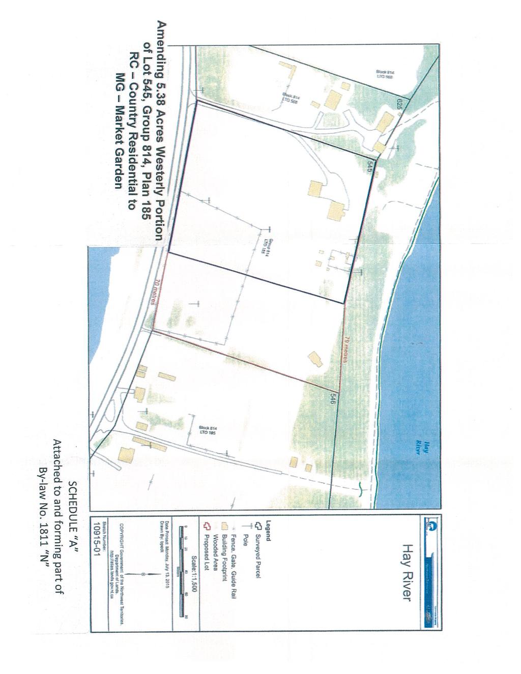
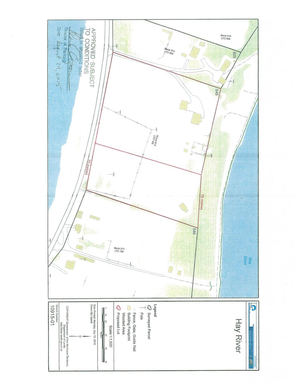
Town of Hay River. General Plan Bylaw No Town of Hay River
|
|
|
- Gwenda Webb
- 5 years ago
- Views:
Transcription
1 General Plan Bylaw No Prepared for Town of Hay River Prepared by UMA Engineering Ltd. Telephone: Avenue Fax: Edmonton Alberta T5S 1G
2
3 General Plan - Bylaw No Table of Contents Page No. 1.0 Introduction Goals and Objectives Development Goal Development Objectives Growth Management Strategy Introduction Development Prospects Planning Targets Approach Planning Targets Opportunities and Constraints of the Natural Environment Opportunities and Constraints of the Built Environment Growth Management Strategy Staging Sequence Policies Residential Land Use Commercial Land Use Industrial and Transportation Land Use Parks and Open Space Special Planning Area 1: Mobile Home Park Institutional Uses Mixed Use Area Infrastructure and Municipal Services Transportation Health and Safety Resource Use Area Implementation Plan Amendments and Review Development Schemes Municipal Land Development Private Land Development Zoning Bylaw Capital Plan Public Consultation Monitoring and Review _GENERAL PLAN i
4 General Plan - Bylaw No List of Tables Table Planning Targets and Residential Requirements List of Figures Figure 1 - Land Use Concept - North Figure 2 - Land Use Concept - South Figure 3 - Special Planning Area 1 - Development Staging Figure 4 - Special Planning Area 1 - Redevelopment Concept 1811_GENERAL PLAN ii
5 General Plan - Bylaw No Introduction 1. The Hay River General Plan is a statement of the Town's goals, aims and policies adopted by Council under the Planning Act (1988) of the Government of the Northwest Territories. The purpose of the General Plan is to guide decisions regarding the future development and redevelopment of the community. The General Plan is based upon an analysis of past and anticipated growth patterns, an evaluation of current land use policies and a consideration of significant community concerns. 2. The requirements for a General Plan as outlined in Section 4 of the Planning Act of the Northwest Territories are as follows: (a) (b) a General Plan is to be prepared by qualified planners appointed by and responsible to the council of the municipality, and a General Plan is to be based on studies of land use, population growth and the economic base of the municipality and municipal needs for transportation, communication and community services. 3. According to the Planning Act, the General Plan shall include: (a) (b) (c) (d) (e) (f) a map showing the municipality divided into permitted land use classes, proposals for the Zoning Bylaw, proposals for the provision of community infrastructure and services, a schedule for the sequence of development of land and supporting infrastructure, proposals for financing of public development projects, and other materials as deemed necessary. 1811_GENERAL PLAN 1-1
6 General Plan - Bylaw No The Planning Act also requires that a General Plan shall be reviewed every five years following its adoption (Section 6). The Town's previous General Plan and Zoning Bylaw were adopted in 1994, hence the need for review and revision. 5. The annexation of the Hay River Corridor, effective January 1, 1992, doubled the size of the Town and made it desirable to merge the planning and zoning controls for the corridor with the Town's General Plan and Zoning Bylaw. 6. This General Plan has an accompanying Background Report which contains the technical description and analysis which is the basis for the General Plan. The Background Report also documents the process by which both the General Plan and Zoning Bylaw were prepared. 7. The Zoning Bylaw was also revised concurrently with the General Plan. 1811_GENERAL PLAN 1-2
7 General Plan - Bylaw No Goals and Objectives 2.1 DEVELOPMENT GOAL 1. To coordinate and manage growth and land use in the Town of Hay River to ensure that both the Town's short and long term land use demands are satisfactorily met in an environmentally sound manner. 2. To establish a framework for planning, coordinating and evaluating proposals for development and land use change in the Town of Hay River, considering the short and long term implications of such development along with the collective needs and aspirations of the community. 2.2 DEVELOPMENT OBJECTIVES 1. To identify and direct a variety of land uses to appropriate sites and areas within the Town that are in keeping with the interests of the residents, land owners, and affected agencies. 2. To base land use and development decisions on the following criteria: (a) (b) (c) sound planning principles including: the avoidance of undesirable land use conflicts, the coordination of road networks, the health, safety and quality of life of residents, the protection and conservation of the natural and built environment, financial and economic considerations including: the location of tax generating business and industry, cost of municipal servicing, and compatibility with the objectives of other jurisdictions: territorial, federal and First Nations government. 1811_GENERAL PLAN 2-1
8 General Plan - Bylaw No Within this framework, the general land use objectives can be defined as the following: (a) (b) (c) (d) to ensure that land and services required for growth are identified and protected for all anticipated development, to maintain and enhance the quality of existing developed areas, to protect environmentally sensitive lands, resource areas, and potential hazard areas from the impacts of development and land use changes, and to provide a framework for inter-governmental and inter-agency cooperation, implementation and review. 1811_GENERAL PLAN 2-2
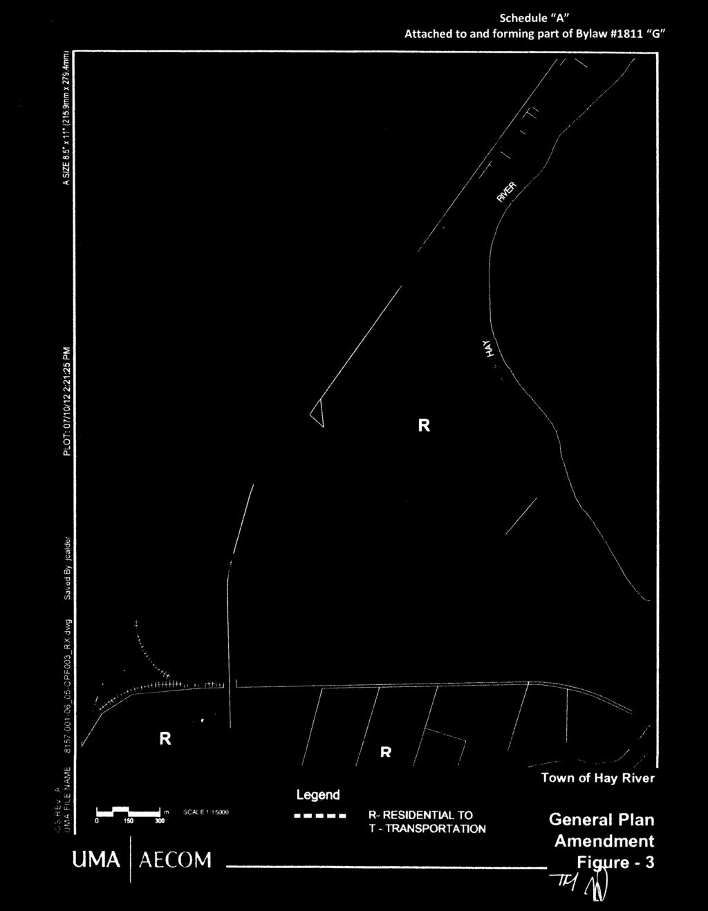
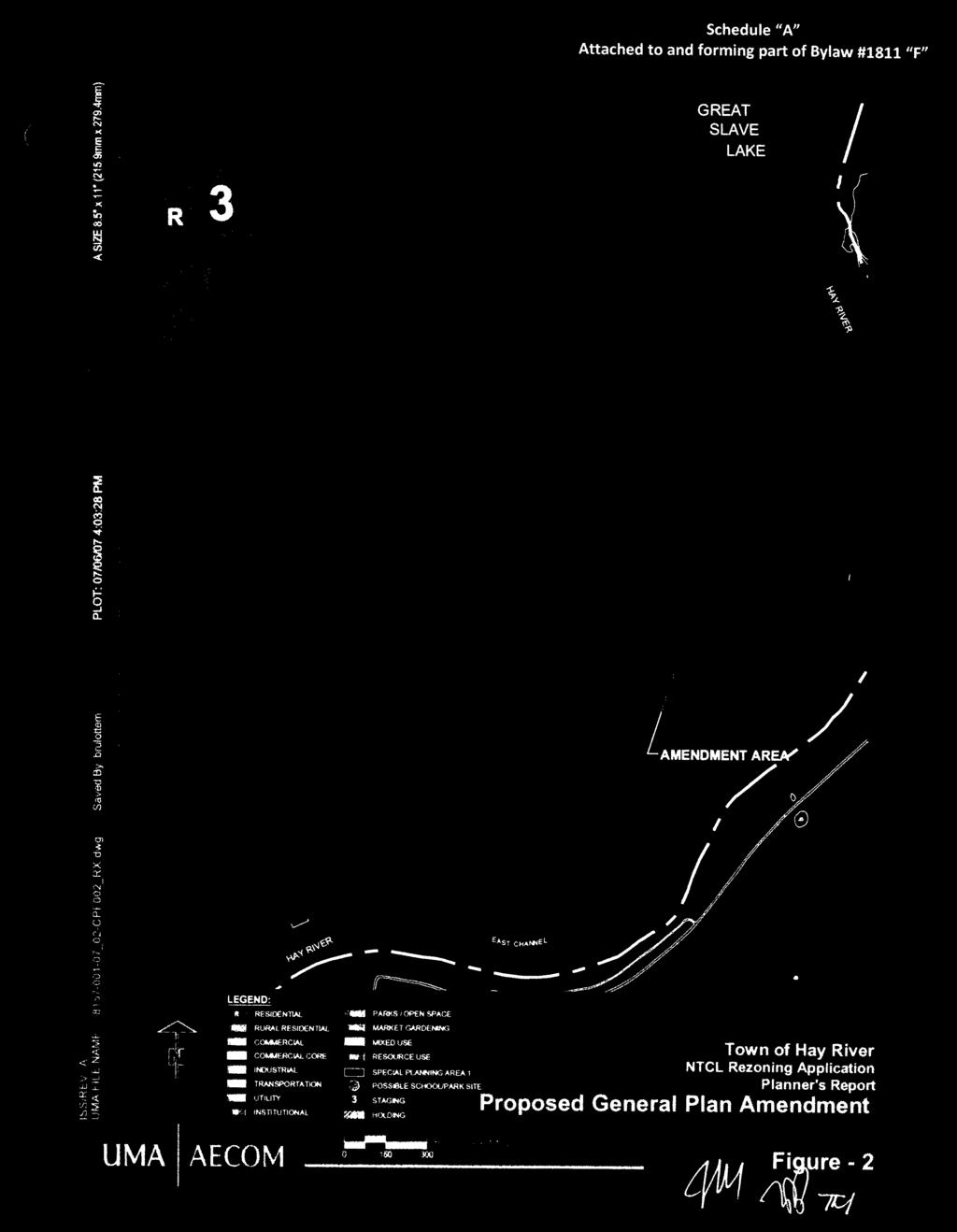
9 General Plan - Bylaw No Growth Management Strategy 3.1 INTRODUCTION This section presents a Growth Management Strategy for the Town of Hay River. This strategy is based on a consideration of three important factors: (a) (b) (c) past development trends, future growth prospects and defined planning targets, the constraints and opportunities of the natural environment which affect the future pattern of Town development, and opportunities and constraints of the built environment which affect the future pattern of Town development. The General Plan Land Use Concept (Figures 1, 2 and 3) displays the essential features of the Growth Management Strategy in graphic form. 3.2 DEVELOPMENT PROSPECTS 1. Hay River is very well positioned to benefit from the resource development and other economic development opportunities which the Northwest Territories. The following factors provide optimism for the Town s future: Hay River s strategic location as a trans-shipment point at the hub of major road, rail and water transportation routes in the north, and its strong function as a port serving shipments to Great Slave Lake, the Mackenzie River and the Arctic Ocean; Hay River s diversified economy, strong private sector and headquarters for several major businesses and capacity for providing business and industrial services; Hay River s role as the retail and service centre for the South Slave region; Hay River s attractive and wide range of community services; and Hay River s low cost of living relative to other Territorial centres. 1811_GENERAL PLAN 3-1
10 General Plan - Bylaw No The rapid and simultaneous development of oil and gas production, the Mackenzie Valley pipeline project, the diamond mining industry and base metal production at Pine Point and other northern locations would provide a strong positive impetus for growth in Hay River. 3. The Growth Management Strategy presented in the following sections is intended to provide a framework for anticipating and dealing positively with a range of positive growth scenarios. 3.3 PLANNING TARGETS APPROACH 1. The planning approach taken in this General Plan review is to establish planning targets related to specific population levels. Each planning target can then be related to specific land use, infrastructure and transportation requirements. This approach avoids over-reliance on population projections which have difficulty, especially in the north, with estimating the effect of migration. 2. The planning target for Hay River has been established at a population of 20,000, with a base population of 4,000 and intermediate population targets of 5,000; 7,500; 10,000; and 15,000. This review establishes the approximate residential land requirements for each of these target populations, and identifies the land needed to meet these requirements. The Growth Management Strategy identifies a logical sequence of development based on considerations of environmental, land use and infrastructure factors. 3. By continually monitoring the rate of population growth, the Town is able to estimate the time when these targets may be achieved. 1811_GENERAL PLAN 3-2
11 General Plan - Bylaw No PLANNING TARGETS The population targets are presented in Table 3.1 and summarized below. Housing and residential land needs are stated as well, as residential land is the larger component of urban expansion. Requirements for other land uses as well as community infrastructure and transportation requirements are discussed in subsequent sections and policy statements. Table Planning Targets and Residential Requirements Base Year Planning Stages Subtotal 4 5 Subtotal Total Population 4,000 5,000 7,500 10,000 15,000 20,000 Population Increase 1,000 2,500 2,500 6,000 5,000 5,000 10,000 16,000 Dwelling Units Needed ,500 1,250 1,250 2,500 4,000 Land Needed: hectares ,000 1,600 Land Needed: acres ,500 1,250 1,250 2,500 4,000 The five planning targets or stages of expansion are as follows: Stage 1. Population growth from 4,000 to 5,000, an increase of 1,000 from the base population, and requiring about 400 dwelling units and 40 hectares (100 acres) of residential land. Stage 2. Population growth from 5,000 to 7,500, a further increase of 2,500 from Stage 1, requiring a further 1,000 dwelling units and 100 hectares (250 acres) of residential land. Stage 3. Population growth from 7,500 to 10,000, a further increase of 2,500 from Stage 2, requiring a further 1,000 dwelling units and 100 ha (250 acres) of residential land. Stage 4. Population growth from 10,000 to 15,000, a further increase of 5,000 from Stage 3, requiring a further 2,000 dwelling units and 200 ha (500 acres) of residential land. 1811_GENERAL PLAN 3-3
12 General Plan - Bylaw No Stage 5. Population growth from 15,000 to 20,000, a further increase of 5,000 from Stage 4, requiring a further 2,000 dwelling units and 5,000 from Stage 4, requiring a further 2,000 dwelling units and 200 ha (500 acres) of residential land. To summarize, the growth from the base population of 4,000 to the 20,000 population would require 6,400 dwelling units and occupy 640 ha (1,600 acres) of land. The Land Use Concept (Figures 1, 2 and 3) displays the extent and location of lands to meet these growth targets. 3.5 OPPORTUNITIES AND CONSTRAINTS OF THE NATURAL ENVIRONMENT The Future Land Use Concept for the Town of Hay River is based on an understanding of a number of key environmental considerations which have and will continue to shape the form of the town. These are identified below. (a) The land most suitable for development in terms of soil and drainage conditions occupies a belt of lands running parallel to Hay River. This pattern has had a great influence in determining the linear pattern of existing urban development. Poorly drained lands to the west create a constraint to further economical westward expansion. (b) (c) The better drained land also has the highest agricultural capability. Longterm plans must maintain a balance between urban development needs and the opportunities for expanded agricultural production. Substantial areas of Vale Island are flood prone; they lie within the flood fringe of the 1:100 flood. Development within the flood fringe is subject to regulatory measures to reduce the risk of property damage due to flooding. 1811_GENERAL PLAN 3-4
13 General Plan - Bylaw No (d) (e) Discontinuous permafrost requires special treatment to allow development to occur; either advance clearing and drainage to encourage thawing, or insulation of foundations to prevent thawing. These approaches add to the cost of urban development. The Town of Hay River enjoys extensive shoreland areas, both along Hay River and along Great Slave Lake. These areas create a significant amenity for the town while requiring protection for aesthetic, ecological and erosion control reasons. 3.6 OPPORTUNITIES AND CONSTRAINTS OF THE BUILT ENVIRONMENT 1. The pattern of existing development also affects the direction of future development. The following land use and development factors influence the future pattern of development of the Town of Hay River. (a) The Airport constrains development in two ways. First, the Zoning Plan for the Airport places certain restrictions on development to protect approaches and navigational devices from incompatible land use. Second, the ownership of land by the airport authority precludes it from being developed. The most significant effect is that the lands along the west bank of the West Channel are precluded from development. These lands are particularly suitable for development as they are well drained and possess river frontage. (b) (c) Various perceived nuisance land uses such as the sewage lagoon, intensive livestock operations and landfills require locations away from residential areas. These uses are surrounded by setbacks which limit certain types of development within the radius of the setback. Existing roads, power lines and other utility lines enhance opportunities for development. In an area where development costs are relatively high, the existing road and service network act as a magnet to define the direction of further development. 1811_GENERAL PLAN 3-5
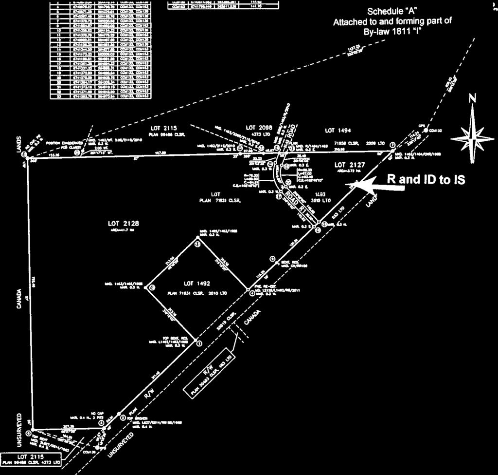
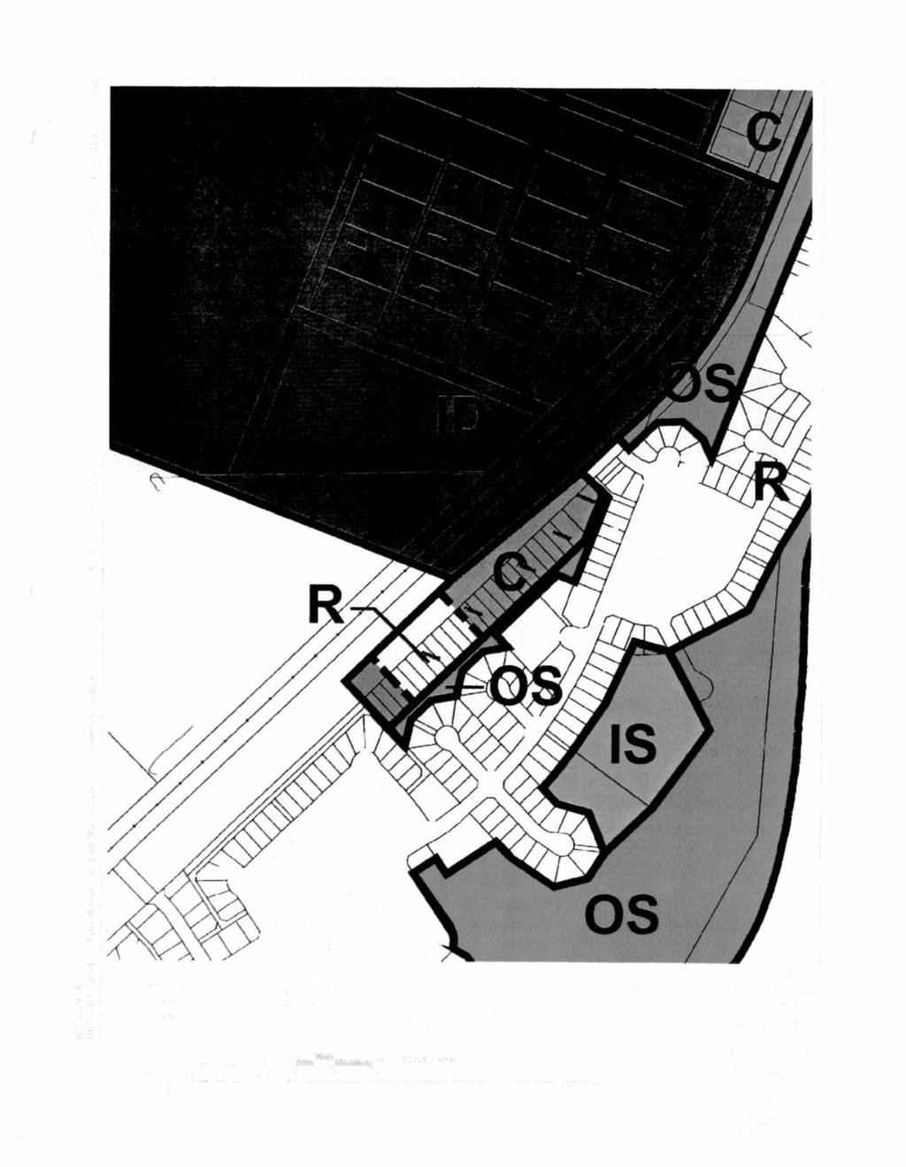
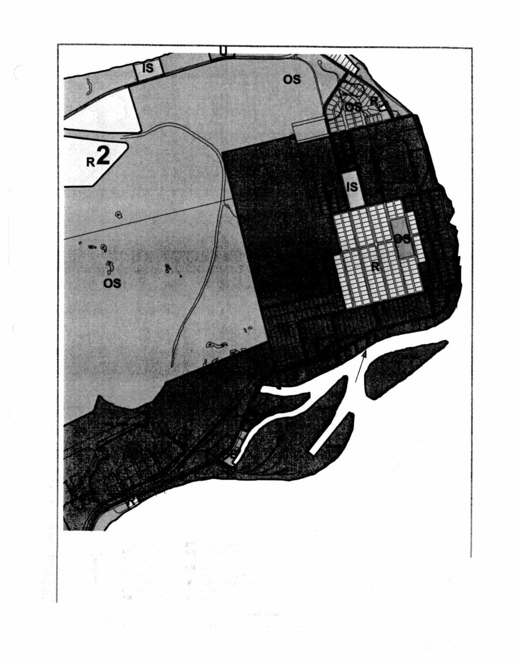
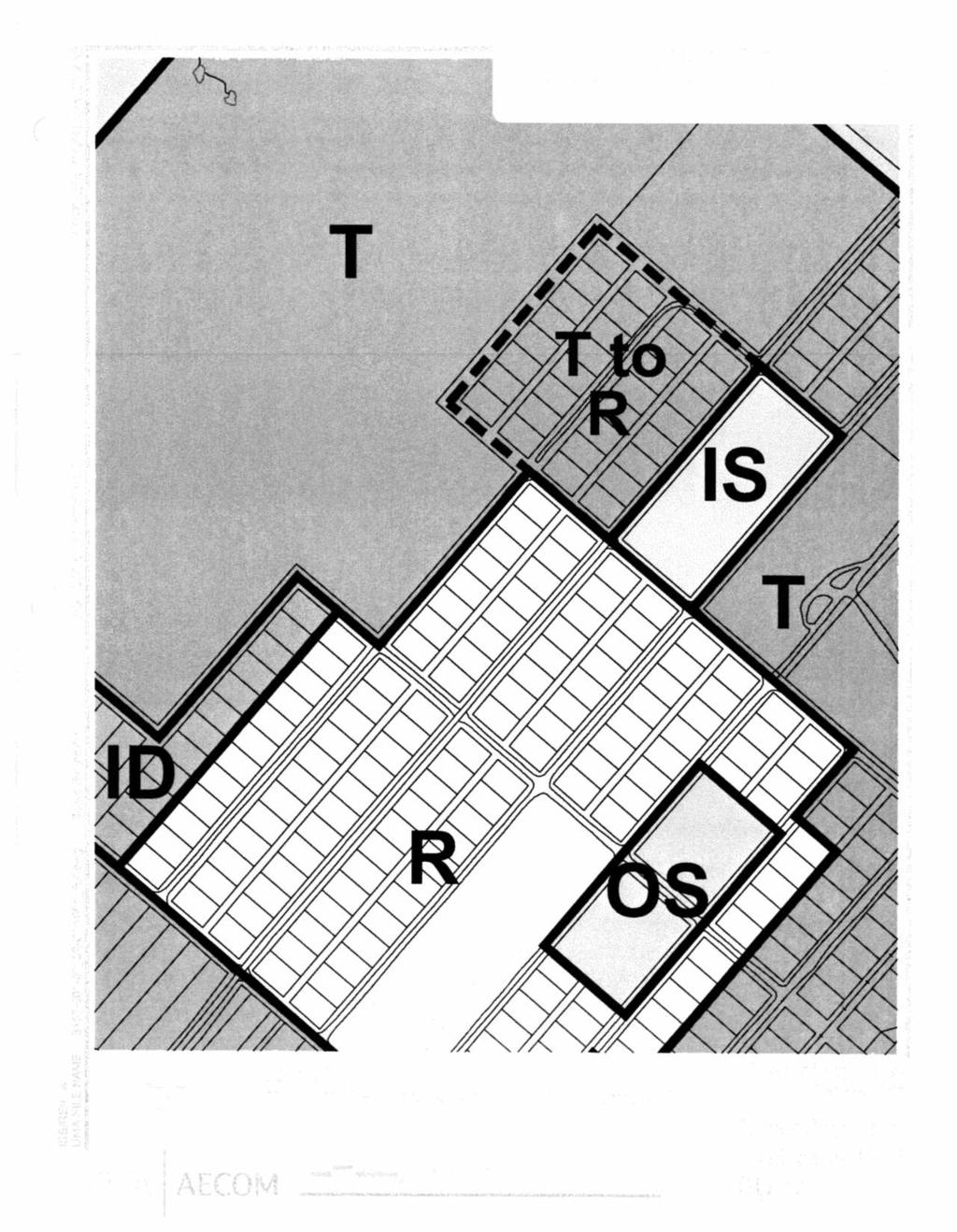
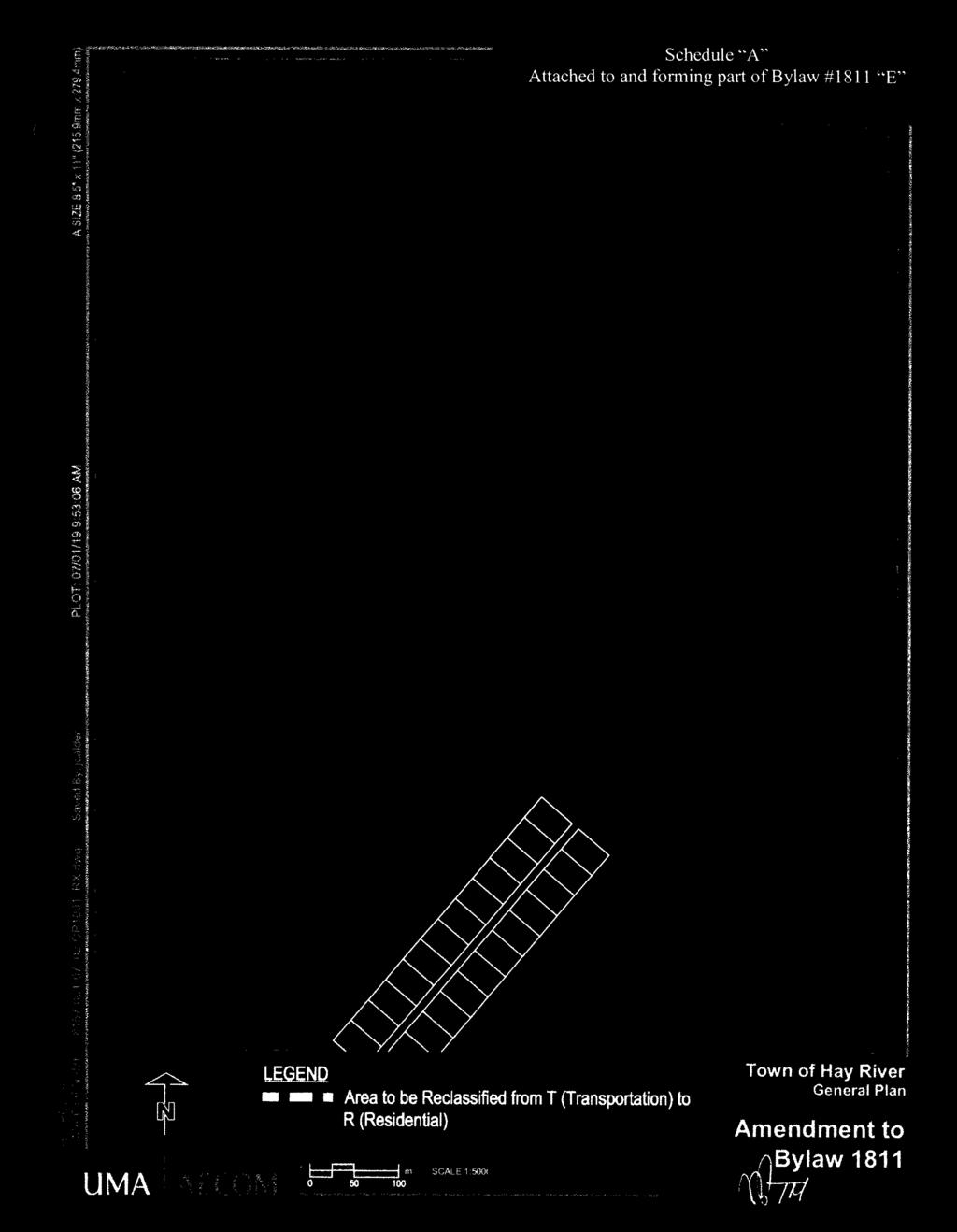
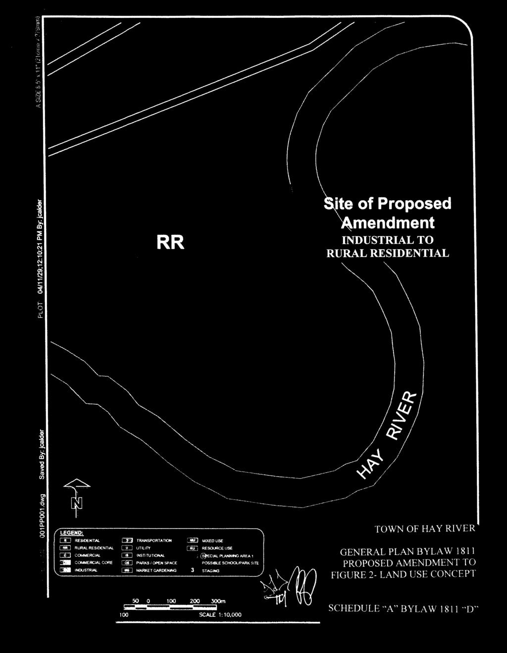
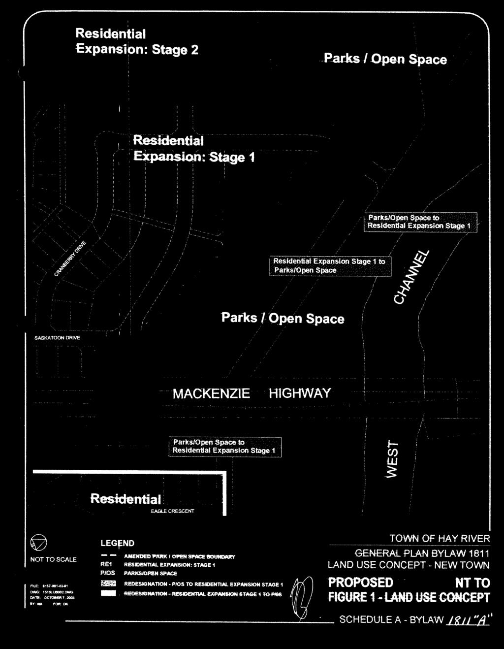
14 General Plan - Bylaw No GROWTH MANAGEMENT STRATEGY STAGING SEQUENCE Following from the previous discussion, a staging sequence is suggested which generally follows a north to south direction, following the path of land more suitable for development and the economic and orderly expansion of infrastructure. Stage One: Population Growth from 4,000 to 5,000. This stage would include further development of Area 1 (Northwest/Lot 553), initial development of Area 2 (Riverbend West) and initial development of Area 3 (West Point First Nation). Stage Two: Population Growth from 5,000 to 7,500. This stage would include further development of Areas 1, 2 and 3. Stage Three: Population Growth from 7,500 to 10,000. This stage would include completion of Areas 1 and 2, and continuation of Area 3 as per need. As Area 3 approaches completion, planning for Area 4 (Mile 5 West) and servicing of the Mile 5 area would be initiated. Stage Four: Population Growth from 10,000 to 15,000. Stage 4 would include the complete development of Area 4 and substantial completion of Area 5 (Mile 5 South). Stage Five: Population Growth from 15,000 to 20, ,000 to 20,000, Stage 5 would include the complete development of Areas 6 (Trianble West), Area 7 (Delancey West) and 8 (Delancey East). The General Plan Land Use Concept has been modified to designate these stages for future urban residential development. 1811_GENERAL PLAN 3-6
15 General Plan - Bylaw No The Land Use Concept designates the large triangular area defined by Mackenzie Highway, Highway 5 and the former Pine Point Railway as a mixed use area intended to be developed primarily as part of Stages 4 and 5, although some initial development has already been initiated. The land uses that may be included within the mixed use area include light industrial, commercial, institutional and residential. The staging sequence may be modified as more information on the technical and financial feasibility of developing Stages 4 and 5 at an earlier time is made available. If proven to be feasible, Stage 4 could proceed concurrently with or prior to Stages 1 or 2. More detailed Policy Guidelines regarding specific land uses are presented in the following sections of this General Plan. 1811_GENERAL PLAN 3-7
16 General Plan - Bylaw No Policies These policies provide more specific direction for the future development of the Town of Hay River within the context of the Goals and Objectives and the Growth Management Strategy presented in Sections 2.0 and 3.0. The Policies are shown graphically on a Land Use Concept plan which is appended as Figures 4-8. All lands within the Town of Hay River are designated into general land use classes as shown on Figures 1 and 2 Land Use Concept. The Land Use Concept divides all lands within the Town of Hay River into general land use classes. These land use classes are as follows: 1. Residential 2. Rural Residential 3. Core Area Commercial 4. Highway Commercial 5. Industrial 6. Transportation 7. Park/Open Space 9. Special Planning Area Institutional 11. Utility 12. Market Gardens 13. Resource Use 14. Future Mixed Use 15. Holding 1811_GENERAL PLAN 4-1
17 General Plan - Bylaw No Additional policies address related issues of transportation, infrastructure and implementation. 4.1 RESIDENTIAL LAND USE General 1. The purpose of this land use area as designated on the Land Use Concept is to protect existing residential areas and to designate future areas for residential use. The Residential land use area provides for a wide variety and mix of housing types including single detached, semi-detached and duplex housing, attached housing including row housing and apartments and manufactured homes. Other related uses which may be suitable within the Residential land use include parks, schools, places of worship, home occupations, bed and breakfasts and neighbourhood convenience stores. 2. A comprehensive Concept Plan shall be prepared for all or a portion of each successive stage of residential development prior to development. The area to be included in each Concept Plan shall be determined by the Town, based on the anticipated development needs. The Concept Plan shall be based on appropriate geotechnical, topographic, infrastructure and transportation analysis as determined by the Town at the start of the concept planning process. The Concept Plan shall show the following: the type and mix of land uses including single and multi-family residential, institutional, parks and open space, neighbourhood commercial, stormwater management and other land uses; the circulation system including vehicular and pedestrian circulation; proposals for the interface with adjacent land uses; and other matters as required by the Town of Hay River. 1811_GENERAL PLAN 4-2
18 General Plan - Bylaw No The Concept Plan shall be approved by resolution of Council and shall provide the framework for further rezoning and subdivision applications. 3. The Town shall ensure that an adequate inventory of subdivided and serviced residential land is available in sufficiently advance of demand to avoid shortfalls in supply. The Town shall monitor the inventory of available residential land through the land sale and development permit processes to ensure an adequate inventory exists. 4. The Town shall provide sufficient lead time for the necessary geotechnical analysis, planning, design and site preparation for development to occur in a staged sequence. Land will be cleared sufficiently in advance to allow for thawing of permafrost and for proper drainage. 5. For new residential development adjacent to industrial areas, special attention will be given to the transition between residential and industrial land use to mitigate or avoid any potential land use conflicts. Possible approaches may include treed buffers of appropriate width, spatial separation, an intervening roadway, added depth to lots backing onto industrial areas, stormwater management facilities, limited roadway connections between residential areas or a combination of these approaches depending on specific circumstances. two or more of these approaches. Two situations where this will be required are the north and south limits of the New Town Industrial Park adjacent to and the future Lot 553/Northwest and Riverbend West residential development areas respectively. The interface between these land uses will be addressed through the Concept Plans for the respective residential areas. 1811_GENERAL PLAN 4-3
19 General Plan - Bylaw No Future Residential Development 6. The Town will provide opportunities for a range of housing types and densities to accommodate diverse market preferences. The Zoning Bylaw may distinguish residential areas by housing size and type, lot size, lot dimensions and level of servicing. 7. Densities and housing form in new residential areas will be determined primarily by the anticipated market conditions and community preferences as indicated within the Concept Plan for the new area. Lot 553 is intended for a mix of mobile homes, manufactured homes and conventional single family housing. However, manufactured homes may be located in other areas, depending on market conditions and community preferences, as directed by the Concept Plan for the particular new residential area. 8. The Town will support the infilling and redevelopment of residential areas wherever possible in order to maximize use of existing infrastructure where this can be done without disrupting the amenity of the residential neighbourhood. 9. Any higher density residential uses, including mobile home parks and multifamily sites shall only be permitted where they can be adequately serviced and have access to community amenities such as schools, parks, and commercial facilities. Multi-Family Residential Development 10. The Town will maintain an adequate inventory of lots suitable for a range of multi- family residential developments. 1811_GENERAL PLAN 4-4
20 General Plan - Bylaw No The Town will permit multi-family residential development on any land designated Residential where: a) there is good access to and from collector streets, b) there is minimal effect on neighbouring lower-density residential areas, c) community amenities and services are readily available, and d) adequate servicing capacity exists. 12. Areas for multi-family development will be designated in the Concept Plans for new residential areas in accordance with anticipated market demand and the principles stated in Policy above. Home Occupations 13. The Town recognizes the growing significance of home occupations and home businesses to contemporary economic development. The Town will continue to permit home occupations of a type and scale which are consistent with the character of the residential environment and which do not adversely effect adjacent residential development. Manufactured Housing 14. The Town recognizes the convenience and affordability of manufactured housing and will continue to plan for manufactured home subdivisions and manufactured home parks in appropriate locations and as required by community need. Group Homes 15. Group homes will be sited carefully to ensure they are dispersed throughout all residential areas. 1811_GENERAL PLAN 4-5
21 General Plan - Bylaw No Within the expansion areas of Riverbend South, Riverbend West and Lot 553, lands shall be allocated through subdivision design and designated by the zoning bylaw for institutional and/or residential use to accommodate new larger group homes which may not fit as readily into established residential neighbourhoods. Public Housing 17. The Town will coordinate its efforts with the Northwest Territories Housing Corporation to ensure appropriate sites are provided for a variety of types of public housing. Mile 5 Area The design of public housing units should be compatible with, and complementary to, surrounding housing development. 18. The Mile 5 area will continue as a low density residential area providing larger lots without piped water and sewer services. Duplexes or semi-detached dwellings may be allowed in selected locations at the discretion of Council provided that there is minimal effect on neighbouring residential areas, the buildings are compatible in appearance with other residences in Mile 5 and satisfactory arrangements can be made for the provision of municipal services. 19. The existing commercial, institutional (not including churches) and industrial uses, excepting those located on Lot 1593, Plan 2238, located in Mile 5, shall be encouraged to relocate in the long term, and the Town shall support their eventual conversion to residential land use. 20. The Town shall negotiate with the Government of the Northwest Territories for the eventual relocation of the Forestry Centre and its conversion to residential development. 1811_GENERAL PLAN 4-6
22 General Plan - Bylaw No Vale Island/West Channel Village 21. As shown on the Land Use Concept, the area designated Residential has been expanded to include several former non-conforming residential properties to the east of 100th Street. 22. The Town shall encourage the relocation of the remaining non-conforming residential pockets from the Vale Island industrial areas. 23. Further residential development within the Old Town on Vale Island will be limited to infill of existing subdivided properties. 24. The West Channel Village will continue to provide an alternative residential location. A modest expansion to the south of the existing subdivided area has been designated on the Land Use Concept and the Zoning Bylaw. The expansion is located on higher land and has existing infrastructure in place. 25. The West Channel Village will remain as an unserviced community. Standards for the outdoor storage of material and equipment related to the fishing industry shall be less restrictive than other residential areas of the community. 26. Within the West Channel Village, Council will seek to achieve the long term goal of creating and maintaining as open space the lands lying between Mackenzie Drive and shoreline of the West Channel of the Hay River. This goal will be achieved through a program of a) placing a freeze on the sale of any further Town-owned lots; and b) strategic acquisition of properties as they become available. Affected land owners will be consulted to determine and obtain their support. 1811_GENERAL PLAN 4-7
23 General Plan - Bylaw No The justification of the program will be determined by a comparison of its costs with the annual and cumulative costs of flood management, flood damage and risk minimization. 27. The core area of Old Town shall be protected and enhanced for residential uses by strict enforcement of the flood risk area regulations. West Point First Nation 28. A portion of land south of Lakeshore Drive, across from the current West Point First Nation community area is designated Residential on the Land Use Concept for the long-term community needs of the First Nation. This are will complement the existing First Nation lands to the north of Lakeshore Drive. 29. A Concept Plan for the new area shall be prepared prior to any rezoning or subdivision of land. 30. The Concept Plan may also address potential community facilities such as day care, neighbourhood commercial or other uses which the First Nation may wish to incorporate into their community area. 31. The area of land north of Mackenzie Highway, and between the current West Point First Nations and the former scatter site are designated as Holding, to signify the continuing interest of the West Point First Nation in this land. However, the ultimate use shall be open space. Within this area, public access shall be maintained along the shore of Great Slave Lake. Rural Residential 32. Lands designated as Rural Residential on the Land Use Concept will be maintained for rural residential purposes. 1811_GENERAL PLAN 4-8
24 General Plan - Bylaw No The Town may investigate the development feasibility of an additional rural residential area located on the northern portion of the Hay River Golf and Country Club site. Factors of the site suitability, development costs and market potential will be considered in the decision to develop this opportunity. A rural residential development at this location will not limit the expansion of the golf course to 18 greens and may be undertaken in conjunction with golf course expansion. 34. Any new rural residential areas shall provide for a variety of lot sizes, maximum exposure to natural amenities and opportunities for raising some animals. 4.2 COMMERCIAL LAND USE Core Area 1. The Town shall ensure that the central commercial core, identified as Core Area on the Land Use Concept, remains as the major retail, service and office focus of the community. The Core Area also provides residential development opportunities. 2. The Town shall continue to protect the vitality of the Core Area lands for those purposes. 3. The Town shall continue to promote infilling of the Core Area before expansion. 4. The redevelopment of the former Don Wright Park or South Downtown as a commercial area is a major initiative to complement and expand the downtown area. The following objectives are established for this portion of the downtown: 1811_GENERAL PLAN 4-9
25 General Plan - Bylaw No (a) (b) (c) (d) (e) (f) (g) (h) (i) (j) (k) an overall attractive appearance and compact form, complementary and harmonious building style, storefront continuity at the street level, provision for second and third level uses, adequate customer and employee parking, appropriate riverbank development, strong visual and functional linkages with the river and the riverbank and the retention of civic open space along the river bank for public use, strong functional linkages with businesses and services within the developed core area, opportunities for residential use on upper levels of buildings where appropriate in a mixed use setting, parking structures incorporated into buildings below grade to lessen at-grade parking requirements, and a high quality of landscape development on public and private open spaces. 5. In order to achieve these objectives, the following policies are established: (a) (b) all buildings on interior lots will be encouraged to build to the front lot line to achieve store-front continuity, all buildings on interior lots will be encouraged to build to the side lot line except where a mid-block pedestrian linkage is established. 1811_GENERAL PLAN 4-10
26 General Plan - Bylaw No Further multi-family housing may be permitted in the commercial core area on lots between Capital Crescent and the Hay River in accordance with the C3 - Mixed Use Commercial zone regulations of the Zoning Bylaw. Multifamily housing which is part of a mixed use development with commercial uses on the ground floor will be encouraged and is a permitted use in the C3 - Mixed Use Commercial Zone. Freestanding multi-family housing may be permitted within the C3 zone at the discretion of the Council. In dealing with a discretionary use application for freestanding multi-family development, Council will ensure that the long term commercial space needs of the Town are not compromised. Multi-family housing in other parts of the commercial core area may be considered if Council is satisfied that the long term commercial space needs of the Town will not be compromised. The development of multi-family housing will require rezoning of the subject property to the C3 - Mixed Use Commercial zone. 7. The long-term expansion of the commercial core in addition to the South Downtown area may occur in one or both of two directions as follows: (a) (b) to the north between Woodland Drive and the rail line, and to the west across Mackenzie Highway and the CN Rail line through intensification of uses within the Industrial Park. The timing of such expansion will depend on demand, access, traffic impact, development feasibility, potential impact on the viability of the existing commercial core area and the impact on the land uses within and adjacent to the expanded core area. 1811_GENERAL PLAN 4-11
27 General Plan - Bylaw No Future Commercial Areas 8. Existing and future highway commercial lands are identified as Highway Commercial on the Land Use Concept. 9. The zoning bylaw will contain provisions to ensure an attractive appearance of all highway commercial properties. 10. A location for future commercial use has been designated west of the Mackenzie Highway and Mile 5 on the Land Use Concept. It is anticipated that this location would be required for development as part of Stage 4 (10,000 to 15,000 population) development. However, the timing of such development may be advanced depending on the supply and demand for commercial lands within the commercial core and highway commercial areas. Development of this area shall consider the feasibility of extending services and the neighbouring residents in the Mile 5 area. 11. The Town shall develop additional rail crossings and pedestrian linkages, as feasible, to increase the accessibility and exposure of properties west of the rail line and to facilitate their development for commercial and industrial uses. Neighbourhood Commercial 12. Commercial sites, limited to neighbourhood convenience commercial uses, should be considered at appropriate locations in the Concept Plans for future residential areas. Such sites should be located on corner lots on major streets and on or near major intersections within the neighbourhood. Neighbourhood commercial sites should be designed to be compatible with the residential nature of the neighbourhood. Caretaker Units 13. Caretaker units may be allowed in highway commercial developments where they are designed and integral components of the main building. Separate caretaker units will not be allowed within the highway commercial zones. 1811_GENERAL PLAN 4-12
28 General Plan - Bylaw No INDUSTRIAL AND TRANSPORTATION LAND USE 1. Lands designated for short and long term industrial and transportation land uses are shown on the Land Use Concept as Industrial and Transportation. 2. The lands designated Transportation and Industrial on Vale Island are intended for transportation land use such as the port and the airport as well as other industrial uses related to the road, rail, water and air transportation function of Hay River. Such uses may include storage, warehousing, trucking, fabrication or other land uses related to the trans-shipment of goods to and from the north. 3. An additional area on Vale Island formerly designated Residential is designated as Transportation to ensure that adequate land is available for industrial development related to resource development in the north and Hay River s transportation function. 4. The New Town Industrial Park is designated Industrial to serve variety of light industrial land uses. Adequate land is designated to allow for expansion for all stages of anticipated growth and to provide both fully serviced industrial areas as well as industrial uses requiring lower levels of servicing, large parcel sizes and greater separation from residential areas. 5. The Town shall ensure the availability of sites which can be developed in the short term without major site preparation. Some lots should, where practical, be pre-filled. 6. Light industrial development may also be permitted in the Mixed Use development of the triangle area, as part of Stage 5 of the development sequence. The location of such development should be more clearly defined through the preparation of a Concept Plan for the triangle area. 7. The Town should continue its economic development planning to enhance and diversify the industrial sector of the Town. 1811_GENERAL PLAN 4-13
29 General Plan - Bylaw No The Town of Hay River shall encourage the further development of agricultural processing industries for local, territorial, national and international markets. The siting of agricultural processing industries shall take into account their potential impacts on residential or public use areas. 9. The Town may consider siting potential agricultural processing or other industrial facilities within the Resource Use area if a location within the designated Industrial or Transportation land use designations is not available. Such a location would be subject to conformity with planning and environmental principles and regulations. 10. The Town may allow caretaker units in industrial developments where they are designed and integral components of the development and restrict other caretaker units to mobile homes on year-to-year permits. The re-issuance of a permit will be decided each year by Council based on the circumstances of the situation and the need for its continuance. 11. Any redevelopment of the Freshwater Fish Marketing plant should recognize the proximity to the Lot 553 residential area and any uses which would adversely affect the residential environment should not be allowed in this location. 4.4 PARKS AND OPEN SPACE 1. Within the former Town boundaries, and except where specifically required for transportation, utility and community uses, the shores of the Hay River (both channels) and Great Slave Lake shall be designated for environmental protection and recreation use. These areas are designated as Parks/Open Space on the Land Use Concept. 2. The Town shall conserve a forested buffer along shoreline areas adjacent to new development within the former Corridor area. The width of such a buffer shall be appropriate to the topography and to adjacent land uses. 3. The Town shall continue to develop its recreational potential for both its residents and to promote the tourism industry. 1811_GENERAL PLAN 4-14
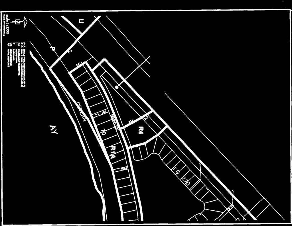
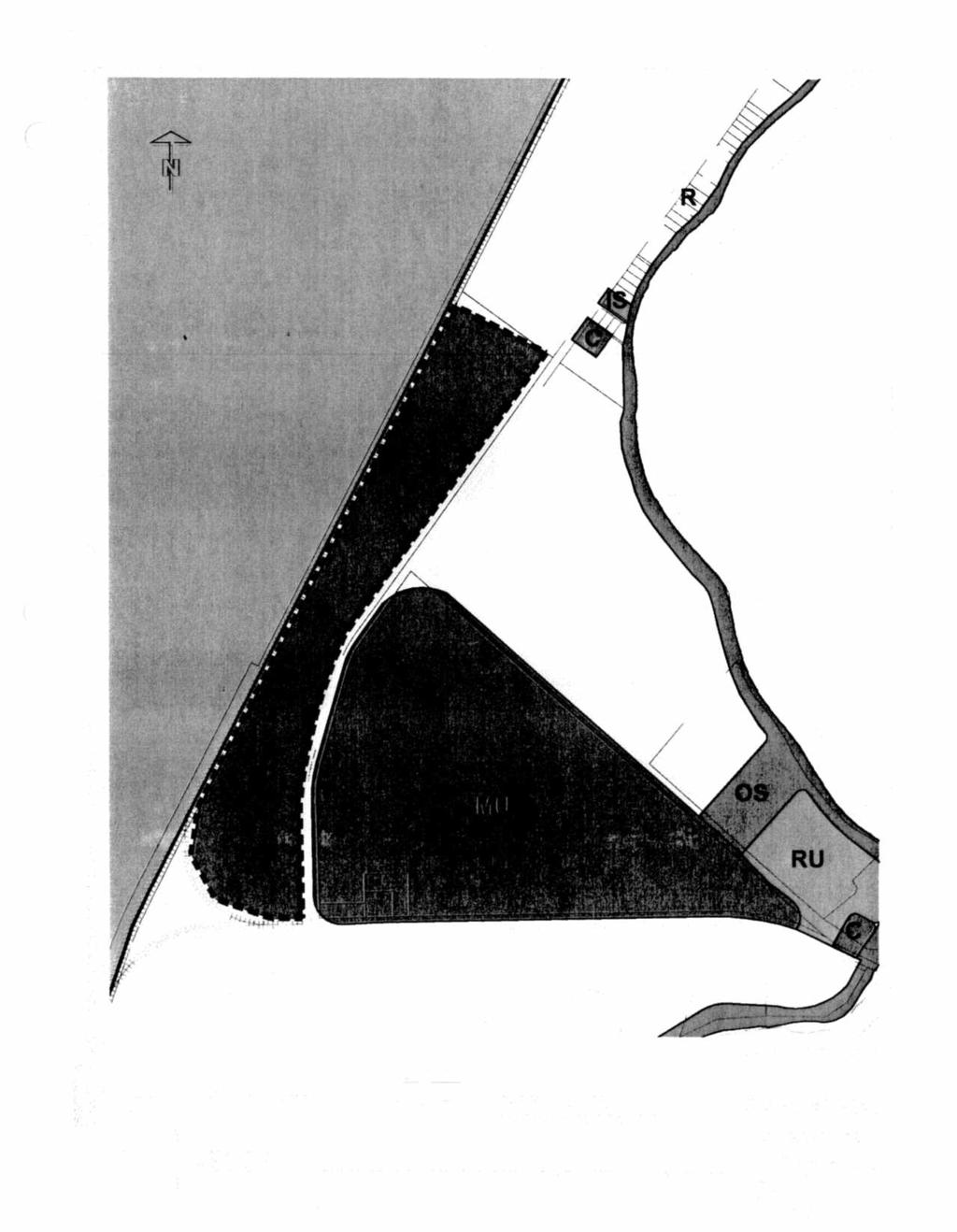
30 General Plan - Bylaw No The Town shall ensure that its parks and recreation plans are kept up to date and consistent with this General Plan. 5. New residential areas will be designed to provide local parks and recreation space for future residents. Ten per cent of land in or adjacent to new residential areas will be designated for parks and open space as well as neighbourhood schools where required. The allocation and function of open space at the neighbourhood level will be identified through the preparation of Concept Plans for new residential areas. 6. Future multi-family residential development will provide adequate open space and recreational amenities for use by its residents. 7. The community park located north of Lot 553 will replace the recreational facilities displaced by the South Downtown commercial development and will become major focus for recreational facilities and open space for the Town of Hay River. 8. The Town will work complete, maintain and expand a continuous open space and trail linkage system based on the existing Kiwanis Trail to connect the New Town with Vale Island and the shore of the Hay River and Great Slave Lake. 9. The Town will continue to integrate its trail system with the Trans-Canada Trail system. 4.5 SPECIAL PLANNING AREA 1: MOBILE HOME PARK 1. The current mobile home park located west of Woodland Drive and opposite the two elementary school sites is designated as Residential/Special Planning Area 1 by the Land Use Concept. 2. This parcel of land may be re-developed for multi-family development with re-development occurring through sequential rezoning to the R4 Zoning District and subdivision of the parcel, as required. 1811_GENERAL PLAN 4-15
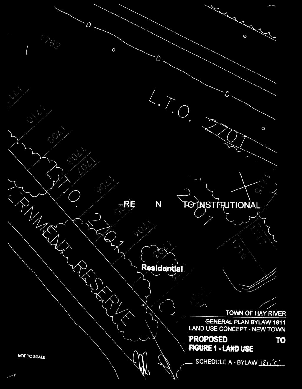
31 General Plan - Bylaw No The phasing of the redevelopment shall be as identified in Figure 3. The Mobile Home Park use will be maintained and the transition to multi-family use will proceed in an orderly fashion as demand dictates and in accordance with Figure The following issues shall be addressed to the satisfaction of the Development Officer and Council before any development on the property may proceed: a) the internal relationships of land use as the mixed use of the site is maintained; b) provision of services and utilities for the redevelopment; c) provision of landscaping and associated amenities; and d) conformance with all municipal and territorial legislation, regulations and policies. 5. The 0.15 ha area adjacent and west of the proposed 12.4 metre one way access, as shown on Figure 4, may be consolidated with the adjacent commercial land. 6. The development standards for new infrastructure shall be to the satisfaction of the Town, and the condition of the existing infrastructure for use shall be to the satisfaction of the Town. 4.6 INSTITUTIONAL USES 1. The Town shall maintain institutional uses for those areas designated Institutional on the Land Use Concept and provide adequate sites for new areas as required. 1811_GENERAL PLAN 4-16
32 General Plan - Bylaw No The Town, in consultation with the Hay River and Area Community Education Council, will plan for a site for a new elementary school in the Stage 2 Riverbend West residential development. The size and location of the site should be identified in the Concept Plan for Riverbend West. Alternate uses for the school site should be considered in the event a school is not needed at this location. 3. Potential locations for additional school/park sites are indicated on the Land Use Concept for the planning target population of 20, Consideration should be given to locating church sites in proximity to multifamily housing when in the preparation or revision of Concept Plans for new residential neighbourhoods. Town and educational authorities will continually monitor the need for new or expanded educational facilities to ensure that adequate lands are made available in the future. 5. The needs for social, cultural, educational and other institutional uses shall be carefully monitored and sites provided in new residential areas or other suitable areas. 6. Where institutional uses derive more than 10% of their total revenues from commercial activities which are not directly related to the particular facility, recommendations shall be made to locate such uses in a more appropriate commercial zone. 7. A new cemetery shall be identified in a suitable location. Factors to be considered in locating a new site shall include A well-drained site with good soil conditions; A peaceful quiet setting away from distracting development; Reasonable access by road with good linkages to places of worship and funeral chapels; and A site which is not required for future urban development. 1811_GENERAL PLAN 4-17
33 General Plan - Bylaw No The left bank of the West Channel may offer a number of suitable areas which meet site, access and land use criteria and are constrained from other land use by regulatory constraints of the airport. 8. Lot 1021 is designated for Institutional use. Development of the site will be compatibility with the Planning Report for the site completed in 2001, which indicated seniors housing as the highest priority for the site. 4.7 MIXED USE AREA 1. The Land Use Concept designates the triangular parcel of land defined by the Mackenzie Highway, Highway 5 and the former rail line as a Mixed Use area as part of Stage 5 (15,000 to 20,000 population) development. This area is sufficiently large to accommodate commercial, light industrial, institutional and/or residential uses and has excellent access. 2. The allocation and location of such land uses shall be determined through the Concept Plan to be prepared in advance of development. 3. Prior development of this area may be considered on a small-scale basis, provided that such development does not preclude future development opportunities, is compatible with adjacent Stage 4 and 5 residential development and can be economically serviced. 4.8 INFRASTRUCTURE AND MUNICIPAL SERVICES 1. The Town will continue to promote and enforce appropriate standards for the provision of sanitary sewage, including non-piped systems in Mile 5 and Vale Island and future country residential development. 2. The New Town residential areas will be serviced to the Town s standards for urban infrastructure. 3. The range of services, and the standards of that servicing, shall be limited in the remainder of Town to what can economically and practically provided. Where piped servicing is unavailable or impractical, trucked services shall be made available. 1811_GENERAL PLAN 4-18
34 General Plan - Bylaw No The Town shall provide sufficient lead time for geotechnical analysis, preliminary and detailed engineering design and site preparation to develop expansion areas in a timely and efficient manner. 5. Sites for utility uses are designated as Utility on the Land Use Concept where site locations have been determined. 6. The Town will continue to work towards a long-term new location for a solid waste management facility which can combine landfill, recycling and composting functions on a site which is large enough for long term growth of the Town and which is adequately separated from residential areas and water bodies. The Town will investigate the opportunity to integrate the disposal of animal manure by composting, land farming or other appropriate method, as part of the waste management facility. The examination of candidate sites may include sites beyond the current boundaries of the Town of Hay River, specifically Crown lands to the southeast. 7. The Town shall continue to progressively reclaim the current landfill site for future open space use complementary to Stage 5 residential development and to its riverbank setting, in anticipation of a long-term relocation to a new site. 8. The Town will address the need and feasibility for a new fire hall location which meets all relevant site and locational criteria. The Town will address future fire hall requirements in connection with the proposed stages of development to meet appropriate response time and public safety needs. 9. The Town will work towards a system of snow storage sites which reflect current and anticipated environmental standards, in locations which are compatible with surrounding land use. 1811_GENERAL PLAN 4-19
35 General Plan - Bylaw No TRANSPORTATION 1. The Town shall protect its transportation infrastructure in recognition of their important role in the Town's economy. 2. The Town shall endeavour to improve pedestrian access from Vale Island to the New Town through the implementation of the open space and trail corridor plan mentioned in Policy More specifically, the Town will work with the Department of Highways of the Government of the Northwest Territories to provide safe use of the bridge by vehicles, cyclists and pedestrians by a walkway along the side of the bridge. 3. The Town shall manage access to Mackenzie Highway, Highway No. 2, in accordance with its function as a primary highway within the territorial system and the major arterial for the Town of Hay River. Access to Mackenzie Highway for existing and future development will be in accordance with the appropriate access management standards and guidelines of the territorial government, the Transportation Association of Canada (TAC) and the Town s standards. 4. When required by need and by growth, the Town will prepare a transportation master to reflect the based on the direction and rate of growth presented by this General Plan. 5. The Town will work to secure additional rail crossing agreements to ensure convenient and emergency access to and from areas west of the rail line as required by the population and growth targets identified in this General Plan. 6. The float plane base, on the main channel of the Hay River, has been designated on the Land Use Concept for its continued use. 7. The Town shall enforce the parking provisions of the Zoning Bylaw and monitor the parking situation in the core area to ensure that problems do not develop and that an adequate supply of parking space is maintained. 1811_GENERAL PLAN 4-20
36 General Plan - Bylaw No The Town shall protect the airport by prohibiting development which could adversely affect the safe and efficient operation of the airport. 9. The Town shall protect the appearance and scenic attraction of the major highway entrances to the Town. 10. The Town shall provide safe and convenient pedestrian and bicycle linkages between residential areas west of the Mackenzie Highway and CN Rail line and the schools and community services to the east of the rail line. 11. The Town will support the concept of a bridge linking the Town with the Hay River Reserve. Such a bridge link and its access roads should be located, planned and designed to: (a) (b) (c) (d) be integrated with the existing road network and traffic flows; minimize risk of ice jams and hence flood risk; minimize disruption of land use patterns; and maximize convenience to residents of both sides of the River HEALTH AND SAFETY 1. The town shall not allow livestock within the residential areas on Vale Island because of the high water tables, the poor surficial drainage, the small parcels and relative density of the area. 2. The Town will strictly enforce the flood risk regulations to protect life and property. 3. Where there are no piped services, trucked services shall be provided to the quality and design standards of the Town to avoid any health risks or any adverse environmental impact. 1811_GENERAL PLAN 4-21
37 General Plan - Bylaw No RESOURCE USE AREA 1. The Town recognizes the Hay River Corridor as a special area comprising many rural residential, agricultural, industrial, recreational and resource developments, with significant opportunities for further agricultural development. In recognition of the multiple-use concept for non-urban areas, all lands not otherwise designated are designated as Resource Use on the Land Use Concept. 2. The Town recognizes the significant potential role of agricultural production to the diversification of its economic base and will support efforts to expand agricultural production. Agricultural land use will be considered of paramount importance within those areas which are not required for urban uses. Areas of higher-quality agricultural land are designated as Market Gardens on the Land Use Concept. 3. The Town shall identify and protect better quality agricultural land for agricultural production, except for those areas which are clearly required for future urban uses. Better quality agricultural lands are defined as those lands having a capability of Class 5 or higher as classified by Agriculture Canada's Soil and Soil Suitability Information Series, The Town shall not allow subdivisions, leases, or development in the area designated for any urban use by Land Use Concept which would prejudice future planning and development of the urban built-up area of the Town of Hay River. 5. The Town shall not allow subdivisions, leases or development outside of the built-up urban area which would require undue demands for services to be provided by the Town. 1811_GENERAL PLAN 4-22
38 General Plan - Bylaw No The Town will recommend to the Government of the Northwest Territories to review and revise its land tenure policies so as to encourage private investment in agriculture and the development of a viable agricultural production and processing industry. The Town will recommend to the Government of the Northwest Territories that it discontinue its "lease-only" policy within the boundaries of the Town of Hay River and make all lands available for purchase. 7. The Town shall continue to promote agricultural production and processing in order to diversify the economic base of the Town. 8. Because of their potentially adverse effects, intensive livestock operations will be allowed to locate only where they will not adversely affect other uses such as residential, recreational or public uses. The Town shall designate appropriate limiting distances between intensive livestock operations and residences within the zoning bylaw. In addition, applications for intensive will be referred to the appropriate public health and environmental authorities. 1811_GENERAL PLAN 4-23
39 General Plan - Bylaw No Implementation 5.1 PLAN AMENDMENTS AND REVIEW 1. Amendments to this plan may be made from time to time in accordance with Sections 25 to 29 of the Planning Act, to further the stated development goals and objectives of the plan, and/or to reflect changing circumstances. 2. A major review of the General Plan shall take place no later than five years from its adoption in conformance with Section 6 of the Planning Act. 3. In considering an amendment to the General Plan, Council shall first require a planning analysis of the potential effects and implications of the proposed amendment. Such an analysis shall consider, among other matters, the factors stated in Policy This planning analysis will be conducted by the Development Officer. The opinion of a professional community planner qualified to practice in the Northwest Territories should be sought. 5.2 DEVELOPMENT SCHEMES 1. In accordance with Sections 8 to 10 of the Planning Act, Council may adopt a Development Scheme to provide greater detail to implement the proposals of the General Plan for specific development areas. 5.3 MUNICIPAL LAND DEVELOPMENT 1. The Town of Hay River will continue to assemble and develop land for any purposes to ensure a sufficient supply of land to meet the needs defined in this General Plan. 2. The price charged by the Town for its pre-serviced lands will reflect all onsite servicing costs, carrying costs, an appropriate land replacement cost, an appropriate share of off-site servicing costs and an appropriate charge for administration, planning, design and registration of the subdivision. 1811_GENERAL PLAN 5-1
40 General Plan - Bylaw No PRIVATE LAND DEVELOPMENT 1. The Town of Hay River will accommodate the private sector in the subdivision and development of land provided that: (a) (b) all development conforms to the General Plan, the Zoning Bylaw and all other municipal and territorial requirements, and where private land is subdivided, a development agreement will be entered into requiring that the all necessary utility systems, public roadways, sidewalks, curbs, culverts, drainage ditches and other facilities that may be required are installed and constructed at the expense of the developer, in accordance with standards established by the Town. 5.5 ZONING BYLAW 1. The zoning controls to implement this plan shall be the Zoning Bylaw of the Town of Hay River. 2. The Zoning Bylaw and its amendments shall provide for the regulation and control of land uses in conformity with the development patterns and standards established within this General Plan. 3. The Zoning Bylaw shall provide greater clarity and definition relative to use of land and development standards. 4. All amendments to the Zoning Bylaw, all development permits approved by Council, the Development Officer or the Development Appeal Board and any public works undertaken shall be consistent with the development objectives of the General Plan. 5. The Zoning Bylaw shall clearly designate the responsibility of Town Council, the Development Officer and the Development Appeal Board in dealing with development permits. 1811_GENERAL PLAN 5-2
41 General Plan - Bylaw No In considering an amendment to the Zoning Bylaw, Council shall first require a planning analysis of the potential effects and implications of the proposed amendment. Such an analysis shall consider, among other matters, the following factors: (a) (b) (c) (d) (e) (f) (g) (h) (i) the relationship to and compliance with the general Plan and Council policy, the relationship to and compliance with other authorized plans and schemes in preparation, compatibility of proposed development with the surrounding environment in terms of function, scale and appearance, effect of the proposed development on existing and potential traffic patterns and transportation systems, relationships to or impacts on municipal services including water and sewage systems and public facilities including recreational facilities and schools, the relationship to municipal land, right-of-way or easement requirements, the effect on the stability, retention and rehabilitation of desirable existing land uses and/or buildings, necessity and appropriateness of the proposed amendment in view of the stated intentions of the applicant, and the documented concerns and opinions of area residents regarding the proposed amendment. This planning analysis will be conducted by the Development Officer. The opinion of a professional community planner qualified to practice in the Northwest Territories should be sought. 1811_GENERAL PLAN 5-3
42 General Plan - Bylaw No CAPITAL PLAN 1. All expenditures to service land, build roads, upgrade facilities or otherwise provide for growth and development shall be dictated by the approved five year capital plan, which will be reviewed on an annual basis. 5.7 PUBLIC CONSULTATION 1. Community members who are affected by the General Plan, Zoning Bylaw or permits issued under the Zoning Bylaw shall be consulted to obtain their views, opinions and concerns. 5.8 MONITORING AND REVIEW 1. The Town Council shall continually monitor the plan to ensure it is effective in guiding the orderly and economical development of the Town. 2. The Town administration shall prepare an annual report for Council on planning and development matters in the context of the General Plan. The report should address such matters as: changes in population and economic characteristics, the rate of housing starts and completions, lot sales and leases, inventory of lands available for all uses, availability of infill and redevelopment opportunities, plan and zoning amendments completed or considered, and any other planning and development matters which are considered relevant. 1811_GENERAL PLAN 5-4
43
44
45
46
47
48

49


50
51

52


53
54
55
56
57
58
59
60
61
62
63
64
65
66
67
68
69
70
71
72
73
74
75
76
77
78
79
80
A Growing Community Rural Settlement Areas
 Town of Huntsville Official Plan Review - POLICY BACKGROUND PAPER A Growing Community Rural Settlement Areas BACKGROUND: In addition to the fully municipally-serviced Urban Settlement Area and the Hidden
SECTION E. Realizing the Plan
 SECTION E Realizing the Plan 60 DESIGN REGINA - OFFICIAL COMMUNITY PLAN SECTION E Realizing the Plan Design Regina has been an ambitious plan-making exercise, with a high level of community, stakeholder,
Municipal Development Plan. Summer Village of ROCHON SANDS. Bylaw #241-18
 Municipal Development Plan Summer Village of ROCHON SANDS Bylaw #241-18 TABLE OF CONTENTS PART ONE: BACKGROUND AND PURPOSE 3 SECTION 1: BACKGROUND 3 SECTION 2: GOALS AND POLICIES 3 PART TWO: PHYSICAL ENVIRONMENT
The West Vaughan Employment Area Secondary Plan Policies
 Part 2: The West Vaughan Employment Area Secondary Plan Policies 2.1 General Policies It is the policy of Council: 2.1.1. That the West Vaughan Employment Area (the WVEA), identified on Schedule 1, will
and services The protection and conservation of environmentally significant and sensitive natural heritage features and functions.
 6. Land Use 6.0 Preamble A healthy and livable city is one in which people can enjoy a vibrant economy and a sustainable healthy environment in safe, caring and diverse neighbourhoods. In order to ensure
PORT WHITBY COMMUNITY
 PORT WHITBY COMMUNITY SECONDARY PLAN UPDATE COMMUNITY IMPROVEMENT PLAN URBAN DESIGN GUIDELINES September 2015 DRAFT PROPOSED AMENDMENT NUMBER # to the Whitby Official Plan PURPOSE: The intent of this Amendment
6 PORT SYDNEY SETTLEMENT AREA
 Section 6 Port Sydney Page 61 6 PORT SYDNEY SETTLEMENT AREA 6.1 Basis and Principles Village of Port Sydney Waterfront Community Existing Services 6.1.1 Port Sydney is an historic settlement that has developed
CONTENTS 8.0 LAND USE 8.1 GENERAL LAND USE 8.2 RESIDENTIAL 8.3 MIXED USE 8.4 COMMERCIAL 8.5 EMPLOYMENT LANDS
 8-2 Land Use 8.0 LAND USE CONTENTS 8.1 GENERAL LAND USE 8.1.1 Uses provided for in all Land Use Designations 8.1.2 Uses prohibited in Hazardous Lands, Hazardous Sites and Special Policy Areas 8.1.3 Uses
Official Plan Review
 Official Plan Review Summary Report - The Built Environment August 2014 Part 1: Introduction Planning for a healthy, prosperous and sustainable community is an important goal for our municipality. From
HAMLET OF KINGMAN AREA STRUCTURE PLAN
 HAMLET OF KINGMAN AREA STRUCTURE PLAN Prepared by: Austrom Consulting Ltd. Page 1 of 19 Table of Contents TABLE OF CONTENTS... 2 1. BACKGROUND... 3 1.1 PLAN AREA... 3 1.2 PLAN PURPOSE... 3 1.3 LEGISLATIVE
The lands identified as Residential Areas on Schedule A1, Urban Structure, represent the areas that provide for stable residential communities.
 Livable Oakville Part D: Land Use Designations and Policies 11. RESIDENTIAL 11.1 General The lands identified as Residential Areas on Schedule A1, Urban Structure, represent the areas that provide for
Westwind Developments Ltd. PIONEER LANDS AREA STRUCTURE PLAN - PROPOSED AMENDMENT
 FEBRUARY 2013 TABLE OF CONTENTS 1.0 BACKGROUND... 1 1.1 Amendment... 1 2.0 LOCATION & CONTEXT... 2 2.1 Land Ownership... 2 3.0 POLICY CONTEXT... 3 3.1 Municipal Development Plan... 3 3.2 Capital Region
BYLAW C A Bylaw of Rocky View County to amend Land Use Bylaw C
 BYLAW C-7720-2017 A Bylaw of Rocky View County to amend Land Use Bylaw C-4841-97. The Council of Rocky View County enacts as follows: PART 1 TITLE This Bylaw shall be known as Bylaw C-7720-2017. PART 2
LAND USE ELEMENT. Purpose. General Goals & Policies
 LAND USE ELEMENT Purpose This Land Use Element contains the goals and policies necessary to support the City s responsibility for managing land resources and guiding development through implementing regulations,
City of Grande Prairie Development Services Department
 City of Grande Prairie Development Services Department ROYAL OAKS NORTH OUTLINE PLAN OP-07-03 NW 35-71-6 W6M May 7, 2007 Royal Oaks North Outline Plan TABLE OF CONTENTS 1.0 INTRODUCTION........ 3 1.1 Purpose
13. VANDORF-PRESTON LAKE SECONDARY PLAN 13.1 INTRODUCTION
 13. VANDORF-PRESTON LAKE SECONDARY PLAN 13.1.1 Purpose 13.1 INTRODUCTION The Vandorf-Preston Lake Secondary Plan establishes the principles, objectives and general policies, as well as specific strategies
5.0 VILLAGE AREAS. February 2008 Municipality of West Elgin ~ Official Plan 5-1
 5.0 VILLAGE AREAS This section of the Official Plan deals with the villages of Rodney and West Lorne being the two largest and only fully serviced settlement areas in West Elgin and the most logical and
9 CITY OF VAUGHAN OFFICIAL PLAN AMENDMENT NO BOCA EAST INVESTMENTS LIMITED
 9 CITY OF VAUGHAN OFFICIAL PLAN AMENDMENT NO. 631 - BOCA EAST INVESTMENTS LIMITED The Planning and Economic Development Committee recommends the adoption of the recommendations contained in the following
6.0 Land Use Policies for Rural Settlements. 6.1 Rural Settlement Strategy
 6.0 Land Use Policies for Rural Settlements 6.1 Rural Settlement Strategy INTRODUCTION AMENDMENT NO. 131 PURPOSE Designated rural settlements comprise Rural Clusters, Villages and Serviced Villages as
OP Council Resolution June 16, Planning and Development Services
 OP-08-01 Council Resolution June 16, 2008 Planning and Development Services Kingsgate Landing Outline Plan Table of Contents 1.0 Introduction 1 1.1 Purpose of Plan 1 1.2 Plan Area Location 1 1.3 Ownership
NEW CASTLE COUNTY S ZONING DISTRICTS
 NEW CASTLE COUNTY S ZONING DISTRICTS This is general information about New Castle County s zoning districts. The information included is by no means exhaustive or complete. Before designing plans to develop
TOWN OF BRUDERHEIM Report to the capital region board
 TOWN OF BRUDERHEIM Report to the capital region board Introduction to the Town of Bruderheim Municipal Development Plan amendment and Relation to the CRB Evaluation Criteria 02 march 2017 1 Introduction
Mark-up of the effect of the proposed Bronte Village Growth Area OPA No.18 on the text of section 24, Bronte Village, of the Livable Oakville Plan
 Mark-up of the effect of the proposed Bronte Village Growth Area OPA No.18 on the text of section 24, Bronte Village, of the Livable Oakville Plan Notes: This document is provided for information purposes
4 HUNTSVILLE URBAN SETTLEMENT AREA
 Section 4 Huntsville Urban Settlement Area Page 31 4 HUNTSVILLE URBAN SETTLEMENT AREA 4.1 Basis and Principles Huntsville Urban Settlement Area Accommodate Anticipated Growth Boundaries Land Use Designations
[PLANNING RATIONALE] For Site Plan Control and Lifting of Holding Zone By-Law 101 Champagne Avenue. May 23, 2014
![[PLANNING RATIONALE] For Site Plan Control and Lifting of Holding Zone By-Law 101 Champagne Avenue. May 23, 2014](/thumbs/75/71599615.jpg "[PLANNING RATIONALE] For Site Plan Control and Lifting of Holding Zone By-Law 101 Champagne Avenue. May 23, 2014") [PLANNING RATIONALE] For Site Plan Control and Lifting of Holding Zone By-Law 101 Champagne Avenue May 23, 2014 Contents 1.0 Introduction... 2 2.0 Site Context... 2 2.1 Adjacent Uses... 2 Figure 1: Site
[PLANNING RATIONALE] For Site Plan Control and Lifting of Holding Zone By-Law 101 Champagne Avenue May 23, 2014 Contents 1.0 Introduction... 2 2.0 Site Context... 2 2.1 Adjacent Uses... 2 Figure 1: Site
OFFICE CONSOLIDATION SECONDARY PLAN AREA 22 THE BRAMALEA SOUTH INDUSTRIAL SECONDARY PLAN
 OFFICE CONSOLIDATION SECONDARY PLAN AREA 22 THE BRAMALEA SOUTH INDUSTRIAL SECONDARY PLAN November 2010 EXPLANATORY NOTES (Secondary Plan Area 22) General (pertaining to all secondary plan office consolidations)
A. Selma Park, Davis Bay and Wilson Creek
 A. Selma Park, Davis Bay and Wilson Creek This waterfront neighbourhood consists of three separate community areas, linked by Highway 101, but with different character, land use patterns and future potential.
Leduc Industrial Outline Plan SE W4
 Leduc Industrial Outline Plan SE 1-50-25-W4 Within the North Leduc Industrial ASP Prepared for: Leduc Energy Park Ltd. Prepared by: Stantec Consulting Ltd. File No. 1161 104655 V5 Table of Contents 1.0
North Oakville East Parks Facilities Distribution Plan. November, 2009
 North Oakville East November, 2009 POLICY CONTEXT 1) Purpose a) The purpose of this document is to be a guide for the location, configuration, design and development of the parks system for the North Oakville
SUMMER VILLAGE OF SUNRISE BEACH
 SUMMER VILLAGE OF SUNRISE BEACH Municipal Development Plan Bylaw No. 132-13 ~ 2 ~ Summer Village of Sunrise Beach Municipal Development Plan 1 INTRODUCTION 1.1 SETTING The Summer Village of Sunrise Beach
S o u t h C e n t r a l O u t l i n e P l a n. Leduc Business Park. North Leduc Industrial Area Structure Plan C it y of Led u c.
 Leduc Business Park North Leduc Industrial Area Structure Plan C it y of Led u c Prepared for Farm Air Properties Inc. January, 2007 Table of Contents Page Number 1.0 Purpose of Plan and Definition of
PSRC REVIEW REPORT & CERTIFICATION RECOMMENDATION
 PSRC REVIEW REPORT & CERTIFICATION RECOMMENDATION KITSAP COUNTY COUNTYWIDE PLANNING POLICIES July 2, 2012 BACKGROUND A major emphasis of the Washington State Growth Management Act (GMA) is the need to
COLVER ROAD INDUSTRIAL CONCEPT PLAN
 COLVER ROAD INDUSTRIAL CONCEPT PLAN A CONCEPTUAL LAND USE AND TRANSPORTATION PLAN FOR TA-4 AN URBAN RESERVE AREA OF THE CITY TALENT City of Talent Adopted by City Council Resolution No., June, 2015 PART
Red Fox Commercial Outline Plan
 Red Fox Commercial Outline Plan City of Cold Lake, Alberta Prepared by Durrance Projects Ltd and Ross W. Sharp & Associates Ltd October 2014 Rupert 1 Table of Contents 1. PURPOSE...3 1.1. Location...4
FORMER CANADIAN FORCES BASE (CFB) ROCKCLIFFE SECONDARY PLAN. Official Plan Amendment XX to the Official Plan for the City of Ottawa
 ROCKCLIFFE SECONDARY PLAN. Official Plan Amendment XX to the Official Plan for the City of Ottawa") FORMER CANADIAN FORCES BASE (CFB) ROCKCLIFFE SECONDARY PLAN Official Plan Amendment XX to the Official Plan for the City of Ottawa 1 INDEX THE STATEMENT OF COMPONENTS PART A THE PREAMBLE PAGE Purpose...
FORMER CANADIAN FORCES BASE (CFB) ROCKCLIFFE SECONDARY PLAN Official Plan Amendment XX to the Official Plan for the City of Ottawa 1 INDEX THE STATEMENT OF COMPONENTS PART A THE PREAMBLE PAGE Purpose...
178 Carruthers Properties Inc.
 178 Carruthers Properties Inc. Planning Rationale for 178 Carruthers Avenue Site Plan Control Application June 2014 Table of Contents 1.0 Introduction 2.0 Overview of Subject Property 3.0 Current Zoning
6 RURAL RESIDENTIAL. 6.1 Rural Use. Rural Use (RU) Goals and Objectives. Policy Goal
 Goals and Objectives. Policy Goal") 6 RURAL RESIDENTIAL The vast majority of East Hants 466,426 acres are considered rural in nature and are characterized by a great diversity of uses. Because of this, land use policies in rural areas of
6 RURAL RESIDENTIAL The vast majority of East Hants 466,426 acres are considered rural in nature and are characterized by a great diversity of uses. Because of this, land use policies in rural areas of
Woodburn Comprehensive Plan Growth Management Goals and Policies
 Goal Woodburn Comprehensive Plan Growth Management Goals and Policies G-1. The City's goal is to manage growth in a balanced, orderly and efficient manner, consistent with the City s coordinated population
The Corporation of the TOWN OF MILTON
 Report to: From: Chair & Members of the Administration & Planning Standing Committee W.F. Mann, Director of Planning and Development Date: April 16, 2012 PD 022-12 (Z19/11) Subject: Technical Report Proposed
SECTION 2.4 URBAN DEVELOPMENT AND STRATEGIC URBAN DIRECTIONS
 SECTION 2.4 URBAN DEVELOPMENT AND STRATEGIC URBAN DIRECTIONS 2.4.1 INTRODUCTION In 1993/94 the Hastings District Council completed the Hastings Urban Development Strategy. The purpose of this study was:
LAND USE AMENDMENT DOWNTOWN COMMERCIAL CORE (WARD 7) MACLEOD TRAIL SE AND 5 AVENUE SE BYLAW 254D2017
 MACLEOD TRAIL SE AND 5 AVENUE SE BYLAW 254D2017") Page 1 of 10 EXECUTIVE SUMMARY This Land Use Amendment application seeks to redesignate a full downtown block (currently the YWCA site) from a Direct Control based on the CM-2 District (Land Use Bylaw
Page 1 of 10 EXECUTIVE SUMMARY This Land Use Amendment application seeks to redesignate a full downtown block (currently the YWCA site) from a Direct Control based on the CM-2 District (Land Use Bylaw
ROAD CLOSURE AND LAND USE AMENDMENT SILVER SPRINGS (WARD 1) NORTHEAST OF NOSEHILL DRIVE NW AND SILVER SPRINGS ROAD NW BYLAWS 2C2018 AND 29D2018
 NORTHEAST OF NOSEHILL DRIVE NW AND SILVER SPRINGS ROAD NW BYLAWS 2C2018 AND 29D2018") Page 1 of 19 EXECUTIVE SUMMARY This application proposes redesignating two parcels in the community of Silver Springs from Special Purpose Future Urban Development (S-FUD) District and undesignated road
Page 1 of 19 EXECUTIVE SUMMARY This application proposes redesignating two parcels in the community of Silver Springs from Special Purpose Future Urban Development (S-FUD) District and undesignated road
CITY OF LANGLEY OFFICIAL COMMUNITY PLAN BYLAW, 2005, NO APPENDIX II - REGIONAL CONTEXT MAP
 CITY OF LANGLEY OFFICIAL COMMUNITY PLAN BYLAW, 2005, NO. 2600 APPENDIX II - REGIONAL CONTEXT MAP ± Legend Agricultural Mixed Employment Industrial Conservation & Recreation Regional City Centre Urban Containment
Town Center (part of the Comprehensive Plan)
") Town Center (part of the Comprehensive Plan) Mercer Island Town Center Looking North (2014) In 1994, a year-long process culminated in a set of design guidelines and code requirements for the Town Center
Town Center (part of the Comprehensive Plan) Mercer Island Town Center Looking North (2014) In 1994, a year-long process culminated in a set of design guidelines and code requirements for the Town Center
Municipal Development Plan Update Urban Service Area and Hamlets
 ENCLOSURE 1 Municipal Development Plan Update Urban Service Area and Hamlets Priorities Committee January 24, 2017 MUNICIPAL DEVELOPMENT PLAN UPDATE SHAPING OUR FUTURE MDP Update - Agenda MDP Update Public
RECREATION AND OPEN SPACE ELEMENT GOALS, OBJECTIVES, AND POLICIES
 RECREATION AND OPEN SPACE ELEMENT GOALS, OBJECTIVES, AND POLICIES Goal 7 To provide park facilities, recreation programs, and open space resources that are safe, adequate, and accessible to all City residents,
PUBLIC OPEN HOUSE SEPTEMBER 8 TH, 2010 CITY OF LETHBRIDGE DEVELOPMENT SERVICES
 PUBLIC OPEN HOUSE SEPTEMBER 8 TH, 2010 CITY OF LETHBRIDGE DEVELOPMENT SERVICES INTRODUCTION Why is the City creating the West Lethbridge Employment Centre Area Structure Plan? West Lethbridge Urbanization
Planning & Development. Background. Subject Lands
 Planning & Development APPLICATION BRIEFING Prepared For: Planning Advisory Committee Submitted by: Jason Fox, Director of Planning & Development Date: Subject: Development Agreement Application by Brentwood
YONGE STEELES CORRIDOR SECONDARY PLAN. Young + Wright / IBI Group Architects Dillon Consulting Ltd. GHK International (Canada) Ltd.
 Ltd.") PART A: PREAMBLE 1.0 PURPOSE The purpose of this Secondary Plan is to provide a development framework for intensification of the Yonge/ Steeles corridor including the north side of Steeles Avenue West
PART A: PREAMBLE 1.0 PURPOSE The purpose of this Secondary Plan is to provide a development framework for intensification of the Yonge/ Steeles corridor including the north side of Steeles Avenue West
Appendix 1 Structure plan guidelines
 Appendix 1 Structure plan guidelines This appendix forms part of the regional policy statement [rps]. 1.1. Introduction Structure plans are an important method for establishing the pattern of land use
6 Growth Management Challenges and Opportunities
 6 Growth Management Challenges and Opportunities The Town has established a goal of attaining a 50% participation rate with respect to employment opportunities versus residential population. The Town s
4 Sustainability and Growth Management
 4 Sustainability and Growth Management Introduction Traditionally, has assumed growth and development with limited consideration for the long-term negative social, environmental or economic impacts on
AGINCOURT SECONDARY PLAN
 1 AGINCOURT SECONDARY PLAN 1. AGINCOURT SECONDARY PLAN The following policies and principles apply to the area herein referred to as Agincourt, as outlined on Map 1-1. 1. GENERAL POLICIES 1.1 This Secondary
2040 LUP is a part of the Comprehensive Plan and carries the same legal authority. Economic Challenges
 1.1. Guiding Anchorage s Growth Where will new residents settle over the next two decades? Where will people work, shop, and play? Will there be enough room to grow? How will Anchorage look? Will growth
Tāhuhu whakaruruhau ā-taone The sheltering ridge pole
 B2. Tāhuhu whakaruruhau ā-taone - Urban growth and form B2.1. Issues Tāhuhu whakaruruhau ā-taone The sheltering ridge pole Auckland s growing population increases demand for housing, employment, business,
Central and East Neighbourhoods - Hermitage Outline Plan
 Central and East Neighbourhoods - Hermitage Outline Plan Office Consolidation September 2013 Prepared by: Planning and Policy Services Branch Planning and Development Department City of Edmonton The Central
4 RESIDENTIAL ZONE. 4.1 Background
 4 RESIDENTIAL ZONE 4.1 Background The residential areas within the City are characterised by mainly lowrise dwellings sited on individual allotments. Past architectural styles, settlement patterns and
Bressa Developments Limited. Planning Justification Report. Revised Draft Plan of Subdivision and Zoning By-Law Amendment
 Bressa Developments Limited Revised Draft Plan of Subdivision and Zoning By-Law Amendment Planning Justification Report Part of Lots 7 & 8 Concession 1, North of Dundas Street Town of Oakville September,
Northern Territory Compact Urban Growth Policy
 Northern Territory Compact Urban Growth Policy A Reference Policy Document to clause 2.7 (Reference to Policy) of the NT Planning Scheme May 2015 Table of Contents 1 Policy Setting... 3 1.1 Context for
Growing Community Urban Settlement Area and Hidden Valley Settlement Area
 Town of Huntsville Official Plan Review - POLICY BACKGROUND PAPER Growing Community Urban Settlement Area and Hidden Valley Settlement Area BACKGROUND: Through the Provincial Policy Statement (PPS), the
GENERAL LAND USE PLAN ELEMENT
 CITY OF Prepared by City of Medford Planning Department 200 South Ivy Street Medford, Oregon 97501 plnmed@ci.medford.or.us James E. Huber, AICP, Planning Director COMPREHENSIVE PLANNING SECTION John Adam,
3. VISION AND GOALS. Vision Statement. Goals, Objectives and Policies
 Vision Statement Queen Creek s interconnected network of parks, trails, open spaces and recreation opportunities provide safe and diverse activities and programs that sustain its unique, small town, equestrian
QUEEN-RIVER SECONDARY PLAN
 34 QUEEN-RIVER SECONDARY PLAN 34. QUEEN RIVER SECONDARY PLAN 1. INTRODUCTION The Queen-River area is approximately 6.4 hectares and is located at the eastern edge of the Downtown as shown on Map 34-1.
DAVENPORT VILLAGE SECONDARY PLAN
 27 DAVENPORT VILLAGE SECONDARY PLAN 27. DAVENPORT VILLAGE SECONDARY PLAN 1. VISION FOR THE DAVENPORT VILLAGE SECONDARY PLAN Davenport Village, municipally known as 830, 940, 980 and 1100 Lansdowne Avenue,
2.4 COMMERCIAL POLICIES
 2.4 COMMERCIAL POLICIES The major goal of the commercial sector is to create a distinct and viable commercial district that will provide a variety of commercial services to meet the needs of both the local
CHAPTER 12 IMPLEMENTATION
 CHAPTER 12 IMPLEMENTATION The 2010 Town of Denton Comprehensive Plan is intended to capture a vision of the future of Denton. As such, it provides a basis for a wide variety of public and private actions
Staff Report and Recommendation
 Community Planning and Development Planning Services 201 W. Colfax Ave., Dept. 205 Denver, CO 80202 p: 720.865.2915 f: 720.865.3052 www.denvergov.org/cpd TO: City Council Neighborhoods and Planning Committee
Planning Districts INTRODUCTION
 INTRODUCTION To facilitate detailed examination of development prospects for all areas of the community, Delano has been divided into 14 planning districts. The location of these planning districts is
Outline Plan in Belvedere (Ward 9) at Street SE, LOC (OP)
 at Street SE, LOC (OP)") 2018 October 04 Page 1 of 12 EXECUTIVE SUMMARY This outline plan application was submitted by B&A Planning Group on 2016 July 15, on behalf of Tristar Communities Inc. for 50.14 hectares (123.89 acres)
2018 October 04 Page 1 of 12 EXECUTIVE SUMMARY This outline plan application was submitted by B&A Planning Group on 2016 July 15, on behalf of Tristar Communities Inc. for 50.14 hectares (123.89 acres)
Regional Context Statement
 Regional Context Statement REGIONAL CONTEXT STATEMENT 3. REGIONAL CONTEXT STATEMENT In 1995, the Provincial Government passed into law the Growth Strategies Act. The purpose of this provincial initiative
POLICY AMENDMENT AND LAND USE AMENDMENT KILLARNEY/GLENGARRY (WARD 8) NW CORNER OF RICHMOND ROAD AND 33 STREET SW BYLAWS 1P2015 AND 7D2015
 NW CORNER OF RICHMOND ROAD AND 33 STREET SW BYLAWS 1P2015 AND 7D2015") Page 1 of 13 EXECUTIVE SUMMARY This application seeks to redesignate an RC-2 (Residential Contextual One/Two Dwelling) parcel to MC-Gd72 (Multi-Residential Contextual Grade-Oriented) to allow for multi-residential
Page 1 of 13 EXECUTIVE SUMMARY This application seeks to redesignate an RC-2 (Residential Contextual One/Two Dwelling) parcel to MC-Gd72 (Multi-Residential Contextual Grade-Oriented) to allow for multi-residential
NOTE: PLEASE REFER TO CITY PLAN FOR ADDITIONAL CITY-WIDE POLICIES WHICH APPLY TO THIS DISTRICT.
 NOTE: THE POLICIES IN THIS DOCUMENT ARE SPECIFIC TO THE SHERIDAN RESIDENTIAL PLANNING DISTRICT OF, AND MUST BE READ IN CONJUNCTION WITH ALL THE POLICIES OF CITY PLAN PLEASE REFER TO FOR ADDITIONAL CITY-WIDE
599 Kennedy Road - Official Plan Amendment and Zoning Amendment Application - Preliminary Report
 STAFF REPORT ACTION REQUIRED 599 Kennedy Road - Official Plan Amendment and Zoning Amendment Application - Preliminary Report Date: March 7, 2017 To: From: Wards: Reference Number: Scarborough Community
City of Grande Prairie Development Services Department KENNEDY DEVELOPMENTS LTD. OUTLINE PLAN OP-09-01
 City of Grande Prairie Development Services Department KENNEDY DEVELOPMENTS LTD. OUTLINE PLAN OP-09-01 July 27, 2009 TABLE OF CONTENTS 1.0 Introduction... 1 1.1 Plan Area Location & Context... 1 1.2 Ownership
ESTABLISH AN EFFICIENT TOWN CENTER
 ESTABLISH AN EFFICIENT TOWN CENTER 4 Overview Lisbon residents are proud of the history of Newent and at the same time recognize its current importance as a centralized location for a variety of municipal
Land Use Amendment in Southwood (Ward 11) at and Elbow Drive SW, LOC
 at and Elbow Drive SW, LOC") 2018 November 15 Page 1 of 10 EXECUTIVE SUMMARY This land use amendment application was submitted by Rick Balbi Architect on 2017 August 31 on behalf of Sable Developments Ltd, and with authorization from
2018 November 15 Page 1 of 10 EXECUTIVE SUMMARY This land use amendment application was submitted by Rick Balbi Architect on 2017 August 31 on behalf of Sable Developments Ltd, and with authorization from
5. Spring Garden Planning Area (Secondary Plan added by OPA #05 11/29/2002)
") 5. Spring Garden Planning Area (Secondary Plan added by OPA #05 11/29/2002) 5.0 Preamble THE PLANNING AREA FRAGMENTED OWNERSHIP PATTERN EMERGING LAND USE ISSUES IMPLEMENT STUDY FINDINGS The Spring Garden
5. Spring Garden Planning Area (Secondary Plan added by OPA #05 11/29/2002) 5.0 Preamble THE PLANNING AREA FRAGMENTED OWNERSHIP PATTERN EMERGING LAND USE ISSUES IMPLEMENT STUDY FINDINGS The Spring Garden
Plan Modification to Chapter B2 of the Auckland Unitary Plan(AUP) Operative in part (15 November 2016)
 Operative in part (15 November 2016)") UNITARY PLAN UPDATE REQUEST MEMORANDUM TO FROM Phill Reid Linley Wilkinson DATE 25 September 2018 SUBJECT Plan Modification to Chapter B2 of the Auckland Unitary Plan(AUP) Operative in part (15 November
UNITARY PLAN UPDATE REQUEST MEMORANDUM TO FROM Phill Reid Linley Wilkinson DATE 25 September 2018 SUBJECT Plan Modification to Chapter B2 of the Auckland Unitary Plan(AUP) Operative in part (15 November
EXISTING COMPREHENSIVE PLAN
 EXISTING COMPREHENSIVE PLAN Town Center Land Use Element: V. LAND USE POLICIES Town Center Mercer Island's business district vision as described in "Your Mercer Island Citizen-Designed Downtown" was an
Section 3b: Objectives and Policies Rural Environment Updated 19 November 2010
 Page 1 of Section 3b 3b RURAL ENVIRONMENT 3b.1 Introduction The Rural Environment comprises all the land outside of the Residential, Town Centre and Industrial Environments. Most land within the District
THE STRUCTURE OF THE PLAN...
 TABLE OF CONTENTS THE STRUCTURE OF THE PLAN... 1 A1 THE COMMUNITY VISION... 3 A2 GOALS AND OBJECTIVES... 3 A2.1 THE NATURAL ENVIRONMENT... 3 A2.1.1 Goal... 3 A2.1.2 Objectives... 3 A2.2 GROWTH AND SETTLEMENT...
COMMISSION ACTION FORM
 ITEM #: 6 DATE: 09-06-17 COMMISSION ACTION FORM REQUEST: Introduction and Initial Review of Proposed Amendments to the Ames Urban Fringe Future Land Map for the North Growth Gap Area BACKGROUND INFORMATION:
HURON COMMUNITY PLAN
 CITY OF KITCHENER DEPARTMENT OF DEVELOPMENT AND TECHNICAL SERVICES PD 94/7 HURON COMMUNITY PLAN Recommended by Planning and Economic Development Committee: October 31, 1994 Adopted by Kitchener City Council:
ARTICLE 6: Special and Planned Development Districts
 ARTICLE 6: Special and Planned Development Districts 6-10 Traditional Neighborhood Development (TND) District 6-10.10 Purpose and Intent The Traditional Neighborhood Development (TND) District provides
Definitions. Average Daily Traffic Demand (ADT): The actual number or projected number of cars that pass a point in a 24-hour period.
: The actual number or projected number of cars that pass a point in a 24-hour period.") Definitions Access Management: A combination of physical techniques and transportation policies used to control the flow of traffic between roads and the surrounding lands. Alternative City Form Scenarios:
Definitions Access Management: A combination of physical techniques and transportation policies used to control the flow of traffic between roads and the surrounding lands. Alternative City Form Scenarios:
DEVELOPMENT FRAMEWORK POST 2030 LAND USE PLAN INTRODUCTION
 INTRODUCTION Oak Grove s Comprehensive Plan identifies a future Metropolitan Urban Service Area (MUSA). The Metropolitan Council does not anticipate extending utilities to this area prior to 2030. The
Policies and Code Intent Sections Related to Town Center
 Policies and Code Intent Sections Related to Town Center The Town Center Vision is scattered throughout the Comprehensive Plan, development code and the 1994 Town Center Plan. What follows are sections
Further input invited as Colchester Growth Strategy nears final phase
 IUE 3 / NOVEMBER 2015 Further input invited as Colchester Growth trategy nears final phase trathcona County is seeking public feedback as it enters the final phase of work on a Growth Management trategy
MUNICIPAL DEVELOPMENT PLAN
 MUNICIPAL DEVELOPMENT PLAN Bylaw 2007-22 Prepared by: Office Consolidation - April 2017 Table of Contents 1.0 Introduction and Purpose... 1 2.0 Community Context and Trends... 2 3.0 Vision Statement...
I539. Smales 2 Precinct
 I539. Smales 2 Precinct I539.1. Precinct Description The Smales 2 Precinct applies to a 4.8 hectare block of land located on the southern side of Northcote Road and fronting Lake Pupuke, Takapuna. The
3.10 LAND USE SETTING PROJECT SITE EXISTING LAND USE DESIGNATIONS AND ZONING. General Plan Land Use Designations.
 This section of the Draft EIR addresses the existing land uses on and adjacent to the project site and discusses the potential impacts of the proposed project on existing land uses. Key issues addressed
Edward R. Sajecki Commissioner of Planning and Building
 Corporate Report Clerk s Files Originator s Files CD.03.POR DATE: TO: FROM: SUBJECT: Chair and Members of Planning and Development Committee Meeting Date: February 27, 2012 Edward R. Sajecki Commissioner
5.1 Site Plan Guidelines
 5. Community Core Guidelines Development of the Community Core will take place by plan of subdivision and site plan approval. It will occur in a phased manner that will reflect the timing of residential
MAYFIELD WEST SECONDARY PLAN PHASE 2
 MAYFIELD WEST SECONDARY PLAN PHASE 2 Public Open House #3 February 25, 2010 Draft Preferred Land Use Scenario TOWN OF CALEDON PLANNING & DEVELOPMENT DEPARTMENT Open House Agenda TOWN OF CALEDON 1. Welcome
HOROWHENUA DEVELOPMENT PLAN June create a safe crossing for children moving to and from the school and other areas. 7.8 Ohau
 7.8 Ohau create a safe crossing for children moving to and from the school and other areas. Ohau has a traditional village form with a collective of school, church and reserve at the main road intersection.
Proposed Comprehensive Plan Strategies DRAFT for discussion June 28, 2017
 Proposed Comprehensive Plan Strategies DRAFT for discussion June 28, 2017 Land Use Rural Areas Refine the Farm and Forest area (FF) Update FF boundaries to account for existing lots less than five acres
Trafalgar Road Corridor Planning Study Open House
 Trafalgar Road Corridor Planning Study Open House June 24, 2013 6:30-8:30 p.m. Oakville & Trafalgar Rooms Overview The Livable Oakville Plan identifies the lands along Trafalgar Road, between the QEW and
This page has been intentionally left blank.
 This page has been intentionally left blank. Chapter 3 3-2 3. Employment 3.A Niagara Economic Gateway 3.A.1 General The Niagara Economic Gateway comprises: a) The Gateway Economic Zone which includes all
KANATA CENTRUM 255 KANATA AVENUE OFFICIAL PLAN AMENDMENT ZONING BY-LAW AMENDMENT
 KANATA CENTRUM 255 KANATA AVENUE OFFICIAL PLAN AMENDMENT ZONING BY-LAW AMENDMENT JUNE 2015 PREPARED BY: FOTENN Consultants Inc. 223 Mcleod Street Ottawa, ON K2P OZ8 (613) 730-5709 PREPARED FOR: Kanata
SAN RAFAEL GENERAL PLAN 2040 INTRODUCTION AND OVERVIEW
 SAN RAFAEL GENERAL PLAN 2040 INTRODUCTION AND OVERVIEW Steering Committee Presentation February 14, 2018 Purpose of General Plan Guide land use and development decisions Coordinate transportation, infrastructure,