Winston Road Neighbourhood Town of Grimsby. Urban Design Manual. February 2016
|
|
|
- Arline Phelps
- 5 years ago
- Views:
Transcription

1 Winston Road Neighbourhood Town of Grimsby Urban Design Manual February 2016
2 FEBRUARY 2016
3 Winston Road Neighbourhood Urban Design Manual Town of Grimsby Contents Introduction Document Overview... 1 How to Use this Manual... 2 Implementation: the Design Review Process... 2 Winston Road Neighbourhood Vision Neighbourhood Structure... 4 Detailed District Design Criteria... 7 Urban Design Manual Introduction Built Form Typologies Standards 1a Low Rise Townhouse Forms b Low Rise Mixed Use and Apartment Building Forms c Mid to High Rise Mixed Use and Apartment Building Forms d Low to Mid Rise Mixed Use and Office Building Forms Site Planning Standards 2a Block Design b Streetscapes c Open Space d Miscellaneous Site Planning and Built Form Design Elements... 55
4
5 Winston Road Neighbourhood Urban Design Manual Town of Grimsby Introduction DOCUMENT OVERVIEW The Winston Road Neighbourhood Urban Design Manual sets out a template for the ordering of the area s built form and streetscapes as identified in the provisions contained in the Town of Grimsby Official Plan Winston Road Neighbourhood policies (Official Plan Section 11) and the West End Waterfront Master Plan & Trail Design Study directives. The implementation of the Winston Road Neighbourhood Vision is to be guided by this Urban Design Manual, the Niagara Region Model Urban Design Guidelines and the West End Waterfront Master Plan & Trail Design Study. This document is divided into three chapters. The following provides a brief description of each chapter. 1. Introduction This section outlines the goals and scope of this manual, content organization, and a step by-step overview of how this manual is to be used. The section concludes with the description of the implementation of the design review process and development approval process each proponent will follow. 2. Winston Road Neighbourhood Vision This section introduces the Neighbourhood s future Vision as contained in the Official Plan followed by a detailed description of its four distinctive development districts put forward in the West End Waterfront Master Plan & Trail Design Study directives. Existing Official Plan land use policies provide the policy directives on which the delineation and distinctive character of each district is based on. 3. Design Manual This section is composed of two sections setup as checklist on: 1. Building Typology Standards 1a. Low Rise Townhouse Forms (2-3 storeys); 1b. Low Rise Mixed Use and Apartment Building Forms (2-4 storeys); 1c. Mid to High Rise Mixed Use and Apartment Building Forms (4-12 storeys); and, 1d. Low to Mid Rise Mixed Use and Office Building Forms (4 and up storeys). 2. Site Planning Standards 2a. Block Design; 2b. Streetscapes; 2c. Open Space; and, 2d. Miscellaneous Site Planning and Built Form Design Elements. FEBRUARY 2016 page 1
6 1.2 HOW TO USE THIS MANUAL This Design Manual is to be used by the developer and/or the builder in the realization of the Winston Road Neighbourhood Plan vision as well as the Town s designated development peer reviewer and Town staff. To use this manual, first determine in which district you are developing (i.e. Winston Road Main Street or Village by the Lake). Next, refer to the pertaining Design Manuals as per the type of building, open space and streetscapes you are developing. The manual has been setup as a checklist that can be used by the developer and/or the builder and will be used by the development s peer reviewer in collaboration with Town staff. The Design Manual presents a compilation of the design intent and criteria provided by the Official Plan and the West End Waterfront Master Plan & Trail Design Study. 1.3 IMPLEMENTATION OF THE DESIGN REVIEW PROCESS The urban design review process will be undertaken for the developer and/or builders as an iterative design process coordinating the site planning, streetscape, and built form of proposed draft and site plan applications. The objective of the design review process is to assist the builder to comply with existing Official Plan conditions as contained in the design manual. It should be simple and follow a prescribed pattern. This includes the submission of drawings and materials, the preliminary response from the Design Reviewer, revisions as necessary and signs off. All design elements of buildings and their siting must be reviewed and approved by the Design Reviewer and Engineer (where noted) prior to the submission to the Town of Grimsby for Building Permit. In no case shall the Design Reviewer and the Design Architect be the same individual or firm. The design review process deals primarily with the built form, the siting and arrangement of buildings within a block, as well as the design of streetscapes and open spaces located within a specific site plan and is achieved in several stages. The following shall be submitted to the Design Reviewer for review and approval including: Stage A: Preliminary Site and Architectural Proposal (Pre-Consultation Meeting) Stage B: Final Site and Architectural Drawings The builder shall submit drawings to the Design Reviewer in a form sufficient to evaluate compliance with the design guidelines for site plan and architecture. The materials presented for preliminary review need not be highly detailed but should be sufficiently representative for the assessment of design and site planning. Floor plans are provided for information and as a guide to evaluate the exterior treatment. Stage A. Preliminary Site and Architectural Proposal - Pre-Consultation Meeting Two sets of drawings will be submitted illustrating site and buildings layout. The preliminary design package submitted for approval includes: Site Plan Landscape Plan Floor Plans Exterior Elevations and Details Materials and Colours page 2 FEBRUARY 2016
7 Winston Road Neighbourhood Urban Design Manual Town of Grimsby Streetscapes (cross section) The review and approval of the floor plans is an approvalin-principle in order to support the approval of the building s facade design. Future modifications to the floor plans can occur as long as no major façade changes take place. Satisfactory submissions will be stamped Preliminary Approval after being reviewed by the Design Reviewer. Distribution is as follows: 1 cc Design Reviewer 1 cc Builder/Developer The builder should allow 5 working days for the review. Stage B. Final Site and Working Drawings Subsequent to the preliminary approval of the site plans in Stage A, four copies of the final site plans shall be submitted for review and approval. The plans should include the following information: Site Plan Landscape Plan Streetscapes (cross section) Block Buildings Elevations* Architectural Floor Plans and Elevations Materials and Colours specifications for all buildings * In addition to the above listed documents a Block Buildings Elevations drawing should be submitted to further assess building groupings and massing along street frontages. The drawing should show approved front elevations, and in the case of corner lots, front, exterior side and rear elevations for all buildings shall be submitted for approvals. request to make modifications. Implementation The implementation of this Urban Design Manual will be reflected in the draft plan of subdivision or site plan agreement. Addition of a Building Type Applications that propose to add a building type to the Winston Road Neighbourhood shall comply with the following criteria: 1. The applicant shall provide the following information: A written statement identifying that the proposed type is not similar to any of the allowed types; A diagram showing the proposed type in plan and section to identify the configuration and key elements; and, At least three examples of the proposed type in its intended physical context. 2. The Planning Director shall first review the application to confirm whether or not the proposed type is similar to any of the allowed types. If not similar to any of the allowed types, but within the intent of pertaining Winston Road Neighbourhood Official Plan regulations and Master Plan Vision, the application will be processed. 3. The Design Reviewer will review the application and provide a new set of design parametres necessary in the coordinated review of the new type. Satisfactory submissions will be stamped Approval by the Design Reviewer. Distribution is as follows: 1 cc Control Architect 1 cc Builder/Developer 1 cc Subdivision Engineer The builder should allow 5 working days for final design review. Required Revisions To assure timely turn around for necessary changes, the builder shall submit drawings on the effected areas only. Samples and examples of suggested alternatives will be supplied by the builder along with the proposed solutions. Revisions to Approved Drawings For revisions to previously approved design drawings, details and materials will be submitted along with the page 3
8 2. Winston Road Neighbourhood Vision 2.1 NEIGHBOURHOOD STRUCTURE The Neighbourhood s Official Plan (OP) policies envision the Winston Road Neighbourhood as a mixed-use community offering a full range of housing opportunities with a vibrant Main Street core and strong visual and physical links to Lake Ontario. The Neighbourhood is to be designed as a walkable place where housing, recreation, places to work, shops as well as open space and waterfront amenities are all within walking distance. The implementation of the Neighbourhood s Vision is also to be further guided by the Region s Smart Growth criteria as follows: Create a mix of land uses - a mix of jobs, stores and homes make life more convenient; Promote compact built form - this contributes to a sense of community as neighbours get to know each other, not just cars; Offer a range of housing opportunities and choices - not everyone wants or needs the same thing; Produce walkable neighbourhoods and communities - gets people out of cars and reduces gridlock; Foster attractive communities and a sense of place - each community has unique features worth preserving; Preserve farmland and natural resources - people understand and appreciate their connection to nature and the land; Direct development into existing communities - take advantage of existing community assets; Provide a variety of transportation choices - people need another way to get where they re going; Make development predictable and cost effective - obstacles to implementing Smart Growth should be removed; and, Encourage community stakeholders collaboration - plans developed with strong community involvement tend to get implemented. page 4 FEBRUARY 2016


9 Districts Village by the Lake Winston Road Main Street South of Winston Road - West of Hunter Road South of Winston Road-East of Hunter Road FIGURE 1: Neighbourhood Structure


: Four Gateways that herald the arrival to the Neighbourhood are envisioned for the area.")
10 Based on OP policy directives, the recently adopted Official Plan Amendment No. 3 on Employment Uses, and the West End Waterfront Master Plan and Trail Design Strategy design directives and with the intent of delivering a distinctive character and sense of place, the Winston Road Neighbourhood has been divided into four distinctive development districts further explained next: 1. Winston Road Main Street District; 2. The Village By the Lake; 3. South of Winston Road between Hunter Road and Casablanca Boulevard; and, 4. South of Winston Road Oakes to Hunter Road. In addition and to further compliment a character based district strategy, the West End Waterfront Master Plan and Trail Design Strategy Winston puts forward a gateway and vista strategy of which the following element pertain to private future development (Map): Four Gateways that herald the arrival to the Neighbourhood are envisioned for the area. Two gateways lie within immediate developable lands: Winston Road at Hunter Road Gateway, or Main Street s western edge marks the area s transition form vast open lands to an urban mid and high rise context and, The Casablanca Gateway is a primary gateway located at the terminus of Casablanca Boulevard at North Service Road marks the arrival to the area s core where views of the lake over public lands can be maximized. (Figure 2) Landmarks are strategically located at key, high visibility locations such as corner lots, lots at the end of a street vista, or adjacent to a public open space. Landmark sites enhance the area s identity and add focus to the urban space of each district by allowing resident and visitors to recognize specific locations within the neighbourhood. Additional height is encouraged in relation to the immediately surrounding buildings in addition to a high level of urban design and architectural quality. For proposed landmark locations please refer to the enclosed diagram. Vistas terminus points to Lake Ontario should be reinforced and enhanced in conjunction with the massing of building, orientation of entries, and/or architectural features of all new development. A permeable grid-like street and block network and the preservation and enhancement of the area s existing natural drainage channels is recommended as a design strategy to maximize lake views. Built Landmark Site Nature Landmark Site Gateway Vistas FIGURE 2: Landmarks, Gateways and Vistas Strategy page 6 FEBRUARY 2016


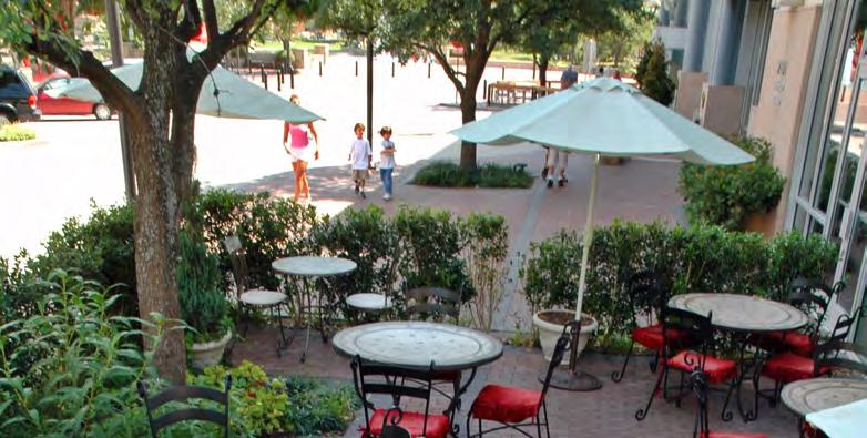
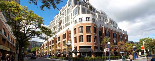
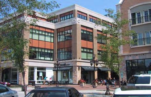
11 Winston Road Neighbourhood Urban Design Manual Town of Grimsby 2.2 DETAILED DISTRICT DESIGN CRITERIA The underlying concept inherent to the development of each district is based on providing an appropriate transition to existing land uses and Lake Ontario s waterfront by: Delivering strong visual and physical links to Lake Ontario. Future street and block patterns as well as building sittings are to enhance residents and visitors connection to the waterfront; Respecting the low-rise residential character in the west end of the neighbourhood with heights and densities gradually increasing towards the east sector surrounding the Casablanca Road interchange; and, Delivering high quality, comfortable, multi modal, and safe public and private streetscapes understanding the Winston Road Neighbourhood as an interconnected district to house one of the highest density growth zones in the Town of Grimsby. Below is a detailed description of each district s character. Winston Road Main Street District (Main Street Overlay Designation) Winston Main Street is to function as the primary pedestrian destination in the neighbourhood. Shops are envisioned to line the street on the ground floor while residential and/or office uses occupy the upper floors. The Vision for Winston Road Main Street is anchored on the delivery of five elements: A range of mixed uses with retail and/or service commercial at grade and residential and/or office uses above; A Village Square in association with retail suitable for community activities such as weekend markets; The careful design of the public right of way to include wide enough sidewalks, street trees, and on-street parking opportunities; The integration of the existing Casablanca Inn built form into the streetscape by maximizing the hotel s site frontage onto Winston Road; and, The public and private realm enhancement of district s gateway points located at Winston Road and Hunter Road and Winston Road and Windward Drive. Main Street precedence images. page 7


12 The Village by the Lake District (Mixed Use-High Density Land Use Designation) The Village by the Lake District is envisioned as a vibrant waterfront urban village featuring community facilities, in the form of a park and waterfront promenade, and a mix of residential and commercial development opportunities. The Vision for the Village by the Lake District is based on the delivery of the following key elements: The design and development of a neighbourhood with Lake Ontario as its focus. The district s building siting and open space placement strategy is to maximize the area s visual and physical connection to the lake; The introduction of a street and block pattern, to include a Waterfront Promenade Street and the use of identified view corridors, that maximizes the site s visual and physical connectivity to the waterfront by introducing mid-block connectors where blocks are longer than 250 metres; A Waterfront Promenade Street to include a multi use trail, lookout/rest areas, beaches and parks; A Waterfront Promenade Street with direct pedestrian access and frontages and no vehicular driveways; The development of high quality public and private roads throughout the district focused on delivering a Complete Street system; A range of residential typologies ranging from townhouse and staked townhouse units to low to high-rise apartment buildings; Commercial opportunities within mixed-use buildings along the district s Main Street frontage, Hunter Road, North Service Road and to a lesser extent internal to the district when appropriate and related to the waterfront recreational system; Employment opportunities along the North Service Road frontage west of Casablanca Boulevard; and, A carefully designed built form transition that addresses the water edge, adjacent open space, and specialty crop areas in a manner that is pedestrian scaled, provides eyes on the street and visually transitions from no development to development areas. Village by the Lake precedence images. Examples highlight building massing options that transition through gradual height changes to adjacent open spaces, waterfront areas and public streets. page 8 FEBRUARY 2016


13 Winston Road Neighbourhood Urban Design Manual Town of Grimsby South of Winston Road District: Hunter Road to Casablanca Boulevard (Mixed Use-High Density Land Use Designation) This District is envisioned to develop as a pedestrian oriented mixed-use district anchored on the delivery of the following key components: The design and development of a neighbourhood with Lake Ontario as its focus. The district s building siting and open space placement strategy is to maximize the area s visual and physical connection to the lake; The introduction of a street and block pattern that maximizes the site s visual and physical connectivity to the waterfront by introducing mid-block connectors where blocks are longer than 250 metres; The development of high quality public and private roads throughout the district focused on delivering a Complete Street system; A range of residential typologies ranging from townhouse and staked townhouse units to low to high-rise apartment buildings; Commercial opportunities within mixed-use buildings along the district s Main Street frontage; Employment opportunities along the QEW interface; and, A carefully designed built form transition that addresses the QEW and Casablanca Boulevard edge, and the transition from employment to mixed use residential buildings in a manner that is pedestrian scaled and provides eyes on the street. South of Winston Road District: Oakes to Hunter Road (Mixed Use-Medium Density Land Use Designation) This District is envisioned to develop as a pedestrian oriented mixed-use district anchored on the delivery of the following key components: The design and development of a neighbourhood with Lake Ontario as its focus. The district s building siting and open space placement strategy is to maximize the area s visual and physical connection to the lake; The introduction of a street and block pattern that maximizes the site s visual and physical connectivity to the waterfront by introducing mid-block connectors where blocks are longer than 250 metres; The development of high quality public and private roads throughout the district focused on delivering a Complete Street system; A range of residential typologies ranging from townhouse and staked townhouse units to low-rise to mid-rise apartment buildings; Commercial opportunities within mixed-use buildings along the district s QEW inter phase; A carefully designed north-south built form transition that addresses the rapid shift from a highway condition along North Service Road to an open space condition along Winston Road in less than 170 metres; and, A carefully designed east west built form transition that addresses the shift from low to the west to high mixed use density forms to the east. South of Winston Road precedence images. Examples highlight building massing options that create a mixed use pedestrian friendly environment. page 9
14 3. Urban Design Manual Good urban design practices promote excellence in community design. With this in mind, the Winston Road Neighbourhood Design Manual objective is to: Create distinctive and appealing streetscapes through attention to building design and detailing; Ensure building s appropriate massing, materials and siting; Ensure design compatibility; Identify specific design requirements for buildings located on highly visibly priority areas such as gateways and along the waterfront; Encourage pedestrian friendly streetscapes; and, Ensure the community is universally accessible as per the Design of Public Spaces Standard O. Reg. 413/12 and Ontario Regulation 368/13 (O. Reg. 368/13) which amends the Ontario Building Code, 2012 (O. Reg. 332/12). The Winston Road Neighbourhood Design Manual has been divided into two sections that detail specific design criteria related to: 1. Built Form Typologies Standards 1a. Low Rise Townhouse Forms 1b. Low Rise Mixed Use and Apartment Building Forms 1c. Mid to High Rise Mixed Use and Apartment Building Forms 1d. Low to Mid Rise Mixed Use and Office Building Forms 2. Site Planning Standards 2a. Block design 2b. Streetscapes 2c. Open Space 2d. Miscellaneous Site Planning and Built Form Design Elements Each section has been setup as a checklist to facilitate the builder and design reviewer review of project. All built form typologies are subject to the Town s 2015 Zoning by-law. Alternatives which are consistent with the intent or objective of this Urban Design Manual criteria will be considered, on a case by case basis, as site specific constraints might impact a site s ability to incorporate all of this manual s recommended design criteria, provided the proposed development has regards for and delivers on the Winston Road OP and West End Waterfront Trail and Neighbourhood Master Plan vision. page 10 FEBRUARY 2016


15 Winston Road Neighbourhood Urban Design Manual Town of Grimsby Built Form Typologies Standards: Low-Rise Buildings Townhouse Forms 2-3 storeys in height Description A building comprised of four or more attached residential dwelling units arranged side by side or on top of each other. The dwelling units may also be configured for live-work occupancy in which case, the non-residential use is located on the ground floor. Live-work configurations provide for separate non-residential and residential entries from the sidewalk with the combination of workspace and residential dwelling typically being owned or leased by the same person(s). Parking and garage areas can be provided through front or rear (lane-based) configurations. Townhouse forms described in this manual include back-to-back, stacked, block and street townhouse forms as per the Town of Grimsby 2015 Zoning By-law definitions. YES NO N/A COMMENTS Section 1.0 BUILT FORM GUIDELINES 1.1 Building Placement New development shall comply with all building regulations contained in the Town of Grimsby 2015 Zoning By-law. New development located at the end of streets, should align design features, such as entries and porticos to the view axis 1.2 Garage Placement Rear accessed Detached Garages Townhouses with reduced frontages should have rear-accessed garages in order to: Ensure that the front entry and habitable ground floor space, rather than garages, are the dominant features of front facades; Provide adequate space for front yard landscaping and street trees; page 11 Provide adequate space for incorporation of utility meters and mechanical equipment; and, Built Form Typology: Low -Rise Townhouse Built Forms
16 YES NO N/A COMMENTS Provide sufficient on-street parking in front of the units. Rear accessed detached garages should be located in a rear yard or interior yard only. Where possible, garages are paired to allow for increased rear yard, or outdoor amenity space. Driveways should be designed to reduce the amount of asphalt. Rear accessed Attached Garages Rear accessed attached garages, which are deemed to be part of the main building on the lot, are permitted provided that the garage facing the public lane or private road: Is paired, where possible, to allow for increased rear yard, or outdoor amenity space. Driveways are designed to reduce the amount of asphalt. Front accessed Attached Garages Where garages are located in the front of a unit, garages should be paired to allow for more substantial front yard green space. Garages shall not protrude beyond the main front wall of the dwelling unit. 1.3 Building Size, Articulation, and Massing Buildings are composed of two to three storeys in compliance with the Town of Grimsby Zoning By-law Units adjacent to the waterfront s Promenade Street with direct views of Lake Ontario, as well as Hunter Road and Winston Road s Main Street are given special consideration in architectural design, massing, orientation, sitting and materials by: Orientating their primary entrances to the primary street with direct universal access to the sidewalk. The entries are articulated through the use of entry features such as projecting porches, porticos or verandas; Locating garages and driveways on the local road system, off the primary street; and, Highly articulating the unit s front and corner facades through the use of coordinated fenestration, masonry detailing, accent gables, dormers, and/or other special treatment. page 12 FEBRUARY 2016 Built Form Typology: Low -Rise Townhouse Built Forms
17 Winston Road Neighbourhood Urban Design Manual Town of Grimsby Buildings located adjacent to, or at the edge of parks or urban squares provide opportunities for overlook into the public space with windows and doors. The massing, siting and scale of these buildings should create a degree of enclosure or definition appropriate to the type of open space they enclose. YES NO N/A COMMENTS Buildings sited next to the identified 30-metre view corridors frame the corridors and do not block the identified view. Encroachment into the front and exterior side setbacks such as unenclosed porches, bay windows, stairs, canopies and other features is encouraged to add visual interest along the streetscape. The elevation of the townhouse block provides for variations between units while reinforcing the common characteristics of the block. A variety of architectural elements such as entry porch, dormers, material detailing are employed to create a distinctive character for each block. Corner units are designed with side façade elevation of equal architectural expression and similar façade materials consistent with those used on front elevations. Corner units use architectural elements as well as distinctive building entrance features to emphasize their visual prominence. Buildings along the same street are of a consistent building mass and height to provide for a consistent pedestrian scale. The soffits have a consistent minimum overhang. When possible, all stacks and vents are to be located as to not be visible from the front in the case of a corner lot, and are located on the rear slope of the roof and coordinated with roof colour. When this is not possible, as in the case of back-to-back units, stacks and vents shall be coordinated with the roof and façade material colour. A variety of roof configurations is present including accent gables, dormers, porches and roof ridges both parallel and perpendicular to the street. To provide visual interest and variety, different roof slopes are used. In all instances the roofline should compliment the building s architectural style. For habitable spaces within a pitched roof, dormer windows are used to articulate the roof profile and provide natural light. page 13 Built Form Typology: Low -Rise Townhouse Built Forms
18 YES NO N/A COMMENTS 1.4 Frontage Front yard transition from public to private, indoor to outdoor, at the entrance to each building is demarcated by an unenclosed portico, porch or veranda. Most units are designed to incorporate a porch. A minimum of 50% of the units includes an option for a portico or covered unenclosed porch. Porticos, porches and verandas are not enclosed. Porches are permitted to encroach into the front and exterior side yard. Wrap around porches and/or verandas are encouraged on corner units. Porches are designed to be functional and useable. They are deep enough to allow for a seating area with a minimum depth of 1.5 metres. Where possible, the porch width encompasses the entry door and windows on the front facade of the unit. Front porches are a maximum of 3.05 metres (10 feet) from finished porch level to bottom of soffit, and are constructed of materials utilized throughout the development. This does not preclude the construction of second level terraces or building over the porch. A front entry with more than five risers leading to the porch is discouraged. Where five risers are exceeded, the front entry design includes elements to minimize the prominence of exposed basement walls and stairs, including appropriately detailed elevation treatments, railing, integration of steps into the design of the porch and designing the steps in concert with the landscape. Wood steps are not used. Single entry doors incorporate sidelights and/or transoms. Where these are not possible due to floor plan arrangement, a vision panel (glazing) is provided in the entry door. Sliding doors are not used on front or flankage elevations as primary entrances into a dwelling. Windows on front and flankage elevations have a vertical emphasis. Architectural details are used to emphasize doors and windows. 1.5 Pedestrian Access The unit s principal entrance(s), residential and retail in the case of live-work units, faces the sidewalk and provides direct access onto the sidewalk. page 14 FEBRUARY 2016 Built Form Typology: Low -Rise Townhouse Built Forms
19 Winston Road Neighbourhood Urban Design Manual Town of Grimsby Mid block pedestrian connections are provided on blocks larger than 120 metres in length. Pedestrian connections have a minimum of 6.0 in width. YES NO N/A COMMENTS Mid-block pedestrian connections are easy to find, clearly visible, safe and have direct and universal access to the public sidewalk. Windows frame mid-block pedestrian connections providing for a safer pedestrian environment. Privacy fencing along mid-bloc connectors is limited to rear yard portions only. 1.6 Amenity Area Outdoor amenity areas are provided in a variety of forms including verandas, rear yards, rear deck above garage, roof-top deck, balconies or a design of similar intent. For townhouse dwellings with an attached garage in the rear, a minimum of one (1) outdoor amenity area requirement may be considered rather than a rear yard setback. Such amenity area may include outdoor space on a second floor or roof top deck. For back-to-back townhouse dwellings, a minimum outdoor amenity area requirement may be considered to include outdoor space on a second floor balcony or a roof top deck. 1.7 Utilities and Mechanical Equipment Utilities are incorporated into architectural elements, the walls of recessed entries, and the change of building face setback between units and recessed wherever technically possible. Air conditioning units and dryer vents, if not screened, are not located on any elevation facing the street or primary frontage. 1.8 Landscaping Front and side yard landscaping areas are provided to enhance the overall streetscape quality and promoting the walkability of the neighbourhood. Private property landscaping at corners includes enhanced vegetation features and/or coordinated decorative fencing to frame the road intersections. Main Street front and side yards are hardscaped as an extension of the sidewalk to provide for outdoor café and/or additional sitting opportunities. page 15 Built Form Typology: Low -Rise Townhouse Built Forms
20 YES NO N/A COMMENTS Low maintenance and drought resistant landscaping is proposed. Where appropriate, decorative fencing is used along the public realm as a coordinated design feature of the entire townhouse block. The decorative fence design offers a level of transparency as a primarily open structure, not a solid wall, to help define the separation between private and public property. Privacy fences are encouraged to be located along rear yard, outdoor amenity areas only. 1.9 Sustainability The development applies at least one (1) of the following strategies to reduce water consumption (as per Niagara s Region Smart Growth design criteria): Use of drought-tolerant native species; Use of captured rainwater; Use of recycled water; Use of other non-potable water sources such as stormwater; Use of air-conditioning condensate; and, Use of foundation drain water. Additional Comments page 16 FEBRUARY 2016 Built Form Typology: Low -Rise Townhouse Built Forms


21 Winston Road Neighbourhood Urban Design Manual Town of Grimsby Built Form Typologies Standards: Low-Rise Buildings Mixed Use & Apartments Buildings 2-4 storeys in height. Description A building designed for occupancy by retail and/or service uses on the ground floor with upper floors configured for office and/or residential uses. Upper floors might be directly accessed from the street through a stair or through a street level lobby. The building may also be configured for residential occupancy only. Single use buildings can be located with all districts while mixed-use buildings are specially envisioned for the Main Street district area. Section 1.0 BUILT FORM GUIDELINES YES NO N/A COMMENTS 1.1 Building Placement New development shall comply with all building regulations contained in the Town of Grimsby 2015 Zoning By-law. Buildings are sited parallel to the street along their main frontage oriented to address the primary frontage. A building wall occupies as a minimum 80% of a site s main frontage. Buildings located adjacent to, or at the edge of parks or urban squares provide opportunities for overlook into the public space with windows and/ or doors. The massing, siting and scale of these buildings create a degree of enclosure or definition appropriate to the type of open space they enclose while providing eyes on the street. Buildings sited next to the identified 30.0 metre view corridors frame the corridors and under no circumstance block the identified view. New development located at the end of streets, should align design features, such as entries and porticos to the view axis. page 17 Built Form Typology: Low -Rise Mixed Use & Apartment Built Forms
22 YES NO N/A COMMENTS Gateway buildings (i.e. Winston Road at Hunter Road and Winston Road at Windward Drive) use tall architectural elements, different roof configurations and/or distinctive building entrance features, such as covered unenclosed porches, to emphasize their visual prominence. 1.2 Building Size, Articulation and Massing Buildings are composed of two to four storeys. Corner buildings are designed with side façade elevation of equal architectural expression and similar façade materials consistent with those used on front elevations. Buildings along the same street compliment each other s building mass and height providing for a consistent pedestrian scale and an inviting pedestrian realm. Facades are articulated through a vertical change in plane or increments of no more than 10 metres. Increments are created through projecting or recessing wall surfaces, changes in roofline and/or placement of building piers, columns, and pilasters. New development is compatible with adjacent and neighbouring built forms by ensuring that the siting and massing of new buildings does not result in undue adverse impacts on adjacent properties particularly in regard to adequate sun light exposure as well as privacy conditions for residential buildings and their outdoor amenity areas. Mixed use buildings located along Winston Road s Main Street should be designed in a manner that highlights main street s typical storefront characteristics of articulated retail facades, recessed windows, and distinctive storefronts. When used, vertical framing elements, such as building piers, columns and pilasters, appear as structural elements for the upper floors. In addition to vertical articulation, facades are designed through a change in horizontal planes that clearly distinguish the base, middle and top of the building. Horizontal change in plane is created through step backs, extrusions, textures and materials. Buildings sited next to the identified view corridors have a 3.0 metre step back for floors above the third storey to enhance views. Buildings do not exceed 90.0 metres in length. page 18 FEBRUARY 2016 Built Form Typology: Low -Rise Mixed Use & Apartment Built Forms
23 Winston Road Neighbourhood Urban Design Manual Town of Grimsby Ground related retail and service commercial uses have a minimum 4.5 metre floor to ceiling height. When a 4.5 metre floor to ceiling height cannot be achieved the builder should provide an alternate strategy to accommodate for potential food related businesses. YES NO N/A COMMENTS A variety of roof configurations is used consisted with the building s architectural style. 1.3 Frontage Active retail space, rather than service rooms are oriented towards the street and pedestrian walks to rear parking areas or mid block connectors. Non-residential front and side facades are designed with a combination of main street storefront elements, including display windows, window bases or kick plates, transom windows, and storefront cornices A minimum 70% and maximum of 90% transparency is delivered for all ground related retail and service commercial uses to allow eyes on the street. A minimum of 15% and maximum of 70% transparency is delivered for each ground or upper residential floor to allow eyes on the street. Clear vision glass is utilized for all ground floor non-residential uses. Individual residential entries located on facades other than the where the non-residential entries are located, are designed with distinctive entry features such as covered front porticos and porches as follows: page 19 Porticos, porches and verandas are not enclosed. Porticos encroach into the front and exterior side yards. Wrap around porches and/or verandas are encouraged in corner units. Porches are functional and useable. They are deep enough to allow for a seating area with a minimum depth of 1.5 metres. Where possible, the porch width encompasses the entry door and windows on the front facade of the unit. Front porches have a maximum of 3.05 metres (10 feet) from finished porch level to bottom of soffit, and are constructed of materials utilized throughout the development. This does not preclude the construction of second level terraces or building over the porch. Built Form Typology: Low -Rise Mixed Use & Apartment Built Forms
24 YES NO N/A COMMENTS A front entry with more than five risers leading to the porch is avoided. Where five risers are exceeded, the front entry design includes elements to minimize the prominence of exposed basement walls and stairs, including appropriately detailed elevation treatments, railing, integration of steps into the design of the porch and designing the steps in concert with the landscape. Wood steps are not used. Single entry doors incorporate sidelights and/or transoms. Where these are not possible due to floor plan arrangement, a vision panel (glazing) is provided in the entry door. Shared apartment entrances are located and oriented to the street, and designed to be visible and universally accessible to residents and visitors alike. Shared apartment entrances are easily differentiated from other ground related entrances by the use of recessed entrances, change in façade materials and colours and/or the provision of weather protection elements such as awnings or canopies. Sliding doors are not used on front or flankage elevations as primary entrances into a dwelling. Windows on front and flankage elevations have a vertical emphasis.. Architectural details are used to emphasize doors and windows. 1.4 Pedestrian Access The principal entrances to retail and service commercial uses face the sidewalk and provide direct and universal access onto the public sidewalk. Steps and ramps are architecturally incorporated into the building entrance. Access to individual ground related residential units principal entrances are provided at street level accessed directly from the street. Access to upper storeys is provided through a street level universally accessible lobby and/or corridors and stairs accessed directly from the street. Corner entrances, whenever possible, address both sides of the street. page 20 FEBRUARY 2016 Built Form Typology: Low -Rise Mixed Use & Apartment Built Forms
25 Winston Road Neighbourhood Urban Design Manual Town of Grimsby Mid block pedestrian connections have a minimum width of 6.0 metres, and are provided on blocks larger than metres in length or between two buildings and rear parking areas or adjacent sites. YES NO N/A COMMENTS Windows and/or entrances frame mid-block pedestrian connections providing for a safer pedestrian environment. Mid block pedestrian connections are easy to find, clearly visible and have direct and universal access to the public sidewalk. 1.5 Vehicular Access, Parking, Utilities and Servicing Outdoor bicycle racks are located in a highly visible, easily accessible, and well-lit location, ideally in close proximity to primary entrances. Vehicular access is provided through a rear lane where available. Where access through a rear lane is not available, vehicle access is provided through a driveway located on one side of the building directing traffic towards the back of the building. Parking is provided in a rear and/or side surface lot area, parking structure, underground parking, carport or a combination of any of the above. No parking, driveways or laneways are located between the building main façade and the street(s). When present, entrances to the site s underground parking is located to the side or rear of the lot. When present, drop-off access is provided off from rear lanes or secondary roads. Services, including garbage areas and containers as well as loading areas are located along a rear lane or rear and/or internal side yards when a rear lane is not present. Services, including garbage areas and containers, including decorative bins, as well as loading areas are located along a rear lane or rear and/or internal side yards when a rear lane is not present. Utilities are within the building, when feasible or in other locations, which are screened from public view. Rooftop mechanical equipment is screened from view through architectural design that reflects the building s façade treatment. Add-on screening elements such as lattice are not used. page 21 Built Form Typology: Low -Rise Mixed Use & Apartment Built Forms
26 YES NO N/A COMMENTS 1.6 Outside Storage No outside storage is present. 1.7 Amenity Area Private amenity areas, servicing upper floor office or residential land uses are provided in a variety of forms including verandas, rear deck above garage, rooftop deck, or balconies. Public amenity areas, complimenting ground floor retail are provided as front, side or rear outdoor cafes, patios, display, or siting areas, and do not encroach onto the street s sidewalk. 1.8 Landscaping Main Street front and side yards are hardscaped as an extension of the sidewalk to provide for outdoor café and/or additional sitting opportunities. Private property landscaping at corners includes enhanced vegetation features to frame the road intersection. For all other front and side yards, low maintenance and drought resistant landscaping is used. 1.9 Sustainability To conserve energy and resources and reduce greenhouse emissions, the development incorporates one (1) of the following features (as per Niagara s Region Smart Growth design criteria): Garden roofs/green roofs; Use high-albedo materials; Open grid paving for ground treatment; Energy is generated on site from renewable energy sources (i.e. wind, solar, geothermal or through co-generation); and, Other suitable methods as proved by the Town and Region. The development applies at least one (1) of the following strategies to reduce water consumption (as per Niagara s Region Smart Growth design criteria): Use of drought-tolerant native species; Use of captured rainwater; Use of recycled water; page 22 FEBRUARY 2016 Built Form Typology: Low -Rise Mixed Use & Apartment Built Forms
27 Winston Road Neighbourhood Urban Design Manual Town of Grimsby Use of other non-potable water sources such as stormwater; Use of air-conditioning condensate; and, Use of foundation drain water. YES NO N/A COMMENTS Additional Comments page 23
28 This page has been left intentionally blank. page 24 FEBRUARY 2016


29 Winston Road Neighbourhood Urban Design Manual Town of Grimsby Built Form Typologies Standards: Mid to High Rise Buildings Mixed Use Residential & Residential Buildings 4- storeys and above in height. Description A building designed for occupancy by retail and/or service uses on the ground floor with upper floors configured for office and/or residential uses, or a building designed for residential uses only. When ground related retail and/or service uses are present, upper floors might be directly accessed from the street through a street level lobby. This building type can be constructed within medium and high-density mixed-use zones provided buildings located within medium density mixed use zones have a maximum height of 6 storeys and buildings located within medium density use zones have a maximum height of 12 storeys as per Official Plan policies. YES NO N/A COMMENTS Section 1.0 BUILT FORM GUIDELINES 1.1 Building Placement New development shall comply with all building regulations contained in the Town of Grimsby 2015 Zoning By-law. Buildings are sited parallel to the street along their main frontage. Buildings occupy a minimum of 80% of a site s main frontage. Buildings located adjacent to, or at the edge of parks or urban squares provide opportunities for overlook into the public space with windows and/ or doors. The massing, siting and scale of these buildings create a degree of enclosure or definition appropriate to the type of open space they enclose while providing eyes on the street. Buildings sited next to the identified 30.0 metre view corridors frame the corridors and under no circumstance block the identified view. New development located at the end of streets, should align design features, such as entries and porticos to the view axis. page 25 Built Form Typology: Mid-High Rise Mixed Use & Apartment Built Forms
30 Gateway buildings (i.e. Winston Road at Hunter Road and Winston Road at Windward Drive) use tall architectural elements, different roof configurations and/or distinctive building entrance features, such as covered unenclosed porches, to emphasize their visual prominence. YES NO N/A COMMENTS 1.2 Building Size, Articulation, and Massing Buildings on corner lots are designed with two facades of equal architectural expression. Buildings along the same street compliment each other s building mass and height providing for a consistent pedestrian scale and an inviting pedestrian realm. New development shall be compatible with adjacent and neighbouring built form by ensuring that the siting and massing of new buildings does not result in undue adverse impacts on adjacent properties particularly in regard to adequate sun light exposure as well as privacy conditions for residential buildings and their outdoor amenity areas. Facades are articulated through a vertical change in plane or increments of no more than 10 metres. Increments are created through projecting or recessing wall surfaces, changes in roofline and/or placement of building piers, columns, and pilasters. Mixed use buildings located along Winston Road s Main Street should be designed in a manner that highlights a main street typical storefront characteristics of articulated retail facades, recessed windows, and distinctive storefronts. When used, vertical framing elements, such as building piers, columns and pilasters, appear as structural elements for the upper floors. In addition to vertical articulation, facades are designed through a change in horizontal planes that clearly distinguish the base, middle and top of a building. Horizontal change in plane is created through step backs, extrusions, textures and materials. Buildings provide a step back of 3.0 metres for all levels above and no less than the 3rd storey. Front facades are subject to a front angular plane performance standard of 45-degree angle from the property line, beginning at a height of 80 percent of the width of the adjacent right of way. Rear facades are subject to a rear angular plane performance standard of 45-degree angle 7.5 metres from the rear property line. page 26 FEBRUARY 2016 Built Form Typology: Mid-High Rise Mixed Use & Apartment Built Forms
31 Winston Road Neighbourhood Urban Design Manual Town of Grimsby YES NO N/A COMMENTS Ground related retail and service commercial uses have a minimum 4.5 metre floor to ceiling height. When a 4.5 metre floor to ceiling height cannot be achieved the builder should provide an alternate strategy to accommodate for potential food related businesses. Rooftop mechanical equipment is screened with materials that are complementary to the building. 1.3 Frontage Active spaces, rather than service rooms are oriented towards the street and pedestrian walks to rear parking areas or mid block connectors. Retail facades are designed with a combination of main street storefront elements, including display windows, window bases or kickplates, transom windows, and storefront cornices. A minimum 70% and maximum of 90% transparency is delivered for all ground related retail and service commercial uses to allow eyes on the street. A minimum of 15% and maximum of 70% transparency is delivered for each ground or upper residential floor to allow eyes on the street. Clear vision glass is utilized for all ground floor non-residential uses. Individual residential entries located on facades other than the where the non-residential entries are located, are designed with distinctive entry features to include a combination of the following features: Provision of weather protection elements such as awnings, porticos, and not enclosed porches or verandas; Wrap around porches and/or verandas are encouraged at corners; Front landscaped courtyards that clearly demarcate private from public property; When present, porches are designed to be functional and useable. They are deep enough to allow for a seating area with a minimum depth of 1.5 metres. Where possible, the porch width encompasses the entry door and windows on the front facade of the unit; Front porches have a maximum of 3.05 metres (10 feet) from finished porch level to bottom of soffit, and are constructed of materials utilized throughout the development; page 27 Built Form Typology: Mid-High Rise Mixed Use & Apartment Built Forms
32 YES NO N/A COMMENTS Single entry doors incorporate sidelights and/or transoms. Where these are not possible due to floor plan arrangement, a vision panel (glazing) is provided in the entry door; and, Above grade sliding doors are not used on front or flankage elevations as primary entrances into a dwelling. Shared apartment entrances are located and oriented to the street, and designed to be visible and universally accessible to residents and visitors alike. Shared apartment entrances are easily differentiated from other ground related entrances by the use of recessed entrances, change in façade materials and colours and/or the provision of weather protection elements such as awnings or canopies. Windows on front and flankage elevations have a vertical emphasis. Architectural details are used to emphasize doors and windows. 1.4 Pedestrian Access The principal entrances to retail and service commercial uses face the sidewalk and provide direct and universal access onto the public sidewalk. Steps and ramps are architecturally incorporated into the building entrance. Access to individual ground related residential units principal entrances is provided at street level accessed directly from the street. Access to upper storeys is provided through a street level universally accessible lobby and/or corridors and stairs accessed directly from the street. Corner entrances are used whenever possible, to give address to both street frontages. Mid block pedestrian connections, with a minimum width of 6.0 metres, are provided on blocks larger than metres in length or in between two buildings and rear parking areas or adjacent sites. Windows and/or entrances frame mid-block pedestrian connections providing for a safer pedestrian environment. Mid block pedestrian connections are easy to find, clearly visible, safe and have direct and universal access to the public sidewalk. page 28 FEBRUARY 2016 Built Form Typology: Mid-High Rise Mixed Use & Apartment Built Forms
33 Winston Road Neighbourhood Urban Design Manual Town of Grimsby YES NO N/A COMMENTS 1.5 Vehicular Access, Parking, Utilities and Service Outdoor bicycle racks are located in a highly visible, easily accessible, and well-lit location, in close proximity to primary entrances. Vehicular access is provided through a rear lane where available. Where access through a rear lane is not available, vehicle access is provided through a driveway located on one side of the building directing traffic towards the back of the building. Parking is provided in a rear and/or side surface lot area, parking structure, underground parking, carport or a combination of any of the above. No parking, driveways or laneways is located between the building and the street(s). When present, entrances to the site s underground parking are located to the side or rear of the lot. When present, drop-off access is provided off rear lanes or secondary roads. Services, including garbage areas and containers, including decorative bins, as well as loading areas are screened from view from the street, public open spaces and adjacent residential areas. Services, including garbage areas and containers as well as loading areas are screened from view from the street, public open spaces and adjacent residential areas. Utilities are located within the building, when feasible or in other locations, which are screened from public view. Concealed interior above ground parking structures are present provided the following design requirements are followed: The structure is lined by at least 10.0 metres in depth and the same height as the proposed parking structure of active retail/service commercial and/or office and residential uses on all primary street frontages with the exception of lanes and other service drives; Above ground parking structures are no more than four storeys in height equal to the base or podium element of a building; The uppermost story of a parking garage includes a decorative parapet to provide visual interest and to diminish the view of parked vehicles; and, page 29 Built Form Typology: Mid-High Rise Mixed Use & Apartment Built Forms
34 YES NO N/A COMMENTS Portions of the uppermost parking storey not covered by the building s middle and top elements are used for building amenity purposes and all parking components are covered and blocked from upper floors views. 1.6 Outside Storage No outside storage is permitted. 1.7 Amenity Area Private amenity areas, servicing upper floor office or residential land uses are provided in a variety of forms including verandas, rooftop decks, or balconies. Public amenity areas, complimenting ground floor retail uses are provided as front, side or rear outdoor cafes, patios, display, or siting areas, and do not encroach into the street s sidewalk. Private communal open space should be designed to provide a range of recreational opportunities, which may include plazas, children s pay equipment, landscaped gardens, tennis courts, etc. Pedestrian-scales lighting must be provided in all open space areas. Spaces between structures not occupied by permitted access drives or paved pedestrian routes should be landscaped as usable open space and accessible to pedestrians. 1.8 Landscaping Front and side yard landscaping areas are provided to enhance the overall streetscape quality and promoting the walkability of the neighbourhood. Main Street front and side yards are hardscaped as an extension of the sidewalk to provide for outdoor café and/or additional sitting opportunities. Private property landscaping at corners includes enhanced vegetation features to frame the road intersections. For all yards, low maintenance and drought resistant landscaping is used. 1.9 Sustainability To conserve energy and resources and reduce greenhouse emissions, the development page 30 FEBRUARY 2016 Built Form Typology: Mid-High Rise Mixed Use & Apartment Built Forms
35 Winston Road Neighbourhood Urban Design Manual Town of Grimsby incorporates one (1) of the following features (as per Niagara s Region Smart Growth design criteria): Garden roofs/green roofs; Use high-albedo materials; Open grid paving for ground treatment; Energy is generated on site from renewable energy sources (i.e. wind, solar, geothermal or through co-generation); and, Other suitable methods as proved by the Town and Region. YES NO N/A COMMENTS The development applies at least one (1) of the following strategies to reduce water consumption (as per Niagara s Region Smart Growth design criteria): Use of drought-tolerant native species; Use of captured rainwater; Use of recycled water; Use of other non-potable water sources such as stormwater; Use of air-conditioning condensate; and, Use of foundation drain water. Additional Comments page 31 Built Form Typology: Mid-High Rise Mixed Use & Apartment Built Forms
36 This page has been left intentionally blank. page 32 FEBRUARY 2016


37 Winston Road Neighbourhood Urban Design Manual Town of Grimsby Built Form Typologies Standards: Low to Mid Rise Buildings Mixed Use & Office Buildings 4-8 storeys in height. Description A building designed for occupancy by retail and/or service uses on the ground floor with upper floors configured for office uses, or a building designed for office uses only. When ground related retail and/or service uses are present, upper floors might be directly accessed from the street through a street level lobby. This building type can be constructed within the high-density mixed-use zone. Section 1.0 BUILT FORM GUIDELINES 1.1 Building Placement YES NO N/A COMMENTS New development shall comply with all building regulations contained in the Town of Grimsby 2015 Zoning By-law. Buildings are sited parallel to the street along their main frontage. Buildings occupy a minimum of 80% of a site s main frontage. Buildings located adjacent to, or at the edge of parks or urban squares provide opportunities for overlook into the public space with windows and/ or doors. The massing, siting and scale of these buildings create a degree of enclosure or definition appropriate to the type of open space they enclose while providing eyes on the street. Buildings sited next to the identified 30-metre view corridors frame the corridors and under no circumstance block the identified view. New development located at the end of streets, should align design features, such as entries and porticos to the view axis. Gateway buildings use tall architectural elements as well as distinctive building entrance features to emphasize their visual prominence. page 33 Built Form Typology: Low to Mid -Rise Mixed Use & Office Built Forms
38 YES NO N/A COMMENTS 1.2 Building Size, Articulation, and Massing Buildings are composed of four to eight storeys. Buildings on corner lots are designed with two facades of equal architectural expression. Buildings along the same street compliment each other s building mass and height providing for a consistent pedestrian scale and an inviting pedestrian realm. New development is compatible with adjacent and neighbouring built form by ensuring that the siting and massing of new buildings does not result in undue adverse impacts on adjacent properties particularly in regard to adequate sun light exposure as well as privacy conditions for residential buildings and their outdoor amenity areas. Buildings do not exceed 90.0 metres in length. Facades are articulated through a vertical change in plane or increments of no more than 20.0 metres. Increments are created through projecting or recessing wall surfaces, changes in roofline and/or placement of building piers, columns, and pilasters. When used, vertical framing elements, such as building piers, columns and pilasters, appear as structural elements for the upper floors. In addition to vertical articulation, facades are designed through a change in horizontal planes that clearly distinguish the base, middle and top of a building. Horizontal change in plane is created through step backs, extrusions, textures and materials. Buildings provide a step back of 3.0 metres for all levels above and no less than the 3rd storey. Front facades of buildings over four storeys in height are subject to a front angular plane performance standard of 45 degree angle from the property line, beginning at a height of 80 percent of the width of the adjacent right of way. Rear facades of buildings over four storeys in height are subject to an angular plane performance standard of 45-degree angle 7.5 metres from the rear property line. Ground related retail and service commercial uses have a minimum 4.5 metre floor to ceiling height. When a 4.5 metre floor to ceiling height cannot be achieved the builder should provide an alternate strategy to accommodate for potential food related businesses. page 34 FEBRUARY 2016 Built Form Typology: Low to Mid -Rise Mixed Use & Office Built Forms
39 Winston Road Neighbourhood Urban Design Manual Town of Grimsby Rooftop mechanical equipment is screened with materials that are complementary to the building. YES NO N/A COMMENTS 1.3 Frontage Active spaces, rather than service rooms are oriented towards the street and pedestrian walks to rear parking areas or mid block connectors. A minimum 70% and maximum of 90% transparency is used for floors to allow eyes on the street. Clear vision glass is utilized at ground level. Office building entrances are easily recognizable with a high degree of façade articulation. Primary entrances use a combination of recessed entrances, change in façade materials and colours and/or the provision of weather protection elements such as awnings or canopies. 1.4 Pedestrian Access The principal entrances to retail and service commercial uses face the sidewalk and provide direct and universal access onto the public sidewalk. Steps and ramps are architecturally incorporated into the building entrance. Access to upper storeys shall are provided through a street level universally accessible lobby and/ or corridors and stairs accessed directly from the street. Corner entrances are used whenever possible, to give address to both street frontages. Mid block pedestrian connections, with a minimum width of 6.0 metres, are provided on blocks larger than metres in length or in between two buildings and rear parking areas or adjacent sites. Windows and/or entrances frame mid-block pedestrian connections providing for a safer pedestrian environment. Mid block pedestrian connections are easy to find, clearly visible, safe and have direct and universal access to the public sidewalk. Clear vision glass is utilized for all ground floor uses. page 35 Built Form Typology: Low to Mid -Rise Mixed Use & Office Built Forms
40 YES NO N/A COMMENTS 1.5 Vehicular Access, Parking, Utilities and Service Outdoor bicycle racks are located in a highly visible, easily accessible, and well-lit location, in close proximity to primary entrances. Vehicular access is provided through a rear lane where available. Where access through a rear lane is not available, vehicle access is provided through a driveway located one side of the building directing traffic towards the back of the building. Parking is provided in a rear and/or side surface lot area, parking structure, underground parking, carport or a combination of any of the above. No parking, driveways or laneways is located between the building and the street(s). When present, entrances to the site s underground parking are located to the side or rear of the lot. When present, drop-off access is provided off rear lanes or secondary roads. Parking and loading areas visible from the QEW and North Service Road are screened and buffered. Services, including garbage areas and containers as well as loading areas are located along a rear lane or rear and/or internal side yards when a rear lane is not present. Services, including garbage areas and containers as well as loading areas are screened from view from the street, public open spaces and adjacent residential areas. Utilities are located within the building, when feasible or in other locations, which are screened from public view. 1.6 Outside Storage No outside storage is permitted. 1.7 Amenity Area Outdoor private amenity areas, servicing office uses are provided in a variety of forms including roof top balconies or ground related landscaped patios and greens. page 36 FEBRUARY 2016 Built Form Typology: Low to Mid -Rise Mixed Use & Office Built Forms
41 Winston Road Neighbourhood Urban Design Manual Town of Grimsby YES NO N/A COMMENTS 1.8 Landscaping Landscaping areas are provided to enhance the overall streetscape quality and promoting the walkability of the neighbourhood. Privacy fencing and planting buffers are limited to rear yards adjacent to mixed use residential areas. Private property landscaping at corners includes enhanced vegetation features to frame road intersections. For all yards, a combination of low maintenance, drought resistant landscaping is used. 1.9 Sustainability To conserve energy and resources and reduce greenhouse emissions, the development incorporates one (1) of the following features (as per Niagara s Region Smart Growth design criteria): Garden roofs/green roofs; Use high-albedo materials; Open grid paving for ground treatment; Energy is generated on site from renewable energy sources (i.e. wind, solar, geothermal or through co-generation); and, Other suitable methods as proved by the Town and Region. The development applies at least one (1) of the following strategies to reduce water consumption (as per Niagara s Region Smart Growth design criteria): Use of drought-tolerant native species; Use of captured rainwater; Use of recycled water; Use of other non-potable water sources such as stormwater; Use of air-conditioning condensate; and, Use of foundation drain water. page 37 Built Form Typology: Low to Mid -Rise Mixed Use & Office Built Forms
42 Additional Comments page 38 FEBRUARY 2016


43 Winston Road Winston Road Neighbourhood Urban Design Manual Town of Grimsby Site Planning Standards: Block Design Hunter Road Grid Road System Mid-Block Pedestrian Connectors North Service Road Queen Elizabeth Way Windward Drive Casablanca Boulevard Description The Winston Road Neighbourhood block design criteria is meant to deliver a high degree of permeability and connectivity which directs pedestrian out to the surrounding roads through a fine grid of local streets and frequent local street connections. YES NO N/A COMMENTS Block lengths are generally a maximum of 250 metres in lenght to promote walkability. Blocks longer than 250 metres may be considered on an individual basis where other block alternatives are not feasible. In such cases, publicly accessible pedestrian mid-block connectors are provided. Where rear lanes are used, the maximum lane length is no more than metres in order to provide for a maximum 90.0m hose length from fire hydrants located on road connections. Where the metre length is exceeded, an on-street hydrant location and fire hose access to the rear lane is provided. Buildings in a block front onto a public open space provided the rear lot line adjoins and has access from a rear lane. Rear lanes are encouraged in mixed-use areas at rear of street-related buildings for service and loading in order to minimize conflict between pedestrian and vehicular use. The use of cul-de-sacs is minimized, except where necessary due to grading, topography or site configuration. page 39 Site Planning Standards: Block Design
44 Additional Comments page 40 FEBRUARY 2016


45 Winston Road Neighbourhood Urban Design Manual Town of Grimsby Site Planning Standards: Streetscapes Description Streets are the largest component of the public realm and attention to their functional and aesthetic design will ensure the vision set for the Winston Road Neighbourhood is achieved. The Neighbourhood plan relies on a fine grained, pedestrian friendly street and block pattern that accommodates for a variety of land uses and building types anchored on the delivery of two fundamental elements: a high quality public realm complimented by a high quality built form. Whether public or private, key Winston Road Neighbourhood streetscape elements include: The delivery of streets designed for all modes of transportation providing for safe and comfortable opportunities for walking and cycling; Pedestrian sidewalks that accommodate for all ability levels as per OADA standards; Pedestrian crossings at strategic location to calm traffic while giving pedestrians a comfortable, safe place to cross the street; Buffer pedestrians from vehicle traffic with space, treed boulevards, amenity strips, and on-street parking; Where the street edge is an open space, an informal landscaping treatment and pedestrian access to walkway trail should be provided; and, A pedestrian scaled design with lighting standards that provide even, direct lighting. Sidewalks 1.5 metres on local roads (public and/or private), Hunter Road, Waterfront Promenade Road, Winston Road west of Hunter Road and North Service Road. YES NO N/A COMMENTS 2.0 metres on Winston Road Main Street and 1.5 metres on North Service Road between Windward Drive and Casablanca Boulevard. Private or Public Street Trees On public roads street trees are provided on both sides of the road at an interval of 6.0 to 9.0 metres depending on the canopy size of the tree. At least one street tree is planted for each ground contact residential dwelling (townhouse forms) where feasible and based on factors such as utility requirements, driveway locations and the type of street tree species. page 41 Site Planning Standards: Streetscapes
46 YES NO N/A COMMENTS At least three street trees for each flankage lot are provided where feasible based on factors such as utility requirements, driveway and street furniture locations and the type of street tree species. Where it is not possible to provide the target number of trees as set out above, an equivalent number street trees are provided in other locations within the site. Pedestrian Crossings Every four-way intersection along Winston Road Main Street has a formal pedestrian crossing. Signalized pedestrian crosswalks, if warranted, are provided at locations where important civic destinations and/or significant walking traffic is anticipated. Refer to the Town s traffic plan for the area. Pedestrian crossings have a minimum width of 2.0 metres. All pedestrian crossings should be constructed to Town standards to provide for unobstructed access and to facilitate wheel chair and stroller usage. Transit Supportive/Active Transportation Infrastructure Interconnectivity, within the Winston Road Neighbourhood, between transit, cycling and walking networks is key to creating a fully integrated pedestrian-supportive urban system. In support of Official Plan and Regional transit supportive design strategies the following guidelines are included: Transit Facilities Transit stop pads should be located in accessible, safe and comfortable locations, which maximize pedestrian accessibility from surrounding neighbourhoods. In addition transit stops pads should be: Located within a short walking distance (approximately of 200 metres) of most residential, commercial and employment uses; Close to intersections; coordinated with trail and sidewalk connections and building entrances; and, Designed to include amenities for passengers such as seating and weather protection. Transit shelters located on the sidewalk or boulevard should be located between 1.0m and 3.0 metres from the street curb. page 42 FEBRUARY 2016 Site Planning Standards: Streetscapes
47 Winston Road Neighbourhood Urban Design Manual Town of Grimsby Lighting YES NO N/A COMMENTS Downcast road-scale lighting of 8.5m high should be provided for all Arterial Roads. Downcast pedestrian-scale lighting of 4.5m high should be provided on all Collector Roads and Local streets. All lighting should be located within the road boulevard, at least 1.0m from the curb. The design and location of lighting should consider the impacts of light pollution, energy efficiency, and any potential negative impacts on the adjacent Natural Environmental areas, wildlife habitats. Character lighting fixtures should be located on all roads considered for gateway treatments. Energy efficient LED light technology should be considered for all municipal lighting. Utilities Utilities should be buried below grade typically in the boulevard section of the right-of-way as part of new construction and/or reconstruction of a road right-of-way. The use of a joint utility trench is encouraged for access and maintenance benefits. Above-grade utilities should be sited with regard for their visual impact on the streetscape. Joint service trenches should be located within the road s right-of-way. Wherever possible, aboveground utilities should be located away from intersections, day-lighting triangles, and visual axes such as the end of T-intersections or other view corridors. Where possible, street grade public utilities such as transformer pads, telephone switching stations, and junction boxed should be screened through treatment similar to the landscape theme and treatment of the surrounding neighbourhood. Community mailboxes should be located at neighbourhood centres as part of a building structure, as free standing structures at gateway features into neighbourhoods, or adjacent to Parkettes. Community mailboxes areas should be designed to showcase the architectural theme of the surrounding neighbourhood and include important features such as community boards and weather protective shelter. page 43 Site Planning Standards: Streetscapes
48 Community mailboxes should not be located at street corners or in front of an individual lot. YES NO N/A COMMENTS All utilities should be clustered and screened away from public streets and view. Road Types Private Local Road Private roads are important public realm elements that need to provide safe and comfortable multimodal routes. The envisioned streetscape character includes: Two vehicular lanes; Landscaped boulevards on both sides of the street to include street trees on front lawns; and, Sidewalks on both sides of the street. Lanes Rear lanes help to create comfortable streets by accommodating for parking and service areas while permitting full front elevation buildings to face the street. Two lane widths are proposed: 8.5 metre lane with a 6.0 maximum width pavement area, and 10.0 metres lane with a 6.0 m maximum width pavement area to accommodate for utility services. Local Roads Two vehicular lanes; On-street parallel parking on one side only; Landscaped boulevards on both sides of the street; and, OADA sidewalks on both sides of the street. Promenade Road Street The Promenade Road is envisioned as a local park road immediately adjacent to the water edge providing for visual and physical connectivity with the lake. This road is also envisioned as a natural transition form the waterfront trail to adjacent development. The Promenade Road streetscape character includes: page 44 FEBRUARY 2016 Site Planning Standards: Streetscapes
49 Winston Road Neighbourhood Urban Design Manual Town of Grimsby Two vehicular lanes; YES NO N/A COMMENTS On-street parallel parking on one side only; Sidewalk on the developable side; Multi use trail on the water edge side; Landscaped boulevard to include street trees on the north side of the street; Direct frontage onto the street; and, Limited or no driveways onto the street. North Service Road North Service Road is an important arterial road providing for an alternate regional route, parallel to the QEW, to the City of Hamilton or the Town of Lincoln. At the regional level, the road also accommodated for a portion of the Waterfront Trail network, east of Windward Drive. The character of North Service Road continues to evolve as opportunities, including employment and mixed uses, are planned next to it. While the road s regional function is to be maintained it is envisioned that new traffic calming strategies will be introduced to address its changing nature. The envisioned streetscape character includes: Two vehicular lanes; Marked and signed share the road onstreet bike lanes on both directions (existing Waterfront Trail east of Windward Drive); Sidewalk on the north side of the road; and, Landscaped boulevard with street trees on the north side of the road. Hunter Road Hunter Road is envisioned as the primary vehicular, pedestrian and cycling route to access the Waterfront Trail network. The intersection of Hunter Road at Winston Road demarcates Main Street s west end gateway where the rural and urban character of the neighbourhood meet. The envisioned streetscape character includes: Two vehicular lanes; On-street parking on both sides of the street (provided physical constraints allow for this layout); page 45 Site Planning Standards: Streetscapes
50 Sidewalk on both sides of the road; YES NO N/A COMMENTS Landscaped strip that includes street trees on both sides of the street; and, Multi-use trail on the west side of the road. Winston Road West of Hunter Road Winston Road west of Hunter Road is to continue to function as a residential collector road to include a multi-use trail on the north side of the road from Kelson Avenue to Hunter Road. The streetscape includes: Two vehicular lanes (one on each direction) with share the road on-road bike lanes (painted chevrons); On-street parking on the south side of the street; Sidewalk on the south side of the street; Landscaped boulevard that includes street trees on the south side of the street; and, Multi-use trail on the north side of the road (pending further public right-of-way consolidation and/or agreements with adjacent private properties) Winston Road Main Street (Hunter to Windward Drive) Winston Road east of Hunter Road is envisioned as a vibrant pedestrian oriented Main Street area. It will be the focal area for the entire Winston Road Neighbourhood providing residents and visitors alike with safe and comfortable pedestrian, cycling and vehicular routes. The streetscape is to include: Two vehicular lanes with shared on-road bike lanes; On-street parking on both sides of the street; Sidewalks on both sides of the street; and, Landscaped boulevard that includes street trees on both sides of the street and proposed median. page 46 FEBRUARY 2016 Site Planning Standards: Streetscapes
51 Winston Road Neighbourhood Urban Design Manual Town of Grimsby Additional Comments page 47
52 This page has been left intentionally blank. page 48 FEBRUARY 2016


53 Winston Road Neighbourhood Urban Design Manual Town of Grimsby Site Planning Standards: Open Spaces Description The Winston Road Neighbourhood open space structure is made up of a variety of elements to include the West End Waterfront Trail and associated amenities, neighbourhood parks and urban squares. Key Winston Road Neighbourhood Plan Open Space elements include: The West End Waterfront Trail Promenade The West End Waterfront Trail promenade is envisioned as a multi use pedestrian friendly trail that allows for leisure walk and cycling and provides for resting and beach access point along the way. Parkland areas, required in the development of these lands, are a key component of the network providing for important neighbourhood amenity areas, transitional uses to adjacent development areas and enhancing the connectivity and proximity of recreational uses adjacent to the water. Key design criteria includes: Community sidewalks connect to the Waterfront Trail as key points. YES NO N/A COMMENTS Waterfront trail access points provide for a focal area or feature that gives character to the open space and includes elements such as special landscaping, seating, bicycle racks, waste receptacles, and decorative paving areas. Seating and shade areas are designed in concert with the multi-trail alignment. page 49 Site Planning Standards: Open Spaces
54 Opportunities for key lookout areas are present combined with shaded seating areas. YES NO N/A COMMENTS Waterfront trail can be clearly identified through the use of Waterfront specific signage. Waterfront trail includes interpretative signage at various locations to promote stewardship initiatives. A 4.2 metre wide asphalt multi-use path. Parks and Neighborhood Parkettes As a vital neighbourhood activity node and gathering place, open space contributes to the livability of the community. Additionally, pathways connecting communities to the community s Parks and Neighbourhood Parkettes create a sense of neighbourhood unity through the informal walkway system. Key Park and Neighbourhood Park design criteria include: Parks located within Village by the Lake District are located adjacent to the Waterfront Trail system. Parks provide opportunities for active and passive recreation for surrounding residents within a 5-10 minute walk ( metres distance). Parks have a minimum of two public frontages with a 100% public frontage being highly encouraged. Park design provides a focal area or feature that gives character to the open space and includes elements such as play structures, non-illuminated recreational fields, informal playgrounds, seating, and hard surface areas. Seating and shade areas are designed in concert with pedestrian walkways and play areas. The park area is at a similar grade to the adjacent street and fully accessible to all residents. A balance of hard and soft landscape materials at street corners is present with special landscaping used to highlight entry points to include accent planting, seating and lighting. Character structures, such as gazebos, are present when appropriate. Bike racks are accessible and conveniently located adjacent to play areas and park entrances, with hard surfaces under the bike racks. Park walkways connect to pedestrian sidewalks and are clearly defined using landscaping or architectural elements. page 50 FEBRUARY 2016 Site Planning Standards: Open Spaces
55 Winston Road Neighbourhood Urban Design Manual Town of Grimsby On street parking along streets is provided adjacent to the park. YES NO N/A COMMENTS Where residential uses abut a park, fencing and landscaping is provided to demarcate the public and private realm and to ensure the privacy of the residence is maintained. Back lotting onto parks is not present. View corridors terminating at a park are highlighted through special landscaping features. Village/Urban Squares The West End Waterfront Trail and Master Plan vision contemplated urban squares within the community. An urban square or village square is generally a paved open space often associated with a civic or commercial function. They vary in size and shape depending on their purpose but are generally smaller and more intimate in scale than Neighbourhood Parkettes. They generally serve high pedestrian traffic areas and function as formal pedestrian spaces for resting, relaxation and/or visual interest. Within the Winston Road Neighbourhood area an urban square is encouraged to be located along Main Street to activate and enhance the pedestrian realm and the street s destination place appeal. Village/Urban Squares design criteria includes: Urban squares are designed to be open to the public and accessible at all times, without physical barriers or gates. The square is fronted by animated uses with a consistent building setback and a high level of transparency. Off-street parking is not located between the building and the urban square. Parking areas are handled through on-street parking or in shared rear or side parking lots properly screened for public view with landscaping. Distinctive, high quality paving treatments are used for the urban square, and potentially extend onto the street to give the space further prominence. Features such as public art, outdoor seating areas, and landscaping elements are located to visually enhance and connect the square to other open spaces. Environmental Protection Areas Several environmental protection areas, further identified as view corridors to Lake Ontario, are page 51 Site Planning Standards: Open Spaces
56 found across the community. These corridors are important resources that need to be protected as the community develops. Key design criteria in the protection of these corridors include: YES NO N/A COMMENTS Stream corridors are protected through an approximate width of 30 metres defined by required top of bank setbacks to streams. Where appropriate, open space opportunities are located adjacent to the view corridors to further articulate their passive recreational function. Trail connections linking mixed use areas to the broader Winston Road trail system are located along stream corridors where appropriate. Storm Water Management Facilities Storm water management ponds are typically located adjacent to the neighbourhood s open space system. The community s storm water management facilities shall be developed in a manner that will yield the greater environmental and amenity benefit to the neighbourhood, which can be achieved through first reducing storm water run-off and flow to the ponds, and secondly, through the design and landscaping of the pond. Key storm water management facility design criteria includes: The storm water management site is a key focal/ visual feature of the community. Native species and flood tolerant water s edge plants, including a mix of herbaceous and woody vegetation, are planted to stabilize the banks of ponds. The perimeter of the permanent pool is planted with emergent, strand and submergent species to improve aesthetics and enhance the performance of the facility. Ponds are designed to blend with the natural landscape. Where feasible, inlet and outlet structures are concealed using a combination of planting, grading, and natural stone. Fencing of ponds is discouraged, except along rear or flankage residential property lines. Ponds are designed with trails, viewpoints and interpretative signage as an integral part of the pedestrian and cycling system. Public walking and cycling is incorporated into the design of pond blocks where feasible. page 52 FEBRUARY 2016 Site Planning Standards: Open Spaces
57 Winston Road Neighbourhood Urban Design Manual Town of Grimsby Additional Comments page 53
58 This page has been left intentionally blank. page 54 FEBRUARY 2016


59 Winston Road Neighbourhood Urban Design Manual Town of Grimsby Site Planning Standards: Miscellaneous Site and Building Elements Standards Description General built form and site planning standards regulating drive-through operations, surface parking and façade materials detailing are provided in this section. Drive-through Operations A key objective in the Winston Road Neighbourhood area is to promote walkability recognizing that the community might be serviced by drive-through uses accommodated within low to high rise built forms. Key design criteria for drive-through services include: No parking, drive aisles, or staking lanes are located between the street and the building. Drive-through and staking lanes are oriented to the interior of the site. YES NO N/A COMMENTS Façade Materials Detailing A variety of materials is encouraged including: Brick Stone while other materials may be used including: Siding: Aluminum Vinyl Composite Cement Board Stucco Key façade materials selection criteria include: Material changes along vertical or horizontal lines are encouraged to reinforce the building s top, middle and base elements. page 55 Site Planning Standards: Miscellaneous Site and Building Elements Standards
4.0 Design Guidelines For The Village Centre. South fields Community Architectural Design Guidelines Town of Caledon
 4.0 Design Guidelines For The Village Centre 4.0 Design Guidelines for the Village Centre The Village Centre is the focal point of the entire South Fields Community and is designed as a traditional commercial
East Bayshore Road Neighbourhood
 East Bayshore Road Neighbourhood Northridge Property Management Urban Design Brief 3195 East Bayshore Road City of Owen Sound January 2016 East Bayshore Road Neighbourhood Northridge Property Management
Urban Design Guidelines Townhouse and Apartment Built Form
 Urban Design Guidelines Townhouse and Apartment Built Form Town of Wasaga Beach Table of Contents 1. Introduction 1.1. Purpose 1.2. Urban Design Principles 1.3. Application of Guidelines 2. Site Design,
DRAFT Northeast Quadrant of Kipling Avenue and Highway 7 DRAFT AUGUST 29, Goals Land Use. The goals of this Plan are to:
 AUGUST 29, 2017 12.15 Northeast Quadrant of Kipling Avenue and Highway 7 12.15.1 Goals 12.15.2 Land Use The goals of this Plan are to: 12.15.2.1 General Provisions: a) Ensure the development of a compact
URBAN DESIGN BRIEF URBAN DESIGN BRIEF 721 FRANKLIN BLVD, CAMBRIDGE August 2018
 URBAN DESIGN BRIEF URBAN DESIGN BRIEF 721 FRANKLIN BLVD, CAMBRIDGE August 2018 DESIGN BRIEF CONTENTS PART A 1.0 INTRODUCTION 2.0 DESCRIPTION & ANALYSIS OF SITE CONTEXT 3.0 DESIGN CONSTRAINTS AND OPPORTUNITIES
New-Cast Mixed-use Development Proposal King Street West, Newcastle, Ontario
 URBAN DESIGN BRIEF New-Cast Mixed-use Development Proposal King Street West, Newcastle, Ontario TABLE OF CONTENTS: 1.0 Executive Summary 2.0 Creating Vibrant and Sustainable Urban Places: Excerpts from
Wide asphalt driveway abutting school property. garage built with incompatible materials, too close to park. incompatible fencing materials
 Wide asphalt driveway abutting school property incompatible fencing materials garage built with incompatible materials, too close to park Lack of plantings as a buffer between private property and open
(DC1) Direct Development Control Provision DC1 Area 4
 Direct Development Control Provision DC1 Area 4") . General Purpose (DC) Direct Development Control Provision DC Area 4 The purpose of this Provision is to provide for an area of commercial office employment and residential development in support of the
. General Purpose (DC) Direct Development Control Provision DC Area 4 The purpose of this Provision is to provide for an area of commercial office employment and residential development in support of the
THE PRESERVE PHASE THREE URBAN DESIGN BRIEF. Second Submission: March 7, 2016
 THE PRESERVE PHASE THREE URBAN DESIGN BRIEF i Second Submission: March 7, 2016 Based on: North Oakville Urban Design and Open Space Guidelines Prepared by: NAK Design Strategies THE PRESERVE PHASE 3 TABLE
Proposed for Vic West Neighbourhood Plan. Design Guidelines for Intensive Residential Development - Townhouse and Attached Dwelling
 Proposed for Vic West Neighbourhood Plan Design Guidelines for Intensive Residential Development - Townhouse and Attached Dwelling Design Guidelines for Intensive Residential Development - Townhouse and
Housing and Coach House Guidelines - Ladner
 Housing and Coach House Guidelines - Ladner Policy D.8: Encourage Compatible Housing Design Encourage housing design that is sensitive to existing single family housing neighbourhoods by requiring a design
Design Guidelines - 1 -
 Design Guidelines REAR YARDS Rear yard decks and porches, attached to a garden or garage suite, should be permitted provided minimum rear yard setbacks, separation distances, and necessary site access
WINDSOR GLEN DESIGN GUIDELINES
 WINDSOR GLEN DESIGN GUIDELINES Adopted by Council, 2006 WINDSOR GLEN REDEVELOPMENT DESIGN GUIDELINES August 2006 1.0 Master Plan Organization For this area of the Coquitlam Town Centre, a mix of high,
Clairtrell Area Context Plan
 Clairtrell Area Context Plan March 2005 Urban Development Services City Planning Contents 1. Introduction... 4 2. Development Structure... 6 2.1 Streets... 7 2.1.1 Sheppard Avenue and Bayview Avenue...
5.1 Site Plan Guidelines
 5. Community Core Guidelines Development of the Community Core will take place by plan of subdivision and site plan approval. It will occur in a phased manner that will reflect the timing of residential
Highland Village Green Design Guidelines
 Highland Village Green Design Guidelines Publishing Information Title Highland Village Green Design Guidelins Author The City of Calgary Status DRAFT - Proposed document subject to changes Additional Copies
Urban Design Manual PLANNING AROUND RAPID TRANSIT STATIONS (PARTS) Introduction. Station Study Areas
 Introduction. Station Study Areas") 111111 PLANNING AROUND RAPID TRANSIT STATIONS (PARTS) Introduction The ION rapid transit system will link Waterloo, Kitchener and Cambridge through a central transit corridor (CTC). There are a number
111111 PLANNING AROUND RAPID TRANSIT STATIONS (PARTS) Introduction The ION rapid transit system will link Waterloo, Kitchener and Cambridge through a central transit corridor (CTC). There are a number
KEY MAP DEVELOPMENT PERMIT AREA MAP. Sunnymede North Sub-Area Plan
 Richmond Official Community Plan BROADMOOR AREA SUNNYMEDE NORTH SUB-AREA PLAN Bylaw 7100 Schedule 2.6C SUNNYMEDE NORTH SUB-AREA PLAN SUNNYMEDE NORTH SUB-AREA PLAN SUNNYMEDE NORTH SUB-AREA PLAN KEY MAP
lot flankage Y street 16m 6m landscape strip for large site 3m landscape strip for small medium site
 Commercial General Commercial Objectives Create developments compatible with adjacent land uses in scale, function and character Define a consistent and attractive street edge with quality landscaping,
Urban Design Brief to 1557 Gordon Street & 34 Lowes Road West
 Urban Design Brief 1533 to 1557 Gordon Street & 34 Lowes Road West Reid s Heritage Homes Ltd. & 883928 Ontario Ltd. and RHH Property Management Ltd. City of Guelph Zoning By-law Amendment November 2017
The Village. Chapter 3. Mixed Use Development Plan SPECIFIC PLAN
 The Village SPECIFIC PLAN Chapter 3 3.1 INTRODUCTION 3.1.1 Purpose This Chapter describes the development regulations applicable to the Mixed-Use and Transit Center Planning Areas. These form-based regulations
ELMVALE ACRES SHOPPING CENTRE MASTER PLAN
 ELMVALE ACRES SHOPPING CENTRE MASTER PLAN Contents 1.0 INTRODUCTION... 2 2.0 LOCATION... 2 3.0 EXISTING CONTEXT... 2 4.0 VISION & GUIDING PRINCIPLES... 2 5.0 LAND USE AND BUILT FORM... 4 5.1 St. Laurent
Mark-up of the effect of the proposed Bronte Village Growth Area OPA No.18 on the text of section 24, Bronte Village, of the Livable Oakville Plan
 Mark-up of the effect of the proposed Bronte Village Growth Area OPA No.18 on the text of section 24, Bronte Village, of the Livable Oakville Plan Notes: This document is provided for information purposes
Buildings may be set back to create small plazas provided that these setbacks do not substantially disrupt the street wall s continuity.
 6-22 Community Design Street Walls and Street-front Setbacks The siting of buildings will play a critical role in establishing the character and sense of place for the District. Siting buildings at the
URBAN DESIGN BRIEF. 2136&2148 Trafalgar Road. Town of Oakville
 URBAN DESIGN BRIEF 2136&2148 Trafalgar Road Town of Oakville Prepared By: METROPOLITAN CONSULTING INC For 2500674 Ontario Inc November 2016 TABLE OF CONTENTS Page No. 1.0 Introduction/Description of Subject
B L A C K D I A M O N D D E S I G N G U I D E L I N E S for Multi-family Development
 B L A C K D I A M O N D D E S I G N G U I D E L I N E S for Multi-family Development Adopted June 18, 2009 This section of the Design and focuses on site planning and design guidance for new multi-family
AMENDMENT NO. 42 TO THE OFFICIAL PLAN OF THE TOWN OF GRIMSBY
 AMENDMENT NO. 42 TO THE OFFICIAL PLAN OF THE TOWN OF GRIMSBY INITIATED BY TOWN OF GRIMSBY TABLE OF CONTENTS PART I: THE CERTIFICATION Certification Page Adopting By-law of the Town of Grimsby PART II:
GUIDELINES REPLACEMENT HOUSING GUIDELINES LOCATION INTRODUCTION URBAN DESIGN GUIDELINES
 Replacement housing in the former City of North York will be consistent with the following urban design guidelines. They provide a framework for residential re-development in the former City of North York
BENSON / HUNT TERTIARY PLAN
 BENSON / HUNT TERTIARY PLAN TABLE OF CONTENTS 1.0 INTRODUCTION 1.1 Purpose 2 1.2 How to Read This Plan 3 1.3 Tertiary Plan Context 3 1.4 Vision and Principles 5 1.5 Public Consultation 5 2.0 PLANNING CONTEXT
appendix and street interface guidelines
 appendix five: building and street interface guidelines appendix 5 building and street interface guidelines BOULEVARDS Boulevards are generally characterized by higher levels of traffic movement at higher
Walnut Creek Transit Village Design Guidelines. Part Three III - 25
 C. General Design Criteria Part Three DRAFT 0/6/ III - 5 Frontage Types Frontage is a semi-public transition zone at the ground level where public and private realms meet. An understanding of various frontage
HIGHLAND VILLAGE GREEN URBAN DESIGN PRINCIPLES/GUIDELINES
 URBAN DESIGN GUIDING PRINCIPLES/GUIDELINES CONTEXT/CHARACTER The City of Calgary s Municipal Development Plan (MDP), Transit-Oriented Development (TOD) Policy Guidelines and Main Street/Corridor policy
Duplex Design Guidelines
 Duplex Design Guidelines Adopted by Council May 29, 2006 Prepared By: Table of Contents 1.0 Application and Intent 1 2.0 Areas of Application 2 3.0 Design Principles 3 4.0 Design Guidelines 4 4.1 Site
SMALL LOT DESIGN STANDARDS. An Illustrated Working Draft for Test Implementation
 SMALL LOT DESIGN STANDARDS An Illustrated Working Draft for Test Implementation SMALL LOT DESIGN STANDARDS ILLUSTRATED WORKING FOR TEST IMPLEMENTATION OVERVIEW SMALL LOT CODE AMENDMENT & POLICY UPDATE
13. New Construction. Context & Character
 13. New Construction Context & Character While historic districts convey a sense of time and place which is retained through the preservation of historic buildings and relationships, these areas continue
Revitalization Guidelines for Corridors, Villages and Town Centres
 Revitalization Guidelines for Corridors, Villages and Town Centres July 2017 Updated May, 2018 Publishing Information Title: Prepared by: Revitalization Guidelines for Corridors, Villages and Town Centres
FORMER CANADIAN FORCES BASE (CFB) ROCKCLIFFE SECONDARY PLAN. Official Plan Amendment XX to the Official Plan for the City of Ottawa
 ROCKCLIFFE SECONDARY PLAN. Official Plan Amendment XX to the Official Plan for the City of Ottawa") FORMER CANADIAN FORCES BASE (CFB) ROCKCLIFFE SECONDARY PLAN Official Plan Amendment XX to the Official Plan for the City of Ottawa 1 INDEX THE STATEMENT OF COMPONENTS PART A THE PREAMBLE PAGE Purpose...
FORMER CANADIAN FORCES BASE (CFB) ROCKCLIFFE SECONDARY PLAN Official Plan Amendment XX to the Official Plan for the City of Ottawa 1 INDEX THE STATEMENT OF COMPONENTS PART A THE PREAMBLE PAGE Purpose...
Appendix A COMMUNITY IMPROVEMENT PLAN DESIGN GUIDELINES
 Appendix A COMMUNITY IMPROVEMENT PLAN DESIGN GUIDELINES INTRODUCTION The continuous and desirable improvement of Arnprior requires a clear understanding of what is envisioned for the Town. These Design
FLORIN ROAD CORRIDOR Site Plan and Design Review Guidelines Checklist
 FLORIN ROAD CORRIDOR Site Plan and Design Review Guidelines Checklist Applicant s Name: Project Address: Phone: Email: Applicant shall fill out the design guidelines checklist for all guidelines applicable
Mixed Use Centres Development Permit Guidelines
 1 Mixed Use Centres Development Permit Guidelines Area Commercial or Mixed Use development occurring in City Centre, Urban Centre, Neighbourhood Centre, or Institutional Complex land use designations is
URBAN DESIGN BRIEF 181 Burloak Drive, Oakville
 URBAN DESIGN BRIEF 181 Burloak Drive, Oakville February 2017 Our File: 1730B 230-7050 WESTON ROAD / WOODBRIDGE / ONTARIO / L4L 8G7 / T: 905 761 5588/ F: 905 761 5589/WWW.MHBCPLAN.COM TABLE OF CONTENTS
FRUITVALE TRANSIT VILLAGE (Phase 2) Residential Project
 Residential Project") FRUITVALE TRANSIT VILLAGE (Phase 2) Residential Project DEVELOPER: SIGNATURE PROPERTIES ARCHITECT: HKIT ARCHITECTS April 23, 2010 TABLE OF CONTENTS 3 Vision 4 Description of Site 5 Guiding Concepts 6
FRUITVALE TRANSIT VILLAGE (Phase 2) Residential Project DEVELOPER: SIGNATURE PROPERTIES ARCHITECT: HKIT ARCHITECTS April 23, 2010 TABLE OF CONTENTS 3 Vision 4 Description of Site 5 Guiding Concepts 6
Policies and Code Intent Sections Related to Town Center
 Policies and Code Intent Sections Related to Town Center The Town Center Vision is scattered throughout the Comprehensive Plan, development code and the 1994 Town Center Plan. What follows are sections
DESIGN GUIDELINES FOR: INTENSIVE RESIDENTIAL DEVELOPMENT TOWNHOUSE AND ROWHOUSE
 DESIGN GUIDELINES FOR: INTENSIVE RESIDENTIAL DEVELOPMENT TOWNHOUSE AND ROWHOUSE 1. Introduction Townhouse and Rowhouse Building Typologies Within these guidelines, the term rowhouse means a single row
Complete Neighbourhood Guidelines Review Tool
 Complete Neighbourhood Guidelines Review Tool Prepared By: City of Regina Planning Department October 2014 Page 1 of 14 Community Development Review Checklist for Secondary Plans and Concept Plans The
RIVERSIDE DESIGN CD-1 GUIDELINES. Adopted by City Council August 9, 1983
 $1 City of Vancouver Land Use and Development Policies and Guidelines Community Services, 453 W. 12th Ave Vancouver, BC V5Y 1V4 F 604.873.7344 fax 873.7060 planning@city.vancouver.bc.ca RIVERSIDE DESIGN
VILLAGE OF SKOKIE Design Guidelines for Mixed-Use Districts NX Neighborhood Mixed-Use TX Transit Mixed-Use CX Core Mixed-Use
 VILLAGE OF SKOKIE Design Guidelines for Mixed-Use Districts NX Neighborhood Mixed-Use TX Transit Mixed-Use CX Core Mixed-Use TABLE OF CONTENTS CHAPTER 1 SITE DESIGN Purpose 1 CHAPTER 2 SITE DESIGN Streetscape
New Street Proposed Redevelopment Architecture & Urban Design Brief
 2130 2136 New Street Proposed Redevelopment Architecture & Urban Design Brief Prepared By: Cynthia Zahoruk Architect Inc. 3077 New Street, Burlington, ON, L7N 1M6 TABLE OF CONTENTS Background and Objective
SECTION TWO: Overall Design Guidelines
 SECTION TWO: Overall Design Guidelines This section provides overall design principles and guidelines for the Gardnerville Mixed-use Overlay. They provide criteria for mixed-use places consisting of residential,
Site Planning. 1.0 Site Context. 2.0 Pedestrian Circulation Systems. Pag e 2-23
 The following photographs from throughout the country illustrate key urban design principles. Photographs are provided to illustrate the overall urban design concepts described in Chapter 1 of the Downtown
City of Vaughan Urban Design Guidelines for Infill Development in Established Low-Rise Residential Neighbourhoods
 City of Vaughan Urban Design Guidelines for Infill Development in Established Low-Rise Residential Neighbourhoods DRAFT - September 2016 Contents 1. Introduction 1 2. Policy Context 3 3. Characteristics
Resolution : Exhibit A. Downtown District Design Guidelines March 2003
 Resolution 03-011: Exhibit A Downtown District Design Guidelines March 2003 DOWNTOWN DISTRICT DESIGN GUIDELINES CITY OF SOUTHLAKE, TEXAS Adopted March 2003 1 DOWNTOWN DISTRICT DESIGN GUIDELINES Adopted
B. Blocks, Buildings and Street Networks
 B. Blocks, Buildings and Street Networks Figure IV.4 A rational block pattern with connected streets Introduction The single most important element in the physical and functional integration of mixed use
URBAN DESIGN BRIEF REPORT
 URBAN DESIGN BRIEF REPORT PREPARED FOR 2568401 ONTARIO INC NEW GASBAR, CONVENIENCE STORE & CARWASH DEVELOPMENT @ 1509 FANSHAWE PARK ROAD WEST LONDON, ONTARIO GAMA ENGINEERING INC. PROJECT NUMBER 1669 PREPARED
Official Plan Review: Draft Built Form Policies
 PG.30.1 REPORT FOR ACTION Official Plan Review: Draft Built Form Policies Date: May 15, 2018 To: Planning and Growth Management Committee From: Chief Planner and Executive Director, City Planning Division
URBAN DESIGN + ARCHITECTURAL CONTROL GUIDELINES
 Appendix I BRESLAU SETTLEMENT PLAN URBAN DESIGN + ARCHITECTURAL CONTROL GUIDELINES Table of Contents 1.0 INTRODUCTION 1 2.0 DESIGN GUIDELINES FOR THE PUBLIC REALM 2 2.1 General Design Principles 2 2.2
Urban Design Manual 2.0 DRIVE-THROUGH FACILITIES. Background. Urban Design Challenges
 222221 2.0 DRIVE-THROUGH FACILITIES Background In recent years, drive-through facilities have grown significantly in popularity with drive-through restaurants, in particular, being established on numerous
Commercial Development Permit Area
 City of Kamloops KAMPLAN Commercial Development Permit Area PURPOSE The purpose of this Development Permit Area (DPA) is to establish objectives and provide guidelines for the form and character of commercial
AIRPORT BUSINESS PARK
 PIER MAC PETROLEUM INSTALLATION LTD. AIRPORT BUSINESS PARK DEVELOPMENT APPLICATIONS March 2003 4.1 Airport Business Park Development Permit Area 4.1.1 Justification/Design Concept The design concept envisioned
MIXED-USE ZONING DISTRICT DESIGN GUIDELINES
 MIXED-USE ZONING DISTRICT DESIGN GUIDELINES In addition to the development regulations contained in the Mixed-Use Zoning District, design guidelines are presented here to provide an added level of definition
T O W N O F A J A X URBAN DESIGN GUIDELINES FOR MOTOR VEHICLE GAS BARS / SERVICE CENTRES
 T O W N O F A J A X URBAN DESIGN GUIDELINES FOR MOTOR VEHICLE GAS BARS / SERVICE CENTRES June 2006 Table of Contents TABLE OF CONTENTS... 1 1.0 INTRODUCTION... 2 1.1 Purpose... 2 1.2 Organization of the...
Bel-Air Lexus Automobile Service Station
 Bel-Air Lexus Automobile Service Station Design Brief 443-447 McArthur Avenue Ottawa April 30, 2015 14-1299-MCA Site Details Application: Site Plan Control Legal Description and Municipal Addresses: 443
Town of Essex Urban Design Guidelines for Downtown Harrow and Essex Centre May 2014
 Town of Essex Urban Design Guidelines for Downtown Harrow and Essex Centre May 2014 1 Table of Contents Section 1.0 Purpose and Intent.3 Section 2.0 Streetscapes 4 Section 3.0 Active and Inviting Streetscapes..5
DRAFT DESIGN GUIDELINES
 IHZ Booklet #7 May 6, 2010 DRAFT DESIGN GUIDELINES CANTERBURY 7 Overview During the recent planning process for the Plan of Conservation and Development community character was identified as an important
Multi family Residential Development Permit Area
 City of Kamloops KAMPLAN Multi family Residential Development Permit Area PURPOSE The purpose of this Development Permit Area (DPA) is to establish objectives and provide guidelines for the form and character
ELK GROVE TOWN CENTER DESIGN GUIDELINES
 ......... ELK GROVE TOWN CENTER DESIGN GUIDELINES LAGUNA RIDGE SPECIFIC PLAN... June 2008 ............ DESIGN GUIDELINES Table of Contents Contents Section A: Town Center Overview...1 A.1. Purpose and
TALL BUILDING GUIDELINES
 TALL BUILDING GUIDELINES Urban Design Guidance for the Site Planning and Design of Tall Buildings in Milton May, 2018 A Place of Possibility Contents 1.0 INTRODUCTION 1 1.1 What is a Tall Building? 2
Cha p t e r 2: Ge n e r a l De s i g n Gu i d e l i n e s
 Downtown Ann Arbor Design Guidelines Cha p t e r 2: Ge n e r a l De s i g n Gu i d e l i n e s This chapter presents general design guidelines for new site plan or PUD projects in downtown Ann Arbor. The
DEVELOPMENT DESIGN GUIDELINES
 DEVELOPMENT DESIGN GUIDELINES Approved by Surrey City Council January 26, 2004 Campbell Heights Business Park - Development Design Guidelines TABLE OF CONTENTS 1.0 DEVELOPMENT CONCEPT... 1 2.0 DESIGN OBJECTIVES...
LOW DENSITY RESIDENTIAL
 LOW DENSITY RESIDENTIAL Corner lots with coach houses to increase diversity, provide unity to the streetscape and increase eyes on the street. Garages and ancillary units accessed via rear lanes. Parking
South fields. Community Architectural Design Guidelines. The Planning Partnership
 South fields Community Architectural Design Guidelines The Planning Partnership Table Of Contents Table of Contents 1.0 GUIDING PRINCIPLES 1.1 Function of Architectural Design Guidelines 1.2 Administration
599 Kennedy Road - Official Plan Amendment and Zoning Amendment Application - Preliminary Report
 STAFF REPORT ACTION REQUIRED 599 Kennedy Road - Official Plan Amendment and Zoning Amendment Application - Preliminary Report Date: March 7, 2017 To: From: Wards: Reference Number: Scarborough Community
The West Vaughan Employment Area Secondary Plan Policies
 Part 2: The West Vaughan Employment Area Secondary Plan Policies 2.1 General Policies It is the policy of Council: 2.1.1. That the West Vaughan Employment Area (the WVEA), identified on Schedule 1, will
WEST LOOP DESIGN GUIDELINES CHECKLIST
 WEST LOOP DESIGN GUIDELINES CHECKLIST Section 1.0 General Strategies 1.1 DESIGN EXCELLENCE: ENCOURAGE HIGH QUALITY AND INNOVATIVE DESIGN OF NEW BUILDINGS WITHIN THE WEST LOOP WITHOUT BEING PRESCRIPTIVE
CENTERS AND CORRIDORS
 INITIAL DESIGN STANDARDS AND GUIDELINES for CENTERS AND CORRIDORS City of Spokane Planning Services Third Floor, City Hall 808 W. Spokane Falls Blvd. Spokane, WA 99201-3329 (509) 625-6300 www.spokaneplanning.org
built form design guidelines
 built form design guidelines Derry Green Corporate Business Park 17 built form design guidelines.1 Built Form Design Guidelines Section : Built Form Design Guidelines is intended to be used by both developers
2.5 Roads. Loading and service areas adjacent to Highway 401 should be screened through architectural walls and/or landscape buffer planting.
 N HIGHWAY OFF RAMP 2.5 Roads A legible road network with a clear hierarchy will help create a connected community, both within and surrounding the Milton Heights. The following section outlines the proposed
TRAFALGAR ROAD
 158-2192 TRAFALGAR ROAD URBAN DESIGN BRIEF PREPARED BY KLM PLANNING PARTNERS INC. FOR DUNPAR DEVELOPMENTS INC. TOWN OF OAKVILLE JUNE 2012 TABLE OF CONTENTS 1 INTRODUCTION 1.1 Project Description...1 1.1.1
Cit of Kitchener Ur 6 an Design Manual PARTA. Desi n for _--::
 Cit of Kitchener Ur 6 an Design Manual Date PARTA Year ) Desi n for k Nodes Corridors _--:: Section Page 01 of 12 2 INTRODUCTION Purpose & Application Nodes and Corridors have been identified as key intensification
1.3 TOWNHOUSES AND ROWHOUSES
 1.3 TOWNHOUSES AND ROWHOUSES Residential - Ground Oriented Housing Residential - Infill Townhouse 27 INTRODUCTION INTRODUCTION The Infill Townhouse (TH) and Rowhouse (RH) multiunit residential area, identified
Attachment 1 TOWN OF NEW TECUMSETH. Manual for the Preparation of an Urban Design Report
 Attachment 1 TOWN OF NEW TECUMSETH Manual for the Preparation of an Urban Design Report July 2010 TABLE OF CONTENTS Background, Policy Framework and the Preparation of Urban Design Reports 1. Introduction
CONTENTS 8.0 LAND USE 8.1 GENERAL LAND USE 8.2 RESIDENTIAL 8.3 MIXED USE 8.4 COMMERCIAL 8.5 EMPLOYMENT LANDS
 8-2 Land Use 8.0 LAND USE CONTENTS 8.1 GENERAL LAND USE 8.1.1 Uses provided for in all Land Use Designations 8.1.2 Uses prohibited in Hazardous Lands, Hazardous Sites and Special Policy Areas 8.1.3 Uses
Westwind Developments Ltd. PIONEER LANDS AREA STRUCTURE PLAN - PROPOSED AMENDMENT
 FEBRUARY 2013 TABLE OF CONTENTS 1.0 BACKGROUND... 1 1.1 Amendment... 1 2.0 LOCATION & CONTEXT... 2 2.1 Land Ownership... 2 3.0 POLICY CONTEXT... 3 3.1 Municipal Development Plan... 3 3.2 Capital Region
FRASER LANDS CD-1 GUIDELINES (BLOCKS 68 AND 69) Adopted by City Council April 1989
 Adopted by City Council April 1989") $1 City of Vancouver Land Use and Development Policies and Guidelines Community Services, 453 W. 12th Ave Vancouver, BC V5Y 1V4 F 604.873.7344 fax 873.7060 planning@city.vancouver.bc.ca FRASER LANDS CD-1
$1 City of Vancouver Land Use and Development Policies and Guidelines Community Services, 453 W. 12th Ave Vancouver, BC V5Y 1V4 F 604.873.7344 fax 873.7060 planning@city.vancouver.bc.ca FRASER LANDS CD-1
INSTITUTIONAL USE DESIGN COMPATIBILITY TECHNIQUES
 INSTITUTIONAL USE DESIGN COMPATIBILITY TECHNIQUES INTRODUCTION Community institutions are an important part of the character and vitality of neighborhoods in Forsyth County. Institutional uses include
URBAN DESIGN BRIEF NORTHVIEW FUNERAL HOME HIGHBURY AVE N, LONDON, ON
 URBAN DESIGN BRIEF NORTHVIEW FUNERAL HOME - 1490 HIGHBURY AVE N, LONDON, ON 1.1Purpose The intent of the following report is to identify an opportunity for redevelopment of two residential properties within
Urban Design Brief 1576 Richmond Street City of London
 Urban Design Brief City of London Treadstone Developments October 31, 2014 Urban Design Brief October 31, 2014 TABLE OF CONTENTS Page No. INTRODUCTION... 1 SECTION 1 LAND USE PLANNING CONCEPT... 1 1.1
PUBLIC RIGHT-OF-WAY IN THIS CHAPTER PUBLIC REALM
 PUBLIC RIGHT-OF-WAY This section provides design guidelines for improvements in the public right-of-way. The public right-of-way refers to streets, sidewalks, non-vehicular thoroughfares, parks and greenways
CITY OF MERCER ISLAND DESIGN COMMISSION STAFF REPORT
 CITY OF MERCER ISLAND DESIGN COMMISSION STAFF REPORT Agenda Item: 2 March 9, 2011 Project: Description: Applicant: DSR11-004 The applicant is requesting approval to replace the existing exterior wood framed
Urban Design Brief Proposed Residential Development 5219 Upper Middle Road City of Burlington
 Urban Design Brief Proposed Residential Development 5219 Upper Middle Road City of Burlington Prepared by Weston Consulting Prepared for BLOOMFIELD DEVELOPMENT INC. Date: March 2017 Table of Contents 1.
DESIGN GUIDELINES CITY OF OTTAWA
 DESIGN GUIDELINES CITY OF OTTAWA DECEMBER 17, 2015 BASED ON THE ISLES: DOMTAR LANDS REDEVELOPMENT MASTER PLAN DATED APRIL 22, 2014 AND PREPARED BY PERKINS+WILL ZIBI DESIGN GUIDELINES Prepared by FOTENN
Nelson Residential Street Frontage Guideline
 DRAFT 22-06-2012 Nelson Residential Street Frontage Guideline June 2012 1317273 Contents and purpose Residential s are important Residential s are much more than corridors which move traffic. Streets allow
1. General Purpose. 3. Uses
 1. General Purpose The purpose of this DC1 Provision is to facilitate the development of a pedestrian friendly Community Commercial Centre that may accommodate a range of commercial, residential, office,
SUBCHAPTER 4-B GUIDELINES FOR THE B-3 COMMERCIAL CHARACTER AREA
 1 SUBCHAPTER 4-B GUIDELINES FOR THE B-3 COMMERCIAL CHARACTER AREA Downtown Bozeman should be the location of buildings of greatest height and intensity in the community. The following guidelines apply
THE CITY OF VAUGHAN BY-LAW BY-LAW NUMBER A By-law to adopt Amendment Number 1 to the Official Plan of the Vaughan Planning Area.
 THE CITY OF VAUGHAN BY-LAW BY-LAW NUMBER 015-2014 A By-law to adopt Amendment Number 1 to the Official Plan of the Vaughan Planning Area. NOW THEREFORE the Council of the Corporation of the City of Vaughan
Urban Design Handbook. July2014. Low-Rise Multiple Dwellings
 Urban Design Handbook July2014 Low-Rise Multiple Dwellings Table of contents 1 Introduction Purpose Urban Design Principles Application of Guideline 2 Compatibility 2.1 Buiding Mass and Height 2.2 Siting
Urban Design Brief December 23, 2015 Southside Construction Group Official Plan & Zoning By-Law Amendment
 Urban Design Brief Proposed Official Plan & Zoning By-Law Amendment 3244, 3263 and 3274 Wonderland Road South Southside Group December 23, 2015 TABLE OF CONTENTS Page No. INTRODUCTION... 1 SECTION 1 LAND
FREEWAY/TOURIST DISTRICT
 FREEWAY/TOURIST DISTRICT DESIGN STANDARDS FOR THE CITY OF MOUNTLAKE TERRACE March, 2014 MOUNTLAKE TERRACE FREEWAY/TOURIST DESIGN STANDARDS March, 2014 1 TABLE OF CONTENTS Introduction...1 Design Site Design
Residential Design Standards Stakeholders Meeting
 Residential Design Standards Stakeholders Meeting CHARLOTTE-MECKLENBURG PLANNING DEPARTMENT JULY 29 TH, 2008 Agenda Introductions Housekeeping Recap of 1 st meeting Presentation-Planning Policies and Regulations
CONTENTS 6.1 URBAN DESIGN
 6-2 Urban Design and Sustainable Development 6.0 URBAN DESIGN AND SUSTAINABLE DEVELOPMENT CONTENTS 6.1 URBAN DESIGN 6.1.1 General Policies 6.1.2 The Public Realm 6.1.3 Streets and Blocks 6.1.4 Streetscapes