Draft Tara Skryne Landscape Conservation Area 2010
|
|
|
- Dennis Arnold
- 5 years ago
- Views:
Transcription


1 Building Tradition Introduction Settlement patterns in the area have been greatly influenced by the River Boyne, the artery along which flowed trade, commerce and new ideas. The river moves slowly through highly productive agricultural land and a gently rolling pastoral landscape of farms, both large and small, country houses, farmhouses, outbuildings, stables and gardens, rural churches and presbyteries scattered throughout the landscape, with the village inn located at the intersections of historic routes. The building styles, materials and finishes favoured are typical of their period for County Meath and show no strong local variation. Medieval Buildings Tower Houses and Churches The examples of medieval building in the area consist of tower houses and churches, most surviving only as a ruin. The tower house was the preferred dwelling of significant Irish landowners in the later middle ages, and its siting and design was influenced by the need for a secure defensive position. The sites and monuments record lists churches at Castleboy, Dowdstown, Lismullin, and Skryne, and tower houses Castletown Tara, Riverstown, Odder, Skryne and Walterstown. 12 th Century Cistercian church at Dowdstown. St Columba s Church, Skryne late 15 th century 61


2 Skryne Castle Odder Castle Illustrated by the photograph on the left above, Skryne Castle which was built on the site of an earlier motte, is a late medieval tower house, much altered by the addition of a mid Georgian House. Illustrated by the photograph on the right above, Odder Castle is a fortified house of the early 17 th century, much altered c Odder originally belonged to the Barnewall family who established an Augustinian convent here. Estate Houses and Demesnes 18 th 19 th Century The eighteenth century created a system of estates, with a rural landscape of demesnes, and farms, and agriculture as the primary source of income. The demesne or home-farm was improved with tree-lined avenues, planted woodland, kitchen gardens and gate lodges. Four large demesnes are within the area Bellinter, Dowdstown, Lismullin and Corbalton Hall. 62


3 Bellinter House. A classic Palladian style house now in use as a hotel. It was designed by Richard Castle and built c for the M. P. John Preston, whose son became Lord Tara. Corbalton Hall an elegant extension of 1801 by Francis Johnson to the front of an earlier 18 th century house, which was demolished in Lismullen, built mid 18thC, on the site of a 13 th C Augustinian Abbey it suffered fire damage in 1923, and was rebuilt without the top storey. 63


4 Dowdstown House c In 1640 Dowdstown consisted of 184 acres, the church and farmhouse. After 1690 it was granted to Robert Rochford and subsequently bought by Thomas Taylor in the late 18 th century and passed down through the Taylor family, increasing in size to 590 acres including 240 in woodland plantations, and although rented out to local farmers from about 1870, it remained in the ownership of the Taylor family until around In 1927 it was sold to the Columban Fathers. 19 th Century - Strong Farmers Houses (Townland Houses) These houses are detached properties built in a classical style on planted grounds. They typically had substantial farms of between acres. Outbuildings reflect the design of the house, and there is a consideration of aesthetics unlike the simply functional nature of vernacular structures. Baronstown House Belper House 64


5 Ringlestown House Oberstown House c Other farmer s houses are single or two-storey houses which owe more to the vernacular tradition but have incorporated some architectural features from the more formal architectural styles. Farmhouse at Odder Lismullin farmhouse Ecclesiastical Architecture The early 19 th century marked an emergence of an economic and political middle class leading to an upsurge of church building, particularly after Catholic emancipation. 65


6 Tara Heritage Centre a former church of Skryne Rectory c Ireland tower and hall church c Skryne Catholic Church, 1827 Skryne Parochial House 1880 Dalgan Park, Columban Monastery Village Houses After the famine landholdings were consolidated and this encouraged the development of a small farmer economy in rural areas and the growth of trade in the towns. Graigs within the Tara Skryne area are Lismullin, Skryne and Oberstown. These graigs, or rural 66


7 settlement clusters, take the form of a small group of houses around a crossroads, with the church and school located at some distance. O Connells, c.1870 Foxes pub Pair of estate cottages at Skryne c Industrial / Agricultural Although the Boyne runs along the western boundary of the site, and the Skane traverses the area, there was little industrial development historically within the area, and agriculture has remained the primary industry. 67


8 Post Box at Skryne c Water pump, Garlow Cross Ambrose Bridge - a single arch masonry bridge crossing the Skane near Bellinter Cross Roads. Examples of Farm Buildings Examples of Farm Buildings 68


9 Small farms / Vernacular Cottages The houses of the small farmers were vernacular in style and usually one room deep with a lobby entrance. There are usually outbuildings and a yard. Of the few that survive in the area, none have retained a thatched roof. Lismullin Land Commission / County Council Cottages From 1893 to 1919, a major public housing scheme provided dwellings on half acre allotments for landless labourers who were inadequately housed. These cottages were often known as Parnell cottages because Parnell lobbied for improved housing conditions. Land commission cottages were built in the 1930 s and 40 s - typically single storey with a tiled roof. Cottage at Garlow Cross Mid 20 th Century cottage at Jordanstown Modern Housing from 1960 onward 69


10 The majority of the housing stock in the area dates from the mid 20 th Century and particularly the last 15 years, and is typically single story, dormer bungalow or two-storey using diverse materials and styles. The size and complexity of design reflects a gradual growth in prosperity. The photographs below are a selection of the current housing stock in the area and are for illustrative purposes only. 70
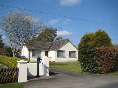
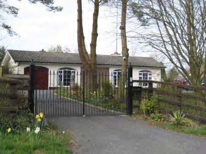
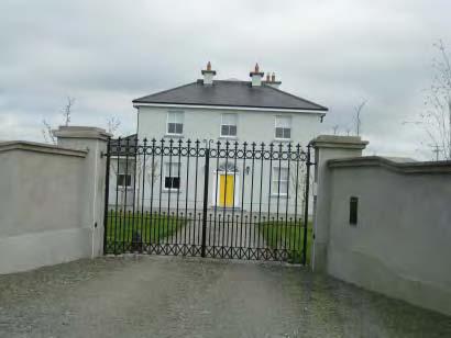
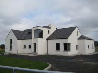
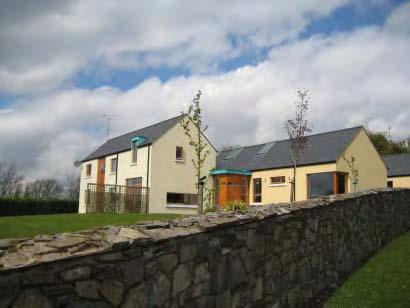
11 Contemporary Housing in the Area Examples of recently completed contemporary style houses in the area 71
12 2.4 Boundary of Tara Skryne Landscape Conservation Area (Draft) The European Landscape Convention states that landscape means an area, as perceived by people, whose character is the result of the action and interaction of natural and/or human factors. Particular combinations of geology, landform, soils, vegetation, land use, field patterns and human settlements create landscape character which makes one place different from another. Experience, memories, perceptions History and human activity Land Use (settlement, farming, forestry etc.) Plants and animals Geology, soils, rivers and drainage, landform. Figure 5 Components of a landscape Process to define the boundary of the Landscape Conservation Area (Draft) The draft boundary of the Tara Skryne Landscape Conservation Area has been informed by: 1. Desk-study to review existing research and published material on the Tara Skryne Landscape (see Section 1.4) 2. Creating a Project GIS and preparing map overlays as the basis for defining an area of common character (see Section 1.4) 72
 5.")
13 3. Stakeholder meetings, pre draft public consultation events (Tara, Skryne and Navan) and a participatory boundary workshop (all reports available on project website 4. Physical Landscape Study (topography, geology, surface hydrology, soils and land use) 5. Visual Assessment of the Landscape Defining the Tara Skryne Landscape Conservation Area (Draft) Information gathering (desk based research) Project GIS map analysis and overlays Pre draft public events Tara and Skryne March 9 th and 11 th 2010 Participatory boundary workshop March 24 th 2010 Field Survey - Visual Character Assessment April 2010 Field Survey - Physical Character Assessment April 2010 Ground Truth Draft Boundary April 2010 Publish Draft Landscape Conservation Area May 2010 Public consultation on Draft Landscape Conservation Area May 4 th to June 16 th 2010 Consider submissions on draft Tara Skryne Landscape Conservation Area June 2010 Propose Tara Skryne Landscape Conservation Area Order for adoption July 2010 Figure 6 Flowchart of process to establish the Tara Skryne Landscape Conservation Area boundary (Draft) Draft boundary The Draft Landscape Conservation area is illustrated on Map 1 titled Draft Tara Skryne Landscape Conservation Area Map 1. 73
14 Relationship with County Meath Landscape Character Assessment 2007 The County Meath Development Plan contains the County Meath Landscape Character Assessment which has been prepared as a supplementary guidance to provide an understanding of landscapes in County Meath during the period of the Development Plan The County is divided into 4 Landscape Character Types (LCT s) representing generic areas of distinctive character such as uplands or river corridors. These LCT s are sub-divided into 20 Landscape Character Areas (LCA s) which are geographically specific. The boundaries of the LCA s were determined by desktop research and then refined by site survey. Generally, no single landscape element is overriding in its importance and individual elements, for example topography, may be similar across adjoining LCA s whilst the overall character varies. The Tara Skreen Hills have been classified as Landscape Character Area 12 as part of the county survey. The Draft Tara Skryne Landscape Conservation Area is a subset of Landscape Character Area 12. The County Landscape Character Assessment included all areas underlain by Namurian Shale bedrock as part of the Tara Skreen Hills, and stretched as far as Dunshaughlin, while also including the ridges at Culmullin, Summerhill and Garadice in the southern extreme of County Meath. The Tara Skryne Landscape Conservation (Draft) was based on a detailed analysis of the area and included a visual landscape assessment and community input. 74
15 2.5 Planning Implications of the Landscape Conservation Area Designation 1. The principal function of Section 204 of the Planning and Development Act is to allow a Planning Authority to identify and designate a landscape within its area for the purposes of its preservation. 2. Meath County Council in exercising this power is giving effect to an objective in the County Development Plan to designate the historic Tara Skryne Landscape as a Landscape Conservation Area (HER POL 65 and HER POL 113 Section Heritage Landscapes refers) and to the policies and objectives contained within the Plan which relate to the Tara Skryne Landscape (Appendix IV). 3. The Meath County Development Plan sets out appropriate planning and sustainable development objectives for the county and will continue to provide the framework against which individual planning applications are assessed in the Tara Skryne Landscape. The Rural Housing Policy for the area as set out in the current Meath County Development Plan will remain unchanged by the Landscape Conservation Area designation. 4. Section 4 of the Planning and Development Act 2000 lists categories of development that constitute exempted development for the purposes of the Act. The Planning and Development Regulations, 2001 in Schedule 2 list certain developments that currently constitute exempted development subject to conditions and limitations. Section 204 of the Planning and Development Act 2000 allows a Planning Authority, when designating a Landscape Conservation Area, to specify categories of exempted development which now require planning permission in the LCA area. In this regard, development that was previously exempt from planning permission under the Planning and Development Regulations 2001 which will now require planning permission is set out in Schedule I. 5. To protect the views and character of this landscape, design and siting will be important factors in accommodating new development. It is an objective of the 75
16 Meath County Development Plan to prepare a rural design guide for one off housing in County Meath. The guide was completed in December 2009 and is available on The guide acknowledges that County Meath possesses high quality landscapes and a rich built fabric. In the past the emphasis in Irish vernacular rural dwelling design was on good siting making use of available shelter, a simple design and use of local materials. The guide was commissioned in order to positively encourage the application of good siting and design principals to new single house development in the countryside. Single house developments constructed in the LCA should be of an excellent standard, complimenting the landscape of which they will form a part and should contribute in a positive manner to the built heritage of the County. The guide recognises that rural dwelling design needs to respond to the requirements of the modern rural dweller. The guide therefore encourages the application of building forms that are from the traditional Irish vernacular as a reference in developing a design for a contemporary rural dwelling. 6. The County Development Plan protects two key view points within the Tara Skryne Landscape Conservation Area (Draft) View Reference Townland in which view is located VP1 Hill of Tara Jordanstown, Castletown Tara, Castleboy, Belpere and Cabragh VP 27 Skryne Views and Prospects A summary visual assessment of the above key views is given below. It is an objective of Meath County Development Plan to protect these view and prospects from inappropriate development (HER POL 113). Skryne Hill (VP27) Context : View westwards from Skryne Hill. A panorama view westwards towards Tara (3.0km) across the Gabhra valley at an elevation of +172mOD approx. Skryne Hill is the highest point within the surrounding landscape including Tara (+159mOD) and as such affords panorama views to the west (Tara), north and east. Views directly south are 76
17 restricted by existing trees and buildings. The views westwards are contained within the valley by the topography of the Hill of Tara. This view has been identified in the Meath County Development Plan as being a protected view (VP27), in that it is a very important view towards Tara across valley/historical/tourism etc. Main Visual Elements: From this viewpoint the Hill of Tara (3.0km) is well defined as the land rises gently to the main visual reference of the Hill of Tara, identifiable by the woodland copse which breaks the skyline on the horizon. Pasture fields with field hedgerows and hedgerow trees dominate the view in the foreground and middle distance. The landscape character within the valley appears open as a number of hedgerows within the valley, whilst containing a number of mature trees, are not substantial in scale and depth and as such do not provide significant vegetative cover or screening. The River Gabhra runs through the valley and feeds into the River Skane at Dowdstown bridge, but is not visible from this viewpoint. Views of residential dwellings and agricultural buildings are restricted to the lower slopes of the Hill of Tara, primarily located along the N3. The cluster of buildings at the Hill of Tara car park are also visible. Glimpse views of the recently constructed M3 road cuttings (not yet vegetated) and a bridge on the M3 through the valley south of Tara are also possible from this viewpoint. Lowland lands to the north of Tara provide long range views north-westwards for several kilometres on a clear day. However a significant numbers of residential dwellings/agricultural buildings are present in the view. The main visual elements within the landscape in this location are: 77
18 open landscape character within the Gabhra valley consisting of pasture fields and hedgerows/hedgerow trees Hill of Tara and woodland copse on the Hill of Tara skyline views of residential/agricultural buildings restricted to N3 glimpse views of cuttings and bridge on recently constructed M3 lowlands north of Tara provide long range views north-westwards View west from Hill of Skryne (VP27) Hill of Tara (VP1) Context: This is a Key View westwards from Hill of Tara, identified within the Meath County Development Plan, VP1; it is acknowledged and already designated a very important view/historical/tourism etc. The view is a panorama view westwards across the Skane and Boyne valleys at an elevation of +159mOD. Main Visual Elements The woodland trees located on the upper western slopes of Tara in combination with the network of field hedgerows and hedgerow trees are prominent and provide significant depth and screening to the view. This network of vegetation gives the appearance of a wooded landscape and as such significantly restricts views of a number of dwellings and 78
19 farm buildings located within the lowlands. However, a small number of dwellings and farm buildings are visible, which while not being fully visible somewhat detract from this important panorama view. Distant views are possible beyond Boyne valley on clear days. The main visual elements within the landscape in this location are: woodland trees located on the upper western slopes of Tara pasture and arable fields and network of hedgerows and hedgerow trees within the lowland drumlin landscape distant glimpse views of gently rolling topography/hills in the lowlands View west from Hill of Tara (VP1) 79
National Character Area 70 Melbourne Parklands
 Summary The are a landscape of rolling farmland, parkland and woodland on the northern flanks of the ridge between Burton upon Trent and Swadlincote. The land slopes down to the River Trent, which borders
LANDSCAPE CHARACTER ASSESSMENT
 THE COUNTY DURHAM LANDSCAPE CHARACTER ASSESSMENT FOREWORD The landscape of County Durham is one of great contrast and diversity. From the North Pennines in the west to the Durham Coast in the east it contains
Case Studies; Meitheal Clusters Applied to Villages and Rural Settlements
 Case Studies; Meitheal Clusters Applied to Villages and Rural Settlements 23.3.9 (ii) Case Studies, Meitheal Clusters applied to villages and rural settlments Fig 22.3.12 Cluster site plan; church opposite
Toddington Central Bedfordshire Stage 3 Green Belt Study December 2017
 Toddington Central Bedfordshire Stage 3 Green Belt Study December 2017 Site: ALP086 - Middle Lakes, Toddington Site size (ha): 2.83 Site: ALP086 - Middle Lakes, Toddington Site size (ha): 2.83 Site description
Landscape Character Assessment
 Landscape Character Assessment What Is It? Survey of the county landscapes For what purpose? To analyse and define character Says Who? Planning and Development Act 2000 Applications To provide a basis
APPENDIX 12 - PROTECTED VIEWS AND PROSPECTS
 APPENDIX 12 - PROTECTED VIEWS AND PROSPECTS List of protected views and prospects as shown on Maps 9.5.1 to 9.5.6 View Location Description Significance 1 County road View looking west across mixed landscape
CHAPTER 11 LANDSCAPE. Appendix 11.1 Tables - Landscape Evaluation MSA
 CHAPTER 11 LANDSCAPE Appendix 11.1 Tables - Landscape Evaluation MSA Appendix 11.1 Tables Table 11.1 Guidelines used in the preparation of the Landscape and Visual Impact Assessment Environmental Protection
Environmental Protection Agency, EPA (2003). Advice Notes on Current Practice in the preparation of EIS, Ireland;
. Advice Notes on Current Practice in the preparation of EIS, Ireland;") Appendix 11.1 Tables Table 11.1 Guidelines used in the preparation of the Landscape and Visual Impact Assessment Environmental Protection Agency, EPA (2003). Advice Notes on Current Practice in the preparation
Appendix 11.1 Tables Table 11.1 Guidelines used in the preparation of the Landscape and Visual Impact Assessment Environmental Protection Agency, EPA (2003). Advice Notes on Current Practice in the preparation
INTRODUCTION. Land West of Main Road, Stanton Harcourt THE SITE. Why is the Site Suitable for Development?
 0 INTRODUCTION THE SITE Application Boundary Gladman Developments Ltd has successfully invested in communities throughout the UK over the past 0 years, developing high quality and sustainable residential,
LONGDEN VILLAGE DEVELOPMENT STATEMENT
 LONGDEN VILLAGE DEVELOPMENT STATEMENT 2017-2027 1 Longden Development Statement 2017-2027 15/01/18 1. Background 1.1 Longden Village Longden village is a very rural and traditional community first mentioned
DESIGN & ACCESS STATEMENT
 . DESIGN & ACCESS STATEMENT Site Adjacent to The Manor House, Upper Street,, Kingsdown, Deal, Kent. DESIGNS ARCHITECTURE + PLANNING CONTENTS Design and Access Statement Introduction Site and Location Planning
Design Guidelines. High Point Estates Design Guidelines April Gomberoff Bell Lyon Architects Group Inc.
 High Point Estates April 2006 Gomberoff Bell Lyon Architects Group Inc. 1 29 Contents Part One The Building Scheme Part Two Architectural Character and Siting Building Part One: The Building Scheme i 31
Rathmolyon Written Statement
 Settlement Rathmolyon Position in Settlement Hierarchy Village - Local centre for services and local enterprise development Position in Retail Strategy Fourth tier retail centre Population (2011) Census
Totternhoe Central Bedfordshire Stage 3 Green Belt Study December 2017
 Totternhoe Central Bedfordshire Stage 3 Green Belt Study December 2017 Site description The site is comprised of a single arable field on the southern side of the washed over settlement of Totternhoe.
Warwickshire County Council. Upper and Lower Brailes. Landscape Study
 Warwickshire County Council Upper and Lower Brailes Landscape Study Produced by WCC Landscape Architects March 2016 Landscape Assessment of Potential Development Sites within the parish of Brailes 1.0
BROADHEMBURY DESIGN STATEMENT
 BROADHEMBURY DESIGN STATEMENT As drawn up by Broadhembury Parish Council during the development of a Parish Plan and adopted at its meeting on 17 th May 2010 BROADHEMBURY DESIGN STATEMENT Contents Introduction
Carnaross Written Statement
 Ca n rrnarrossss W t rriittten Sttattementt Settlement Position in Settlement Hierarchy Position in Retail Strategy Population (2011) Geodirectory (No census data available) Committed Housing Units (Not
Environmental and Landscape Mapping
 Environmental and Landscape Mapping In support of the Calveley Neighbourhood Plan November 2016 Project Name and Number: Calveley Neighbourhood Plan 16-025 Document Name and Revision: Environmental and
Lancaster Conservation Area Appraisal. Character Area 8. Cathedral
 Lancaster Conservation Area Appraisal Character Area 8. Cathedral March 2013 118 3.8 Character Area 8. Cathedral 3.8.1. Definition of Special Interest "This character area is distinctive for the fine group
INTRODUCTION. Land south of Bishopswood Lane, Tadley
 0 INTRODUCTION THE SITE Introduction Gladman Developments Ltd. has successfully invested in communities throughout the UK over the past 0 years, developing high quality and sustainable residential, commercial
Appendix. Protected Views and Prospects
 12 Appendix A12 List of protected views and prospects as shown on Map 9.5.1. (Written text supersedes map) 1 County road Ross and Moneybeg View looking north west across mixed landscape of woodland and
ENVIRONMENTAL AND LANDSCAPE MAPPING
 APPENDIX IV : Environmental and Landscape Mapping ENVIRONMENTAL AND LANDSCAPE MAPPING Calveley Neighbourhood Plan November 2016 ENVIRONMENTAL AND LANDSCAPE MAPPING Calveley Neighbourhood Plan Calveley
8.0 Design and Form of Development 43/
 42/ 8.0 Design and Form of Development 43/ Rothwells Farm, Golborne/ Development Statement Figure 7. Site Constraints Key 44/ Site Boundary 360 Bus Route/Stops Existing Trees Underground Water Pipe Sensitive
STATEMENT OF OBJECTION TO THE PROPOSED DEVELOPMENT OF LAND AT CHURCH CLIFF DRIVE FILEY
 STATEMENT OF OBJECTION TO THE PROPOSED DEVELOPMENT OF LAND AT CHURCH CLIFF DRIVE FILEY You will be aware that Scarborough borough council have adopted a new local plan that includes land at Church Cliff
Glencullen Local Area Plan 2008
 www.dlrcoco.ie Glencullen Local Area Plan 2008 Economic Development & Planning Department Dún Laoghaire-Rathdown County Council March 2008 Glencullen Local Area Plan 2008 The Glencullen Local Area Plan
WELCOME. Olney Road, Lavendon INTRODUCTION. The Site. The Application. The Need for Housing. A Sustainable Location LAVENDON TURVEY OLNEY ROAD
 0 WELCOME INTRODUCTION Gladman Developments Ltd have successfully invested in communities throughout the UK over the past 0 years, developing high quality and sustainable residential, commercial and industrial
Cotswolds AONB Landscape Strategy and Guidelines. June 2016
 Cotswolds AONB Landscape Strategy and Guidelines June 2016 Cotswolds AONB Landscape Strategy and Guidelines Introduction The evolution of the landscape of the Cotswolds AONB is a result of the interaction
CLOUGHJORDAN SETTLEMENT PLAN
 CLOUGHJORDAN SETTLEMENT PLAN 1.0 General Introduction and Development Context Location The market town of Cloughjordan lies close to the border with Offaly at the junction of the R490 and R491 Regional
Site ref: AS06 Site Name or Address: Murreys Court, Agates Lane
 Site ref: AS06 Site Name or Address: Murreys Court, Agates Lane Proposed Land Use: Total Site Area (Ha): Housing 1.85 Ha Description: It is understood that the owner has no plans to dispose of the site
BORRISOKANE SETTLEMENT PLAN
 BORRISOKANE SETTLEMENT PLAN 1.0 General Introduction and Development Context Location Borrisokane is located 15km north of Nenagh on the N52. While the town is primarily residential, it acts as a market
Salhouse Parish Council, 11 th November Response to Planning Application
 Salhouse Parish Council, 11 th November 2013 Response to Planning Application 20131408 Summary Salhouse Parish Council (SPC) has received via Broadland District Council a Planning Application for a 5MWp
To secure a Green Belt around Cambridge whose boundaries are clearly defined and which will endure for the plan period and beyond.
 4. GREEN BELT OBJECTIVES GB/a GB/b GB/c GB/d To secure a Green Belt around Cambridge whose boundaries are clearly defined and which will endure for the plan period and beyond. To maintain the purposes
APPENDIX 12 - PROTECTED VIEWS AND PROSPECTS
 APPENDIX 12 - PROTECTED VIEWS AND PROSPECTS List of protected views and prospects as shown on Maps 9.5.1. to 9.5.6 (Written text supersedes map) View Location Direction Description Significance 1 2 3 4
Environment Agency Flood Risk Map for the Village of Bridge
 Environment Agency Flood Risk Map for the Village of Bridge December 2016 21 Objective F. Conserving and Enhancing the Natural Environment The National Planning Policy Framework states that the planning
Settlement Boundaries Methodology North Northumberland Coast Neighbourhood Plan (August 2016)
") Introduction This background paper sets out a methodology for the definition of settlement boundaries in the North Northumberland Coast Neighbourhood Plan. The neighbourhood plan is planning positively
Introduction This background paper sets out a methodology for the definition of settlement boundaries in the North Northumberland Coast Neighbourhood Plan. The neighbourhood plan is planning positively
Name: Former Ornamental Garden and Trees at 1 Harestone Drive. Site is Grounds of 1 Harestone Drive formerly the Marie Curie Hospice.
 Name: Former Ornamental Garden and Trees at 1 Harestone Drive Location: Site is Grounds of 1 Harestone Drive formerly the Marie Curie Hospice. No.48 Coloured Red on plan. Description. Former site of Harestone
13. London Bridge London Bridge Area Vision
 13. 13.1. Area Vision 13.1.1. is: A globally significant central London business district which is home to international business headquarters; Internationally renowned for its prominent riverfront location
Landscape considerations in Forests & Woodlands. Jill Bullen, Senior Landscape Specialist
 Landscape considerations in Forests & Woodlands Jill Bullen, Senior Landscape Specialist UK Forestry Standard (UKFS) Sustainable forest management Landscape sub-section (S6.4, page 96) Standards and requirements
Alder View. Introduction. Alder View. Harwell. The Vision. The Team. Taylor Wimpey
 Introduction Welcome to the public exhibition for, a development by Taylor Wimpey on the land south of Grove Road,. This exhibition will provide an overview of the development proposals for the site and
Tara Skryne Landscape Conservation Area Project: Progress Report: Phase 1
 Tara Skryne Landscape Conservation Area Project: Progress Report: Phase 1 A partnership project between Meath County Council, the Heritage Council and the Department of Environment, Heritage and Local
DRAFT TARA SKRYNE LANDSCAPE CONSERVATION AREA EXPLANATORY DOCUMENT
 DRAFT TARA SKRYNE LANDSCAPE CONSERVATION AREA EXPLANATORY DOCUMENT May 2010 Table of contents Section I Introduction Page 1.1 Introduction 2 1.2 Tara Skryne Landscape Conservation Area 4 1.3 National pilot
WELCOME GYPSY LANE. Wider Site Location plan. Proposals for the development of LAND OFF FOXLYDIATE LANE WEBHEATH. Proposals for the development of
 WELCOME The developers are preparing an outline planning application for a residential led development and need the community s views in order to develop the proposals further WHAT IS PROPOSED? A high
HIGH LITTLETON AND HALLATROW COMMUNITY PLACEMAKING PLAN
 HIGH LITTLETON AND HALLATROW COMMUNITY PLACEMAKING PLAN DOCUMENT 3 of 4 SNAPSHOT CHARACTER SUMMARY HALLATROW Context B&NES Landscape type: Area 6 Farrington Gurney Farmland/ Area 12 Cam and Wellow Brook
Rolling Wooded Pasture Lulworth Wooded Pasture Rempstone Wooded Pasture
 Landscape type: Character areas: Rolling Wooded Pasture Lulworth Wooded Pasture Rempstone Wooded Pasture The rolling wooded pasture landscape type is found around the margins of the Dorset Heaths. Although
Landscape Policy in Ireland insights from the Heritage Council
 Landscape Policy in Ireland insights from the Heritage Council Ian Doyle Head of Conservation What am I going to talk about? What is landscape? European Landscape Convention Local landscape projects Methods
Application and Proposals. Part 211
 Application and Proposals Part 211 Site Location and Context The application site comprises two distinct land parcels totalling some 135 hectares. The site is bisected eastwest by Churchlands Development.
7.1 Area 1: Haslemere Conservation Area
 7.1 Area 1: Haslemere Conservation Area Detailed map of Haslemere Town Conservation Area as of 2006 Crown copyright and database right 2011 Ordnance Survey LA100025451 27 The Conservation Area is characterised
Infill Residential Design Guidelines
 Infill Residential Design Guidelines Adopted March 23, 2004 Amended September 10, 2013 City of Orange Community Development Department Planning Division Phone: (714) 744-7220 Fax: (714) 744-7222 www.cityoforange.org
Neighbourhood Plan Representation
 Date: 10 th November 2017 Neighbourhood Plan Representation Land to the east of Callow Hill Road, Alvechurch Introduction This representation has been prepared by RPS Planning and Development on behalf
ACTION TAKEN BY CABINET MEMBER (EXECUTIVE FUNCTION) 26 September 2013
 26 September 2013") ACTION TAKEN BY CABINET MEMBER (EXECUTIVE FUNCTION) Subject Finchley Garden Village Conservation Area Character Appraisal, Management Proposals and Design Guidance Cabinet Member Date of Decision 26 September
ACTION TAKEN BY CABINET MEMBER (EXECUTIVE FUNCTION) Subject Finchley Garden Village Conservation Area Character Appraisal, Management Proposals and Design Guidance Cabinet Member Date of Decision 26 September
Site Assessment Technical Document Appendix A: Glossary
 Central Bedfordshire Council www.centralbedfordshire.gov.uk Site Assessment Technical Document Appendix A: Glossary July 2017 1.1.11-1 - ii Appendix A: Glossary Term Agricultural Land Classification AONB
Willey Cottage Chamber Lane, Farnham, Surrey
 Willey Cottage Chamber Lane, Farnham, Surrey Willey Cottage Chamber Lane, Farnham, Surrey, GU10 5ET A unique opportunity to acquire two detached dwellings in a glorious rural setting with fine views and
3(iv)(b) TCP/11/16(29)
(b) TCP/11/16(29)") 3(iv)(b) TCP/11/16(29) TCP/11/16(29) Planning Application 09/02229/AML Erection of a dwellinghouse, garage with upper floor accommodation and stables (Approval of Matters Specified by Conditions) at land
3(iv)(b) TCP/11/16(29) TCP/11/16(29) Planning Application 09/02229/AML Erection of a dwellinghouse, garage with upper floor accommodation and stables (Approval of Matters Specified by Conditions) at land
THE CLOCKHOUSE. Capel, Nr Dorking, Surrey
 THE CLOCKHOUSE Capel, Nr Dorking, Surrey THE CLOCKHOUSE Horsham Road, Capel, Dorking, Surrey. A stunning Grade II listed country house with beautiful landscaped gardens, light woodland and lake. Dorking
Welcome to our exhibition
 Welcome to our exhibition The Homes & Communities Agency (HCA) welcomes you to this public exhibition explaining our proposals for the redevelopment of the former Lea Castle Hospital site. About the Homes
PUBLIC REALM STRATEGY
 CONSULTATION DRAFT PUBLIC REALM STRATEGY Trenchard Street & Frogmore Street City Design Group Place Directorate Public Realm Strategy Trenchard Street & Frogmore Street Contents 1. Introduction 2. Understanding
County Development Plan Consolidated Draft + Adopted Amendments August 2017 Volume 2, Chapter 22 Easky Mini-Plan
 22. Easky Mini-Plan Village profile Easky is a coastal settlement located approximately 40 km to the west of Sligo City, in a designated Rural Area In Need of Regeneration. The nearby coastline is designated
Statement of Community Involvement LAND OFF SOUTHDOWN ROAD HORNDEAN, HAMPSHIRE
 LAND OFF SOUTHDOWN ROAD HORNDEAN, HAMPSHIRE CONTENTS Page 1. Introduction 3 2. Pre-application Discussions 4 3. The Consultation Process 5 4. Consultation Feedback 7 5. Responses to Consultation Feedback
WELCOME. Land west of Great Canfield Road, Takeley. Welcome. Have your say. Pegasus Urban Design
 01 WELCOME Welcome Gladman Developments Ltd have successfully invested in communities throughout the UK over the past 20 years, developing high quality and sustainable residential, commercial and industrial
Development in the Green Belt
 Supplementary Planning Document: Development in the Green Belt Consultation Draft February 2013 Local Development Framework How to comment This document was published on 21st March 2013 and comments should
LETTER OF OBJECTION LAND TO THE SOUTH WEST OF FORGE GARAGE, HIGH STREET, PENSHURST, KENT, TN11 8BU
 Senior Planning Officer Andrew Byrne Sevenoaks District Council Community & Planning Services PO Box 183 Argyle Road Sevenoaks Kent TN13 1GN 04 November 2011 Your Ref: 11/02258/FUL For the attention of
Conservation Area Designation, amendments and Review
 Conservation Area Designation, amendments and Review Location: No.s 37-49 (odd) Twickenham Road Date Assessed: January 2018 Adjacent Conservation Area Significance: Teddington Lock CA. The Teddington Lock
Lincoln Townscape Assessment. Boultham Park Inherited Character Area Statement
 Lincoln Townscape Assessment Boultham Park Inherited Character Area Statement January 2008 Page 2 of 12 Table of Contents Page Overview 2 Historical Development 2 Urban form 3 Views 5 Condition of Buildings
HERITAGE STATEMENT AND IMPACT ASSESSMENT HILLBARK FARMHOUSE FRANKBY
 HILLBARK FARMHOUSE HERITAGE STATEMENT AND IMPACT ASSESSMENT HILLBARK FARMHOUSE FRONT ENTRANCE CONTENTS Executive summary 1.0 INTRODUCTION 1.1. Background to the report 1.2. Purpose of the Report 2.0 SIGNIFICANCE
Wind energy development in the South Pennines landscape
 Wind energy development in the South Pennines landscape Programme for today Background Policy context South Pennines landscape Impacts of wind energy development The South Pennines Wind Energy Landscape
Emmer Green, Reading. Site Location Plan
 0 Welcome Introduction Gladman Developments Ltd have successfully invested in communities throughout the UK over the past 0 years, developing high quality and sustainable residential, commercial and industrial
Kilmessan LOCAL AREA PLAN. Adopted 25th May, 2009.
 Kilmessan LOCAL AREA PLAN 2009 2015 Adopted 25th May, 2009. Table of Contents 1.0 INTRODUCTION 4 1.1 Statutoty Context 4 1.1.1 Scope of the LAPs 4 1.1.2 Likely Significant Effects on the Environment 4
Landscape Assessment CEUGP/SR9B
 Landscape Assessment CEUGP/SR9B TABLE OF CONTENTS 1 STUDY PHILOSOPHY... 3 2 GENERAL DESCRIPTION OF SITE... 4 3 LANDSCAPE THEMES... 8 TABLE OF FIGURES Table 1: Landscape... 5 Table 2: Landscape Themes...
RURAL DEVELOPMENT FRAMEWORK
 Appendix 5 SUPPLEMENTARY PLANNING GUIDANCE RURAL DEVELOPMENT FRAMEWORK BUCHANAN SOUTH Final Draft for Committee Approval May 2017 Contents Buchanan South Rural Development Framework 1. Purpose 2. Local
Ratthcaiirrn Wrriitttten Sttattementt
 Ratthcaiirrn Wrriitttten Sttattementt Settlement Rathcairn Position in Settlement Hierarchy Village Serve a smaller rural catchment; provide local services with some smaller scale rural enterprises in
Clonard Written Statement
 Settlement Clonard Position in Settlement Hierarchy Village - Local centre for services and local enterprise development Position in Retail Strategy Fourth tier retail centre Population (2011) Census 339
an Inspector appointed by the Secretary of State for Communities and Local Government
 Appeal Decision Site visit made on 23 January 2017 by Gareth Wildgoose BSc (Hons) MSc MRTPI an Inspector appointed by the Secretary of State for Communities and Local Government Decision date: 6 February
7. The Landscape. 7.1 Introduction. Environmental Impact Statement (EIS) Scoping Report
 Scoping Report") 7. The Landscape 7.1 Introduction The purpose of this section of the EIS Scoping Report is to describe the scope of work and methods to be applied in the identification and assessment of landscape and
7. The Landscape 7.1 Introduction The purpose of this section of the EIS Scoping Report is to describe the scope of work and methods to be applied in the identification and assessment of landscape and
Genex Kidston Connection Project: Draf t Environmental Assessment Report Powerlink Queensland
 : Draf t Environmental Assessment Report Powerlink Queensland Chapter 14 \\autsv1fp001\projects\605x\60577456\6. Draft Docs\6.1 Reports\4. Compiled draft 17 September\Covers\Chapters\Ch 14.docx Rev ision
DESIGN AND MANAGEMENT PART 3 HA 57/92 NEW ROADS INTEGRATION WITH RURAL LANDSCAPES SUMMARY
 DESIGN MANUAL FOR ROADS AND BRIDGES VOLUME 10 SECTION 1 ENVIRONMENTAL DESIGN AND MANAGEMENT NEW ROADS PART 3 HA 57/92 NEW ROADS INTEGRATION WITH RURAL LANDSCAPES SUMMARY This Advice Note gives guidance
Kilmessan Written Statement
 Settlement Kilmessan Position in Settlement Hierarchy Village - Local centre for services and local enterprise development Position in Retail Strategy Fourth tier retail centre Population (2011) Census
L 4-1. Heritage Report: Reasons for Heritage Designation. Kodors House. 35 Rosedale Avenue West
 L 4-1 Brampton Heritage Board Date: January 17, 2012 Heritage Report: Reasons for Heritage Designation Kodors House 35 Rosedale Avenue West December 2011 1 L 4-2 Profile of Subject Property Municipal Address
Planning Appraisal. Land Adjacent to Norton House Hotel, Edinburgh. May 2017
 Planning Appraisal Land Adjacent to Norton House Hotel, Edinburgh May 2017 Clarendon Planning and Development Ltd Introduction Clarendon Planning and Development Ltd have been requested to provide a summary
ASSESSMENT OF LANDCAPE PROVISIONS FOR PROPOSED PLAN CHANGE 5. Local Business Zone PALMERSTON NORTH CITY COUNCIL FINAL
 Hawke s Bay Office: PO Box 8823 Havelock North john@hudsonassociates.co.nz Ph 06 877 9808 M 021 324 409 A division of Hudson Group Ltd ASSESSMENT OF LANDCAPE PROVISIONS FOR PROPOSED PLAN CHANGE 5 Local
CHAPTER 5: GUIDING PRINCIPLES
 CHAPTER 5: GUIDING PRINCIPLES The following 10 principles were developed based on public consultation, planning policy and the background analysis conducted during Phase 1. The Guiding Principles significantly
Longhorsley Neighbourhood Plan
 Site Assessment 1. The availability of the site 1.1 Is the land owner willing for their site to be made available for development? 1.2 If yes, do you have any written evidence to back this up? Planning
Strip Enclosure. Summary of Dominant Character
 Strip Enclosure Summary of Dominant Character This zone is characterised by long thin curving fields, sometimes all running in the same direction and sometimes forming a patchwork pattern across the landscape.
TARA SKRYNE LANDSCAPE CONSERVATION AREA. Breakfast Briefing to Elected Members of Meath County Council
 TARA SKRYNE LANDSCAPE CONSERVATION AREA Breakfast Briefing to Elected Members of Meath County Council Wendy Bagnall, Forward Planning 7 th Sept 2010 Format of Presentation Introduction & Background to
MATURE SUBURBS RESIDENTIAL DEVELOPMENT GUIDELINES
 MATURE SUBURBS RESIDENTIAL DEVELOPMENT GUIDELINES DRAFT FEBRUARY 2005 BIRMINGHAM CITY COUNCIL 1 Introduction Mature Suburbs Residential Development Guidelines - Interim Supplementary Planning Advice -
DONCASTER METROPOLITAN BOROUGH COUNCIL. PLANNING COMMITTEE - 15th October Expiry Date:
 DONCASTER METROPOLITAN BOROUGH COUNCIL PLANNING COMMITTEE - 15th October 2013 Application 3 Application Number: 13/01158/FUL Application Expiry Date: 31st July 2013 Application Type: Full Application Proposal
CAERNARFON DEPENDENCY CATCHMENT AREA
 CAERNARFON DEPENDENCY CATCHMENT AREA GWYNEDD UNITARY DEVELOPMENT PLAN - HOUSING Map not to scale Dependency Catchment Area Location 2 Caernarfon Topic Housing To the rear of Bro Eglwys, Bethel. Grid Ref.
30. Riverstown Mini-Plan
 County Development Plan 2017-2023 Consolidated Draft + Adopted Amendments August 2017 Volume 2, Chapter 30 Riverstown Mini-Plan 30. Riverstown Mini-Plan Village profile Riverstown is located approximately
STRENSALL RAILWAY BUILDINGS CONSERVATION AREA APPRAISAL. In association with Strensall with Towthorpe Parish Council
 STRENSALL RAILWAY BUILDINGS CONSERVATION AREA APPRAISAL In association with Strensall with Towthorpe Parish Council CONTENTS Page 1 Introduction 2 2 Location and Context 3 3 Topography and Setting 4 4
Stowey Sutton Parish Council. Stowey Sutton Parish Council Placemaking Plan Assets of Community Value June 2014
 Stowey Sutton Parish Council Placemaking Plan Assets of Community Value June 2014 1 2 Contents Identifying natural & built environment assets... 5 Natural & built environment asset: Lovell Mill... 7 Natural
Conservation Area Designation, amendments and Review
 Conservation Area Designation, amendments and Review Location: Any area largely confined to Park Road and St. James Avenue which includes the following properties: St. James Church, St. James Road; No.
Welcome. Land adjacent Sandy Lane WALTHAM CHASE THE PROPOSED SITE
 Land adjacent Sandy Lane WALTHAM CHASE Existing Linden Homes developments Welcome Welcome to Linden Homes Southern s ( Linden ) public exhibition about its proposals for a range of high-quality homes for
Summary Note on Landscape and Visual Impact and Mitigation
 East Anglia TWO Offshore Windfarm Appendix 4.4 Summary Note on Landscape and Visual Impact and Mitigation Preliminary Environmental Information Volume 3 Document Reference EA2-DEVWF-ENV-REP-IBR- 000799_004
About 10% of the Borough's population lives in the seven rural parishes. Population figures from the 1991 census are given below:-
 8. THE DISTRICT VILLAGES 8.1 Population About 10% of the Borough's population lives in the seven rural parishes. Population figures from the 1991 census are given below:- Village No. of Persons Cottingham
The eight-week period for this application expires on 5 October 2006.
 06/01213/FUL CHANGE OF USE FROM AGRICULTURAL LAND TO PRIVATE CAR PARK AND NEW FENCING. AT Land To The South of Perceval Almhouses, Lower Weald, Calverton FOR Calverton Parochial Church Council INTRODUCTION
DISTINCTION IN BUILDING AWARDS 2016
 DISTINCTION IN BUILDING AWARDS 2016 The award scheme was introduced in 1992 with the aims of encouraging high standards of design and workmanship in developments in Worthing, and giving public recognition
4.3 Dudley Area Plan. Introduction. History and Existing Character. Desired Future Character for Dudley
 4.3 Dudley Area Plan Introduction The suburb of Dudley has developed as a result of various circumstances including its topography, history and mineral resources. Dudley development has been identified
National Monuments in State Care: Ownership & Guardianship. Meath
 : Ownership & Guardianship 4th March 2009 Meath National Monuments Service Seirbhís na Séadcomharthaí Náisiúnta www.archaeology.ie Disclaimer These data sets are based on records many of which date to
DESIGN & ACCESS STATEMENT
 DESIGN & ACCESS STATEMENT January 2016 Contents Introduction section 1 Section 1 - Introduction Section 2 - Assessment Section 3 - Involvement Section 4 - Evaluation Section 5 - Design Section 6 - Layout
Boyne Valley to Lakelands County Greenway. Feasibility Report. Navan Kingscourt Railway Committee
 Boyne Valley to Lakelands County Greenway Feasibility Report Navan Kingscourt Railway Committee June 2013 Quality Control Issue/revision Issue 1 Revision 1 Remarks DRAFT FINAL Date April 2013 June 19 th
General Terms Property, as used to describe eligibility for the National Register of Historic Places:
 Key Definitions Historic Landscapes Compiled by Camille Fife and Barbara Wyatt The field of historic landscape preservation has generated a specific vocabulary. Definitions have been published by two National