COASTAL PERMIT ADMINISTRATOR OCTOBER 27, 2016
|
|
|
- Nathan Dennis
- 5 years ago
- Views:
Transcription

1 COASTAL PERMIT ADMINISTRATOR OCTOBER 27, 2016 STAFF REPORT- CDP_STANDARD CDP_ SUMMARY OWNER/ APPLICANT: AGENT: REQUEST: PATRICK ELLIS AND LISA LAUER PO BOX 234 GUALALA, CA CARL RITTIMAN PO BOX 1700 MENDOCINO, CA A Coastal Development Standard Permit to repair and replace a leach field, pump tank, pump and control panel, and septic connecting lines. Minor trenching to bury the pump tank, connecting lines, and leach lines. Disturbed areas will be backfilled to original contours, seeded with native grasses, and or mulched. DATE DEEMED COMPLETE: March 30, 2016 LOCATION: The site is located on the west side of Highway 1 approximately 0.2 miles north of its intersection with Collins Landing Road or 2.5 miles north of Gualala SO HWY 1, GUALALA TOTAL ACREAGE: GENERAL PLAN: ZONING: 1.6 Acres Rural Residential- 5 acre minimum (RR5:R [RR-1]) Rural Residential- 5 acre minimum (RR:5) SUPERVISORIAL DISTRICT: 5 APPEALABLE AREA: ENVIRONMENTAL DETERMINATION: RECOMMENDATION: STAFF PLANNER: Yes (Blufftop and Highly Scenic Area) Categorically exempt pursuant with Section 15304(F), a Class 4 Categorical Exemption from CEQA for minor alterations of land, including minor trenching and backfilling where the surface is restored. Approve with conditions JULIANA CHERRY BACKGROUND PROJECT DESCRIPTION: A Coastal Development Permit to repair and replace a leach field, pump tank, pump and control panel, and septic connecting lines. Minor trenching to bury the pump tank, connecting lines, and leach lines. Disturbed areas will be backfilled to original contours, seeded with native grasses, and or mulched.
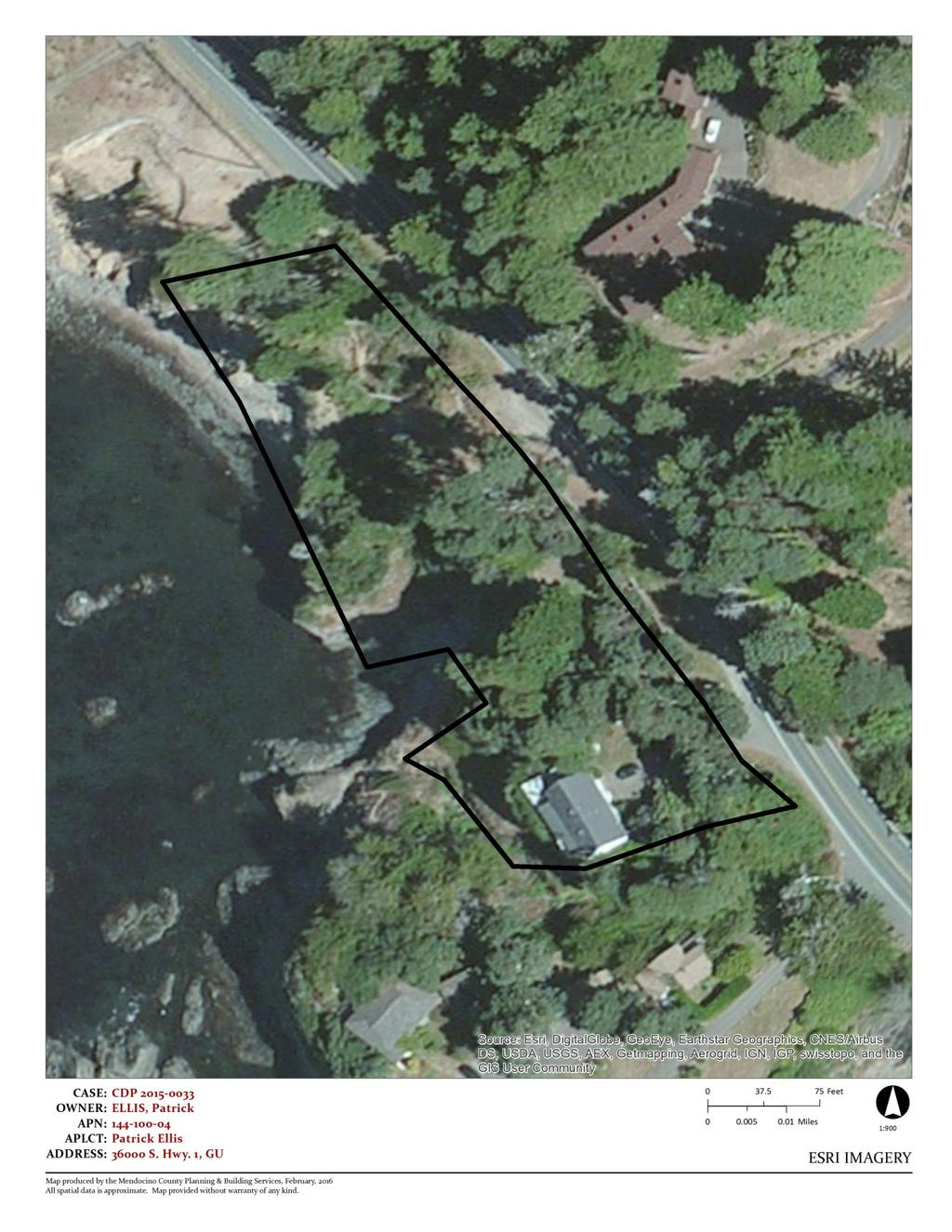
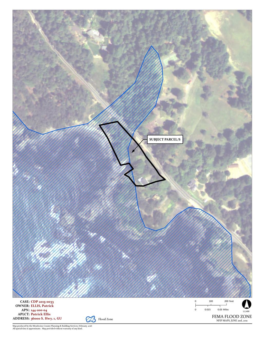
2 COASTAL PERMIT ADMINISTRATOR STAFF REPORT FOR CDP_ CDP_STANDARD PAGE 2 APPLICANT S STATEMENT: Repair of an existing three-bedroom septic system, including replacement of leach field, pump tank, pump and control panel, and connecting lines. No portion of the repair will be closer than the existing system to the bluff slope or an ephemeral drainage gulch, and the leach field will be further away from these features than the existing system. Three 18-inch trees will be removed to prevent root intrusion into the new leach lines, and all or some of the hedge will be removed to install the new pump chamber. Digging to bury the pump tank, connecting lines, and leach lines will move cubic yards during the project, which will be replaced and graded to match the existing topography, and the area will then be re-seeded with native grasses and/or mulched to prevent erosion. None of the areas impacted by this project are within public view from the highway, the shore, or any other public space. There is no well on the property. RELATED ON SITE APPLICATIONS: BF Roof repair BF Roof repair BF Solar panels mounted to the roof BF Electrical panel change from 100 AMP to 200 AMP BL Vacation Home Rental Business License SITE CHARACTERISTICS: The 1.6-acre site is located between State Route 1 and Mendocino County coastal bluffs. Portions of the parcel are mapped within FEMA 100-year flood zones. The project area avoids development within the flood zone. Water runoffs from the roadway are directed across the property. The project area is south of the existing ditch (or culvert). The site was originally developed in 1864 with the construction of a barn. During the s, the Assessor s Office has documentation that the barn was converted to a residential use and two additions were completed. Despite the parcel size, the land is highly constrained for development. Constraints include high risk for fire hazards; critical water resources; and bluffs with natural risk for erosion and exposure to ocean-wave rush, tsunami, flooding, and earthquakes. The parcel is situated within a designated Highly Scenic Area. SURROUNDING LAND USE AND ZONING: GENERAL PLAN ZONING LOT SIZES USES NORTH RR5 RR5 2 acres Residential EAST RR10 RR10 2 acres Residential SOUTH RR5 RR5 2 acres Residential WEST Ocean Ocean PUBLIC SERVICES: Access: Fire District: Water District: School District: MAC: State Route 1 is adjacent to the easterly property line South Coast Fire District North Gualala Water Company Arena Unified School District Gualala MAC AGENCY COMMENTS: On March 30, 2016, project referrals were sent to the following responsible or trustee agencies with jurisdiction over the Project. Their required related permits, if any, are listed below. Their submitted recommended conditions of approval are contained in Exhibit A of the attached resolution. A summary of the submitted agency comments are listed below. Any comment that would trigger a project modification or denial are discussed in full as key issues in the following section.
3 COASTAL PERMIT ADMINISTRATOR STAFF REPORT FOR CDP_ CDP_STANDARD PAGE 3 REFERRAL AGENCIES RELATED PERMIT COMMENT DATE PBS Planning Ukiah No response Department of Transportation No response PBS Building Inspection FB No comment Department of Environmental Health No response Assessor No response Northwest Information Center No response Archaeology Commission Comment State Clearinghouse Comment Caltrans No response CalFire No comment Department of Fish and Game Comment Coastal Commission No response Gualala Municipal Area Council Comment North Gualala Water Company Comment South Coast Fire District No response 1. General Plan and Zoning Consistency: KEY ISSUES The subject parcel is classified as Rural Residential (RR) by the Coastal Element of the Mendocino County General Plan, which is intended to encourage local small scale food production (farming) in areas which are not well suited for large scale commercial agriculture [and] is not intended to be a growth area and residences should be located as to create minimal impact on agricultural viability. The principally permitted use designated for the RR land use classification is residential and associated utilities, light agriculture, [and] home occupation. The proposed septic repairs (replacement leach field, pump tank, pump and control panel; and connecting lines) are consistent with the RR classification of the Coastal Element of the Mendocino County General Plan and Mendocino County Code (MCC) Chapters Rural Residential District, Hazard Areas, Coastal Access Regulations and Open Space Easements, and Section Required Findings for all Coastal Development Permits. Since the parcel is adjacent to a coastal bluff, two conditions of project approval are recommended. One establishes that the landowner assume the risk associated with bluff development and the second condition is to ensure that soil disturbance and the septic repair be completed during the dry season. The two conditions are included in the recommended resolution and Appendix A. 2. Mendocino County Local Coastal Plan: The subject parcel is located within a mapped Highly Scenic Area (HSA). It is a developed site and the proposed repairs do not include above grade changes to the land. No impact to visual resources is anticipated; therefore, the project conforms to the protection of visual resources as implemented by MCC Chapter The project site is located west of Highway 1. The Coastal Element of the General Plan designates this section of the highway as the public access route to the county s coastline. There is no evidence of prescriptive access on the developed site. The project would have no effect on public access to the coast; therefore, the proposed septic system repair and replacement is consistent with the public access and public recreation policies of the Coastal Element of the General Plan.
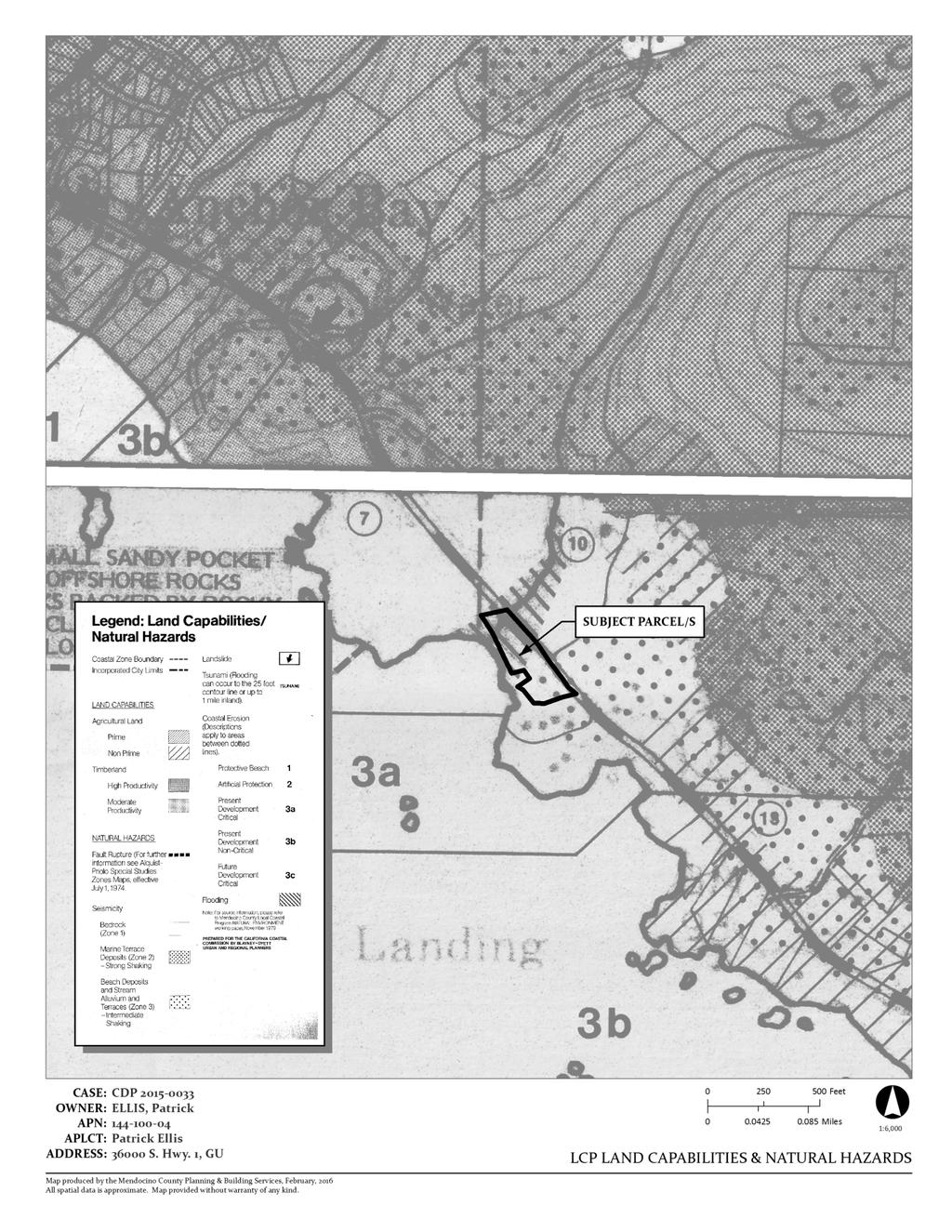
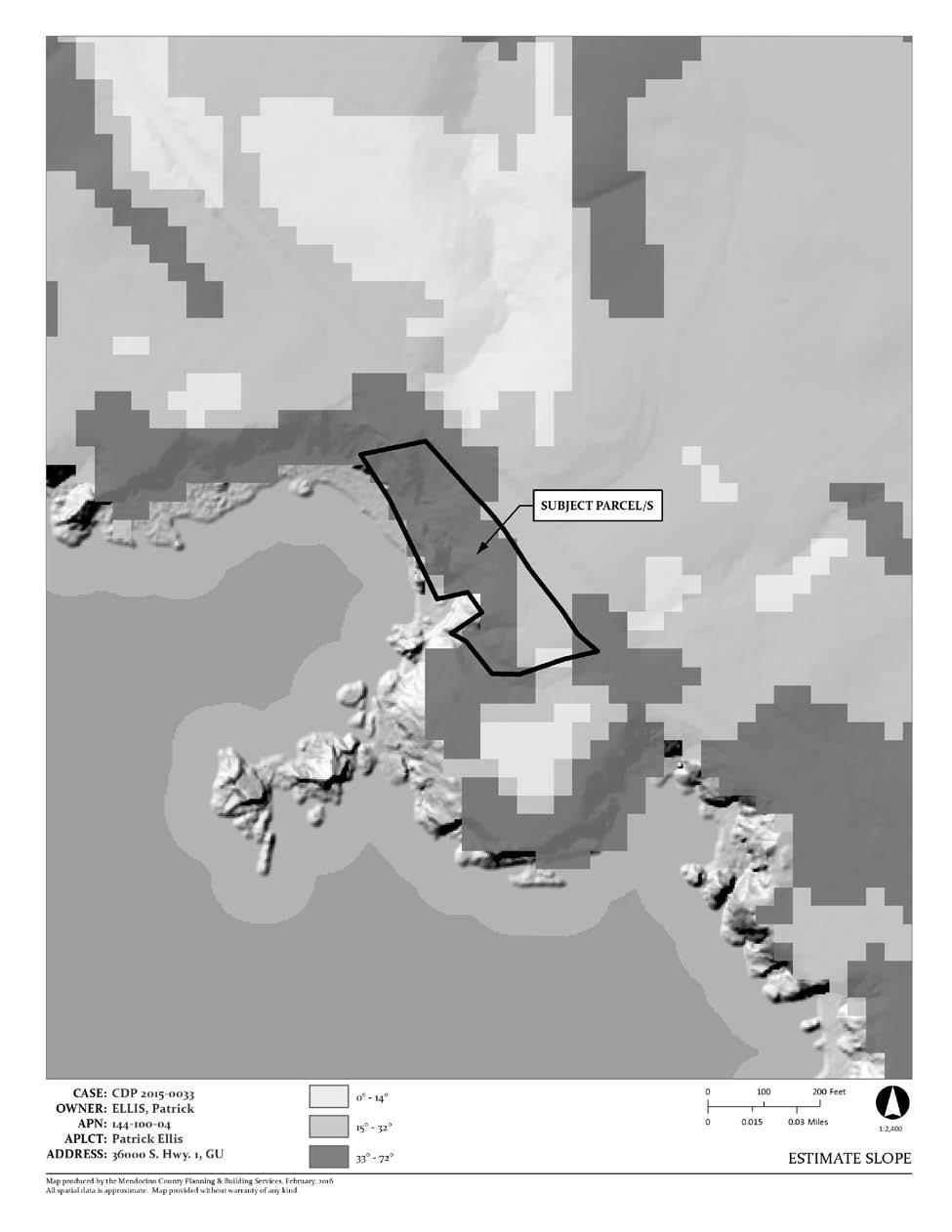
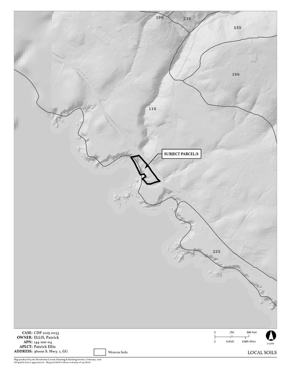
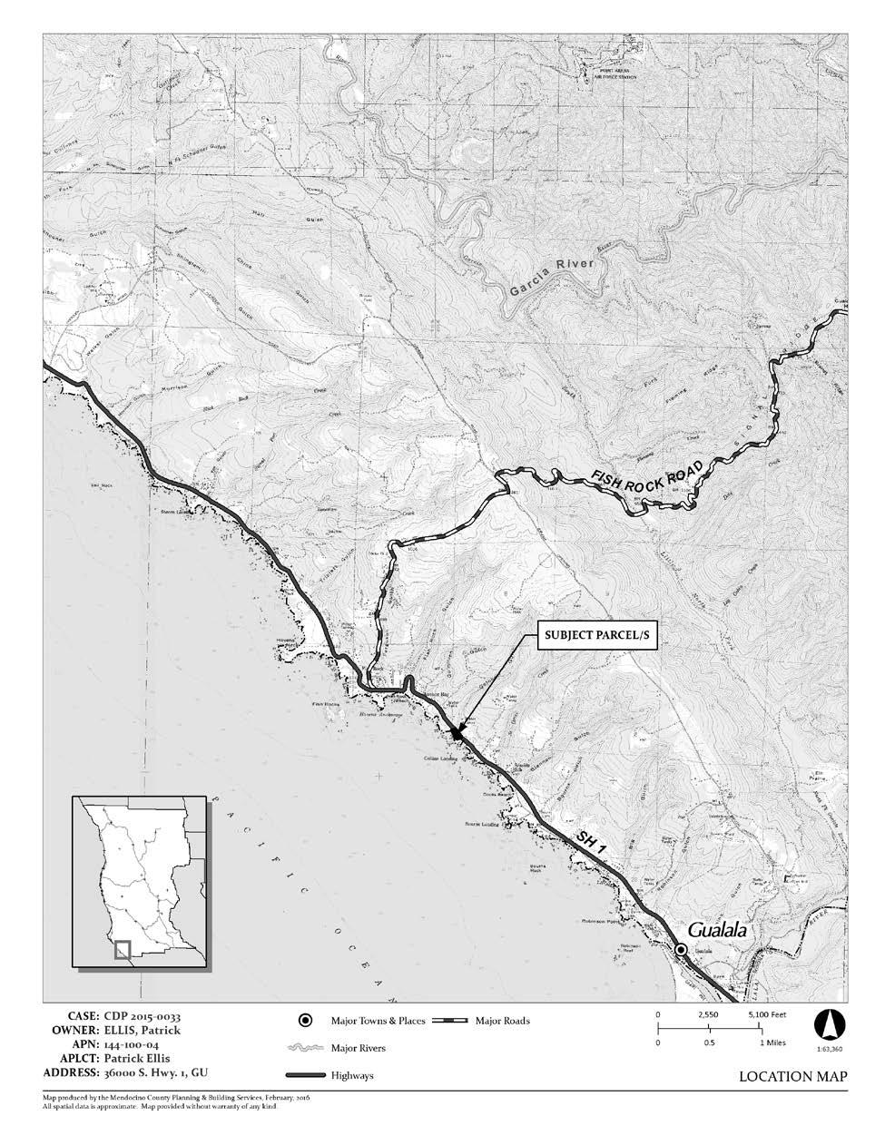
4 COASTAL PERMIT ADMINISTRATOR STAFF REPORT FOR CDP_ CDP_STANDARD PAGE 4 3. Department of Environmental Health: The proposal is to replace a failed septic system on a narrow, 1.6-acre site that is situated between the highway and coastal bluffs. The applicant has filed an application with Mendocino County Department of Environmental Health and it has been found to be sufficient. The department would issue their permit following the approval CDP Environmental Protection: Pursuant with Section 15304(F), a Class 4 Categorical Exemption from CEQA for minor alterations of land, including minor trenching and backfilling where the surface is restored. The site was surveyed and no sensitive plant species were found within 100-feet of the project area. Removal of three trees during non-nesting season was recommended; and the trees situated within the project area were removed during the winter ( ), as the quantity and size of the trees did not constitute major vegetation removal. RECOMMENDATION By resolution grant a Coastal Development Standard Permit for the Project, as proposed by the applicant, based on the facts and findings and subject to the conditions of approval in Exhibit A. Appeal Period: 10 Days Appeal Fee: $ ATTACHMENTS: A. Adjacent Parcels B. ESRI Imagery C. Estimate Slope D. FEMA Flood Zone E. Fire Hazard Zones & Responsibility Areas F. General Plan Classifications G. GMAC H. Groundwater Resources I. Highly Scenic & Tree Removal Areas J. LCP Land Capabilities & Natural Hazards K. Local Soils L. Location Map M. Site Plan N. Zoning Display Map COASTAL CHECKLIST RESOLUTION AND CONDITIONS OF APPROVAL (Exhibit A):
5 ATTACHMENT A
6 ATTACHMENT B
7 ATTACHMENT C
8 ATTACHMENT D
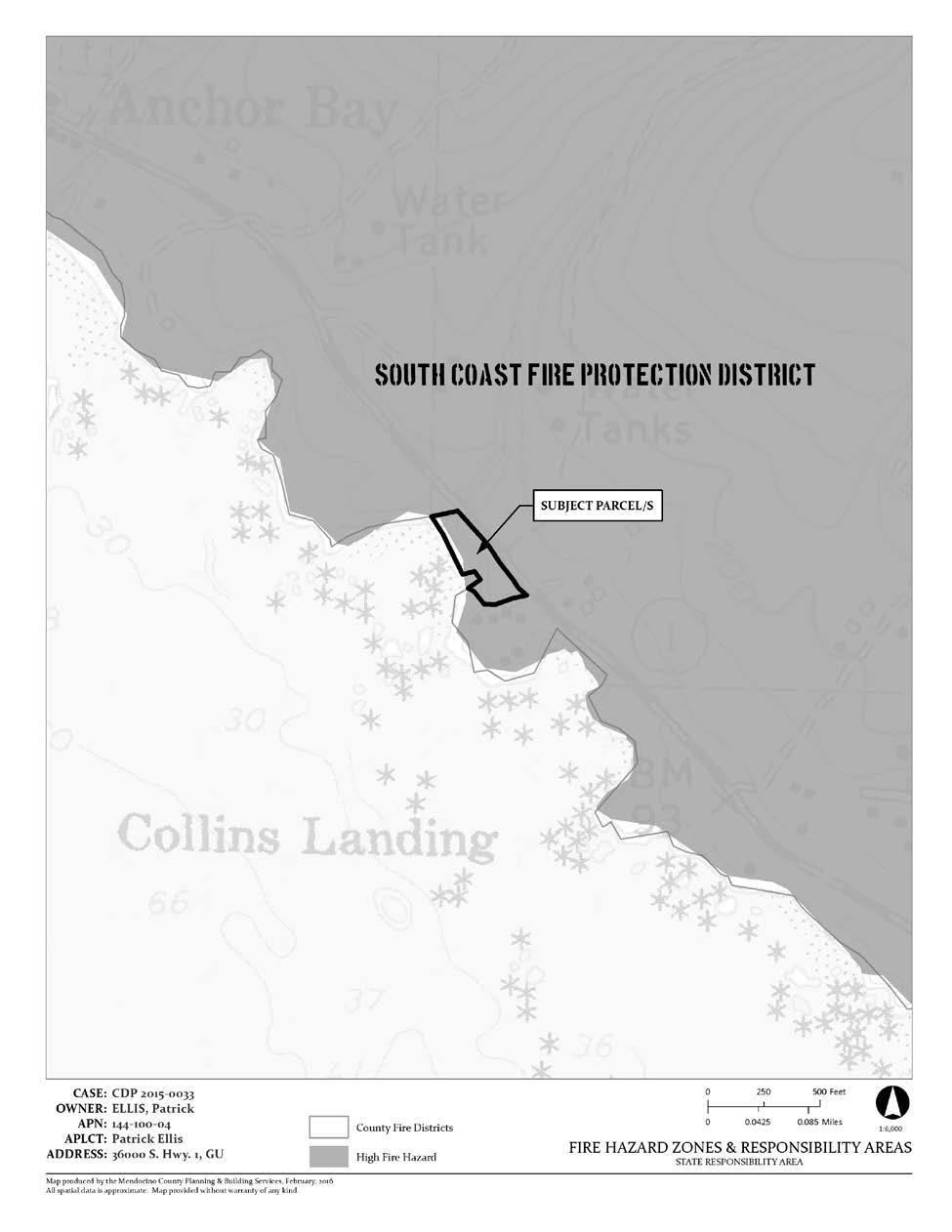
9 ATTACHMENT E
10 ATTACHMENT F
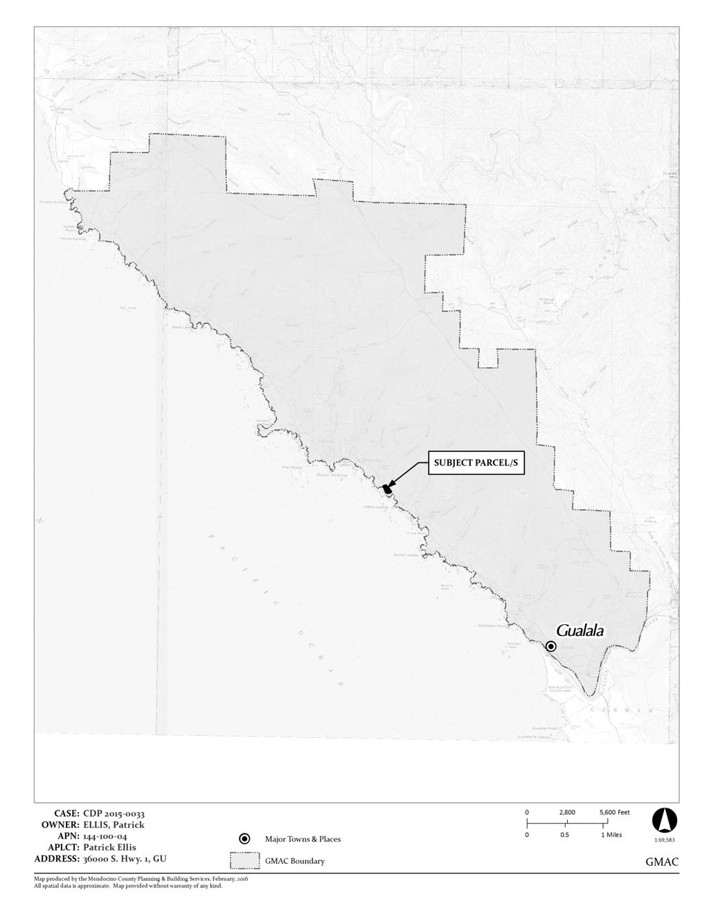
11 ATTACHMENT G
12 ATTACHMENT H
13 ATTACHMENT I
14 ATTACHMENT J
15 ATTACHMENT K
16 ATTACHMENT L
17 ATTACHMENT M
18 ATTACHMENT N
19 ATTACHMENT O
20 COASTAL PERMIT APPROVAL CHECKLIST OCTOBER 27, 2016 PROJECT TITLE: PROJECT LOCATION: LEAD AGENCY NAME, ADDRESS AND CONTACT PERSON: GENERAL PLAN DESIGNATION: ZONING DISTRICT CDP_ (Ellis/Lauer) S Hwy One Gualala, California APN: Juliana Cherry Mendocino County Planning and Building Services 120 West Fir Street Fort Bragg, California Mendocino County General Plan Coastal Element Rural Residential, 1-acre min. lot sizes RR5:R [RR-1] Mendocino County Coastal Zoning Code Division II Rural Residential, 1-acre min. lot sizes RR-5 DESCRIPTION OF PROJECT: A Coastal Development Standard Permit to repair and replace a leach field, pump tank, pump and control panel, and septic connecting lines. Minor trenching to bury the pump tank, connecting lines, and leach lines. Disturbed areas will be backfilled to original contours, seeded with native grasses, and or mulched. SITE DESCRIPTION AND SETTING: This developed 1.6-acre site is located 0.2 miles north of Highway 1 s intersection with Collins Landing Road, Gualala, California. At this site, a barn built in 1864 was converted to its current residential use during the s. The land is developed with a 1,090- square-foot single-family home (formerly a barn), shed, septic tank, pump basin, and leach field. The existing septic system has failed and the proposal is to repair the septic system. This is a bluff top parcel along Mendocino County s shoreline and is designated as a Highly Scenic Area. The site has been surveyed for environmentally sensitive habitat and other sensitive resources. Within 100-feet of the project area, no special status plants were identified. 1 Removal of trees during non-nesting season was recommended; and the trees situated within the project area were removed during the winter ( ), as the quantity and size of the trees did not constitute major vegetation removal. 2 A narrow drainage ditch directs water away from Highway 1 and across the parcel. This manmade, nontidal ditch does not constitute a wetland and is located north of the project area. 3 Local Coastal Plan Map 31 Gualala shows public access to the shore east of the subject site (a public access route is mapped along Highway 1). The project site falls within the appeal jurisdiction of the California Coastal Commission, because it is development along a coastal bluff. Mapping associates the following with the subject site: slope, High Fire Hazard Zone, Gualala Municipal Area Council, Critical Water Resources Bedrock, Highly Scenic Area, Western Soils #116, and FEMA flood zone. DETERMINATION: The proposed project can satisfy all required findings for approval of a Coastal Development Permit, pursuant to Sections and of the Mendocino County Coastal Zoning Code, as individually enumerated in this Coastal Permit Approval Checklist. 1 Letter from Spade Natural Resources Consulting, Fort Bragg. March 24, Letter from Spade Natural Resources Consulting, Fort Bragg. March 24, Memorandum prepared by Bill Maslach. August 7, Citing Appendix 8, Statewide Interpretive Guidelines, County of Mendocino Coastal Element, an exception to the definition of wetlands is outlined under 1(A). For the purposes of identifying wetlands using the technical criteria contained in this guideline, one limited exception will be made. That is, drainage ditches as defined herein will not be considered wetlands under the Coastal Act. A drainage ditch shall be defined as a narrow (usually less than 5-feet wide). Manmade nontidal ditch excavated from dry land.
21 COASTAL PERMIT APPROVAL CHECKLIST CDP PAGE Required Findings for All Coastal Development Permits (A) The granting or modification of any coastal development permit by the approving authority shall be supported by findings which establish the following: (1) The proposed development is in conformity with the certified local coastal program. (2) The proposed development will be provided with adequate utilities, access roads, drainage and other necessary facilities. (3) The proposed development is consistent with the purpose and intent of the zoning district applicable to the property, as well as the provisions of this Division and preserves the integrity of the zoning district. (4) The proposed development will not have any significant adverse impacts on the environment within the meaning of the California Environmental Quality Act. (5) The proposed development will not have any adverse impacts on any known archaeological or paleontological resource. (6) Other public services, including but not limited to, solid waste and public roadway capacity have been considered and are adequate to serve the proposed development. (B) If the proposed development is located between the first public road and the sea or the shoreline of any body of water, the following additional finding must be made: (1) The proposed development is in conformity with the public access and public recreation policies of Chapter 3 of the California Coastal Act and the Coastal Element of the General Plan. Inconsistent Consistent (With Conditions of Approval) Consistent (Without Conditions of Approval) Not Applicable (A)(1) The proposed development is in conformity with the certified local coastal program. Consistent (with conditions of approval) The Local Coastal Program (LCP) sets goals and policies for managing resource protection and development activity in the Coastal Zone of Mendocino County, an area that extends from the Humboldt County line to the Gualala River. The LCP addresses topics such as shoreline access and public trails; development in scenic areas, hazardous areas, and coastal bluff tops; environmentally sensitive habitat areas; cultural resources; transportation; public services; and more. The LCP serves as an element of the General Plan and includes the Mendocino County Coastal Zoning Code (MCC), and its policies must be consistent with the goals of the California Coastal Act. Various aspects of the LCP are specifically addressed by separate Required and Supplemental Findings for Coastal Development Permits, including utilities, transportation, zoning, California Environmental Quality Act (CEQA) consistency, archaeological resources, public services, coastal access, and resource protection. The following is a discussion of elements of the LCP not specifically addressed elsewhere in this checklist.
22 COASTAL PERMIT APPROVAL CHECKLIST CDP PAGE - 3 General Plan Land Use Rural Residential The subject parcel is classified as Rural Residential (RR) by the Coastal Element of the Mendocino County General Plan, which is intended to encourage local small scale food production (farming) in areas which are not well suited for large scale commercial agriculture [and] is not intended to be a growth area and residences should be located as to create minimal impact on agricultural viability. The principally permitted use designated for the RR land use classification is residential and associated utilities, light agriculture, [and] home occupation. The minimum parcel size for the RR land use classification is variable, as designated on the Land Use Map. 4 LCP Map 31 (Gualala) designates the minimum parcel size requirement as one acre. 5 The existing parcel density is conforming; pursuant to Section (A), the allowable density is one dwelling unit per forty thousand square feet. The lot is developed with an existing home and shed. The proposed septic repair, replacement leach field, pump tank, pump and control panel; and connecting lines are consistent with the RR classification of the Coastal Element of the Mendocino County General Plan and Mendocino County Code (MCC) Chapters Rural Residential District, Hazard Areas, Coastal Access Regulations and Open Space Easements, and Section Required Findings for all Coastal Development Permits. Hazards Mendocino County Coastal Element Chapter 3.4, titled Hazards Management, addresses seismic, geologic and natural forces within the Coastal Zone. MCC Chapter Hazard Areas include geologic hazards, such as MCC (A) Faults, (B) Bluffs, (C) Tsunami, (D) Landslides, and (E) Erosion. Mapping associates the following hazards with the subject site: High Fire Hazard Zone and portions of the land are situated within the FEMA flood zone. Seismic Activity and Faults: The San Andreas fault is a northwest trending, right lateral, strike-slip fault located 2.4 miles east of the project site, and is the closest recognized active fault to the site. The proposed project satisfies the siting and land use restrictions for faults, as delineated in MCC Section (A). Bluffs: The parcel is situated between State Route 1 and Mendocino County shoreline with coastal bluffs. MCC (B) lists specific development requirements for structural setbacks from the edges of bluffs to ensure their safety from bluff erosion and cliff retreat during the economic life span of the buildings. The proposal is to repair existing septic system. The replacement leach field and septic system will be installed at a greater distance from the bluff than existing development. The proposed project complies with MCC Section (B), as the existing land use and the risk associated with bluff top development is already established. PBS recommends a standard condition for projects adjacent to bluffs. Standard condition: Assumption of Risk, Waiver of Liability and Indemnity. By acceptance of this permit, the applicant acknowledges and agrees (a) that the site may be subject to hazards from bluff and slope instability, sea level rise, erosion, landslides and wave uprush or other tidal induced erosion; (b) to assume the risks to the applicant and the property that is the subject of this permit of injury and damage from such hazards in connection with this permitted development; (c) to unconditionally waive any claim of damage or inability against the County of Mendocino, its Coastal Permit Administrator, its officers, agents, and employees for injury or damage from such hazards; and (d) it indemnify and hold harmless the County of Mendocino, its officers, agents, and employees with respect to the Coastal Permit Administrator s approval of the project against any and all liability, claims, demands, damages, costs (including costs and fees incurred in defense of such claims), expenses, and amounts paid in settlement arising from any injury or damage due to such hazards. 4 Chapter 2.2. Mendocino County, Planning and Building Services, Planning Division. The County of Mendocino-General Plan Ukiah, CA. 5 Gualala [map] County of Mendocino Coastal Zone, Number 31 of 31. County of Mendocino Planning and Building. URL
23 COASTAL PERMIT APPROVAL CHECKLIST CDP PAGE - 4 Flooding, Tsunami, and Erosion: The northerly portion of the lot, which is not proposed for development, is mapped within the FEMA flood zone. 6 Wetlands were not observed within 100-feet of the project area. 7 The proposed project complies with MCC Section (C) Tsunami, (D) Flooding, and (E) Erosion, as the land use is existing and the potential for tsunami damage is not changed by repairing on-site septic systems. The risk of flooding on this parcel is north of the project area. The potential for impacts from erosion was established when the barn was constructed and later converted to a residential use. The project does not propose altering natural shoreline processes. 8 To ensure that soil erosion risk is limited, PBS recommends a standard condition that septic work to be conducted during the dry season. Standard condition: To ensure erosion does not occur as a result of the proposed septic system replacement, soil disturbance shall be conducted during the dry season (typically April to October) and erosion mix seeding and hay mulch shall be applied to all exposed soil associated with the development prior to the onset of the rainy season. Straw mulching shall be with clean straw (such as rice, barley, wheat or weed-free straw). Annual ryegrass (Festuca perennis) shall not be used. If excess fill remains after installation is shall be removed from the site and disposed of at an approved location. Plants or seed for landscaping and/or erosion control shall be native plants, or if nonnative, shall be non-invasive. No known invasive species shall be used; a list of invasive species is accessible at Fire: The parcel is located in an area characterized by a high fire-hazard severity rating. 9 March 30, 2016, comments were requested from California Department of Forestry and Fire Prevention (CalFire) and the South Coast Fire District. CalFire replied on April 6, 2016 that they had no comments at this time. No response was received from the South Coast Fire District. The project complies with MCC Section Fire Hazard - Development Standards as the new development (repair to on-site septic systems) is not anticipated to change the risk of fire at this location or surrounding lands. Visual Resources Protection of visual resources is a specific mandate of Section of the Coastal Act, and is subsequently addressed in Chapter 3.5 of General Plan s Coastal Element and implemented by MCC Chapter The subject parcel is located within a mapped Highly Scenic Area (HSA). 10 It is a developed site and the proposed repairs do not include above grade changes to the land. No impact to visual resources is anticipated. Natural Resources The site has been surveyed for environmentally sensitive habitat and other sensitive resources. Within 100-feet of the project area, no special status plants were identified. 11 Removal of trees during nonnesting season was recommended; and the trees situated within the project area were removed during the winter ( ), as the quantity and size of the trees did not constitute major vegetation removal. 12 A narrow drainage ditch directs water away from Highway 1 and across the parcel. This manmade, nontidal ditch does not constitute a wetland and is located north of the project area. 13 The 6 FEMA Flood Zone. NFIP Maps, June 2, See Staff Report Attachment FEMA Flood Zone. 7 Letter from Spade Natural Resources Consulting to Patrick Ellis and Lisa Lauer. Fort Bragg, CA. March 24, MCC Section (E) Erosion. 9 Fire Hazard Severity Zones in SRA [map] :150,000. Fire and Resource Assessment Program, California Department of Forestry and Fire Protection. 10 Mendocino County Coastal Zoning Code, II (1991). 11 Letter from Spade Natural Resources Consulting, Fort Bragg. March 24, Letter from Spade Natural Resources Consulting, Fort Bragg. March 24, Memorandum prepared by Bill Maslach. August 7, Citing Appendix 8, Statewide Interpretive Guidelines, County of Mendocino Coastal Element, an exception to the definition of wetlands is outlined under 1(A). For the purposes of identifying wetlands using the technical criteria contained in this guideline, one limited exception will be made. That is, drainage ditches as defined herein will not be considered wetlands under the Coastal Act. A drainage ditch shall be defined as a narrow (usually less than 5-feet wide). Manmade nontidal ditch excavated from dry land.
24 COASTAL PERMIT APPROVAL CHECKLIST CDP PAGE - 5 Department of Fish and Wildlife was contacted for comments on the project. They responded that trees should be removed outside of the nesting season (A)(2) The proposed development will be provided with adequate utilities, access roads, drainage and other necessary facilities. Consistent (without conditions of approval) Utilities The developed site currently includes a primary residence, shed, and driveway. The project requests approval to install a leach-field replacement area, which would be situated between the house and Highway 1. On May 30, 2016, PBS requested comments from the Department of Environmental Health. A response was received on April 7, 2016 that the staff recommended project approval. The leach-field replacement area would be subject to an Environmental Health Permit, which has been filed with the department and is awaiting concurrent approval of CDP Drainage A narrow drainage ditch directs water away from Highway 1 and across the parcel. This manmade, nontidal ditch does not constitute a wetland. 14 The proposed location for the leach field is south of a drainage-ditch and its contours roughly follow the adjacent roadway. Access Roads The parcel includes an existing driveway adjoining Highway 1. The proposed development is provided with adequate access roads (A)(3) The proposed development is consistent with the purpose and intent of the zoning district applicable to the property, as well as the provisions of this Division and preserves the integrity of the zoning district. Consistent (without conditions of approval) Intent: The subject parcel is zoned Rural Residential (RR). The intent of the RR zoning district is to encourage and preserve local small scale farming in the Coastal Zone on lands which are not well-suited for large scale commercial agriculture. Residential uses should be located as to create minimal impact on the agricultural viability. 15 The proposed replacement leach field and associated septic system repairs are consistent with supporting a residential land use at this site. 16 Use: The existing parcel is developed with a single-family residence and accessory structure, which is a principally permitted use in Mendocino County LCP Rural Residential Districts. Yards: The minimum required front, rear and side yards in the RR-5(1) zoning district are twenty, twenty, and six-feet, respectively. 17 The proposed site improvements meet or exceed building setback regulations. Height: The proposed development will occur at grade and would not exceed the height limitations of designated highly scenic areas. 14 Memorandum prepared by Bill Maslach. August 7, Citing Appendix 8, Statewide Interpretive Guidelines, County of Mendocino Coastal Element, an exception to the definition of wetlands is outlined under 1(A). For the purposes of identifying wetlands using the technical criteria contained in this guideline, one limited exception will be made. That is, drainage ditches as defined herein will not be considered wetlands under the Coastal Act. A drainage ditch shall be defined as a narrow (usually less than 5-feet wide). Manmade nontidal ditch excavated from dry land. 15 Mendocino County Coastal Zoning Code, II (1991). 16 Mendocino County Coastal Zoning Code, II (1991). 17 Mendocino County Coastal Zoning Code, II (1991).
25 COASTAL PERMIT APPROVAL CHECKLIST CDP PAGE - 6 Lot Coverage: The maximum permitted lot coverage in the RR zoning district for parcels less than two acres in size is twenty percent. The parcel is 1.6 acres, permitting maximum lot coverage of approximately 13,939 square feet. The sum of the proposed and existing development area on the parcel is approximately 1-percent of the lot area. The proposed development does not exceed the permitted lot coverage maximum for the Rural Residential District. Water: The project location is mapped as a Critical Water Resource Area. North Gualala Water Company provides sufficient potable water to the existing residence. No increase in water demand is associated with the proposal to repair on-site septic systems (A)(4) The proposed development will not have any significant adverse impacts on the environment within the meaning of the California Environmental Quality Act (CEQA). Consistent (without conditions of approval) PBS recommends a Class 4 Categorical Exemption from CEQA, pursuant with Guidelines Section 15304(F), for minor alterations of land, including minor trenching and backfilling where the surface is restored (A)(5) The proposed development will not have any adverse impacts on any known archaeological or paleontological resource. Consistent (with conditions of approval) The project site was referred to the Archaeological Commission for consideration on May 11, A site survey was requested and submitted on June 2, The Archaeological Commission considered the survey report at its July 13, 2016 meeting and accepted its findings that no cultural, historical or archaeological sites were observed. PBS recommends inclusion of a standard condition of project approval: Standard Condition: If any archaeological sites or artifacts are discovered during site excavation or construction activities, the applicant shall cease and desist from all further excavation and disturbances within one hundred (100) feet of the discovery, and make notification of the discovery to the Director of the Department of Planning and Building Services. The Director will coordinate further actions for the protection of the archaeological resources in accordance with Section of the Mendocino County Code (A)(6) Other public services, including but not limited to, solid waste and public roadway capacity have been considered and are adequate to serve the proposed development. Consistent (without conditions of approval) Solid Waste: The project site is located 5.8 miles south and west the South Coast Transfer Station (40855 Fish Rock Rd., Gualala) and if, the property owner chooses, they can participate in curbside pick-up of recyclables, waste, yard waste, and food and organic waste. Solid waste services are adequate. Roadway Capacity: The State Route 1 Corridor Study Update provides traffic volume data for State Highway 1. The subject property is located approximately 1.2-miles south of the intersection of Highway 1 and Fish Rock Road, which is the nearest data point in the corridor study. Intersection Level of Service is considered Level of Service B. 18 The proposed septic system repair and replacement leach-field area will generate few additional vehicle trips per day. No change in service levels is anticipated. 18 State Route 1 Corridor Study Update for the County of Mendocino. Rep. Santa Rosa: Whitlock & Weinberger Transportation, Print. URL
26 COASTAL PERMIT APPROVAL CHECKLIST CDP PAGE (B)(1) If the proposed Development is located between the first public road and the sea or the shoreline of any body of water, the following additional finding must be made: The proposed development is in conformity with the public access and public recreation policies of Chapter 3 of the California Coastal Act and the Coastal Element of the General Plan. Consistent (without conditions of approval) The project site is located west of Highway 1. The Coastal Element of the General Plan designates this section of the highway as the public access route to the county s coastline. There is no evidence of prescriptive access on the developed site. The project would have no effect on public access to the coast.
27 Resolution Number County of Mendocino Ukiah, California October 27, 2016 CDP_ ELLIS RESOLUTION OF THE COASTAL PERMIT ADMINISTRATOR, COUNTY OF MENDOCINO, STATE OF CALIFORNIA, ADOPTING A CATEGORICAL EXEMPTION FROM CEQA AND GRANTING A COASTAL DEVELOPMENT STANDARD PERMIT FOR A REPLACEMENT LEACH FIELD AREA AND OTHERS WHEREAS, the applicant, Patrick Ellis and Lisa Lauer, filed an application for a Coastal Development Standard Permit with the Mendocino County Department of Planning and Building Services to repair and replace a leach field, pump tank, pump and control panel, and septic connecting lines; remove three 18-inch diameter trees; and trench and bury the pump tank, connect lines, and leach lines; and backfill disturbed areas to original contours, seed with native grasses or mulch. The site is located on the west side of Highway 1 approximately 0.2 miles north of its intersection with Collins Landing Road or 2.5 miles north of Gualala South Highway 1, Gualala; APN ; General Plan RR5:R; Zoning RR:5; Supervisorial District 5; (the Project ); and WHEREAS, a categorical exemption was prepared for the Project and noticed and made available for agency and public review on August 22, 2016 in accordance with the California Environmental Quality Act (CEQA) and the State and County CEQA Guidelines; and WHEREAS, in accordance with applicable provisions of law, the Coastal Permit Administrator held a public hearing on, October 27, 2016, at which time the Coastal Permit Administrator heard and received all relevant testimony and evidence presented orally or in writing regarding the categorical exemption from CEQA and the Project. All interested persons were given an opportunity to hear and be heard regarding the categorical exemption from CEQA and the Project; and WHEREAS, the Coastal Permit Administrator has had an opportunity to review this Resolution and finds that it accurately sets for the intentions of the Coastal Permit Administrator regarding the categorical exemption from CEQA and the Project. NOW, THEREFORE, BE IT RESOLVED, that the Coastal Permit Administrator makes the following findings: 1. The existing single-family home is a permitted use within the RR land use classification and the proposed septic repairs (replacement leach field, pump tank, pump and control panel, and connecting lines) are commonly associated with residential accessory uses. 2. The parcel has demonstrated sufficient access to utilities, access roads, drainage, and other necessary facilities. 3. The proposed project complies with the development standards of Mendocino County Codes and the Rural Residential District, including standards for development in Highly Scenic Areas and lands subject to geologic, fire, and flood hazards. 4. The project area has been surveyed for special status plants and no significant impact to environmentally sensitive areas or other resources is anticipated. The project is suited to a Categorical Exemption from CEQA. 5. The property has been surveyed for archaeological resources and none has been found. Mendocino County Archaeological Commission has accepted the application and survey. REVISED RESOLUTION CDP_ Ellis, 9/26/ :25 AM Page 1
28 6. No change in the Level of Service at the intersection of Fish Rock Road and State Route 1 is anticipated and disposal of solid waste is available within three miles of the project location. 7. Coastal access is provided for along State Route 1. The proposed septic system repair does not diminish public access to Mendocino County coastal areas and conforms to the goals and policies of the Coastal Element of the General Plan. BE IT FURTHER RESOLVED that the Coastal Permit Administrator hereby adopts a Class 4 Categorical Exemption from CEQA, for minor alterations of land, including minor trenching and backfilling where the surface is restored. The Coastal Permit Administrator certifies that the categorical exemption from CEQA has been completed, reviewed, and considered, together with the comments received during the public review process, in compliance with CEQA and State and County CEQA Guidelines, and finds that pursuant with Section 15304(F), a Class 4 Categorical Exemption from CEQA reflects the independent judgment and analysis of the Coastal Permit Administrator. BE IT FURTHER RESOLVED that the Coastal Permit Administrator hereby grants the requested Coastal Development Standard Permit, subject to the Conditions of Approval in Exhibit A, attached hereto. BE IT FURTHER RESOLVED that the Coastal Permit Administrator designates the Secretary as the custodian of the document and other material that constitutes the record of proceedings upon which the Coastal Permit Administrator decision herein is based. These documents may be found at the office of the County of Mendocino Planning and Building Services, 860 North Bush Street, Ukiah, CA BE IT FURTHER RESOLVED that the Coastal Permit Administrator action shall be final on the 11 th day after the date of the Resolution unless an appeal is taken. I hereby certify that according to the Provisions of Government Code Section delivery of this document has been made. ATTEST: ADRIENNE THOMPSON Commission Services Supervisor By: BY: STEVE DUNNICLIFF Director ANDY GUSTAVSON Coastal Permit Administrator REVISED RESOLUTION CDP_ Ellis, 9/26/ :25 AM Page 2
29 EXHIBIT A CONDITIONS OF APPROVAL CDP_ OCTOBER 27, 2016 A Coastal Development Permit to repair and replace a leach field, pump tank, pump and control panel, and septic connecting lines. Minor trenching to bury the pump tank, connecting lines, and leach lines. Disturbed areas will be backfilled to original contours, seeded with native grasses, and or mulched. APPROVED PROJECT DESCRIPTION: A Coastal Development Permit to repair and replace a leach field, pump tank, pump and control panel, and septic connecting line. Minor trenching to bury the pump tank, connecting lines, and leach lines. Disturbed areas will be backfilled to original contours, seeded with native grasses, and or mulched. CONDITIONS OF APPROVAL: 1. This action shall become final on the 11th day following the decision unless an appeal is filed pursuant to Section of the Mendocino County Code. The permit shall become effective after the ten (10) working day appeal period to the Coastal Commission has expired and no appeal has been filed with the Coastal Commission. The permit shall expire and become null and void at the expiration of two years after the effective date except where construction and use of the property in reliance on such permit has been initiated prior to its expiration. To remain valid, progress towards completion of the project must be continuous. The applicant has sole responsibility for renewing this application before the expiration date. The County will not provide a notice prior to the expiration date. 2. The use and occupancy of the premises shall be established and maintained in conformance with the provisions of Division II of Title 20 of the Mendocino County Code. 3. The application, along with supplemental exhibits and related material, shall be considered elements of this permit, and that compliance therewith is mandatory, unless an amendment has been approved by the Coastal Permit Administrator. 4. That this permit be subject to the securing of all necessary permits for the proposed development from County, State and Federal agencies having jurisdiction. 5. The applicant shall secure all required building permits for the proposed project as required by the Building Inspection Division of the Department of Planning and Building Services. 6. This permit shall be subject to revocation or modification upon a finding of any one (1) or more of the following: a. That such permit was obtained or extended by fraud. b. That one or more of the conditions upon which such permit was granted have been violated. c. That the use for which the permit was granted is so conducted as to be detrimental to the public health, welfare or safety or as to be a nuisance. d. A final judgment of a court of competent jurisdiction has declared one or more conditions to be void or ineffective, or has enjoined or otherwise prohibited the enforcement or operation of one or more such conditions. 7. This permit is issued without a legal determination having been made upon the number, size or shape of parcels encompassed within the permit described boundaries. Should, at any time, a legal determination be made that the number, size or shape of parcels within the permit described boundaries are different than that which is legally required by this permit, this permit shall become null and void. REVISED RESOLUTION CDP_ Ellis, 9/26/ :25 AM Page 3
30 8. If any archaeological sites or artifacts are discovered during site excavation or construction activities, the applicant shall cease and desist from all further excavation and disturbances within one hundred (100) feet of the discovery, and make notification of the discovery to the Director of the Department of Planning and Building Services. The Director will coordinate further actions for the protection of the archaeological resources in accordance with Section of the Mendocino County Code. 9. Assumption of Risk, Waiver of Liability and Indemnity. By acceptance of this permit, the applicant acknowledges and agrees (a) that the site may be subject to hazards from bluff and slope instability, sea level rise, erosion, landslides and wave uprush or other tidal induced erosion; (b) to assume the risks to the applicant and the property that is the subject of this permit of injury and damage from such hazards in connection with this permitted development; (c) to unconditionally waive any claim of damage or inability against the County of Mendocino, its Coastal Permit Administrator, its officers, agents, and employees for injury or damage from such hazards; and (d) it indemnify and hold harmless the County of Mendocino, its officers, agents, and employees with respect to the Coastal Permit Administrator s approval of the project against any and all liability, claims, demands, damages, costs (including costs and fees incurred in defense of such claims), expenses, and amounts paid in settlement arising from any injury or damage due to such hazards. 10. To ensure erosion does not occur as a result of the proposed septic system replacement, soil disturbance shall be conducted during the dry season (typically April to October) and erosion mix seeding and hay mulch shall be applied to all exposed soil associated with the development prior to the onset of the rainy season. Straw mulching shall be with clean straw (such as rice, barley, wheat or weed-fee straw). Annual ryegrass (Festuca perennis) shall not be used. If excess fill remains after installation is shall be removed from the site and disposed of at an approved location. Plants or seed for landscaping and/or erosion control shall be native plants, or if non-native, shall be non-invasive. No known invasive species shall be used; a list of invasive species is accessible at REVISED RESOLUTION CDP_ Ellis, 9/26/ :25 AM Page 4
STAFF REPORT FOR STANDARD COASTAL DEVELOPMENT PERMIT #CDP FEBRUARY 26, 2015 CPA - 1 PO BOX 238 APTOS, CA 94001
 STAFF REPORT FOR STANDARD COASTAL DEVELOPMENT PERMIT #CDP 2014-0030 FEBRUARY 26, 2015 CPA - 1 OWNER/APPLICANT: AGENT: REQUEST: HANS HEIM PO BOX 238 APTOS, CA 94001 JAMES HAY PO BOX 762 MENDOCINO, CA 95460
Coastal Permit Administrator 4/27/2017
 Coastal Permit Administrator 4/27/2017 STAFF REPORT- CDP_STANDARD CDP_2014-0027 SUMMARY OWNER/APPLICANT: AGENT: REQUEST: TAMMY BRAY, TERRY BRAY 5959 HIGHWAY 175 HOPLAND, CA 95449 WYNN COASTAL PLANNING
STAFF REPORT JULY 26, 2017
 COASTAL PERMIT ADMINISTRATOR STAFF REPORT JULY 26, 2017 SUMMARY OWNER/APPLICANT: AGENT: REQUEST: DALE SPRING AND PATRICIA ARNETT 1121 BOONVILLE RD UKIAH, CA 95482 KELLY GRIMES PO BOX 598 LITTLE RIVER,
COASTAL PERMIT ADMINISTRATOR DECEMBER 16, 2015 STAFF REPORT/COASTAL DEVELOPMENT PERMIT
 COASTAL PERMIT ADMINISTRATOR DECEMBER 16, 2015 STAFF REPORT/COASTAL DEVELOPMENT PERMIT CDP_2013-0012 OWNER/APPLICANT: AGENT: REQUEST: LOCATION: APPEALABLE: PERMIT TYPE: SYDNEY MINTZ & JUSTINE SHAPIRO 336
COASTAL PERMIT ADMINISTRATOR DECEMBER 14, 2016
 COASTAL PERMIT ADMINISTRATOR DECEMBER 14, 2016 STAFF REPORT- CDP_STANDARD CDP_2016-0009 SUMMARY OWNERS: JOHN ARJAY RAFFETY 13214 FIJI WAY UNIT A MARINA DEL REY, CA 90292 KERRY HEISE, ADINA MERENLENDER
STAFF REPORT FOR COASTAL DEVELOPMENT CDP# ADMINISTRATIVE PERMIT SEPTEMBER 9, 2014 BOS PRESSLEY ROAD SANTA ROSA, CA 95404
 SEPTEMBER 9, 2014 BOS-1 OWNER/APPLICANT: REQUEST: DAVID DERUITER 4714 PRESSLEY ROAD SANTA ROSA, CA 95404 Coastal Development Permit for a single family residence, barn, guest cottage, driveway and related
-MENDOCINO COUNTY PLANNING AND BUILDING SERVICES- DIVISION II OF TITLE 20--COASTAL ZONING CODE
 CHAPTER 20.504 VISUAL RESOURCE AND SPECIAL TREATMENT AREAS Sec. 20.504.005 Applicability. Sec. 20.504.010 Purpose. Sec. 20.504.015 Highly Scenic Areas. Sec. 20.504.020 Special Communities and Neighborhoods.
COUNTY OF EL DORADO DEVELOPMENT SERVICES PLANNING COMMISSION STAFF REPORT SPECIAL USE PERMIT
 COUNTY OF EL DORADO DEVELOPMENT SERVICES PLANNING COMMISSION STAFF REPORT Agenda of: November 14, 2013 Item No.: 8.c Staff: Aaron Mount SPECIAL USE PERMIT FILE NUMBER: APPLICANT: REQUEST: LOCATION: Sandra
THE CITY COUNCIL OF THE CITY OF SAN JUAN BAUTISTA DOES HEREBY ORDAIN AS FOLLOWS:
 ORDINANCE NO. 2016 01 AN ORDINANCE OF THE CITY OF SAN JUAN BAUTISTA AMENDING THE SAN JUAN BAUTISTA MUNICIPAL CODE TO ADD CHAPTER 11-08 HILLSIDE DEVELOPMENT REGULATIONS WHEREAS, the City Council has reviewed
TOWNSHIP OF LOGAN SOIL & FILL IMPORTATION AND PLACEMENT APPLICATION SUBMITTAL CHECKLIST
 TOWNSHIP OF LOGAN SOIL & FILL IMPORTATION AND PLACEMENT APPLICATION SUBMITTAL CHECKLIST Applications: 5 copies of application - Applicant will reproduce the copies at his/her costs. The Township Clerk
PC RESOLUTION NO
 PC RESOLUTION NO. 14-01-14-02 TENTATIVE TRACT MAP fttm) 17441. REZONE {RZ) 13-003, ARCHITECTURAL CONTROL (AC) 13-003, TREE REMOVAL PERMIT (TRP) 13-052. GRADING PLAN MODIFICATION (GPM) 13-002. CONDITIONAL
ORDINANCE NO WHEREAS, the City of Kalama has many areas of timberland and open areas inside its City limits adjacent to residential areas;
 ORDINANCE NO. 1342 AN ORDINANCE OF THE CITY OF KALAMA, WASHINGTON ADOPTING A NEW KALAMA MUNICIPAL CODE CHAPTER 17.20 ESTATE LOT FLOATING ZONE TO PROVIDE TRANSITIONAL ZONING OPTIONS FOR RESIDENTIAL DEVELOPMENT
Town of Florence Florence County, WI DRIVEWAY ORDINANCE
 Town of Florence Florence County, WI 08-10-09 DRIVEWAY ORDINANCE 1.01 PURPOSE The purpose of this Ordinance is to regulate the establishment, construction, improvement, modification or reworking of a driveway
PLANNED DEVELOPMENT (MASTER PLAN & UNIT PLAN)
") Central Permit Center 555 Santa Clara Street Vallejo CA 94590 Business License Building Fire Prevention Planning Public Works 707.648.4310 707.648.4374 707.648.4565 707.648.4326 707.651.7151 PLANNED DEVELOPMENT
Central Permit Center 555 Santa Clara Street Vallejo CA 94590 Business License Building Fire Prevention Planning Public Works 707.648.4310 707.648.4374 707.648.4565 707.648.4326 707.651.7151 PLANNED DEVELOPMENT
COUNTY COUNCIL OF PRINCE GEORGE'S COUNTY, MARYLAND SITTING AS THE DISTRICT COUNCIL 2010 Legislative Session. Council Members Dernoga and Olson
 DR- COUNTY COUNCIL OF PRINCE GEORGE'S COUNTY, MARYLAND SITTING AS THE DISTRICT COUNCIL 00 Legislative Session Bill No. CB--00 Chapter No. Proposed and Presented by Introduced by Co-Sponsors The Chairman
CITY OF MALIBU PLANNING COMMISSION RESOLUTION NO
 CITY OF MALIBU PLANNING COMMISSION RESOLUTION NO. 16-54 A RESOLUTION OF THE PLANNING COMMISSION OF THE CITY OF MALIBU, CONSIDERING AN ADDENDUM TO THE CERTIFIED CRUMMER SITE SUBDIVISION FINAL EIR AND MAKING
COUNTY OF SANTA CRUZ MEMORANDUM. To: Don Bussey, Zoning Administrator From: Lawrence Kasparowitz, Project Planner
 1 - COUNTY OF SANTA CRUZ I MEMORANDUM Date: June 21,2006 To: Don Bussey, Zoning Administrator From: Lawrence Kasparowitz, Project Planner Re: 02-0432 Agenda Date: July 21, 2006 Agenda Item #: 0.1 Time:
Town of Excelsior, Sauk County, Wisconsin DRIVEWAY ORDINANCE
 Town of Excelsior, Sauk County, Wisconsin DRIVEWAY ORDINANCE 1.01 PURPOSE The purpose of this ordinance is to regulate the establishment, construction, improvement, modification or reworking of a driveway
DRIVEWAY REGULATIONS
 TOWN OF NEW LONDON PLANNING BOARD DRIVEWAY REGULATIONS INSTRUCTIONS TO APPLICANTS FOR THE CONSTRUCTION OR ALTERATION OF DRIVEWAYS IMPORTANT: READ CAREFULLY BEFORE FILLING OUT ATTACHED APPLICATION Revised
MARIN COUNTY COMMUNITY DEVELOPMENT AGENCY
 MARIN COUNTY COMMUNITY DEVELOPMENT AGENCY ALEX HINDS, DIRECTOR STAFF REPORT TO THE PLANNING COMMISSION Dwaileebe Coastal Permit and Design Review Clearance Item No: 5 Application No: CP 07-10 & DC 07-26
REPORT TO PLANNING AND DESIGN COMMISSION City of Sacramento
 REPORT TO PLANNING AND DESIGN COMMISSION City of Sacramento 5 PUBLIC HEARING June 12, 2014 To: Members of the Planning and Design Commission Subject: Newman Center Sign (P14-017) A request to construct
Appendix G Response to Comments
 Appendix G Response to Comments This appendix contains the comments received during the public circulation and comment period (May 27, 2008 to July 11, 2008). The comments have been numbered (Comment Set
CITY OF VACAVILLE PLANNING COMMISSION Agenda Item No. G.3 STAFF REPORT August 18, 2015 Staff Contact: Peyman Behvand (707)
") CITY OF VACAVILLE PLANNING COMMISSION Agenda Item No. G.3 STAFF REPORT August 18, 2015 Staff Contact: Peyman Behvand (707) 449-5140 TITLE: REQUEST: VISTA CROSSINGS PLANNED SIGN PROGRAM AMENDMENT PLANNED
CITY OF VACAVILLE PLANNING COMMISSION Agenda Item No. G.3 STAFF REPORT August 18, 2015 Staff Contact: Peyman Behvand (707) 449-5140 TITLE: REQUEST: VISTA CROSSINGS PLANNED SIGN PROGRAM AMENDMENT PLANNED
ARTICLE VI: SITE PLAN REVIEW
 Section 6.01 - Site Plan Review (All Districts) ARTICLE VI: SITE PLAN REVIEW Site plans give the Planning commission an opportunity to review development proposals in a concise and consistent manner. The
ARTICLE 17 SITE PLAN REVIEW
 ARTICLE 17 SITE PLAN REVIEW 17.01 INTENT AND PURPOSE The intent of this section is to provide for consultation and cooperation between the applicant and the township planning commission so that the applicant
Chesapeake Bay Critical Area Conservation Plan
 The Maryland-National Capital Park and Planning Commission Prince George s County Planning Department Development Review Division 301-952-3530 Note: Staff reports can be accessed at www.mncppc.org/pgco/planning/plan.htm.
At Your Disposal CUP Amendment, Lot 20, Village Service Commercial, at 128 Bastille Dr. (PLN17-208)
") MEMORANDUM Archuleta County Development Services Planning Department 1122 HWY 84 P. O. Box 1507 Pagosa Springs, Colorado 81147 970-264-1390 Fax 970-264-3338 TO: Archuleta County Planning Commission FROM:
MEMORANDUM Archuleta County Development Services Planning Department 1122 HWY 84 P. O. Box 1507 Pagosa Springs, Colorado 81147 970-264-1390 Fax 970-264-3338 TO: Archuleta County Planning Commission FROM:
Glenborough at Easton Land Use Master Plan
 Implementation 114 9.0 IMPLEMENTATION 9.1 OVERVIEW This chapter summarizes the administrative procedures necessary to implement the proposed land use plan, infrastructure improvements, development standards,
ARTICLE IV: DEVELOPMENT STANDARDS 404 MASTER PLANNING
 IV 13 404 MASTER PLANNING Master Planning through the Site Analysis (Master Planning Site Analysis) or Planned Development (Master Planning Planned Development) is provided to encourage development which
Project phasing plan (if applicable) 12 copies of site plan
 12 copies of site plan") SITE PLAN REVIEW PERMIT APPLICATION City of Grand Haven, 11 N. Sixth Street, Grand Haven, MI 49417 Phone: (616) 847-3490 Fax: (616) 844-2051 Website: www.grandhaven.org 1. Project Information Address/location
SITE PLAN REVIEW PERMIT APPLICATION City of Grand Haven, 11 N. Sixth Street, Grand Haven, MI 49417 Phone: (616) 847-3490 Fax: (616) 844-2051 Website: www.grandhaven.org 1. Project Information Address/location
SECTION 1 CLEARING /GRADING PERMIT APPLICATION:
 PLEASE REFER TO THE CLEARING & GRADING PERMIT CHECKLIST BELOW FOR SUBMITTAL REQUIREMENTS. SECTION 1 CLEARING /GRADING PERMIT APPLICATION: PROJECT ADDRESS (Street, Suite #): Parcel(s) #: Total Site Area
CITY OF VACAVILLE PLANNING COMMISSION Agenda Item No. G. 1 STAFF REPORT August 4, Staff Contact: Tricia Shortridge (707)
") CITY OF VACAVILLE PLANNING COMMISSION Agenda Item No. G. 1 STAFF REPORT August 4, 2009 Staff Contact: Tricia Shortridge (707) 449-5140 TITLE: REQUEST: LONGS / CVS DRIVE-THRU PHARMACY & REMODEL TIME EXTENSION
CITY OF VACAVILLE PLANNING COMMISSION Agenda Item No. G. 1 STAFF REPORT August 4, 2009 Staff Contact: Tricia Shortridge (707) 449-5140 TITLE: REQUEST: LONGS / CVS DRIVE-THRU PHARMACY & REMODEL TIME EXTENSION
CLACKAMAS COUNTY ZONING AND DEVELOPMENT ORDINANCE
 704 RIVER AND STREAM CONSERVATION AREA (RSCA) 704.01 PURPOSE Section 704 is adopted to: A. Maintain the integrity of the rivers and streams in the County by minimizing erosion, promoting bank stability,
ARTICLE IX SPECIAL PERMIT USES
 ARTICLE IX SPECIAL PERMIT USES All special permit uses cited in Article IX and Attachment A of this Ordinance or any other Section of this Ordinance shall be subject to Site Plan Review. The procedures
City of Fort Lupton Site Plan Process
 Form WKBK001 City of Fort Lupton Site Plan Process Purpose The Site Plan process is meant to promote orderly and sound development standards as they apply to the City. These site development standards
CITY OF LAGUNA BEACH COMMUNITY DEVELOPMENT DEPARTMENT STAFF REPORT DESIGN REVIEW BOARD IBOARD OF ADJUSTMENT Coast Highway APN
 CITY OF LAGUNA BEACH COMMUNITY DEVELOPMENT DEPARTMENT STAFF REPORT HEARING DATE: October 13,2011 TO: DESIGN REVIEW BOARD IBOARD OF ADJUSTMENT CASE: Variance 7717 Design Review 11-163 Coastal Development
CITY OF CYPRESS 5275 Orange Avenue Cypress, California (714) DESIGN REVIEW COMMITTEE PERMIT PROCESS
 DESIGN REVIEW COMMITTEE PERMIT PROCESS") CITY OF CYPRESS 5275 Orange Avenue Cypress, California 90630 (714) 229-6720 DESIGN REVIEW COMMITTEE PERMIT PROCESS 1. Discuss project with Planning staff to determine zoning regulations, any unusual characteristics
CITY OF CYPRESS 5275 Orange Avenue Cypress, California 90630 (714) 229-6720 DESIGN REVIEW COMMITTEE PERMIT PROCESS 1. Discuss project with Planning staff to determine zoning regulations, any unusual characteristics
COUNTY OF RIVERSIDE PLANNING DEPARTMENT STAFF REPORT
 Agenda Item No.: 5.4 Area Map: Jurupa Zoning District: Prado-Mira Loma Supervisorial District: Second Project Planner: Christian Hinojosa Planning Commission: February 3, 2010 Conditional Use Permit No.
ELIGIBILITY CRITERIA CHECKLIST OPEN SPACE CLASSIFICATION
 THURSTON COUNTY DEVELOPMENT SERVICES OPEN SPACE TAX PROGRAM ELIGIBILITY CRITERIA CHECKLIST OPEN SPACE CLASSIFICATION Use this checklist to help you determine whether your property is eligible for open
ORDINANCE NO. 430 REGARDING WATER CONSERVATION
 ORDINANCE NO. XXXX AN ORDINANCE OF THE TOWN COUNCIL OF THE TOWN OF TIBURON AMENDING TITLE IV, CHAPTER 13E (WATER EFFICIENT LANDSCAPE) OF THE MUNICIPAL CODE AND ADOPTING BY REFERENCE MARIN MUNICIPAL WATER
ARTICLE 3. LARGE-SCALE SOLAR PHOTOVOLTAIC INSTALLATIONS SECTION XXI
 ARTICLE 3. LARGE-SCALE SOLAR PHOTOVOLTAIC INSTALLATIONS SECTION XXI 1.1 PURPOSE The purpose of this by-law is to regulate the installation of solar photovoltaic installations that are to produce 250 kw
A BILL FOR AN ORDINANCE TO AMEND CHAPTER 9, KAUAI COUNTY CODE 1987, RELATING TO STREET REQUIRE:MENTS FOR SUBDIVISIONS
 ORDINANCE NO. BILL NO. { vy"yj1j A BILL FOR AN ORDINANCE TO AMEND CHAPTER 9, KAUAI COUNTY CODE 1987, RELATING TO STREET REQUIRE:MENTS FOR SUBDIVISIONS BE IT ORDAINED BY THE COUNCIL OF THE COUNTY OF KAUA'I,
City of Fort Lupton Administrative Site Plan Process
 City of Fort Lupton Administrative Site Plan Process Purpose The Site Plan process is meant to promote orderly and sound development standards as they apply to the City. These site development standards
ADDENDUM TO BIOLOGICAL SCOPING SURVEY REPORT, BOTANICAL SURVEY AND WETLAND DELINEATION
 ADDENDUM TO BIOLOGICAL SCOPING SURVEY REPORT, BOTANICAL SURVEY AND WETLAND DELINEATION FOR AVALON INN (APN 069-241-27 & -04) 1201 & 1211 NORTH MAIN STREET FORT BRAGG, CA MENDOCINO COUNTY prepared for:
CITY OF LOCKPORT FIRE SPRINKLER & FIRE ALARM SYSTEM INSTALLATION ASSISTANCE PROGRAM
 CITY OF LOCKPORT FIRE SPRINKLER & FIRE ALARM SYSTEM INSTALLATION ASSISTANCE PROGRAM The City of Lockport has implemented a Fire Sprinkler & Fire Alarm System Installation Assistance Program for eligible
Design Review Commission Report
 City of Beverly Hills Planning Division 455 N. Rexford Drive Beverly Hills, CA 90210 TEL. (310) 285-1141 FAX. (310) 858-5966 Design Review Commission Report Meeting Date: Thursday, March 2, 2017 Subject:
DESIGN REVIEW COMMITTEE AGENDA ITEM
 DESIGN REVIEW COMMITTEE AGENDA ITEM AGENDA DATE: DECEMBER 16, 2015 TO: THRU: FROM: SUBJECT: Chair McCormick and Members of the Design Review Committee Leslie Aranda Roseberry, Planning Manager Kelly Christensen
CHAPTER 4 - LAND USE CLASSIFICATIONS
 CHAPTER 4 - LAND USE CLASSIFICATIONS Four new land use classification categories are established in the Gualala Town Plan: Gualala Village Mixed Use; Gualala Highway Mixed Use; Gualala Planned Development
CITY OF SCANDIA ORDINANCE NO. 174
 CITY OF SCANDIA ORDINANCE NO. 174 AN ORDINANCE AMENDING ORDINANCE NO. 122, THE SCANDIA DEVELOPMENT CODE, CHAPTER 2, SECTION 4.34, REGARDING SOLAR FARMS AND COMMUNITY SOLAR GARDENS The City Council of the
Article 3: Police Regulated Occupations and Businesses. Division 37: Burglary, Robbery and Emergency Alarm Systems
 Article 3: Police Regulated Occupations and Businesses Division 37: Burglary, Robbery and Emergency Alarm Systems 33.3701 Definitions Defined words appear in italics. Except as otherwise provided, for
C-I-10. The effect of establishing a comprehensive site review as follows will: B. Reduce the cluttered aspects of current development by:
 C-I-10 PART C SECTION I ARTICLE 10 GENERAL REGULATIONS PROJECT SITE REVIEW I. Purpose The effect of establishing a comprehensive site review as follows will: A. Protect streetscapes from projects that
CITY OF ZEELAND PLANNING COMMISSION
 APPLICATION FOR SITE PLAN REVIEW AND SPECIAL LAND USE Date City Official App. Filing Fee Rec'd ($350) NOTE TO APPLICANT: Please submit this application for Site Plan Review along with twenty (20) copies
Neo-Traditional Overlay Application
 MAYOR AND CITY COUNCIL OF LAUREL DEPARTMENT OF ECONOMIC AND COMMUNITY DEVELOPMENT 8103 Sandy Spring Road Laurel, Maryland 20707 (301) 725-5300 Internet Address http://www.cityoflaurel.org E-mail: ecd@laurel.md.us
The Town Board of the Town of Vienna, County of Dane, State of Wisconsin, does ordain and adopt as follows.
 ORDINANCE DRIVEWAYS AND CULVERTS NO. 6-5-06 ORDINANCE CONCERNING DRIVEWAY AND CULVERT REQUIREMENTS 1-1-1 Driveway Permits; Culvert Requirements 1-1-2 Driveway and Culvert Location, Design and Construction
Ephrata Municipal Code, Chapter 19.07, Landscaping Regulations DRAFT January 28, 2013 Page 1
 Chapter 19.07 LANDSCAPING REGULATIONS Sections: 19.07.010 Purpose. 19.07.020 Landscape plan approval. 19.07.030 Failure to complete required landscaping Inspection. 19.07.040 General landscape requirements
Major Subdivision Sketch Plan Checklist
 This checklist provides specific requirements that are apart of the Sketch process. The entire process is described by the Huntersville Subdivision Review Process which details all the submittal and resubmittal
Exhibit A. 8:9 Scuffletown Rural Conservation District
 Exhibit A 8:9 Scuffletown Rural Conservation District 8:9.1 Intent and Purpose The Scuffletown Rural Conservation (SRC) District is intended to provide for residential development that supports the development
CITY OF ST. AUGUSTA STEARNS COUNTY MINNESOTA ORDIANCE NO AN ORDINANCE ESTABLISHING REGULATIONS FOR STORMWATER MANAGEMENT
 CITY OF ST. AUGUSTA STEARNS COUNTY MINNESOTA ORDIANCE NO. 2017-05 AN ORDINANCE ESTABLISHING REGULATIONS FOR STORMWATER MANAGEMENT In the interest of the health, safety, and welfare of its citizens, the
AWH REPORT OF THE PLANNING AND DEVELOPMENT DEPARTMENT FOR APPLICATION FOR REZONING ORDINANCE TO PLANNED UNIT DEVELOPMENT
 AWH REPORT OF THE PLANNING AND DEVELOPMENT DEPARTMENT FOR APPLICATION FOR REZONING ORDINANCE TO PLANNED UNIT DEVELOPMENT MAY 8, 2014 The Planning and Development Department hereby forwards to the Planning
CITY OF VACAVILLE PLANNING COMMISSION Agenda Item No. G.1 STAFF REPORT November 15, Staff Contact: Christina Corsello (707)
") CITY OF VACAVILLE PLANNING COMMISSION Agenda Item No. G.1 STAFF REPORT November 15, 2011 Staff Contact: Christina Corsello (707) 449-5140 TITLE: VERIZON WIRELESS AT PEABODY ROAD REQUEST: CONDITIONAL USE
CITY OF VACAVILLE PLANNING COMMISSION Agenda Item No. G.1 STAFF REPORT November 15, 2011 Staff Contact: Christina Corsello (707) 449-5140 TITLE: VERIZON WIRELESS AT PEABODY ROAD REQUEST: CONDITIONAL USE
Prepared by: Casey Kempenaar, Senior Planner
 CITY OF CITRUS HEIGHTS PLANNING DIVISION STAFF REPORT PLANNING COMMISSION MEETING September 13, 2017 Prepared by: Casey Kempenaar, Senior Planner REQUEST The applicant requests a Design Review Permit Modification
17.18 SENSITIVE AREAS
 17.18 SENSITIVE AREAS 17.18.010 Purpose...1 17.18.020 Definitions...1 17.18.030 Review Process...1 17.18.040 Sensitive Areas Analysis...2 17.18.050 Standards and Development Plan...3 17.18.060 Geotechnical
APPENDIX J PERFORMANCE STANDARDS FOR GRAVEL MINE, PIT MINE, OR QUARRY
 APPENDIX J PERFORMANCE STANDARDS FOR GRAVEL MINE, PIT MINE, OR QUARRY A. Purpose: 1. Regulatory Requirement and Use Mitigation: The purpose of this appendix is to provide a regulatory context (standards)
Procedures IV. V. Rural Road Design Option
 i IV. Procedures A. All applicants required to prepare a Conservation Design Subdivision shall provide the Planning Board with a conceptual conventional subdivision design as well as a proposed layout
Highway Oriented Commercial Development Criteria
 7.6 HOC-1 Highway Oriented Commercial District A. Statement of Purpose The Highway Oriented Commercial District (HOC-1) is intended to provide for the development of high density retail and service businesses
Memorandum Planning. Thursday, January 8, 2015
 Memorandum Planning Thursday, January 8, 2015 7.A. To: Coastal Advisory Committee From John Ciampa, Associate Planner Subject: Review Draft Local Coastal Program Copies: James Pechous, City Planner Purpose
GENERAL INFORMATIONaaaaaaaaaaaaaaaaaaaaaaaaaaaaaaaa
 To: Planning and Zoning Commission From: City Staff Date: November 15, 2016 Re: Case #16026 Raymore Activity Center Site Plan GENERAL INFORMATIONaaaaaaaaaaaaaaaaaaaaaaaaaaaaaaaa Applicant/ Property Owner:
P.C. RESOLUTION NO
 P.C. RESOLUTION NO. 08-423 A RESOLUTION OF THE PLANNING COMMISSION OF THE CITY OF CALABASAS TO ADOPT A SIGN PROGRAM (PL0800543) AND APPROVE A VARIANCE (PL0800544) FOR INTERNAL ILLUMINATION OF THE MERCEDES-BENZ
SOIL EROSION AND SEDIMENT CONTROL
 SOIL EROSION AND SEDIMENT CONTROL SECTION 1: AUTHORITY, TITLE AND PURPOSE 11. STATUTORY AUTHORIZATION This ordinance is adopted pursuant to the provisions of the Federal Water Pollution Control Act 86
COUNTY OF SAN MATEO PLANNING AND BUILDING DEPARTMENT
 COUNTY OF SAN MATEO PLANNING AND BUILDING DEPARTMENT DATE: May 23, 2018 TO: FROM: Planning Commission Planning Staff SUBJECT: EXECUTIVE SUMMARY: Consideration of an appeal of the Community Development
TO BE COMPLETED BY APPLICANT
 Planning Division #200-2564 Shaughnessy Street Port Coquitlam BC V3C 3G4 Tel 604.927.5442 Fax 604.927.5404 Email planning@portcoquitlam.ca Application for Watercourse Development Permit Watercourse Development
ARTICLE V PLANNED UNIT DEVELOPMENT DISTRICT
 ARTICLE V PLANNED UNIT DEVELOPMENT DISTRICT A. Purpose and Objective The Planned Unit Development (PUD) procedure provides a flexible land use and design regulation through the use of performance criteria
Town of Windham. Planning Department 8 School Road Windham, ME voice fax
 Town of Windham Planning Department 8 School Road Windham, ME 04062 voice 207.864-5960 fax 207.892.1916 MEMO DATE: TO: Staff Review Committee FROM: Amanda Lessard, Planner Cc: Ellen Rathbone, St. Germain
City of San Ramon. Zoning Ordinance. Adopted: October 27, Latest Revisions Effective: March 28, 2018
 City of San Ramon Zoning Ordinance Adopted: October 27, 2015 Latest Revisions Effective: March 28, 2018 City of San Ramon 7000 Bollinger Canyon Road San Ramon, California 94583 [Page intentionally left
Appendix I. Checklists
 Appendix I Checklists Town of Greenwich Drainage Manual Department of Public Works - Engineering Division Town Hall - 101 Field Point Road, Greenwich, CT 06836-2540 Phone 203-622-7767 - Fax 203-622-7747
Department of Community Development. Planning and Environmental Review Division Revised Notice of Preparation
 Department of Community Development Michael J. Penrose, Acting Director Divisions Building Permits & Inspection Code Enforcement County Engineering Economic Development & Marketing Planning & Environmental
Part 5. Environmental Protection Overlay District Regulations
 Part 5 Environmental Protection Overlay District Regulations Section 501. Statement of Intent. As established through the goals, objectives and policies of the Amity Township Comprehensive Plan, it is
I Street, Sacramento, CA
 REPORT TO PLANNING COMMISSION City of Sacramento 12 915 I Street, Sacramento, CA 95814-2671 To: Members of the Planning Commission PUBLIC HEARING March 10, 2011 Subject: El Dorado Savings Sign Variance
City of Lafayette Study Session Staff Report Design Review Commission
 City of Lafayette Study Session Staff Report Design Review Commission Meeting Date: April 24, 2017 Staff: Payal Bhagat, Senior Planner Subject: HDP18-15 & HDP31-15 Ramesh Patel & Melcor Development (Owners),
SENSITIVE LANDS OVERLAY
 SENSITIVE LANDS OVERLAY Chapter 22 Sensitive Lands Overlay 22.1 PURPOSE 22.2 APPLICATION AND ANALYSIS REQUIREMENTS 22.3 SENSITIVE LAND REGULATIONS 22.4 ADMINISTRATIVE PROVISIONS 22.5 DESIGN STANDARDS 22.6
DECISION CRITICAL AREAS ALTERATION AND DETERMINATION OF NONSIGNIFICANCE (DNS)
") DECISION CRITICAL AREAS ALTERATION AND DETERMINATION OF NONSIGNIFICANCE (DNS) Development Services Department 17301 133rd Avenue NE Woodinville, WA 98072 425-489-2754 www.ci.woodinville.wa.us Project Name:
DECISION CRITICAL AREAS ALTERATION AND DETERMINATION OF NONSIGNIFICANCE (DNS) Development Services Department 17301 133rd Avenue NE Woodinville, WA 98072 425-489-2754 www.ci.woodinville.wa.us Project Name:
STAFF REPORT TO THE CITY COUNCIL. Conduct Public Hearing to vacate certain public right of way adjacent to Sycamore Avenue and San Pablo Avenue
 STAFF REPORT TO THE CITY COUNCIL DATE: Adjourned Regular Meeting of December 16, 2014 TO: SUBMITTED BY: SUBJECT: Mayor and Members of the City Council Holly Smyth, Planning Director Conduct Public Hearing
PLANNING COMMISSION Work Session Meeting Agenda
 PLANNING COMMISSION Work Session Meeting Agenda 5200 85TH AVENUE NORTH BROOKLYN PARK MN 55443 PHONE (763) 424-8000 FAX (763) 493-8391 Wednesday, September 27, 2017-7:00 P.M. Brooklyn Township Room If due
R E S O L U T I O N. Single-Family Residence/ Church. 2,488 sq. ft. 2,488 sq. ft. Area Parking Required: Church
 R E S O L U T I O N WHEREAS, the Prince George s County Planning Board is charged with the approval of Detailed Site Plans pursuant to Part 3, Division 9 of the Zoning Ordinance of the Prince George s
PARK CITY MUNICIPAL CODE TABLE OF CONTENTS TITLE 15 LAND MANAGEMENT CODE - CHAPTER 2.21
 PARK CITY MUNICIPAL CODE TABLE OF CONTENTS TITLE 15 LAND MANAGEMENT CODE - CHAPTER 2.21 TITLE 15 - LAND MANAGEMENT CODE CHAPTER 2.21 - SENSITIVE LAND OVERLAY ZONE (SLO) REGULATIONS 15-2.21-1. PURPOSE...1
DEPARTMENT OF PUBLIC SAFETY DIVISION OF FIRE PREVENTION AND CONTROL
 DEPARTMENT OF PUBLIC SAFETY DIVISION OF FIRE PREVENTION AND CONTROL RULES AND REGULATIONS CONCERNING 8 CCR 1507-57 BUILDING AND FIRE CODE ENFORCEMENT AND CERTIFICATION OF INSPECTORS FOR LIMITED GAMING
CARVER COUNTY DIVISION OF PUBLIC WORKS LANDSCAPE POLICY. Adopted by the Carver County Board of Commissioners March 3, 2015
 CARVER COUNTY DIVISION OF PUBLIC WORKS LANDSCAPE POLICY Adopted by the Carver County Board of Commissioners March 3, 2015 Policy Statement Goals It is the goal of Carver County Public Works to provide
A RESOLUTION OF THE PLANNING COMMISSION OF THE CITY
 RESOLUTION NO. A RESOLUTION OF THE PLANNING COMMISSION OF THE CITY OF SIGNAL HILL, CALIFORNIA, RECOMMENDING CITY COUNCIL ADOPTION OF ZONING ORDINANCE AMENDMENT 16-03, A REQUEST TO AMEND THE OFFICIAL ZONING
ORDINANCE WHEREAS, this Ordinance is consistent with the City of Winter Garden Comprehensive Plan; and
 ORDINANCE 17-06 AN ORDINANCE OF THE CITY COMMISSION OF THE CITY OF WINTER GARDEN, FLORIDA, CREATING ARTICLE XIV OF CHAPTER 118 OF THE CITY OF WINTER GARDEN CODE OF ORDINANCES PROVIDING FOR THE EAST PLANT
CITY OF MORRO BAY PUBLIC SERVICES DEPARTMENT 955 SHASTA AVENUE. MORRO BAY, CA
 CITY OF MORRO BAY PUBLIC SERVICES DEPARTMENT 955 SHASTA AVENUE. MORRO BAY, CA 93442 805-772-6261 When is a Permit Required? Implementation Measures For Major Vegetation Removal, Replacement and Protection
RECOMMENDATION REPORT
 DEPARTMENT OF CITY PLANNING RECOMMENDATION REPORT City Planning Commission Case No.: CPC-2012-1165-GPA-ZC Date: August 9, 2012 Time: After 8:30 AM Place: City Hall, Room 350 Public Hearing: Required CEQA
Note: Staff reports can be accessed at Zone: I-3. Tier:
 The Maryland-National Capital Park and Planning Commission Prince George s County Planning Department Development Review Division 301-952-3530 Note: Staff reports can be accessed at www.mncppc.org/pgco/planning/plan.htm.
Project Name: MELWOOD HOTEL. Date Accepted: 1/12/04. Waived. Planning Board Action Limit: Plan Acreage: 1.7 Zone: Dwelling Units:
 The Maryland-National Capital Park and Planning Commission Prince George's County Planning Department Development Review Division 301-952-3530 Note: Staff reports can be accessed at www.mncppc.org/pgco/planning/plan.htm.
PC RESOLUTION NO GRADING PLAN MODIFICATION (GPM)
") PC RESOLUTION NO. 16-07-26- GRADING PLAN MODIFICATION (GPM) 16-006 A RESOLUTION OF THE PLANNING COMMISSION OF THE CITY OF SAN JUAN CAPISTRANO, CALIFORNIA APPROVING GRADING PLAN MODIFICATION (GPM) 16-006,
PC RESOLUTION NO. 16-07-26- GRADING PLAN MODIFICATION (GPM) 16-006 A RESOLUTION OF THE PLANNING COMMISSION OF THE CITY OF SAN JUAN CAPISTRANO, CALIFORNIA APPROVING GRADING PLAN MODIFICATION (GPM) 16-006,
Request for an Exception to the Napa County Road and Street Standards
 F Request for an Exception to the Napa County Road and Street Standards Shed Creek Winery Use Permit P16-327 and Use Permit Exception to the Conservation Regulations P17-178 Planning Commission Hearing
Site Plan Review Residential Accessory Building
 COMMUNITY DEVELOPMENT DEPARTMENT Planning Division P.O. Box 490 333 Broadalbin Street SW Albany, OR 97321 Phone (541) 917-7550 Fax (541) 917-7598 www.cityofalbany.net Site Plan Review Residential Accessory
BUFFERS, TREE PROTECTION AND LANDSCAPING. Sec Purpose and Intent.
 ARTICLE 20 BUFFERS, TREE PROTECTION AND LANDSCAPING Sec. 20.1. Purpose and Intent. Trees improve air and water quality, reduce soil erosion, reduce noise and glare, provide habitat for desirable wildlife,
3.10 LAND USE SETTING PROJECT SITE EXISTING LAND USE DESIGNATIONS AND ZONING. General Plan Land Use Designations.
 This section of the Draft EIR addresses the existing land uses on and adjacent to the project site and discusses the potential impacts of the proposed project on existing land uses. Key issues addressed
Watertown City Council
 City of Watertown Watertown City Council April 14 th, 2015 Agenda Item: City Comment on Sun Share CUP Application Request for Action: Motion to Approve City Comments regarding CUP Application Department:
The Maryland-National Capital Park and Planning Commission Prince George's County Planning Department Development Review Division
 The Maryland-National Capital Park and Planning Commission Prince George's County Planning Department Development Review Division 301-952-3530 Note: Staff reports can be accessed at www.mncppc.org/pgco/planning/plan.htm.