COASTAL PERMIT ADMINISTRATOR DECEMBER 14, 2016
|
|
|
- Pamela Cameron
- 5 years ago
- Views:
Transcription

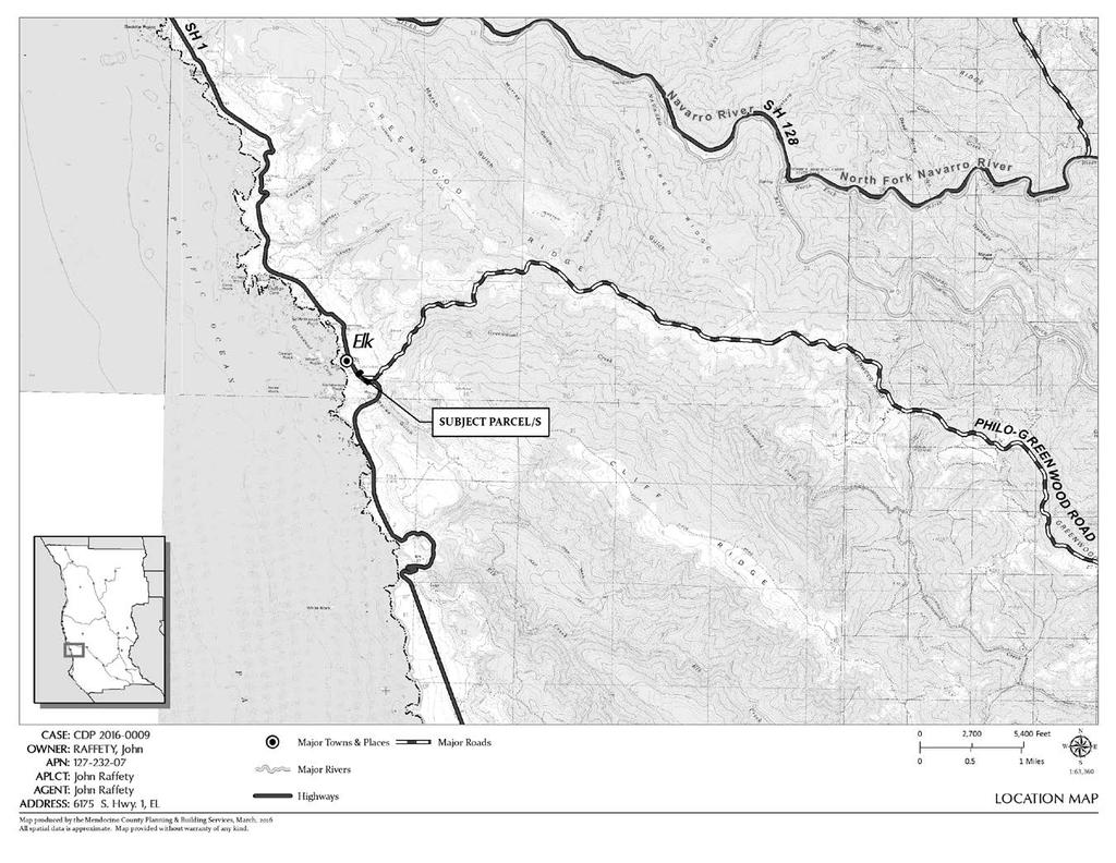
1 COASTAL PERMIT ADMINISTRATOR DECEMBER 14, 2016 STAFF REPORT- CDP_STANDARD CDP_ SUMMARY OWNERS: JOHN ARJAY RAFFETY FIJI WAY UNIT A MARINA DEL REY, CA KERRY HEISE, ADINA MERENLENDER 453 MENDOCINO DRIVE UKIAH, CA APPLICANT: AGENT: JOHN ARJAY RAFFETY FIJI WAY UNIT A MARINA DEL REY, CA KEVIN JOE PO BOX 55 ELK, CA REQUEST: A Coastal Development Permit request to grade 258 cubic yards and to pave a new driveway with access to Highway 1, to install wire fencing and two 5-foot tall by 16-foot wide chain-link gates across the proposed driveway. Excavated material would be deposited off-site within Mendocino County LCP boundaries. DATE DEEMED COMPLETE: MAY 9, 2016 LOCATION: TOTAL ACREAGE: GENERAL PLAN: ZONING: APPEAL JURISDICTION: The four-parcel site is located on the east side of Highway 1 approximately 300 feet north of its intersection with Philo-Greenwood Road at S. Hwy 1, Elk (APN , -08, and -09) and 6191 S. Hwy 1, Elk (APN ). Approximately 0.9-acre across four lots Rural Village (RV:U) Rural Village (RV:40K) Yes. Mapped within the Appeal Jurisdiction and Sensitive Coastal Resource Areas (Highly Scenic and special communities or neighborhoods) SUPERVISORIAL DISTRICT: 5 ENVIRONMENTAL DETERMINATION: RECOMMENDATION: STAFF PLANNER: Mitigated Negative Declaration Approve with conditions JULIANA CHERRY
2 COASTAL PERMIT ADMINISTRATOR STAFF REPORT FOR CDP_ CDP_STANDARD PAGE 2 BACKGROUND PROJECT DESCRIPTION: The proposal is to grade a new driveway on a vacant lot (APN ), install two pairs of gates, fencing and vegetation, and to deposit excavated material off-site within Mendocino County LCP boundaries. Grading, planting, and fencing are proposed across the project area (APNs , -08, -09 and ). The applicant proposes to install wire fencing and gates in locations that generally follow the property boundaries of APN Two biological scoping surveys were prepared and mitigation measures are recommended for areas that will be graded along the right-ofway and front yards. APPLICANT S STATEMENT: Install a driveway into a currently unoccupied (formerly developed) lot at 6175 S Highway 1, Elk. The Caltrans encroachment permit/application # RS-0046 requires excavation/grading along the Caltrans Hwy 1 right-of-way and on 2 parcels owned by the applicant and 1 parcel owned by his neighbors (Heise/Merenlender) in order to provide line-of-sight for safe use of the driveway. The driveway apron will be asphalt and transition to a crushed aggregate drive and parking area further into lot APN and APN Existing height and style of wire fencing will be reinstalled as noted on plans, in addition there will be two 5 tall by 16 wide chain link gates on the driveway. Excavated material removed from the project will be deposited off-site on RD Beacon s property which is east of Hwy 1, but not visible from Hwy 1... RELATED APPLICATIONS: On-Site APN / 6191 South Highway 1 Building permits to re-roof in 1997, 2000, Building permit to install interior propane piping in 1998 Building permit to remove a 760 SF Shed in 2011 Building permit to replace a 800 SF Shed in 2011 Building permit to add under-slab plumbing to shed 2012 Building permit to add electric service to shed in 2012 Building permit to add a lot to shop in 2012 Building permit to repair dry rot and repair deck in 2015 On-Site APN / 6185 South Highway 1 Building Permit for electrical work in 1996 On-Site APN / 6181 South Highway 1 Categorical Exclusion Permit for a test well in 1997 SITE CHARACTERISTICS: The project area includes four contiguous parcels (APNs , -08, - 09 and ). Two of the lots are developed with single-family homes (APNs and ). One parcel provides existing, combined access to Highway 1 for the existing two residences (APN ); this existing driveway apron grade gains five feet over a twenty-foot distance. The sharp rise across the existing apron, land contours adjacent to the highway, and a bend in the road reduce sight-lines from/to Highway 1. This location is about 300-feet north of the highway s intersection with Philo- Greenwood Road. The project area is designated as a Highly Scenic Area, is zoned Rural Village District (which has special protections within Elk), is within 200-feet of two Special Treatment Areas (i.e. State Park lands, scenic highway corridor), has a Corridor Preservation Setback, and is located within the Appeal Jurisdiction of the California Coastal Commission. SURROUNDING LAND USE AND ZONING: The surrounding land uses include mostly residential structures facing the east side of Highway 1. To the west is Greenwood-Elk State Park and to the east is the Elk Community Center, vacant land that has a ten-foot wide easement to Pacific Bell which is, also, used for vehicle access by many RV designated lots fronting the highway.
3 COASTAL PERMIT ADMINISTRATOR STAFF REPORT FOR CDP_ CDP_STANDARD PAGE 3 GENERAL PLAN ZONING LOT SIZES USES NORTH Rural Residential-10 Rural Village 0.25 acre Residential EAST Rural Residential-10 Rural Residential acre Civic SOUTH Open Space Rural Village 0.25 acre Residential WEST Public Facility Rural Village 0.25 acre Open Space PUBLIC SERVICES: ACCESS: STATE ROUTE 1 FIRE DISTRICT: ELK VOLUNTEER FIRE DEPARTMENT WATER DISTRICT: ELK COMMUNITY SERVICES DISTRICT SEWER DISTRICT: NONE SCHOOL DISTRICT: MENDOCINO SCHOOL DISTRICT AGENCY COMMENTS: On May 11, 2016 project referrals were sent to the following responsible or trustee agencies with jurisdiction over the Project. Their required related permits, if any, are listed below. Their submitted recommended conditions of approval are contained in Exhibit A of the attached resolution. A summary of the submitted agency comments are listed below. Any comment that would trigger a project modification or denial are discussed in full as key issues in the following section. REFERRAL AGENCIES RELATED PERMIT COMMENT DATE Planning - Ukiah No comment Department of Transportation No response Environmental Health - Fort No comment Bragg Building Inspection - Fort Bragg No comment Assessor No comment Archaeological Commission No response Sonoma State University Comment US Fish & Wildlife Service No response Tribes No response State Clearinghouse No response Caltrans Encroachment Permit No response RS-0046 CalFire Standard 4290 Comment Department of Parks & No response Recreation Department of Fish & Game No response Coastal Commission Comment KEY ISSUES Coastal Element Chapter 3.5 Special Communities, Visual Resources, and Archaeological Resources has three key policies for consideration: 3.5-2, 3.5-9, and General Plan and Zoning Consistency: The proposal is to grade a new driveway, new access to Highway 1, and install fences and gates. This activity is defined as Other Necessary and Customary Uses associated with a principal permitted use. The principal permitted use, a single-family residence, is located on the adjacent lot under the same ownership. Staff finds the proposed land use consistent with the Rural Village land use designation and zoning code for accessory land uses.
4 COASTAL PERMIT ADMINISTRATOR STAFF REPORT FOR CDP_ CDP_STANDARD PAGE 4 2. Local Coastal Plan, Rural Village with Special Protection: Special Communities/Policy identifies special protection for Rural Village lands in Elk to ensure that new development shall remain within the scope and character of existing development in the town. Staff finds that Rural Village and Highly Scenic lots in Elk have vehicle access gates. As a condition of project approval, existing and proposed fences are required to meet a regulatory 42-inch height limitation for fences and gates within required front yards. The fences would be constructed outside of corridor preservation setbacks. Recommended conditions specifying fence location, height, and material support the intent and purpose of designated Highly Scenic Areas, the special protections extended to the Rural Village District in Elk, and the corridor preservation setback requirements. 3. Caltrans Encroachment Permit RS-0046: The scope of work includes grading on private lands and within the highway right-of-way. Grading will move 258-cubic yards of material. To complete work in the right-of-way an encroachment permit is required. The applicant has applied to Caltrans for an encroachment permit to enter the State Highway right-of-way at post mile on Route 1 in Mendocino County to construct a single-family driveway and associated traffic control as per the application received by the Caltrans District 1 Encroachment Permit Office and as amended by this encroachment permit and all future riders. 1 In addition to the Caltrans Encroachment Permit General Provisions, the preliminary permit has 25 special provisions for the property owners to follow (See Encroachment Permit RS-0046, pages 1 and 2). Staff recommends specific conditions of project approval requiring that an encroachment permit is secured, that deposits of excavated material at on- and off-site locations are permitted, and that invasive plant materials are not distributed and create a nuisance. The property owner would also need to secure a PBS Building Permit for grading. California Coastal Commission staff provided comments on the project and requested two conditions. One would limit the dates of construction and the second would require BMPs. Staff finds that the submitted design, supporting documents (Encroachment Permit; Small Construction Site Storm Water Erosion and Sedimentation Control Plan), and a standard condition that the property owner obtain necessary permits for the proposed work and comply with the standards of Chapter Grading, Erosion, and Runoff. 4. Environmental Protection: Grading within a locally designated scenic resource is excluded from the guidelines for a Categorical Exemption from CEQA 2 ; therefore, PBS prepared an initial study and recommends a mitigated negative declaration regarding measures that could lessen the effect of impacts to aesthetics, land use/planning, potential archaeological resources, and vegetation. The project is specifically conditioned to comply with local regulations for visual resources (highly scenic areas, coastal views, scenic highways, and the special protection of Elk s historic character). Recommended conditions of project approval address transparency of fencing material and the location and height of fences. In accordance with Policy , the Archaeological Commission recommended conditions that would require the property owner to provide Cultural Resources Awareness Training. The project, as conditioned, would not have a significant effect on the environment and a mitigated negative declaration is recommended. 1 Clarification: The property is located in a Rural Village District (not a residential district) and it is an undeveloped lot (no residential development). Some grading will occur on a portion of APN , which is a residentially developed lot with a Rural Village land use designation. 2 See Section 15304(A) which states that minor alterations to land are eligible for an exception from CEQA except that grading shall not be exempt in a waterway, in any wetland, in an officially designated(by federal, state, or local government action) scenic area, or in officially mapped areas of severe geologic hazard such as an Alquist-Priolo Earthquake Fault Zone or within an official Seismic Hazard Zone, as delineated by the State Geologist.
5 COASTAL PERMIT ADMINISTRATOR STAFF REPORT FOR CDP_ CDP_STANDARD PAGE 5 RECOMMENDATION By resolution, adopt a Mitigated Negative Declaration from the California Environmental Quality Act and grant a Coastal Development Standard Permit for the Project, as proposed by the applicant, based on the facts and findings and subject to the conditions of approval. DATE JULIANA CHERRY PLANNER III Appeal Period: 10 Days Appeal Fee: $ ATTACHMENTS: A. Location Map B. Topo Map C. Aerial Map D. Site Plan E. Adjacent Parcels F. Zoning Map G. General Plan Map H. LCP Land Use Map I. LCP Land Capabilities Map J. LCP Habitat and Resources Map K. Fire Hazard Zone Map L. Soils Map M. Coastal Groundwater Map N. Highly Scenic Areas Map O. Appealable Areas Map P. Water District Map Coastal Permit Approval Checklist Mitigated Negative Declaration and Initial Study are available online at: RESOLUTION AND CONDITIONS OF APPROVAL (Exhibit A):
6 ATTACHMENT A

7 ATTACHMENT B

8 ATTACHMENT C
9 ATTACHMENT D
10 ATTACHMENT E
11 ATTACHMENT F
12 ATTACHMENT G

13 ATTACHMENT H

14 ATTACHMENT I

15 ATTACHMENT J

16 ATTACHMENT K

17 ATTACHMENT L

18 ATTACHMENT M

19 ATTACHMENT N

20 ATTACHMENT O
21 ATTACHMENT P
22 COASTAL PERMIT APPROVAL CHECKLIST CDP_ (RAFFETY, HEISE, MERENLENDER) DECEMBER 14, 2016 PROJECT TITLE: CDP_ PROJECT LOCATION: S Highway 1 and 6191 S Highway 1 Elk, California APN: , -08, -09, and LEAD AGENCY NAME, ADDRESS AND CONTACT PERSON: GENERAL PLAN DESIGNATION: ZONING DISTRICT Juliana Cherry Mendocino County Planning and Building Services 120 West Fir Street Fort Bragg, California Mendocino County General Plan Coastal Element Rural Village (RV) Mendocino County Coastal Zoning Code Division II Rural Village (RV) DESCRIPTION OF PROJECT: A Coastal Development Permit request to grade 258 cubic yards and to pave a new driveway on a vacant lot with access to Highway 1, to install two pairs of 5-foot tall by 16-foot wide chain-link gates across the proposed driveway and install wire fencing in locations that generally follow the property boundaries. Grading, planting, and fencing are proposed across three lots, two of which are developed with single-family homes. Excavated material will be deposited off site at an approved location within the Coastal Zone. 1 The proposed driveway location would have sufficient sightlines for highway traffic, where the posted speed limit is 35 miles per hour. SITE DESCRIPTION AND SETTING: The site is located in Elk, adjoins Highway 1 along its easterly boundary, and is 300-feet north of the highway s intersection with Philo-Greenwood Road. The project area, consists of three contiguous lots (which consist of four assessor parcels APNs , -08, -09, and ). 2 The project area is designated as a Highly Scenic Area, is zoned Rural Village District (which has special protections within Elk), is within the 200-foot buffer of two Special Treatment Areas (i.e., state park lands and scenic highway corridor), has a Corridor Preservation Setback, and is located within the Appeal Jurisdiction of the California Coastal Commission. While review of the property title does not describe access easements shared between these three lots, two of the three lots (APN , -08 and ) have combined access to Highway 1. Two developed residential parcels (APN and ) share driveway access across APN The project site is just north of a bend in the highway and is 300-feet north of the intersection of Highway 1 and Philo-Greenwood Road. Under existing conditions, vehicle access is challenged by a sharp rise across the existing shared driveway apron (APN ). 4 The existing, rising slope exacerbates reduced sight-lines for vehicles traveling north towards the Town of Elk. The most northerly of the three lots, APN , is undeveloped and is the site of the proposed new driveway with ingress/egress onto Highway 1. Two biological scoping surveys were prepared and mitigation measures are recommended for areas that will be graded along the right-of-way and front 1 Beacon Property, located at 7531 S Highway 1, has an approved coastal development permit, CDP , to accept soil from off-site locations. This location is less than 1.5 miles south of the project site. 2 The site consists of four tax parcels or three legal lots (APNs and -09 make up one lot). Of the four contiguous parcels, three are owned by one of the applicants. Mr. Arjay Raffety owns parcels APNs , -08, and The applicant states that APN has deeded access across APN Filed supplemental application information dated April 25, Over a twenty-foot distance, land elevations gain five feet in height on APN
23 COASTAL PERMIT APPROVAL CHECKLIST CDP_ Page - 2 yards of the three lots. Development is subject to Highly Scenic Area, special protections, Special Treatment Areas 5, Rural Village District, and Corridor Preservation standards. DETERMINATION: The proposed project, with recommended conditions for project approval, can satisfy all required findings for approval of a Coastal Development Permit, pursuant to Sections and of the Mendocino County Coastal Zoning Code, as individually enumerated in this Coastal Permit Approval Checklist Required Findings for All Coastal Development Permits (A) The granting or modification of any coastal development permit by the approving authority shall be supported by findings which establish the following: (1) The proposed development is in conformity with the certified local coastal program. (2) The proposed development will be provided with adequate utilities, access roads, drainage and other necessary facilities. (3) The proposed development is consistent with the purpose and intent of the zoning district applicable to the property, as well as the provisions of this Division and preserves the integrity of the zoning district. (4) The proposed development will not have any significant adverse impacts on the environment within the meaning of the California Environmental Quality Act. (5) The proposed development will not have any adverse impacts on any known archaeological or paleontological resource. (6) Other public services, including but not limited to, solid waste and public roadway capacity have been considered and are adequate to serve the proposed development. (B) If the proposed development is located between the first public road and the sea or the shoreline of any body of water, the following additional finding must be made: (1) The proposed development is in conformity with the public access and public recreation policies of Chapter 3 of the California Coastal Act and the Coastal Element of the General Plan. Inconsistent Consistent (With Conditions of Approval) Consistent (Without Conditions of Approval) Not Applicable (A)(1) The proposed development is in conformity with the certified local coastal program. Consistent (with conditions of approval) 5 Special Treatment Areas are a 200-foot Scenic Highway Corridor and a 200-foot buffer from state park lands. Special Treatment Areas are defined within the Coastal Act (Section and 30417), Mendocino County Coastal Element Visual Resources, and Mendocino County Code Section Special treatment areas are identified within the coastal zone to ensure that natural and scenic resources are adequately protected (Coastal Act Section 30417(b)). Mendocino County Coastal Element describes Special Treatment Areas as intended to minimize changes in appearance. Staff finds that Special Treatment Areas are established to maintain the character and unique qualities of coastal areas adjacent to the highway and state park lands, especially regarding timber harvesting and forest protection.
24 COASTAL PERMIT APPROVAL CHECKLIST CDP_ Page - 3 The Local Coastal Program (LCP) sets goals and policies for managing resource protection and development activity in the Coastal Zone of Mendocino County, an area that extends from the Humboldt County line to the Gualala River. The LCP addresses topics such as Visual Resource Areas, Special Communities, Corridor Preservation, Off-Street Parking, shoreline access and public trails, hazardous areas, environmentally sensitive habitat areas, and more. The LCP serves as an element of the General Plan and includes the Mendocino County Coastal Zoning Code (MCC), and its policies must be consistent with the goals of the California Coastal Act. Various aspects of the LCP are specifically addressed by separate Required and Supplemental Findings for Coastal Development Permits, including utilities, transportation, zoning, California Environmental Quality Act (CEQA) consistency, archaeological resources, public services, coastal access, and resource protection. The following is a discussion of elements of the LCP not specifically addressed elsewhere in this checklist. General Plan Land Use Rural Village The project, as conditioned, complies with the general plan goals and objectives for Rural Village (RV) designated lands 6 and Navarro River to Mallo Pass Creek Planning Area 7 of the Coastal Element. Section 2.2 of the Coastal Element lists the intent of the Rural Village - Coastal land use designation to preserve and maintain the rural atmosphere and visual quality of... Elk... and to provide a variety of community-oriented neighborhood commercial services... Section 4.10 describes Elk as the Coast s only linear historic town and establishes special protections for highly scenic areas where development shall be subordinate to the character of its setting. The town of Elk is a unique community, so distinctive as to make this portion of the coast worth a journey to many visitors. 8 Combined Access: Shared driveway access is encouraged in areas with significant visual resources and special communities, like Elk. 9 There is existing shared egress/ingress across APN for two adjacent residential parcels (APNs and ). Coastal Element, Chapter 3, Policy states: Direct access to Highway 1 shall not be permitted where it is feasible to connect to an existing or proposed public road or to combine access points for two or more parcels. Retaining the use of the existing access point (from APN ) does support Policy Hazards Mendocino County Coastal Element Chapter 3.4, titled Hazards Management, addresses seismic, geologic and natural forces within the Coastal Zone. Mapping does associate the following with the subject site: moderate fire hazard, and beach deposits and stream alluvium and terraces (Zone 3) intermediate shaking. Seismic Activity: The subject properties are not mapped within an Alquist-Priolo Fault Zone and Seismic Hazard Zone. 10 The proposal is to install landscaping, pavement, and fencing on properties situated along the easterly boundary of Highway 1. Landsliding: Chapter 3.4 describes that poorly constructed cut and fill are sources of landsliding. The project site is not a coastal bluff. Although, one of the mapped hazards incudes soil structure that tends to erode (beach deposits and stream alluvium and terraces) and is subject to intermediate shaking. The project does not include construction of a habitable building. [Land] slides mostly occur along road cuts. 11 The applicant has provided engineered grading plans that have been reviewed by Caltrans, for the purposes of issuing an encroachment permit for work along the public right-of-way. The applicant has submitted an erosion control plan. The proposed scope of work includes prevention of land sliding, 6 Chapter 2, Section 2.2 Description of Land Use Plan Map Designations Rural Village - Coastal, of the Coastal Element, Mendocino County General Plan. Available online 7 Chapter 4, Section 4.10 Navarro River to Mallo Pass Creek Planning Area, of the Coastal Element, Mendocino County General Plan. Page 1. Available online 8 ibid. 9 Policy of Chapter 3 The land use plan: resources and development issues and policies. Coastal Element, Mendocino County General Plan. Page 4. Available online 10 California Department of Conservation. The Alquist-Priolo Fault Zone and Seismic Hazard Zone Maps. Available via 11 Chapter 3 The Land Use Plan: Resources and Development Issues and Policies, Section 3.4 Hazards Management, Coastal Element of Mendocino County General Plan. Page 3. Available via
25 COASTAL PERMIT APPROVAL CHECKLIST CDP_ Page - 4 reducing slopes adjacent to the highway, use of waddles during construction, and landscaping postconstruction. Upon the conclusion of grading adjacent to the highway, sight-lines along the highway corridor will be improved across all properties (APN , -08, -09 and ). Erosion: The proposal does not include seawalls, breakwaters, revetments, groins, harbor channels and other structures altering natural shoreline processes or retaining walls. Grading includes moving 258- cubic-yards of soil and driveway base. Twenty (20) cubic yards of excavated material will be deposited off site. Total slope cuts in the right-of-way include 132-cubic yards of soil and 20-cubic-yards of debris. The new driveway will include 53-cubic-yards cut that would be spread across the vacant lot and 53-cubic yards of imported aggregate. The applicant has submitted a completed Small Construction Site Storm Water Erosion and Sedimentation Control Plan. California Department of Transportation Encroachment Permit No RS-0046 also specifies slope stabilization and sediment control requirements during and post-construction activity. Staff recommends a standard condition of project approval to establish that the property owner obtain necessary permits for the proposed work. Standard condition: That this permit shall be subject to the securing of all necessary permits for the proposed development from County, State and Federal agencies having jurisdiction. Recommended condition: Prior to commencement of grading, the property owner shall demonstrate that excavated material can be deposited in an approved off-site location. On October 10, 2016, a response to PBS request for comments from the California Coastal Commission Staff was received. In their response, the Coastal Analyst discussed the suitability of avoiding construction during the rainy season or dates between October 1 and April 1. The basis of their recommendation is to ensure conformity with Mendocino County LUP Policy (water quality protection policies) and MCC Sections and ; therefore, the request is for inclusion of (1) a condition specifying that construction activities be limited to dates between April 1 and October 1 and (2) a second condition requiring BMP s (such as erosion control devices) be installed prior to October 1. The applicant has demonstrated compliance with MCC Chapter Grading, Erosion, and Runoff by submitting a Small Construction Site Storm Water Erosion and Sedimentation Control Plan and committing to comply with the State of California Department of Transportation Encroachment Permit standards and requirements. Staff has reviewed the Coastal Development Permit application, in part, to determine the extent of project-related impacts due to grading, erosion, and runoff and find that the applicant has demonstrated a project that would comply with grading, erosion, sedimentation, and runoff standards detailed within MCC Chapter A Building Permit is required prior to commencement of grading; therefore, PBS Building Inspectors will conduct site visits in accordance with departmental polices including those related to best management practices (BMPs), grading, erosion, and runoff. Flooding: The subject properties are not located within a mapped flood zone or mapped Tsunami Inundation Area. Fire: The four parcels are located in an area characterized by a moderate fire-hazard-severity rating. 12 The project application was referred to the California Department of Forestry and Fire Protection (CalFire) for input. CalFire reviewed the application and commented that the driveway shall meet the PRC 4290 standards. A standard condition of project approval would establish that the property owner obtain necessary permits for the proposed work. Standard condition: That this permit shall be subject to the securing of all necessary permits for the proposed development from County, State and Federal agencies having jurisdiction. Visual Resources Protection of visual resources is a specific mandate of Section of the Coastal Act, and is subsequently addressed in Chapter 3.5 of General Plan s Coastal Element and implemented by MCC Chapter The project site is located within a mapped Highly Scenic Area (HSA), as depicted on 12 Fire Hazard Severity Zones in SRA [map] :150,000. Fire and Resource Assessment Program, California Department of Forestry and Fire Protection.
26 COASTAL PERMIT APPROVAL CHECKLIST CDP_ Page - 5 the Elk LCP Map Rural Village Districts have special protections to retain the scope and character of existing development within communities, such as Elk. 14 Highly Scenic Area: The project area, three RV designated lots, is situated along the easterly right-of-way of Highway 1. This area is mapped as Highly Scenic, where Everything within view easterly of highway is designated highly scenic. 15,16 The purpose is to insure that permitted development shall be sited and designed to protect views to and along the ocean and scenic coastal areas, to minimize the alteration of natural land forms, to be visually compatible with the character of the surrounding areas, and where feasible, to restore and enhance visual quality in visually degraded areas. 17 Section (C)(13) states that driveways shall be sited such that they cause minimum visual disturbance and shall not directly access Highway 1 where an alternate configuration is feasible. 18 The easterly boundary of the project is contiguous with an existing easement (Pacific Bell), but the property owners have not been granted access to this easement. The applicant has demonstrated that alternate access (existing off-site easement) is not feasible at this time; therefore, the applicant requests direct access to Highway 1. The applicant has been encouraged by staff to consider the visual quality of their proposal, especially to consider existing development characteristics within Elk. Special Protections: Rural Village Districts in towns like Elk are extended special protections, i.e. development criteria as set forth in MCC Section (C). 19 Development scale shall be within the existing scope and character of the area. New development shall be sited such that public coastal views are protected. s to historic structures shall be avoided. Building materials and exterior colors shall be compatible with those of existing structures. One relevant characteristic of existing development on residentially developed land in Elk is the use of vehicle-access gates and the juxtaposition of the driveway to the highway and existing development footprints. There are twenty-six parcels in Elk fronting the east side of the highway and designated Highly Scenic and Rural Village. Sixteen developed residential parcels, facing the east side of Highway 1 in Elk, have direct vehicle access to Highway 1. Similar to the proposed driveway, driveways at these locations tend to be paved with gravel and run perpendicular to the highway for the length of the lot. Off-street parking is often provided behind a house or other structure. Seven of twenty-six Rural Village designated parcels have gates fronting the east side of the highway. Residential lots on the west side of the highway have gates, too. Staff finds that the proposed driveway and vehicle-access gates would not impact the special character of Elk. Special Treatment Areas: Other areas of visual significance include a 200-foot designated scenic corridor along both sides of Highway 1 and a 200-foot buffer adjacent to all state parks. The project site is encompassed within the scenic corridor and located within 200-feet of Greenwood-Elk State Park. This is a location where natural and scenic resources are protected by multiple regulations established to protect coast resources. Mendocino County Coastal Element describes Special Treatment Areas as intended to minimize changes in appearance. 13 County of Mendocino Coastal Zone, Map 20 of 31 Maps. Elk. Certified by the Coastal Commission November 20, Policy Chapter 3 The land use plan: resources and development issues and policies. Coastal Element, Mendocino County General Plan. Page 1. The Town of Mendocino is designated as a special community. Development in the Mendocino Town shall maintain and enhance community character, as defined in the Mendocino Town Plan. Other communities and service centers along the Mendocino Coast, including Westport, Caspar, Little River, Albion, Elk and Manchester shall have special protection to the extent that new development shall remain within the scope and character of existing development by meeting the standards of implementing ordinances. [emphasis added] 15 County of Mendocino Coastal Zone, Map 20 of 31 Maps. Elk. Certified by the Coastal Commission November MCC Section (B)(1)... Development on a parcel located partly within the highly scenic areas delineated on the Land Use Maps shall be located on the portion outside the viewshed if feasible. Section Division II of Title 20, Mendocino County Coastal Zoning Code (MCC) Print and available online via 17 MCC Section Purpose. ibid. 18 MCC Section (C) Development Criteria. ibid. 19 MCC Section Special Communities and Neighborhoods. ibid.
27 COASTAL PERMIT APPROVAL CHECKLIST CDP_ Page (A)(2) The proposed development will be provided with adequate utilities, access roads, drainage and other necessary facilities. Consistent (with conditions of approval) Utilities The Department of Environmental Health has reviewed the proposed project and replied that they have no comments at this time. The proposed work includes altering slopes along the public right-of-way and constructing a highway access point with a driveway on an undeveloped lot. Access Roads Mendocino County Department of Transportation (MDOT) was invited to provide comment on the application. A letter to Planning and Building Services from MDOT dated April 13, 2015 recommends approval of the permit request, as the proposed work does not impact a County road. No response was received from California Department of Transportation (CalTrans), but the applicant has filed a copy of their Encroachment Permit No RS A standard condition of project approval would establish that the property owner obtain necessary permits for the proposed work. Standard condition: That this permit shall be subject to the securing of all necessary permits for the proposed development from County, State and Federal agencies having jurisdiction (A)(3) The proposed development, as conditioned, is consistent with the purpose and intent of the zoning district applicable to the property, as well as the provisions of this Division and preserves the integrity of the zoning district. Consistent (with conditions of approval) Intent: The project area is zoned Rural Village (RV). The intent of the RV zoning district is to preserve and maintain the character of the rural atmosphere and visual quality of existing coastal rural villages; to provide a variety of community-oriented neighborhood commercial services; and to provide and allow for mixed residential and commercial activities. The project area is designated Highly Scenic Area and areas with special protections as set forth in MCC Section (C). Highly Scenic Areas and, special protections under the, RV District standards apply to the entire project area and the scope of proposed work. The intent of these designations is protection of the historic character of Elk and to ensure that new development is compatible with existing land forms and or development. Use: The proposed accessory use is defined as Other Necessary and Customary Uses customarily associated with a principal permitted use. 20 The proposal is to construct a driveway on an existing vacant lot (APN ) where the principal permitted use is associated with residential uses on an adjoining lot (APN ). The new driveway would provide safe access to APN The site design does not preclude future use of the undeveloped parcel (APN ). Yards: The minimum required front and rear yards in the RV zoning district are twenty feet and side yards are six feet. 21 All four parcels are subject to a Corridor Preservation Setback of forty-five-feet typically measured from the centerline of Highway 1. Corridor Preservation Setback distances are in addition to prescribed front yard setbacks. 22 (The existing residence on parcel is setback sixty-feet from the centerline of Highway 1.) The proposed height and location of fencing shall be changed to conform to Mendocino County Codes. Staff recommends two conditions for project approval. Recommended condition: Pursuant with Corridor Preservation Setback requirements, frontyard development standards, and PBS Fence Policies, no fences shall be located within the 45- foot corridor preservation setback. Corridor preservation setbacks shall be measured perpendicular from the centerline of the existing right-of-way of record or, where no recorded 20 MCC Section (O) Other Necessary and Customary Uses. ibid. 21 MCC Section Minimum Front and Rear Yards. ibid. 22 MCC Section Corridor Preservation Setback requirements. ibid.
28 COASTAL PERMIT APPROVAL CHECKLIST CDP_ Page - 7 right-of-way exists, from the center of the physical road. Prior to final approval for any permit, the property owner shall demonstrate to Planning and Building Services that fencing is located beyond the Corridor Preservation Setback boundary. Recommended condition: Fences located within the 20-foot minimum front yard shall have a maximum height of 42-inches. Recommended condition: Prior to final approval for any Building Permit (grading permit), the property owner(s) shall submit a revised site plan and landscape plan completed to the satisfaction of the Coastal Permit Administrator or his designee. Plans shall note fence height, fence location, and landscape material. Height: The maximum permitted building height in the RV zoning district is thirty-five feet above natural grade. The maximum permitted height for front yard fencing is forty-two inches. Staff recommends two conditions of project approval to establish conformance height requirements. Fencing located within a Highly Scenic Area shall be open, similar to the proposed wire fencing. Recommended condition: Fences located east of the front yard area shall not exceed 72-inches in height and shall be constructed from material that is more than 75-percent transparent, such as the wire fencing noted on the site plan. Recommended condition: Existing fencing on the properties, proposed replacement fencing, and new fencing materials shall meet with stated location and height restrictions, and shall be at least 75-percent transparent (or open). Lot Coverage on APN : The area proposed for pavement is generally 12-feet wide, consisting of a black asphalt-concrete apron and crushed aggregate driveway, and is approximately 200-feet in overall length. Approximate lot coverage is 2,400 square feet of lot area or twenty percent of a 12,600- squre-foot lot. The maximum permitted lot coverage in the RV zoning district is fifty percent. 23 Off-street Parking: In any RV District no motor vehicle over three-quarter ton, boat, or recreational vehicle shall be stored or parked in any front yard setback nor any side or rear yard setback facing a street for a continuous period exceeding seventy-two hours. 24 Staff finds that existing zoning codes sufficiently regulate off-street parking; therefore, staff does not recommend adopting conditions further limiting off-street parking on the vacant lot (A)(4) The proposed development will not have any significant adverse impacts on the environment within the meaning of the California Environmental Quality Act. Consistent (with conditions of approval) Grading within a locally designated scenic resource is excluded from the guidelines for a Categorical Exemption from CEQA; 25 therefore, PBS prepared an initial study and recommends a mitigated negative declaration regarding measures that could lessen the effect of impacts to aesthetics, land use/planning, potential archaeological resources, and vegetation. Recommended conditions of project approval include: 23 Pursuant to MCC Section (12), Lot Coverage means the percentage of gross lot area covered by all buildings and structures on a lot, including decks, and porches, whether covered or uncovered, and all other projections except eaves. Pursuant to MCC Section (34) Structures means anything constructed or erected, the use of which requires location on the ground, including, but not limited to, any building, road, pipe, flume, conduit, siphon, aqueduct, telephone line, electrical power transmission and distribution line, antenna and satellite dish. 24 MCC Section (C) General (Off-street Parking). ibid. 25 See Section 15304(A) which states that minor alterations to land are eligible for an exception from CEQA except that grading shall not be exempt in a waterway, in any wetland, in an officially designated(by federal, state, or local government action) scenic area, or in officially mapped areas of severe geologic hazard such as an Alquist-Priolo Earthquake Fault Zone or within an official Seismic Hazard Zone, as delineated by the State Geologist.
29 COASTAL PERMIT APPROVAL CHECKLIST CDP_ Page - 8 Compliance with local regulations for visual resources (highly scenic areas, coastal views, scenic highways, and the special protection of Elk s historic character). Requiring a reduced height of existing and planned fences, increased transparency of fences, limiting the location and height of fences, and prohibiting parking on vacant lands. Requiring the property owner to provide Cultural Resources Awareness Training. The project, as conditioned, would not have a significant effect on the environment and a mitigated negative declaration is recommended (A)(5) The proposed development will not have any adverse impacts on any known archaeological or paleontological resource. Consistent (with conditions of approval) On June 8, 2016, the Archaeological Commission accepted the site survey and findings that the site lacks integrity. The Commission recommends one condition for project approval and requests appropriate training prior to commencing site work, grading, or other ground disturbing activities. Further, Staff recommends consideration of a standard condition that establishes procedures when cultural resources are discovered. Recommended condition: Cultural Resources Awareness Training shall be provided prior to commencing site work, grading, or other ground disturbing activities. Training shall be the obligation of the property owner(s) and shall be provided to any person conducting work on-site. Standard condition: If any archaeological sites or artifacts are discovered during site excavation or construction activities, the applicant shall cease and desist from all further excavation and disturbances within one hundred (100) feet of the discovery, and make notification of the discovery to the Director of the Department of Planning and Building Services. The Director will coordinate further actions for the protection of the archaeological resources in accordance with Section of the Mendocino County Code (A)(6) Other public services, including but not limited to, solid waste and public roadway capacity have been considered and are adequate to serve the proposed development. Consistent (without conditions of approval) Solid Waste: The nearest solid waste transfer station is South Coast Transfer Station, Fish Rock Road, Gualala. This location is 30 miles south of the project site. Recommended conditions include requiring the applicant to demonstrate excavated material can be deposited in an approved off-site location. Recommended condition: Prior to commencement of grading, the property owner shall demonstrate that excavated material can be deposited in an approved off-site location. Roadway Capacity: The subject property is located at 6175 S Highway 1, which is approximately 300-feet north of its intersection with Philo-Greenwood Road. The State Route 1 Corridor Study Update provides traffic volume data for Highway 1. The nearest data breakpoint in the study is located at the intersection of Philo-Greenwood Road and Highway 1. The existing level of service at peak hour conditions at this location is considered Level of Service A. 26 No change in service levels is anticipated. Staff notes that between years , the intersection of Highway 1 and Philo-Greenwood Road had no reported collisions and the posted maximum speed is 35 miles per hour. The project design includes grading that would create 209-feet line-of-site from the proposed driveway s intersection with Highway State Route 1 Corridor Study Update for the County of Mendocino. Rep. Santa Rosa: Whitlock & Weinberger Transportation, Print and available online via
30 COASTAL PERMIT APPROVAL CHECKLIST CDP_ Page (B)(1) If the proposed Development is located between the first public road and the sea or the shoreline of any body of water, the following additional finding must be made: The proposed development is in conformity with the public access and public recreation policies of Chapter 3 of the California Coastal Act and the Coastal Element of the General Plan. Consistent (with conditions of approval) The project site is located east of Highway 1 and is not designated as a potential public access trail location on the Elk LCP Map 20. In Elk, coastal access is provided contiguous with the west side of Highway 1. The project would have no effect on public access to the coast. Within 200-feet of the project site is Greenwood-Elk State Park, with coastal access, headlands and an undeveloped beach. The project area is located within the 200-foot buffer for Greenwood-Elk State Park, a Special Treatment Area (A) Resource Protection Findings Inconsistent (1) Development in Environmentally Sensitive Habitat Areas. No development shall be allowed in an ESHA unless the following findings are made: (a) The resource as identified will not be significantly degraded by the proposed development. (b) There is no feasible less environmentally damaging alternative. (c) All feasible mitigation measures capable of reducing or eliminating project related impacts have been adopted. (2) Finding For Resource Lands Designated AG, RL and FL. No permit shall be granted in these zoning districts until the following finding is made: (a) The proposed use is compatible with the longterm protection of resource lands. Consistent (With Conditions of Approval) Consistent (Without Conditions of Approval) Not Applicable (A)(1), et. seq. No development shall be allowed in an ESHA unless the following findings are made. The Mendocino County LCP includes sections of both the MCC and the Coastal Element of the General Plan addressing Environmentally Sensitive Habitat Areas (ESHA). The MCC states that development having the potential to affect an ESHA shall be subject to a biological survey, prepared by a qualified biologist, to determine the extent of sensitive resources, to document potential negative impacts, and to recommend appropriate mitigation measures. No impact to biological resources would result from the proposed driveway and grading along Highway 1, in Elk. Two separate biological scoping surveys were 27, 28 prepared and neither found impacts to biological resources. Heise and Spade included recommendations to reduce on-site invasive plants, limit redistribution of invasive plants to off-site locations, and to survey for nesting birds and red-legged frogs prior to commencing work. Recommended conditions of project approval include the following: Recommended condition: Replacement of vegetation shall utilize regionally appropriate native plants or non-native plants that are known not to persist or spread in the ecosystem (non- 27 Botanical Survey: Raffety Grading and Encroachment Project. Kerry Heise Botanical Consulting, Ukiah, CA. February 18, Wildlife Scoping Survey Report for 6175, 6181, & 6185 South Highway 1, Elk. Spade Natural Resources Consulting, Fort Bragg, CA. February 10, 2016.
31 COASTAL PERMIT APPROVAL CHECKLIST CDP_ Page - 10 invasive). If straw mulch is applied with re-vegetation, clean straw shall be utilized with weed-free straw being the preferred option. Recommended condition: To prevent further spread of invasive plant material, disposal of invasive plant material shall include either on-site composting or on-site burning of the plant material (after it has been thoroughly dried out on-site) Recommended condition: Within 7-days following grading, areas of exposed bare soil shall be seeded with a mix of regional native grasses and forbs, and covered with jute matting. Seeds from common local native species with similar habitat requirements found within the project area should be considered for planting. Recommended condition: Care shall be taken when graded quantities of soil are moved off-site to limit establishing invasive species, their seeds, and other propagules on off-site locations. Recommended condition: Two weeks prior to commencing work, the area shall be surveyed to avoid any potential for disturbance to nesting birds. If no nests are found, vegetation may be removed. If any birds of prey, including but not limited to osprey, begin to build nests near the project area then the Department of Fish and Game or US Fish and Wildlife Services, as appropriate, shall be consulted. Recommended condition: To avoid impacts to the Northern red-legged frog, construction crews and property owners shall be instructed in the identification of NRLF and shall begin each day with a visual search around all stacked or stored materials, as well as along any silt fences to detect NRLF. If NRLF is detected, construction crews will contact the Department of Fish and Game or a qualified biologist prior to initiating any work.
STAFF REPORT FOR STANDARD COASTAL DEVELOPMENT PERMIT #CDP FEBRUARY 26, 2015 CPA - 1 PO BOX 238 APTOS, CA 94001
 STAFF REPORT FOR STANDARD COASTAL DEVELOPMENT PERMIT #CDP 2014-0030 FEBRUARY 26, 2015 CPA - 1 OWNER/APPLICANT: AGENT: REQUEST: HANS HEIM PO BOX 238 APTOS, CA 94001 JAMES HAY PO BOX 762 MENDOCINO, CA 95460
Coastal Permit Administrator 4/27/2017
 Coastal Permit Administrator 4/27/2017 STAFF REPORT- CDP_STANDARD CDP_2014-0027 SUMMARY OWNER/APPLICANT: AGENT: REQUEST: TAMMY BRAY, TERRY BRAY 5959 HIGHWAY 175 HOPLAND, CA 95449 WYNN COASTAL PLANNING
-MENDOCINO COUNTY PLANNING AND BUILDING SERVICES- DIVISION II OF TITLE 20--COASTAL ZONING CODE
 CHAPTER 20.504 VISUAL RESOURCE AND SPECIAL TREATMENT AREAS Sec. 20.504.005 Applicability. Sec. 20.504.010 Purpose. Sec. 20.504.015 Highly Scenic Areas. Sec. 20.504.020 Special Communities and Neighborhoods.
COASTAL PERMIT ADMINISTRATOR OCTOBER 27, 2016
 COASTAL PERMIT ADMINISTRATOR OCTOBER 27, 2016 STAFF REPORT- CDP_STANDARD CDP_2015-0033 SUMMARY OWNER/ APPLICANT: AGENT: REQUEST: PATRICK ELLIS AND LISA LAUER PO BOX 234 GUALALA, CA 95445 CARL RITTIMAN
COASTAL PERMIT ADMINISTRATOR DECEMBER 16, 2015 STAFF REPORT/COASTAL DEVELOPMENT PERMIT
 COASTAL PERMIT ADMINISTRATOR DECEMBER 16, 2015 STAFF REPORT/COASTAL DEVELOPMENT PERMIT CDP_2013-0012 OWNER/APPLICANT: AGENT: REQUEST: LOCATION: APPEALABLE: PERMIT TYPE: SYDNEY MINTZ & JUSTINE SHAPIRO 336
ADDENDUM TO BIOLOGICAL SCOPING SURVEY REPORT, BOTANICAL SURVEY AND WETLAND DELINEATION
 ADDENDUM TO BIOLOGICAL SCOPING SURVEY REPORT, BOTANICAL SURVEY AND WETLAND DELINEATION FOR AVALON INN (APN 069-241-27 & -04) 1201 & 1211 NORTH MAIN STREET FORT BRAGG, CA MENDOCINO COUNTY prepared for:
STAFF REPORT JULY 26, 2017
 COASTAL PERMIT ADMINISTRATOR STAFF REPORT JULY 26, 2017 SUMMARY OWNER/APPLICANT: AGENT: REQUEST: DALE SPRING AND PATRICIA ARNETT 1121 BOONVILLE RD UKIAH, CA 95482 KELLY GRIMES PO BOX 598 LITTLE RIVER,
TOWNSHIP OF LOGAN SOIL & FILL IMPORTATION AND PLACEMENT APPLICATION SUBMITTAL CHECKLIST
 TOWNSHIP OF LOGAN SOIL & FILL IMPORTATION AND PLACEMENT APPLICATION SUBMITTAL CHECKLIST Applications: 5 copies of application - Applicant will reproduce the copies at his/her costs. The Township Clerk
CLACKAMAS COUNTY ZONING AND DEVELOPMENT ORDINANCE
 704 RIVER AND STREAM CONSERVATION AREA (RSCA) 704.01 PURPOSE Section 704 is adopted to: A. Maintain the integrity of the rivers and streams in the County by minimizing erosion, promoting bank stability,
STAFF REPORT FOR COASTAL DEVELOPMENT CDP# ADMINISTRATIVE PERMIT SEPTEMBER 9, 2014 BOS PRESSLEY ROAD SANTA ROSA, CA 95404
 SEPTEMBER 9, 2014 BOS-1 OWNER/APPLICANT: REQUEST: DAVID DERUITER 4714 PRESSLEY ROAD SANTA ROSA, CA 95404 Coastal Development Permit for a single family residence, barn, guest cottage, driveway and related
Exhibit A. 8:9 Scuffletown Rural Conservation District
 Exhibit A 8:9 Scuffletown Rural Conservation District 8:9.1 Intent and Purpose The Scuffletown Rural Conservation (SRC) District is intended to provide for residential development that supports the development
ARTICLE IV: DEVELOPMENT STANDARDS 404 MASTER PLANNING
 IV 13 404 MASTER PLANNING Master Planning through the Site Analysis (Master Planning Site Analysis) or Planned Development (Master Planning Planned Development) is provided to encourage development which
Procedures IV. V. Rural Road Design Option
 i IV. Procedures A. All applicants required to prepare a Conservation Design Subdivision shall provide the Planning Board with a conceptual conventional subdivision design as well as a proposed layout
STREAM BUFFERS
 88-415 STREAM BUFFERS 88-415-01 PURPOSE In the Kansas City region and throughout the nation, vegetated stream buffers have been clearly shown to protect stream stability and related infrastructure, improve
SENSITIVE LANDS OVERLAY
 SENSITIVE LANDS OVERLAY Chapter 22 Sensitive Lands Overlay 22.1 PURPOSE 22.2 APPLICATION AND ANALYSIS REQUIREMENTS 22.3 SENSITIVE LAND REGULATIONS 22.4 ADMINISTRATIVE PROVISIONS 22.5 DESIGN STANDARDS 22.6
Zoning Ordinance Article 3
 Article 3 Natural Resources Protection Section 301 Natural Resources Protection 301.1. Purpose - The following natural resources protection standards are established to protect the public health, safety
Neo-Traditional Overlay Application
 MAYOR AND CITY COUNCIL OF LAUREL DEPARTMENT OF ECONOMIC AND COMMUNITY DEVELOPMENT 8103 Sandy Spring Road Laurel, Maryland 20707 (301) 725-5300 Internet Address http://www.cityoflaurel.org E-mail: ecd@laurel.md.us
Major Subdivision Sketch Plan Checklist
 This checklist provides specific requirements that are apart of the Sketch process. The entire process is described by the Huntersville Subdivision Review Process which details all the submittal and resubmittal
COUNTY COUNCIL OF PRINCE GEORGE'S COUNTY, MARYLAND SITTING AS THE DISTRICT COUNCIL 2010 Legislative Session. Council Members Dernoga and Olson
 DR- COUNTY COUNCIL OF PRINCE GEORGE'S COUNTY, MARYLAND SITTING AS THE DISTRICT COUNCIL 00 Legislative Session Bill No. CB--00 Chapter No. Proposed and Presented by Introduced by Co-Sponsors The Chairman
Venice Pumping Plant Dual Force Main Project Draft EIR
 City of Los Angeles 5.9 LAND USE PLANS 5.9.1 Environmental Setting Venice Pumping Plant Dual Force Main Project Draft EIR The Project lies within the bounds of Los Angeles County and the City of Los Angeles.
Asbury Chapel Subdivision Sketch Plan
 Asbury Chapel Subdivision Sketch Plan PART 1: PROJECT SUMMARY Applicant: NVR Inc. Project Size: +/- 76.13 acres Parcel Numbers: 02101112,02116101,02116112, 02116113 Current Zoning: Transitional Residential
CITY OF LAGUNA BEACH COMMUNITY DEVELOPMENT DEPARTMENT STAFF REPORT DESIGN REVIEW BOARD IBOARD OF ADJUSTMENT Coast Highway APN
 CITY OF LAGUNA BEACH COMMUNITY DEVELOPMENT DEPARTMENT STAFF REPORT HEARING DATE: October 13,2011 TO: DESIGN REVIEW BOARD IBOARD OF ADJUSTMENT CASE: Variance 7717 Design Review 11-163 Coastal Development
PARK CITY MUNICIPAL CODE TABLE OF CONTENTS TITLE 15 LAND MANAGEMENT CODE - CHAPTER 2.21
 PARK CITY MUNICIPAL CODE TABLE OF CONTENTS TITLE 15 LAND MANAGEMENT CODE - CHAPTER 2.21 TITLE 15 - LAND MANAGEMENT CODE CHAPTER 2.21 - SENSITIVE LAND OVERLAY ZONE (SLO) REGULATIONS 15-2.21-1. PURPOSE...1
ORDINANCE NO WHEREAS, the City of Kalama has many areas of timberland and open areas inside its City limits adjacent to residential areas;
 ORDINANCE NO. 1342 AN ORDINANCE OF THE CITY OF KALAMA, WASHINGTON ADOPTING A NEW KALAMA MUNICIPAL CODE CHAPTER 17.20 ESTATE LOT FLOATING ZONE TO PROVIDE TRANSITIONAL ZONING OPTIONS FOR RESIDENTIAL DEVELOPMENT
ARTICLE 17 SITE PLAN REVIEW
 ARTICLE 17 SITE PLAN REVIEW 17.01 INTENT AND PURPOSE The intent of this section is to provide for consultation and cooperation between the applicant and the township planning commission so that the applicant
Town of Windham. Planning Department 8 School Road Windham, ME voice fax
 Town of Windham Planning Department 8 School Road Windham, ME 04062 voice 207.864-5960 fax 207.892.1916 MEMO DATE: TO: Staff Review Committee FROM: Amanda Lessard, Planner Cc: Ellen Rathbone, St. Germain
PLANNED DEVELOPMENT (MASTER PLAN & UNIT PLAN)
") Central Permit Center 555 Santa Clara Street Vallejo CA 94590 Business License Building Fire Prevention Planning Public Works 707.648.4310 707.648.4374 707.648.4565 707.648.4326 707.651.7151 PLANNED DEVELOPMENT
Central Permit Center 555 Santa Clara Street Vallejo CA 94590 Business License Building Fire Prevention Planning Public Works 707.648.4310 707.648.4374 707.648.4565 707.648.4326 707.651.7151 PLANNED DEVELOPMENT
Project: Developer/Designer: Reviewer: I. Narrative: 1. Project Description: Describes the nature and purpose of the land disturbing activity.
 City of Charlottesville, Virginia Erosion and Sediment Control Plan Review Checklist 610 East Market Street, Charlottesville, VA 22902 Telephone 434-970-3182; Fax 434-970-3359 Project: Developer/Designer:
City of Lafayette Study Session Staff Report Design Review Commission
 City of Lafayette Study Session Staff Report Design Review Commission Meeting Date: April 24, 2017 Staff: Payal Bhagat, Senior Planner Subject: HDP18-15 & HDP31-15 Ramesh Patel & Melcor Development (Owners),
ARTICLE IX SPECIAL PERMIT USES
 ARTICLE IX SPECIAL PERMIT USES All special permit uses cited in Article IX and Attachment A of this Ordinance or any other Section of this Ordinance shall be subject to Site Plan Review. The procedures
WASHINGTON COUNTY OREGON
 WASHINGTON COUNTY OREGON LONG RANGE PLANNING DIVISION North Bethany Subarea Stream Corridors: Existing Regulations In Oregon, there is a distinct difference between the land use rules that apply in rural
CITY OF CYPRESS 5275 Orange Avenue Cypress, California (714) DESIGN REVIEW COMMITTEE PERMIT PROCESS
 DESIGN REVIEW COMMITTEE PERMIT PROCESS") CITY OF CYPRESS 5275 Orange Avenue Cypress, California 90630 (714) 229-6720 DESIGN REVIEW COMMITTEE PERMIT PROCESS 1. Discuss project with Planning staff to determine zoning regulations, any unusual characteristics
CITY OF CYPRESS 5275 Orange Avenue Cypress, California 90630 (714) 229-6720 DESIGN REVIEW COMMITTEE PERMIT PROCESS 1. Discuss project with Planning staff to determine zoning regulations, any unusual characteristics
Memorandum Planning. Thursday, January 8, 2015
 Memorandum Planning Thursday, January 8, 2015 7.A. To: Coastal Advisory Committee From John Ciampa, Associate Planner Subject: Review Draft Local Coastal Program Copies: James Pechous, City Planner Purpose
SITE PLAN REVIEW ITEMS - REFERENCE CHECKLIST
 City of Seminole 9199 113 th Street N. Seminole, FL 33772 Ph: (727) 392-1966 Fx: (727) 319-6583 SITE PLAN REVIEW ITEMS - REFERENCE CHECKLIST Note: This checklist is designed to aid designers in the review
STREAM BUFFER PROTECTION AND MANAGEMENT
 ORDINANCE NO. 753 AN ORDINANCE AMENDING THE CODE OF ORDINANCES OF THE CITY OF PLEASANT HILL, IOWA 1998, BY ESTABLISHIING CHAPTER 104, STREAM BUFFER PROTECTION AND MANAGEMENT Be it enacted by the City of
SECTION 1 CLEARING /GRADING PERMIT APPLICATION:
 PLEASE REFER TO THE CLEARING & GRADING PERMIT CHECKLIST BELOW FOR SUBMITTAL REQUIREMENTS. SECTION 1 CLEARING /GRADING PERMIT APPLICATION: PROJECT ADDRESS (Street, Suite #): Parcel(s) #: Total Site Area
Appendix I. Checklists
 Appendix I Checklists Town of Greenwich Drainage Manual Department of Public Works - Engineering Division Town Hall - 101 Field Point Road, Greenwich, CT 06836-2540 Phone 203-622-7767 - Fax 203-622-7747
3.10 LAND USE SETTING PROJECT SITE EXISTING LAND USE DESIGNATIONS AND ZONING. General Plan Land Use Designations.
 This section of the Draft EIR addresses the existing land uses on and adjacent to the project site and discusses the potential impacts of the proposed project on existing land uses. Key issues addressed
Glenborough at Easton Land Use Master Plan
 Implementation 114 9.0 IMPLEMENTATION 9.1 OVERVIEW This chapter summarizes the administrative procedures necessary to implement the proposed land use plan, infrastructure improvements, development standards,
City of Larkspur. Notice of Mitigated Negative Declaration for the 285
 Notice of Mitigated Negative Declaration for the 285 Magnolia Avenue Mixed-Use Project Date: December 2, 2013 Responsible Agency: Project Title: 285 Magnolia Avenue Mixed-Use Project Project Address: 285
Nick Sigmund, Sr. Zoning Officer
 Nick Sigmund, Sr. Zoning Officer Wisconsin Department of Natural Resources Administrative Code NR 115 under the authority of Wisconsin Statute 59.692, establishes and provides that shoreland zoning regulations
CITY OF MANHATTAN BEACH DEPARTMENT OF COMMUNITY DEVELOPMENT. TO: Parking and Public Improvements Commission
 Clay Curtin, Management Analyst (I the same walls at a maximum of 1 foot tall. Section 7.36.150 of the Municipal Code permits BY: Eric Haaland, Associate Planner right-of-way) between walkways leading
OCEAN BOULEVARD PLANNED DEVELOPMENT DISTRICT (PD-5)
") OCEAN BOULEVARD PLANNED DEVELOPMENT DISTRICT (PD-5) Ordinance History: C-5562, 1982 The intent of the Planned Development Plan is to provide a framework to guide new development in a way that is sensitive
OCEAN BOULEVARD PLANNED DEVELOPMENT DISTRICT (PD-5) Ordinance History: C-5562, 1982 The intent of the Planned Development Plan is to provide a framework to guide new development in a way that is sensitive
Environmental Protection Ordinances (Performance Zoning) Bedminster Township, Bucks County
 Bedminster Township, Bucks County") Environmental Protection Ordinances (Performance Zoning) Bedminster Township, Bucks County ARTICLE VI. PERFORMANCE STANDARDS Section 600 Compliance All uses, activities, subdivisions and/or land developments
Environmental Protection Ordinances (Performance Zoning) Bedminster Township, Bucks County ARTICLE VI. PERFORMANCE STANDARDS Section 600 Compliance All uses, activities, subdivisions and/or land developments
COUNTY OF RIVERSIDE PLANNING DEPARTMENT STAFF REPORT
 Agenda Item No.: 5.4 Area Map: Jurupa Zoning District: Prado-Mira Loma Supervisorial District: Second Project Planner: Christian Hinojosa Planning Commission: February 3, 2010 Conditional Use Permit No.
Deb Grube, Sr. Zoning Officer
 Deb Grube, Sr. Zoning Officer Wisconsin Department of Natural Resources Administrative Code NR 115 under the authority of Wisconsin Statute 59.692, establishes and provides that shoreland zoning regulations
CHAPTER 22 Rural Open Space Community Developments
 CHAPTER 22 Rural Open Space Community Developments Section 22.1 Description and Purpose The intent of this Chapter is to offer property owners an alternative to traditional zoning requirements for rural
SPECIFIC PLAN Requirements
 CITY OF LANCASTER PLANNING DEPARTMENT 44933 Fern Avenue, Lancaster, California 93534 (661) 723-6100 SPECIFIC PLAN Requirements Purpose The purpose of a specific plan is to provide for the logical development
ARTICLE 3 LANDSCAPING AND SCREENING REQUIREMENTS
 ARTICLE 3 CHAPTER 4 LANDSCAPING AND SCREENING REQUIREMENTS SEC 3.401 SEC 3.402 (D) (E) PURPOSE: The purpose of this Chapter is to establish minimum standards for the design, installation, and maintenance
ELIGIBILITY CRITERIA CHECKLIST OPEN SPACE CLASSIFICATION
 THURSTON COUNTY DEVELOPMENT SERVICES OPEN SPACE TAX PROGRAM ELIGIBILITY CRITERIA CHECKLIST OPEN SPACE CLASSIFICATION Use this checklist to help you determine whether your property is eligible for open
CHAPTER 4 - LAND USE CLASSIFICATIONS
 CHAPTER 4 - LAND USE CLASSIFICATIONS Four new land use classification categories are established in the Gualala Town Plan: Gualala Village Mixed Use; Gualala Highway Mixed Use; Gualala Planned Development
City of Fort Lupton Administrative Site Plan Process
 City of Fort Lupton Administrative Site Plan Process Purpose The Site Plan process is meant to promote orderly and sound development standards as they apply to the City. These site development standards
CASE NUMBER: 16SN0701 APPLICANT: Hanky, LLC
 STAFF S ANALYSIS AND RECOMMENDATION Planning Commission (CPC) Public Hearing Date: MAY 17, 2016 CPC Time Remaining: 100 DAYS Applicant s Agent: DANIEL L. CASKIE (804-569-7060) Applicant s Contact: MICHAEL
St. Croix County Shoreland Overlay Zoning Districts. Public Hearing Community Development Committee December 19, 2013
 St. Croix County Shoreland Overlay Zoning Districts Public Hearing Community Development Committee December 19, 2013 Timeline CDC Review October 17 Public Information Meeting October 29 (6:00-8:00 pm)
Erosion & Sediment Control Plan Application Form & Checklist
 Erosion & Sediment Control Plan Application Form & Checklist GENERAL INFORMATION Application Date: Project Address: Tax Map / Parcel Number(s): PROPERTY OWNER / DEVELOPER Firm Name: Contact Person: Title:
SUBMITTAL REQUIREMENTS
 WHEN PROCESS TYPE III IS USED References to Process Type III applications are found in several places in the Milton Municipal Code (MMC), indicating that the development, activity, or use, is permitted
City of Fort Lupton Site Plan Process
 Form WKBK001 City of Fort Lupton Site Plan Process Purpose The Site Plan process is meant to promote orderly and sound development standards as they apply to the City. These site development standards
Article 6 Tree Protection
 Article 6 Tree Protection 8.1 Purpose 8.2 Applicability 8.2.1 General Provisions 8.2.2 Exemptions 8.3 Permitting Procedure 8.4 Planting Procedure 8.5 Performance Guarantee Required for Belated Planting
The Maryland-National Capital Park and Planning Commission Prince George's County Planning Department Development Review Division
 The Maryland-National Capital Park and Planning Commission Prince George's County Planning Department Development Review Division 301-952-3530 Note: Staff reports can be accessed at www.mncppc.org/pgco/planning/plan.htm.
PLANNED UNIT DEVELOPMENT STAFF REPORT Date: June 2, 2016
 # 9 ZON2016-01032 PLANNED UNIT DEVELOPMENT STAFF REPORT Date: June 2, 2016 DEVELOPMENT NAME JJT Properties LLC LOCATION 1147 & 1151 East I-65 Service Road South and 1180 Sledge Drive (Southeast corner
R E S O L U T I O N. Designation: Section 2, Block 17, Lot 20.G-1 ( ) R-2A (1-Family, 2-acre Minimum Lot Size) 46 North Greenwich Road
 R-2A (1-Family, 2-acre Minimum Lot Size) 46 North Greenwich Road") PLANNING BOARD Arthur Adelman, Chair TOWN OF NORTH CASTLE WESTCHESTER COUNTY 17 Bedford Road Armonk, New York 10504-1898 R E S O L U T I O N Telephone: (914) 273-3542 Fax: (914) 273-3554 www.northcastleny.com
PLANNING BOARD Arthur Adelman, Chair TOWN OF NORTH CASTLE WESTCHESTER COUNTY 17 Bedford Road Armonk, New York 10504-1898 R E S O L U T I O N Telephone: (914) 273-3542 Fax: (914) 273-3554 www.northcastleny.com
Town of Excelsior, Sauk County, Wisconsin DRIVEWAY ORDINANCE
 Town of Excelsior, Sauk County, Wisconsin DRIVEWAY ORDINANCE 1.01 PURPOSE The purpose of this ordinance is to regulate the establishment, construction, improvement, modification or reworking of a driveway
DRIVEWAY REGULATIONS
 TOWN OF NEW LONDON PLANNING BOARD DRIVEWAY REGULATIONS INSTRUCTIONS TO APPLICANTS FOR THE CONSTRUCTION OR ALTERATION OF DRIVEWAYS IMPORTANT: READ CAREFULLY BEFORE FILLING OUT ATTACHED APPLICATION Revised
APPENDIX J PERFORMANCE STANDARDS FOR GRAVEL MINE, PIT MINE, OR QUARRY
 APPENDIX J PERFORMANCE STANDARDS FOR GRAVEL MINE, PIT MINE, OR QUARRY A. Purpose: 1. Regulatory Requirement and Use Mitigation: The purpose of this appendix is to provide a regulatory context (standards)
BEFORE THE HEARINGS EXAMINER FOR THURSTON COUNTY
 COUNTY COMMISSIONERS Cathy Wolfe District One Diane Oberquell District Two Robert N. Macleod District Three HEARING EXAMINER BEFORE THE HEARINGS EXAMINER FOR THURSTON COUNTY In the Matter of the Application
Gadsden County Planning Commission Agenda Request
 Date of Meeting: November 16, 2017 To: From: Through: Subject: Gadsden County Planning Commission Agenda Request Honorable Chairperson and Members of the Board Jill A. Jeglie, AICP, Senior Planner Clyde
City of Lafayette Study Session Staff Report Design Review Commission
 ++ City of Lafayette Study Session Staff Report Design Review Commission Meeting Date: January 08, 2018 Staff: Subject: Chris Juram, Planning Technician SS12-17 Miramar Homebuilders, R-20 Zoning: Request
Planning Commission Staff Report February 19, 2009
 Planning Commission Staff Report February 19, 2009 Project: Warda Warehouse File: EG-08-051 Request: Design Review Location: 9260 Bendel Place APNs: 134-0660-004 Planner: Gerald Park Property Owner/Applicant
Chesapeake Bay Critical Area Conservation Plan
 The Maryland-National Capital Park and Planning Commission Prince George s County Planning Department Development Review Division 301-952-3530 Note: Staff reports can be accessed at www.mncppc.org/pgco/planning/plan.htm.
BUFFERS, TREE PROTECTION AND LANDSCAPING. Sec Purpose and Intent.
 ARTICLE 20 BUFFERS, TREE PROTECTION AND LANDSCAPING Sec. 20.1. Purpose and Intent. Trees improve air and water quality, reduce soil erosion, reduce noise and glare, provide habitat for desirable wildlife,
CITY OF ZEELAND PLANNING COMMISSION
 APPLICATION FOR SITE PLAN REVIEW AND SPECIAL LAND USE Date City Official App. Filing Fee Rec'd ($350) NOTE TO APPLICANT: Please submit this application for Site Plan Review along with twenty (20) copies
CONSERVATION ELEMENT GOALS, OBJECTIVES, AND POLICIES
 CONSERVATION ELEMENT GOALS, OBJECTIVES, AND POLICIES Goal 4 To conserve, manage, appropriately use and protect the natural resources of the City ensuring continued resource availability and environmental
ARTICLE V PLANNED UNIT DEVELOPMENT DISTRICT
 ARTICLE V PLANNED UNIT DEVELOPMENT DISTRICT A. Purpose and Objective The Planned Unit Development (PUD) procedure provides a flexible land use and design regulation through the use of performance criteria
PART 1: PROJECT SUMMARY. The application is Attachment A. The site plan is Attachment B.
 Belleterre Subdivision Sketch Plan Town Board 8.7.17 Belleterre Subdivision Sketch Plan PART 1: PROJECT SUMMARY Applicant: Bowman Development Project Size: +/- 20.85 acres Parcel Number: 01115104 and 01115121
GENERAL LANDSCAPE PROVISIONS. The following landscape provisions shall be adhered to by all land uses unless otherwise noted:
 CHAPTER 1.18 Sections: 1.18.005 Purpose. 1.18.010 Landscaping, Buffering, and Fencing Improvements Required. 1.18.015 General Landscape Provisions. 1.18.020 Landscaping Plan. 1.18.025 Single-Family Dwellings
Development Reviews. An overview of the Commission s review process, primarily in Klickitat County. March 13, 2018
 Development Reviews An overview of the Commission s review process, primarily in Klickitat County March 13, 2018 Who should a landowner work with? Oregon Counties Washington Counties Multnomah County Land
Gloucester County PLAN SUBMITTER'S CHECKLIST
 Page 1 of 9 Gloucester County PLAN SUBMITTER'S CHECKLIST FOR EROSION AND SEDIMENT CONTROL PLANS Please fill in all blanks and please reference the plan sheets/pages where the information may be found,
17.18 SENSITIVE AREAS
 17.18 SENSITIVE AREAS 17.18.010 Purpose...1 17.18.020 Definitions...1 17.18.030 Review Process...1 17.18.040 Sensitive Areas Analysis...2 17.18.050 Standards and Development Plan...3 17.18.060 Geotechnical
R E S O L U T I O N. Single-Family Residence/ Church. 2,488 sq. ft. 2,488 sq. ft. Area Parking Required: Church
 R E S O L U T I O N WHEREAS, the Prince George s County Planning Board is charged with the approval of Detailed Site Plans pursuant to Part 3, Division 9 of the Zoning Ordinance of the Prince George s
SECTION 4(f) DE MINIMIS DOCUMENTATION
 DE MINIMIS DOCUMENTATION") SECTION 4(f) DE MINIMIS DOCUMENTATION Illinois Route 60/83 IL 176 to the intersection of IL 60 (Townline Road) Lake County P-91-084-07 Mundelein Park and Recreation District Project Limit SECTION 4(f)
SECTION 4(f) DE MINIMIS DOCUMENTATION Illinois Route 60/83 IL 176 to the intersection of IL 60 (Townline Road) Lake County P-91-084-07 Mundelein Park and Recreation District Project Limit SECTION 4(f)
Request for an Exception to the Napa County Road and Street Standards
 F Request for an Exception to the Napa County Road and Street Standards Shed Creek Winery Use Permit P16-327 and Use Permit Exception to the Conservation Regulations P17-178 Planning Commission Hearing
RECOMMENDATION REPORT
 DEPARTMENT OF CITY PLANNING RECOMMENDATION REPORT City Planning Commission Case No.: CPC-2012-1165-GPA-ZC Date: August 9, 2012 Time: After 8:30 AM Place: City Hall, Room 350 Public Hearing: Required CEQA
TENTATIVE MAP CHECKLIST
 Business License 707.648.4357 www.cityofvallejo.net Central Permit Center 555 Santa Clara Street Vallejo CA 94590 Building 707.648.4374 Planning 707.648.4326 TENTATIVE MAP CHECKLIST Public Works/Engineering
Planning Commission Staff Report June 5, 2008
 Owner/Applicant Taylor Village Sacramento Investments Partners, LP c/o Kim Whitney 1792 Tribute Road #270 Sacramento, CA 95815 Staff Recommendation Planning Commission Staff Report Project: File: Request:
Staff Report CONDITIONAL USE
 Staff Report PLANNING DIVISION COMMUNITY & ECONOMIC DEVELOPMENT To: From: Salt Lake City Planning Commission Daniel Echeverria, (801) 535-7165, daniel.echeverria@slcgov.com Date: May 21, 2015 Re: PLNPCM2015-00139
ARTICLE VI: SITE PLAN REVIEW
 Section 6.01 - Site Plan Review (All Districts) ARTICLE VI: SITE PLAN REVIEW Site plans give the Planning commission an opportunity to review development proposals in a concise and consistent manner. The
SOIL EROSION AND SEDIMENT CONTROL
 SOIL EROSION AND SEDIMENT CONTROL SECTION 1: AUTHORITY, TITLE AND PURPOSE 11. STATUTORY AUTHORIZATION This ordinance is adopted pursuant to the provisions of the Federal Water Pollution Control Act 86
Chapter 1: General Program Information
 Chapter 1: General Program Information 1.1 Introduction The Montgomery County Stormwater Management Resolution (#03-1-5) was adopted by the County Board of Commissioners on January 22, 2003. The purpose
Decision Notice. Proposed Action
 Decision Notice Paving Weld County Road 105 USDA Forest Service Arapaho and Roosevelt National Forest and Pawnee National Grassland Pawnee National Grassland Ranger District Weld County, Colorado November
City of Sun Prairie Wetland Buffer Reduction Request
 City of Sun Prairie Wetland Buffer Reduction Request Westside Development Area January 9, 2017 Prepared by: City of Sun Prairie 300 E. Main Street Sun Prairie, WI 53590 BACKGROUND The City of Sun Prairie
Construction and Landscaping on Public Property
 Construction and Landscaping on Public Property City of Manhattan Beach Community Development Department 1400 Highland Avenue 310-802-5504 www.citymb.info January, 2004 Construction and Landscaping on
City of Lafayette Staff Report
 City of Lafayette Staff Report For: By: Design Review Commission Greg Wolff, Senior Planner Meeting Date: April 27, 2015 Subject: SS03-15 Gundi & Peter Younger (Owners), R-40 Zoning: Request for a Study
Town of Portola Valley General Plan. Nathhorst Triangle Area Plan
 Town of Portola Valley General Plan Amended December 10, 1997 Table of Contents Introduction... 1 Planning Area... 1 Objectives... 2 Principles... 2 Standards... 4 Description... 4 Community Commercial...
6 PORT SYDNEY SETTLEMENT AREA
 Section 6 Port Sydney Page 61 6 PORT SYDNEY SETTLEMENT AREA 6.1 Basis and Principles Village of Port Sydney Waterfront Community Existing Services 6.1.1 Port Sydney is an historic settlement that has developed
THE CITY COUNCIL OF THE CITY OF SAN JUAN BAUTISTA DOES HEREBY ORDAIN AS FOLLOWS:
 ORDINANCE NO. 2016 01 AN ORDINANCE OF THE CITY OF SAN JUAN BAUTISTA AMENDING THE SAN JUAN BAUTISTA MUNICIPAL CODE TO ADD CHAPTER 11-08 HILLSIDE DEVELOPMENT REGULATIONS WHEREAS, the City Council has reviewed
Zoning Ordinance Chapter 10
 CHAPTER 10 - WASHES SECTION 10.0 GENERAL: A. The purpose of this Ordinance is to establish standards for development in or near Major and Minor Washes as defined in Appendix A Glossary of Terms and Definitions
Site Plan Review Residential Accessory Building
 COMMUNITY DEVELOPMENT DEPARTMENT Planning Division P.O. Box 490 333 Broadalbin Street SW Albany, OR 97321 Phone (541) 917-7550 Fax (541) 917-7598 www.cityofalbany.net Site Plan Review Residential Accessory
PG&E WINTERS GAS OPERATIONS AND TECHNICAL TRAINING CENTER
 PG&E WINTERS GAS OPERATIONS AND TECHNICAL TRAINING CENTER CEQA scoping Meeting March 19 th, 2014 Winters City Council Chambers - 6:30 pm AGENDA FOR THE MEETING 6:30 Welcome (John Donlevy) 6:40 Overview
Plan Review Checklist
 Plan Review Checklist FOR EROSION AND SEDIMENT CONTROL PLANS _ Minimum Standards - All applicable Minimum Standards must be addressed. All minimum Standards must be adhered to during the entire project
2.1.8 Cultural Resources Regulatory Setting. Affected Environment, Environmental
 REVISED DRAFT ENVIRONMENTAL IMPACT REPORT/ Affected Environment, Environmental 2.1.8 Cultural Resources This section evaluates the potential for historical and archaeological resources within the proposed