STAFF REPORT JULY 26, 2017
|
|
|
- Bertha Woods
- 5 years ago
- Views:
Transcription

1 COASTAL PERMIT ADMINISTRATOR STAFF REPORT JULY 26, 2017 SUMMARY OWNER/APPLICANT: AGENT: REQUEST: DALE SPRING AND PATRICIA ARNETT 1121 BOONVILLE RD UKIAH, CA KELLY GRIMES PO BOX 598 LITTLE RIVER, CA Coastal Development Standard Permit request to construct a 2,200-square-foot single-family residence and 840-square-foot detached garage on a 10.5-acre site. DATE DEEMED COMPLETE: December 20, 2016 LOCATION: TOTAL ACREAGE: GENERAL PLAN: ZONING: 1.2± miles south of the Town of Mendocino, lying at the southeast intersection of Highway 1 and Gordon Lane at Gordon Lane, Little River (APN: ) acres Mendocino County General Plan, Coastal Element Rural Residential (RR10:R) Division II, Title 20 of Mendocino County Codes Rural Residential (RR:10) SUPERVISORIAL DISTRICT: 5 ENVIRONMENTAL DETERMINATION: APPEALABLE: RECOMMENDATION: STAFF PLANNER: Class 3(a) Categorical Exemption Yes, Highly Scenic Area Approve with conditions. Juliana Cherry BACKGROUND PROJECT DESCRIPTION: A request for an Coastal Development Standard Permit to construct a 2,200 square foot single family residence; 840 square foot detached garage; a 120 square foot pump house; 3,000-gallon water storage tank; 250 gallon propane tank; 1,500 gallon concrete septic tank and leach lines; and decks. Additionally, a 300 foot long gravel driveway, approximately 12 feet wide, and parking area with encroachment onto Gordon Lane would be constructed. The propane tank would be sited to the east, or rear, of the garage. The driveway and parking area surface would be gravel similar in color and hue to existing conditions. The proposed encroachment on to Gordon Lane would be paved per County standards. No vegetation would be removed on areas other than the proposed building sites and driveway. Electrical and telephone service would be extended approximately 250 feet to the site. APPLICANT S STATEMENT: We are proposing the construct a 2200 square foot, three bedroom residence with a detached, 840 square foot, two-car garage. There will also be a 120 square foot pump house built near the existing well and a 3000 gallon storage tank will be located to the northeast of the
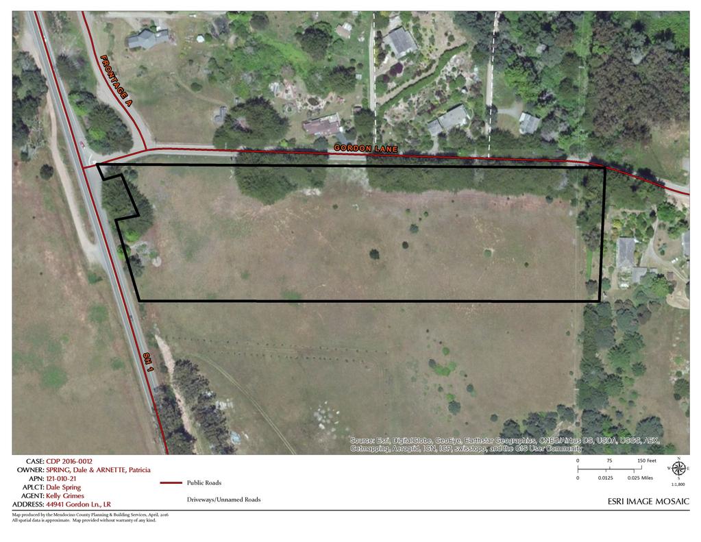
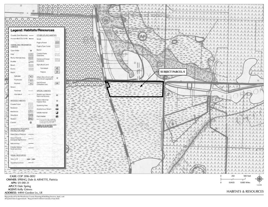
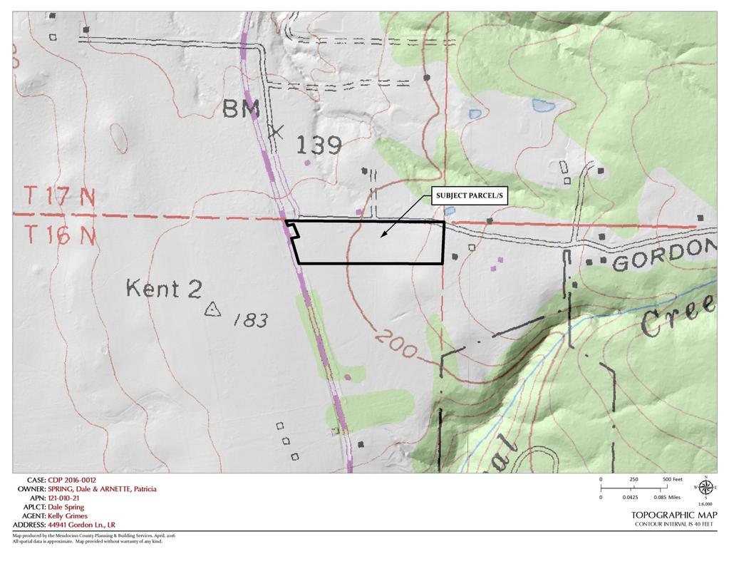
2 COASTAL PERMIT ADMINISTRATOR REPORT FOR COASTAL DEVELOPMENT STANDARD PERMIT PAGE 2 house and garage. The entire project will require almost 3,000 cubic yards of grading which requires no importing or exporting of soil from the project site. Please refer to the Grading Plan submitted (Sheet A7). The roofing will be corrugated metal with copper flashing, gutters and downspouts. The siding will be redwood board and batt siding with a clear oil finish. The exposed framing members will be redwood with a clear oil finish. All windows and skylights will be powder coated aluminum clad windows. Color to be dark bronze. All doors shall be redwood with clear oil finish and dual pane glass as shown on elevations. Metalbestos chimney pipes and Cor-ten metal siding will be utilized in the construction of the outdoor fireplace. All outdoor paving will be natural stone, or tinted concrete. The garage and pump house will both be concrete slabs on grade with all exterior materials to match the main residence. A 250 gallon propane tank will be located to the east (rear) of the garage. The 300 long driveway will be gravel with a concrete apron around the garage and pump house along with a paved encroachment (per County standards) onto Gordon Lane. We are in possession of a valid encroachment permit for the encroachment as shown on the site plan sheet A1. Please refer to sheets A1-A7 for schematic drawings showing all proposed construction. RELATED APPLICATIONS: On-Site: CDMS 9-97 TU_ Neighboring Property: CDP_ CDP_ CDP_ SITE CHARACTERISTICS: The subject property is approximately 10.5 acres and is located directly east of Highway 1, approximately 1.2 miles south of the Town of Mendocino. The lot is a corner lot at the southeast intersection of Highway 1 and Gordon Lane and is situated directly east of Spring Ranch in Little River. (Spring Ranch is public lands with coastal access to the shoreline and bluffs). An existing well is located on the site. The parcel is currently undeveloped and contains mapped prime agricultural land. 1 Additionally, the parcel is currently under a Williamson Act contract until the year 2021; however, there is no evidence of agricultural activity on the site and the contract will not be renewed. The lot s topography includes a gentle rise, gaining about 45 feet in elevation from its midsection to its easterly boundary. The mid-point of the lot is mapped with a 200 foot contour line; therefore, elevations are between 190 feet and 245 feet. The westerly and northerly property boundaries include existing vegetation that obscure views of the land, which is designated as conditionally highly scenic area. 2 Three Environmentally Sensitive Habitat Areas (ESHAs) were observed on or adjacent to the site, including an existing stand of Bishop pine trees located approximately 125 feet south of the site and several occurrences of coastal lotus plants (Hosackia gracilis) on and directly south of the site. A known cultural resource is also located on the site. None of the proposed locations for development would affect identified sensitive coastal resources. The site primarily consists of coastal prairie grassland and contains prime agricultural land on the western half of the site. 3, 4 The project site is located within Seismicity Zone 3. The eastern half of the site is underlain by bedrock, with the western half of the site underlain by beach deposits and stream alluvium and terraces, and is subject to intermediate shaking. 5 The project site is located east of Highway 1 and is not designated as a potential public access trail location. Existing public access to the shore is not currently designated on the LCP Map 17 Mendocino within the vicinity of the site, although shoreline access is proposed northwest of the site. The proposed 1 Lands in Williamson Act Contracts [map]. April :6,000. Mendocino Planning and Building Services. 2 Highly Scenic & Tree Removal Areas [map]. April :12,000. Mendocino Planning and Building Services. 3 Habitats & Resources [map]. April :6,000. Mendocino Planning and Building Services. 4 Capabilities & Hazards [map]. April :6,000. Mendocino Planning and Building Services. 5 Capabilities & Hazards [map]. April :12,000. Mendocino Planning and Building Services.
3 COASTAL PERMIT ADMINISTRATOR REPORT FOR COASTAL DEVELOPMENT STANDARD PERMIT PAGE 3 development would be visible from Highway 1 and other public areas; however, development would be sited and designed to reduce visual impacts by utilizing existing vegetation, structural orientation, landscaping, and would be limited to a single story. The project site is located within a Marginal Water Resources area and a high fire hazard area. 6, 7 Mapping does not associate the following with the subject site: faults, bluffs, landslides, erosion, flood, or tsunami hazard. 8 SURROUNDING LAND USE AND ZONING: Surrounding lots are similarly classified as Rural Residential. Van Damme Beach State Park (Spring Ranch) is located directly west of the highway and project site. The State Park is classified as Open Space. See Table 1. Table 1. Surrounding Land Use and Zoning GENERAL PLAN ZONING LOT SIZES USES NORTH Rural Residential RR5(2) 1-3 acres Single Family Residential EAST Rural Residential RR5(2) 0.95 acre Single Family Residential SOUTH Rural Residential RR acres Single Family Residential WEST Open Space OS 157 acres Open Space PUBLIC SERVICES: Access: GORDON LANE (CR 404A) Fire District: MENDOCINO FIRE DISTRICT Water District: NONE Sewer District: NONE School District: MENDOCINO SCHOOL DISTRICT AGENCY COMMENTS: On October 29, 2016, project referrals were sent to the following responsible or trustee agencies with jurisdiction over the Project. Their required related permits, if any, are listed in Table 2. Their submitted recommended conditions of approval are contained in Exhibit A of the attached resolution. Below is a summary of submitted agency comments (See Table 2). Any comment that would trigger a project modification or denial is discussed in full as key issues in the following section. Table 2. Response to PBS Request for Comments RELATED REFERRAL AGENCIES PERMIT COMMENT DATE Planning - Ukiah Comment Department of Transportation Encroachment Comment Environmental Health - FB No comment Building Services - FB No comment Assessor No response Farm Advisor No response Agriculture Commissioner Wm Act Contract No comment Archaeological Commission Comment US Fish & Wildlife Service No response Tribes Comment State Clearing House No response CalTrans No response CalFire No response 6 Ground Water Resources [map]. April :12,000. Mendocino Planning and Building Services. 7 Fire Hazard Zones & Responsibility Areas [map]. April :12,000. Mendocino Planning and Building Services. 8 Capabilities & Hazards [map]. April :6,000. Mendocino Planning and Building Services.
4 COASTAL PERMIT ADMINISTRATOR REPORT FOR COASTAL DEVELOPMENT STANDARD PERMIT PAGE 4 Table 2. Response to PBS Request for Comments REFERRAL AGENCIES Department of Fish & Wildlife Coastal Commission Department of Parks & Recreation Mendocino School District Mendocino Fire District KEY ISSUES: RELATED PERMIT COMMENT No response No response No response No response No response DATE Coastal Development Permit applications are subject to the findings enumerated in Mendocino County Coastal Zoning Code (MCC) Section and Section Appendix A: Coastal Permit Approval Checklist individually addresses each of the Required Findings for all Coastal Development Permits and any Supplemental Findings applicable to this project. The four key issues listed below are drawn from Appendix A: Coastal Permit Approval Checklist and are included here because either they require special conditions for the findings to be made or they address matters of particular concern by referral agencies. 1. General Plan and Zoning Consistency: General Plan: The subject parcel is classified as Rural Residential (RR) by the Mendocino County General Plan, Coastal Element. The RR plan designation is intended to encourage local small scale food production (farming) in areas which are not well suited for large scale commercial agriculture, defined by present or potential use, location, mini-climate, slope, exposure, etc. The Rural Residential classification is not intended to be a growth area and residences should be located as to create minimal impact on agricultural viability. 9 The principally permitted use designated for this land use classification is residential and associated utilities, light agriculture, home occupation. 10 A single-family residence would be consistent with the intent of the RR classification. Zoning Code: As conditioned, the proposed project would be consistent with Division II of Title 20 of the Mendocino County Zoning Code (MCC) regulations. The zoning district for the site is Rural Residential as described in the Mendocino County Coastal Zoning Regulations. The project has been reviewed for and found consistent with sections related to archeological and cultural resources, transportation and circulation, public access, hazards and grading and erosion control. The intent of the RR District is to encourage and preserve local small scale farming in the Coastal Zone on lands which are not well-suited for large scale commercial agriculture. Residential uses should be located as to create minimal impact on the agricultural viability. 11 Staff finds that the project would be consistent with the development and land use standards for the RR District, ESHA, and Highly Scenic Areas, including MCC Chapters , , and The proposed project would comply with all standards for land use, yards, and building height, as detailed in Appendix A: Coastal Permit Approval Checklist. Archaeological Resources: A known cultural resource is located on the site; however, as proposed, the proposed development area is more than 250 feet beyond the boundaries of the known cultural resource. The Archaeological Commission accepted the archeological survey for the site during its September 14, 2016, meeting. The Archaeological Commission found that the site(s) identified by Jay Flaherty and the November 8, 1991, archaeological report s recommendations shall be strictly adhered to. A standard condition is recommended advising the applicant of the Discovery Clause, which prescribes the 9 Chapter 2.2. Mendocino County, Planning and Building Services, Planning Division. The County of Mendocino General Plan Chapter 2.2. Mendocino County, Planning and Building Services, Planning Division. The County of Mendocino General Plan Mendocino County Coastal Zoning Code, II (1995). Print
5 COASTAL PERMIT ADMINISTRATOR REPORT FOR COASTAL DEVELOPMENT STANDARD PERMIT PAGE 5 procedures subsequent to the discovery of any cultural resources during construction of the project. Based on the action of the Archaeological Commission, staff recommends a condition establishing a 100- foot buffer to protect existing cultural resources. On January 6, 2017, staff received a request, from the Tribal Historic Preservation Office of the Sherwood Valley Band of Pomo, to require by condition that a representative of the Sherwood Valley Band of Pomo monitor all groundbreaking activities and at the property owner s expense. Staff notes that the proposed development would be more than five hundred feet from the identified cultural resource site. With inclusion of the recommended conditions of approval, the staff finds the project would be consistent with Mendocino County policies for protection of paleontological and archaeological resources. Transportation/Circulation: The proposed development would be provided with adequate access roads. Mendocino County Department of Transportation (MDOT) was invited to provide comment on the application. Correspondence to Planning and Building Services from MDOT dated February 9, 2015, requested a condition of project approval requiring the applicant to obtain an encroachment permit for work within the public right-of-way and construct a standard private driveway approach onto Gordon Lane. 2. Environmentally Sensitive Habitat and Other Resource Areas: The project would be consistent with the Mendocino County Code (MCC) Chapter Environmentally Sensitive Habitats and Other Resource Areas. The purpose of this Chapter is to ensure that environmentally sensitive habitat and other designated resource areas are protected for both the wildlife inhabiting them as well as the enjoyment of present and future populations. 12 Environmentally Sensitive Habitat Areas (ESHAs) include: anadromous fish streams, sand dunes, rookeries and marine mammal haul-out areas, wetlands, riparian areas, areas of pygmy vegetation which contain species of rare or endangered plants and habitats of rare and endangered plants and animals. Two reports have been submitted for review: (1) a Biological Scoping Report prepared on March 10, 2016, by Spade Natural Resources Consulting; and (2) a Botanical Addendum prepared on July 7, 2016, by Spade Natural Resources Consulting. No areas of wetland hydrology or special status wildlife species were observed on the site during field surveys. Three Environmentally Sensitive Habitat Areas (ESHAs) were observed on or adjacent to the site, including an existing stand of Bishop pine trees located approximately 125-feet south of the site and several occurrences of coastal lotus plants (Hosackia gracilis) on and directly south of the site. Since these ESHA areas may provide habitat for special-status species, the March 2016 Biological Scoping Report and its July 2016 Botanical Addendum recommend 100-foot buffers from an existing stand of Bishop pines. The reports also recommend another 100-foot buffer from the coastal lotus plants. However, per revised Figure 2 of the Botanical Addendum, a 100-foot buffer from the Bishop pine trees would be located outside of the boundaries of the site. Additionally, Staff recommends inclusion of several additional conditions related to the protection of biological resources, as recommended by the biologist. 3. Visual Resource and Special Treatment Areas: The project site is located within a Conditionally Highly Scenic Area; however, since the project has been designed in accordance with the development criteria for Highly Scenic Area (MCC Section (C)), impacts to visual resources would be minimized. 13 Public access to the shore is designated on the LCP Map 17 Mendocino and located within Van Damme Beach State Park (Spring Ranch). The State Park is situated west of the project, highway, and along the shoreline. There is no evidence of prescriptive access on the project site. The project would have no effect on public access to the coast. 12 Mendocino County Coastal Zoning Code, II (1995). 13 Highly Scenic & Tree Removal Areas [map]. April :12,000. Mendocino County Planning and Building Services.
6 COASTAL PERMIT ADMINISTRATOR REPORT FOR COASTAL DEVELOPMENT STANDARD PERMIT PAGE 6 4. Environmental Protection: The County of Mendocino is the Lead Agency for this project under CEQA. The County of Mendocino finds the project to be categorically exempt from CEQA, under a Class 3(a) Categorical Exemption from CEQA, pursuant to Section 15303, New Construction or Conversion of Small Structures. Since the proposed project involves the construction of a new single-family residence with detached garage and appurtenant structures, the project is exempt from the provisions of CEQA. RECOMMENDATION By resolution, adopt a Class 3(a) Categorical Exclusion from CEQA and grant the Coastal Development Standard Permit for the Project, as proposed by the applicant, based on the facts and findings and subject to the conditions of approval. DATE JULIANA CHERRY Appeal Period: 10 Days Appeal Fee: $1, ATTACHMENTS: A. Adjacent Parcels B. Appealable areas C. Capabilities & Hazards D. ESRI Image Mosaic E. Fire Hazard Zones & Responsibility Areas F. General Plan Classifications G. Ground Water Resources H. Habitats & Resources I. Highly Scenic Areas & Tree Removal Areas J. Lands in Williamson Act Contracts K. LCP Land Use Map 17: Mendocino L. Local Soils M. Location Map N. Topographic Map O. Zoning Display Map RESOLUTION AND EXHIBIT A: CONDITIONS OF APPROVAL APPENDIX A: COASTAL PERMIT APPROVAL CHECKLIST
7 ATTACHMENT A
8 ATTACHMENT B

9 ATTACHMENT C
10 ATTACHMENT D

11 ATTACHMENT E
12 ATTACHMENT F

13 ATTACHMENT G
14 ATTACHMENT H

15 ATTACHMENT I
16 ATTACHMENT J

17 ATTACHMENT K

18 ATTACHMENT L

19 ATTACHMENT M
20 ATTACHMENT N
21 ATTACHMENT O
22 Resolution Number County of Mendocino Ukiah, California July 26, 2017 DALE SPRING AND PATRICIA ARNETT RESOLUTION OF THE COASTAL PERMIT ADMINISTRATOR, COUNTY OF MENDOCINO, STATE OF CALIFORNIA, ADOPTING A CLASS 3(A) CATEGORICAL EXEMPTION FROM CEQA AND GRANTING A COASTAL DEVELOPMENT STANDARD PERMIT TO CONSTRUCT A 2,200-SQUARE-FOOT SINGLE-FAMILY RESIDENCE AND ACCESSORY STRUCTURES. WHEREAS, the applicants, Dale Spring and Patricia Arnett, filed an application requesting an COASTAL DEVELOPMENT STANDARD PERMIT with the Mendocino County Department of Planning and Building Services to construct a 2,200-square-foot single-family residence, 840-square-foot detached garage, and a 120-square-foot pump house, and install a driveway, 3,000-gallon water storage tank, 250- gallon propane tank, 1,500-gallon septic tank and leach lines, and decks at Gordon Lane, Mendocino (APN ); General Plan RR10:R; Zoning RR:10; Supervisorial District 5; (the Project ); and WHEREAS, the application for the Project was deemed complete on December 20, 2016; and WHEREAS, the land located on APN is contracted land, meaning agricultural land restricted by a Williamson Act contract, and such contract will be terminated, by non-renewal, on January 1, 2021; and WHEREAS, a single-family land use is a compatible use with qualifying agricultural uses on any Williamson Act contracted land; and WHEREAS, a single-family land use is a principally permitted land use in the Rural Residential District on which the development site is located and therefore requires a Coastal Development Standard Permit pursuant with Mendocino County Code Section (A)(1); and WHEREAS, the Secretary for Resources has found that certain classes of projects have been determined not to have a significant effect on the environment and are therefore exempt from the requirement for the preparation of environmental documents, and the Project was determined to meet the criteria for a Categorical Exemption from the California Environmental Quality Act (CEQA) under Class 3; and WHEREAS, in accordance with applicable provisions of law, the Coastal Permit Administrator received all relevant evidence presented in writing regarding the Class 3 Categorical Exemption and the Project and administratively approved the Class 3(a) Categorical Exemption and the Project on July 26, 2017; and WHEREAS, the Coastal Permit Administrator has had an opportunity to review this Resolution and finds that it accurately sets forth the intentions of the Coastal Permit Administrator regarding the Class 3(a) Categorical Exemption from CEQA and the Project. NOW, THEREFORE, BE IT RESOLVED, that the Coastal Permit Administrator makes the following findings: 1. Pursuant with MCC Section (A)(1), the proposed development is in conformity with the certified Local Coastal Program, as the proposed single-family residence and appurtenant
23 structures (detached garage, driveway, water storage tank, propane tank, and septic system) would be a principally permitted use in the Rural Residential Land Use Classification and meets the intent of the RR Classification; and 2. Pursuant with MCC Section (A)(2), the proposed development will be provided with adequate utilities, access roads, drainage and other necessary facilities; and 3. Pursuant with MCC Section (A)(3), the proposed development is consistent with the purpose and intent of the Rural Residential District applicable to the property, as well as the provisions of Mendocino County Coastal Zoning Codes, including additional development standards applicable to Conditionally Highly Scenic Areas, and preserves the integrity of the zoning district; and 4. Pursuant with MCC Section (A)(4), the proposed development, if constructed in compliance with the conditions of approval, will not have any significant adverse impacts on the environment, and meets the criteria for a Class 3(a), Section Categorical Exemption within the meaning of the California Environmental Quality Act; and 5. Pursuant with MCC Section (A)(5), the proposed development will not have any adverse impacts on any known archaeological or paleontological resource by constructing the proposed single-family residence and appurtenant structures outside of the boundaries of a known cultural resource; and 6. Pursuant with MCC Section (A)(6), other public services, including but not limited to, solid waste and public roadway capacity have been considered and are adequate to serve the proposed development; and 7. Pursuant with MCC Section (A)(1)(a), the proposed development, as conditioned, will not significantly degrade identified Environmentally Sensitive Habitat Areas, or ESHA, and will avoid impacts of development on ESHA; and 8. Pursuant with MCC Section (B)(1)(a), the project maximizes protection of environmentally sensitive habitat areas by locating all project components outside of the recommended 100-foot buffer areas and no vegetation would be removed on areas other than the building sites and driveways; and 9. Pursuant with MCC Section (B)(1)(b), the project minimizes construction of new roads and other facilities; and 10. Pursuant with MCC Section (B)(1)(c), the project maintains views from beaches, public trails, roads, and views from public viewing areas, or other recreational areas by siting the project along a naturally occurring 25-foot contour line, where the building s roofline would be below the 50-foot contour line associated with a ridgeline. Additionally, the project has been designed to utilize existing vegetation, landscaping, and would be limited to a single-story, and the proposed colors and materials would consist of natural wood and minimal use of reflective surfaces; and 11. Pursuant with MCC Section (B)(1)(d), the project ensures the adequacy of water, waste water disposal and other services, and would be served by an on-site well and septic system and the development s solid waste needs could adequately be served by the Caspar Transfer Station; and
24 12. Pursuant with MCC Section (B)(1)(e), the project ensures the preservation of the rural character of the site and would result in approximately 0.9-percent lot coverage, which is well below the maximum lot coverage of 20-percent allowed in the RR District; and 13. Pursuant with MCC Section (B)(1)(f), the project maximizes preservation of prime agricultural soils by siting all proposed development on the eastern side of the property, outside of the mapped prime agricultural soils on the western half of the site; and 14. Pursuant with MCC Section (B)(1)(g), the project ensures existing land use compatibility by maintaining productivity of on-site and adjacent agricultural lands by siting all proposed development on the eastern side of the property, outside of the mapped prime agricultural soils; and BE IT FURTHER RESOLVED that the Coastal Permit Administrator hereby adopts a Class 3(a) Categorical Exemption from CEQA and the Conditions of Approval. The Coastal Permit Administrator certifies that the Class 3(a) Categorical Exemption from CEQA has been completed, reviewed, and considered, together with the comments received during the public review process, in compliance with CEQA and State and County CEQA Guidelines, and finds that the Class 3(a) Categorical Exemption from CEQA reflects the independent judgment and analysis of the Coastal Permit Administrator. BE IT FURTHER RESOLVED that the Coastal Permit Administrator hereby grants the requested COASTAL DEVELOPMENT STANDARD PERMIT, subject to the conditions of approval in Exhibit A, attached hereto. BE IT FURTHER RESOLVED that the Coastal Permit Administrator designates the Secretary as the custodian of the document and other material that constitutes the record of proceedings upon which the Coastal Permit Administrator decision herein is based. These documents may be found at the office of the County of Mendocino Planning and Building Services, 860 North Bush Street, Ukiah, CA BE IT FURTHER RESOLVED that the Coastal Permit Administrator action shall be final on the 11 th day after the date of the Resolution unless an appeal is taken. I hereby certify that according to the Provisions of Government Code Section delivery of this document has been made. ATTEST: VICTORIA DAVIS BY: IGNACIO GONZALEZ Commission Services Supervisor Interim Director/Coastal Permit Administrator By:
25 EXHIBIT A CONDITIONS OF APPROVAL July 26, 2017 A COASTAL DEVELOPMENT STANDARD PERMIT TO CONSTRUCT A 2,200-SQUARE-FOOT SINGLE- FAMILY RESIDENCE AND ACCESSORY STRUCTURES. APPROVED PROJECT DESCRIPTION: A Coastal Development Standard Permit to construct a 2,200- square-foot single-family residence; 840-square-foot detached garage; a 120-square-foot pump house; a 300-foot-long gravel driveway approximately 12-feet-wide with encroachment onto Gordon Lane; a 3,000- gallon water storage tank; 250-gallon propane tank; 1,500-gallon concrete septic tank and leach lines; and decks. The propane tank will be sited to the east, or rear, of the garage. No vegetation would be removed on areas other than the proposed building sites and driveway. Electrical and telephone service would be extended, underground, approximately 250-feet to the main structure. CONDITIONS OF APPROVAL: 1. This action shall become final on the 11th day following the decision unless an appeal is filed pursuant to Section of the Mendocino County Code. The permit shall become effective after the ten (10) working day appeal period to the Coastal Commission has expired and no appeal has been filed with the Coastal Commission. The permit shall expire and become null and void at the expiration of two years after the effective date except where construction and use of the property in reliance on such permit has been initiated prior to its expiration. 2. To remain valid, progress towards completion of the project must be continuous. The applicant has sole responsibility for renewing this application before the expiration date. The County will not provide a notice prior to the expiration date. 3. The use and occupancy of the premises shall be established and maintained in conformance with the provisions of Division II of Title 20 of the Mendocino County Code. 4. The application, along with supplemental exhibits and related material, shall be considered elements of this permit, and that compliance therewith is mandatory, unless an amendment has been approved by the Coastal Permit Administrator. 5. This permit shall be subject to the securing of all necessary permits for the proposed development from County, State and Federal agencies having jurisdiction. 6. The applicant shall secure all required building permits for the proposed project as required by the Building Inspection Division of the Department of Planning and Building Services. 7. This permit shall be subject to revocation or modification upon a finding of any one or more of the following: a. The permit was obtained or extended by fraud. b. One or more of the conditions upon which the permit was granted have been violated. c. The use for which the permit was granted is conducted so as to be detrimental to the public health, welfare or safety, or to be a nuisance. d. A final judgment of a court of competent jurisdiction has declared one or more conditions to be void or ineffective, or has enjoined or otherwise prohibited the enforcement or operation of one or more such conditions.
26 8. This permit is issued without a legal determination having been made upon the number, size or shape of parcels encompassed within the permit described boundaries. Should, at any time, a legal determination be made that the number, size or shape of parcels within the permit described boundaries are different than that which is legally required by this permit, this permit shall become null and void. 9. If any archaeological sites or artifacts are discovered during site excavation or construction activities, the applicant shall cease and desist from all further excavation and disturbances within one hundred (100) feet of the discovery, and make notification of the discovery to the Director of the Department of Planning and Building Services. The Director will coordinate further actions for the protection of the archaeological resources in accordance with Section of the Mendocino County Code. 10. Ground disturbing activity within 100 feet of any cultural resource is prohibited. 11. At the property owner s expense, a monitor from the Sherwood Valley Band of Pomo shall be onsite during any ground disturbing activity within 200 feet of any cultural resource. 12. Prior to issuance of a building permit in reliance on Coastal Development Permit CDP_ , the applicant shall submit an exterior lighting plan and design details or manufacturer s specifications for all exterior lighting fixtures. Exterior lighting shall be kept to the minimum necessary for safety and security purposes and shall be downcast and shielded, and shall be positioned in a manner that will not shine light or allow light glare to extend beyond the boundaries of the parcel in compliance with Section of the Mendocino County Code. 13. The project shall comply with Section (11) of the Mendocino County Code. The property owner may defer undergrounding overhead transmission lines located a within the 60- foot Pacific Gas and Electric Company (PG&E) easement contiguous with the easterly property line. 14. The property owner shall underground overhead power distribution lines in accordance with Section (C)(12) of the Mendocino County Code, or locate the lines below the fifty-foot contour line. 15. The applicant shall obtain an encroachment permit from the Mendocino County Department of Transportation and construct a standard private driveway approach onto Gordon Lane (CR 404 A), to be surfaced with asphalt concrete, with a minimum width of ten (10) feet and length of fifteen (15) feet from the edge of the County road. 16. A 100-foot buffer from the existing coastal lotus plants shall be observed. Prior to the onset of construction activities, temporary standard exclusionary fencing shall be installed within the site boundaries to protect the identified coastal lotus ESHA areas and shall be erected as close as possible (1-foot to 5-feet) from their identified locations. All construction related activities shall remain outside of this fencing, which shall remain undisturbed during all phases of construction. To insure correct placement of the temporary fencing, a qualified biologist shall direct the installation of the fence. 17. Since the bird-breeding season typically extends from February to August, the clearing of vegetation and the initiation of construction shall occur in the non-breeding season between September and January. If these activities cannot be done in the non-breeding season, a qualified biologist shall perform preconstruction breeding bird surveys within 14 days of the onset of construction or clearing of vegetation. If active breeding bird nests are observed, no ground disturbance activities shall occur within a minimum 100-foot exclusion zone, which shall remain in place around the active nest until all young are no longer dependent upon the nest. A biologist
27 shall monitor the nest site weekly during the breeding season to ensure the buffer is sufficient to protect the nest site from potential disturbances. 18. Since the bat-breeding season typically extends from November 1 to August 31, the clearing of vegetation and the initiation of construction shall occur in the non-breeding season between September and October. If it is necessary to disturb potential bat roost sites during the batbreeding season, a pre-construction survey (including surveying trees, rock outcrops, and buildings subject to removal or demolition for evidence of bat use) shall be conducted. If evidence of bat use is found, a qualified biologist shall conduct acoustic surveys under appropriate conditions using an acoustic detector, to determine whether a site is occupied. If bats are found, a minimum 50-foot buffer shall be implemented around the roost tree. Removal of roost trees shall occur in September and October, or after the bats have left the roost. 19. Landscaping on the parcel shall not include any invasive plants and shall consist of native plants compatible with the adjacent plant communities. 20. Bare soil resulting from tree removal and/or construction activities shall be vegetated and/or covered with wood chips as soon as possible to prevent erosion. 21. The project shall utilize the proposed building materials and color palette, in accordance with MCC Section (C)(3) of the Mendocino County Code, which requires new development be subordinate to the natural setting, minimize reflective surfaces, and utilize building materials, including siding and roof materials, that blend in hue and brightness with their surroundings. a. As proposed, roof material shall be Standing Seam Metal Roofing with a dark bronze color or similar material that is non-reflective and similar in hue and color. Metal materials shall blend in hue and brightness with their surroundings. b. As proposed, exterior building finish shall be Redwood Siding with a natural, oil-finish or similar material sharing hue, color, and texture. c. As proposed, window frame color shall be dark bronze anodized aluminum or similar material, hue, and color. d. To comply with MCC Section (C)(3), reflective metal surfaces shall be patinated or oxidized. Within one year of their installation, metal materials shall blend in hue and brightness with their surroundings; for example, the proposed copper gutters, copper downspouts, and Cor-Ten (or similar weathered steel exterior materials) shall limit reflective surfaces and blend in hue and brightness with their surroundings. 22. To comply with MCC Section (C)(5)(a), development shall be sited near the toe of a slope, below a ridge, and near a wooded area. a. Structures shall fit the hillside sites, rather than altering landform to accommodate buildings designed for level sites (per MCC Section (C)(6)(c)). As shown on Sheet A1 of the proposed site plan, buildings shall be sited between the 25 and 30-foot land contours. b. Roof angles and exterior finishes shall blend with the hillside (per MCC Section (C)(6)(e)). As shown on proposed building elevations, roof ridgelines or apex shall not exceed 18 feet above ground elevation and roof apexes shall be below the 50- foot land contour. c. Development shall be concentrated near existing major vegetation (per MCC Section (C)(6)(d)). As shown on Sheet A1 of the proposed site plan, the driveway shall be adjacent to existing wooded areas, which includes existing trees that shall be maintained and replaced, as needed or identified by Mendocino County.
28 COASTAL PERMIT APPROVAL CHECKLIST JULY 26, 2017 PROJECT TITLE: PROJECT LOCATION: LEAD AGENCY NAME, ADDRESS AND CONTACT PERSON: GENERAL PLAN DESIGNATION: ZONING DISTRICT Gordon Lane Little River, California APN: JULIANA CHERRY Mendocino County Planning and Building Services 120 West Fir Street Fort Bragg, California Mendocino County General Plan Coastal Element Rural Residential (RR10:R) Mendocino County Coastal Zoning Code Division II Rural Residential (RR:10) DESCRIPTION OF PROJECT: Coastal Development Standard Permit request to construct a 2,200- square-foot single-family residence, 840-squarre-foot detached garage, and a 120-square-foot pump house on a acre site. Additionally, a 12-foot-wide gravel driveway and parking area with encroachment onto Gordon Lane, a 3,000-gallon water storage tank, 250-gallon propane tank, 1,500- gallon concrete septic tank, leach lines, and decks would be installed. The propane tank will be sited to the east, or rear, of the garage. Per County standards, the driveway will include a paved encroachment onto Gordon Lane. Electrical and telephone service would be extended approximately 250 feet to the site. No vegetation would be removed on areas other than the proposed building sites and driveway. SITE DESCRIPTION AND SETTING: The subject property is approximately 10.5 acres and is located directly east of Highway 1, approximately 1.2-miles south of the Town of Mendocino. The lot is a corner lot at the southeast intersection of Highway One and Gordon Lane and is situated directly east of Spring Ranch in Little River. (Spring Ranch is public lands with coastal access to the coast line and bluffs). This ten and a half acre lot is undeveloped and contains an existing well. Even though the land is under Williamson Act contract until year 2021, there is no evidence of agricultural activity on the mapped prime agricultural lands and the contract will not be renewed. The lot s topography includes a gentle rise, gaining about 45 feet in elevation from its midsection to its easterly boundary. The mid-point of the lot is mapped with a 200 foot contour line; therefore, elevations are between 190 feet and 245 feet. The westerly and northerly property boundaries include existing vegetation that obscure views of the land, which is designated as Conditionally Highly Scenic Area. The March 10, 2016 Biological Scoping Report and its July 7, 2016 Botanical Addendum recommend 100-foot buffers from an existing stand of Bishop pines and another 100 foot buffer from coastal lotus plants (Spade Natural Resources Consulting). A known cultural resource is also located on the site. None of the proposed locations for development would impact identified sensitive coastal resources. The site primarily consists of coastal prairie grassland and contains prime agricultural land on the western half of the site. 1, 2 The eastern half of the site appears to be underlain by bedrock, with the western half of the site underlain by beach deposits and stream alluvium and terraces, and is subject to intermediate shaking. 3 The project site is located east of Highway 1 and is not designated as a potential public access trail location. Existing public access to the shore is not currently designated on the LCP Map 22 Mendocino within the vicinity of the site, although shoreline access is proposed northwest of the site. The proposed development would be visible from Highway 1 and other public areas; however, development would be sited and designed to reduce visual impacts by utilizing existing vegetation, structural orientation, landscaping, and would be limited to a single story. The project site is located within a Marginal Water 1 Habitats & Resources [map]. April :6,000. Mendocino Planning and Building Services. 2 Capabilities & Hazards [map]. April :6,000. Mendocino Planning and Building Services. 3 Capabilities & Hazards [map]. April :12,000. Mendocino Planning and Building Services.
29 COASTAL PERMIT APPROVAL CHECKLIST Page 2 Resources area 4 and a High Fire Hazard Area 5. Mapping does not associate the following with the subject site: faults, bluffs, landslides, erosion, flood, or tsunami hazard. 6 DETERMINATION: The proposed project would satisfy all required findings for approval of a Coastal Development Permit, pursuant to Sections and of the Mendocino County Coastal Zoning Code, as individually enumerated in this Coastal Permit Approval Checklist Required Findings for All Coastal Development Permits (A) The granting or modification of any coastal development permit by the approving authority shall be supported by findings which establish the following: (1) The proposed development is in conformity with the certified local coastal program. (2) The proposed development will be provided with adequate utilities, access roads, drainage and other necessary facilities. (3) The proposed development is consistent with the purpose and intent of the zoning district applicable to the property, as well as the provisions of this Division and preserves the integrity of the zoning district. (4) The proposed development will not have any significant adverse impacts on the environment within the meaning of the California Environmental Quality Act. (5) The proposed development will not have any adverse impacts on any known archaeological or paleontological resource. (6) Other public services, including but not limited to, solid waste and public roadway capacity have been considered and are adequate to serve the proposed development. (B) If the proposed development is located between the first public road and the sea or the shoreline of any body of water, the following additional finding must be made: (1) The proposed development is in conformity with the public access and public recreation policies of Chapter 3 of the California Coastal Act and the Coastal Element of the General Plan. Inconsist ent Consiste nt (With Condition s of Approval) Consiste nt (Without Condition s of Approval) Not Applicabl e (A)(1) The proposed development is in conformity with the certified local coastal program. Consistent (with conditions of approval) 4 Ground Water Resources [map]. April :12,000. Mendocino Planning and Building Services. 5 Fire Hazard Zones & Responsibility Areas [map]. April :12,000. Mendocino Planning and Building Services. 6 Capabilities & Hazards [map]. April :6,000. Mendocino Planning and Building Services.
30 COASTAL PERMIT APPROVAL CHECKLIST Page 3 The Local Coastal Program (LCP) sets goals and policies for managing resource protection and development activity in the Coastal Zone of Mendocino County, an area that extends from the Humboldt County line to the Gualala River. The LCP addresses topics such as shoreline access and public trails; development in scenic areas; environmentally sensitive habitat areas; cultural resources; and more. The LCP serves as an element of the General Plan and includes the Mendocino County Coastal Zoning Code (MCC), and on November 20, 1985, its policies were certified by the California Coastal Commission as consistent with the goals of the California Coastal Act. Various aspects of the LCP are specifically addressed by separate Required and Supplemental Findings for Coastal Development Permits, including utilities, transportation, zoning, California Environmental Quality Act (CEQA) consistency, archaeological resources, public services, coastal access, and resource protection. The following is a discussion of elements of the LCP not specifically addressed elsewhere in this checklist. General Plan Land Use Rural Residential: The subject parcel is classified as Rural Residential (RR10:R) by the Coastal Element of the Mendocino County General Plan, which is intended to encourage and preserve local small scale farming in the Coastal Zone on lands which are not well-suited for large scale commercial agriculture. Residential uses should be located as to create minimal impact on the agricultural viability. The proposed use, Single-Family Residential, is consistent with the RR classification of the Coastal Element of the Mendocino County General Plan and is a principally permitted land use. Hazards: Mendocino County Coastal Element Chapter 3.4, titled Hazards Management, addresses seismic, geologic and natural forces within the Coastal Zone. Mapping does not associate the following with the subject site: faults, bluffs, landslides, erosion, flood, or tsunami hazard. 7 Seismic Activity: The property neither lies within, nor does it adjoin a mapped Alquist-Priolo Earthquake Fault Zone. 8 The San Andreas Fault is located approximately 4.5 miles west of the project site and is the nearest active fault. The project site is located within Seismicity Zone 3. The eastern half of the site is underlain by bedrock, with the western half of the site underlain by beach deposits and stream alluvium and terraces, and is subject to intermediate shaking. 9 This project does not conflict with any state or local seismic hazard policy or plan. Flooding: There are no mapped 100-year flood zones on the subject parcel, and no conditions are necessary to ensure consistency with flood policy. 10 Fire: The parcel is located in a High Fire Hazard Area. 11 The project application was referred to the California Department of Forestry and Fire Protection (Cal Fire) for input; however no response was received. A State Fire Safe Regulations Application Form was submitted to Cal Fire as part of the project application (Cal Fire File Number ). The Conditions of Approval from Cal Fire, dated May 16, 2017, include conditions regarding address, driveway, defensible space, and maintenance standards. A standard condition requiring the applicant to secure of all necessary permits for the proposed development from County, State and Federal agencies having jurisdiction ensures any fire protection policy or plan would be addressed. Standard Condition: This permit shall be subject to securing of all necessary permits for the proposed development from County, State and Federal agencies having jurisdiction. With the inclusion of the standard condition, staff finds the project would be consistent with Mendocino County policies for fire protection 7 Capabilities & Hazards [map]. April :6,000. Mendocino Planning and Building Services. 8 State of California Special Studies Zones, Department of Conservation, Division of Mines and Geology. 9 Capabilities & Hazards [map]. April :12,000. Mendocino Planning and Building Services. 10 Mendocino County and Incorporated Areas [map] Flood Insurance Rate Map, Panel 1200F, Number 06045C1200F. Federal Emergency Management Agency. 11 Fire Hazard Severity Zones in SRA [map] :150,000. Fire and Resource Assessment Program, California Department of Forestry and Fire Protection.
31 COASTAL PERMIT APPROVAL CHECKLIST Page 4 Visual Resources: Protection of visual resources is a specific mandate of Section of the Coastal Act, and is subsequently addressed in Chapter 3.5 of General Plan s Coastal Element and implemented by Chapter of the MCC. The subject parcel is located within a mapped Conditional Highly Scenic Area (HSA). The purpose of [Chapter Visual Resource and Special Treatment Areas] is to insure that permitted development shall be sited and designed to protect views to and along the ocean and scenic coastal areas, to minimize the alteration of natural land forms, to be visually compatible with the character of surrounding areas and, where feasible, to restore and enhance visual quality in visually degraded areas. PBS Staff reviewed location of the site and determined that the project is visible from public roads and subject to the development criteria of MCC Section (C) et seq, including the requirement to minimize visual impact of development on hillsides. Pursuant to section (C)(1), the proposed development would provide for the protection of coastal views from public areas including highways, roads, coastal trails, vista points, parks, and waters used for recreational purposes by siting the proposed eighteen-foot development along a naturally occurring 25-foot contour line (as shown on the proposed site plan), where the building s roofline would be below the 50-foot contour line associated with a ridgeline (See Table 1). The proposed colors and materials would consist of natural wood and minimal use of reflective surfaces (including window glazing). The Table 1 lists the development criteria MCC Section (C)(2) through (13) and compares aspects of the proposed project with the locally adopted regulations. Table 1: Visual Resource - Highly Scenic Area Development Criteria MCC SECTION (C) EVIDENCE BASED ON PROPOSED PROJECT 1. Protection of coastal views from public areas. The proposed development would be visible from Highway 1 and other public areas; however, development would be sited and designed to reduce visual impacts by utilizing existing vegetation, structural orientation, landscaping, and would be limited to a single story. 2. In highly scenic areas west of Highway 1 as identified on the Coastal Element land use plan maps, new development shall be limited to 18 feet above natural grade unless an increase in height would not affect public views to the ocean or be out of character with surrounding structures. 3. New development shall be subordinate to the natural setting and minimize reflective surfaces. In Highly Scenic Areas, building materials including siding and roof materials shall be selected to blend in hue and brightness with their surroundings. 4. [Any] proposed divisions of land and boundary line adjustments within highly scenic areas shall be analyzed for consistency of potential future development with the regulations of this Chapter, Buildings and building groups that must be sited in highly scenic areas shall be sited: (a) Near the toe of a slope; (b) Below rather than on a ridge; and (c) In or near a wooded area. The project site is located east of Highway 1. The proposed development would be below the maximum height limit. The proposed exterior siding is redwood board and batt with a clear oil finish. A corrugated metal roof. Bronze color, anodized aluminum clad window frames and dark bronze Verlux skylight frames. Land division or boundary line adjustment is not proposed. The development site proposed to follow the 25- foot contour line, which is near the toe of a slope, and is near wooded areas located to the west the primary development site.
STAFF REPORT FOR STANDARD COASTAL DEVELOPMENT PERMIT #CDP FEBRUARY 26, 2015 CPA - 1 PO BOX 238 APTOS, CA 94001
 STAFF REPORT FOR STANDARD COASTAL DEVELOPMENT PERMIT #CDP 2014-0030 FEBRUARY 26, 2015 CPA - 1 OWNER/APPLICANT: AGENT: REQUEST: HANS HEIM PO BOX 238 APTOS, CA 94001 JAMES HAY PO BOX 762 MENDOCINO, CA 95460
Coastal Permit Administrator 4/27/2017
 Coastal Permit Administrator 4/27/2017 STAFF REPORT- CDP_STANDARD CDP_2014-0027 SUMMARY OWNER/APPLICANT: AGENT: REQUEST: TAMMY BRAY, TERRY BRAY 5959 HIGHWAY 175 HOPLAND, CA 95449 WYNN COASTAL PLANNING
COASTAL PERMIT ADMINISTRATOR OCTOBER 27, 2016
 COASTAL PERMIT ADMINISTRATOR OCTOBER 27, 2016 STAFF REPORT- CDP_STANDARD CDP_2015-0033 SUMMARY OWNER/ APPLICANT: AGENT: REQUEST: PATRICK ELLIS AND LISA LAUER PO BOX 234 GUALALA, CA 95445 CARL RITTIMAN
-MENDOCINO COUNTY PLANNING AND BUILDING SERVICES- DIVISION II OF TITLE 20--COASTAL ZONING CODE
 CHAPTER 20.504 VISUAL RESOURCE AND SPECIAL TREATMENT AREAS Sec. 20.504.005 Applicability. Sec. 20.504.010 Purpose. Sec. 20.504.015 Highly Scenic Areas. Sec. 20.504.020 Special Communities and Neighborhoods.
COASTAL PERMIT ADMINISTRATOR DECEMBER 16, 2015 STAFF REPORT/COASTAL DEVELOPMENT PERMIT
 COASTAL PERMIT ADMINISTRATOR DECEMBER 16, 2015 STAFF REPORT/COASTAL DEVELOPMENT PERMIT CDP_2013-0012 OWNER/APPLICANT: AGENT: REQUEST: LOCATION: APPEALABLE: PERMIT TYPE: SYDNEY MINTZ & JUSTINE SHAPIRO 336
COASTAL PERMIT ADMINISTRATOR DECEMBER 14, 2016
 COASTAL PERMIT ADMINISTRATOR DECEMBER 14, 2016 STAFF REPORT- CDP_STANDARD CDP_2016-0009 SUMMARY OWNERS: JOHN ARJAY RAFFETY 13214 FIJI WAY UNIT A MARINA DEL REY, CA 90292 KERRY HEISE, ADINA MERENLENDER
STAFF REPORT FOR COASTAL DEVELOPMENT CDP# ADMINISTRATIVE PERMIT SEPTEMBER 9, 2014 BOS PRESSLEY ROAD SANTA ROSA, CA 95404
 SEPTEMBER 9, 2014 BOS-1 OWNER/APPLICANT: REQUEST: DAVID DERUITER 4714 PRESSLEY ROAD SANTA ROSA, CA 95404 Coastal Development Permit for a single family residence, barn, guest cottage, driveway and related
CITY OF LAGUNA BEACH COMMUNITY DEVELOPMENT DEPARTMENT STAFF REPORT DESIGN REVIEW BOARD IBOARD OF ADJUSTMENT Coast Highway APN
 CITY OF LAGUNA BEACH COMMUNITY DEVELOPMENT DEPARTMENT STAFF REPORT HEARING DATE: October 13,2011 TO: DESIGN REVIEW BOARD IBOARD OF ADJUSTMENT CASE: Variance 7717 Design Review 11-163 Coastal Development
ADDENDUM TO BIOLOGICAL SCOPING SURVEY REPORT, BOTANICAL SURVEY AND WETLAND DELINEATION
 ADDENDUM TO BIOLOGICAL SCOPING SURVEY REPORT, BOTANICAL SURVEY AND WETLAND DELINEATION FOR AVALON INN (APN 069-241-27 & -04) 1201 & 1211 NORTH MAIN STREET FORT BRAGG, CA MENDOCINO COUNTY prepared for:
CITY OF MALIBU PLANNING COMMISSION RESOLUTION NO
 CITY OF MALIBU PLANNING COMMISSION RESOLUTION NO. 16-54 A RESOLUTION OF THE PLANNING COMMISSION OF THE CITY OF MALIBU, CONSIDERING AN ADDENDUM TO THE CERTIFIED CRUMMER SITE SUBDIVISION FINAL EIR AND MAKING
PC RESOLUTION NO
 PC RESOLUTION NO. 14-01-14-02 TENTATIVE TRACT MAP fttm) 17441. REZONE {RZ) 13-003, ARCHITECTURAL CONTROL (AC) 13-003, TREE REMOVAL PERMIT (TRP) 13-052. GRADING PLAN MODIFICATION (GPM) 13-002. CONDITIONAL
ARTICLE IV: DEVELOPMENT STANDARDS 404 MASTER PLANNING
 IV 13 404 MASTER PLANNING Master Planning through the Site Analysis (Master Planning Site Analysis) or Planned Development (Master Planning Planned Development) is provided to encourage development which
THE CITY COUNCIL OF THE CITY OF SAN JUAN BAUTISTA DOES HEREBY ORDAIN AS FOLLOWS:
 ORDINANCE NO. 2016 01 AN ORDINANCE OF THE CITY OF SAN JUAN BAUTISTA AMENDING THE SAN JUAN BAUTISTA MUNICIPAL CODE TO ADD CHAPTER 11-08 HILLSIDE DEVELOPMENT REGULATIONS WHEREAS, the City Council has reviewed
ORDINANCE NO WHEREAS, the City of Kalama has many areas of timberland and open areas inside its City limits adjacent to residential areas;
 ORDINANCE NO. 1342 AN ORDINANCE OF THE CITY OF KALAMA, WASHINGTON ADOPTING A NEW KALAMA MUNICIPAL CODE CHAPTER 17.20 ESTATE LOT FLOATING ZONE TO PROVIDE TRANSITIONAL ZONING OPTIONS FOR RESIDENTIAL DEVELOPMENT
City of Lafayette Study Session Staff Report Design Review Commission
 ++ City of Lafayette Study Session Staff Report Design Review Commission Meeting Date: January 08, 2018 Staff: Subject: Chris Juram, Planning Technician SS12-17 Miramar Homebuilders, R-20 Zoning: Request
PC RESOLUTION NO GRADING PLAN MODIFICATION (GPM)
") PC RESOLUTION NO. 16-07-26- GRADING PLAN MODIFICATION (GPM) 16-006 A RESOLUTION OF THE PLANNING COMMISSION OF THE CITY OF SAN JUAN CAPISTRANO, CALIFORNIA APPROVING GRADING PLAN MODIFICATION (GPM) 16-006,
PC RESOLUTION NO. 16-07-26- GRADING PLAN MODIFICATION (GPM) 16-006 A RESOLUTION OF THE PLANNING COMMISSION OF THE CITY OF SAN JUAN CAPISTRANO, CALIFORNIA APPROVING GRADING PLAN MODIFICATION (GPM) 16-006,
ARTICLE IX SPECIAL PERMIT USES
 ARTICLE IX SPECIAL PERMIT USES All special permit uses cited in Article IX and Attachment A of this Ordinance or any other Section of this Ordinance shall be subject to Site Plan Review. The procedures
RD:VMT:JMD 10/14/2015 RESOLUTION NO.
 RD:VMT:JMD 10/14/2015 RESOLUTION NO. A RESOLUTION OF THE COUNCIL OF THE CITY OF SAN JOSE ADOPTING THE EDENVALE AVENUE PLANNED DEVELOPMENT REZONING PROJECT MITIGATED NEGATIVE DECLARATION, FOR WHICH AN INITIAL
TOWNSHIP OF LOGAN SOIL & FILL IMPORTATION AND PLACEMENT APPLICATION SUBMITTAL CHECKLIST
 TOWNSHIP OF LOGAN SOIL & FILL IMPORTATION AND PLACEMENT APPLICATION SUBMITTAL CHECKLIST Applications: 5 copies of application - Applicant will reproduce the copies at his/her costs. The Township Clerk
City of Lafayette Study Session Staff Report Design Review Commission
 City of Lafayette Study Session Staff Report Design Review Commission Meeting Date: April 24, 2017 Staff: Payal Bhagat, Senior Planner Subject: HDP18-15 & HDP31-15 Ramesh Patel & Melcor Development (Owners),
36.1. PURPOSE APPLICABILITY DESIGN REVIEW GUIDELINES
 CHAPTER 36: DESIGN STANDARDS 36.1. PURPOSE The purpose of this chapter is to ensure that projects are designed and constructed consistent with the Community Design Subelement of the Land Use Element and
Memorandum Planning. Thursday, January 8, 2015
 Memorandum Planning Thursday, January 8, 2015 7.A. To: Coastal Advisory Committee From John Ciampa, Associate Planner Subject: Review Draft Local Coastal Program Copies: James Pechous, City Planner Purpose
COUNTY OF RIVERSIDE PLANNING DEPARTMENT STAFF REPORT
 Agenda Item No.: 5.4 Area Map: Jurupa Zoning District: Prado-Mira Loma Supervisorial District: Second Project Planner: Christian Hinojosa Planning Commission: February 3, 2010 Conditional Use Permit No.
LICENSES FOR UTILITY CROSSINGS OF PUBLIC LANDS AND WATERS ACCORDING TO MINNESOTA RULES CHAPTER [Rules Effective July 1, 2004]
![LICENSES FOR UTILITY CROSSINGS OF PUBLIC LANDS AND WATERS ACCORDING TO MINNESOTA RULES CHAPTER [Rules Effective July 1, 2004]](/thumbs/78/77546780.jpg "LICENSES FOR UTILITY CROSSINGS OF PUBLIC LANDS AND WATERS ACCORDING TO MINNESOTA RULES CHAPTER [Rules Effective July 1, 2004]") LICENSES FOR UTILITY CROSSINGS OF PUBLIC LANDS AND WATERS ACCORDING TO MINNESOTA RULES CHAPTER 6135 [Rules Effective July 1, 2004] Minnesota Department of Natural Resources Division of Lands and Minerals
LICENSES FOR UTILITY CROSSINGS OF PUBLIC LANDS AND WATERS ACCORDING TO MINNESOTA RULES CHAPTER 6135 [Rules Effective July 1, 2004] Minnesota Department of Natural Resources Division of Lands and Minerals
Article 6 Tree Protection
 Article 6 Tree Protection 8.1 Purpose 8.2 Applicability 8.2.1 General Provisions 8.2.2 Exemptions 8.3 Permitting Procedure 8.4 Planting Procedure 8.5 Performance Guarantee Required for Belated Planting
ARTICLE VI: SITE PLAN REVIEW
 Section 6.01 - Site Plan Review (All Districts) ARTICLE VI: SITE PLAN REVIEW Site plans give the Planning commission an opportunity to review development proposals in a concise and consistent manner. The
Project phasing plan (if applicable) 12 copies of site plan
 12 copies of site plan") SITE PLAN REVIEW PERMIT APPLICATION City of Grand Haven, 11 N. Sixth Street, Grand Haven, MI 49417 Phone: (616) 847-3490 Fax: (616) 844-2051 Website: www.grandhaven.org 1. Project Information Address/location
SITE PLAN REVIEW PERMIT APPLICATION City of Grand Haven, 11 N. Sixth Street, Grand Haven, MI 49417 Phone: (616) 847-3490 Fax: (616) 844-2051 Website: www.grandhaven.org 1. Project Information Address/location
RECOMMENDATION REPORT
 DEPARTMENT OF CITY PLANNING RECOMMENDATION REPORT City Planning Commission Case No.: CPC-2012-1165-GPA-ZC Date: August 9, 2012 Time: After 8:30 AM Place: City Hall, Room 350 Public Hearing: Required CEQA
Design Review Commission Report
 City of Beverly Hills Planning Division 455 N. Rexford Drive Beverly Hills, CA 90210 TEL. (310) 285-1141 FAX. (310) 858-5966 Design Review Commission Report Meeting Date: Thursday, March 2, 2017 Subject:
ARTICLE 17 SITE PLAN REVIEW
 ARTICLE 17 SITE PLAN REVIEW 17.01 INTENT AND PURPOSE The intent of this section is to provide for consultation and cooperation between the applicant and the township planning commission so that the applicant
PLANNED DEVELOPMENT (MASTER PLAN & UNIT PLAN)
") Central Permit Center 555 Santa Clara Street Vallejo CA 94590 Business License Building Fire Prevention Planning Public Works 707.648.4310 707.648.4374 707.648.4565 707.648.4326 707.651.7151 PLANNED DEVELOPMENT
Central Permit Center 555 Santa Clara Street Vallejo CA 94590 Business License Building Fire Prevention Planning Public Works 707.648.4310 707.648.4374 707.648.4565 707.648.4326 707.651.7151 PLANNED DEVELOPMENT
SECTION 1 CLEARING /GRADING PERMIT APPLICATION:
 PLEASE REFER TO THE CLEARING & GRADING PERMIT CHECKLIST BELOW FOR SUBMITTAL REQUIREMENTS. SECTION 1 CLEARING /GRADING PERMIT APPLICATION: PROJECT ADDRESS (Street, Suite #): Parcel(s) #: Total Site Area
APPENDIX J PERFORMANCE STANDARDS FOR GRAVEL MINE, PIT MINE, OR QUARRY
 APPENDIX J PERFORMANCE STANDARDS FOR GRAVEL MINE, PIT MINE, OR QUARRY A. Purpose: 1. Regulatory Requirement and Use Mitigation: The purpose of this appendix is to provide a regulatory context (standards)
CITY OF SCANDIA ORDINANCE NO. 174
 CITY OF SCANDIA ORDINANCE NO. 174 AN ORDINANCE AMENDING ORDINANCE NO. 122, THE SCANDIA DEVELOPMENT CODE, CHAPTER 2, SECTION 4.34, REGARDING SOLAR FARMS AND COMMUNITY SOLAR GARDENS The City Council of the
LOS ANGELES AIRPORT/EL SEGUNDO DUNES Specific Plan
 LOS ANGELES AIRPORT/EL SEGUNDO DUNES Specific Plan Ordinance No. 167,940 Effective June 28, 1992 TABLE OF CONTENTS MAP Section 1. Section 2. Section 3. Section 4. Section 5. Section 6. Specific Plan Area
Venice Pumping Plant Dual Force Main Project Draft EIR
 City of Los Angeles 5.9 LAND USE PLANS 5.9.1 Environmental Setting Venice Pumping Plant Dual Force Main Project Draft EIR The Project lies within the bounds of Los Angeles County and the City of Los Angeles.
CHAPTER 10 AESTHETICS
 CHAPTER 10 AESTHETICS CHAPTER 10 AESTHETICS This section identifies and evaluates key visual resources in the project area to determine the degree of visual impact that would be attributable to the project.
DECISION CRITICAL AREAS ALTERATION AND DETERMINATION OF NONSIGNIFICANCE (DNS)
") DECISION CRITICAL AREAS ALTERATION AND DETERMINATION OF NONSIGNIFICANCE (DNS) Development Services Department 17301 133rd Avenue NE Woodinville, WA 98072 425-489-2754 www.ci.woodinville.wa.us Project Name:
DECISION CRITICAL AREAS ALTERATION AND DETERMINATION OF NONSIGNIFICANCE (DNS) Development Services Department 17301 133rd Avenue NE Woodinville, WA 98072 425-489-2754 www.ci.woodinville.wa.us Project Name:
City of Lafayette Staff Report
 City of Lafayette Staff Report For: By: Design Review Commission Greg Wolff, Senior Planner Meeting Date: April 27, 2015 Subject: SS03-15 Gundi & Peter Younger (Owners), R-40 Zoning: Request for a Study
SENSITIVE LANDS OVERLAY
 SENSITIVE LANDS OVERLAY Chapter 22 Sensitive Lands Overlay 22.1 PURPOSE 22.2 APPLICATION AND ANALYSIS REQUIREMENTS 22.3 SENSITIVE LAND REGULATIONS 22.4 ADMINISTRATIVE PROVISIONS 22.5 DESIGN STANDARDS 22.6
City of Larkspur. Notice of Mitigated Negative Declaration for the 285
 Notice of Mitigated Negative Declaration for the 285 Magnolia Avenue Mixed-Use Project Date: December 2, 2013 Responsible Agency: Project Title: 285 Magnolia Avenue Mixed-Use Project Project Address: 285
Planning Commission Staff Report February 19, 2009
 Planning Commission Staff Report February 19, 2009 Project: Warda Warehouse File: EG-08-051 Request: Design Review Location: 9260 Bendel Place APNs: 134-0660-004 Planner: Gerald Park Property Owner/Applicant
SHORE PROTECTION ACT STAFF S FINDINGS & RECOMMENDATIONS
 SHORE PROTECTION ACT STAFF S FINDINGS & RECOMMENDATIONS TO: FROM: Shore Protection Committee: Commissioner Mark Williams, Chairman Mr. Richard Gardner Mr. Henry Morgan Mr. Zach Harris Mr. Bill Hodges Department
R E S O L U T I O N. Single-Family Residence/ Church. 2,488 sq. ft. 2,488 sq. ft. Area Parking Required: Church
 R E S O L U T I O N WHEREAS, the Prince George s County Planning Board is charged with the approval of Detailed Site Plans pursuant to Part 3, Division 9 of the Zoning Ordinance of the Prince George s
PARK CITY MUNICIPAL CODE TABLE OF CONTENTS TITLE 15 LAND MANAGEMENT CODE - CHAPTER 2.21
 PARK CITY MUNICIPAL CODE TABLE OF CONTENTS TITLE 15 LAND MANAGEMENT CODE - CHAPTER 2.21 TITLE 15 - LAND MANAGEMENT CODE CHAPTER 2.21 - SENSITIVE LAND OVERLAY ZONE (SLO) REGULATIONS 15-2.21-1. PURPOSE...1
Town of Florence Florence County, WI DRIVEWAY ORDINANCE
 Town of Florence Florence County, WI 08-10-09 DRIVEWAY ORDINANCE 1.01 PURPOSE The purpose of this Ordinance is to regulate the establishment, construction, improvement, modification or reworking of a driveway
ARTICLE V PLANNED UNIT DEVELOPMENT DISTRICT
 ARTICLE V PLANNED UNIT DEVELOPMENT DISTRICT A. Purpose and Objective The Planned Unit Development (PUD) procedure provides a flexible land use and design regulation through the use of performance criteria
Chesapeake Bay Critical Area Conservation Plan
 The Maryland-National Capital Park and Planning Commission Prince George s County Planning Department Development Review Division 301-952-3530 Note: Staff reports can be accessed at www.mncppc.org/pgco/planning/plan.htm.
14825 Fruitvale Ave.
 REPORT TO THE PLANNING COMMISSION Meeting Date: August 26, 2015 Application: PDR14-0017 Location/APN: 14825 Fruitvale Ave. / 397-18-028 Applicant/Owner: Staff Planner: Sin Yong Michael Fossati 14825 Fruitvale
Note: Staff reports can be accessed at Zone: I-3. Tier:
 The Maryland-National Capital Park and Planning Commission Prince George s County Planning Department Development Review Division 301-952-3530 Note: Staff reports can be accessed at www.mncppc.org/pgco/planning/plan.htm.
Nob Hill Pipeline Improvements Project EIR
 Section 3.1 Aesthetics This section addresses the visual aspects that may affect the views experienced by the public, including the potential to impact the existing character of each area that comprises
COMPLIANCE CHECKLIST HILLSIDE RESIDENTIAL DESIGN GUIDELINES MANUAL
 COMPLIANCE CHECKLIST HILLSIDE RESIDENTIAL DESIGN GUIDELINES MANUAL The following checklist summarizes development guidelines and standards. See the appropriate section for a complete explanation of the
COUNTY COUNCIL OF PRINCE GEORGE'S COUNTY, MARYLAND SITTING AS THE DISTRICT COUNCIL 2010 Legislative Session. Council Members Dernoga and Olson
 DR- COUNTY COUNCIL OF PRINCE GEORGE'S COUNTY, MARYLAND SITTING AS THE DISTRICT COUNCIL 00 Legislative Session Bill No. CB--00 Chapter No. Proposed and Presented by Introduced by Co-Sponsors The Chairman
Notice of Preparation of an Environmental Impact Report and Scoping Meeting for the Canyon Lane Roadway Improvements Development Project
 of an Environmental Impact Report and Scoping Meeting for the As the Lead Agency, the County of San Mateo (County) will prepare an Environmental Impact Report (EIR) for the (project), and would like your
COUNTY OF EL DORADO DEVELOPMENT SERVICES PLANNING COMMISSION STAFF REPORT SPECIAL USE PERMIT
 COUNTY OF EL DORADO DEVELOPMENT SERVICES PLANNING COMMISSION STAFF REPORT Agenda of: November 14, 2013 Item No.: 8.c Staff: Aaron Mount SPECIAL USE PERMIT FILE NUMBER: APPLICANT: REQUEST: LOCATION: Sandra
R E S O L U T I O N. Designation: Section 2, Block 17, Lot 20.G-1 ( ) R-2A (1-Family, 2-acre Minimum Lot Size) 46 North Greenwich Road
 R-2A (1-Family, 2-acre Minimum Lot Size) 46 North Greenwich Road") PLANNING BOARD Arthur Adelman, Chair TOWN OF NORTH CASTLE WESTCHESTER COUNTY 17 Bedford Road Armonk, New York 10504-1898 R E S O L U T I O N Telephone: (914) 273-3542 Fax: (914) 273-3554 www.northcastleny.com
PLANNING BOARD Arthur Adelman, Chair TOWN OF NORTH CASTLE WESTCHESTER COUNTY 17 Bedford Road Armonk, New York 10504-1898 R E S O L U T I O N Telephone: (914) 273-3542 Fax: (914) 273-3554 www.northcastleny.com
CHAPTER 4 - LAND USE CLASSIFICATIONS
 CHAPTER 4 - LAND USE CLASSIFICATIONS Four new land use classification categories are established in the Gualala Town Plan: Gualala Village Mixed Use; Gualala Highway Mixed Use; Gualala Planned Development
PLANNING COMMISSION AGENDA REPORT SEPTEMBER 1, 2016
 PLANNING COMMISSION AGENDA REPORT SEPTEMBER 1, 2016 TO: Members of the Planning Commission FROM: Michael Klein, Planner FILE NO.: 150000780 PROPOSAL: APPLICANT: RECOMMENDATION: A request for a Site Plan
MARIN COUNTY COMMUNITY DEVELOPMENT AGENCY
 MARIN COUNTY COMMUNITY DEVELOPMENT AGENCY ALEX HINDS, DIRECTOR STAFF REPORT TO THE PLANNING COMMISSION Dwaileebe Coastal Permit and Design Review Clearance Item No: 5 Application No: CP 07-10 & DC 07-26
PLANNING COMMISSION AGENDA REPORT APRIL 7, 2016
 PLANNING COMMISSION AGENDA REPORT APRIL 7, 2016 TO: FROM: Members of the Planning Commission Talyn Mirzakhanian, Senior Planner FILE NO.: 160001710 PROPOSAL: APPLICANT: RECOMMENDATION: A request for a
SHORE PROTECTION ACT STAFF S FINDINGS & RECOMMENDATIONS
 SHORE PROTECTION ACT STAFF S FINDINGS & RECOMMENDATIONS TO: FROM: APPLICANT: AGENT: Shore Protection Committee: Commissioner Mark Williams, Chairman Mr. Richard Gardner Mr. Henry Morgan Mr. Zach Harris
COUNTY OF SANTA CRUZ MEMORANDUM. To: Don Bussey, Zoning Administrator From: Lawrence Kasparowitz, Project Planner
 1 - COUNTY OF SANTA CRUZ I MEMORANDUM Date: June 21,2006 To: Don Bussey, Zoning Administrator From: Lawrence Kasparowitz, Project Planner Re: 02-0432 Agenda Date: July 21, 2006 Agenda Item #: 0.1 Time:
CITY OF MORRO BAY PUBLIC SERVICES DEPARTMENT 955 SHASTA AVENUE. MORRO BAY, CA
 CITY OF MORRO BAY PUBLIC SERVICES DEPARTMENT 955 SHASTA AVENUE. MORRO BAY, CA 93442 805-772-6261 When is a Permit Required? Implementation Measures For Major Vegetation Removal, Replacement and Protection
3.1 Aesthetics, Light, and Glare
 3.1 3.1.1 Introduction This section describes the existing aesthetics, light, and glare setting and potential effects from project implementation on visual resources and the site and its surroundings.
Example Codes. City of Brentwood, Tennessee Brentwood Hillside Protection Overlay District Summary
 Example Codes City of Brentwood, Tennessee Brentwood Hillside Protection Overlay District Summary The City of Brentwood in July 2007 adopted a Hillside Protection (HP) Overlay District to address the problems
CLACKAMAS COUNTY ZONING AND DEVELOPMENT ORDINANCE
 704 RIVER AND STREAM CONSERVATION AREA (RSCA) 704.01 PURPOSE Section 704 is adopted to: A. Maintain the integrity of the rivers and streams in the County by minimizing erosion, promoting bank stability,
Appendix G Response to Comments
 Appendix G Response to Comments This appendix contains the comments received during the public circulation and comment period (May 27, 2008 to July 11, 2008). The comments have been numbered (Comment Set
NOTICE OF PREPARATION
 Date: June 30, 2017 CITY OF CITRUS HEIGHTS COMMUNITY & ECONOMIC DEVELOPMENT DEPARTMENT, PLANNING DIVISION 6360 Fountain Square Drive, Citrus Heights, CA 95621 (916) 727-4740 NOTICE OF PREPARATION To: Subject:
NOTICE OF PREPARATION
 NOTICE OF PREPARATION DATE: January 6, 2016 TO: LEAD AGENCY: Responsible Agencies, Organizations, and Interested Parties Contact: Tyler Barrington, Principal Planner Planning Department Community Development
CHAPTER 22 Rural Open Space Community Developments
 CHAPTER 22 Rural Open Space Community Developments Section 22.1 Description and Purpose The intent of this Chapter is to offer property owners an alternative to traditional zoning requirements for rural
CONSERVATION ELEMENT GOALS, OBJECTIVES, AND POLICIES
 CONSERVATION ELEMENT GOALS, OBJECTIVES, AND POLICIES Goal 4 To conserve, manage, appropriately use and protect the natural resources of the City ensuring continued resource availability and environmental
DESIGN REVIEW COMMITTEE AGENDA ITEM
 DESIGN REVIEW COMMITTEE AGENDA ITEM AGENDA DATE: DECEMBER 16, 2015 TO: THRU: FROM: SUBJECT: Chair McCormick and Members of the Design Review Committee Leslie Aranda Roseberry, Planning Manager Kelly Christensen
Glenborough at Easton Land Use Master Plan
 Implementation 114 9.0 IMPLEMENTATION 9.1 OVERVIEW This chapter summarizes the administrative procedures necessary to implement the proposed land use plan, infrastructure improvements, development standards,
CITY OF ALAMEDA PLANNING BOARD Draft RESOLUTION
 CITY OF ALAMEDA PLANNING BOARD Draft RESOLUTION A RESOLUTION OF THE PLANNING BOARD OF THE CITY OF ALAMEDA APPROVING DESIGN REVIEW AND DEVELOPMENT PLAN AMENDMENT APPLICATION PLN13-0157 TO CONSTRUCT ELEVEN
7 May 9, 2012 Public Hearing APPLICANT AND PROPERTY OWNER: COASTAL ENTERPRISES, LLC
 7 May 9, 2012 Public Hearing APPLICANT AND PROPERTY OWNER: COASTAL ENTERPRISES, LLC REQUEST: Variance to Section 5B of the Site Plan Ordinance (Floodplain Regulations) ADDRESS / DESCRIPTION: 601 Sandbridge
City of Placerville Planning Commission AGENDA REPORT ITEM 7
 Placerville, a Unique Historical Past Forging into a Golden Future City of Placerville Planning Commission REPORT ITEM 7 MEETING DATE: September 1, 2015 APPLICATION NO: 225 Placerville Drive Site Plan
COUNTY OF SAN MATEO PLANNING AND BUILDING DEPARTMENT
 COUNTY OF SAN MATEO PLANNING AND BUILDING DEPARTMENT DATE: May 23, 2018 TO: FROM: Planning Commission Planning Staff SUBJECT: EXECUTIVE SUMMARY: Consideration of an appeal of the Community Development
Exhibit A. 8:9 Scuffletown Rural Conservation District
 Exhibit A 8:9 Scuffletown Rural Conservation District 8:9.1 Intent and Purpose The Scuffletown Rural Conservation (SRC) District is intended to provide for residential development that supports the development
At Your Disposal CUP Amendment, Lot 20, Village Service Commercial, at 128 Bastille Dr. (PLN17-208)
") MEMORANDUM Archuleta County Development Services Planning Department 1122 HWY 84 P. O. Box 1507 Pagosa Springs, Colorado 81147 970-264-1390 Fax 970-264-3338 TO: Archuleta County Planning Commission FROM:
MEMORANDUM Archuleta County Development Services Planning Department 1122 HWY 84 P. O. Box 1507 Pagosa Springs, Colorado 81147 970-264-1390 Fax 970-264-3338 TO: Archuleta County Planning Commission FROM:
Skamania County Community Development Department
 Skamania County Community Development Department Building/Fire Marshal Environmental Health Planning Skamania County Courthouse Annex Post Office Box 1009 Stevenson, Washington 98648 Phone: 509-427-3900
Erosion & Sediment Control Plan Application Form & Checklist
 Erosion & Sediment Control Plan Application Form & Checklist GENERAL INFORMATION Application Date: Project Address: Tax Map / Parcel Number(s): PROPERTY OWNER / DEVELOPER Firm Name: Contact Person: Title:
ELIGIBILITY CRITERIA CHECKLIST OPEN SPACE CLASSIFICATION
 THURSTON COUNTY DEVELOPMENT SERVICES OPEN SPACE TAX PROGRAM ELIGIBILITY CRITERIA CHECKLIST OPEN SPACE CLASSIFICATION Use this checklist to help you determine whether your property is eligible for open
DRIVEWAY REGULATIONS
 TOWN OF NEW LONDON PLANNING BOARD DRIVEWAY REGULATIONS INSTRUCTIONS TO APPLICANTS FOR THE CONSTRUCTION OR ALTERATION OF DRIVEWAYS IMPORTANT: READ CAREFULLY BEFORE FILLING OUT ATTACHED APPLICATION Revised
MONTECITO PLANNING COMMISSION Staff Report for McKinley Appeal of Webb Single Family Dwelling
 MONTECITO PLANNING COMMISSION Staff Report for McKinley Appeal of Webb Single Family Dwelling Staff Report Date: June 29, 2016 Case No.: 16APL-00000-00011, 16APL- 00000-00016 Environmental Document: Notice
File No (Continued)
") (Continued) Request for: (1) a Site Plan Review; (2) a Variance (to build on a significant ridgeline); (3) an Oak Tree Permit (to encroach into the protected zone of 25 oak trees and for potential thinning
(Continued) Request for: (1) a Site Plan Review; (2) a Variance (to build on a significant ridgeline); (3) an Oak Tree Permit (to encroach into the protected zone of 25 oak trees and for potential thinning
Appendix I. Checklists
 Appendix I Checklists Town of Greenwich Drainage Manual Department of Public Works - Engineering Division Town Hall - 101 Field Point Road, Greenwich, CT 06836-2540 Phone 203-622-7767 - Fax 203-622-7747
Decision Notice. Proposed Action
 Decision Notice Paving Weld County Road 105 USDA Forest Service Arapaho and Roosevelt National Forest and Pawnee National Grassland Pawnee National Grassland Ranger District Weld County, Colorado November
COASTAL CONSERVANCY. Staff Recommendation March 25, 2004 LOS ANGELES GREEN VISION PLAN. File No.: Project Manager: Marc Beyeler
 COASTAL CONSERVANCY Staff Recommendation March 25, 2004 File No.: 04-014 Project Manager: Marc Beyeler RECOMMENDED ACTION: Authorization to disburse up to $50,000 to the University of Southern California
A BILL FOR AN ORDINANCE TO AMEND CHAPTER 9, KAUAI COUNTY CODE 1987, RELATING TO STREET REQUIRE:MENTS FOR SUBDIVISIONS
 ORDINANCE NO. BILL NO. { vy"yj1j A BILL FOR AN ORDINANCE TO AMEND CHAPTER 9, KAUAI COUNTY CODE 1987, RELATING TO STREET REQUIRE:MENTS FOR SUBDIVISIONS BE IT ORDAINED BY THE COUNCIL OF THE COUNTY OF KAUA'I,
AWH REPORT OF THE PLANNING AND DEVELOPMENT DEPARTMENT FOR APPLICATION FOR REZONING ORDINANCE TO PLANNED UNIT DEVELOPMENT
 AWH REPORT OF THE PLANNING AND DEVELOPMENT DEPARTMENT FOR APPLICATION FOR REZONING ORDINANCE TO PLANNED UNIT DEVELOPMENT MAY 8, 2014 The Planning and Development Department hereby forwards to the Planning
SECTION 39. Title V, Chapter 6, Article 2, added to the Zoning Code of Sacramento County shall read as follows: GREENBACK LANE SPECIAL PLANNING AREA
 SECTION 39. Title V, Chapter 6, Article 2, added to the Zoning Code of Sacramento County shall read as follows: GREENBACK LANE SPECIAL PLANNING AREA 506-20. INTENT. It is the intent of the Board of Supervisors
Procedures IV. V. Rural Road Design Option
 i IV. Procedures A. All applicants required to prepare a Conservation Design Subdivision shall provide the Planning Board with a conceptual conventional subdivision design as well as a proposed layout
Prepared by: Casey Kempenaar, Senior Planner
 CITY OF CITRUS HEIGHTS PLANNING DIVISION STAFF REPORT PLANNING COMMISSION MEETING September 13, 2017 Prepared by: Casey Kempenaar, Senior Planner REQUEST The applicant requests a Design Review Permit Modification
STAFF REPORT TO THE CITY COUNCIL. Conduct Public Hearing to vacate certain public right of way adjacent to Sycamore Avenue and San Pablo Avenue
 STAFF REPORT TO THE CITY COUNCIL DATE: Adjourned Regular Meeting of December 16, 2014 TO: SUBMITTED BY: SUBJECT: Mayor and Members of the City Council Holly Smyth, Planning Director Conduct Public Hearing
CITY OF ZEELAND PLANNING COMMISSION
 APPLICATION FOR SITE PLAN REVIEW AND SPECIAL LAND USE Date City Official App. Filing Fee Rec'd ($350) NOTE TO APPLICANT: Please submit this application for Site Plan Review along with twenty (20) copies
Staff Report CONDITIONAL USE
 Staff Report PLANNING DIVISION COMMUNITY & ECONOMIC DEVELOPMENT To: From: Salt Lake City Planning Commission Daniel Echeverria, (801) 535-7165, daniel.echeverria@slcgov.com Date: May 21, 2015 Re: PLNPCM2015-00139
3.10 LAND USE SETTING PROJECT SITE EXISTING LAND USE DESIGNATIONS AND ZONING. General Plan Land Use Designations.
 This section of the Draft EIR addresses the existing land uses on and adjacent to the project site and discusses the potential impacts of the proposed project on existing land uses. Key issues addressed
3.10 Land Use and Planning
 3.10 This section describes the regulatory and environmental setting for land use and planning in the program and individual project areas. It also describes impacts on land use and planning that could
CHAPTER 10-D GREATER MONTEREY PENINSULA AREA PLAN
 CHAPTER 10-D GREATER MONTEREY PENINSULA AREA PLAN GREATER MONTEREY PENINSULA AREA PLAN SUPPLEMENTAL POLICIES 1.0 - Land Use GMP-1.1 GMP-1.2 GMP-1.3 GMP-1.4 GMP-1.5 GMP-1.6 GMP-1.7 The County shall overlay
NOTICE OF PREPARATION
 NOTICE OF PREPARATION To: All Interested Parties Subject: Notice of Preparation of an Environmental Impact Report From: City of Petaluma Address: 11 English Street, Petaluma, CA 94952-2610 Contact: Heather