ANALYSIS AND EVALUATION OF NATURE SPACE POTENTIAL IN PERI-URBAN SPACES USING REMOTE SENSING DATA AND GIS
|
|
|
- Junior Little
- 5 years ago
- Views:
Transcription
1 ANALYSIS AND EVALUATION OF NATURE SPACE POTENTIAL IN PERI-URBAN SPACES USING REMOTE SENSING DATA AND GIS Ellen BANZHAF UFZ-Centre for Environmental Research Leipzig-Halle, Permoserstr. 15, D Leipzig Department for Applied Landscape Ecology Maik NETZBAND University of Leipzig, Faculty of Physics and Earth Sciences, Institute of Geography, Johannisallee 19a, D Leipzig
2 What do we want? analyse and evaluate the nature space potential for the suburban space Which techniques do we apply? remote sensing methods and include geographical information systems (GIS) Where is our area of investigation The conurbation between Leipzig and Halle (East Germany)

3
4 The area of investigation is the conurbation between Leipzig (federal state Saxony) and Halle (federal state Saxony-Anhalt) in East Germany. Whyisthisan interesting area of investigation? it has been an agricultural region for a long time, this area has undergone competitive economic and ecological constraints. since the reunification took place in 1990 it underlies high dynamics with respect to land-use development, it shows a strong growth of peri-urban settlements, and it is regarded as a region formerly polluted by industrial plants and mining industries, and presently as a region put pressure on by traffic, commercial sites, new settlements. The configuration of its nature space potential presently shows a deficit in comparison to other regions, and it offers relatively little recovery potential. With respect to heterogeneity it has suffered from a high loss over centuries compared to the former grown culture landscape. Why investigating the suburban space? The degree of urban influence increases in the suburban region compared to almost natural and agricultural landscapes with the growth of overdevelopment. With respect to the immensely expanding suburbanisation and settlement dispersion in German (and other European) urban-suburban regions the importance moves from the centre to the suburbs of towns. Specific administrative problem for planning authorities Halle belongs to Saxony-Anhalt and Leipzig is part of Saxony, so in-between this multipurposely used region the state s border cuts through the responsibilities of each particular planning authority. Thus we have a lack of regional planning.
5 This is where analysed satellite data offer a very useful instrument They can show both federal states the necessity of concerted actions in order to recognize the state in which this region is in and to be able to regulate the process. Furthermore, this highly dynamic region with competitive land use types offers a splendid possibility to test the suitability of landscape structure indicators for landscape monitoring. Monitoring by means of remote sensing data and methods plus GIS techniques Date of Acquisition Sensor Approach Landsat-TM 5 First approach Using buffer zones along development axes Landsat-TM IRS 1C / LISS III Second and third approach (combined) Using a ring and sector model and testing landscape metrics Spot - XS
6
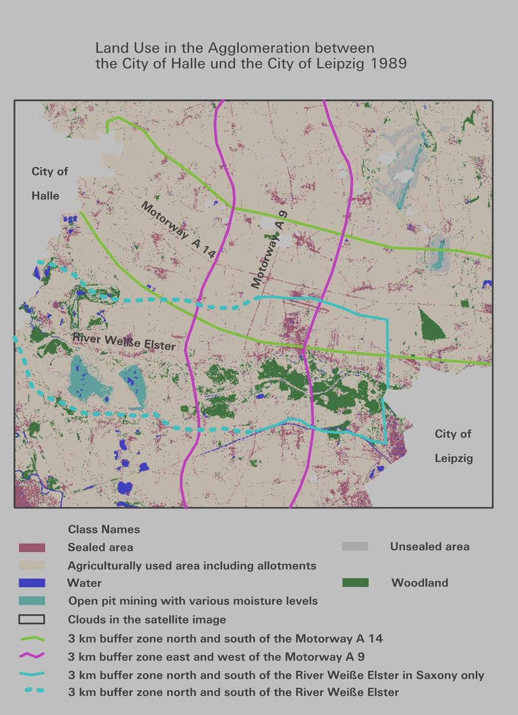
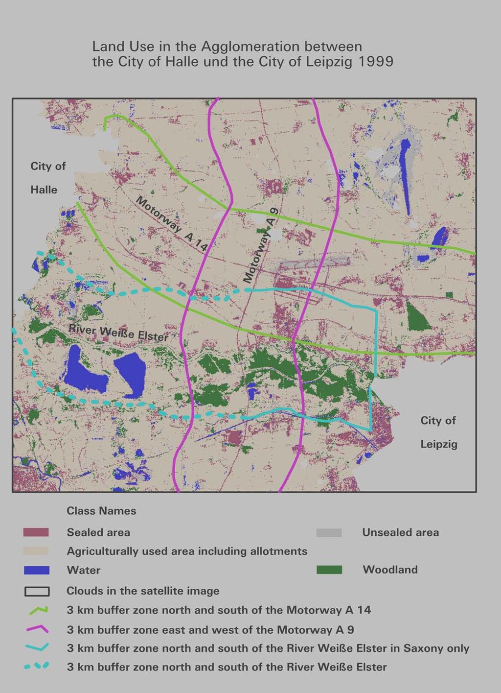
7 First approach Remote sensing data and methods Both classifications, 1989 and 1999, are calculated using the maximum likelihood classifyer with the non-parametric rule of the parallelepiped optimization put first. A hierarchical classifications needs to be generated as different settlement densities and open pit mining are spectrally very similar, as well as fields without crops and unsealed ground (e.g. airport) are difficult to be separated. GIS method 3 km wide buffers each of them subdivided into 100 m distanced zones are created on both sides of important development axes, such as the motorways A 14 and A9, but also for the river Weiße Elster with its floodplain landscape as a recreational axe in-between the two conurbations.
8
9 Results On both sides along the motorway A 14 sealed areas have almost tripled within the first 500 meters. Along the A 9 these areas have doubled in the same zones. Especially large areas have been sealed such as business parks, a new air strip for the airport, a new central market for Leipzig, and further commercial sites with direct access to the motorways. Further away from the motorways new districts play an important role. These are either new appartment or single family houses, or new built commercial sites including shopping centres. The increase of sealed areas is at expense of agricultural land use in first place. Between buffer zones 300 m up to 500 m agriculture decreases by 20 % to 10 %.

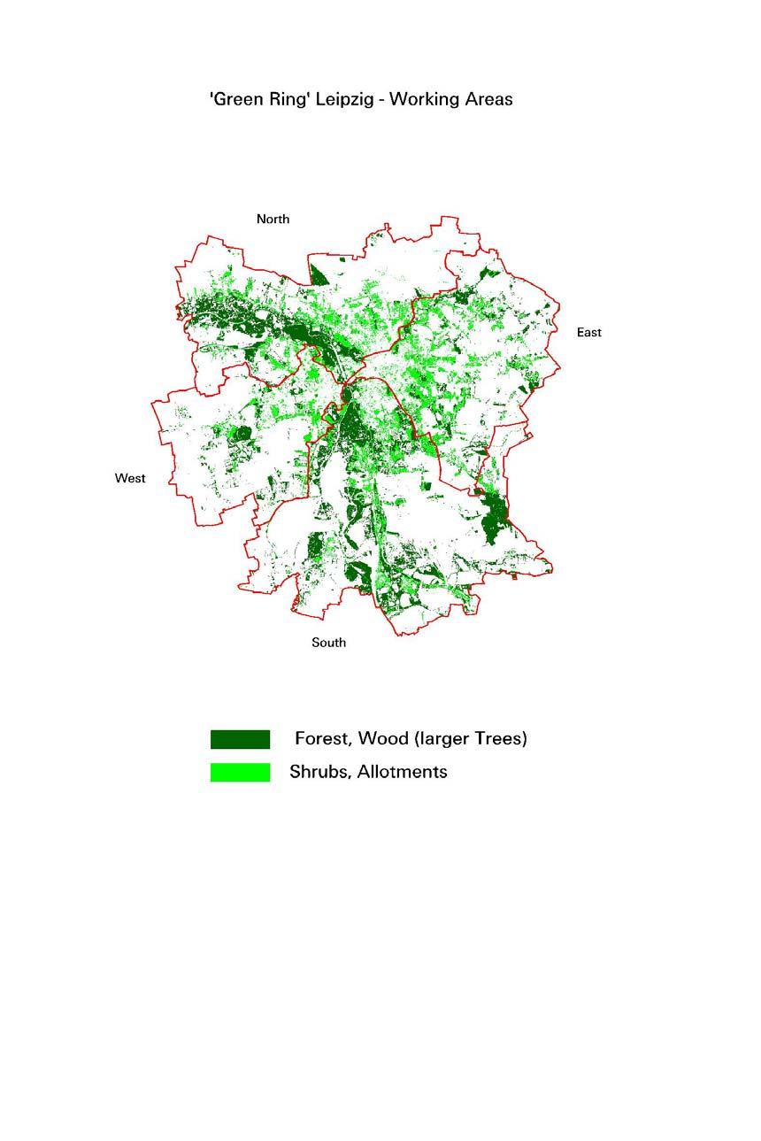
10 Multispectral Classification of Green Structures - IRS-1C Data 1998

11 emphasis on forest and large tree vegetation is in the northwest and south/southwest of the City of Leipzig (area of floodplain forest) the internal ring (5 km) is best equipped with large vegetation large deficits exist in the northern peri-urban area the eastern to southern environment has a higher stand of large vegetation

12 the suburban landscape in total is poorly supplied with small trees and bushes these small trees and bushes are distributed relatively regular around the city an emphasis on small trees and bushes is detectable in the eastern surroundings towards the city centre the highest values appear
13
14 Landscape Structure Metrics Landscape ecology involves the study of landscape patterns, the interactions among patches within a landscape mosaic, and how these patterns and interactions change over time. involves the application of these principles in the formulation and solving of real-world problems. is founded on the notion that the pattern of landscape elements (patches) strongly influences ecological characteristics, including vertebrate populations. The ability to quantify landscape structure is prerequisite to the study of landscape function and change. For this reason, much emphasis has been placed on developing methods to quantify the landscape s structure.
15 Mean patch size (ha) km 10-15km 5-10km 5km Forest, Wood Shrubs, Allotments Water MPS indicates the medium size of the patches and is a function of the total area of the landscape and the number of patches smaller values are a hint for a higher fragmented landscape
16 Largest patch index (%) Forest, Wood Shrubs, Allotments Water 0 20km 15km 10km 5km 15-20km 10-15km 5-10km 5km LPI equals the percentage of the landscape comprised by the largest patch. LPI approaches 0 when the largest patch of the corresponding patch type is increasingly small. LPI = 100 when the entire landscape consists of a single patch of the corresponding patch type; that is, when the largest patch comprises 100% of the landscape. measure for the heterogeneity of the landscape
17 Patch density (#/100ha) Forest, Wood Shrubs, Allotments Water km 10-15km 5-10km 5km PD equals the number of patches of the corresponding patch type (NP) divided by total landscape area, multiplied by 10,000 and 100 (to convert to 100 hectares). facilitates the comparison of landscapes with different sizes
18 Edge density (m/ha) of selected features km 10-15km 5-10km 5km Forest, Wood Shrubs, Allotments Water ED equals the sum of the lengths of all edge segments involving the corresponding patch type, divided by the total landscape area, converted to hectares. strong increase of the edge lengths from the peri-urban area to the city centre
19 Landscape shape index calculated using TE Forest, Wood Shrubs, Allotments Water km 10-15km 5-10km 5km LSI = 1 when the landscape consists of a single patch of the corresponding type and is circular (vector) or square (raster); LSI increases without limit as landscape shape becomes more irregular and/or as the length of an edge increases within the landscape of the corresponding patch type. highest values are in the city fringe
20 Patch density (#/100ha) Forest, Wood Shrubs, Allotments Water 5 0 North East South West Mean patch size (ha) North East South West Forest, Wood Shrubs, Allotments Water
21 Edge density (m /ha) North East South West Forest, Wood Shrubs, Allotments Water Mean nearest-neighbor distance(m) North East South West
Lecture: Landscape Ecology
 Borderland: Border Landscapes Across Europe 2013 Lecture: Landscape Ecology Dr Iwona Markuszewska Department of Landscape Ecology iwmark@amu.edu.pl Presentation schedule: Landscape ecology as a scientific
User Awareness & Training: Use of Copernicus data for land monitoring and environmental reporting in Italy Lisbon, Portugal 14 th February 2014 ISPRA
 User Awareness & Training: Use of Copernicus data for land monitoring and environmental reporting in Italy Lisbon, Portugal 14 th February 2014 ISPRA Contents Introduction to land take, urban sprawl and
The Dreispitz in Basel / Switzerland: New economy on old sites
 The Dreispitz in Basel / Switzerland: New economy on old sites 1. Introduction At 50.000m 2 Dreispitz is currently the largest and most ambitious development project in Basel, the second biggest town in
Nature without barriers
 Nature without barriers Natura2000 sites as Green Infrastructure in the Austrian-Hungarian transborder region Fertö-Hansag-Neusiedlersee Thomas Wrbka Michael Kuttner Univ. Vienna - Department of Biodiversity
RIGA LATVIA. KEY FEATURES OF THE CITY Demographic Facts. Urban Figures. Heritage. EXISTING GOVERNANCE MECHANISMS Development and Management Plans
 RIGA LATVIA KEY FEATURES OF THE CITY Demographic Facts around 700.000 inhabitants in the city 1.15 million people in the Riga region Urban Figures the medieval core of the Old Town the 19th century grid
LAND POTENTIAL EVALUATION FOR LARGE-SCALE GREENBELT DEVELOPMENT AT URBAN-RURAL TRANSITION ZONE A CASE STUDY OF BEIJING, CHINA
 LAND POTENTIAL EVALUATION FOR LARGE-SCALE GREENBELT DEVELOPMENT AT URBAN-RURAL TRANSITION ZONE A CASE STUDY OF BEIJING, CHINA Li Wei-feng*, OUYANG Zhi-yun, WANG Ru-song Key Laboratory of System Ecology,
LAND USE, LAND COVER AND SOIL SCIENCES Vol. IV - Land Use Planning and Managment in Urban and Peri-Urban Areas - H.Vejre
 LAND USE PLANNING AND MANAGEMENT IN URBAN AND PERIURBAN AREAS H.Vejre Department of Economy and Natural Resources, Royal Veterinary and Agricultural University, Denmark Keywords: Urban fringe, Multifunctional
Running head: LAND USE CHANGE IN EDMONTON Land Use Change in Edmonton Chelsey-Ann Cu GEOB 479 L2A
 Running head: LAND USE CHANGE IN EDMONTON 1966-1976 1 Land Use Change in Edmonton 1966-1976 Chelsey-Ann Cu 32482135 GEOB 479 L2A University of British Columbia Dr. Brian Klinkenberg 26 January 2018 LAND
Energy Efficient Strategies for Urban Transportation Planning
 EinT2018 3 rd International Conference ENERGY in TRANSPORTATION 2018 Energy Efficient Strategies for Urban Transportation Planning Prof. Dr. Doaa M. El-Sherif, PhD, Arch. Email: doaa_elsherif@yahoo.com
The urbanization process through urban ecology: which definitions
 Addis Abeba, 1 st November 2014 PhD thesis: The urbanization process through urban ecology: which definitions & which resilience among ecosystems? André M. Introduction: a growing urban population 2 ONU,
THE LANDSCAPE ECOLOGICAL ASSESSMENT MODEL AND ITS APPLICATIONS
 The 5 th International Conference of the International Forum on Urbanism (IFoU) 2011 National University of Singapore, Department of Architecture Global Visions: Risks and Opportunities for the Urban Planet
The Dresden Sustainable Urban Mobility Plan (SUMP)
") The Dresden Sustainable Urban Mobility Plan (SUMP) photo: Frank Fiedler UN-Habitat III Regional Meeting Side-event Sustain and clean mobility for the New Urban Agenda Prague, 16.03.2016 Dipl.-Ing. Frank
The Dresden Sustainable Urban Mobility Plan (SUMP) photo: Frank Fiedler UN-Habitat III Regional Meeting Side-event Sustain and clean mobility for the New Urban Agenda Prague, 16.03.2016 Dipl.-Ing. Frank
Outline of Presentation
 LUSAKA CITY COUNCIL 2 nd Annual IGC Cities Conference Making Cities work for growth London School of Economics (LSE) United Kingdom. 28 th 29 th January 2016 Presenter: Alex Mwansa Town Clerk Lusaka City
Mosaic of patches Agents of patch formation: Environmental constraints (Abiotic) Biotic processes Disturbances (natural and human induced)
 Biotic processes Disturbances (natural and human induced)") Landscape: Mosaic of patches Agents of patch formation: Environmental constraints (Abiotic) Biotic processes Disturbances (natural and human induced) Concepts for Quantification of a Landscape Landscape
Landscape: Mosaic of patches Agents of patch formation: Environmental constraints (Abiotic) Biotic processes Disturbances (natural and human induced) Concepts for Quantification of a Landscape Landscape
Total acreage of Bloomsburg 3,014. Percentage of land used by intensive land uses 49.7% Percentage of land used by open space land uses 42.
 Land Use by the Numbers Total acreage of Bloomsburg 3,014 Percentage of land used by intensive land uses 49.7% Percentage of land used by open space land uses 42.8% Percentage of other lands (water) 7.5%
NEW CASTLE COUNTY S ZONING DISTRICTS
 NEW CASTLE COUNTY S ZONING DISTRICTS This is general information about New Castle County s zoning districts. The information included is by no means exhaustive or complete. Before designing plans to develop
ANALYSIS ON EFFECTS OF SEOUL METROPOLITAN SUBWAY STATION BY USING GIS AND RS
 ANALYSIS ON EFFECTS OF SEOUL METROPOLITAN SUBWAY STATION BY USING GIS AND RS I.T. Yang, S.Y. Lee, S.I. Baek & J.H. Park E-Mail :intae@kangwon.ac.kr Lab. Of Surveying & Geospatial Information Department
Study on Landscape Pattern Based on Landsat-8 in the Center of Chengdu City, China
 Journal of Environmental Protection, 216, 7, 15-156 Published Online June 216 in SciRes. http://www.scirp.org/journal/jep http://dx.doi.org/1.4236/jep.216.7793 Study on Landscape Pattern Based on Landsat-8
Assessing Changes in Green Space of Suzhou City using Remote-Sensing Images and Landscape Metrics
 Assessing Changes in Green Space of Suzhou City using Remote-Sensing Images and Landscape Metrics Hao Xu 1,*, Jing Cui 1 1 College of Landscape Architecture, Nanjing Forestry University Nanjing 210037,
A Network Theory Framework for Urban Cultural Heritage Conservation. Manal Ginzarly LEMA, Université de Liège
 A Network Theory Framework for Urban Cultural Heritage Conservation Manal Ginzarly LEMA, Université de Liège Objective Develop an ecological approach to the integration of heritage conservation and urban
Birmingham. Summer study!!
 Birmingham Summer study!! Urban Change in the UK - Birmingham - Part 1 Location / Facts - Birmingham is located in the centre of England - It is the 2nd largest city with a population of around 1 million
Study on Residential Area Lots and Plans for Green Area in City of Norfolk
 Study on Residential Area Lots and Plans for Green Area in City of Norfolk Makoto TANOUE Graduate Student, The University of Kitakyushu Hiroatsu FUKUDA Professor., Faculty of Engineer, The University of
Improving the Quality of Life in Urban Regions Through Urban Greening Initiatives EU URGE-Project
 00016 Improving the Quality of Life in Urban Regions Through Urban Greening Initiatives EU URGE-Project Richard Coles 1 and Nick Grayson 2 1 Faculty of the Built Environment, University of Central England,
A Bilingual Cooperative Planning Process on the Swiss-French Border in the Basel Area
 A Bilingual Cooperative Planning Process on the Swiss-French Border in the Basel Area 1. Situation The city of Basel is located on the north-western edge of Switzerland. With the borders of France to the
Gather information from online resources covering the following topics:
 Assignment #1: Regional Analysis Project Site Location: Greater Boston Area What comprises a region? The many elements within a region comprise the region as a whole. Natural as well as manmade environmental
WELCOME GYPSY LANE. Wider Site Location plan. Proposals for the development of LAND OFF FOXLYDIATE LANE WEBHEATH. Proposals for the development of
 WELCOME The developers are preparing an outline planning application for a residential led development and need the community s views in order to develop the proposals further WHAT IS PROPOSED? A high
TRANSFORMATION OF RURAL AREAS INTO URBAN AREAS WITHIN THE WARSAW METROPOLITAN AREA IN THE EARLY 21 ST CENTURIES
 Bożena Degórska Institute of Geography and Spatial Organization, Polish Academy of Sciences, Warsaw, Poland bodego@twarda.pan.pl TRANSFORMATION OF RURAL AREAS INTO URBAN AREAS WITHIN THE WARSAW METROPOLITAN
Western Sydney Parklands Australia s Largest Urban Park
 Western Sydney Parklands Australia s Largest Urban Park 37 WLA 1 MAGAZINE 21 38 WESTERN SYDNEY PARKLANDS AUSTRALIA S LARGEST URBAN PARK Large urban parks have dual roles to play in meeting the demands
GREEN INFRASTRUCTURE PLANNING GUIDE
 GREEN INFRASTRUCTURE PLANNING GUIDE Authors: C Davies, R MacFarlane, C McGloin, MRoe. Abbreviation Green Infrastructure is frequently abbreviated to as GI and Green Infrastructure Planning as GIP. Contents
GREEN NETWORK APPLICATIONS IN ESTONIA
 GREEN NETWORK APPLICATIONS IN ESTONIA Kalev Sepp, Tuuli Veersalu, Martk Külvik Estonian University of Life Sciences 1 WHY? BACKGROUND - POLITICAL By adopting the Pan-European Biological and Landscape Diversity
TIDAPA Structure Plan
 TIDAPA Structure Plan Prepared by Tract Consultants 28 MARCH 2017 0217-0074 Table of Contents 01 STRATEGIC CONTEXT Executive Summary Regional Context Page 3 Page 4 02 LOCAL CONTEXT Aerial Photograph Local
The analysis of key visual characteristics and attributes that contribute to variations in the
 15.0 CHIGWELL/CHIGWELL ROW 15.1 Overview 15.1.1 Chigwell and Chigwell Row settlements are situated in the south of Epping Forest District, to the south of Abridge and southwest of Stapleford Abbotts. Both
German ecological network legal base, scientific foundation and international context
 A future task in good hands German ecological network legal base, scientific foundation and international context Dr. Uwe Riecken Federal Agency for Nature Conservation (BfN) Bonn, Germany 9 th Pan-European
Regional Context Statement
 Regional Context Statement REGIONAL CONTEXT STATEMENT 3. REGIONAL CONTEXT STATEMENT In 1995, the Provincial Government passed into law the Growth Strategies Act. The purpose of this provincial initiative
City Development in Israel
 Harry GREENBERG, Israel Key words: Re-survey, Re-evaluate. ABSTRACT City can be defined as an inhabited place (from Latin: civitas), with multipurpose defined areas, many buildings, a large net of infrastructure
EXECUTIVE SUMMARY. Introduction
 Introduction EXECUTIVE SUMMARY The Urban Service Area Fort McMurray (hereafter referred to as the Urban Service Area) is currently experiencing a variety of development pressures. Unprecedented population
THE CHARACTERISTICS ON THE GENERATION OF URBAN FORM OF HANGZHOU COMBINING WITH THE HIGH SPEED URBANIZATION
 The 4 th International Conference of the International Forum on Urbanism (IFoU) 2009 Amsterdam/Delft The New Urban Question Urbanism beyond Neo-Liberalism THE CHARACTERISTICS ON THE GENERATION OF URBAN
Contribution to METREX Barcelona biennial Conference, Workshop 6, Barcelona, October 29th 2004
 Contribution to METREX Barcelona biennial Conference, Workshop 6, Barcelona, October 29th 2004 The Saxon Triangle A Polycentric Region in Transformation Dr. Thorsten Wiechmann Leibniz Institute of Ecological
HOROWHENUA DEVELOPMENT PLAN June create a safe crossing for children moving to and from the school and other areas. 7.8 Ohau
 7.8 Ohau create a safe crossing for children moving to and from the school and other areas. Ohau has a traditional village form with a collective of school, church and reserve at the main road intersection.
Urban planning and Public Transport
 Urban planning and Public Transport MOJCA SASEK DIVJAK Urban Planning Institute of the Republic of Slovenia Trnovski pristan 2, 1000 Ljubljana SLOVENIA e-mail: mojca.sasek@uirs.si; http://www.uirs.si Abstract:
Site Option 3: Te Matai
 Site Option 3: Te Matai Location Napier Drain looking south east Description The Te Matai growth option is located between the existing residential boundary (Ruamahanga Crescent) Napier Road (State Highway
PLACE WORKSHOP REPORT. A+DS SNH sustainable placemaking programme
 PLACE briefing WORKSHOP REPORT A+DS SNH sustainable placemaking programme INTRODUCTION This report summarises the outcome of a Scottish Natural Heritage workshop on placemaking which was held on Wednesday
Chapter 10 The Urban World
 Chapter 10 The Urban World Overview of Chapter 10 Population and Urbanization Characteristics of Urban Population Urbanization Trends City as an Ecosystem Environmental Problems in Urban Areas Environmental
KANPUR 5 LAND USE Final Report: Kanpur City Development Plan Under JNNURM
 5 LAND USE The process of planned development for Kanpur city was started way back in 1943 when Kanpur Development Board has prepared the first development plan. With the change in socio-economic situation
INTRODUCTION PLANNING HISTORY
 INTRODUCTION The Upper Rock Creek Master Plan Area lies in the east central part of Montgomery County. The Master Plan Area is adjacent to the City of Rockville to the south, the Olney Planning Area to
The Research and Prospect of Science of Human Settlements. Shi Yuxue Shanghai Science Institute of Human Settlements
 The Research and Prospect of Science of Human Settlements Shi Yuxue Shanghai Science Institute of Human Settlements Preface A. Scientific research can not do without public participation B. The application
Biodiversity and Urban Streets
 Biodiversity and Urban Streets Urban Street Design for Engineers CPD Session 3 Constituent Elements Engineers Ireland Maryann Harris BSLA MSc Dip Law Past-President, Irish Landscape Institute Parks Services
Landscape Change in a Mountainous Area in Northeastern Portugal: Implications for Management
 WSEAS International Conference on URBAN PLANNING and TRANSPORTATION (UPT'7), Heraklion, Crete Island, Greece, July 22-24, 28 Landscape Change in a Mountainous Area in Northeastern Portugal: Implications
Consequences of Landscape Patterns on Flows of Energy, Nutrients, Organisms
 Consequences of Landscape Patterns on Flows of Energy, Nutrients, Organisms Consequences of Landscape Patterns on Flows of Energy, Nutrients, Organisms Questions: How does landscape structure influence
Case Study of Integrated Housing and Railway Development (Kohoku New Town and Yokohama City Metro Development)
") Case Study of Integrated Housing and Railway Development (Kohoku New Town and Yokohama City Metro Development) Project Division, Urban Development Bureau and Development Cooperation Division, International
Case Study of Integrated Housing and Railway Development (Kohoku New Town and Yokohama City Metro Development) Project Division, Urban Development Bureau and Development Cooperation Division, International
NON-TECHNICAL SUMMARY
 Proposed Sand and Gravel Extraction and Associated Processing Operations with Restoration to a Mixture of Agriculture and Nature Conservation including Areas of Shallow Water at Hedgeley, Northumberland
TOWN OF CALEDON Land Use Study for GTA West Corridor and Adjacent Lands!
 TOWN OF CALEDON Land Use Study for GTA West Corridor and Adjacent Lands! Presentation to Council! March 10, 2015! Why are we here?! 1. The Province has now developed a short list of possible routes for
CaseStudy Climate-ADAPT. Stuttgart: combating the heat island effect and poor air quality with green ventilation corridors
 CaseStudy Climate-ADAPT Stuttgart: combating the heat island effect and poor air quality with green ventilation corridors Cover design: EEA Cover photo: EEA Layout: EEA Legal notice The contents of this
MERIDAN PLAINS SAND RESOURCE AREA
 MERIDAN PLAINS SAND RESOURCE AREA INFORMATION SHEET October 2010 BACKGROUND The Meridan Plains Extractive Resource Area is located on the western fringe of the coastal urban communities of Caloundra West
Dr.- Ing. Andreas Hendricks Land consolidation and land development more than reorganizing land property
 Dr.- Ing. Andreas Hendricks Land consolidation and land development more than reorganizing land property Tartu, May 2015 Structure Structural data Objectives Procedures Main stages and features Costs and
An Integrated Approach to Mitigation Wetland Site Selection: A Case Study in Gwacheon, Korea
 Sustainability 2015, 7, 3386-3413; doi:10.3390/su7033386 Article OPEN ACCESS sustainability ISSN 2071-1050 www.mdpi.com/journal/sustainability An Integrated Approach to Mitigation Wetland Site Selection:
Table of Allocated Housing Sites
 Draft as of 0 November 016 Table of Allocated Housing s Name Green 1 (30, 33, 10, 169, 36/ 100) Barratt s Farm Balsall Common Yes 57 800 Includes existing park. Listed buildings to edge of site. of search
Bangor - Sustainable post industrial land restoration and re-creation of high biodiversity habitats LIFE99 ENV/UK/000211
 Bangor - Sustainable post industrial land restoration and re-creation of high biodiversity habitats LIFE99 ENV/UK/000211 Project description Environmental issues Beneficiaries Administrative data Read
Neighborhood Districts
 NEIGHBORHOOD DISTRICTS SEVEN MAIN DISTRICTS Neighborhood Districts While the Development Plan provides a broad-scale overview of the neighborhood, this section focuses on uses and relationships at the
Chinese-European Cooperation for a Long-term Sustainability Boxundary: A Familiar Phenomena of Suburban Landscapes All Over Europe
 Chinese-European Cooperation for a Long-term Sustainability Boxundary: A Familiar Phenomena of Suburban Landscapes All Over Europe Dóra Hutter, Gyöngyvér Szabó, Anita Szöbölödi, Dániel Takács Corvinus
C. Westerly Creek Village & The Montview Corridor
 C. Westerly Creek Village & The VISION Community Vision When the goals of the city are achieved Westerly Creek Village, a distinctive community defined by Montview Boulevard and Westerly Creek, is a strong
STUDY OF URBAN SMART GROWTH APPROACH BASED ON THE PRINCIPLES AND GUIDELINES FOR NEW PLANNING
 www.arpapress.com/volumes/vol23issue2/ijrras_23_2_05.pdf STUDY OF URBAN SMART GROWTH APPROACH BASED ON THE PRINCIPLES AND GUIDELINES FOR NEW PLANNING Abbas Matloubi Technical and constructive assistant,
Regionalpark RheinMain
 Regionalpark RheinMain A Sense of Landscape - A Feeling for Landscape Sevilla 10.11.2011 Jutta Wippermann The Metropolitan Area Frankfurt/Rhein-Main Frankfurt / Rhein-Main is considered among the leading
OBSERVING THE EXPANSION OF THE BUILT-UP AREAS OF REGIONAL CAPTAIL CITIES IN YANGTZE RIVER DELTA BY SATELLITE IMAGES
 OBSERVING THE EXPANSION OF THE BUILT-UP AREAS OF REGIONAL CAPTAIL CITIES IN YANGTZE RIVER DELTA BY SATELLITE IMAGES Kiyoshi TORII 1), Yoshiaki MORI 1), Zengmin JI 2), Yohei SATO 3), Kuninobu OTSUBO 4)
8.2 Sector 2 Kelburn Park
 8.2 Sector 2 Kelburn Park Kelburn Park, near Victoria University 8.2.1 Character and use Kelburn Park is a sector of the Town Belt, of a scale and character more like a suburban park. However, the woodland
General Manager, Planning and Development; General Manager, Parks, Recreation and Culture. Proposed Mini-Park and Plaza Designations
 Corporate NO: R106 Report COUNCIL DATE: June 16, 2008 REGULAR COUNCIL TO: Mayor & Council DATE: June 12, 2008 FROM: SUBJECT: General Manager, Planning and Development; General Manager, Parks, Recreation
Chapter 1 - General Design Guidelines CHAPTER 1 GENERAL DESIGN GUIDELINES
 CHAPTER 1 GENERAL DESIGN GUIDELINES 1.0 INTRODUCTION This Publication has been developed to provide current, uniform procedures and guidelines for the application and design of safe, convenient, efficient
8.3 Sector 4 Brooklyn Hills
 8.3 Sector 4 Brooklyn Hills Wellington Town Belt on the Brooklyn Hills between Mt Cook and Brooklyn 8.4.1 Character and use This sector extends around the city-facing slopes below Brooklyn, from Mortimer
An evaluation tool for sustainable design of green spaces the URBIO Index
 An evaluation tool for sustainable design of green spaces the URBIO Index Norbert Müller University of Applied Sciences Erfurt, Department Landscape Management and Restoration Ecology, President URBIO
Design Brief. Proposed housing development, White Horse Lane, Trowse FOR. Norfolk Homes
 Design Brief Proposed housing development, White Horse Lane, Trowse FOR Norfolk Homes JOB NO: 10.2812.030 DATE: September 2010 1 Site The Village of Trowse is situated approximate 2 kilometers South East
The Urban Environment
 9 The Urban Environment Overview of Chapter 9 Population and Urbanization Characteristics of Urban Population Urbanization Trends City as an Ecosystem Environmental Problems in Urban Areas Environmental
 Provided by the author(s) and University College Dublin Library in accordance with publisher policies. Please cite the published version when available. Title Encroachment upon protected areas within the
RECREATION, OPEN SPACE AND GREENWAYS ELEMENT GOALS, OBJECTIVES, AND POLICIES
 RECREATION, OPEN SPACE AND GREENWAYS ELEMENT GOALS, OBJECTIVES, AND POLICIES GOAL R-1: DEVELOP A RECREATION, OPEN SPACE AND GREENWAYS SYSTEM AS AN INTEGRAL COMPONENT OF AN OVERALL, COUNTY-WIDE ECONOMIC
Sibbesborg: Competition for Sustainable Community Development
 Sibbesborg: Competition for Sustainable Community Development Pseudonym "Sibblings" Description The urban structure of Sibbesborg is based on a combination of several mutually connected centres. Each of
1. North Rhine-Westphalia. 2. The Ruhr Birthplace of Spatial Planning
 INTERREG IVC - Project "Hybrid Parks" Partner 2: State Chancellery North Rhine-Westphalia Situation Report, April 2012 1. North Rhine-Westphalia In the system of the Federal Republic of Germany, North
Impact of roads on the landscape of a suburban area
 Impact of roads on the landscape of a suburban area D. Marušić & T. Stazić Faculty of Civil Engineering, University of Split, Department for Roads, Croatia Abstract New planned roads change the landscape
CITY OF FREMANTLE LOCAL PLANNING SCHEME NO. 4 AMENDMENT NO. 68 SCHEME AMENDMENT REPORT
 CITY OF FREMANTLE LOCAL PLANNING SCHEME NO. 4 AMENDMENT NO. 68 SCHEME AMENDMENT REPORT CITY OF FREMANTLE PLANNING AND DEVELOPMENT SERVICES 8 WILLIAM STREET FREMANTLE WA 6160 PLANNING AND DEVELOPMENT ACT
DEFINITION, SPECIFICATION AND GIS LAYER CREATION OF LANDSCAPE FEATURES IN SLOVAKIA INCLUDING POSSIBLE SAPS CONSEQUENCES
 DEFINITION, SPECIFICATION AND GIS LAYER CREATION OF LANDSCAPE FEATURES IN SLOVAKIA INCLUDING POSSIBLE SAPS CONSEQUENCES Michal Sviček ek,, Kristína Gasiorková,, Martin Granec Soil Science and Conservation
Jurnal Fikrah Jilid 8, Special Issue 1, , 2017
 Jurnal Fikrah Jilid 8, Special Issue 1, 449-457, 2017 The Role of the Management Method of Endowments on the Supply of the Required Land of Mashhad Municipality A Case Study of the Mashhad City Comprehensive
Section 3b: Objectives and Policies Rural Environment Updated 19 November 2010
 Page 1 of Section 3b 3b RURAL ENVIRONMENT 3b.1 Introduction The Rural Environment comprises all the land outside of the Residential, Town Centre and Industrial Environments. Most land within the District
6 RURAL RESIDENTIAL. 6.1 Rural Use. Rural Use (RU) Goals and Objectives. Policy Goal
 Goals and Objectives. Policy Goal") 6 RURAL RESIDENTIAL The vast majority of East Hants 466,426 acres are considered rural in nature and are characterized by a great diversity of uses. Because of this, land use policies in rural areas of
6 RURAL RESIDENTIAL The vast majority of East Hants 466,426 acres are considered rural in nature and are characterized by a great diversity of uses. Because of this, land use policies in rural areas of
Evolution of the transport connection across the border: the role of the TGV and the future of the lorries. Girona, 2013
 Evolution of the transport connection across the border: the role of the TGV and the future of the lorries Girona, 2013 AIM OF THE REPORT How road and train network has evolved after second World War?
55 years of know how on flame monitoring systems from Leipzig
 55 years of know how on flame monitoring systems from Leipzig From VEB Intron to provider of cutting edge compact flame know how F 300K LAMTEC 55 years of know how on flame monitoring systems from Leipzig
URBAN SMS Soil Management Strategy
 URBAN SMS Soil Management Strategy Baseline scenario analysis Modeling future urban sprawl in pilot cities A. Łopatka, G. Siebielec, A. Żurek, M.Głuszynska, H. van Delden & T. Stuczynski December, 2010
INCREMENTAL CHANGE AREA REVIEW March 2015 Page 1
 INCREMENTAL CHANGE AREA REVIEW March 2015 Page 1 Table of Contents Introduction... 3 Background to Review... 3 Comparison of the Schedules to the General Residential Zone... 7 Methodology... 7 Policy Context...
The Mitigation of UHI Intensity through an Improved Land-Use Plan in the Urban Central Area: Application to Osaka City, Japan
 Academic Article Journal of Heat Island Institute International Vol.7-2 (2012) The Mitigation of UHI Intensity through an Improved Land-Use Plan in the Urban Central Area: Application to Osaka City, Japan
ROLE OF GREEN SPACE IN SUSTAINABLE URBAN ENVIRONMENT: A CASE OF TEHRAN (IRAN)
") ROLE OF GREEN SPACE IN SUSTAINABLE URBAN ENVIRONMENT: A CASE OF TEHRAN (IRAN) Ali Asadi (Ph.D) Assistant Professor of Tehran University Iran aasadi@ut.ac.ir 1 Abstract: Green spaces can improve the urban
ROLE OF GREEN SPACE IN SUSTAINABLE URBAN ENVIRONMENT: A CASE OF TEHRAN (IRAN) Ali Asadi (Ph.D) Assistant Professor of Tehran University Iran aasadi@ut.ac.ir 1 Abstract: Green spaces can improve the urban
Landscape Ecology and Amphibians
 and Amphibians WFS 533 Wyn Miller March 26, 2009 Overview Introduction to landscape ecology Metapopulation dynamics Natural habitat fragmentation Anthropogenic habitat fragmentation landscape ecology Introduction
1Planning. Approach. Part I Chapter 1: Planning Approach
 1Planning Approach Part I Chapter 1: Planning Approach 1 Planning Approach page 5 1Planning Approach The preparation of the Master Plan constitutes a unique opportunity to reflect collectively on the
242 neighborhoods NEIGHBORHOOD 4: JORDAN AVENUE CORRIDOR
 NEIGHBORHOOD 4: JORDAN AVENUE CORRIDOR Aerial View of Jordan Avenue Corridor EXISTING CHARACTER The Jordan Avenue Corridor is the portion of North Jordan Avenue that extends north from East Third Street
City: Introduction and characteristics
 1 City: Introduction and characteristics Index Unit Data Population 1 735 442 Residents 2014 Area 517 km 2 2014 Population density 3 355 Persons/ km 2 2014 GDP 29 153 /per capita 2012 Climate classification
General Manager of Planning, Urban Design and Sustainability
 ADMINISTRATIVE REPORT Report Date: May 2, 2017 Contact: Katherine Isaac Contact No.: 604.873.7167 RTS No.: 10847 VanRIMS No.: 08-2000-20 Meeting Date: May 16, 2017 TO: FROM: SUBJECT: Vancouver City Council
Page 1 of 19 URBAN DESIGN FRAMEWORK FOR BOLTON STREET WATERFORD
 Page 1 of 19 URBAN DESIGN FRAMEWORK FOR BOLTON STREET WATERFORD 1.0 Introduction: The relocation of the City Council stores and depot from Bolton Street creates an exciting opportunity for development
Work Plan for Pilot Action 1: Littoinen and Varissuo with surroundings. Responsibilities concerning the pilot actions:
 Responsibilities concerning the pilot actions: In Turku urban region, there are two project partners, the City of Turku and the Regional Council of Southwest Finland. The responsibilities have been divided
LANDMAP Methodology Overview
 LANDMAP Methodology Overview June 2017 Jill Bullen, Senior Landscape Specialist jill.bullen@cyfoethnaturiolcymru.gov.uk 0300 065 4706 (Please note this is an information document and not a training presentation)
Definitions. Average Daily Traffic Demand (ADT): The actual number or projected number of cars that pass a point in a 24-hour period.
: The actual number or projected number of cars that pass a point in a 24-hour period.") Definitions Access Management: A combination of physical techniques and transportation policies used to control the flow of traffic between roads and the surrounding lands. Alternative City Form Scenarios:
Definitions Access Management: A combination of physical techniques and transportation policies used to control the flow of traffic between roads and the surrounding lands. Alternative City Form Scenarios:
Form Syntax as a contribution to geodesign: a method to measure urban form quantitatively and assist urban design
 Form Syntax as a contribution to geodesign: a method to measure urban form quantitatively and assist urban design YU YE Anthony G. O. Yeh Jianzheng Liu; Tian Lan Akkelies van Nes Henrik Harder introduction:
Land Use Plan. Strategic Plan. CHAPTER SEVEN Proposed Land Use Plan. Fort Washington Area
 CHAPTER SEVEN Proposed Land Use Plan The Proposed Land Use Plan is a significant component of the Comprehensive Plan. It is Whitemarsh s land use policy statement. A policy guide for the township, it is
Growth Management Planning in the Central Puget Sound Region. Today s Presentation. Puget Sound Region. New Partners for Smart Growth
 Growth Management Planning in the Central Puget Sound Region New Partners for Smart Growth Denver, CO January 2006 Today s Presentation Regional growth management in central Puget Sound, WA Regional geographies
Strategic Research Agenda for. High-Altitude Aircraft and Airship. Remote Sensing Applications
 Strategic Research Agenda for USE HAAS High-Altitude Aircraft and Airship Remote Sensing Applications Christian Barbier (CSL, B), Bavo Delauré (VITO, B), Arie Lavie (CTI, Is) 1 OUTLINE 1. The USE HAAS