Staff Report & Draft Supplemental Environmental Impact Statement Amendments to the Pierce County Comprehensive Plan
|
|
|
- Dina Byrd
- 5 years ago
- Views:
Transcription
1 Staff Report & Draft Supplemental Environmental Impact Statement 2013 Amendments to the Pierce County Comprehensive Plan
2
3 Pierce County Department of Planning and Land Services DENNIS HANBERG Director 2401 South 35th Street Tacoma, Washington To: RE: All Interested Parties Staff Report and Draft Supplemental Environmental Impact Statement for 2013 Amendments to the Comprehensive Plan for Pierce County, Washington In an effort to provide better information to the public and reduce duplication, Pierce County Planning and Land Services (PALS) and the Environmental Official have issued a combined Staff Report and Draft Supplemental Environmental Impact Statement (SEIS) which addresses the 2013 amendments to the Comprehensive Plan. The Pierce County Environmental Official has issued this document to provide additional analysis to support information in prior environmental documents prepared for the 1994 Comprehensive Plan and the 1995, 1996, 1997, 1998, 1999, 2001, 2003, 2005, 2006, 2007, 2009, 2011, and 2012 Amendments to the Comprehensive Plan, and the 2004 Growth Management Act Compliance Update to the Comprehensive Plan. This Draft SEIS provides analysis of proposed amendments to the Comprehensive Plan including text amendments, area-wide map amendments, urban growth area amendments, and community plan amendments. Your review and subsequent comments concerning this document are important to ensure that all environmentally significant impacts have been identified. Our department appreciates your timely review and forwarding of comments concerning this Draft SEIS. The deadline for receiving comments regarding this Draft SEIS is August 19, Please address your comments in writing to: Environmental Official, c/o Long Range Planning Division, Room 228, Pierce County Planning and Land Services, 2401 South 35th Street, Tacoma, WA A Final SEIS, which summarizes and responds to the comments received, will be issued subsequent to the end of the comment period. You will receive notification of availability of the Final SEIS if you are on our mailing list or if you have provided your name and address to department staff when picking up your copy of the Draft SEIS. If you have questions concerning the Staff Report and Draft SEIS, please contact Jeff Mann at (253) or jmann@co.pierce.wa.us. I appreciate your assistance in reviewing this document for accuracy and completeness. Thank you. Sincerely, Dennis Hanberg Director, Planning and Land Services
4
5 STAFF REPORT AND DRAFT SUPPLEMENTAL ENVIRONMENTAL IMPACT STATEMENT for 2013 AMENDMENTS TO THE PIERCE COUNTY COMPREHENSIVE PLAN PIERCE COUNTY DEPARTMENT OF PLANNING AND LAND SERVICES Dennis Hanberg, Director 2401 South 35th Street Tacoma, Washington 98409
6
7 TABLE OF CONTENTS TABLE OF CONTENTS... i FACT SHEET... iv SUMMARY...1 Proposed Action...1 Alternatives Considered...1 State Environmental Policy Act...2 Impacts and Mitigation Measures...2 PROPOSED TEXT AMENDMENTS...3 Organization...3 T-1 UGA Policy Amendment...3 General Description...3 Text Amendment...4 Impact Analysis...6 Staff Recommendation...8 Implementation Requirements...8 T-2/C-2/M-6 Rural Neighborhood Centers (RNC); Additional RNC (Gig Harbor Peninsula Community Plan); Rural 10 (R10) To Center (RNC)...8 General Description...8 Text Amendment...8 Impact Analysis...15 Staff Recommendation...20 Implementation Requirements...24 Cumulative Analysis Text Amendments...30 Impacts Proposed Action...30 Impacts No Action Alternative...30 Impacts Staff Recommendation Alternative...31 Mitigation Measures...31 Unavoidable Impacts...31 PROPOSED AREA-WIDE MAP AMENDMENTS...31 Organization...31 M-1 Change Park & Recreation (PR) Designations to Prior Designations...31 General Description...31 Impact Analysis...32 Staff Recommendation...38 Implementation Requirements...38 i
8 M-2 Rural Ten (R10) to Park & Recreation Designation (PR) and Park & Recreation (PR) to Moderate Density Single Family (MSF)...38 General Description...38 Impact Analysis...38 Staff Recommendation...41 Implementation Requirements...41 M-3 Change Park & Recreation (PR) Designations to Moderate Density Single Family (MSF)...42 General Description...42 Impact Analysis...43 Staff Recommendation...44 Implementation Requirements...44 M-4 Agricultural Resource Lands (Arl) To/From Various Designations...47 General Description...47 Impact Analysis...48 Staff Recommendation...52 Implementation Requirements...52 M-5 Key Peninsula Metro Parks - Park & Recreation (PR) Designation...55 General Description...55 Impact Analysis...55 Staff Recommendation...58 Implementation Requirements...59 M-6 See T-2/C-2/M-6 Cumulative Analysis Area-Wide Map Amendments...63 Impacts Proposed Action...64 Impacts No Action Alternative...64 Impacts Staff Recommendation Alternative...64 Mitigation Measures...64 Unavoidable Impacts...64 Implementation Requirements...64 PROPOSED URBAN GROWTH AREA AMENDMENTS...65 Organization...65 Environmental Documentation...65 U-1 City of Bonney Lake UGA Expansion...65 General Description...65 Impact Analysis...65 Staff Recommendation...72 Implementation Requirements...72 ii
9 U-2 Technical Amendments - Annexations...76 General Description...76 Impact Analysis...76 Staff Recommendation...77 Implementation Requirements...77 Cumulative Analysis Urban Growth Area Amendments...77 Impacts Proposed Action...77 Impacts No Action Alternative...78 Impacts Staff Recommendation Alternative...78 Mitigation Measures...78 Unavoidable Impacts...78 Implementation Requirements...78 PROPOSED COMMUNITY PLAN AMENDMENTS...78 Organization...78 C-1 Sleeger Wine Production in RSR - Gig Harbor Community Plan...78 General Description...78 Text Amendment...79 Impact Analysis...80 Staff Recommendation...82 Implementation Requirements...83 C-2 See T-2/C-2/M-6 Cumulative Analysis Community Plan Amendments...83 Impacts Proposed Action...83 Impacts No Action Alternative...83 Impacts Staff Recommendation Alternative...83 Mitigation Measures...84 Unavoidable Impacts...84 LIST OF APPENDICES Appendix A: Appendix B: Amendment Maps Distribution List iii
10 FACT SHEET Title and Description of Proposed Action The 2013 adoption of amendments to the Pierce County Comprehensive Plan by the Pierce County Council is a non-project action. The Pierce County Comprehensive Plan was adopted in November 1994 and consists of objectives, principles, and standards which provide a framework for directing growth and land uses through the next 20 years. The Plan was prepared in compliance with the requirements of Washington's Growth Management Act. The initiated 2013 amendments were identified by the Pierce County Council in Resolution No. R2013-8s. This integrated Staff Report and Draft Supplemental Environmental Impact Statement is intended to address the implications and impacts of four types of amendments: text amendments, area-wide map amendments, urban growth area amendments, and community plan amendments. In addition to the Proposed Action, alternatives considered in the Draft SEIS include the No Action Alternative and a Staff Recommendation Alternative. Proponent Tentative Adoption Date Pierce County Planning and Land Services Department Planning Commission hearings were held in July, 2013 at 7:00 p.m. in the Pierce County Public Services Building Public Meeting Room, located at 2401 South 35th Street, Tacoma. County Council hearings are not scheduled at this time but are expected to begin in August, Final adoption of the 2013 amendments by the Pierce County Council is anticipated to occur in the fall of Council hearings are held in Room 1046 of the County-City Building, 930 Tacoma Avenue South, Tacoma. iv
11 Lead Agency Pierce County Planning and Land Services Department 2401 South 35th Street Tacoma, WA Responsible Official: Dennis Hanberg, Director Planning and Land Services Department (253) Contact Person: Jeff Mann, Associate Planner Planning and Land Services Department (253) or (253) Facsimile Authors and Principal Contributors Planning and Land Services Department Date of Draft SEIS Issuance: Date Comments are Due: August 19, 2013 Environmental Review Process Location of Background Material and Documents Incorporated by Reference Pierce County has used a phased-review process for the non-project actions required by Washington's Growth Management Act, including the Comprehensive Plan and Development Regulations - Zoning. Pierce County intends to continue to use this phased-review for adoption of amendments to the Comprehensive Plan and development regulations that implement the Plan. Background material and documents used to support development of the Staff Report and Draft SEIS are available for inspection at the Pierce County Planning and Land Services Department, Room 228, 2401 South 35th Street, Tacoma, WA 98409, (253) v
12 Relation to Other Documents SEIS Cost to the Public A series of environmental documents has been prepared by Pierce County to evaluate the impacts of the Pierce County Comprehensive Plan and amendments to the Plan. These documents, listed in the Summary Section of this Draft SEIS, are incorporated by reference. Pierce County intends to continue to use a phased environmental review approach for analyzing Comprehensive Plan amendments or other GMA documents related to the Comprehensive Plan or Development Regulations. Additional environmental documentation, in the form of supplemental EISs, addenda, or other SEPA determinations may be made as the Pierce County Comprehensive Plan is further implemented. This document is not intended to satisfy individual project SEPA requirements. A limited number of copies of the Draft SEIS are available at no charge from the Pierce County Planning and Land Services Department. Copies are available for review at the Department and at libraries throughout the County. vi
13 SUMMARY This Staff Report and Draft Supplemental Environmental Impact Statement (Draft SEIS) analyzes the probable significant adverse impacts of the proposed 2013 amendments to the Comprehensive Plan for Pierce County, Washington. The Draft SEIS is intended to provide information to decision-makers and the public on the potential impacts of the plan amendments and impacts of alternative courses of action. This Draft SEIS is a supplement to previously prepared environmental documents for the Comprehensive Plan. A table that lists environmental documents prepared to date can be viewed at on the environmental page or at the Planning and Land Services Department. The information and analyses contained in the environmental documents described in the table identify the environmental impacts associated with the Comprehensive Plan and implementing regulations. For a full disclosure of impacts associated with the Comprehensive Plan, these documents should also be consulted. Individual applications can be reviewed at PROPOSED ACTION The Proposed Action is the adoption of amendments to the Pierce County Comprehensive Plan. The Comprehensive Plan, originally adopted in November 1994, is a policy document which guides growth and future land use decisions in Pierce County. The Plan was developed to address growth over a 20-year period. The proposed amendments are divided into four distinct groupings: 1) Text Amendments: proposed changes to the written text or policy in the Comprehensive Plan. Two text amendments are proposed. 2) Area-wide map Amendments: changes to mapped land use designations in the Comprehensive Plan's Generalized Proposed Land Use Map. Six area-wide map amendments are proposed. 3) Urban Growth Area/Urban Service Area Amendments: proposed changes to the boundaries of city Urban Growth Areas and Urban Service Areas. There is one UGA request and one technical action to amend County land use maps to reflect recent annexations to Cities in the County. 4) Community Plan Amendments: proposed changes to the written text or policy in an adopted community plan. Two community plan amendments are proposed. The impacts of each individual amendment proposal are identified in this document. Also included is an analysis of the cumulative impacts of each of the amendment types discussed above. ALTERNATIVES CONSIDERED This Draft SEIS considers the Proposed Action and two alternatives: the No Action Alternative and a Staff Recommendation Alternative. Under the No Action Alternative, no amendments would be enacted; the Comprehensive Plan would remain unchanged. Under the Staff Recommendation Alternative only select amendments would be adopted. These amendments were based on Pierce 1
14 County Planning and Land Services staff recommendations to the Pierce County Planning Commission. STATE ENVIRONMENTAL POLICY ACT The State Environmental Policy Act (SEPA) allows environmental review of proposals to be phased. This phased review allows decision-makers and the public to focus on issues that are ready for decisions while excluding from consideration those issues already decided or not yet ready (WAC (5)(b)). Pierce County has used this phased review to analyze issues related to its Comprehensive Plan and Development Regulations. As amendments are proposed, appropriate environmental analysis will be conducted. This could include adoption of existing environmental documents, addenda, supplemental EISs, or Determinations of Nonsignificance. IMPACTS AND MITIGATION MEASURES Environment Impacts Table 1 provides a summary of impacts of the Proposed Action and Alternatives. Table 1. Environmental Impacts of Proposed Action and Alternatives Proposed Action No Action Alternative Staff Recommendation Alternative Text Amendments No New Impacts No New Impacts Same as Proposed Action Area-Wide Map Amendments No New Impacts No New Impacts No New Impacts UGA/USA Amendments No New Impacts No New Impacts Same as Proposed Action Community Plan Amendments No New Impacts No New Impacts Same as Proposed Action Changes in Land Use Designation 1) Area-wide Map Amendments The potential changes in land use designation for the Proposed Action and the Staff Recommendation Alternative are summarized in Table 2. Table 2. Area-Wide Map Amendments Acreage By Land Use Designation DESIGNATION CHANGE IN ACRES: PROPOSED ACTION CHANGE IN ACRES: STAFF RECOMMENDATION URBAN DESIGNATIONS Moderate Density Single Family * No change from Proposed Action RURAL AND RESOURCE LANDS DESIGNATIONS Rural 10 +9, No change from Proposed Action Rural 20 +1,288 No change from Proposed Action Reserve No change from Proposed Action Rural Separator +105 No change from Proposed Action 2
15 DESIGNATION Table 2. Area-Wide Map Amendments Acreage By Land Use Designation CHANGE IN ACRES: PROPOSED ACTION 3 CHANGE IN ACRES: STAFF RECOMMENDATION Rural Sensitive Resource No change from Proposed Action Park & Recreation acres less Parks and Recreation from M-5(Map 1 of 5) Rural Neighborhood Center No change from Proposed Action Agricultural Resource Land -11,277** No change from Proposed Action Rural Farm +38 No change from Proposed Action *Seventy-five (75) acres owned by Pierce County Public Works and to remain in public ownership. **Technical correction lands did not meet ARL criteria when Land Use Designation map was amended in ) UGA/USA Amendments The UGA/USA Amendments will not result in the change of land use designation. 3) Community Plan Designations Amendments The C-1 Community Plan amendment would add a use to the Rural Sensitive Resource (RSR) designation but would not change any designation. The C-2 Community Plan amendment would add an additional area of Rural Neighborhood Center (RNC) land use designation in the Gig Harbor Peninsula Community Plan area. The Staff Recommendation Alternative incorporates different policy language that supports the designation of the area as an RNC. Mitigation Measures for the Proposed Action No mitigation measures needed or proposed. PROPOSED TEXT AMENDMENTS ORGANIZATION Text Amendments are changes or revisions in the text of the History and Background portion of the Comprehensive Plan (Title 19), and the goals, policies, objectives, principles, or standards of any element of Title 19A of the Comprehensive Plan. T-1 COMPREHENSIVE PLAN TEXT AMENDMENT, Urban Growth Area (UGA) Initiated by: Pierce County Executive Applicant: Pierce County Planning and Land Services General Description This proposal is to amend the policies of the Comprehensive Plan Land Use Element, Title 19A Urban Growth Areas (UGA) to be consistent with the recently amended Countywide Planning Policies (CPPs) specifically the approved changes to Policy AT-2.3. Countywide Planning Policy AT-2.3 The urban growth area of a jurisdiction may be expanded only if:
16 2.3.1 the jurisdiction s observed development densities are consistent with the planned density assumptions as documented in the most recently published Buildable Lands Report as required by RCW 36.70A.215, and there is a demonstrated need for additional residential or employment capacity within the urban growth area affiliated with an individual jurisdiction and a demonstrated need county-wide; or the expansion results in a no net gain to the countywide UGA. (emphasis added) the consistency evaluation, as required through the Countywide Planning Policies on Buildable Lands, policies BL-3. And BL-4., identifies an inconsistency between the observed and planned densities, the jurisdiction shall either: (emphasis added) 1) demonstrate reasonable measures were adopted to rectify the inconsistencies. Documentation shall also be submitted that summarizes the monitoring results of the effectiveness of the measures in rectifying density inconsistencies, or 2) document updated development data that indicates consistency. The proposal clarifies that an urban growth area amendment shall be approved only if there is a demonstrated Countywide need for additional residential or employment capacity or the expansion results in a no net gain to the Countywide UGA. They also clarify that there must a consistency evaluation regarding observed and planned densities. The Pierce County Council approved the CPP policy changes under Ordinance No s on July 19, Proposed Text Amendment The proposed text amendment will revise Section 19A of the Land Use Element regarding Urban Growth Areas. Existing Section 19A H.1.a will need to be deleted due to the clarification in the CPPs. The proposed text amendment will amend Section 19A H to provide consistency with Countywide Planning Policies AT and In addition, Section 19C which regulates Comprehensive Plan amendments will be revised to include language clarifying that it is both residential and employment land capacity that must be evaluated as part of a UGA expansion amendment. Land Use Element - 19A Urban Growth Areas. H. LU-UGA Objective 6. Provide criteria and priorities for the expansion of urban growth areas. 1. Expansions of the Comprehensive Urban Growth Area (CUGA) and satellite urban growth areas shall be approved by the County Council through a Comprehensive Plan amendment process as established in Chapter 19C.10 PCC, only if the following criteria are met: a. Residential land capacity within all urban growth areas is evaluated and the need for additional residential land capacity within all or any specific urban growth area is clearly demonstrated and the observed development densities are 4
17 consistent with the density assumptions as documented in the most recent published Buildable Lands Report as required by RCW 36.70A.215. a. There is a demonstrated need for additional residential or employment capacity within the urban growth area affiliated with an individual jurisdiction and a demonstrated Countywide need; or the expansion results in a no net gain to the Countywide UGA; and b. The jurisdiction s observed development densities are consistent with the planned density assumptions as documented in the most recently published Buildable Lands Report as required by RCW 36.70A.215; and c. If the Buildable Lands Report identifies an inconsistency between the observed and assumed densities, the jurisdiction shall either: (1) demonstrate reasonable measures were adopted to rectify the inconsistency, or (2) document updated development data that indicates consistency. If a jurisdiction adopted reasonable measures, documentation shall be submitted that summarizes the monitoring results of the effectiveness of the measures in rectifying density inconsistencies. and/or b. The supply of land needed for additional commercial/industrial uses outside urban growth areas is clearly demonstrated; and cd. Documentation that adequate public facilities and services can be provided within the 20-year planning horizon is provided. de. Proposed UGA expansion areas shall be required to comply with the requirements of Pierce County s TDR/PDR Program. ef. Proposed UGA expansion areas should be approved only if the proposing jurisdiction provides an analysis of: (1) the underdeveloped lands, consistent with the Pierce County Buildable Lands program methodology, within its existing municipal boundaries and affiliated UGAs, and evidence of implementation strategies in place or being pursed to densify the underdeveloped lands; (2) housing goals or policies in place to encourage housing for all economic segments of the community; and (3) how the proposal is consistent and reasonable with the jurisdiction s adopted comprehensive plan. fg. Future UGA expansion areas should be approved only if it is demonstrated that the area has the capability and capacity to provide urban level services to the area while maintaining a healthy natural ecosystem. gh. Future UGA expansion areas should avoid the inclusion of designated agricultural lands and critical areas, unless (a) otherwise permitted by the applicable community plan, or (b) the development rights are removed. hi. Adopted land use and design standards for proposed UGA expansion areas shall plan for design characteristics and infrastructure necessary to make transit a viable transportation alternative. ij. Prohibit the expansion of the UGA into the one hundred year floodplain of any river or river segment per RCW. 5
18 Comprehensive Plan Procedures 19C F. Urban Growth Area Amendments. If the most recent Buildable Lands Report indicates that no additional residential land capacity is needed, one of the following shall be required: 1. Supplemental information updating population and development trends or documentation of regulatory changes implemented since the completion of the most recent Buildable Lands Report that justifies the need within the Countywide context to expand the Urban Growth Area; or 2. A companion application for reducing the Urban Growth Area in another location to ensure that the amount of residential or employment land capacity is not increased. The properties proposed for removal from the Urban Growth Area must be contiguous with the Urban Growth boundary and be rural in character with existing rural densities. 3. Documentation that the proposed UGA application does not increase the Countywide residential or commercial/industrial employment capacity. Impact Analysis Procedures for Amendments to the Comprehensive Plan, PCC 19C.10, requires all amendments to the Plan to be reviewed against ten criteria (PCC 19C B.). Those criteria, and staff evaluation, are as follows: Effect on rate of growth, development, and conversion of land as envisioned in the Plan The proposed text amendment will not impact the rate of growth, development, or conversion of land as envisioned in the Plan. The amendment will provide additional support for the integrity of the UGA by requiring a demonstration of a Countywide need for additional residential and employment lands versus the demonstration of localized need. Effect on the County's capacity to provide adequate public facilities The proposed text amendment will not impact the County s capacity to provide adequate public facilities. Effect on the rate of population and employment growth The proposed text amendment will not impact the rate of population or employment growth. The UGA has been shown to have sufficient buildable lands for the 20 year horizon of development and therefore should allow the rate of population or employment envisioned by the Regional Growth Strategy and the Pierce County Comprehensive Plan. Whether Plan objectives are being met as specified or remain valid and desirable The proposed amendment will bring consistency with the adopted Countywide Planning Policies and will meet the goals and objectives of the Pierce County Comprehensive Plan. Specific applicable goals and objectives include: 6
19 19A Goals. The following goals, as set forth in RCW 36.70A.020, are adopted to guide development and adoption of Pierce County's comprehensive plan and development regulations. The goals are not listed in order of priority. A. Urban Growth. Encourage development in urban areas where adequate public facilities and services exist or can be provided in an efficient manner. B. Reduce Sprawl. Reduce the inappropriate conversion of undeveloped land into sprawling, low-density development. 19A Urban Growth Areas. C. LU-UGA Objective 2. Provide efficient government facilities and services. 1. Contain and direct growth within the designated Comprehensive Urban Growth Area or satellite city and town UGAs where adequate public facilities exist or can be efficiently provided. H. LU-UGA Objective 6. Provide criteria and priorities for the expansion of urban growth areas. The intent of the amendment is consistent with the Goals and Objectives of the Plan to preserve the integrity of the UGA and providing criteria for its expansion. Effect on general land values or housing costs The proposed text amendment will not impact general land values or housing costs. Whether capital improvements or expenditures are being made or completed as expected No capital improvements are necessary relative to this proposal. Whether the amendment conforms to the requirements of the GMA, is internally consistent with the Plan and is consistent with the Countywide Planning Policies The amendment is consistent with GMA, the Comprehensive Plan, and the Countywide Planning Policies. Effect on critical areas and natural resource lands The proposed text amendment will not impact critical areas or natural resource lands. Consistency with locational criteria in the Comprehensive Plan and application requirements established by Chapter 19C.10 Locational criteria in the Comprehensive Plan are not applicable to this proposal. The submitted application meets all application requirements established by Chapter 19C.10. Effect on other considerations The existing policy allows for the expansion of the UGA if it can be demonstrated that there is insufficient residential lands within all or any specific urban growth area allowing for an argument to be made for UGA expansion based on a demonstration of lands needed in a specific area versus making a Countywide determination. The proposed policy also clarifies the need to evaluate lands that would support employment. The amendment further clarifies the Countywide 7
20 assessment that must take place and also expands the evaluation to residential and employment lands. Staff Recommendation Staff recommends approval of the proposed text amendment. Implementation Requirements Implementation of this amendment will require amending the Pierce County Comprehensive Plan in Titles 19A and 19C. T-2 / C-2 / M-6 RURAL NEIGHBORHOOD CENTERS; ADDITIONAL RNC GIG HARBOR PENINSULA COMMUNITY PLAN; RURAL 10 (R10) to RURAL NEIGHBORHOOD CENTER (RNC) Initiated by: Pierce County Council R2013-8s Applicant: L 80 LLC General Description This proposal combines a text amendment, community plan amendment, and area-wide map amendment as follows: This proposal amends the text of the Comprehensive Plan Land Use Element, Title 19A Rural Centers to modify the criteria for the establishment of a Rural Neighbor Center (RNC). The text amendment would modify the criteria for the establishment of an RNC area Countywide. The text amendment is requested with the intent to allow an RNC designation for the area collectively known as Fisherman s Village located south of the City of Gig Harbor. The applicant has also requested an amendment to the Gig Harbor Peninsula Community Plan (community plan amendment C-2) modifying plan policies to identify the Fisherman s Village area as a new RNC and an area-wide map amendment (M-6) to apply the designation to the subject parcels. Proposed Text Amendment The requested text amendment would revise several sections of Section 19A of the Land Use Element regarding Rural Neighborhood Centers. The following table shows the requested changes: Existing Text 19A A.3 To provide an alternative to strip developments along arterials and state routes; Proposed Text Changes Add a new policy 19A A.6: Allow for existing rural areas of more intense development to be designated as Rural Centers if consistent with the LAMIRD standards of RCW 36.70A.070 8
21 Existing Text 19A G.4 New Rural Neighborhood Centers should be located no closer than two miles from any satellite city Urban Growth Area or the Comprehensive Urban Growth Area boundary unless the proposed Rural Neighborhood Center would be at least two miles from the applicable Urban Growth Area Boundary by way of the existing road network due to a significant topographic feature, e.g., body of water, cliff; etc. 19A I Rural Neighborhood Centers should be limited to no more than 10 acres in size. This limitation shall not apply to a community plan prepared or updated after January 1, New development within Rural Neighborhood Centers should retain a scale and intensity that is appropriate for maintaining rural character. 19A I.1 Commercial development in continuous strips shall be discouraged. Proposed Text Changes Delete this policy: 19A G.4 New Rural Neighborhood Centers should be located no closer than two miles from any satellite city Urban Growth Area or the Comprehensive Urban Growth Area boundary unless the proposed Rural Neighborhood Center would be at least two miles from the applicable Urban Growth Area Boundary by way of the existing road network due to a significant topographic feature, e.g., body of water, cliff; etc. Add language: Rural Neighborhood Centers should be limited to no more than 10 acres in size, except for Centers consistent with the LAMIRD standards of RCW 36.70A (d). This limitation shall not apply to a community plan prepared or updated after January 1, New development within Rural Neighborhood Centers should retain a scale and intensity that is appropriate for maintaining rural character. Add language: Commercial development in continuous strips shall be discouraged, except for Centers consistent with the LAMIRD standards of RCW 36.70A (d). Proposed Community Plan Amendment The requested community plan amendment would revise several sections of the Gig Harbor Peninsula Community Plan to add the Fisherman s Village area as a new RNC. The following table shows the requested changes: Gig Harbor Peninsula Community Plan Amendments Proposed Text Existing Text Land Use Element, page 51, Overview: Two new RNC designations would be added to recognize the existing development pattern at Rosedale and Arletta. Land Use Element, page 51, Commercial: The development possibilities are limited however, based on a five-acre maximum size for these neighborhood commercial centers. Revise: Two Three new RNC designations would be added to recognize the existing development pattern at Rosedale and Arletta and the Fisherman's Village area. Delete the sentence in entirety: The development possibilities are limited however, based on a five-acre maximum size for these neighborhood commercial centers. 9
22 Gig Harbor Peninsula Community Plan Amendments Proposed Text Existing Text Land Use Element, page 52, Proposed Designations (Table 8): Rural-10 acres14,566 RNC acres 9 Land Use Element, page 53, Rural Neighborhood Center (RNC): RNCs are not permitted to exceed five acres in size. Land Use Element, page 53, Rural Neighborhood Center (RNC): The three RNCs in the plan area are located on Fox Island, Rosedale, and Arletta. Land Use Element, page 54, Intent:... historic communities such as Arletta, Rosedale and Fox Island shall be recognized... Land Use Element, page 54, Objective 6: Those historic community centers located at Arletta, Rosedale and Fox Island are recognized as important neighborhood civic and commercial focal points in the rural area. Land Use Element, page 55, Standard Any future expansion of the land utilized as a RNC shall be on those parcels immediately adjacent to the existing centers. Under no circumstances shall an RNC exceed five acres in size. New Standard (6.1.4): Any new RNC shall only be established if consistent with the LAMIRD standards of RCW 36.70A.070 Land Use Element, page 72, bottom of page: area consistent with the community plan policies. Change acreage to reflect amendment: Rural-10 acres14,566 14,550 RNC acres 9 25 Delete the sentence in entirety: RNCs are not permitted to exceed five acres in size. Revise: The three four RNCs in the plan area are located on Fox Island, Rosedale, and Arletta, and the Fisherman's Village area. Revise:... historic communities and established commercial areas, such as Arletta, Rosedale, and Fox Island and the Fisherman's Village area shall be recognized... Revise: Those historic community centers located at Arletta, Rosedale, and Fox Island, and the Fisherman's Village area are recognized as important neighborhood civic and or commercial focal points in the rural area. Revise: Any future expansion of the land utilized as a RNC shall be on those parcels immediately adjacent to the existing centers. Under no circumstances shall an RNC exceed five acres in size. Add a new bullet: Designate the Fisherman's Village area as an RNC Proposed Area-wide Map Amendment The area-wide map amendment redesignates six parcels totaling 16.5 acres from Rural 10 (R10) to Rural Neighborhood Center (RNC) within the Gig Harbor rural area. The proposed map amendment area includes the Gateway Business Park, the Howe Investment business park, and contractor yard located on three of the parcels. The other three parcels are currently vacant and undeveloped. All sites are located between Jahn Avenue NW and State Route (SR) 16. The properties are located north of the 24 th Street NW interchange on SR-16. All properties are currently designated Rural 10. The following information is provided for each parcel in the proposed RNC area: 10
23 Property Parcel Number Current Use/Development Acreage Gateway Point Business Park TW LLC Parcel # The business park was permitted by Site Plan Review (SPR) and allowed eight (8) commercial buildings with a variety of offices and business uses. The first building permit was applied for Building A on November 18, 1991, and was built and finaled on August 4, L 80 LLC Parcel # Vacant and Undeveloped 1.83 Howe Investment business park Parcel # Howe Investment contractor yard/office Howe Investment parcel Holsinger property Parcel # The buildings were constructed and have been utilized for business purposes since approximately The site consists of 2 buildings which have car-related and gymnastic training businesses located in the buildings. The office building for a contractor s yard was constructed in the 1970s and is currently being used for chemical manufacturing. The County is currently working with the property owner on fire access issues. Parcel # Vacant and Undeveloped 1.56 Parcel # Vacant, Uninhabitable house 1.89 Surrounding Land Use North - Attached single-family homes in seven fourplexes, 28 units. South - Mobile home park, 24 th Street NW/SR-16 interchange. East - SR-16 and Narrows Bridge toll booth lanes and structure. West - Jahn Avenue NW, Single-family subdivisions with landscape buffers. Planning History Affecting the Area Gig Harbor Comprehensive Plan and Development Regulations On June 30, 1975, Pierce County adopted the Gig Harbor Peninsula Comprehensive Plan and Development Regulations. The Plan included an innovative approach to land use planning by designating the Plan area with eight environments. This Plan and the attendant Development Regulations designated the area on the west side of SR-16 just north of the Narrows Bridge, including the subject area, as an Urban Environment with the following Definition and Purpose: The urban environment is a clearly delineated area of relatively high intensity land use which may include residential, commercial, industrial and other types of development. It is an environmental designation that is.29 11
24 suitable only for those areas which are already subjected to relatively high intensity land use and or areas which are services by high volume arterials, areas easily supplied with utility services adequate to handle high intensity use. The urban environment, while providing for relatively high intensity land use, will, by the nature of its architecture and landscaping, blend with the rural, natural atmosphere of the larger peninsula. The Development Regulations further clarified in defining the purpose of the Urban Environment: In furtherance of the Comprehensive Plan, the Urban Environment is intended to designate areas where use of high intensity and density are encouraged to locate Areas of the community designated urban are those which have been found to possess the capability to absorb more intense uses of the land because of their orientation to major streets and highways(emphasis added) and the availability of adequate utility service. The Gig Harbor Comprehensive Peninsula Plan and Development Regulations were in effect from 1975 to Howe Investment Properties The northerly two parcels within the area of the proposed redesignation have light industrial/commercial buildings which were built in the 1970s and 1980s. These developments were recognized in the designation of the area as an Urban Environment. Fisherman s Village (Gateway Pointe Business Park) The Fisherman s Village (now Gateway Pointe Business Park) was approved as part of Site Plan Review (SPR) on November 10, 1989, by the Pierce County Hearing Examiner. The approval allowed the construction of eight retail building totaling 60,992 square feet. The findings of the staff report and the decision by the Hearing Examiner were based in part by the designation of the area as Urban Environment and the assessment of the built environment at that time. The staff report indicated the following land uses and environment designations at the time (1989): Land Use North- Vacant, wooded/commercial South Mobile home park East SR-16 West Vacant- Residential Environment Urban Urban Urban Rural In addition to the existing mobile home park and the commercial uses which helped define the area as urban, a review of the application also noted that the Urban Environment designation was based in part on the forthcoming freeway interchange at 24 th Street NW, which has subsequently been built. 12
25 Building permits were applied for in November 1991 with the first building being built and finaled by December Comprehensive Plan The Fisherman s Village area was designated as Reserve 5 in the 1994 Pierce County Comprehensive Plan. The Reserve 5 was a zone for areas to be considered for future inclusion in Urban Growth Areas UGA). The primary reason the area was designated Rural was because the City of Gig Harbor did not want to extend its UGA to the south even though there were existing urban uses in the area. The existing commercial uses became nonconforming with the adoption of the Comprehensive Plan Comprehensive Plan Amendments and Growth Hearing Board Decision The Fisherman s Village area was part of a Comprehensive Plan amendment request in The request was for the designation of Fisherman s Village and a larger surrounding area (approximately 90 acres) as a Rural Activity Center (RAC) in connection with the approval of the Tacoma Airport RAC. The decision was appealed to the Central Puget Sound Growth Management Hearings Board (CPSGMHB) which issued an order for the County to amend its Plan as it relates to RACs, disallowing the Gig Harbor RAC in particular. As part of that review and the approval of Ordinance 96-17s2, which addressed the Board s order, the County removed the RAC designation for the South Gig Harbor RAC including the Fisherman s Village area and the area remained designated as Reserve 5. Later, as part of the adoption of the Gig Harbor Peninsula Community Plan in 2001, this area was designated as Rural 10. Ordinance 96-17s2 also approved additional locational language for Rural Neighborhood Centers as follows: PCC 19A G.4 No Rural Neighborhood Center should be located within one-half mile of an urban commercial or industrial land use designation. Rural Development and Limited Areas of More Intensive Rural Development (LAMIRDs) In 1997, and subsequent to the Growth Management Hearings Board decision on Gig Harbor noted above, the GMA was amended to include criteria for limited areas of more intensive rural development (LAMIRD). The LAMIRD criteria allows for limited areas of more intensive rural development, including necessary public facilities and public services to serve a limited area. Limited areas are defined as infill, development or redevelopment of existing commercial, industrial, residential, or mixed-use areas, whether characterized as shoreline development, villages, hamlets, rural activity centers, or crossroads developments. Development or redevelopment (in terms of building size, scale, use or intensity) within these areas shall be consistent with the character of the existing areas. Development and redevelopment may include changes in use from vacant land or a previously existing use so long as the new use conforms to an existing area or existing use that was in existence on or before July 1, The LAMIRD criteria also allows for the intensification of development on lots containing isolated nonresidential uses or new development of isolated cottage industries and isolated smallscale businesses that are not principally designed to serve the existing and projected rural population and non-residential uses, but do provide job opportunities for rural residents. Rural 13
26 counties may allow the expansion of small-scale businesses as long as those small-scale businesses conform to the rural character. Public services and public facilities shall be limited to those necessary to serve the isolated non-residential use and shall be provided in a manner that does not permit low-density sprawl. Each county is tasked with the responsibility to adopt measures to minimize and contain the existing areas or uses of more intensive rural development, as appropriate. Lands included in such existing areas or uses shall not extend beyond the logical outer boundary of the existing area or use, thereby allowing a new pattern of low-density sprawl. Existing areas are those that are clearly identifiable and contained and where there is a logical boundary delineated predominately by the built environment, but that may also include undeveloped lands if limited. In establishing the logical outer boundary the following shall be addressed: the need to preserve the character of existing natural neighborhoods and communities; physical boundaries such as bodies of water, streets and highways, and land forms and contours; the prevention of abnormally irregular boundaries; and the ability to provide public facilities and public services in a manner that does not permit low-density sprawl Comprehensive Plan Amendments - Ordinance 97-87s2 In 1997, as part of the Comprehensive Plan Amendments for that cycle, the County adopted additional locational criteria or several land use designations including Rural Neighborhood Centers (RNC). The following policies were added to 19A and 19A addressing RNCs. 19A Rural Centers. B. Rural Neighborhood Centers. LU-RC Objective 13. Provide for Rural Neighborhood Centers to serve the everyday needs of local rural residents. 3. Refer to Section 19A G., H. and I. for criteria for creating new or expanding existing Rural Neighborhood Centers. 19A Rural Centers. Rural Neighborhood Centers. G. Locations for Rural Neighborhood Centers should be determined by the following characteristics: 4. New Rural Neighborhood Centers should be located no closer than two miles from any satellite city Urban Growth Area or the Comprehensive Urban Growth Area boundary unless the proposed Rural Neighborhood Center would be at least two miles from the applicable Urban Growth Area Boundary by way of the existing road network due to a significant topographic feature, e.g., body of water, cliff, etc. 5. The boundaries of a Rural Neighborhood Center should be expanded only if: a. Based on evaluation of existing developable lands and unoccupied commercial building square footage, there is a demonstrated need to provide for more land in the area as Rural Neighborhood Center; b. The Rural Neighborhood Center is located at least two miles from any satellite city Urban Growth Area or the Comprehensive Urban Growth Area boundary or is located at least two miles from the applicable Urban Growth Area Boundary 14
27 by way of the existing road network due to a significant topographic feature, e.g., body of water, cliff, etc.; c. The expansion of an existing Rural Neighborhood Center is compatible with a community plan prepared or updated after January 1, 1998, if applicable; I. Rural Neighborhood Centers should be limited to no more than ten acres in size. This limitation shall not apply to a community plan prepared or updated after January 1, New development within Rural Neighborhood Centers should retain a scale and intensity that is appropriate for maintaining rural character. 1. Commercial development in continuous strips shall be discouraged Pierce County LAMIRD Policy In 2004, Pierce County initiated a review to complete the 10-year update of the Comprehensive Plan as required by the GMA. The update process included reviewing any new provisions that were incorporated into the GMA since the County adopted its Comprehensive Plan in One of the new provisions was the LAMIRD criteria. The County Council made the policy choice to conduct this LAMIRD evaluation at the community plan scale. A new policy was incorporated into the Pierce County Comprehensive Plan that states upon the initiation or update of a community plan in the rural area of the County, all rural centers shall be evaluated and updated as necessary to be consistent with GMA LAMIRD provisions. This policy became effective on February 1, To date, the County has conducted this evaluation through two community plans: The Graham Community Plan evaluated all of its RAC and RNC per the LAMIRD criteria. The RAC at 224 th and Meridian was appealed to the CPSGMHB and subsequently reduced in size. The decision of the CPSGMHB was largely based on the amount of undeveloped property that was included and that undeveloped property defined some of the outer boundaries of the RAC. The Board agreed with the County as to the uses permitted within the RAC. The Key Peninsula Community Plan used the LAMIRD criteria to create the RAC and RNCs and incorporated the LAMIRD criteria into its Objectives, Principles and Standards. Impact Analysis Procedures for Amendments to the Comprehensive Plan, PCC 19C.10, requires all amendments to the Plan to be reviewed against ten criteria (PCC 19C B.). Those criteria, and staff evaluation, are as follows: Effect on rate of growth, development, and conversion of land as envisioned in the Plan The T-2 amendment as proposed could allow a number of areas with more intense rural use to be converted to Rural Neighborhood Centers in the rural areas of the County utilizing the LAMIRD criteria to the exclusion of the locational criteria for RNCs developed in the Comprehensive Plan. The C-2 and M-6 amendments would add 16.5 acres of land designated RNC and would allow for the possible future commercial development of three infill parcels comprising five acres. 15
28 Effect on the County's capacity to provide adequate public facilities The areas that would be affected by the proposed amendment would be located in rural areas and should not have a significant impact on the County s capacity to provide adequate public facilities. It is likely that allowing new uses in the RNC designation will result in an increased need for public services, such as police, fire, water, and traffic at the various RNC designated sites. Any future building expansion within the existing RNC sites will be subject to current standards to address resulting stormwater runoff and traffic mitigation. Effect on the rate of population and employment growth The T-2 amendment as proposed may increase residential and commercial development in limited rural areas with a subsequent increase in population and employment as a result of possible expansions of RNC areas and new RNC designated areas under the LAMIRD standards. The C-2 and M-6 amendments would allow an additional 5.28 acres of commercial/employment land. Whether Plan objectives are being met as specified or remain valid and desirable The amendments as requested would be inconsistent with the objectives for establishing RNC areas; however, the alternative T-2 amendment would add an additional objective to the establishment of RNC areas based on the LAMIRD criteria. Pierce County Code 19A D regarding LAMIRDs indicates that Upon the initiation or update of a community plan in the rural area of the County, rural centers shall be evaluated and updated as necessary to be consistent with Growth Management Act provisions in RCW 36.70A.070(5) for Limited Areas of More Intensive Rural Development (LAMIRDs). The C-2 amendment would constitute an update to the Gig Harbor Peninsula Community Plan and provide the opportunity for the evaluation of rural areas of more intense development by the LAMIRD criteria. The amendments as requested would also be inconsistent with the identified RNC areas in the Gig Harbor Peninsula Community Plan. However, an alternative C-2 amendment would add an additional objective to provide for the establishment of one additional RNC area based on the LAMIRD criteria. Effect on general land values or housing costs The T-2 amendment may increase the value of the undeveloped/infill parcels in any new or expanding RNC areas. The C-2 and M-6 amendments may increase the value of three infill parcels comprising 5.28 acres within the Fisherman s Village area, which would have the potential to develop with commercial uses. 16
29 Whether capital improvements or expenditures are being made or completed as expected Significant capital improvements were made to SR-16 in connection with the construction of the 24 th Street NW interchange. Whether the amendment conforms to the requirements of the GMA, is internally consistent with the Plan and is consistent with the Countywide Planning Policies Growth Management Act In 1997, the GMA was amended to include criteria for limited areas of more intensive rural development (LAMIRD). The following is a summary and analysis of the amendments and the Fisherman s Village area in light of the LAMIRD criteria: GMA LAMIRD Criteria(RCW 36.70A.070(5)) Allows for Rural development of the infill, development, or redevelopment of existing commercial areas. o The amendments would allow for the infill of an existing commercial area in a rural area. Must be principally designed to serve the existing and projected rural population. o The area would serve a wider urban and rural population which has access to the site by an interchange on SR-16. Must be consistent with existing area o The surrounding area is developed with established subdivisions, a mobile home park, SR-16, and multi-family development. The area is not a typical rural area. The existing commercial development also defines the area. The relationship between the commercial development along Jahn Avenue NW and the surrounding land uses has been established. The designation and potential development of the remaining three parcels in commercial uses would be consistent with the existing area. Allows intensification of development on lots containing isolated non-residential uses not principally designed to serve the existing and projected rural population but do provide for job opportunities for rural residents however must conform with the rural character of the area. o The existing commercial development and future development allowed by a change to RNC would be consistent with the character of the existing uses in the area and is not principally designed to serve the existing and projected rural population. o The change may provide job opportunities for rural residents including those from residential areas at urban densities immediately to the west. The site is also located to serve a larger population given the access from SR-16. May include undeveloped parcels o The proposed change would include undeveloped parcels which are located within a logical outer boundary defined by the built environment. Needs to have logical outer boundaries delineated primarily by the built environment and physical characteristics. o The area proposed for the Fisherman s Village LAMIRD has a logical outer boundary which is defined by the following: 17
30 North: The Howe Investment commercial buildings and existing multifamily development. South: The Fisherman s Village Business Park (now Gateway Pointe Business Park), a mobile home park, 24 th Street NW freeway interchange. East: SR-16. West: Jahn Avenue NW, existing suburban residential development on the other side of the street. o The area is defined by the existing built environment within and around the proposed LAMIRD area. It must be based on an existing area or existing use that was in existence prior to July 1, o The Fisherman s Village area is part of a larger area that has historically been considered as an area of more intense use. This area was originally recognized in the 1975 Gig Harbor Comprehensive Plan with an Urban Environment land use and zoning designation. o The Howe Investment properties located on Parcels and were developed with commercial building in the 1970s and 1980s and would meet the LAMIRD criteria as existing uses prior to July 1, o The Fisherman s Village Business Park located on Parcel and was approved for construction by the Pierce County Hearing Examiner approval of SPR The first building permits for the site were filed on November 11, 1991 (Building A) and was finaled on August 4, o The mobile home park to the south was developed in the 1970s and predates GMA. The GMA establishes a July 1, 1990 date for determining an an existing area or existing use in order to establish logical outer boundaries and uses. It is also important to consider uses that were developed in legal conformance with the applicable regulations during the time period prior to the adoption of the Pierce County Comprehensive Plan. The Fisherman s Village Business Park relied upon the previous zoning prior to 1994, or in this case the Urban Environment designation, to develop and was later constructed under the regulations that were in place at the time of approval. The area had a more intense use which predated the LAMIRD date of July 1, Pierce County subsequently approved the Fisherman s Village development (SPR 16-89) based on the Urban Environment designation providing for the future construction of the Fisherman s Village Business Park (now Gateway Pointe Business Park) which joined the Howe Investment properties in further defining the area as having a more intense use. The Fisherman s Village area was deemed, historically, to be an urban area with more intensive uses and had a Gig Harbor Comprehensive Plan and Development Regulation designation of Urban Environment. This was supported by the proposed freeway interchange (now built), the mobile home park, the existing commercial area (Howe Investment properties), and the delineation of the area by the 24 th Street NW interchange, Jahn Avenue NW and SR-16, as a preexisting area of higher intensity use. 18
31 The six parcels identified in the M-6 area-wide map amendment constitute the logical outer boundary of the LAMIRD area and is defined by the existing built environment noted above. The Growth Management Hearings Board has considered cases involving the LAMIRD criteria and particularly the definition of existing uses and the built environment prior to July 1, The two cases are Hensley IV, e and Penasco, Western Board, c. The Fisherman s Village case differs from these cases: 1. The historical planning for the area considered the Howe Investment commercial properties and the mobile home park as more intense uses which pre-date July 1, A significant factor in the planning for the area was the future (now built) 24 th Street NW freeway interchange which was determined to have a significant impact on the character and use of the area. This interchange was planned and considered a factor in the 1989 decision approving the Fisherman s Village business park and was planned prior to the July 1, 1990 date. 3. Fisherman s Village Business Park, was approved pre-gma in reliance on Comprehensive Plans and Development Regulations which were in effect until The use and the area have not been previously evaluated under the LAMIRD criteria. 4. The Fisherman s Village area would have three parcels with a total 5.3 acres of possible infill commercial. The parcels are bounded by existing and built commercial and residential areas that firmly define the logical outer boundary. Countywide Planning Policies The Countywide Planning Policies encourage the use of existing and new tools and strategies to address vested development and that commercial retail and community services that serve rural residents are directed into cities and existing activity areas. Pierce County Comprehensive Plan The Pierce County policy regarding LAMIRDs indicates that rural centers shall be evaluated and updated as necessary to be consistent with Growth Management Act provisions in RCW 36.70A.070(5) for Limited Areas of More Intensive Rural Development (LAMIRDs). The Fisherman s Village area has never been reviewed under the LAMIRD criteria. The LAMIRD criteria were adopted after the initial 1994 Comprehensive Plan and 1996 Central Puget Sound Growth Management Hearings Board Gig Harbor decision. While the LAMIRDs were adopted in 1997, they were not utilized in the development of the Gig Harbor Peninsula Community Plan which was adopted in The County policy requiring the evaluation of rural centers was not adopted until The C-2 amendment would constitute an update to the Gig Harbor Peninsula Community Plan and afford the opportunity to evaluate activity areas under the LAMIRD criteria. Gig Harbor Peninsula Community Plan Rural Centers in the Gig Harbor Peninsula Community Plan have not been evaluated by the LAMIRD criteria. 19
32 Effect on critical areas and natural resource lands The site has an environmental indicator of possible landslide hazard. The northerly parcels have a possible wetland indicator; however, it is from a wetland located on the east side of SR-16. The change would allow the newly designated properties to develop with commercial uses which would require environmental and critical area review as part of any permit process. The application of the regulations of the critical areas ordinance would minimize potential impacts to critical areas and resource lands. Consistency with locational criteria in the Comprehensive Plan and application requirements established by Chapter 19C.10 The amendments, as proposed, would be inconsistent with the locational criteria for Rural Neighborhood Centers in the Comprehensive Plan. The application for the Comprehensive Plan amendment met all the application requirements established by Chapter 19C.10. Effect on other considerations Consideration of the best use of the area The three vacant parcels within the subject area have remained undeveloped for 20 years. The R-10 zoning precludes commercial development and it is unlikely that the parcels will be developed single family homes. The parcels are not large enough to subdivide or develop as multi-family. In addition, the area is highly impacted by noise from traffic on SR-16 making it less suitable for residential development. The area is defined by the existing commercial, multifamily, and mobile home development and by its location between Jahn Avenue NW and SR-16 with close access to the 24 th Street NW interchange. The applicant has also noted that the vacant land is not appropriate for extremely low density rural housing or other rural type land uses. The land use pattern and configuration of the property remains the same as it has been for over 20 years. The property has the same characteristics as when it was designated as Urban Environment in 1975 and the Fishermen s Village Business Park was approved in Commercial uses have been approved and constructed on the site based on that original Urban Environment land use designation and development regulations. The area is now defined/characterized as commercial. The access from SR-16 by way of the 24 th Street NW interchange and Jahn Avenue NW provide further support for commercial uses in the subject area. Staff Recommendation for T-2, C-2, M-6 Amendments Staff recommends denial for T-2 and C-2 as proposed by the applicant. Staff recommends alternative amendments for T-2 and C-2 to support the approval of the area-wide map amendment M-6 changing the land use designation from Rural 10 to Rural Neighborhood Center for the Fisherman s Village area. The alternative amendments for T-2 and C-2 are based on keeping the Comprehensive Plan criteria and Gig Harbor Peninsula Community Plan designation for RNCs intact while providing language that would recognize possible additional areas of more intense rural development based on GMA LAMIRD criteria. If staff s alternative language is approved, staff recommends approval of M-6. If staff s alternative language is not approved, staff recommends denial of M-6. 20
33 T-2 Staff Recommended Alternative The staff recommendation is for approval with the following alternative language in Sections 19A and 19A , the Land Use and Rural Elements respectively (see grey highlight): Land Use Element 19A Rural Centers. B. Rural Neighborhood Centers. LU-RC Objective 13. Provide for Rural Neighborhood Centers to serve the everyday needs of local rural residents. 1. Rural Neighborhood Centers should only provide limited convenience shopping and services which meet the daily needs of residents of the surrounding rural area. 2. Rural Neighborhood Centers should be limited in size. New development within the centers should retain a scale and intensity appropriate for maintaining rural character. 3. Refer to Section 19A G., H. and I. for criteria for creating new or expanding existing Rural Neighborhood Centers. 4. Recognize isolated areas of commercial/business park development which were approved or had existing uses or areas of higher intensity use on or before July 1, 1990 and were not identified as an RNC in a community plan as of January The size of the area and logical outer boundaries as defined by the LAMIRD criteria should be established by amendment to a community plan and an area-wide map amendment. Rural Element 19A Rural Centers. RUR Objective 6. The most intensive uses of rural land allowed in rural areas should be directed into Rural Centers. A. Rural Centers serve the following purposes: 1. To provide centers where rural residents and others can gather, work, shop, entertain and, where appropriate, reside; 2. To provide a focus for the surrounding rural area that is appropriate in character and scale in rural environment; 3. To provide an alternative to strip developments along arterials and state routes; 4. To provide services to tourists and other visitors recreating in the major recreation facilities; and/or 5. To provide an opportunity to develop facilities that can function as a community center in those areas where an incorporated town does not serve that role for the surrounding area. B. Establish standards and design guidelines to protect environmental quality, rural character, and significant natural and scenic amenities and features the communities value. C. Provide for accessory dwelling units, senior housing and group homes, within Rural Centers. D. Provide three categories of Rural Centers: Rural Activity Centers, Rural Neighborhood Centers, and Rural Gateway Communities. 21
34 Rural Neighborhood Centers. G. Locations for Rural Neighborhood Centers should be determined by the following characteristics: 1. Having established commercial uses that provide for limited convenience shopping and services; 2. Having immediate access onto state routes, major or secondary arterials; 3. New Rural Neighborhood Centers should be located more than two miles from other Rural Centers. This limitation shall not apply to a community plan prepared or updated after January 1, New Rural Neighborhood Centers should be located no closer than two miles from any satellite city Urban Growth Area or the Comprehensive Urban Growth Area boundary unless the proposed Rural Neighborhood Center would be at least two miles from the applicable Urban Growth Area Boundary by way of the existing road network due to a significant topographic feature, e.g., body of water, cliff, etc. 5. Recognize isolated areas of commercial/business park development identified in 19A B.4 H. Rural Neighborhood Centers should only provide limited convenience shopping and services which meet the daily needs of residents of the surrounding rural area. 1. Residential development should be permitted in Rural Neighborhood Centers so long as it is consistent with the residential density permitted in the adjacent rural designations. I. Rural Neighborhood Centers should be limited to no more than ten acres in size. This limitation shall not apply to a community plan prepared or updated after January 1, New development within Rural Neighborhood Centers should retain a scale and intensity that is appropriate for maintaining rural character. 1. Commercial development in continuous strips shall be discouraged. 2. The size and logical outer boundaries of isolated areas of commercial/business park development identified in 19A B.4 shall be determined in the community plan by Comprehensive Plan amendment. C-2 Staff Recommendation Staff recommends approval of the following alternative language in the Land Use Policies Rural Area section of the Gig Harbor Peninsula Community Plan. This alternative language would leave intact the three historic Rural Neighborhood Centers and Gig Harbor Peninsula Community Plan policies regarding RNCs while providing for one additional area of RNC pursuant to the LAMIRD criteria of the GMA and limiting the area and the use of the additional area. LAND USE POLICIES - RURAL AREA Rural Neighborhood Centers Objective 6. Rural Neighborhood Centers. Those historic community centers located at Arletta, Rosedale, and Fox Island are recognized as important neighborhood civic and commercial focal points in the rural area. Limited 22
35 opportunities for continued commercial and civic land use shall be provided in these locations. Rural neighborhood centers (RNCs) shall retain the architectural characteristics that have historically been associated with these centers. Recognize the area northwest of SR-16/24 th Street NW interchange commonly known as the Fisherman s Village area as an isolated area of commercial/business park as provided for in the Comprehensive Plan. Principle 1. Those existing community centers that have historically been the focal points for neighborhood commercial and civic activities shall be allowed to continue being utilized for these purposes. Standards The initial Rural Neighborhood Centers designated by this Community Plan shall be limited to existing centers at Arletta, Rosedale and Fox Island. Only the parcels currently utilized for commercial and civic land uses shall be included in the initial designations Any future expansion of the land utilized as a RNC shall be on those parcels immediately adjacent to the existing centers. Under no circumstances shall a RNC exceed five acres in size Each RNC parcel shall have direct access onto a major or secondary County arterial road. Principle 2. The intensity of commercial and civic uses shall be strictly limited in the Gig Harbor Peninsula RNCs. Standards Appropriate commercial uses shall be limited to food stores and the sale of general merchandise in buildings that do not exceed 5,000 square feet and those resource uses such as agricultural sales Appropriate civic uses shall be encouraged in RNCs. These uses shall be limited to daycare centers, community service centers, postal services, neighborhood parks, churches, police, and fire safety services New residential uses shall be prohibited in RNCs. Additions and remodels to existing dwelling units may be permitted Noise, dust, odorous gas, and lighting shall not be permitted to adversely affect the adjacent residential neighborhood. 23
36 6.2.5 New commercial and civic uses shall be buffered from adjacent lower intensity rural uses outside of the RNC designation Site plan review shall be required for all new civic and commercial uses in rural centers Site coverage including parking areas and other impervious surfaces shall be limited to 70 percent on each site New lots for commercial and civic purposes may be created through a binding site plan associated with a site plan review process. These lots shall be subject to a minimum lot size of 5,000 square feet. Principle 3. Recognize the area northwest of SR-16/24 th Street NW interchange commonly known as the Fisherman s Village area as an isolated area of commercial/business park as provided for in the Comprehensive Plan. Standards The area will be designated as RNC to establish allowable uses only The area northwest of SR-16/24 th Street NW interchange commonly known as the Fisherman s Village area is comprised of a total of 16 acres. No further expansion of the Fisherman s Village isolated area of commercial/business park shall be allowed Infill development of the vacant and undeveloped parcels of Fisherman s Village isolated area of commercial/business park shall be limited to the permitted uses of the RNC designation. Staff also recommends the change to page 52 amending the acreage of RNC in the Gig Harbor Peninsula Community Plan as follows: Land Use Element, page 52, Proposed Designations (Table 8): Rural-10 acres14,566 RNC acres 9 Change acreage to reflect amendment: Rural-10 acres 14,566 14,550 RNC acres 9 25 M-6 Staff Recommendation Staff recommends approval of the change in land use designation from Rural 10 to Rural Neighborhood Center based on the findings and approvals of staff s alternative language for T-1 and C-2. The area of the proposed change in land use designations constitutes the logical outer boundary as required by the LAMIRD criteria. Implementation Requirements The Pierce County Zoning Atlas for all parcels included in the amendment will require the map to be updated to reflect redesignation for these parcels. 24
37 Referenced RCW, Comprehensive Plan and Community Plan Policies Growth Management Act RCW 35.70A.070 (d) Limited areas of more intensive rural development. Subject to the requirements of this subsection and except as otherwise specifically provided in this subsection (5)(d), the rural element may allow for limited areas of more intensive rural development, including necessary public facilities and public services to serve the limited area as follows: (i) Rural development consisting of the infill, development, or redevelopment of existing commercial, industrial, residential, or mixed-use areas, whether characterized as shoreline development, villages, hamlets, rural activity centers, or crossroads developments. (A) A commercial, industrial, residential, shoreline, or mixed-use area shall be subject to the requirements of (d)(iv) of this subsection, but shall not be subject to the requirements of (c)(ii) and (iii) of this subsection. (B) Any development or redevelopment other than an industrial area or an industrial use within a mixed-use area or an industrial area under this subsection (5) (d) (i) must be principally designed to serve the existing and projected rural population. (C) Any development or redevelopment in terms of building size, scale, use, or intensity shall be consistent with the character of the existing areas. Development and redevelopment may include changes in use from vacant land or a previously existing use so long as the new use conforms to the requirements of this subsection (5); (ii) The intensification of development on lots containing, or new development of, smallscale recreational or tourist uses, including commercial facilities to serve those recreational or tourist uses, that rely on a rural location and setting, but that do not include new residential development. A small-scale recreation or tourist use is not required to be principally designed to serve the existing and projected rural population. Public services and public facilities shall be limited to those necessary to serve the recreation or tourist use and shall be provided in a manner that does not permit low-density sprawl; (iii) The intensification of development on lots containing isolated nonresidential uses or new development of isolated cottage industries and isolated small-scale businesses that are not principally designed to serve the existing and projected rural population and nonresidential uses, but do provide job opportunities for rural residents. Rural counties may allow the expansion of small-scale businesses as long as those small-scale businesses conform with the rural character of the area as defined by the local government according to RCW 36.70A.030(15). Rural counties may also allow new small-scale businesses to utilize a site previously occupied by an existing business as long as the new small-scale business conforms to the rural character of the area as defined by the local government according to RCW 36.70A.030(15). Public services and public facilities shall be limited to those necessary to serve the isolated nonresidential use and 25
38 shall be provided in a manner that does not permit low-density sprawl; (iv) A county shall adopt measures to minimize and contain the existing areas or uses of more intensive rural development, as appropriate, authorized under this subsection. Lands included in such existing areas or uses shall not extend beyond the logical outer boundary of the existing area or use, thereby allowing a new pattern of low-density sprawl. Existing areas are those that are clearly identifiable and contained and where there is a logical boundary delineated predominately by the built environment, but that may also include undeveloped lands if limited as provided in this subsection. The county shall establish the logical outer boundary of an area of more intensive rural development. In establishing the logical outer boundary, the county shall address (A) the need to preserve the character of existing natural neighborhoods and communities, (B) physical boundaries, such as bodies of water, streets and highways, and land forms and contours, (C) the prevention of abnormally irregular boundaries, and (D) the ability to provide public facilities and public services in a manner that does not permit low-density sprawl; (v) For purposes of (d) of this subsection, an existing area or existing use is one that was in existence: (A) On July 1, 1990, in a county that was initially required to plan under all of the provisions of this chapter; (B) On the date the county adopted a resolution under RCW 36.70A.040(2), in a county that is planning under all of the provisions of this chapter under RCW 36.70A.040(2); or (C) On the date the office of financial management certifies the county's population as provided in RCW 36.70A.040(5), in a county that is planning under all of the provisions of this chapter pursuant to RCW 36.70A.040(5). (e) Exception. This subsection shall not be interpreted to permit in the rural area a major industrial development or a master planned resort unless otherwise specifically permitted under RCW 36.70A.360 and 36.70A.365. Countywide Planning Policies Countywide Planning Policy On Rural Areas Overarching Goal Rur-1. The County will sustain the ecological functions, resource value, lifestyle, and character of rural lands for future generations by limiting the types and intensities of development in rural areas. Development Patterns Rur-2. Ensure that development in rural areas is consistent with the countywide and regional vision. 26
39 Rur-3. Prohibit urban net densities in rural areas. Rur-4. Review and revise criteria and regulations to avoid new fully contained communities outside of the designated urban growth area because of their potential to create sprawl and undermine local, countywide, state, and regional growth management goals. Rur-5. In the event that a proposal is made for creating a new fully contained community, the county shall make the proposal available to the Growth Management Coordinating Committee, Pierce County Regional Council, other counties, and to the Regional Council for advance review and comment on countywide and regional impacts. Rur-6. Use existing and new tools and strategies to address vested development to ensure that future growth meets existing permitting and development standards and encourage consolidation where appropriate. Rur-7. Ensure that development occurring in rural areas is rural in character and is focused into communities and activity areas. Rur-8. Accommodate the county s growth first and foremost in the urban area. Ensure that development in rural areas is consistent with the rural vision. Rur-9. Direct commercial, retail, and community services that serve rural residents into neighboring cities and existing activity areas to prevent the conversion of rural land into commercial uses. Pierce County Comprehensive Plan 19A.30. Land Use Element 19A Rural Centers. B. Rural Neighborhood Centers. LU-RC Objective 13. Provide for Rural Neighborhood Centers to serve the everyday needs of local rural residents. 1. Rural Neighborhood Centers should only provide limited convenience shopping and services which meet the daily needs of residents of the surrounding rural area. 2. Rural Neighborhood Centers should be limited in size. New development within the centers should retain a scale and intensity appropriate for maintaining rural character. 3. Refer to Section 19A G., H. and I. for criteria for creating new or expanding existing Rural Neighborhood Centers. 19A.40 Rural Element 19A Rural Centers. 27
40 RUR Objective 6. The most intensive uses of rural land allowed in rural areas should be directed into Rural Centers. A. Rural Centers serve the following purposes: 1. To provide centers where rural residents and others can gather, work, shop, entertain and, where appropriate, reside; 2. To provide a focus for the surrounding rural area that is appropriate in character and scale in rural environment; 3. To provide an alternative to strip developments along arterials and state routes; 4. To provide services to tourists and other visitors recreating in the major recreation facilities; and/or 5. To provide an opportunity to develop facilities that can function as a community center in those areas where an incorporated town does not serve that role for the surrounding area. B. Establish standards and design guidelines to protect environmental quality, rural character, and significant natural and scenic amenities and features the communities value. C. Provide for accessory dwelling units, senior housing and group homes, within Rural Centers. D. Provide three categories of Rural Centers: Rural Activity Centers, Rural Neighborhood Centers, and Rural Gateway Communities. Rural Neighborhood Centers. G. Locations for Rural Neighborhood Centers should be determined by the following characteristics: 1. Having established commercial uses that provide for limited convenience shopping and services; 2. Having immediate access onto state routes, major or secondary arterials; 3. New Rural Neighborhood Centers should be located more than two miles from other Rural Centers. This limitation shall not apply to a community plan prepared or updated after January 1, New Rural Neighborhood Centers should be located no closer than two miles from any satellite city Urban Growth Area or the Comprehensive Urban Growth Area boundary unless the proposed Rural Neighborhood Center would be at least two miles from the applicable Urban Growth Area Boundary by way of the existing road network due to a significant topographic feature, e.g., body of water, cliff, etc. H. Rural Neighborhood Centers should only provide limited convenience shopping and services which meet the daily needs of residents of the surrounding rural area. 1. Residential development should be permitted in Rural Neighborhood Centers so long as it is consistent with the residential density permitted in the adjacent rural designations. I. Rural Neighborhood Centers should be limited to no more than ten acres in size. This limitation shall not apply to a community plan prepared or updated after January 1, New development within Rural Neighborhood Centers should retain a scale and intensity that is appropriate for maintaining rural character. 1. Commercial development in continuous strips shall be discouraged. 28
41 19A New Community Plans and Updates. CO Objective 3. Support communities in the development of new community plans and in the update of existing community plans. D. Upon the initiation or update of a community plan in the rural area of the County, all rural centers shall be evaluated and updated as necessary to be consistent with Growth Management Act provisions in RCW 36.70A.070(5) for Limited Areas of More Intensive Rural Development (LAMIRDs). Gig Harbor Peninsula Community Plan LAND USE POLICIES - RURAL AREA Rural Neighborhood Centers Objective 6. Principle 1. Rural Neighborhood Centers. Those historic community centers located at Arletta, Rosedale, and Fox Island are recognized as important neighborhood civic and commercial focal points in the rural area. Limited opportunities for continued commercial and civic land use shall be provided in these locations. Rural neighborhood centers (RNCs) shall retain the architectural characteristics that have historically been associated with these centers. Those existing community centers that have historically been the focal points for neighborhood commercial and civic activities shall be allowed to continue being utilized for these purposes. Standards The initial Rural Neighborhood Centers designated by this Community Plan shall be limited to existing centers at Arletta, Rosedale and Fox Island. Only the parcels currently utilized for commercial and civic land uses shall be included in the initial designations Any future expansion of the land utilized as a RNC shall be on those parcels immediately adjacent to the existing centers. Under no circumstances shall a RNC exceed five acres in size Each RNC parcel shall have direct access onto a major or secondary County arterial road. Principle 2. The intensity of commercial and civic uses shall be strictly limited in the Gig Harbor Peninsula RNCs. Standards 29
42 6.2.1 Appropriate commercial uses shall be limited to food stores and the sale of general merchandise in buildings that do not exceed 5,000 square feet and those resource uses such as agricultural sales Appropriate civic uses shall be encouraged in RNCs. These uses shall be limited to daycare centers, community service centers, postal services, neighborhood parks, churches, police, and fire safety services New residential uses shall be prohibited in RNCs. Additions and remodels to existing dwelling units may be permitted Noise, dust, odorous gas, and lighting shall not be permitted to adversely affect the adjacent residential neighborhood New commercial and civic uses shall be buffered from adjacent lower intensity rural uses outside of the RNC designation Site plan review shall be required for all new civic and commercial uses in rural centers Site coverage including parking areas and other impervious surfaces shall be limited to 70 percent on each site New lots for commercial and civic purposes may be created through a binding site plan associated with a site plan review process. These lots shall be subject to a minimum lot size of 5,000 square feet. CUMULATIVE ANALYSIS TEXT AMENDMENTS The T-1 text amendment provides consistency between policies in the Comprehensive Plan and Pierce County Countywide Planning Policies. The proposed policy does not result in the immediate conversion of rural designated lands to urban. Potential impact would be identified at a time in the future when a specific UGA/USA amendment is being considered for approval. The T-2 text amendment would modify the criteria for the establishment of an RNC within unincorporated Pierce County. The policy proposal does not result in the immediate conversion of rural residential designated lands to commercially designated lands. Potential impact would be identified at a time in the future when a specific Area-wide Map amendment is being considered for approval. Proposed Action The Proposed Action would result in all of the text amendments being adopted. No Action Alternative Under the No Action Alternative the existing policies of the Pierce County Comprehensive Plan would remain in place. 30
43 Staff Recommendation Alternative The Staff Recommendation Alternative for T-1 amendment is the same as the Proposed Action. The Staff Recommendation Alternative for T-2 modifies the Proposed Action by incorporating GMA LAMIRD criteria in the RNC locational criteria. Text Amendments Environmental Impacts Amendment Proposed Action No Action Alternative Staff Recommendation Alternative T-1 No New Impact No New Impact Same as Proposed Action T-2 No New Impact No New Impact No New Impact Mitigation Measures No mitigation measures needed or proposed. Unavoidable Impacts No new environmental impacts. ORGANIZATION PROPOSED AREA-WIDE MAP AMENDMENTS Area-Wide Map Amendments are proposed changes or revisions to the Comprehensive Plan Land Use Designations Map that affect an area that is either comprehensive in nature, deals with homogeneous communities, is geographically distinctive, or has unified interest within the County, such as community plan areas. An Area-Wide Map Amendment, unlike a parcel or sitespecific land use reclassification land use proposal, is of area-wide significance and includes many separate properties under various ownerships or multiple sites and multiple parcels owned by public entities. If approved, any change to land use designations would also result in a rezone of properties. M-1 CHANGE PARK AND RECREATION (PR) DESIGNATIONS TO PRIOR DESIGNATIONS, SEVERAL LOCATIONS Initiated by: Pierce County Executive Applicant: Pierce County Public Works and Utilities Surface Water Management General Description This proposal is to redesignate several parcels owned by Pierce County Public Works and Utilities (PWU) from their current land use designation of Park and Recreation (PR) to the land use designation that each parcel had prior to its designation as Parks and Recreation. Pierce County PWU - Surface Water Management indicates that the PR designation should not have been applied to parcels owned by the department and policies associated with this designation could be in conflict with future surface water management or resource protection activities. It appears that most of the properties were redesignated to PR during the 2009 Comprehensive Plan Amendment cycle under Ordinance No s. The Ordinance identified the properties 31
44 as 344 parcels making up 66 park properties and totaling 5,700 acres owned or operated by Pierce County Parks and Recreation, Peninsula Metropolitan Parks District, Metro Parks Tacoma and Washington State Parks. The subject parcels are owned by the Pierce County PWU Department and should not have been included in the redesignation as they were not owned by the above noted parks agencies. The proposal includes a total of 23 parcels. The total acreage of the parcels is approximately acres. The parcels are located in five locations throughout the County. Location Parkland/Spanaway 138 th St. E and 4 th Ave. E. Frederickson Military Road and 38 th Ave S. Parkland/Spanaway (Tule Lake Road) 10 th Ave. S. at 130 th St. S Gig Harbor Crescent Valley Dr. W. at southern end of Crescent Lake Orting Valley Sr-162 at the Puyallup River Number of Parcels Total Acreage Current Use Vacant/Undeveloped Conservation Lands Conservation Lands Conservation Lands Requested Land Use Designation/ Zoning Designation Moderate Density Single Family (MSF)/Residential Resource (RR) Moderate Density Single Family (MSF)/Residential Resource (RR) Moderate Density Single Family (MSF)/Residential Resource (RR) Rural Sensitive Resource/ Rural Sensitive Resource(RSR) Vacant/Undeveloped Rural Ten/Rural 10 Impact Analysis Procedures for Amendments to the Comprehensive Plan, PCC 19C.10, requires all amendments to the Plan to be reviewed against the following ten (10) criteria (PCC 19C B.): Effect on rate of growth, development, and conversion of land as envisioned in the Plan The proposal will not impact the growth, development and conversion of land as envisioned by the Comprehensive Plan. Effect on the County s capacity to provide adequate public facilities This proposal will not impact the County s capacity to provide adequate public facilities Effect on the rate of population and employment growth This amendment should not have any effect on the rate of population and employment growth. The properties are owned by the Public Works and Utilities Department and will be used for a variety of planned stream restoration, flood control, and conservation projects as noted in this staff report. 32
45 Whether Plan objectives are being met as specified or remain valid and desirable The proposal is to change the land use designations of the parcels at the four locations from Parks and Recreation to Moderate Density Single Family, Rural Sensitive Resource, and Rural 10 or specifically returning the designation to that which existed on the properties prior to being designated to PR. 19A Recreation. A. Location Criteria. LU-Rc Objective 54. Pierce County recreation areas will be located in consideration of the following: 1. Publicly owned or managed land which is readily accessible via existing public roads or where roads can be reasonably extended to access the site should be considered for possible park and recreation sites. Public park and recreation sites should be located close to their prospective users. 5. Outdoor non-athletic recreational uses should be located at sites or areas within a park site that are easily accessible, and on land offering significant environmental features for park and open space use including unique saltwater features, estuaries and mudflats, freshwater bodies, rivers and streams, wetlands, prairies and open spaces, bluffs and steep hillsides, mountain terrains, woodlands, wildlife habitats(pcc 21.18) and other examples of important physical features that exist in the County. Staff Comment: Land Use Objective 54 encourages the use of public lands for park and recreation sites and particularly those that have features such as streams. The parcel groups in the Parkland-Spanaway-Midland and Frederickson sites are located adjacent to Clover Creek. The Tule Lake parcel group and the Frederickson parcel group also connect or surround property currently owned by the Pierce County Parks and Recreation Department. While the policy indicates a possible use of public lands for parks and recreation, the PWU never intended these properties to be considered for parks and recreation use. C. Park and Recreation Designation 1. LU-Rc Objective 56b. Consider designating specific public lands and private parks, campgrounds, historical sites or tourist attractions for park and recreational purposes when identified through a community planning process. a. Public lands identified for the Park and Recreation designation may include historical sites, tourist attractions, or property improved with park or recreational facilities. Unimproved public lands may be designated Park and Recreation when identified for regional park uses. Staff Comment: LU-Rc Objective 56b, while indicating that the Parks and Recreation designation may be applied to specific public lands, notes that if it is applied to unimproved public lands they should be identified for regional park uses. None of the proposed parcels or groups of parcels is identified for regional park uses. None of the parcels have been proposed for park use and are not included in any Pierce County Parks and Recreation plans or lists of 33
46 properties. While the policy indicates a possible use of public lands for parks and recreation, PWU never intended these properties to be considered for parks and recreation use. Effect on general land values or housing costs The proposal would not have any effect on general land values or housing costs. Whether capital improvements or expenditures are being made or completed as expected As Public Works owned properties, they may be improved to include various stormwater management and conservation projects. As noted in the application, the proposed designations would continue to reflect the County s ownership, while allowing the full extent of capital improvements needed to accomplish the projects reflected in the Capital Facilities Plan and watershed basin plans. Location Map 1 of 5 Parkland/Spanaway 138 th St. E and 4 th Ave. E. Map 2 of 5 Frederickson Military Road and 38 th Ave S. Map 3 of 5 Parkland/Spanaway (Tule Lake Road) 10 th Ave. S. at 130 th St. S Map 4 of 5 Gig Harbor Crescent Valley Dr. W. at southern end of Crescent Lake Map 5 of 5 Orting Valley SR-162 at the Puyallup River Future Plans or Listed in Capital Improvements or Basin Plan Future Capital Improvement Project Clover Creek Restoration Project. Projects being planned. Restoration projects typically involve removal of invasive species, replanting and re-grading as appropriate to restore proper stream flow and to allow for proper flow conveyance during storm events. The project is contained within the Clover Creek Watershed Basin Plan. This is the Naches Trail Preserve. This project is complete. A small parking lot and trails currently exist. The project is part of the Naches Trail Preserve Plan and contained in the Clover Creek Watershed Basin Plan. Future projects will likely include stream/creek restoration activities. The project is contained within the Clover Creek Watershed Basin Plan. Large portion of the property is considered floodway. Some restoration work may occur in the future for stream enhancement and restoration. The project is found in the Gig Harbor Watershed Management Plan. Future home of part of the new and improved Orting Bridge. WSDOT recently filed notice of condemnation of the property. A portion of the property is within the floodway. The future plans and use of the property will be under WSDOT jurisdiction. Consistency with GMA, the Plan and Countywide Planning Policies GMA, the Pierce County Comprehensive Plan, and Pierce County Countywide Planning Policies support both residential areas and parks and recreation facilities. The Comprehensive Plan supports the location of parks and recreation facilities on public lands that have public access and services. Similarly, these plans support the provision of residential development and the Pierce 34
47 County Comprehensive Plan provides locational criteria for residential land uses. The proposed changes would also be consistent with the Residential locational criteria. The request by Public Works for the redesignation is based on the incorrect mapping of these properties to PR during the 2009 Plan Amendment Cycle and the removal of implications of the PR designation such as expectations for public access and parks and recreation development which are not planned for these properties. The proposed designation of the subject properties to residential land use and zoning designations is consistent with the original designations of the properties when Pierce County Public Works obtained them. Effect on critical areas and natural resource lands These properties are found to include or are adjacent to critical areas such as streams, wetlands, and wildlife habitat. Three sites are adjacent to Clover Creek in the Parkland-Spanaway- Midland and the Frederickson areas; one site is adjacent to Crescent Lake in the Gig Harbor area while one other site is located adjacent to the Puyallup River in the Orting area. None of these parcels are designated as resource lands. Location Critical Areas Acreage Shoreline Designation: Urban Possible Fish and Wildlife Habitat 2.59 Flood Hazard 2.87 (all) Possible Wetlands 2.87 (all) Potential Fish and Wildlife Habitat 2.37 Map 1 of 5 Parkland/ Spanaway 138 th St. E and 4 th Ave. E. Map 2 of 5 Frederickson Military Road and 38 th Ave S. Map 3 of 5 Parkland/Spanaway (Tule Lake Road) 10 th Ave. S. at 130 th St. S Map 4 of 5 Gig Harbor Crescent Valley Dr. W. at southern end of Crescent Lake Map 5 of 5 Orting Valley SR-162 at the Puyallup River Flood Hazard Wetlands Possible Wetlands Potential Fish and Wildlife Habitat Oak Presence Flood Hazard Wetlands Possible Wetlands Potential Fish and Wildlife Habitat Shoreline Designation: Conservancy Flood Hazard Wetlands Possible Wetlands Potential Fish and Wildlife Habitat Landslide Hazard Shoreline Designation: Rural Flood Hazard Possible Wetlands Potential Fish and Wildlife Habitat Landslide Hazard Seismic Hazard Erosion Hazard (all) (all) (all) (all).83 (all).83 (all) (all).74 35
48 Consistency with locational criteria in the Comprehensive Plan and application requirements established in 19C.10. The Comprehensive Plan has locational criteria for the Moderate Density Single Family and the Parks and Recreation designations. The Parkland-Spanaway-Midland and the Frederickson community plans identify the Residential Resource zone and its location and use on lands that are environmentally sensitive. The Rural Sensitive Resource designation is noted in the Rural Element of the Comprehensive Plan; however, no locational criteria are given. 19A Residential. Location Criteria. A. LU-Re Objective 33. Living areas will be located in consideration of the following: 1. Living areas should be located in convenient proximity to the work, shopping and leisure time areas. 2. Living areas should be located where they can be served by efficient, regular transit service, and a complete road network to ensure easy transit access. 3. The spatial configuration of living areas should take the activity and residential preference patterns of various categories of households into account. 4. Living areas should be in convenient proximity to large community open spaces and should include smaller private open spaces. 5. Living areas should be located within walking distance of community facilities, including schools, shopping areas, and parks. 6. Living areas should be distanced, buffered or otherwise mitigated from physical hazards, unhealthful conditions, protected from traffic and incompatible uses, such as Employment Centers with high noise, risk of explosion or fire, odor, dust or glare. 7. Living areas should be located in areas which are economical and energy efficient to develop, affordable, and where residential densities with a range of choices can be insured. 8. Living areas should be buffered from resource lands. 19A Recreation. A. Location Criteria. LU-Rc Objective 54. Pierce County recreation areas will be located in consideration of the following: 1. Publicly owned or managed land which is readily accessible via existing public roads or where roads can be reasonably extended to access the site should be considered for possible park and recreation sites. Public park and recreation sites should be located close to their prospective users. 2. Outdoor non-athletic recreational uses should be located at sites or areas within a park site that are easily accessible, and on land offering significant environmental features for park and open space use including unique saltwater features, estuaries and mudflats, freshwater bodies, rivers and streams, wetlands, prairies and open spaces, bluffs and steep hillsides, mountain terrains, woodlands, wildlife habitats(pcc 21.18) and other examples of important physical features that exist in the County. 36
49 C. Park and Recreation Designation 1. LU-Rc Objective 56b. Consider designating specific public lands and private parks, campgrounds, historical sites or tourist attractions for park and recreational purposes when identified through a community planning process. a. Public lands identified for the Park and Recreation designation may include historical sites, tourist attractions, or property improved with park or recreational facilities. Unimproved public lands may be designated Park and Recreation when identified for regional park uses. Parkland-Spanaway-Midland Communities Plan The Residential Resource (RR) zone classification is a new classification intended to provide for low density single-family residential uses in a manner that is compatible with areas of unique open space character or environmental sensitivity. The zone classification would be the least intensive of Pierce County's urban zones, permitting a density of one to three dwelling units per acre. In addition to the lower density range, special standards relative to environmental protection (reduced impervious coverage, vegetation retention, etc.) would also apply. Principle 2. Residential densities in the MSF designation should vary depending on the natural constraints, the type of development, proximity to facilities and services, and surrounding densities. Standards Residential areas where substantial environmental constraints exist shall develop at densities of one to three dwelling units per acre within the Residential Resource zone. Principle 3. Establish new residential zoning classifications that allow for variations in density within the Moderate Density Single-Family land use designation. Standards Residential Resource (RR) The RR zoning classification shall allow a minimum density of one unit per acre when environmental constraints are present and a maximum density of three dwelling units per acre. 19A Rural Densities. RUR Objective 2. Encourage a range of low-intensity rural development to maintain rural character. A. Residential development in rural areas should be allowed on lands which can physically support it without requiring urban level services. D. Rural Residential densities are as follows: 6. The Rural Sensitive Resource Designation shall allow a density of 1 dwelling unit per 10 acres. 37
50 The subject properties would be consistent with the locational criteria for PR for park use as well as the residential designations of MSF, RR and RSR. The submitted application for this amendment meets the submittal requirements in Chapter 19C.10. Effect on other considerations None. Staff Recommendation Staff recommends approval of the proposal to redesignate the parcels within the application from PR to MSF, RR, and Rural Ten. Implementation Requirements The Pierce County Zoning Atlas for all parcels included in the amendment will require the maps to be updated to reflect redesignation for these parcels. M-2 RURAL TEN (R10) to PARK AND RECREATION DESIGNATION (PR) and PARK AND RECREATION (PR) TO MODERATE DENSITY SINGLE FAMILY (MSF), Several Locations Initiated by: Pierce County Executive Applicant: Pierce County Parks and Recreation Services General Description The Pierce County Parks and Recreation Services (Parks) proposal changes the land use designation of 8 parcels, totaling acres, in different areas of the County. The parcels either change from or to the Park and Recreation designation as shown below. Location Number Requested Land Use Total of Current Designation Designation/ Acreage Parcels Zoning Designation Ashford Park Rural 10 (R10) Park and Recreation/PR Buckley Woodlands Rural 10 (R10) Park and Recreation/PR Foothills Trail Rural 10 (R10) Park and Recreation/PR Ellenswood Park and Recreation Moderate Density Single (PR) Family/MSF Impact Analysis Procedures for Amendments to the Comprehensive Plan, PCC 19C.10, requires all amendments to the Plan to be reviewed against the following ten (10) criteria (PCC 19C B.): Effect on rate of growth, development, and conversion of land as envisioned in the Plan The change will not have a significant impact on growth, development or conversion of land. The Ashford Park, Buckley Woodlands, and Foothills Trail properties are located in the Rural Area and not intended to accommodate growth. 38
51 Likewise, the redesignation of the Ellenswood property and the future development of the four existing lots under the MSF zone will not have a significant impact on growth, development or conversion of land. Effect on the County s capacity to provide adequate public facilities The redesignation of the Ashford Park, Buckley Woodlands, and Foothills Trail properties will allow for a more streamlined permitting process at the time Pierce County Parks develops the sites. The Ellenswood properties have urban services including water service by the City of Tacoma and a private gravity sewer main in the street. Effect on the rate of population and employment growth The change to the Ashford Park, Buckley Woodlands, and Foothills Trail properties will not impact the County s ability of reach adopted rural population and housing targets. The change to the Ellenswood property will allow four homes and potential population of up to 12 persons; however, this will not have a significant impact on population or employment. Whether Plan objectives are being met as specified or remain valid and desirable The change to the Ashford Park, Buckley Woodlands, and Foothills Trail properties to Parks and Recreation would be consistent with the locational criteria for recreational areas (19A A) and the criteria for applying the Park and Recreation designation and the Moderate Density Single Family land use designation (19A C.1) The change to the Ellenswood properties to Moderate Density Single Family would be consistent with the locational criteria for Residential land use and the Moderate Density Single Family land use designation (19A Moderate Density Single Family) Effect on general land values or housing costs The PR land use designation prohibits residential development and as such it is likely that land values for the undeveloped Ashford Park, Buckley Woodlands, and Foothills Trail properties will decrease since they will no longer be available for development. The change of the Ellenwood properties to MSF should increase the land value as they would be available for development. Whether capital improvements or expenditures are being made or completed as expected As Parks owned properties, capital improvements to these lands will be reflected in the Pierce County Parks, Recreation and Open Space Plan. The following improvements and expenditures have been made for the parks listed: Park Property Ashford Park Improvements Capital improvements to this site include 1.2 miles of walking trails, a children's play area, restroom, and a 75-space parking area. 39
52 Park Property Buckley Woodlands Foothills Trail Improvements There are no capital improvements at this site. This parcel contains a portion of the 12-foot-wide paved multi-use trail located just north of the Orting urban growth boundary. Consistency with GMA, the Plan and Countywide Planning Policies The Growth Management Act, the Pierce County Comprehensive Plan, and Pierce County Countywide Planning Policies encourage preservation, dedication, and development of public open spaces for recreation and preservation. This proposal removes barriers to park and recreation development on those parcels already acquired by Pierce County Parks for proposed parks, preserves, and recreation spaces. The change is consistent with the Comprehensive Plan Recreation Policies (19A ). The Plan calls for Pierce County to coordinate with local government agencies in providing park and recreational facilities. The proposal is also consistent with the Comprehensive Plan objective to designate specific public lands for parks and recreation including properties that are improved with parks or recreational facilities or unimproved public lands (19A C.1). The change to the Ellenswood properties to Moderate Density Single Family would also be consistent with the Plan for residential land uses. Effect on critical areas and natural resource lands The Ashford Park expansion will place PR-designated land immediately adjacent to lands designated Forest Lands (FL) located to the North. Location Ashford Park Buckley Woodlands Foothills Trail Ellenswood Critical Areas Indicators Possible Wetlands Floodplain Hazard Landslide Hazard Mine Hazard Possible Wetlands Steep Slopes Possible Fish and Wildlife Habitat Floodplain Hazard Possible Wetlands Seismic Hazard Possible Wetlands Consistency with locational criteria in the Comprehensive Plan and application requirements established in 19C.10. The change is consistent with the locational criteria found in the Comprehensive Plan (19A C Park and Recreation Designation and 19A A Residential). The submitted application met application requirements established in 19C
53 Effect on other considerations For the Buckley Woodlands and Ashford Park sites, the PR designation is being expanded because of future park improvements. The following future improvements are proposed: Park Property Ashford Park Buckley Woodlands Future Plan for the Park Property Future plans for the site call for an outdoor amphitheater, community meeting space, additional parking, and an extension of the trail system. The County is developing a habitat management plan for the site, along with a trail plan to accommodate hiking and equestrian use. Potential improvements include a trailhead with parking and restroom facilities. Staff Recommendation Staff recommends approval. Implementation Requirements The Pierce County zoning atlas will require the map to be updated to reflect the change in designation for all parcels included in the amendment. Referenced Comprehensive Plan Policies 19A Recreation C. Park and Recreation Designation. 1. LU-Rc Objective 56b. Consider designating specific public lands and private parks, campgrounds, historical sites or tourist attractions for park and recreational purposes when identified through a community planning process. a. Public lands identified for the Park and Recreation designation may include historical sites, tourist attractions, or property improved with park or recreational facilities. Unimproved public lands may be designated Park and Recreation when identified for regional park uses. b. Privately owned properties identified for the Park and Recreation designation may only include properties improved with park, campground or other recreational amenities that are open to the general public with or without fee. c. The Park and Recreation designation shall be applicable in Urban or Rural designations. Resource Lands shall not be designated or zoned Park and Recreation. 2. Development and improvement of park and recreational facilities, other than new regional parks, on sites designated as Park and Recreation should be permitted outright. New regional parks should require conditional use permits. 3. Uses permitted on Park and Recreation designated sites may include passive or active recreation. 4. The conversion of lands designated as Park and Recreation to other uses is discouraged. 41
54 19A Residential. Location Criteria. A. LU-Re Objective 33. Living areas will be located in consideration of the following: 1. Living areas should be located in convenient proximity to the work, shopping and leisure time areas. 2. Living areas should be located where they can be served by efficient, regular transit service, and a complete road network to ensure easy transit access. 3. The spatial configuration of living areas should take the activity and residential preference patterns of various categories of households into account. 4. Living areas should be in convenient proximity to large community open spaces and should include smaller private open spaces. 5. Living areas should be located within walking distance of community facilities, including schools, shopping areas, and parks. 6. Living areas should be distanced, buffered or otherwise mitigated from physical hazards, unhealthful conditions, protected from traffic and incompatible uses, such as Employment Centers with high noise, risk of explosion or fire, odor, dust or glare. 7. Living areas should be located in areas which are economical and energy efficient to develop, affordable, and where residential densities with a range of choices can be insured. 8. Living areas should be buffered from resource lands. M-3 CHANGE PARK AND RECREATION (PR) DESIGNATIONS TO MODERATE DENSITY SINGLE FAMILY (MSF) Initiated by: Pierce County Executive Applicant: Pierce County Planning and Land Services/Community Connections General Description This proposal is to change the land use designation for ten (10) parcels from Park and Recreation (PR) to Moderate Density Single Family (MSF). The parcels sit on the west side of 10 th Ave. S. between 132 nd St. Ct. S. and 134 th St. Ct. S. in the Parkland area. Location Parkland/ Spanaway 10 th Ave S. and 132 nd St Ct S. Number of Parcels Total Acreage Current/Proposed Use Undeveloped/ Future County-sponsored affordable housing development Requested Land Use Designation/Zoning Designation Moderate Density Single Family (MSF)/Single Family (SF) Surrounding Land Uses/Land Use Designation/Zoning Classification North: Residential, MSF/RR South: Residential, MSF/SF East: Residential, MSF/SF 42
55 West: Gonyea Park, PR/PR Gonyea Park listed as a Local Park in the Parks, Recreation and Open Space Plan. Impact Analysis Procedures for Amendments to the Comprehensive Plan, PCC 19C.10, requires all amendments to the Plan to be reviewed against the following ten (10) criteria (PCC 19C B.): Effect on rate of growth, development, and conversion of land as envisioned in the Plan The proposal allows an additional 17 units. The population may increase by up to 49 persons. The proposal does not significantly impact the rate of growth, development and conversion of land. Effect on the County s capacity to provide adequate public facilities The proposal does not impact the County s capacity to provide adequate public facilities. It may lead to the construction of more surface water infrastructure and management activities. Effect on the rate of population and employment growth The proposal does not have significant effect on the rate of population and employment growth. Changing the 10 parcels to the MSF designation allows for up to 17 additional housing units. The population may increase up to 49 persons. Whether Plan objectives are being met as specified or remain valid and desirable The site within the proposal has not been identified in the Parkland-Spanaway-Midland Communities Plan as a high priority future park acquisition and it will not serve to expand an existing facility. With no future park use, the PR designation does not meet the intent as expressed in the PR policies. Effect on general land values or housing costs The proposal should not have any significant effect on land values or housing costs. The proposal is consistent with the surrounding area. Whether capital improvements or expenditures are being made or completed as expected The proposal should not affect capital improvements or expenditures. The Capital Facilities Plan continues to set the direction for sewer and other capital improvements. Consistency with GMA, the Plan and Countywide Planning Policies The proposal is consistent with the provisions of these documents. The property is not expected to be improved as a park. With no future park use, the PR designation does not meet the intent as expressed in the PR policies. If the PR designation is removed, it is consistent with the policies to apply a designation that abuts the proposal area, MSF. Effect on critical areas and natural resource lands The data sources indicate a small area of potential critical areas affecting the northerly two parcels. A more detailed critical area assessment shall occur prior to any new or additional development. The amendment does not affect any natural resource lands. 43
56 Location Ten Parcels located on the west side of 10 th Ave. S. between 132 nd St. Ct. S. and 134 th St. Ct. S. in the Parkland area Critical Areas Indicators Possible Flood Hazard Possible Wetlands Consistency with locational criteria in the Comprehensive Plan and application requirements established in 19C.10. The proposal is consistent with the locational criteria. The application met the submittal requirements. Effect on other considerations The Pierce County Parks and Recreation Department (Parks) owns the property. In review of the property, Parks concludes it is not viable for a future park facility. Parks has agreed to transfer the properties to the Pierce County Community Connections Department (CC). Community Connections plans to develop single-family homes affordable to low and moderate income families. In 1994, under Ordinance 94-87, the County approved a three-part plan to develop the site for affordable housing. This plan included 1) The sale of a portion of the site to a private developer and using funds for a park, 2) the designation of the subject 10 parcels as the park area, and 3) the surplus sale of the remainder of the block to the Pierce County Community Development Corporation for the development of an affordable housing project. The project was not completed and all the remaining property is now owned by the Pierce County Community Connections Department. Staff Recommendation Staff recommends approval. Implementation Requirements The Pierce County Land Use Designation Map and Zoning Atlas for all the parcels included in the amendment will require the map to be updated to reflect the redesignation for these parcels. Referenced Comprehensive Plan and Community Plan Policies Comprehensive Plan Policies Land Use Element 19A Recreation. Pierce County citizens enjoy a wealth of recreational lands. Examples of Pierce County parks are North Lake Tapps Park, Frontier Park, Fort Steilacoom Park and Golf Course, Harry Sprinker Recreation Center, Spanaway Park and Lake Spanaway Golf Course. These parks provide recreational options for all local residents. 44
57 The GMA requires that the designation, proposed general distribution, general location and extent of Pierce County recreation lands be identified in the Land Use Element of the Comprehensive Plan. Areas suitable for open space corridors within and between Urban Growth Areas are also required to be identified. According to the GMA, one of the identified uses of open space lands is recreation. A. Location Criteria. LU-Rc Objective 54. Pierce County recreation areas will be located in consideration of the following: 1. Publicly owned or managed land which is readily accessible via existing public roads or where roads can be reasonably extended to access the site should be considered for possible park and recreation sites. Public park and recreation sites should be located close to their prospective users. 5. Outdoor non-athletic recreational uses should be located at sites or areas within a park site that are easily accessible, and on land offering significant environmental features for park and open space use including unique saltwater features, estuaries and mudflats, freshwater bodies, rivers and streams, wetlands, prairies and open spaces, bluffs and steep hillsides, mountain terrains, woodlands, wildlife habitats(pcc 21.18) and other examples of important physical features that exist in the County. C. Park and Recreation Designation 1. LU-Rc Objective 56b. Consider designating specific public lands and private parks, campgrounds, historical sites or tourist attractions for park and recreational purposes when identified through a community planning process. a. Public lands identified for the Park and Recreation designation may include historical sites, tourist attractions, or property improved with park or recreational facilities. Unimproved public lands may be designated Park and Recreation when identified for regional park uses. Housing Element 19A Policy Intent and Application. HS Objective 1. It is the intent of the policies within the Housing Element to create solutions for affordable housing that collectively address all economic segments of the population, emphasizing low income, very low income, and extremely low income households ( 80 percent area median income, 50 percent area median income, and 30 percent area median income, respectively). 19A New Housing. A. HS Objective 5. Encourage the development of new housing within the urban growth areas where existing or future facilities and services exist. 1. Increase density in communities with existing infrastructure. a. Allow for use of accessory dwelling units, cottage housing, and Katrina cottages for reduction in housing cost to residents. b. Redevelop properties where infrastructure exists. Housing structures should not exceed infrastructure capabilities. (1) Identify County surplus property that could be used for developments that provide for affordable housing. 45
58 (2) Develop a process for disposing County surplus properties for affordable housing purposes. (3) Explore the potential to sell County surplus property for less than full market value in return for achieving the public benefit of affordable housing. Parkland-Spanaway-Midland Communities Plan Policies This vision statement of the Parkland-Spanaway-Midland Communities Plan highlights the desire to have sufficient parks and provide for housing to serve different income levels. The Parkland-Spanaway-Midland Communities Plan envisions a community where: Enough parks and playgrounds to meet our needs. Public and privately owned active and passive recreation facilities are available for all ages. A variety of housing is available to serve different income levels. Park Site Acquisition FS-P Objective 105 Acquire selected parcels of land for future development of park and recreational facilities. Principle 1. Principle 2. Focus on park site acquisitions that serve to expand existing facilities. Purchase additional land throughout the plan area for future development of park facilities. High priority areas for future park acquisition include: a. Areas around Ford Middle School and Harvard and Midland Elementary Schools b. 169th and 170th and SR-7. c. Around the Spanaway Speedway (22nd and Military Road). d. 176th past B Street by the Prairie House Museum (Spanaway Historical Society) located at 824 E. 176th Street. e. South Spanaway area. f. South of Tule Lake Road and Clover Creek and along the edges of Clover Creek and North Fork Clover Creek. g. Larger park or several smaller parks south of 152nd and east of SR-7. h. Golden Given and 105th Street E. i. C Street on the south side of Clover Creek; j. A Street and B Street and along 132nd, 133rd, 134th, etc.; and k. Other designated locations along Clover Creek. Residential Uses LU-R Objective 21. Provide for a mix of housing types and densities that will accommodate the needs of the community while enhancing the existing neighborhood character and protecting the resources of the natural environment. Principle 1. Provide for a broad range of housing choices to meet the socio-economic needs of the community through land use regulations. 46
59 M-4 AGRICULTURAL RESOURCE LANDS (ARL) TO VARIOUS DESIGNATIONS and VARIOUS DESIGNATIONS TO AGRICULTURAL RESOURCE LANDS (ARL), Several Locations Initiated by: Pierce County Executive Applicant: Planning and Land Services Department Note: The application indicates 11,516 acres to be removed from ARL and 412 acres to be added. The application further states that the acreages may change based on supplemental analysis. This supplemental analysis has been completed and the updated acreages are reflected in this staff report. General Description This amendment is a technical correction which changes the land use designation on 12,316 acres from Agricultural Resource Lands (ARL) to various designations and also designates 1,039 acres from various designations to ARL. The proposal corrects the initial mapping exercise that resulted in the designation of lands as Agricultural Resource Lands (ARL) that did not meet the Comprehensive Plan criteria and also adds additional properties to ARL that do meet the criteria. ARL Changes by Acreage and Parcels Corrected to ARL Acres # of parcels R-10 to ARL RSep to ARL 53 8 RSR to ARL R-20 to ARL 55 4 RF to ARL 53 7 Total Added 1, Corrected from ARL ARL to R-10 10, ARL to RSep ARL to RSR ARL to R-20 1, ARL to Rsv ARL to RF 91 9 Total Removed 12, Key to Zones: ARL Agricultural Resource Land, R-10-Rural 10, RSep-Rural Separator RSR Rural Sensitive Resource, R-20 Rural 20, Rsv 5 Reserve 5, RF Rural Farm Background The ARL Criteria is Adopted in 2004 During the 2004 Comprehensive Plan Amendment cycle, the County amended the Pierce County Comprehensive Land Use Map and the Pierce County Zoning Atlas with the newly established Agricultural Resource Land (ARL) designation. The properties designated as ARL were based on specific criteria established in the Comprehensive Plan through the same amendment cycle. 47
60 (19A Resource Lands Agriculture.) The Natural Resource Conservation Service (NRCS) soil data is a key criterion for the designation of the ARL lands. The County Determines a Mapping Error County staff determined an error in the application of the ARL designation criterion after the adoption and implementation of the 2004 Comprehensive Plan amendments. Technical errors occurred using the County s GIS data layer. The County corrected the GIS data layer with the soil information provided in the Pierce County Soil Survey, February Site soils have been verified by the GIS data layer and are found to be or not be Prime Farmland soils with associated yields that warrant the Agricultural Resource Land designation according to Section 19A B. The County Corrects the Mapping Error The County has proactively corrected some mapping errors through the adoption of several community plans. A few corrections have also been made through individual technical amendments requested during past Comprehensive Plan Amendment cycles. This amendment corrects the remaining properties identified in the mapping error. Impact Analysis Procedures for Amendments to the Comprehensive Plan, PCC 19C.10, requires all amendments to the Plan to be reviewed against ten criteria (PCC 19C B.). Those criteria, and staff evaluation, are as follows: Effect on rate of growth, development, and conversion of land as envisioned in the Plan The correction would result in minimal increase in population growth and development in rural areas of Pierce County. Uses allowed in the rural residential zones are primarily residential and include other compatible rural uses such as agricultural activities. The County does not anticipate significant conversions of land due to the changes proposed in this technical correction. Effect on the County's capacity to provide adequate public facilities The ARL designation and rural residential zones are found in rural unincorporated areas of Pierce County. Neither designation would affect the County s capacity to provide adequate public facilities. Effect on the rate of population and employment growth The correction would have a minimal effect on population and employment growth. All designations would remain consistent with the Rural area of the County. Densities yields from residential development are similar between the designations and zones. Whether Plan objectives are being met as specified or remain valid and desirable ARL Criteria Criteria for designating and removing ARL are found in Section 19A in the Pierce County Comprehensive Plan. The criteria for designating ARL lands are found in PCC 48
61 19A B and for removal in PCC 19A D. The changes are consistent with the objectives of the Comprehensive Plan and the ARL criteria for designation and removal. Section 19A D. provides a process for removing properties from the ARL designation. This provision allows for the de-designation of ARL lands due to technical errors made during the designation process. This amendment is a technical correction. The County's soil geographic data base did not match the 1979 Pierce County soil survey and other NRCS data specific to yield criteria. Key Criteria for Correction: Soil Classification and Yield The key criteria for making the correction in ARL lands are the presence of the County's most productive agricultural soil types and production yield. This includes soils classified under the NRCS soil classification as "Prime Farmland". These soils must also have a grass/legume production yield of 3.5 tons per acre or greater according to the NRCS Field Office Technical Guide for Pierce County, Section 2, distributed February 24, Areas Proposed for ARL designation The proposal changes 1,039 acres (92 parcels) to ARL. For example, one of the sites specifically contains the 6A, Briscot and 42A, Sultan soils with a yield production of 5 tons per acres. Other parcels found in the foothills plateau area contain the 8A, Buckley soils with a production yield of 4 tons per acres. These soil types are identified as Prime Farmland according to the NRCS Field Office Technical Guide for Pierce County, Section 2, distributed February 24, All of the parcels to be added to the ARL lands are consistent with the criteria in Section 19A B. Areas Proposed for removal from ARL designation The proposal changes 12,316 acres (736 parcels) from ARL to various Rural land use designations. Examples of areas with parcels to be removed from the ARL designation are described below: Nisqually River Delta - Much of the current ARL lands are covered by soil type 43A (Tacoma silt loam). This is not mapped as a Prime Farmland Soil and also does not meet the Yield Criteria (2.0 Yield). Western Upper Nisqually and Southeastern Southwest Pierce County - The underlying soils in this area where ARL was inappropriately mapped meet the Yield Criteria, but are NOT considered Prime Farmland Soils. The dominate soil types are: 1) 36C (Scamman silt loam, 6 to 15 percent slopes), yield of 3.5 tons/acre; and 2) 10C (Cinebar silt loam, 6 to 15 percent slopes), and yield of 4.5 tons/acre. Remainder of Southwest Pierce County - The underlying soils in this area where ARL was inappropriately mapped do NOT meet the Yield Criteria, but are considered Prime Farmland Soils. The dominate soil types are: 1) 12A (Dupont Muck), yield of 2.0 tons/acre; 2) 45A (Tisch silt), yield of 2.0 tons/acre; 3) 26A (Norma fine sandy loam), yield of 2.0 tons/acre; 4) 19B (Kapowsin gravelly loam, 0 to 6 percent slopes), yield of 3.0 tons/acre; and 5) 22A (McKenna gravelly loam), yield of 2.0 tons/acre. 49
62 Mid-County - The underlying soils in this area where ARL was inappropriately mapped do NOT meet the Yield Criteria, but are considered Prime Farmland Soils. The dominate soil types are: 1) 12A (Dupont Muck), yield of 2.0 tons/acre; 2) 19B (Kapowsin gravelly loam, 0 to 6 percent slopes), yield of 3.0 tons/acre; 3) 39A (Snohomish silty clay loam), yield of 3.0 tons/acre; and 4) 38A (Shalcar muck, 0 to 1 percent slopes), yield of 2.0 tons/acre. Foothills Plateau - The underlying soils in this area where ARL was inappropriately mapped do NOT meet the Yield Criteria, but are considered Prime Farmland Soils. The dominate soil types are: 1) 12A (Dupont Muck), yield of 2.0 tons/acre; 2) 26A (Norma fine sandy loam), yield of 2.0 tons/acre; and 3) 22A (McKenna gravelly loam), yield of 2.0 tons/acre. Anderson Island - The underlying soils in this area where ARL was inappropriately mapped meet the Yield Criteria, but are NOT considered Prime Farmland Soils. The dominate soil type is: 1) 05C (Bow silt loam, 8 to 15 percent slopes), yield of 4.0 tons/acre. Gig Harbor - The underlying soils in this area where ARL was inappropriately mapped are mixed. Some (05C) met the yield criteria, but are not considered prime farmland soils. Others (26A and 22A) are considered prime farmland soils, but did not meet the yield criteria. All of the parcels to be removed from the ARL lands are consistent with the criteria in Section 19A D as a technical correction for consistency between the adopted Comprehensive Plan criteria for ARL designation and the adopted land use designation map. Effect on general land values or housing costs This correction would result in some increase in general land values or housing costs for properties designated from ARL to another rural designation. The increase would result from some additional development potential under the non-arl designations and zones. This correction would result in some decrease in general land values or housing costs for properties designated from another rural designation to ARL. The decrease would result from the limitations on development potential under the ARL designation and zone. Additional lot creation resulting from the change of parcels from ARL to another rural zone would be limited to rural densities and activities as prescribed in Title 18A density and dimension requirements and use tables. Whether capital improvements or expenditures are being made or completed as expected The correction would not result in a need for added capital improvements. Consistency with GMA, the Plan and Countywide Planning Policies Comprehensive Plan policies that address ARL lands are consistent with Countywide Planning Policies and have been deemed consistent with the Growth Management Act by the Central Puget Sound Growth Management Hearings Board (CPSGMHB Case No c). The 50
63 amendments are consistent with adopted policies of the Comprehensive Plan for adding and removing ARL lands. (Sections 19A B and D.) The current designation of the lands that do not meet the ARL criteria is inconsistent with the policies of the Comprehensive Plan. Similarly, lands that do meet the criteria need to be designated ARL as this would be consistent with the policies of the Comprehensive Plan. Effect on critical areas and natural resource lands The correction returns 12,316 acres of ARL designated lands, which never met the criteria for ARL, to an appropriate rural designation. Since the lands never qualified as resource land, the correction will not have any impact on resource lands of the County. The correction will also designate 1,039 acres as ARL that meet the Comprehensive Plan criteria. The correction will add to the overall ARL lands that correctly meet the Comprehensive Plan criteria. Low density rural residential development that would be allowed through de-designation would not significantly increase impacts to critical areas. Future residential development and agricultural activities on parcels added or removed from the ARL will be regulated by the County land use regulations and Critical Areas Ordinance. Consistency with locational criteria in the Comprehensive Plan and application requirements established by Chapter 19C.10 Section 19A D. provides the criteria and process for removing properties from the ARL designation. PCC Chapter 19C.10 describes application requirements for map amendments. The proposed amendment is consistent with the provisions of Titles19A.30 and meets the requirements outlined in 19C.10. The parcels corrected from ARL to another designation do not meet the ARL designation criteria. The parcels corrected to ARL from another designation meet the ARL designation criteria. Both require a map correction to be consistent with the Comprehensive Plan criteria for ARL resource lands. Effect on other considerations Summary by Community Plan and Non-Community Plan Areas The following table summarizes the parcels being corrected by community plan and noncommunity plans areas: Community Plan ARL Changes by Community Plan Acreage Parcels Acreage Corrected Added to Corrected to ARL ARL from ARL Parcels Removed from ARL Total Parcels Alderton McMillin Anderson/ Ketron Island Gig Harbor
64 Community Plan Acreage Corrected to ARL ARL Changes by Community Plan Parcels Acreage Added to Corrected ARL from ARL Parcels Removed from ARL Total Parcels Key Peninsula Mid-County Upper Nisqually 0 0 2, Graham No Community , Plan Total 1, , Summary of ARL Lands Countywide The following table summarizes the overall change in ARL lands with the correction: Summary of ARL Resource Land Acreage Parcels Existing ARL 23,028 1,530 ARL Added by Correction 1, ARL Removed by Correction 12, Total Net ARL 11, Staff Recommendation Staff recommends approval of the proposed amendment as a technical correction for consistency between the adopted Comprehensive Plan criteria for ARL designation and the adopted land use designation map. Implementation Requirements The Pierce County zoning atlas for all the parcels included in the amendment will require the map to be updated to reflect the correct designation for these parcels. Referenced Comprehensive Plan and Community Plan Policies Pierce County Comprehensive Plan 19A B. LU-Ag Objective 16. Designate Agricultural Resource Lands (ARL) based on the Growth Management Act definition and the Minimum Guidelines of WAC Agricultural Resource Lands are lands meeting the definition in RCW 36.70A.030(2): " land primarily devoted to the commercial production of horticultural, viticultural, floricultural, dairy, apiary, vegetable, or animal products or of berries, grain, hay, straw, turf, seed, Christmas trees not subject to the excise tax imposed by RCW through , finfish in upland hatcheries, or livestock, and that has long-term commercial significance for agricultural production." 52
65 2. The focus for preservation of agricultural lands must be on lands not already characterized by urban growth, characterized by more intensive rural development, designated Reserve-5 for future urban growth of a city or town, or dedicated to Forest Lands. a. Only rural lands shall be considered for Agricultural Resource Lands designation. b. Properties already characterized by urban growth, characterized by more intensive rural development, designated Reserve-5 for future urban growth of a city or town, shall be excluded, and are defined as follows: (1) Lands designated Rural Activity Center, Rural Neighborhood Center; (2) Lands rezoned to Rural Activity Center, Rural Neighborhood Center, Limited Area of More Intensive Rural Development (LAMIRD), or Reserve-5 in the adoption of a community plan or associated Comprehensive Plan Amendment; (3) Lands that are part of a preliminary plat approved prior to February 1, 2005, or a final plat recorded prior to February 1, 2005, including any associated open space or other non-buildable tracts identified on the face of the plat; and (4) Lands with mobile home parks. c. Designated Forest Lands shall be excluded. 3. Designation of Agricultural lands of "long-term commercial significance" requires consideration of growing capacity, productivity, and soil composition of the land for long-term commercial production, in consideration with the land's proximity to population areas and the possibility of more intense uses of the land (RCW 36.70A.030(10)). WAC prescribes the minimum guidelines for identifying agricultural lands of long-term commercial significance and said minimum guidelines shall be considered in designating land as Agricultural Resource Land, including the following: a. Soils. The key criterion for defining Agricultural Resource Lands is the presence of the County's most productive agricultural soil types and their associated production yield: soils identified as "Prime Farmland" in the NRCS Field Office Technical Guide for Pierce County, Section 2., distributed February 24, 2003, which have a grass/legume production yield of 3.5 tons per acre or greater, as identified by the U.S. Department of Agriculture, Natural Resources Conservation Service soil classification system. (1) Minimum parcel size. The threshold size used as a basis for the designation of Agricultural Resource Lands is 5 acres or larger in size because soils data is most reliable at this size. Options for including parcels below the 5-acre threshold are provided in community planning processes, see 19A C. or the Comprehensive Plan Amendment process. (2) Portion affected. The identified soil types and yield must be found on 50 percent or more of the parcel area, PROVIDED that for properties abutting the Carbon, Puyallup, or White River, the threshold shall be 25 percent or more of the parcel area. The designation would affect the whole parcel, not just the portion containing the soil types and yield. Options for including parcels not meeting this criteria are provided in community planning 53
66 processes, see 19A C., or the Comprehensive Plan Amendment process. b. Intensity of Nearby Uses. To address the intensity of nearby uses, parcels that are adjacent to lots of record of one acre or less on more than 50 percent of the perimeter of the parcel shall not be designated Agricultural Resource Lands. c. Pressures to Urbanize. Community planning and joint planning efforts may be used to define and establish an appropriate buffer of Reserve-5 around the urban growth area of a city or town. In determining whether a Reserve-5 buffer should be established, the following criteria shall be considered: (1) Proximity to Urban Growth Area. A buffer of a reasonable width of Reserve-5 designation adjacent to the city/town urban growth boundary, following property lines, may be proposed in a community plan or joint planning agreement. Such a proposal must be accompanied by findings that support the designation and width of the buffer consistent with the Growth Management Act, the Countywide Planning Policies and the Comprehensive Plan. Once established, the buffer shall not be expanded except through the Compliance review required by RCW 36.70A.130. Designation shall be accompanied by implementing regulations which address setbacks and other zoning techniques used to protect adjacent agriculture activities. (2) Economic Viability and Environmental Impacts of Farming. In the community plan/joint planning evaluation of a potential buffer of Reserve-5 adjacent to a city or town pursuant to (1) above, economic viability and environmental impacts of farming may be considered as additional factors for inclusion of specific parcels in the Reserve-5 buffer. However, economic viability or environmental impacts of farming shall not be the only determining factors for re-designation. (3) Other Criteria. In establishing a Reserve-5 buffer, and notwithstanding any other provisions of 19A B., a community planning board or parties to a joint planning effort shall consider all of the criteria prescribed in WAC and shall document such consideration in its recommendation to the County Council. d. Landowner intent. While landowner intent cannot be used as a rationale for dedesignation, it can be used as a criterion for inclusion when reflected by the tax status of the land (inclusion in the County's Current Use Assessment program as agriculture). D. LU-Ag Objective 18. Provide the criteria and process for removing properties from the Agricultural Resource Lands Designation. 1. Removal of properties from the Agricultural Resource Lands designation must be evaluated against the same criteria as designation (see 19A B. above). 2. Removal of properties from the Agricultural Resource Lands designation shall be limited to the following processes: a. The approval of a Map Amendment to correct technical errors under the timelines and procedures established for regular Comprehensive Plan Amendments. b. The adoption of a community plan that includes re-designation of parcels consistent with 19A C. 54
67 c. The approval of a Map Amendment to establish a Reserve-5 buffer for a city or town, following a recommendation of an approved joint planning agreement consistent with the provisions of 19A C.1. and 3. d. De-designation of Agricultural Resource Lands for the purpose of expanding a Reserve-5 buffer for a city or town created pursuant to 19A C. shall only be considered during the Compliance review required by RCW 36.70A.130. e. De-designation of agricultural resource lands for the purposes of expanding the Urban Growth Area, provided that such de-designation is allowed for and consistent with the applicable community plan. 3. Agricultural Resource Lands cannot be amended directly into the Urban Growth Area unless permitted by the applicable community plan. M-5 PARK AND RECREATION DESIGNATION, SEVERAL LOCATIONS (Revised) Initiated by: Pierce County Council (R2013-8s) Applicant: Key Peninsula Metropolitan Parks District (Revised from KPAC Staff Report of 10/19/2013 Revised Staff recommendation) General Description The proposal redesignates eight parcels, totaling acres, to the Park and Recreation designation. The parcels are located at five different areas on the Key Peninsula. The Key Peninsula Metropolitan Parks District (Key Pen Parks) owns all of the parcels. Location Gateway Park Map 1 of 5 Minter Creek Property Map 2 of 5 Ketcham Property Map 3 of 5 Home Park Map 4 of 5 Taylor Bay Property Map 5 of 5 Number of Parcels Total Acreage Current Land Use Designation/Zoning Classification Agricultural Resource Land/ARL and Rural Sensitive Resource/RSR Requested Land Use Designation/Zoning Designation Park and Recreation/PR Rural 10/R10 Park and Recreation/PR Rural 10/R10 Park and Recreation/PR Rural Sensitive Park and Resource/RSR Recreation/PR Rural 10/R10 Park and Recreation/PR Impact Analysis Procedures for Amendments to the Comprehensive Plan, PCC 19C.10, requires all amendments to the Plan to be reviewed against the following ten (10) criteria (PCC 19C B.): 55
68 Effect on rate of growth, development, and conversion of land as envisioned in the Plan The proposal does not have an impact on growth, development or conversion of land. Effect on the County s capacity to provide adequate public facilities The proposal does not impact the County s capacity to provide adequate public facilities. Effect on the rate of population and employment growth The proposal does not impact the County ability to meet adopted population and housing targets for the rural area. Whether Plan objectives are being met as specified or remain valid and desirable All the proposals, except for the parcel designated ARL in the Gateway Park site, meet the objectives of the PR land use designation (PCC 19A C). This designation allows Key Pen Parks to obtain required approvals for future improvements in a more streamlined manner (PCC 19A C.2). The ARL designated parcel in the Gateway Park site would be inconsistent with the objectives of the Comprehensive Plan to retain resource lands. Section 19A C.1.c. of the Comprehensive Plan indicates that Resource Lands shall not be designated or zoned Park and Recreation. Effect on general land values or housing costs The PR land use designation prohibits residential development. Land values of the five parcels would most likely decrease. Whether capital improvements or expenditures are being made or completed as expected The capital improvements proposed for each park will be reflected in the Key Pen Park District s Park Plan which will be updated this year. Location Gateway Park Map 1 of 5 Minter Creek Property Map 2 of 5 Ketcham Property Map 3 of 5 Home Park Map 4 of 5 Taylor Bay Property Map 5 of 5 Existing Use/Improvements Single Family Residence and several outbuildings Undeveloped Undeveloped Picnic Shelter, concrete vault toilet, playground structure and swings Undeveloped Consistency with GMA, the Plan and Countywide Planning Policies The Growth Management Act, the Pierce County Comprehensive Plan, and Pierce County Countywide Planning Policies encourage preservation, dedication, and development of public 56
69 open spaces for recreation and preservation and also support the protection and preservation of Resource Lands. The changes for all sites, except for the parcel designated ARL in the Gateway Park site, are consistent with the Comprehensive Plan Recreation Policies (PCC 19A ). The Plan calls for Pierce County to coordinate with local government agencies in providing park and recreational facilities on the Key Peninsula. The Comprehensive Plan objectives also support the designation of specific public lands for parks and recreation including properties that are improved with parks or recreational facilities or unimproved public lands (PCC 19A C.1). The changes for all sites, except for the parcel designated ARL in the Gateway Park site, are also consistent with the Key Peninsula Community Plan to recognize all existing public and private parks and campgrounds through a Park and Recreation land use zone. The change from ARL to PR on the westerly acre portion of the Gateway Park site (Parcel # ) would be inconsistent with the Comprehensive Plan policies for ARL designated properties which have been determined to be Resource Lands of the County. Section 19A C.1.c. of the Comprehensive Plan indicates that Resource Lands shall not be designated or zoned Park and Recreation. The property does meet the ARL criteria outlined in PCC 19A B and does not meet the criteria allowing removal in PCC 19A D. The parcel meets the ARL criteria as it is larger than 5 acres at acres, and has the identified soil types and yield found on 67% of the site, exceeding the 50% requirement. The parcel does not have adjacent lots of record of one acre or less on more than 50% of the perimeter of the parcel. The property is not in an area under consideration for Reserve 5 designation. Although the Key Peninsula Community Plan indicates that public parks should be designated Parks and Recreation, the Comprehensive Plan has an overriding objective to protect resource lands and specifically prohibits the application of the Parks and Recreation designation to Resource Lands. Effect on critical areas and natural resource lands The proposal does not affect critical areas and natural resource lands. A more detailed critical areas assessment shall occur prior to new or additional park development. Location Gateway Park Map 1 of 5 Minter Creek Property Map 2 of 5 Ketcham Property Map 3 of 5 Critical Areas Indicators Possible Fish and Wildlife Possible Wetlands Wetlands Shoreline Designation: Conservancy Possible Wetlands Wetlands Possible Wetlands Flood Hazard Landslide Hazard 57
70 Location Home Park Map 4 of 5 Taylor Bay Property Map 5 of 5 Critical Areas Indicators Possible Wetlands Flood Hazard Landslide Hazard Shoreline Designation: Rural Wetlands Possible Wetlands Flood Hazard Landslide Hazard Consistency with locational criteria in the Comprehensive Plan and application requirements established in 19C.10. The changes are consistent with the locational criteria found in the Comprehensive Plan (PCC 19A C Park and Recreation Designation) except for the ARL parcel in the Gateway Park site. Comprehensive Plan policies indicate that Resource Lands shall not be designated or zoned Park and Recreation. The application meets the requirements established in 19C.10. Effect on other considerations Future plans for the sites may include: Location Gateway Park Map 1 of 5 Minter Creek Property Map 2 of 5 Ketcham Property Map 3 of 5 Home Park Map 4 of 5 Taylor Bay Map 5 of 5 Future Plans/Expansions Possible regional park facility to include various amenities. Possible water access point Trail head to adjoining DNR land No additional plans Possible water access point Staff Recommendation Staff recommends approval of the amendments to the: Gateway Park Property (Map 1 of 5) Easterly acres (Parcel# ) Minter Creek Property (Map 2 of 5) Ketcham Property (Map 3 of 5) Home Park Property (Map 4 of 5) Taylor Bay Property (Map 5 of 5) Staff recommends denial of the ARL portion (Parcel# ) of the Gateway Park (Map 1 of 5) amendment based on inconsistency with the ARL removal criteria found in the Pierce Comprehensive Plan, 19A D. 58
71 Implementation Requirements Update the Pierce County zoning atlas to implement the new designation with the PR zoning classification. Referenced Comprehensive Plan and Community Plan Policies Pierce County Comprehensive Plan 19A B. LU-Ag Objective 16. Designate Agricultural Resource Lands (ARL) based on the Growth Management Act definition and the Minimum Guidelines of WAC Agricultural Resource Lands are lands meeting the definition in RCW 36.70A.030(2): " land primarily devoted to the commercial production of horticultural, viticultural, floricultural, dairy, apiary, vegetable, or animal products or of berries, grain, hay, straw, turf, seed, Christmas trees not subject to the excise tax imposed by RCW through , finfish in upland hatcheries, or livestock, and that has long-term commercial significance for agricultural production." 2. The focus for preservation of agricultural lands must be on lands not already characterized by urban growth, characterized by more intensive rural development, designated Reserve-5 for future urban growth of a city or town, or dedicated to Forest Lands. a. Only rural lands shall be considered for Agricultural Resource Lands designation. b. Properties already characterized by urban growth, characterized by more intensive rural development, designated Reserve-5 for future urban growth of a city or town, shall be excluded, and are defined as follows: (1) Lands designated Rural Activity Center, Rural Neighborhood Center; (2) Lands rezoned to Rural Activity Center, Rural Neighborhood Center, Limited Area of More Intensive Rural Development (LAMIRD), or Reserve-5 in the adoption of a community plan or associated Comprehensive Plan Amendment; (3) Lands that are part of a preliminary plat approved prior to February 1, 2005, or a final plat recorded prior to February 1, 2005, including any associated open space or other non-buildable tracts identified on the face of the plat; and (4) Lands with mobile home parks. c. Designated Forest Lands shall be excluded. 3. Designation of Agricultural lands of "long-term commercial significance" requires consideration of growing capacity, productivity, and soil composition of the land for long-term commercial production, in consideration with the land's proximity to population areas and the possibility of more intense uses of the land (RCW 36.70A.030(10)). WAC prescribes the minimum guidelines for identifying agricultural lands of long-term commercial significance and said 59
72 minimum guidelines shall be considered in designating land as Agricultural Resource Land, including the following: a. Soils. The key criterion for defining Agricultural Resource Lands is the presence of the County's most productive agricultural soil types and their associated production yield: soils identified as "Prime Farmland" in the NRCS Field Office Technical Guide for Pierce County, Section 2., distributed February 24, 2003, which have a grass/legume production yield of 3.5 tons per acre or greater, as identified by the U.S. Department of Agriculture, Natural Resources Conservation Service soil classification system. (1) Minimum parcel size. The threshold size used as a basis for the designation of Agricultural Resource Lands is 5 acres or larger in size because soils data is most reliable at this size. Options for including parcels below the 5-acre threshold are provided in community planning processes, see 19A C. or the Comprehensive Plan Amendment process. (2) Portion affected. The identified soil types and yield must be found on 50 percent or more of the parcel area, PROVIDED that for properties abutting the Carbon, Puyallup, or White River, the threshold shall be 25 percent or more of the parcel area. The designation would affect the whole parcel, not just the portion containing the soil types and yield. Options for including parcels not meeting this criterion are provided in community planning processes, see 19A C., or the Comprehensive Plan Amendment process. b. Intensity of Nearby Uses. To address the intensity of nearby uses, parcels that are adjacent to lots of record of one acre or less on more than 50 percent of the perimeter of the parcel shall not be designated Agricultural Resource Lands. c. Pressures to Urbanize. Community planning and joint planning efforts may be used to define and establish an appropriate buffer of Reserve-5 around the urban growth area of a city or town. In determining whether a Reserve-5 buffer should be established, the following criteria shall be considered: (1) Proximity to Urban Growth Area. A buffer of a reasonable width of Reserve-5 designation adjacent to the city/town urban growth boundary, following property lines, may be proposed in a community plan or joint planning agreement. Such a proposal must be accompanied by findings that support the designation and width of the buffer consistent with the Growth Management Act, the Countywide Planning Policies and the Comprehensive Plan. Once established, the buffer shall not be expanded except through the Compliance review required by RCW 36.70A.130. Designation shall be accompanied by implementing regulations which address setbacks and other zoning techniques used to protect adjacent agriculture activities. (2) Economic Viability and Environmental Impacts of Farming. In the community plan/joint planning evaluation of a potential buffer of Reserve-5 adjacent to a city or town pursuant to (1) above, economic viability and environmental impacts of farming may be considered as additional factors for inclusion of specific parcels in the Reserve-5 buffer. However, economic viability or environmental impacts of farming shall not be the only determining factors for re-designation. 60
73 (3) Other Criteria. In establishing a Reserve-5 buffer, and notwithstanding any other provisions of 19A B., a community planning board or parties to a joint planning effort shall consider all of the criteria prescribed in WAC and shall document such consideration in its recommendation to the County Council. d. Landowner intent. While landowner intent cannot be used as a rationale for dedesignation, it can be used as a criterion for inclusion when reflected by the tax status of the land (inclusion in the County's Current Use Assessment program as agriculture). D. LU-Ag Objective 18. Provide the criteria and process for removing properties from the Agricultural Resource Lands Designation. 1. Removal of properties from the Agricultural Resource Lands designation must be evaluated against the same criteria as designation (see 19A B. above). 2. Removal of properties from the Agricultural Resource Lands designation shall be limited to the following processes: a. The approval of a Map Amendment to correct technical errors under the timelines and procedures established for regular Comprehensive Plan Amendments. b. The adoption of a community plan that includes re-designation of parcels consistent with 19A C. c. The approval of a Map Amendment to establish a Reserve-5 buffer for a city or town, following a recommendation of an approved joint planning agreement consistent with the provisions of 19A C.1. and 3. d. De-designation of Agricultural Resource Lands for the purpose of expanding a Reserve-5 buffer for a city or town created pursuant to 19A C. shall only be considered during the Compliance review required by RCW 36.70A.130. e. De-designation of agricultural resource lands for the purposes of expanding the Urban Growth Area, provided that such de-designation is allowed for and consistent with the applicable community plan. 3. Agricultural Resource Lands cannot be amended directly into the Urban Growth Area unless permitted by the applicable community plan. 19A Recreation C. Park and Recreation Designation. 1. LU-Rc Objective 56b. Consider designating specific public lands and private parks, campgrounds, historical sites or tourist attractions for park and recreational purposes when identified through a community planning process. a. Public lands identified for the Park and Recreation designation may include historical sites, tourist attractions, or property improved with park or recreational facilities. Unimproved public lands may be designated Park and Recreation when identified for regional park uses. b. Privately owned properties identified for the Park and Recreation designation may only include properties improved with park, campground or other recreational amenities that are open to the general public with or without fee. 61
74 c. The Park and Recreation designation shall be applicable in Urban or Rural designations. Resource Lands shall not be designated or zoned Park and Recreation. 2. Development and improvement of park and recreational facilities, other than new regional parks, on sites designated as Park and Recreation should be permitted outright. New regional parks should require conditional use permits. 3. Uses permitted on Park and Recreation designated sites may include passive or active recreation. 4. The conversion of lands designated as Park and Recreation to other uses is discouraged. Key Peninsula Community Plan Rural Residential Objective 2. Principle 1. Principle 2. Principle 3. Establish a Park and Recreation designation to recognize campgrounds, parks, and recreational areas. Zone all undeveloped County and State properties on the Key Peninsula for future park and recreational use. Recognize all existing public and private parks and campgrounds through a Park and Recreation land use zone. Encourage recreational activities throughout the community plan area for the benefit of local residents and to encourage tourism. Standards Streamline the permitting process for land use activities at public parks. Development within existing parks should be permitted outright Support the development of shoreline access points for boat launches, public docks and piers, beach walking, wildlife viewing, and other shoreline dependant uses Permitted uses include neighborhood and community parks, amusement and recreation uses, campgrounds, community centers, museums, performing arts facilities, caretaker residences, and similar uses. New regional parks shall be a conditional use Discourage the conversion of recreational areas, campgrounds and parks to other uses. Regional Parks 62
75 Objective 42. Principle 1. Recreation Objective 45. Principle 1. Achieve and sustain an acceptable level of service for regional park facilities. Regional parks should provide both passive and active recreational amenities. The Pierce County Parks and Recreation Department should work with the Key Peninsula Metro Parks District, civic, community groups, and other local government agencies that provide park and recreational facilities on the Key Peninsula. Encourage the development of indoor and outdoor recreation facilities for public use throughout the community at parks and at school sites. Recreational facility providers should retain natural features on these sites and provide habitat enhancement whenever possible. Promote the development of recreational facilities at existing park locations and support the acquisition of new park sites that will provide a variety of recreational services. Standards Additional active and passive recreational uses including sports fields, a community recreation center, equestrian facilities, a community garden, and trails are important to the community. M-6 See T-2/C-2/M-6 CUMULATIVE ANALYSIS AREA-WIDE MAP AMENDMENTS Map Amendments M-1 and M-3 propose to change the land use designation of property from Parks and Recreation to another residential land use designation. The PR designation was originally established in the 2007 Comprehensive Plan Amendment cycle. Various properties were designated as PR through comprehensive plan amendment cycles since. The PR designation was established not to restrict the use of property, rather, to provide a more streamlined permitting process for public agencies proposing park and recreation facilities. Prior to the establishment of the PR designation, all of these properties had one of various residential designations applied. Map Amendments M-2 and M-5 propose to change the land use designation of property from an urban or rural residential land use designation to the PR designation. The application of the PR designation restricts potential development to mainly park and recreation facilities and services. These are facilities and services that are currently allowed for under the existing land use designation. The benefit of the PR designation is the streamlined permitting process for public agencies proposing park and recreation facilities. Map Amendment M-4 is a technical correction to ensure consistency between the ARL criteria adopted through the Comprehensive Plan and the adopted Land Use Designation Map. The 63
76 majority of the properties are proposed as Rural 10 (R10) which allows for one home per 10 acres, with an opportunity to develop up to one home per 5 acres through the preservation of open space. Map Amendment M-6 redesignates six parcels totaling 16.5 acres from Rural 10 (R10) to Rural Neighborhood Center (RNC) within the Gig Harbor rural area. Three of these six parcels have already been developed as commercial properties. While designated as rural, the surrounding area is also already built-out as suburban residential which include single-family development, a mobile home park and higher density residential. Proposed Action The Proposed Action would result in all the Area-wide Map Amendments being adopted. No Action Alternative Under the No Action Alternative, the land use designations in the Comprehensive Plan would remain as currently mapped. Staff Recommendation Alternative The Staff Recommendation Alternative is the same as the Proposed Action with the exception of M-5. M-5 proposes to de-designate an existing ARL property. The staff recommendation maintains this parcel as ARL. Area-Wide Map Amendments Environmental Impacts Amendment Proposed Action No Action Alternative Staff Recommendation Alternative M-1 No New Impact No New Impact No New Impact M-2 No New Impact No New Impact No New Impact M-3 No New Impact No New Impact No New Impact M-4 No New Impact No New Impact No New Impact M-5 No New Impact No New Impact No New Impact M-6 No New Impact No New Impact No New Impact Mitigation Measures No mitigation measures needed or proposed. Unavoidable Impacts No new environmental impacts. Implementation Requirements The Zoning Atlas would need to be amended to be consistent with any revisions to the Land Use Designations Map. 64
77 PROPOSED URBAN GROWTH AREA AMENDMENTS ORGANIZATION Urban Growth Area (UGA) Amendments are changes or revisions to the designated Comprehensive Urban Growth Area (CUGA), or designated urban growth area (UGA), or urban service area (USA) of any city or town within Pierce County. There is one UGA request and one technical action to amend County land use maps to reflect recent annexations to Cities in the County. ENVIRONMENTAL DOCUMENTATION The discussion of UGA amendments in this Staff Report/Draft SEIS provides a general analysis of the amendment but does not address the potential environmental impacts of the proposed amendment to UGA/USA for City of Bonney Lake. The City of Bonney Lake is required to develop its own comprehensive plan, as well as environmental documentation in compliance with the State Environmental Policy Act (SEPA). Detailed environmental analysis for the proposed UGA amendment for cities and towns can be found in the environmental documentation by the cities and towns in their respective comprehensive plans. This document does not attempt to supplement the environmental work of cities and towns that have not completed adequate environmental review. U-1 URBAN GROWTH AREA (UGA)/URBAN SERVICE AREA (USA) EXPANSION, SOUTHWEST OF THE CITY OF BONNEY LAKE Initiated by: City of Bonney Lake Applicant: City of Bonney Lake General Description This change expands the City of Bonney Lake Urban Growth Area (UGA) and Urban Service Area (USA) by adding 2,534 parcels on 1, acres (including right-of-ways) in an area southwest of the City of Bonney Lake. This area is within the Comprehensive Urban Growth Area (CUGA) of the County and is not affiliated with the City of Bonney Lake. The change would affiliate the UGA/USA with the City of Bonney Lake. The change would not expand or convert any rural lands to urban. Impact Analysis Procedures for Amendments to the Comprehensive Plan, PCC 19C.10, requires all amendments to the Plan to be reviewed against ten criteria (PCC 19C B.). Those criteria, and staff evaluation, are as follows: Effect on rate of growth, development, and conversion of land as envisioned in the Plan The City of Bonney Lake recently adopted Ordinance No which applied a pre-annexation zoning, similar to the County s, to the proposed expansion area. There should be no significant difference in the growth and development of the area based on zoning. There should also be no significant difference in the growth and development of the area based on utilities. The same utility providers will serve the area after the expansion and have planned for the future development of the area. 65
78 Population. The Washington State Office of Financial Management (OFM) estimates the population within the incorporated limits of Bonney Lake at approximately 17,730 in The existing Bonney Lake UGA has an estimated population of 360. The combined estimated population for the incorporated city limits and the small areas in the City s existing UGA is 18,090 people. The change would add approximately 6,429 people to the current population in the City and its current UGA areas. The combined estimated population of the City, its current UGA, and the proposed UGA/USA expansion area is 24,519. This is an increase of 26% over the current population. The estimated 2030 population of the City of Bonney Lake is 21,540 people. The City of Bonney Lake evaluated the potential population increase from the northern developed area of the proposed UGA/USA expansion area as well as the Plateau 465 development. The City estimates that there are 46 acres of vacant property and 120 acres of underdeveloped property in the northerly portion of the expansion area which would yield approximately 1,071 units by This would yield an expected 3,010 additional population for this area. The Plateau 465 development is approved for 2,968 units plus an additional 135 affordable housing units; however, it has an existing cap on development of 1,900 units. The City estimates that only 15% of the 1,900 units would be developed by This is expected to yield approximately 801 additional population. Combined with the current estimated population of 6,429, the proposed UGA/USA expansion area would have a 2030 population of 10,240, increasing the City s 2030 overall population to 31,880. This represents an increase of 46%. Effect on the County's capacity to provide adequate public facilities This change would not impact the County's capacity to provide capital facilities in the area. Services are provided by the City of Bonney Lake and other service districts that serve the UGA/USA expansion area. Effect on the rate of population and employment growth The change does not affect the rate of population and employment growth. The City has adopted zoning regulations that are similar to the County and also recognize the Plateau 465 development. This would allow future development to proceed at the same rate as would be allowed under existing Pierce County regulations. Whether Plan objectives are being met as specified or remain valid and desirable The change would be consistent with the policies of the Pierce County Comprehensive Plan encouraging urban development and densities to occur in urban areas and in cities and towns where urban services are available. The inclusion of this area into the City s UGA/USA would continue to promote the efficient provision of government facilities and services through the City of Bonney Lake or other providers who currently serve the expansion area. (19A ) 66
79 The Comprehensive Plan policies require public involvement and a community meeting as part of a UGA expansion. While the City of Bonney Lake has held hearings, it has not held a community meeting in the UGA/USA expansion area as outlined in LU-UGA Objective 4A.2. Effect on general land values or housing costs The change will not affect the general land values or housing costs within the expansion area. Whether capital improvements or expenditures are being made or completed as expected The proposed UGA/USA expansion area will be served by public facilities and services provided by the City of Bonney Lake and other service providers. The City has analyzed the impact of the change on these services including City General Services and Facilities, Non-City governmental services and Utilities. City General Services and Facilities City Facilities The City of Bonney Lake has adopted a Facility Level of Service (FLOS) for City Facilities. Based on the FLOS, the City analysis identified the following facilities needs for two scenarios: 1) Current needs based on the inclusion of the proposed UGA/USA expansion; and 2) 2030 needs based on the inclusion of the proposed UGA/USA expansion area. Current Facility Type Standard Total SF Space Need Available Space SF Surplus/Deficit Police Station.93 SF per capita 22,803 SF 10,200 SF (12,603) SF City Hall w/ Court 1.46 SF per capita 35,797 SF 21,000 SF (14,797) SF PW Operations 2.51 SF per capita 61,543 SF 32,250 SF (29,293) SF Based on the current square footage of the City s existing facilities, if the current UGA and proposed UGA/USA expansion areas were annexed into the City, the City would fall below its adopted FLOS in the near-term Facility Type Standard Total SF Space Need Available Space SF Surplus/Deficit Police Station.93 SF per capita 29,648 SF 10,200 SF (19,448) SF City Hall w/ Court 1.46 SF per capita 46,545 SF 21,000 SF (25,545) SF PW Operations 2.51 SF per capita 80,019 SF 32,250 SF (47,769) SF By 2030, the City s the need for general governmental facilities would continue to increase. The City s current Capital Facilities Element provides a number of strategies to provide the recommended square footage for each facility type based on the adopted FLOS: 67
80 Police Station and Services The City s current police station occupies approximately 10,200 square feet of the 36,935 square foot Public Safety Building which is shared with the East Pierce County Fire and Rescue (EPFR). EPFR is expected to build a new facility in 2014 and the police station would then occupy the entire facility. This additional space will provide sufficient square footage to meet the City s adopted FLOS based on the current 2030 population allocation and the population in the proposed UGA/USA expansion area. The City would assume police protection and law enforcement responsibilities for the proposed UGA/USA expansion area. The City expects to provide a response level of 1.0 officer per thousand at the time of annexation which would exceed the current services level provided by the Pierce County Sheriff of 0.6 officers per thousand and would be sufficient to respond to all calls in a timely manner. City Hall and Court In 2013, the General City Governmental Services (Finance, Administration, Human Resources, City Clerk, and Community Development) moved to the Justice Center which was renamed the Justice and Municipal Center. The relocation of the general governmental services to the Justice Center is consistent with the strategy identified in the Capital Facilities Element to meet the FLOS for the City s current population. In order to comply with FLOS in the long term, the City plans to construct a civic campus which will include the construction of a new City Administration Building housing the court and general city governmental services. Public Works In order to provide sufficient facilities for Public Works maintenance and operations, the City plans to issue utility bonds to finance the construction of the new public works maintenance center located in Eastown. (Bonney Lake Comprehensive Plan pg. 8-14) Parks The Bonney Lake Comprehensive Plan Park Element was based on a 2025 population of 35,120 which is more than the current 2030 estimated population of 31,880. The estimated 2025 population in the Park Element included the proposed UGA/USA expansion area. The Park Element does indicate that the City is not currently meeting its adopted park level of service (PLOS) for the existing population and that the proposed UGA/USA expansion area would increase these deficiencies in the short term. The Park Element includes a long term plan to meet the adopted PLOS and includes a proposed funding plan for the additional facilities. Non-City Governmental Services East Pierce County Fire District The entire UGA/USA expansion area is already served by East Pierce County Fire District. The District has planned its fire service based on the planned densities and population for the area which will remain consistent with this change. 68
81 Sumner School District The majority (96%) of the proposed UGA/USA expansion area is served by the Sumner School District. The change would not result in an increased demand in school services when compared to growth under County jurisdiction which is already accounted for in the Sumner School District 2012 Capital Facilities Plan. White River School District A small portion (4%) of the proposed UGA/USA expansion area is served by the White River School District. Based on the buildable lands methodology, the area has the capacity for approximately seven (7) new homes. The change would not result in an increased demand in school services. Utilities Water City of Bonney Lake Water service is currently provided by City of Bonney Lake Water for approximately a third of the proposed UGA/USA expansion area. The total estimated 2030 population for the current incorporated area and UGA and the proposed UGA/USA expansion area within the water service area is 22,525. The current City of Bonney Lake Comprehensive Water Plan assumes an estimated 2026 population of 27,284 for this area which would indicate that the City has the ability and capacity to provide water service for this additional population growth. Water Tacoma Water The remaining two-thirds of the proposed UGA/USA expansion area is currently served by Tacoma Water. Tacoma Water's Comprehensive Water System Plan (2006) plans for a 2020 population which would accommodate future growth in the expansion area. Adding the proposed UGA/USA expansion area would not result in an increase in demand for water when compared to the current projected densities for the area. Sewer City of Bonney Lake The proposed UGA/USA expansion area is wholly within the City of Bonney Lake s South Sewer Service Area and addressed in the City of Bonney Lake Comprehensive Sewer Plan (2009). In March of 2012, the City signed an Interlocal Agreement with the City of Sumner to increase the capacity of the Sewer Treatment Plant to accommodate future sewer demand. This additional capacity will provide the sewer treatment capacity required to handle the sewer needs for the City and the South Sewer Service area forecast for Whether the amendment conforms to the requirements of the GMA, is internally consistent with the Plan and is consistent with the Countywide Planning Policies The majority of GMA and Countywide policies are directed to UGA expansions where rural areas would be brought into the Urban Growth Area and do not specifically address the expansion of an Urban Service Area. The expansion of an Urban Service Area within an existing UGA is addressed more by policies addressing urban density and the provision of facilities and services. 69
82 The area affected by the City s UGA/USA amendment furthers the GMA goals by ensuring that development occurs within areas already characterized by urban growth consistent with RCW 36.70A.020 (1) and (2). The change would affiliate a portion of the CUGA with the City of Bonney Lake, identifying it as part of the City s USA, consistent with RCW 36.70A.110 (7). The amendment will also further the objective of RCW 36.70A.110 (4) by recognizing that cities are the most appropriate unit of government to provide urban governmental services. The City has adopted Ordinance No which established a pre-annexation land use designation and zoning classification for the expansion area including a Public Facility preannexation zoning for the future Bonney Lake Buckley Regional Park. Effect on critical areas and natural resource lands Both the City of Bonney Lake and Pierce County have adopted Critical Areas Ordinances to protect and preserve critical slopes, wetlands, and habitat. Any development will need to prepare the appropriate studies to determine the existence of critical areas and provide protection or mitigation in conformance with the Critical Area Ordinances. Environmental studies were prepared for the Plateau 465 which found no wetlands on the site; however, there is an aquifer recharge area in the northeast portion of the site and significant trees which would need to be considered as part of future development. There are no resource lands in or adjacent to the proposed UGA/USA expansion area. Consistency with locational criteria in the Comprehensive Plan and application requirements established by Chapter 19C.10 The change is consistent with the policies of the Comprehensive Plan which encourage urban development to occur in areas that have urban services. The City of Bonney Lake has submitted the appropriate application and accompanying materials for the County to accept the application for processing. The application was initiated by the Pierce County Council by Resolution R2013-8s on February 26, While the 19C language on public outreach does not specifically call out requirements for USA expansions, since the amendment will lead to the expansion of the City s satellite UGA, a public outreach program should be conducted and should include a community meeting within the proposed UGA/USA expansion area. Effect on other considerations Plateau 465 Master Plan On October 30, 2007, the Pierce County Council passed Ordinance No s which created and imposed detailed and comprehensive conditions, regarding the development of the Plateau 465 Master Planned Community (MPC), through an area-wide map amendment. The Plateau 465 Master Planned Community (MPC) is located within the UGA/USA expansion area of this amendment request. The MPC consists of a 487-acre parcel and proposes a total of 2,968 70
83 dwelling units are proposed, with a mix of rental units, condominiums, and single family residential lots of mixed lot sizes. An additional 135 units of affordable housing is required by the conditions of approval. The Plateau 465 MPC and the associated conditions of approval will need to be considered in the Joint Planning Agreement with the City of Bonney Lake City of Bonney Lake Annexation Request On September 30, 2010, the City of Bonney Lake filed Notice of Intent (NOI) application with the Boundary Review Board (BRB) requesting annexation of the same area being considered in this application. On January 10, 2011, Pierce County invoked jurisdiction requesting the BRB to review this matter. The BRB held a hearing and on March 29, 2011 issued a decision disapproving the annexation request Annexation Study In preparation for the 2010 Annexation application, the City of Bonney Lake prepared a Potential Annexation Area Study: Final Report and Analysis dated December 5, 2008 (2008 Annexation Study). This study provides substantial information about the proposed USA expansion area and is referred to throughout this staff report. City Planning Actions The City of Bonney Lake has done a substantial amount of planning in preparation for the UGA/USA expansion and future annexation. The following is a listing of the various plans and amendments to the City Comprehensive Plan that have been updated to include the expansion area and consider its future development, facilities and utilities needs: Buckley-Bonney Lake Plateau Regional Park Master Plan, February 18, 2008, Pierce County Parks and Recreation Department o References the proposed eighty-acre County regional park located within the expansion area on County-owned land just north of Plateau 465. Potential Annexation Area Study: Final Report and Analysis, December 5, 2008 City of Bonney Lake. The Annexation Study studied four sub-areas totaling 6,964 acres including the 1,851acres of this UGA/USA expansion area. City of Bonney Lake Comprehensive Sewer System Plan, February 2009, City of Bonney Lake. Bonney Lake Ordinance No. 1368, December 14, 2010 which replaced the Other Capital Facilities element of the City s Comprehensive Land Use Plan with an element entitled Capital Facilities. 71
84 Bonney Lake Ordinance No. 1369, December 14, 2010 which amended the Transportation element of the City s comprehensive land use plan. Includes list of transportation projects affecting the expansion area. Bonney Lake Ordinance 1408, December 13, 2011, amended the City s Comprehensive Plan to identify the proposed UGA/USA expansion area as part of the proposed Bonney Lake UGA. The Ordinance the City also established pre-annexation zoning for the area including: o An R-2 Medium-Density Residential zone. o A Planned Community District (PCD) zone for Plateau 465. o A Public Facility zone for the future Bonney Lake Buckley Regional Park. Staff Recommendation Staff recommends approval with the following condition: Pierce County and the City of Bonney Lake will adopt a joint planning agreement reflecting the approval of Plateau 465 with its associated conditions and the agreements, agreements on improvements to the 198 th Street corridor, and the planning and alternative selection for the Rhodes Lake Road Corridor. The agreement should be approved prior to the effective date of this amendment. Implementation Requirements Approval of the amendment will necessitate a corresponding update to the Urban Growth Areas map in the Comprehensive Plan. Referenced Countywide and Comprehensive Plan Policies Countywide Planning Policies The Countywide Planning Policy (CPP) on Urban Growth Areas 2.3 states the following: 2.3 The County and each municipality in the County shall seek to direct growth as follows: a. first to cities and towns, centers and urbanized areas with existing infrastructure capacity; CPP Policy UGA also provides that: Urban government services shall be provided primarily by cities and urban government services shall not be provided in rural areas. The Countywide Planning Policies also identify the need for a Joint Planning agreement for the UGA areas: 72
85 UGA-1. Joint planning. Joint planning between local governments can provide numerous possible benefits, including but not limited to: a. More efficient delivery of services; b. Shared use of public facilities; c. Coordinated permitting processes; d. Cost-sharing for planning and construction of public facilities (e.g., water, sewer infrastructure, parks, etc.); e. Consistent development standards; f. Shared regional data, including GIS data; g. Proactive identification of potential issues. 1.1 Joint planning may be municipal-municipal as well as municipal-county. The County and each municipality shall jointly plan for the designated urban growth area of that municipality (outside of municipal corporate limits) and may include municipal utility service areas. Joint municipal-municipal planning may occur in those other areas where the respective jurisdictions agree such planning would be beneficial. Pierce County Comprehensive Plan The following policies contained within the Pierce County Comprehensive Plan support the City proposed amendment: 19A (A) Urban Growth. Encourage development in urban areas where adequate public facilities and services exist or can be provided in an efficient manner. 19A (C) Contain urban sprawl by designating an urban/rural boundary and focusing infrastructure development in proposed employment centers and near cities and towns where a full range of urban services are available. 19A (G) Pierce County shall rely primarily upon cities and towns and special purpose districts as providers of local facilities and services appropriate to serve those local needs, except where the County is the local service provider. The following objectives in the Land Use Element of the Pierce County Comprehensive Plan relate to this proposed expansion of the UGA: 19A Urban Growth Areas. C. LU-UGA Objective 2. Provide efficient government facilities and services. 1. Contain and direct growth within the designated Comprehensive Urban Growth Area or satellite city and town UGAs where adequate public facilities exist or can be efficiently provided. a. Assure that urban level facilities and services are provided prior to or concurrent with development. These services include, but are not limited to, potable water 73
86 supply, adequate sewage disposal, surface water management, roads, and transit. b. Assure that urban level facilities and services are only provided within the designated Urban Growth Areas. c. Seek to reduce the per unit cost of public facilities and services by encouraging urban density development within the designated Urban Growth Areas, while encouraging rural densities in the rural areas. F. LU-UGA Objective 4A. Ensure a public participation strategy is incorporated in the process to establish a new or expand an existing urban growth area. 1. The public participation strategy should ensure broad public notification of the proposed urban growth area amendment occurs through newspaper publication including the official newspaper of record and newspaper of general circulation in the affected area, posting of public notice signs, property owner notification, and other methods as appropriate. The notification should include a description of the proposed action, opportunities and process for commenting on the proposed action, public hearing dates, and contact information for questions or additional information regarding the proposed action. 2. The public participation strategy should include at least one community meeting within or in close proximity to the proposed urban growth area. This meeting should be structured to inform interested parties of the proposed action and to provide opportunities for public comment. G. LU-UGA Objective 5. Coordinate planning within Urban Growth Areas. 1. Prior to any further expansion of a designated Urban Growth Area or Urban Service Area affiliated with a city or town, a joint planning agreement must be in place for any existing designated Urban Growth Area or Urban Service Area affiliated with that city or town. a. Joint planning shall also occur in those other areas where the respective jurisdictions agree such joint planning would be beneficial. b. The parties involved in the joint planning process may include one or more municipalities, special districts, and the County. c. When joint planning is required, the joint planning effort shall determine and resolve issues including, but not limited to, the following: (1) How zoning, subdivision and other land use approvals in designated Urban Growth Areas or Urban Service Areas of municipalities will be coordinated; (2) How appropriate service level standards for determining adequacy and availability of public facilities and services will be coordinated; (3) How the rate, timing, and sequencing of boundary changes will be coordinated; (4) How the provision of capital improvements to an area will be coordinated; and (5) To what extent a jurisdiction(s) may exercise extrajurisdictional responsibility. d. Joint planning may be based upon factors including, but not limited to, the following: (1) Contemplated changes in municipal and special purpose district boundaries; 74
87 (2) The likelihood that development, capital improvements, or regulations will have significant impacts across a jurisdictional boundary; (3) The consideration of how public facilities and services are and should be provided and by which jurisdiction(s); or (4) The consideration of how economic development may best be encouraged and supported. 2. Adopt the urban development standards for new developments in urban growth areas, as provided in the Countywide Planning Policies. H. LU-UGA Objective 6. Provide criteria and priorities for the expansion of urban growth areas. 1. Expansions of the Comprehensive Urban Growth Area (CUGA) and satellite urban growth areas shall be approved by the County Council through a Comprehensive Plan amendment process as established in Chapter 19C.10 PCC, only if the following criteria are met: c. Documentation that adequate public facilities and services can be provided within the 20-year planning horizon is provided. d. Proposed UGA expansion areas shall be required to comply with the requirements of Pierce County s TDR/PDR Program. e. Proposed UGA expansion areas should be approved only if the proposing jurisdiction provides an analysis of: (3) how the proposal is consistent and reasonable with the jurisdiction s adopted comprehensive plan. f. Future UGA expansion areas should be approved only if it is demonstrated that the area has the capability and capacity to provide urban level services to the area while maintaining a healthy natural ecosystem. g. Future UGA expansion areas should avoid the inclusion of designated agricultural lands and critical areas, unless (a) otherwise permitted by the applicable community plan, or (b) the development rights are removed. 2. The following priorities for expanding the 20-year CUGA boundary or satellite city or town UGA boundary shall be considered during the Plan amendment process: a. Future UGA expansion areas should be affiliated with a city or town. Comprehensive Plan Procedures 19C Applications for Comprehensive Plan Amendments. E. Requirements for Acceptance of Applications. 6. Applications for expansion of an Urban Growth Area shall include the following documentation: a. the proposal has been included in the appropriate Comprehensive Plan, if affiliated with a city or town; b. SEPA has been completed; c. the proposal is consistent with an adopted Capital Facilities Plan which demonstrates how public facilities and services will be provided; and d. a public outreach program that includes affected property owners has been conducted. Such outreach may be accomplished by: (1) the jurisdiction's public involvement program for the related city or town Comprehensive Plan amendment or SEPA process, provided that the 75
88 unincorporated property owners were included in the notices and that such notice was clear about the property involved, or (2) through a public hearing before a County land use advisory commission. If this was not done, public outreach may be accomplished through public notice and public hearings associated with the city or town legislative body's decision to forward the Urban Growth Area application to the County Council. e. documentation acknowledging the requirement to comply with the requirements of Pierce County's TDR/PDR program or community plan if applicable. f. documentation acknowledging the requirement to remove all development rights from designated agricultural land and critical areas or from commensurate agricultural land pursuant to an applicable community plan, if a UGA expansion is approved that encompasses such lands. U-2 TECHNICAL AMENDMENTS - ANNEXATIONS Initiated by: Pierce County Executive Applicant: Planning and Land Services Department General Description This proposal brings County maps up to date with annexations to cities and towns. County Land Use Designations shall be removed from properties within the following annexations and labeled as the appropriate city or town: (1) Town of Eatonville Ordinance No ; (2) City of Gig Harbor Ordinance No. 1212; (3) City of Puyallup Ordinance Nos. 2984, 2994, and 3039; (4) City of Milton Ordinance No ; and (5) City of Sumner Ordinance No Impact Analysis Procedures for Amendments to the Comprehensive Plan, PCC 19C.10, requires all amendments to the Plan to be reviewed against ten criteria (PCC 19C B.). Those criteria, and staff evaluation, are as follows: Effect on rate of growth, development, and conversion of land as envisioned in the Plan Proposed changes to address annexations do not affect the rate of growth. Effect on the County's capacity to provide adequate public facilities Proposed changes to address annexations do not affect the County s capacity to provide adequate public facilities. Effect on the rate of population and employment growth Proposed changes to address annexations do not affect the rate of population and employment growth. Whether Plan objectives are being met as specified or remain valid and desirable Proposed changes to address annexations are consistent with Plan objectives. Effect on general land values or housing costs The proposed changes do not to affect land values or housing costs. 76
89 Whether capital improvements or expenditures are being made or completed as expected No capital improvements are proposed or needed relative to the proposed amendment. Consistency with GMA, the Plan and Countywide Planning Policies The proposed changes are consistent with the GMA, Pierce County Comprehensive Plan, and Countywide Planning Policies. Proposed changes to address annexations are consistent with the intent for cooperative planning between the County and cities and towns involved with changes to jurisdictional boundaries. Effect on critical areas and natural resource lands The proposed changes do not affect critical areas or natural resource lands. Consistency with locational criteria in the Comprehensive Plan and application requirements established by Chapter 19C.10 Locational criteria in the Comprehensive Plan do not apply to the proposed amendment. The proposed amendment meets the application requirements outlined in 19C.10. Effect on other considerations No effects on other considerations are anticipated. Staff Recommendation Staff recommends approval of the proposed amendment. Implementation Requirements The Pierce County Zoning Atlas needs to be updated to reflect the changes indicated in the proposed amendment. CUMULATIVE ANALYSIS URBAN GROWTH AREA AMENDMENTS Proposed Action This change expands the City of Bonney Lake Urban Growth Area (UGA) and Urban Service Area (USA) by adding 2,534 parcels on 1, acres (including rights-of-way) in an area southwest of the City of Bonney Lake. This area is within the Comprehensive Urban Growth Area (CUGA) of Pierce County and is not affiliated with the City of Bonney Lake. The change would affiliate the UGA/USA with the City of Bonney Lake. The change would not expand or convert any rural lands to urban. The potential changes in land use designation for the Proposed UGA amendments and the Staff Recommendation Alternative are summarized in Table 5. The amendments involves a change in the jurisdictional governance status of the area from a Comprehensive Urban Growth Area to an Urban Growth Area/Urban Service Area (UGA/USA) affiliated with the City of Bonney Lake. There is no change to land use designations, zoning, service providers or taxing and/or financing mechanisms. There would be no environmental impacts from the change in governance status. 77
90 No Action Alternative Under the No Action alternative, the area would remain within the Comprehensive Urban Growth Area as identified in the current Comprehensive Plan. Staff Recommendation Alternative The Staff Recommendation alternative is the same as the Proposed Action UGA/USA Amendments Environmental Impacts Amendment Proposed Action No Action Alternative Staff Recommendation Alternative U-1 No New Impact No New Impact No New Impact Mitigation Measures No mitigation measures needed or proposed. Unavoidable Impacts No new environmental impacts. Implementation Requirements The zoning atlas would need to be updated for any reclassification of the area as a UGA/USA affiliated with the City of Bonney Lake. A joint planning agreement between Pierce County and Bonney Lake is required prior to the effective date of the proposed Comprehensive Plan amendment. PROPOSED COMMUNITY PLAN AMENDMENTS ORGANIZATION Community Plan amendments are changes or revisions in the text of an adopted community plan. The affected text could include narrative or the goals, policies, objectives, principles, or standards of any element of the community plan. Both community plan amendments are located within the Gig Harbor Peninsula Community Plan. C-1 POLICY AMENDMENT TO ALLOW SMALL SCALE AG PRODUCTION & SALES IN RURAL SENSITIVE RRESOURCE (RSR) DESIGNATION GIG HARBOR PENINSULA COMMUNITY PLAN Initiated by: Pierce County Council R2013-8s Applicant: Gary & Wendy Sleeger General Description The proposal requests an amendment to the policies and standards of the Gig Harbor Peninsula Community Plan to allow small scale agricultural production and sales including wine 78
91 production facilities and sales, up to 2,500 square feet, in the Rural Sensitive Resource (RSR) designation. Proposed Amendment The applicant requests to change Objective 10, Standard (Rural Sensitive Resource designation) in the Gig Harbor Peninsula Community Plan. Rural - Sensitive Resource Designation Objective 10. Principle 2. Rural - Sensitive Resource Lands (RSR). Several environmentally sensitive stream, lake, and wetland areas have been identified within the rural area. These areas include but are not limited to Crescent Valley, the Wollochet and Artondale Creek drainages, and the Rosedale Valley area. Many of these areas were recognized when the community adopted its first comprehensive plan in 1975 and have historically been protected through performance based zoning and other special land use controls. It is the desire of the community that the protections of these environmentally sensitive areas continue. In support of this goal, these areas will be mapped and given a designation of Rural-Sensitive Resource. This designation is intended to protect surface waters, aquifers, and fish and wildlife habitat from impairment, pollution, or degradation. Lands located within this designation will be limited to low density residential uses and natural resource uses. Extensive buffering of streams and other surface waters will be required. Carefully control development activities in the rural area through implementation of the Rural Sensitive Resource designation on sites that have been identified as open space on the Comprehensive Plan Open Space/Greenbelt Map that are not adequately protected through the Shoreline Master Program or the Critical Area regulations Standards Land uses within the Rural-Sensitive Resource designation shall be limited to single-family residential, agriculture, and forestry. Commercial and industrial development shall not be allowed. Provide opportunities for natural resource based uses that include direct marketing of agricultural products and commercial wineries up to 2500 feet The Hearing Examiner may approve a specific land use through a site plan review process based on the unique characteristics of each site Detached single-family residential homes and associated accessory structures may be permitted outright. 79
92 Uses that create minimum impacts to the integrity of the open space corridor such as pervious trails are encouraged Uses that do not involve significant buildings or impervious surfaces such as farming and forestry are encouraged Uses involving production and sales of agricultural products such as small scale commercial wineries should be allowed through a conditional use permit process. Impact Analysis Procedures for Amendments to the Comprehensive Plan, PCC 19C.10, requires all amendments to the Plan to be reviewed against ten criteria (PCC 19C B.). Those criteria, and staff evaluation, are as follows: Effect on rate of growth, development, and conversion of land as envisioned in the Plan The amendment would not impact the rate of growth, development, or conversion of land as envisioned in the plan. Approving the amendment may encourage additional development of small winery operations. Effect on the County's capacity to provide adequate public facilities The amendment would not impact the County's capacity to provide adequate public facilities. Effect on the rate of population and employment growth The amendment would not impact the rate of population and employment growth. Allowing small scale winery operations may provide incidental employment supporting the operation or secondary employment in services providing equipment or products to a winery. Whether Plan objectives are being met as specified or remain valid and desirable The amendment would be consistent with the objectives of the Comprehensive Plan. The objectives and standards of the Comprehensive Plan (19A RUR Objective 1 (A-D)) support land uses in the rural area having a lower intensity of use, compatible with the rural character, and size and scale of the use. The policies also support land uses in rural areas related to farms and allow industrial uses meeting home occupation or cottage industry criteria. The amendment would allow agricultural-related cottage industries at a scale that is compatible with the rural area. Requiring a conditional use permit allows review of compatibility and addresses issues such as access, noise, hours of operation. Rural Sensitive Resource (RSR) zone standards requiring the use of Low Impact Development techniques and other standards that protect sensitive resource would increase the compatibility of the small scale agricultural facilities including winery accessory uses. While the amendment as requested would be consistent with the Plan objectives, it cites natural resources industries, which could include mining and forestry activities, and also introduces regulatory language into the plan policies. The amendment request should be revised to limit the activity to agriculture but allow for other agricultural uses including wineries. The regulatory 80
93 elements such as size of building and the requirement for a conditional use permit should be in the County zoning code. The requirements of the RSR zoning and the Critical Areas Ordinance would provide the additional protections to sensitive areas such as surface waters, aquifers, and fish and wildlife habitat to assure minimal impairment, pollution, or degradation and consistency with the intent of the RSR zone. Effect on general land values or housing costs The amendment allows an accessory use that may increase the value of the rural land. Housing costs should not be affected. The value of properties next to this type of accessory use should not decrease because of the required conditions of approval. Whether capital improvements or expenditures are being made or completed as expected The amendment does not require capital improvements or spending at this time. Consistency with GMA, the Plan and Countywide Planning Policies The amendment is consistent with GMA general goals, the Comprehensive Plan, and community plan goals for maintaining rural character and encouraging agriculturally related activities in the rural area. GMA strives to... maintain and enhanced natural resource based industries including...agriculture (RCW ) And... recognizes that not all business developments in rural counties require an urban level of services; and that many businesses in rural areas fit within the definition of rural character identified by the local planning unit. (RCW 36.70A.011) The Comprehensive Plan encourages... diverse economic opportunities and uses compatible with and supportive of a rural way of life. and supports... cottage industries and accessory uses throughout the rural area. (19A Obj.1 and 19A Obj. 1.C) The proposal remains consistent with the policies of the community plan to allow land uses within the Rural-Sensitive Resource designation such as single-family residential, agriculture, and forestry (Land Use Objective 10); however it is overly restrictive with the reference to winery operations. Allowing other small scale agricultural operations using agricultural products for processing and sales would be more consistent with the policies promoting agricultural activities in the County. Effect on critical areas and natural resource lands The proposed agricultural facilities allowed by the amendment would require environmental and critical area review as part of the conditional use permit process. The application of the 81
94 regulations of the critical areas ordinance would minimize potential impacts to critical areas and resource lands. Consistency with locational criteria in the Comprehensive Plan and application requirements established by Chapter 19C.10 The locational criteria within the Comprehensive Plan or community plan do not apply to the proposed amendment. The submitted application met the applicable Chapter 19C.10 submittal requirements. Effect on other considerations None. Staff Recommendation Staff recommends approval of modified policy language that would allow the desired use. This language, as suggested below, allows for the small winery uses as well as other small scale agricultural facilities that use, process, or sell an agricultural product in the RSR designation in the Gig Harbor Peninsula Community Plan. The requirement for a conditional use permit would be added to Title 18A and a definition outlining the size and scale of operations would be added to Title The following alternative language is recommended: Standards Land uses within the Rural-Sensitive Resource designation shall be limited to single-family residential, agriculture, and forestry. Commercial and industrial development shall not be allowed unless directly related to an agricultural product and conducted on a scale that has minimal impact to surrounding properties The Hearing Examiner may approve a specific land use through a site plan review process based on the unique characteristics of each site Detached single-family residential homes and associated accessory structures may be permitted outright Uses that create minimum impacts to the integrity of the open space corridor such as pervious trails are encouraged Uses that do not involve significant buildings or impervious surfaces such as farming and forestry are encouraged Uses involving production and sales of agricultural products such as small scale commercial wineries should be allowed through a conditional use permit process. 82
95 Implementation Requirements The Gig Harbor Peninsula Community Plan would need amended to reflect the revised language regarding the RSR designation specifically in Objective 10, Standard The Gig Harbor Peninsula Use Tables in Title 18A would need amended to include the allowance for small scale agricultural operations in the RSR zone requiring a conditional use permit. A new definition would be added in PCC for small scale agricultural operations including square footage of buildings which would limit the size and scale of the operation. CUMULATIVE ANALYSIS COMMUNITY PLAN AMENDMENTS The Community Plan Amendments clarify or change existing policies, or add new policies to a community plan. The proposed community plan amendments would not result in significant adverse environmental impacts. Proposed community plan amendments that would have associated impacts are discussed below. Proposed Action The Proposed Action would result in both of the community plan amendments being adopted. The C-1 amendment adds a policy to the Gig Harbor Peninsula Community Plan that would allow small scale agricultural production and sales in the RSR zone in the Gig Harbor Peninsula Community Plan. The policy proposal does not result in the immediate conversion of rural residential designated lands to commercially designated lands. Potential impact would be identified at a time in the future when a specific area-wide map amendment is being considered for approval. The C-2 amendment includes descriptive text and policy to allow for an RNC in the Fisherman s Village area. This amendment is directly tied to area-wide map amendment M-6 which proposes to redesignate six parcels totaling 16.5 acres from Rural 10 (R10) to Rural Neighborhood Center (RNC) within the Gig Harbor rural area. Three of these six parcels have already been developed as commercial properties. While designated as rural, the surrounding area is also already builtout as suburban residential which include single-family development, a mobile home park and higher density residential. No Action Alternative Under the No Action Alternative the existing policies in community plans would remain in place Impacts Staff Recommendation Alternative The Staff Recommendation Alternative is the same as the Project Action 83
96 Community Plan Amendments Environmental Impacts Amendment Proposed Action No Action Alternative Staff Recommendation Alternative C-1 No New Impact No New Impact Same as Proposed Action C-2 No New Impact No New Impact No New Impact Mitigation Measures No mitigation measures needed or proposed. Unavoidable Impacts No new environmental impacts. 84
97 Appendix A Amendment Maps
98
99
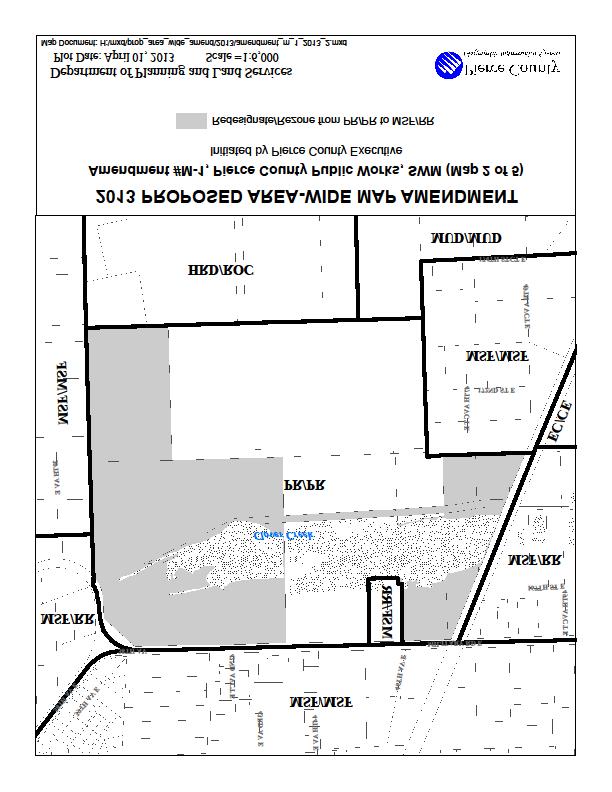
100
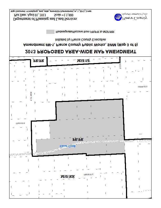
101
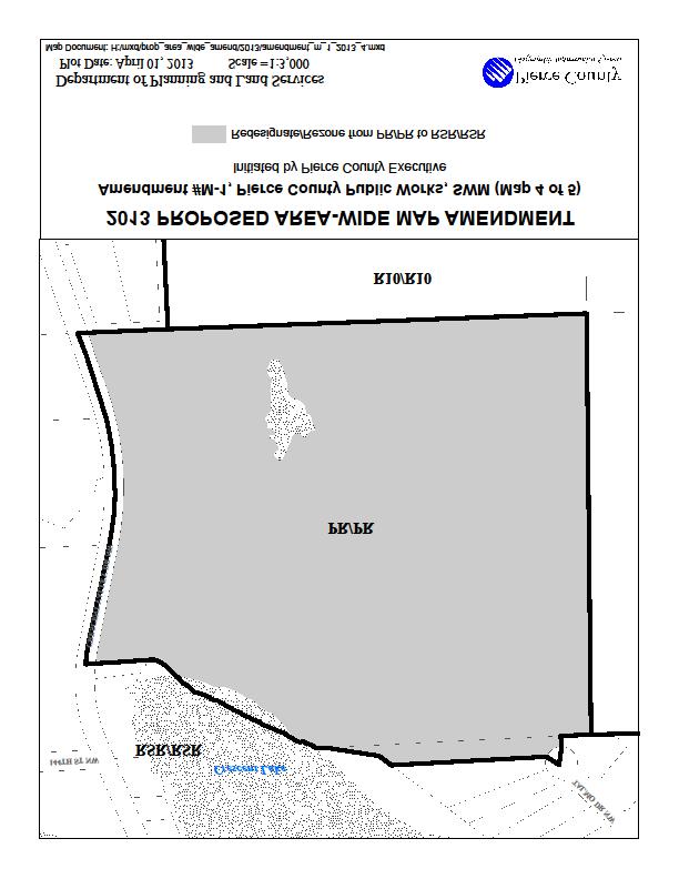
102
103

104
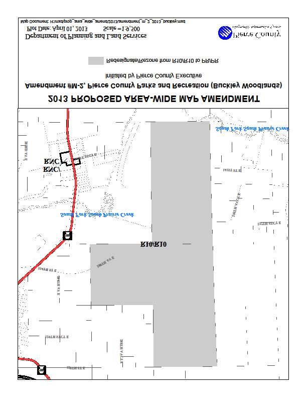
105
106
107
108
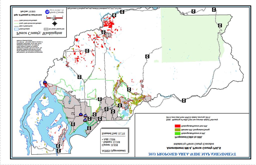
109
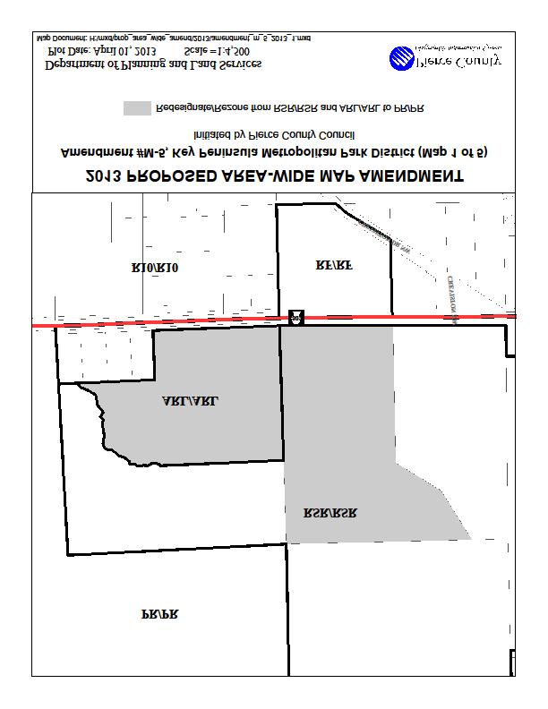
110
111
112
113
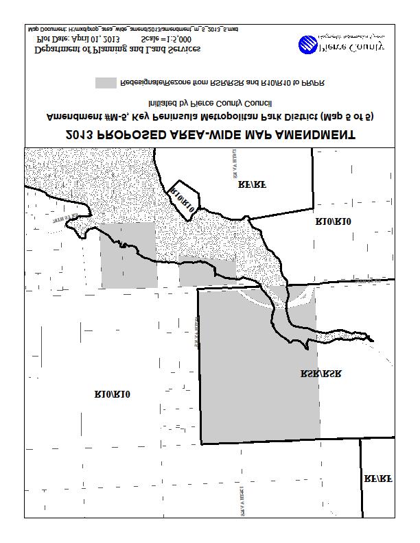
114
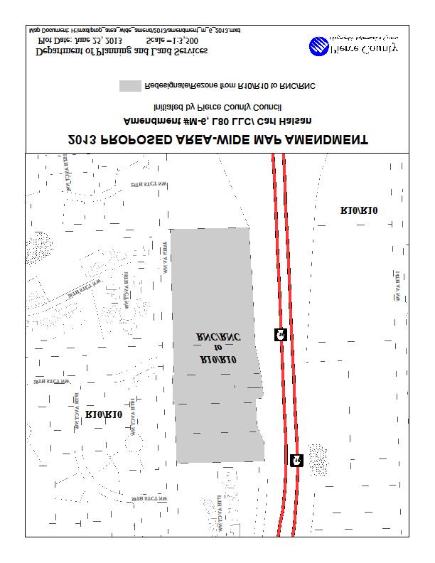
115
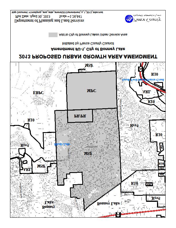
116
LU Encourage schools, institutions, and other community facilities that serve rural residents to locate in neighboring cities and towns.
 Application No. 891627: Comprehensive Plan Text Amendment - Rural School Policies - Amend policies consistent with State Legislation allowing schools in the rural area and extension of sewer service to
PSRC REVIEW REPORT & CERTIFICATION RECOMMENDATION
 PSRC REVIEW REPORT & CERTIFICATION RECOMMENDATION KITSAP COUNTY COUNTYWIDE PLANNING POLICIES July 2, 2012 BACKGROUND A major emphasis of the Washington State Growth Management Act (GMA) is the need to
CITY OF PUYALLUP. Background. Development Services
 CITY OF PUYALLUP Development Services 333 South Meridian Puyallup WA 98371 To: City Council From: Katie Baker, AICP, Planning Division Re: South Hill Neighborhood Plan Adoption Date: (Meeting date: February
Growth Area within the City of Gig Harbor s Potential Annexation Area in the East Bay area Pierce County Planning and Public Works
 Application No. 891681: Applicant: URBAN GROWTH AREA AMENDMENT Reduce the Urban Growth Area within the City of Gig Harbor s Potential Annexation Area in the East Bay area Pierce County Planning and Public
2016 Comprehensive Plan Amendments C OMPREHENSIVE P LAN T EXT AND M AP A MENDMENT
 2016 Comprehensive Plan Amendments T EXT A MENDMENTS D ISTILLERIES IN R URAL P OLICIES #844110 LID POLICIES #844112 M AP A MENDMENTS B ETHEL S CHOOL D ISTRICT #844237 P ARKS AND R ECREATION #844305 C OMPREHENSIVE
City of Richland Comprehensive Plan: Integrated Non-project Final Environmental Impact Statement
 City of Richland Comprehensive Plan: Integrated Non-project Final Environmental Impact Statement September 12, 2017 Prepared for: City of Richland Prepared by: Oneza & Associates With assistance from:
Rural Land Use Designations Kittitas County December 6, 2007 Draft
 KITTITAS COUNTY COMMUNITY DEVELOPMENT SERVICES 411 N. Ruby St., Suite 2, Ellensburg, WA 98926 CDS@CO.KITTITAS.WA.US Office (509) 962-7506 Fax (509) 962-7682 Rural Land Use Designations Kittitas County
Washington State Growth Management Act: The Basics. Kitsap County Department of Community Development
 Washington State Growth Management Act: The Basics Kitsap County Department of Community Development Purpose/History Enacted in 1990 Amended virtually every year since Manage Growth Concentrating population
6 PORT SYDNEY SETTLEMENT AREA
 Section 6 Port Sydney Page 61 6 PORT SYDNEY SETTLEMENT AREA 6.1 Basis and Principles Village of Port Sydney Waterfront Community Existing Services 6.1.1 Port Sydney is an historic settlement that has developed
3.10 LAND USE SETTING PROJECT SITE EXISTING LAND USE DESIGNATIONS AND ZONING. General Plan Land Use Designations.
 This section of the Draft EIR addresses the existing land uses on and adjacent to the project site and discusses the potential impacts of the proposed project on existing land uses. Key issues addressed
9 CITY OF VAUGHAN OFFICIAL PLAN AMENDMENT NO BOCA EAST INVESTMENTS LIMITED
 9 CITY OF VAUGHAN OFFICIAL PLAN AMENDMENT NO. 631 - BOCA EAST INVESTMENTS LIMITED The Planning and Economic Development Committee recommends the adoption of the recommendations contained in the following
EXECUTIVE SUMMARY DRAFT CHAPTER 1 INTRODUCTION EXECUTIVE SUMMARY
 CHAPTER 1 EXECUTIVE SUMMARY INTRODUCTION Through the joint efforts of the City of Tulsa planning staff and the Land Services division of Indian Nations Council of Governments (INCOG), the Berryhill Land
Staff Report and Recommendation
 Community Planning and Development Planning Services 201 W. Colfax Ave., Dept. 205 Denver, CO 80202 p: 720.865.2915 f: 720.865.3052 www.denvergov.org/cpd TO: City Council Neighborhoods and Planning Committee
RESOLUTION NO. R Refining the route, profile and stations for the Downtown Redmond Link Extension
 RESOLUTION NO. R2018-32 Refining the route, profile and stations for the Downtown Redmond Link Extension MEETING: DATE: TYPE OF ACTION: STAFF CONTACT: Capital Committee Board PROPOSED ACTION 09/13/2018
A. WHAT IS A GENERAL PLAN?
 I. Introduction A. WHAT IS A GENERAL PLAN? A general plan is the planning guideline for the future of a city. It contains goals and policies which regulate urban development, the protection of the natural
Ridgefield and the Growth Management Act
 1 2 Ridgefield and the Growth Management Act 3 Why Do We Plan History of Planning in Ridgefield Washington experiences rapid growth in the late 1980 s that began to change the perceived quality of life.
City of Tacoma Planning and Development Services
 Agenda Item D-3 City of Tacoma Planning and Development Services To: Planning Commission From: Stephen Atkinson, Associate Planner, Planning Services Division Subject: Land Use Designations - Phase 2 Meeting
LAND USE AMENDMENT CORNERSTONE (WARD 3) 60 STREET NE AND COUNTRY HILLS BOULEVARD NE MAP 26NE BYLAW 22D2017
 60 STREET NE AND COUNTRY HILLS BOULEVARD NE MAP 26NE BYLAW 22D2017") Page 1 of 14 EXECUTIVE SUMMARY This Land Use Amendment application covers an area of 43.76 hectares ± (108.14 acres ±) located in northeast Calgary, bound by Country Hills Boulevard NE to the south and
Page 1 of 14 EXECUTIVE SUMMARY This Land Use Amendment application covers an area of 43.76 hectares ± (108.14 acres ±) located in northeast Calgary, bound by Country Hills Boulevard NE to the south and
LAND USE ELEMENT. Purpose. General Goals & Policies
 LAND USE ELEMENT Purpose This Land Use Element contains the goals and policies necessary to support the City s responsibility for managing land resources and guiding development through implementing regulations,
Envision Skagit 2060 Citizen Committee Briefing Paper
 Envision Skagit 2060 Citizen Committee Briefing Paper Rural Villages & Fully Contained Communities (FCCs) By Mark Personius, AICP, Growth Management Consultant Rural Villages and Fully Contained Communities
Appendix G Response to Comments
 Appendix G Response to Comments This appendix contains the comments received during the public circulation and comment period (May 27, 2008 to July 11, 2008). The comments have been numbered (Comment Set
DOMINION BOULEVARD CORRIDOR STUDY AND ECONOMIC DEVELOPMENT STRATEGIC PLAN A MODEL FOR CHESAPEAKE S FUTURE
 DOMINION BOULEVARD CORRIDOR STUDY AND ECONOMIC DEVELOPMENT STRATEGIC PLAN A MODEL FOR CHESAPEAKE S FUTURE Overview I. Draft Plan Process II. Draft Plan Overview a. Market Analysis b. Master Land Use Plan
4.1 LAND USE AND HOUSING
 4.1 This section provides a project-level analysis of potential impacts to land use, Shorelines of the State (shorelines), and housing. The study area for the land use and housing analysis in the Final
REZONING GUIDE. Zone Map Amendment (Rezoning) - Application. Rezoning Application Page 1 of 3. Return completed form to
 - Application. Rezoning Application Page 1 of 3. Return completed form to") Zone Map Amendment (Rezoning) - Application COMMUNITY PLANNING & DEVELOPMENT REZONING GUIDE Rezoning Application Page 1 of 3 PROPERTY OWNER INFORMATION* CHECK IF POINT OF CONTACT FOR APPLICATION Property
Zone Map Amendment (Rezoning) - Application COMMUNITY PLANNING & DEVELOPMENT REZONING GUIDE Rezoning Application Page 1 of 3 PROPERTY OWNER INFORMATION* CHECK IF POINT OF CONTACT FOR APPLICATION Property
A Growing Community Rural Settlement Areas
 Town of Huntsville Official Plan Review - POLICY BACKGROUND PAPER A Growing Community Rural Settlement Areas BACKGROUND: In addition to the fully municipally-serviced Urban Settlement Area and the Hidden
Chapter 10 IMPLEMENTATION RECOMMENDATIONS
 Chapter 10 IMPLEMENTATION RECOMMENDATIONS The recommended land use plan presented in the previous chapter provides a design for the attainment of the urban and rural development and open space preservation
LEGAL NOTICE. City of Tacoma Determination of Environmental Nonsignificance. Fred Wagner, Wagner Development. Demolition of Manitou school buildings
 LEGAL NOTICE City of Tacoma Determination of Environmental Nonsignificance Lead Agency: Applicant: Proposal: Location: City of Tacoma Fred Wagner, Wagner Development Demolition of Manitou school buildings
178 Carruthers Properties Inc.
 178 Carruthers Properties Inc. Planning Rationale for 178 Carruthers Avenue Site Plan Control Application June 2014 Table of Contents 1.0 Introduction 2.0 Overview of Subject Property 3.0 Current Zoning
LAND USE DESIGNATIONS AND ZONING CLASSIFICATIONS
 LAND USE DESIGNATIONS AND ZONING CLASSIFICATIONS One of the most significant issues addressed within the community plan process is land use. How land is utilized within a community directly affects the
Glenborough at Easton Land Use Master Plan
 Implementation 114 9.0 IMPLEMENTATION 9.1 OVERVIEW This chapter summarizes the administrative procedures necessary to implement the proposed land use plan, infrastructure improvements, development standards,
D3 January 14, 2015 Public Hearing
 D3 January 14, 2015 Public Hearing APPLICANT: DONALD J. BOUCHER, JR. PROPERTY OWNER: D.J.B. SERVICE CENTER, LLC STAFF PLANNER: Kristine Gay REQUEST: A. Conditional Change of Zoning (I-1 to B-2) B. Conditional
VILLAGE OF CLEMMONS PLANNING BOARD DRAFT STAFF REPORT
 VILLAGE OF CLEMMONS PLANNING BOARD DRAFT STAFF REPORT PETITION INFORMATION Docket # C-226 Staff Megan Ledbetter Petitioner(s) JBJH Properties, LLC Owner(s) JBJH Properties, LLC Subject Property 5892-49-1766
Potential Annexation Areas And Annexation
 Exhibit A to Ordinance No. - Proposed Amendments to the Pierce County Countywide Planning Policies Addressing Potential Annexation Areas And Annexation 1 0 1 0 1 COUNTYWIDE PLANNING POLICY ON URBAN GROWTH
At first Work Session on October 22, At second Work Session on November 19, At third Work Session on December 3, 2015
 At first Work Session on October 22, 2015 Staff Reviewed Infrastructure: Transportation Capacity School Capacity Willett Branch Proposed Staging Language At second Work Session on November 19, 2015 Land
Urban Fringe Subarea Plan
 Urban Fringe Subarea Plan Updated February 27, 2018 Table of Contents Page I. Existing Goals and Policy Framework 2 A. Growth Management Act (GMA) B. County-wide Planning Policies C. Whatcom County Comprehensive
POLICY AMENDMENT AND LAND USE AMENDMENT KILLARNEY/GLENGARRY (WARD 8) NW CORNER OF RICHMOND ROAD AND 33 STREET SW BYLAWS 1P2015 AND 7D2015
 NW CORNER OF RICHMOND ROAD AND 33 STREET SW BYLAWS 1P2015 AND 7D2015") Page 1 of 13 EXECUTIVE SUMMARY This application seeks to redesignate an RC-2 (Residential Contextual One/Two Dwelling) parcel to MC-Gd72 (Multi-Residential Contextual Grade-Oriented) to allow for multi-residential
Page 1 of 13 EXECUTIVE SUMMARY This application seeks to redesignate an RC-2 (Residential Contextual One/Two Dwelling) parcel to MC-Gd72 (Multi-Residential Contextual Grade-Oriented) to allow for multi-residential
Infill Residential Design Guidelines
 Infill Residential Design Guidelines Adopted March 23, 2004 Amended September 10, 2013 City of Orange Community Development Department Planning Division Phone: (714) 744-7220 Fax: (714) 744-7222 www.cityoforange.org
12 January 12, 2011 Public Hearing APPLICANT: TAILWIND DEVELOPMENT GROUP,LLC PROPERTY OWNER: CITY OF VIRGINIA BEACH
 12 January 12, 2011 Public Hearing APPLICANT: TAILWIND DEVELOPMENT GROUP,LLC PROPERTY OWNER: CITY OF VIRGINIA BEACH STAFF PLANNER: Faith Christie REQUEST: Conditional Change of Zoning (from PD-H1 Planned
TOWN OF BRUDERHEIM Report to the capital region board
 TOWN OF BRUDERHEIM Report to the capital region board Introduction to the Town of Bruderheim Municipal Development Plan amendment and Relation to the CRB Evaluation Criteria 02 march 2017 1 Introduction
Planning & Zoning Commission Staff Report
 Planning & Zoning Commission Staff Report Meeting Date: May 26, 2015 Drafted by: Katherine Harrison-Rogers CASE # Z2886 PROJECT NAME: APPLICANT/ REPRESENTATIVE: Shawna Runyan PROPERTY OWNER: 1840 (previously
CONSENT CALENDAR CITY PLANNING COMMISSION AGENDA ITEM NO: A.1, A.2 STAFF: LARRY LARSEN
 Page 8 CONSENT CALENDAR CITY PLANNING COMMISSION AGENDA ITEM NO: A.1, A.2 STAFF: LARRY LARSEN FILE NO: CPC PUZ 14-00013 - QUASI-JUDICIAL FILE NO: CPC PUD 14-00014 QUASI-JUDICIAL PROJECT: APPLICANT: OWNER:
LAND USE OVERVIEW WHAT YOU WILL FIND IN THIS CHAPTER
 LAND USE WHAT YOU WILL FIND IN THIS CHAPTER Information about the City s expected population and employment growth. Description and capacity of existing and future land use designations. Policies that
Official Plan Review
 Official Plan Review Summary Report - The Built Environment August 2014 Part 1: Introduction Planning for a healthy, prosperous and sustainable community is an important goal for our municipality. From
COLVER ROAD INDUSTRIAL CONCEPT PLAN
 COLVER ROAD INDUSTRIAL CONCEPT PLAN A CONCEPTUAL LAND USE AND TRANSPORTATION PLAN FOR TA-4 AN URBAN RESERVE AREA OF THE CITY TALENT City of Talent Adopted by City Council Resolution No., June, 2015 PART
l D. The proposed amendments to the GPP are consistent with and advance the 2 Countywide Planning Policies (CPP), in particular:
, in particular:") 1 Approved: October 17, 2012 2 Effective: November 10, 2012 3 SNOHOMISH COUNTY COUNCIL 4 SNOHOMISH COUNTY, WASHINGTON 5 6 AMENDED ORDINANCE NO. 12-046 7 9 THE LAND USE 10 CHAPTER OF THE GENERAL POLICY
1 Approved: October 17, 2012 2 Effective: November 10, 2012 3 SNOHOMISH COUNTY COUNCIL 4 SNOHOMISH COUNTY, WASHINGTON 5 6 AMENDED ORDINANCE NO. 12-046 7 9 THE LAND USE 10 CHAPTER OF THE GENERAL POLICY
Chapter Master Planned Communities (MPC) District
 District") Sections 14.53.010 Purpose and Intent 14.53.020 Applicability 14.53.030 Procedure 14.53.040 MPC Standards 14.53.050 Required Findings 14.53.010 Purpose and Intent Chapter 14.53 Master Planned Communities
Sections 14.53.010 Purpose and Intent 14.53.020 Applicability 14.53.030 Procedure 14.53.040 MPC Standards 14.53.050 Required Findings 14.53.010 Purpose and Intent Chapter 14.53 Master Planned Communities
1INTRODUCTION. Purpose of the Truckee Railyard Master Plan
 1INTRODUCTION Purpose of the Truckee Railyard Master Plan The purpose of the Truckee Railyard Master Plan is to capture and describe the Town s vision for the Railyard Area and to guide its future redevelopment.
Woodburn Comprehensive Plan Growth Management Goals and Policies
 Goal Woodburn Comprehensive Plan Growth Management Goals and Policies G-1. The City's goal is to manage growth in a balanced, orderly and efficient manner, consistent with the City s coordinated population
NEW CASTLE COUNTY S ZONING DISTRICTS
 NEW CASTLE COUNTY S ZONING DISTRICTS This is general information about New Castle County s zoning districts. The information included is by no means exhaustive or complete. Before designing plans to develop
Section 4 BUILDING THE MASTER PLAN
 The Master Plan 33 Section 4 BUILDING THE MASTER PLAN Figure 4:1. A collaborative effort characterized the two design workshops sponsored by DISC to create hypothetical Master Plans for the Towers Property
PART 1: PROJECT SUMMARY. The application is Attachment A. The site plan is Attachment B.
 Belleterre Subdivision Sketch Plan Town Board 8.7.17 Belleterre Subdivision Sketch Plan PART 1: PROJECT SUMMARY Applicant: Bowman Development Project Size: +/- 20.85 acres Parcel Number: 01115104 and 01115121
Chapter 2: Land Use Element
 Chapter 2: Land Use Element CHAPTER 2: LAND USE ELEMENT A VISION FOR LAND USE As Lake Stevens continues to grow in population and area, the city will strive to create balanced opportunities for residential
Notice of Preparation and Notice of Public Scoping Meeting. At Dublin Project
 Notice of Preparation and Notice of Public Scoping Meeting Date January 17, 2018 To Project Title Project Application Number Project Location Project Applicant Contact For questions or submitting comments.
WATERFORD Plan of Preservation, Conservation and Development Supplement Part 1 - Policy Element
 WATERFORD 2012 Plan of Preservation, Conservation and Development 2015 Supplement Part 1 - Policy Element Effective June 11, 2015 2015 Plan Update GOAL To respond to the evolving land use needs and continually
Land Use Amendment in Southwood (Ward 11) at and Elbow Drive SW, LOC
 at and Elbow Drive SW, LOC") 2018 November 15 Page 1 of 10 EXECUTIVE SUMMARY This land use amendment application was submitted by Rick Balbi Architect on 2017 August 31 on behalf of Sable Developments Ltd, and with authorization from
2018 November 15 Page 1 of 10 EXECUTIVE SUMMARY This land use amendment application was submitted by Rick Balbi Architect on 2017 August 31 on behalf of Sable Developments Ltd, and with authorization from
ORDINANCE NO. City of Bellingham City Attorney 210 Lottie Street Bellingham, Washington INFILL HOUSING ORDINANCE Page 1
 ORDINANCE NO. AN ORDINANCE RELATING TO LAND USE PLANNING AND ZONING, CREATING A NEW BMC CHAPTER 20.28 INFILL HOUSING, AND NEW SUBSECTION BMC 20.12.030.E, GREEN FACTOR LANDSCAPING STANDARDS, AND AMENDING
COUNTY COUNCIL OF PRINCE GEORGE'S COUNTY, MARYLAND SITTING AS THE DISTRICT COUNCIL 2010 Legislative Session. Council Members Dernoga and Olson
 DR- COUNTY COUNCIL OF PRINCE GEORGE'S COUNTY, MARYLAND SITTING AS THE DISTRICT COUNCIL 00 Legislative Session Bill No. CB--00 Chapter No. Proposed and Presented by Introduced by Co-Sponsors The Chairman
Staff will be providing an overview of the project need, purpose and intent for consideration as part of the Amendment cycle.
 Agenda Item D-2 City of Tacoma Planning and Development Services To: Planning Commission From: Stephen Atkinson, Planning Services Division Subject: Open Space Corridors Project Meeting Date: March 1,
Growth Management Planning in the Central Puget Sound Region. Today s Presentation. Puget Sound Region. New Partners for Smart Growth
 Growth Management Planning in the Central Puget Sound Region New Partners for Smart Growth Denver, CO January 2006 Today s Presentation Regional growth management in central Puget Sound, WA Regional geographies
ESSENTIAL PUBLIC FACILITIES
 ESSENTIAL PUBLIC FACILITIES PURPOSE This section contains guidelines and policies which outline a process and define a set of criteria to be used to identify sites for development of facilities classified
City Center Specific Plan Amendments And Background Report City of Richmond. PLANNING COMMISION FINAL DRAFT January, 2001
 City Center Specific Plan Amendments And Background Report City of Richmond PLANNING COMMISION FINAL DRAFT January, 2001 TABLE OF CONTENTS Page LIST OF TABLES... LIST OF FIGURES... INDEX... OVERVIEW...
Edward R. Sajecki Commissioner of Planning and Building
 Corporate Report Clerk s Files Originator s Files CD.03.POR DATE: TO: FROM: SUBJECT: Chair and Members of Planning and Development Committee Meeting Date: February 27, 2012 Edward R. Sajecki Commissioner
E O L A F I V E. Location Map SUMMARY G M P Z O N I T E M S # 1 A. & B.
 N. Eola Drive Staff Report to the Municipal Planning Board August 18, 2015 G M P 2 0 1 5-0 0 0 1 9 Z O N 2 0 1 5-00016 I T E M S # 1 A. & B. A N X 2 0 1 2-0 0 0 0 5 G M P 2 0 1 2-0 0 0 0 6 Z O N 2 0 1
REQUEST FOR QUALIFICATIONS
 REQUEST FOR QUALIFICATIONS VILLAGE OF HAMBURG COMPREHENSIVE ZONING/LAND USE REGULATIONS UPDATE Prepared By: Village of Hamburg 100 Main Street Hamburg, New York 14075 Village of Hamburg RFQ Page 1 of 10
COMMISSION ACTION FORM
 ITEM #: 6 DATE: 09-06-17 COMMISSION ACTION FORM REQUEST: Introduction and Initial Review of Proposed Amendments to the Ames Urban Fringe Future Land Map for the North Growth Gap Area BACKGROUND INFORMATION:
ORDINANCE NO. WHEREAS, the Comprehensive Plan directs that master plans be developed for each proposed urban village (FLU-18), and
, and") ATTACHEMENT 1 ORDINANCE NO. AN ORDINANCE RELATED TO LAND USE PLANNING AND ZONING ESTABLISHING THE FOUNTAIN DISTRICT URBAN VILLAGE SUBAREA PLAN, AMENDING PORTIONS OF LAND USE AREAS 3 AND 8, AND ALL OF AREAS
ATTACHEMENT 1 ORDINANCE NO. AN ORDINANCE RELATED TO LAND USE PLANNING AND ZONING ESTABLISHING THE FOUNTAIN DISTRICT URBAN VILLAGE SUBAREA PLAN, AMENDING PORTIONS OF LAND USE AREAS 3 AND 8, AND ALL OF AREAS
AWH REPORT OF THE PLANNING AND DEVELOPMENT DEPARTMENT FOR APPLICATION FOR REZONING ORDINANCE TO PLANNED UNIT DEVELOPMENT
 AWH REPORT OF THE PLANNING AND DEVELOPMENT DEPARTMENT FOR APPLICATION FOR REZONING ORDINANCE TO PLANNED UNIT DEVELOPMENT MAY 8, 2014 The Planning and Development Department hereby forwards to the Planning
This chapter describes the purpose of the Plan, introduces how the Plan is organized and provides contextual background for the Plan.
 Chapter 1: INTRODUCTION Purpose of a Comprehensive Plan The 2040 Comprehensive Plan establishes Medina s vision as a community and sets goals and objectives which guide future decisions and policies. The
open public hearing and allow public comment request to continue LPA public hearing to January 16, 2014 at 10:30 am
 TODAY S AGENDA Work Session LPA Transmittal Public Hearing open public hearing and allow public comment request to continue LPA public hearing to January 16, 2014 at 10:30 am staff will issue a recommendation
4.1.3 LAND USE CATEGORIES
 4.1.3 LAND USE CATEGORIES a. City Center District The City Center District incorporates the existing character and mix of uses in downtown Belmont to encourage redevelopment and new development in keeping
Note: Staff reports can be accessed at Zone: I-3. Tier:
 The Maryland-National Capital Park and Planning Commission Prince George s County Planning Department Development Review Division 301-952-3530 Note: Staff reports can be accessed at www.mncppc.org/pgco/planning/plan.htm.
THE CORPORATION OF THE TOWN OF OAKVILLE BY-LAW NUMBER
 THE CORPORATION OF THE TOWN OF OAKVILLE BY-LAW NUMBER 20012-08530 A by-law to adopt an amendment to the Official Plan of the Oakville Planning Area (Official Plan Amendment 198) Land North of Dundas Street.
3.0 PROJECT DESCRIPTION
 3.0 PROJECT DESCRIPTION 3.1 BACKGROUND Under California law (Government Code Section 65300 et seq.), every city and county is required to have a general plan. The general plan is to be comprehensive and
Chapter 6: Community Character
 Chapter 6: Community Character The term "community character" covers a broad spectrum of concerns. First and foremost, community character is a visual concept. In Long Grove, however, community character
Planned Development Review Revisions (Project No. PLNPCM )
") Planned Development Review Revisions (Project No. PLNPCM2014-00139) Standard residential development Planned Development Example: Smaller lot sizes than what is allowed to create open space amenity. What
Planned Development Review Revisions (Project No. PLNPCM2014-00139) Standard residential development Planned Development Example: Smaller lot sizes than what is allowed to create open space amenity. What
DISCUSSION ON VACAVILLE S2 INVESTORS PROPERTY IN URBAN RESERVE
 Agenda Item No. 9C April 25, 2017 TO: FROM: SUBJECT: Honorable Mayor and City Council Attention: Jeremy Craig, Interim City Manager Barton Brierley, AICP, Community Development Director (Staff Contact:
SECTION UNIFIED DEVELOPMENT ORDINANCE SECTION Part 1 Ordinance. ARTICLE 1 Zoning Districts
 SECTION 1-100 UNIFIED DEVELOPMENT ORDINANCE SECTION 1-300 Part 1 Ordinance SECTION 1-100. Introduction. ARTICLE 1 Zoning Districts Crystal Lake strives to maintain a balance of various land uses for a
CHAIR AND MEMBERS PLANNING & ENVIRONMENT COMMITTEE JOHN M. FLEMING MANAGING DIRECTOR, PLANNING AND CITY PLANNER
 TO: FROM: SUBJECT: CHAIR AND MEMBERS PLANNING & ENVIRONMENT COMMITTEE JOHN M. FLEMING MANAGING DIRECTOR, PLANNING AND CITY PLANNER APPLICATION BY: THE CORPORATION OF THE CITY OF LONDON OUTDOOR PATIOS IN
SPECIFIC PLAN Requirements
 CITY OF LANCASTER PLANNING DEPARTMENT 44933 Fern Avenue, Lancaster, California 93534 (661) 723-6100 SPECIFIC PLAN Requirements Purpose The purpose of a specific plan is to provide for the logical development
CHAPTER 2 SUMMARY 1. PROJECT SUMMARY DATA
 CHAPTER 2 SUMMARY This is an Initial Study format used to determine, pursuant to CEQA Guidelines Section 15177, whether a project 1) is within the scope of a Master EIR (MEIR), 2) may result in additional
ONTARIO MUNICIPAL BOARD
 PL 120483 ONTARIO MUNICIPAL BOARD Applicant/Appellant: 2124123 Ontario Limited Subject: OPA, Rezoning and Draft Plan of Subdivision Municipal Address: 3940 Highway 7 East Municipality: City of Markham
Public Visioning City of Kelso Planning Commission
 Shoreline Master Program Update Public Visioning City of Kelso Planning Commission November 13, 2012 Schedule Jurisdiction Inventory Analysis Visioning Topics Process Governing Principles Structure of
5 TOWN OF MARKHAM OFFICIAL PLAN AMENDMENT NO. 144 MILLIKEN MAIN STREET SECONDARY PLAN
 5 TOWN OF MARKHAM OFFICIAL PLAN AMENDMENT NO. 144 MILLIKEN MAIN STREET SECONDARY PLAN The Planning and Economic Development Committee recommends the following: 1. The communication from Brendan O Callaghan,
General Location Annex, Rezone & Preliminary Plat Lansdowne Addition, Unit Three
 NEWFOUNDLAND I-5 Agricultural District Subject Site SUNDANCE ANDERSON Single Family Residential CHRISTY PUD Agricultural District Highway Business General Location Annex, Rezone & Preliminary Plat Lansdowne
Citizen Comment Staff Response Staff Recommended Revision Planning Committee
 Citizen Comment Staff Response Staff Recommended Revision Planning Committee Area No. 1: Owner desires retail land uses. Area No. 1a: Owner of two small parcels adjacent to Area No. 1 desires retail land
Chapter 1 - Land Use
 Chapter 1 - Land Use Discussion The Land Use Chapter plays the central role of guiding urban, rural and resource land use patterns and decisions for the unincorporated portions of Kitsap County. In keeping
I. INTRODUCTION. Project Background and Study Area
 I. INTRODUCTION Project Background and Study Area Freedom Parkway is a key east-west corridor connecting I-25 on the west to the Town of Kersey on the east, running approximately one to two miles south
Communities Plan. Parkland-Spanaway-Midland. LUAC Review of Draft Policies
 Parkland-Spanaway-Midland Communities Plan LUAC Review of Draft Policies Presented by: Tiffany O Dell, Senior Planner Planning & Public Works Tiffany.Odell@co.pierce.wa.us 253-798-6859 November 1, 2017
Dwelling Units Max 12 dwelling units per acre/min 8 dwelling units per acre. Development Mix 80% non residential/20% residential
 13. OSTEEN LOCAL PLAN Background: The Osteen Local Plan area is located in southwest Volusia County along the SR 415 corridor between Lemon Bluff Road and Acorn Lake Road and includes 3,990 acres. The
COUNTY-WIDE PLANNING POLICIES
 Thurston County COUNTY-WIDE PLANNING POLICIES November 10, 2015 These policies were adopted by the Board of County Commissioners on September 8, 1992. They were ratified earlier by each of the seven cities
Erik Rundell, Project Manager
 Erik Rundell, Project Manager M.U.R.P., Portland State University Certificate, Commercial Real Estate, University of Washington Graduate Certificate, GIS, University of Wisconsin-Madison B.A. Geography,
ROAD CLOSURE AND LAND USE AMENDMENT SILVER SPRINGS (WARD 1) NORTHEAST OF NOSEHILL DRIVE NW AND SILVER SPRINGS ROAD NW BYLAWS 2C2018 AND 29D2018
 NORTHEAST OF NOSEHILL DRIVE NW AND SILVER SPRINGS ROAD NW BYLAWS 2C2018 AND 29D2018") Page 1 of 19 EXECUTIVE SUMMARY This application proposes redesignating two parcels in the community of Silver Springs from Special Purpose Future Urban Development (S-FUD) District and undesignated road
Page 1 of 19 EXECUTIVE SUMMARY This application proposes redesignating two parcels in the community of Silver Springs from Special Purpose Future Urban Development (S-FUD) District and undesignated road
Rural issues need to be addressed in a comprehensive manner, with clear criteria for identification, development, and use of these lands
 VISION 2020 + 20 Update Issue Paper on Rural Areas Puget Sound Regional Council August 25, 2005 Growth Management Policy Board adopted Action to Proceed August 25, 2005 Urban Growth Area Rural Rural issues
Secrest Short Cut and Monroe Expressway Small Area Plan AUGUST 29, 2018
 Secrest Short Cut and Monroe Expressway Small Area Plan AUGUST 29, 2018 Background and Process Monroe Expressway will be open by the end of 2018 Union County and Indian Trail identified a need to revisit
ARLINGTON COUNTY, VIRGINIA
 ARLINGTON COUNTY, VIRGINIA County Board Agenda Item Meeting October 15, 2005 DATE: September 28, 2005 SUBJECT: Request to Advertise the adoption of the 2005 Clarendon Sector Plan C. M. RECOMMENDATION:
Concord Community Reuse Project Goals and Guiding Principles. Overarching Goals (OG)
") Concord Community Reuse Project Goals and Guiding Principles Overarching Goals (OG) No priority is implied by the order of presentation of the goals and guiding principles. Overarching goals for the Concord
Concord Community Reuse Project Goals and Guiding Principles Overarching Goals (OG) No priority is implied by the order of presentation of the goals and guiding principles. Overarching goals for the Concord
Chesapeake Bay Critical Area Conservation Plan
 The Maryland-National Capital Park and Planning Commission Prince George s County Planning Department Development Review Division 301-952-3530 Note: Staff reports can be accessed at www.mncppc.org/pgco/planning/plan.htm.
Sustainable Growth. Sustainable Growth
 2 Sustainable Growth Sustainable Growth SUSTAINABLE GROWTH 2.1 COMMUNITY VISION... 2-5 2.2 THE CITY SYSTEM... 2-7 2.2.1 AREAS... 2-7 2.2.2 CITY-WIDE SYSTEMS... 2-8 2.2.3 PROVINCIAL PLAN BOUNDARIES AND
SONOMA LOCAL AGENCY FORMATION COMMISSION
 For accessibility assistance with any of the following documents, please contact Sonoma LAFCO at (707) 565-2577 or email us at cynthia.olson@sonoma-county.org. SONOMA LOCAL AGENCY FORMATION COMMISSION
IMPLEMENTATION STRATEGIES. In This Chapter. Goals & Strategies 182 Project List 183 Future Land Use 186 CHAPTER 11 IMPLEMENTATION STRATEGIES
 In This Chapter Goals & Strategies 182 Project List 183 Future Land Use 186 11 IMPLEMENTATION STRATEGIES NORTH AUGUSTA, SC 2017 COMPREHENSIVE PLAN 179 Individual commitment to a group effort that is what