1. INTRODUCTION Policy context Aims of the DCP How does the DCP relate to other instruments and policies?...
|
|
|
- Tyrone Barber
- 5 years ago
- Views:
Transcription
1
2 CONTENTS 1. INTRODUCTION Policy context Aims of the DCP How does the DCP relate to other instruments and policies? DECISION MAKING PROCESS When is approval required? Other Approvals Matters to be considered Variations to Standards Community Involvement SITE PLANNING AND ENVIRONMENTAL CONSTRAINTS Environmental Constraints Tree Preservation Bushland Bio-diversity Bushfire Hazard Existing Screen Planting Natural Landscape Human Comfort Elements Heritage Items and Conservation Areas DESIGN ELEMENTS Streetscape Visual Character Public Domain and Communal Spaces Building Setbacks Battle-axe Blocks Front Fences Visually Prominent Sites Building Form Floor Space Ratio (FSR) Height of Building Relationships with Adjoining Dwellings First Floor Attic Rooms Roof Line Built-Upon Area Design Additions and Alterations New Dwellings Solar Access External Noise Sources Slope Cut and Fill External Finishes Corner Properties Construction for Bushfire Hazard Protection against Termites Air quality Building Materials Open Space and Landscape... 31
3 4.3.1 Landscape Requirements Tree and Landscape Bonds Soft Landscaping Area Landscape Character Tree Preservation Tree Replenishment Landscaping - Cut and Fill Useable Open Space Biodiversity Screen Planting Bushfire Hazard Weeds Privacy and Security Visual Privacy Acoustic privacy Safety and Security Access and Parking Number of car spaces Size of Car Spaces Design of Carports and Garages Location of Parking Structures Access Driveways Ancillary Facilities Swimming Pools/Spas & Enclosures Tennis Courts Out-buildings Other Site Facilities MANAGING CONSTRUCTION OR DEMOLITION Site management Measures to Minimise Site Disturbance Pollution Control Air Pollution Paint & Other Pollutants Resource Waste Management Measures to Save Resources and Minimise Waste Tree protection Tree Protection Measures Noise control Construction Hours Noise limits REFERENCES GLOSSARY... 54
4 APPENDIX A APPENDIX B APPENDIX C APPENDIX D APPENDIX E... 70
5 Schedule of Amendments AMENDMENT 1 The illustrated edition of has the same content as which came into operation on 4 February There have been minor changes to reflect name changes, grammatical corrections and to omit content rendered obsolete by legislative changes (ie. deletion of Appendix I Bushfire Hazard now superseded by the Planning NSW and Rural Fire Service document Planning for Bushfire Protection December 2001 ) 2 The amendments clarify the requirements for car parking and access and to ensure consistency with Council s other DCPs including water and waste management ADOPTED April 2006 Effective 28 April 2006
6 1. INTRODUCTION Policy context. Aims of the DCP. The role of the DCP with respect to other instruments and policies. How to use this DCP. 1.1 Policy context Harmony between built and natural features is a recurring theme of the public interest expressed about Ku-ring-gai s environment. There has been community concern with the large, dominating out of character building forms that resulted from the original and it has proved necessary to introduce tighter prescriptive controls to deal with this problem and seek to encourage development which is more compatible with Ku-ring-gai s unique residential character and environment. Ku-ring-gai, with its high rainfall, steep terrain and ridge tops, capped with rich shale soils, has evolved a special tall tree character, which most of its residents wish to retain. In recent years much of the tall tree canopy has been lost unnecessarily due to unsympathetic development and one of the purposes of this DCP is to ensure that a balanced emphasis is placed on landscaping to reverse this trend. New tree planting, together with existing trees, are to be integrated into new developments, so that the built form does not dominate the landscape and houses are set within a treed environment and retain a tree canopy background to the horizon. Council recognises that in allowing for redevelopment it has a responsibility to ensure that the visual and environmental quality and residential amenity of the Municipality is maintained and enhanced. To achieve this an integrated approach to site planning, design and policy implementation is required. This DCP: Establishes the fundamental roles of site analysis and statement of environmental effects in the overall design process to ensure proposals are designed and sited to reflect the site conditions and environmental constraints, while also respecting the neighbourhood character and amenity of adjoining properties. Contains assessment criteria made up of both prescriptive and performance standards to guide design. Focuses on outcomes in order to be responsive to the visual character and future vision for Ku-ring-gai, which is a heritage municipality within national parks. 1
.")


7 Ecologically Sustainable Development (ESD) Ecologically sustainable development is that which uses, conserves and enhances the community s resources so that ecological processes, on which life depends, are maintained and the total quality of life now and in the future can be increased. (Source: National Strategy for Ecologically Sustainable Development, 1992). ESD is essentially about creating a system which is self sustaining in the long term. There are three principles that can assist in achieving ESD: The precautionary principle: if there are threats of serious or irreversible damage, lack of full scientific certainty should not be used as a reason for postponing measures to prevent environmental degradation. Inter-generational equity: the present generation should ensure that the health, diversity and productivity of the environment is maintained or enhanced for the benefit of future generations; and The conservation of biological diversity and ecological integrity. Council is committed to the principles of ecologically sustainable development and these should be clearly demonstrated throughout all phases of the development process including: Identification of a suitable site Site analysis Site Planning Project design Development assessment Site preparation Construction, landscaping and treatment of surface and subterranean water flows Ongoing maintenance Ku-ring-gai Environmental Constraints 1. Ku-ring-gai s environmental constraints include: 2. Areas of high erosion potential (eg high rainfall, sensitive soils, steep terrain). 2
8 3. Extensive areas of native bushland and national parks (eg impacts of urban run-off, introduced weed species, bushfires). 4. The need for preservation and enhancement of tree cover (eg biodiversity, transpiration, amenity). 5. Bushfire hazard. 6. Numerous and fragile watercourses Sensitive sites (eg steep terrain, rocky outcrops and remnant bushland). Endangered ecological communities (eg Blue Gum High Forest). 1.2 Aims of the DCP The aims of this DCP are to: 1. Encourage development which does not dominate, but harmonises with and contributes to the treed landscape and is sympathetic to the street and locality in which it is proposed. 2. Ensure that with each development sufficient landscaping is provided to contribute to the conservation and replenishment of the tree canopy of Ku-ringgai, including locally occurring native tree species suited to the site. 3. Conserve and protect the natural, built and cultural heritage significance of Kuand fauna), the natural ring-gai, including heritage items and conservation areas, and encourage development which respects that significance. 4. Conserve and protect endangered species (flora topography, and other geographical and environmental features of Ku-ring-gai. 5. Achieve ecologically sustainable development. 6. Ensure appropriate provision is made for drainage in order to minimise impact on neighbours, watercourses, trees and other elements of the built and natural environment. 7. Protect and minimise the impact of development on adjoining properties and the natural environment. 8. Encourage housing of the highest possible architectural, environmental and amenity standards. 9. Manage residential development in a way that recognises the reasonable needs of innovative design and contemporary lifestyles. 10. Achieve without compromising the retention of significant trees, energy efficient design and where possible, solar access. 11. Clarify the requirements relating to development so that there are more certain outcomes for both the applicants and the community. 1.3 How does the DCP relate to other instruments and policies? This DCP complements the statutory requirements in Ku-ring-gai s deemed environmental planning instrument, known as the Ku-ring-gai Planning Scheme Ordinance 1971 (as amended) by providing detailed provisions to be considered when assessing applications for single lot detached residential development. It should be read in conjunction with all other relevant DCPs and Council policies referred to in Section 2.3 and other State Environmental Planning Policies and Regional Environmental Plans (such as SEPP19 Bushland in Urban Areas, SEPP55 Contaminated Lands etc.) The most up to date information concerning Council DCPs and policies is available on Council s website at 3
9 This DCP applies to all land within Ku-ring-gai on which a dwelling house may be erected, but relates only to a detached dwelling and associated development on a single lot. It has been prepared in accordance with the Environmental Planning and Assessment Act 1979 (as amended) and its Regulations. 2. DECISION MAKING PROCESS 2.1 When is approval required? The Environmental Planning and Assessment Act 1979 (as amended) provides Councils with the authority to require in certain cases, a development application to be lodged and determined prior to any development occurring. Reference should be made to DCP 46 Exempt and Complying Development to determine whether an application is indeed required. 2.2 Other Approvals In addition to development consent, the following activities may require separate approval from Council or other Authorities: Demolition (if not already included in your application); tree removal; placement of building materials; placement of waste container or trailer; hoardings; signs; and Integrated Development Applicants are advised to contact Council if the proposed development includes any of the above. 2.3 Matters to be considered The matters to be considered for all forms of development are becoming more complex and often involve a wide range of issues. Council must take into account the community s views with regard to proposed development and has a responsibility to balance competing interests for the benefit of the community. Where applicable the following will be considered: The aims and objectives of the Environmental Planning and Assessment Act 1979; Section 79C, Environmental Planning and Assessment Act, 1979; In the case of integrated development, the requirements of other legislation relevant to the application (see other legislation referred to in the glossary definition for Integrated Development); Relevant State Environmental Planning Policies and Regional Environmental Plans. Ku-ring-gai Planning Scheme Ordinance 1971: i. Aims and objectives of Schedule 9; ii. The development standards of the Ordinance; Council Development Control Plans, including but not limited to: DCP 40 Construction and Demolition Waste Management 4
10 DCP 43 Car Parking for Developments in Area DCP 47 Water Management Plan Council policies, codes and guidelines, including but not limited to: Council s Riparian Policy 2004 Visual Character Study (Refer to Appendix A) Landscape Management Policy 1996 Submissions received from the public and referral authorities. 2.4 Variations to Standards a. A variation to any development standard of the Ku-ring-gai Planning Scheme Ordinance (the planning instrument ) necessitates the submission of an SEPP 1 Objection signed by the applicant outlining why compliance with a particular development standard is unreasonable or unnecessary. eg. Buildings over a cliff line where it is not possible to have a stepped construction without a small section of the building exceeding 8 metres in height. b. Standards specified in this DCP may in some circumstances be considered inappropriate for various reasons. In such cases written reasons for a departure from the DCP standard should be submitted. eg. It might be submitted that the variation of a building line is warranted to permit retention of a tree behind a new dwelling. 2.5 Community Involvement Public participation and community consultation are an essential part of the planning and development process. To allow community involvement in the development process, has adopted a Notification Policy for development applications which provides details on: Who will be directly notified by mail of a development proposal; Applications which will not be notified; The form and content of notification. A copy of the Notification Policy is available from Council. Neighbouring residents, since they are most likely to be affected by a development, should be consulted early in the project as part of the design stage. Early consultation and discussion can lead to better acceptance of a proposal. Where neighbours have a concern they should lodge a submission with Council, particularly if the development is deficient with regard to any of the assessment criteria outlined in Chapter 4 (Site Planning and Environmental Constraints) and Chapter 5 (Design Elements). These assessment criteria include the effect of the proposed development on neighbour amenity (such as overshadowing, building bulk and privacy issues) and streetscape. For larger and more controversial developments where streetscape issues are significant, residents in the street and immediate locality may wish to lodge submissions. Those considering making a submission may first wish to discuss the matter with a Council Development Control Officer (DCO). All submissions made in response to a development proposal should state the name and address of the person making the submission. If the submission is an objection, 5
11 the grounds for objection must be clearly stated and reasons given. Council is obliged to consider all submissions received but must balance the reasonable rights of competing interests in reaching a determination. 6
12 3. SITE PLANNING AND ENVIRONMENTAL CONSTRAINTS 3.1 Environmental Constraints OBJECTIVES a) To conserve Ku-ring-gai s landscape and habitat and ensure that the natural environment is not dominated by the b) built form. c) To protect and conserve Ku-ring-gai s natural, built and cultural heritage. d) To discourage fragmentation of the established landscape character as a result of increased development pressures and to encourage development that reinforces Ku-ring-gai s distinctive treed canopy character. e) To respect the natural topography. f) To maintain bio-diversity within Ku-ring-gai g) by retaining remanent native vegetation and wildlife habitats. h) To protect and improve the endange red Blue Gum High Forest, Duffy s Forest and Sydney Turpentine Ironbark Forest ecological communities and threatened species under the Threatened Species Conservation Act i) To protect and improve the ecologic al environment within and along Ku-ringgai s watercourses. j) To design for the high rainfall and steep catchment areas of much of Ku-ring- of ecologically sustainable development gai in accordance with the principles (ESD). k) To manage stormwater drainage and l) run-off problems. m) To protect and enhance neighbourhood n) and visual character. 7
13 ASSESSMENT CRITERIA Tree Preservation The proposed development should be designed and located so as to retain and minimise disturbance to as many existing trees on the site as possible. Note: A Tree Preservation Order applies to the Local Government Area of Ku- the ring-barking, ring-gai. This prohibits cutting down, topping, lopping, removing, injuring or wilful destruction of any tree having a height greater than 5 metres or a branch spread exceeding 4 metres except with the written consent of Council or unless the tree is exempt from the Order. Contravention of the Order. Substantial penalties under Section 126 of the Environmental Planning and Assessment Act Bushland Bushland areas must be protected and preserved in recognition of their: Value as part of the natural heritage; Habitat value; Aesthetic value; and Value as a recreational, educational and scientific environmental resource. Council views Bushland in Urban Areas as an extremely important element of the character of Ku-ring-gai Bio-diversity To conserve biodiversity the proposed development should: protect and enhance remnant native vegetation and the wildlife, which relies upon it for food and shelter. Identify and consider threatened species, populations, ecological communities and their habitats. Recognise the potential and value of preserving local seed banks in the soil in-situ. This shall be achieved by: Positioning dwellings, driveways, pools, tennis courts and other structures outside the canopy spread of existing significant trees; Avoiding cut and fill beneath the canopy spread of existing trees; Avoiding adverse changes to the water table. When retaining trees the root system, canopy spread, size, age and condition (health) of the tree needs to be considered. Proposed works beneath the canopy spread of trees should be avoided. Council may require a Tree Protection Bond on significant trees. This shall be achieved by: minimising disturbance to bushland areas; preventing run-off from the proposed development to adjoining bushland, and weed management. NOTE: The provisions of State Environmental Planning Policy 19 (SEPP19), bushland in urban areas of the EPA Act as amended have certain requirements that both Council and A pplicants must have regard to in the development application. This shall be achieved by: creating a buffer zone between development and remnant habitat to conserve landscape and habitat; preserving local seed banks in the soil and avoid the introduction of foreign soils. NOTE: If threatened species, population, ecological community or associated habitat is likely to be affected by a development then an 8-part Test (under Section 5A of the NSW Environmental Planning and Assessment Act 1979) will be required to be completed by a Consultant (in accordance with Division 2, Part 6 of the NSW Threatened Species 8
14 ASSESSMENT CRITERIA Conservation Act 1995). Appendix E lists the threatened species known to exist in Ku-ring-gai at the time of publication. However, listed threatened species and communities change over time and this list should not be considered definitive Bushfire Hazard On sites prone to bushfire or located adjacent to bushland, dwellings shall be sited to minimise potential bushfire hazard. Soft landscaping must ensure that species to be planted act to minimise bushfire hazard. Development is to comply with the Planning NSW document Planning for Bushfire Protection December Existing Screen Planting Development proposals shall preserve existing screen planting except weed species Natural Landscape Development proposals shall not unreasonably intrude or otherwise impact upon the natural features in the landscape, particularly on ridge-tops, rock form ations, water courses, sloping sites, vegetation or bushland either located on-site or on adjoining property Human Comfort Elements Development proposals shall consider the human comfort elements such as scale, wind, noise, temperature, solar access and shade. This shall be achieved by locating the proposed dwelling to ensure an appropriate fuel reduced outer zone and fuel free inner zone. The size of these zones is determined by the level of bushfire hazard, slope, aspect, building construction and design. Plantings on such sites shall be predominantly native and indigenous. A dense shrub layer should be avoided. (Refer to the Planning NSW document entitled Planning for Bushfire Protection December 2001 ). This shall be achieved by: positioning dwellings, driveways, pools, tennis courts and other structures outside the canopy spread of existing screen planting, and avoiding cut and fill beneath the canopy spread of existing screen planting. This shall be achieved by: preserving existing natural features; designing to reflect the slope of the land. It is desirable to leave steeply sloping parts of the site in their natural state. Considering the height, colour and roof pitch of the proposal to ensure the proposal does not dominate the surrounding area. Council may require noise attenuation measures on sites adjoining busy roads or railway lines. 9
15 ASSESSMENT CRITERIA Heritage Items and Conservation Areas The proposal should conserve the natural, built and cultural heritage significance of the place. Applicants should be aware that as a result of various heritage studies, Council is identifying additional urban conservation areas. In submitting Development Applications for heritage items, sites located in the vicinity of heritage items, or sites located in conservation areas, the consideration or awareness of particular heritage documentation or statutory provisions may be necessary. These include:- Heritage Conservation in Ku-ringgai: Guidelines for Development () Statement of Heritage Impact: Guidelines to Applicants (Ku-ringgai Council). Visual Character (Appendix A of DCP 38). Heritage matters dealt with in the Ku-ring-gai Planning Scheme Ordinance including the following clauses: - 61D Development of Heritage Items. - 61E Development in the vicinity of heritage items. - 61F Heritage advertisements and notifications. - 61G Conservation areas (Note: at the time of preparation of DCP 38 one conservation area existed in Frances Street Lindfield and others were in preparation). - 61H Conservation incentives relating to heritage items. Schedule 7 Heritage Items. NSW Heritage Manual (Heritage Office and Department of Urban Affairs and Planning). Statement of Heritage Impact (Heritage Office and Department of Urban Affairs and Planning). National Trust s identified Ku-ringgai urban conservation areas. Development, such as alterations and additions or new fencing, should retain the heritage significance of heritage items and their settings and the heritage significance of conservation areas or heritage items on an adjoining property. Development should respect the principles contained in The Australia ICOMOS Charter for the conservation of places of cultural significance (the Burra Charter). In conservation areas characterised by single storey dwellings, second storey additions, should be contained within the existing roof line. Note: A development application will be required for all applications relating to or possibly impacting upon heritage items or where development is located within a Conservation Area. A Statement of Heritage Impact may be included as part of the statement of environmental effects with the application. For heritage items a Statement of Heritage Impact would be included as part of the Statement of Environmental Effects with the application. Heritage assessment impact statements where required must be carried out by Heritage Consultant recognised by the Heritage Council of NSW unless of a minor nature. Reference should be made to: Heritage in Ku-ring-gai: Guidelines for development; Statements of Heritage Impact (Heritage Office/DUAP publication) Note: Applicants should refer to Council s Heritage and Conservation guidelines and discuss their proposals prior to lodgement with Council s Heritage and Urban Environment Advisor. 10
16 ASSESSMENT CRITERIA Burra Charter. 11
17 4. DESIGN ELEMENTS The following design elements provide guidance on a wide range of matters and Council s requirements that need to be considered and provided for in the early stage of the design and development process. Each of the six design elements has three components: a set of objectives; assessment criteria; and design requirements and illustrations. The "objectives" specified for each design Council wishes to achieve. The "assessment criteria" represent a means of assessing whether the desired outcomes will be achieved. The assessment criteria contained in this DCP provide both prescriptive and performance based requirements. Council will consider how well each of these criteria (where relevant) have been addressed by the applicant or designer when determining an application under this plan. The design requirements have been included in certain areas, prescribing the minimum standards by which Council will evaluate the application. The design illustrations are to show possible ways of achieving the outcomes. While these solutions may satisfy the assessment criteria, other solutions can also be adopted. The aim is to enable designers to develop a variety of appropriate design responses. 4.1 Streetscape OBJECTIVES element represent the outcomes that a) To ensure that the development is sensitive to the landscape setting, environmental conditions and established character of the street and locality. b) To ensure that the appearance of new development is of a high visual quality, enhances the streetscape and complements good quality surrounding development. c) To conserve the natural, built and cultural sig nificance of streetscapes of heritage value. 12


18 ASSESSMENT CRITERIA Visual Character Development should conserve and enhance the vi sual character of the street with particular reference to the integrating of: Architectural themes; Building scale and setbacks; Landscape themes; and Fencing styles. The Visual Character Study (refer Appendix A) should be used to determine the components of visual character in a particular area. The prominent characteristics of the neighbourhood should then be identified and considered as part of the site analysis. It is important to ensure that the tree dominated streetscape and character of Ku-ring-gai is reinforced by the desig n, and that the appearance of the dwelling relates to this character in scale and layout. No te: Visual character or streetscape is created by many features including: lot sizes, fencing, kerbs, setbacks, spatial separation, access arrangements, street tree planting, tall tree canopy backdrop to the horizon, native vegetation and private gardens, as well the architecture of individual residences and buildings. A key element in maintaining visual character is the degree of visibility of on-site development when viewed from the street, public reserves and adjacent properties. Predominantly single storey, with medium roof pitch Trees in street Gabled roof forms, mostly single storey Trees in front yard Hedges or open front fencing Open front fences Garages set back from street alignment Uniform setback Mixture of flat and pitched roofs Low front fences Predominantly 2 storey development Trees in front yard No front fences Uniform building setback Landscaped footpath 13
19 ASSESSMENT CRITERIA Public Domain and Communal Spaces Development should provide a positive contribution to the public domain and all areas shared by the community Building Setbacks Development should be appropriately located on site to: maintain streetscape character; ensure the amenity of neighbouring properties is maintained or enhanced; allow for the provision of landscaping and provide room for additional tree plantings to grow to maturity; facilitate solar access; protect significant vegetation; facilitate efficient use of the site; and minimise bushfire hazard by preserving a "fuel free" zone (where development is adjacent to high bushfire hazard areas). This shall be achieved by ensuring that development: is of an appropriate scale retaining consistency with the surrounds when viewed from the street public domain or adjoining development and not exceeding two storeys; minimises overshadowing and; integrates built form and soft landscaping (gardens and trees) within the tree canopy that links the public and private domain throughout Ku-ring-gai. Building Line (Front Setback) In Urban Conserva tion Areas the predominant setback pattern of the existing stre etscape shall prevail. Development must be appropriately located on the site having regard to the existing setback of adjoining properties, the setback pattern of the street block within which the proposal is situated and Council s minimum and average setback requirements. Where the predominant setback pattern of the existing streetscape reflects setbacks which exceed the required minimum, the greater setback suggested by the street character will apply. The required minimum and average setbacks are set out in the following tables: For Two Storey: Street Minimum Average Low side 9 metres 11 metres High side 12 metres 14 metres For Single Storey: Street Location Low side High side Minimum 9 metres 12 metres 14
20 ASSESSMENT CRITERIA Where gradients averaged over the front setback exceed 20 degrees on the low side, reduced setbacks may be considered. Buildings must be setback so that at least 75% of the front elevation of the building is setback not less than the specified average setbacks and the balance of the building frontage (not more than 25%) may be located up to the minimum setback. Corner Sites The minimum and average setbacks to the secondary street frontage on corner sites are set out in the following table: Minimum Average Setback (m) At least 50% of the secondary front elevation of the building must be setback not less than the specified average setbacks and the balance of building secondary frontage ( not more than 50%) may be located up to the minimum setback. Setbacks to side and rear boundaries shall be in accordance with the minimum setbacks apply ing to dwellings which are not on corner lots as set out below. 15
21 ASSESSMENT CRITERIA Side setbacks should allow for significant landscaping between buildings, particularly for two storey structures to soften the visual appearance when viewed from the street and from the neighbouring property. Two storey houses would need to accommodate some shrubs to a height of 6m, while for single storey houses shrubs to 3m would be sufficient. Setbacks will need to be of sufficient width to accommodate a pathway and at least 600mm of landscaping width for single storey developments. A greater landscaping width of at least 1.1 metres is required for the 6 metre shrub heights of 2 storey development. Where sites are of greater widths (over 20 metres) larger side setbacks should be progressively provided Battle-axe Blocks In the normal subdivision pattern of Ku-ring-gai buildings are in alignment, with public open spaces addressing the street and private open spaces in the rear. On battle-axe blocks dwellings are often sited adjacent to neighbours rear yards and private open space. To ameliorate the potential conflict, additional side setbacks may be required. Dwellings on battle-axe blocks should be sited so as not to detract from the amenity of private open spaces and living areas on neighbouring properties Front Fences As noted in design element Visual Character, front fences or their absence, are a critical aspect in determining the appearance of a street. Therefore, front fences if present in the street, should be designed and located so as to: Maintain the streetscape character; Be consistent with the established pattern Side Setbacks The minimum ground floor distance to a side boundary will be: Site Width Single Storey Two Storey Setback Setback Less than 20m 1.5m 2.0m 20m or more 9% of site width 12% of site width First Floor The first floor of any dwelling shall be setback a minimum of 2.5 metres or 15% of the site width, whichever is the greater. Rear Setbacks For sites with depth greater than 48 metres the minimum rear setbacks shall be 12 metres. Where sites have a depth of less than 48 metres then the minimum rear setback shall be 25% of the average site depth. This should be achieved by: For rectangular blocks (excluding the access handle) setbacks from the long boundaries will be a minimum distance to a side boundary of 15% of the site width or 3 metres, whichever is the greater. Setbacks from the remaining specified boundaries will be as given under rear setbacks for standard allotments. For irregular blocks or particularly narrow blocks, or in special cases,(eg the dwelling is single storey) Council may vary these figures, provided it can be shown the assessment criteria and objectives have been met. This should be achieved by: restricting visually solid forms (such as masonry, lapped and capped timber brushwood) to 900mm in height; restricting the height of visually transparent fences (such as metal grille or timber picket) to 1.2 metres. High solid fences in excess of 1.2 metres will 16
22 ASSESSMENT CRITERIA of fences; Allow private gardens to merge with their neighbours and support the landscape character of the area; Ensure an adequate amount of useable private open space; and Be historically appropriate and retain the heritage significance of heritage items and their settings and the heritage significance of conservation areas. Side and rear fences In many areas of Ku-ring-gai side fences forward of the front building line are unobtrusive and allow for continuity of landscape vista between adjoining properties. Where this character predominates it must be respected in new developments. Side fences on corner allotments should be designed and located so as to: maintain the streetscape character; be consistent with the established pattern of fences; ensure an adequate amount of usable private open space; and retain the heritage significance of heritage items and their settings, and the heritage significance of conservation areas. only be permitted in areas where they are compatible with the streetscape and the visual character statement. All such fences shall be set back at least 1.0 metre with provision of low maintenance screen planting in the setback area. Note: Refer to the Visual Character Study to determine the typical treatment of fences in the relevant character category. Note: Refer also to design element 4.4 Front fencing is not encouraged in areas where it does not form part of the overall streetscape. In such areas, the front boundary can be defined by low hob walls, by garden beds or planting. Side fences forward of the front building line should be compatible with the established front fencing in the street. Note: Refer to design element 4.4 and the provisions of the Dividing Fences Act No te: Side (between the building line and the rear boundary) and rear boundary fences with a maximum height of 1.8 metres are permissible without approval provided they satisfy the requirements of Council s DCP 46 Exempt and Complying Development. Hedges Hedges near boundaries must not create an amenity loss to adjoining properties by either blocking significant district, bushland or water views of neighbouring properties or unreasonably shading neighbours private open space or living areas in winter. Fences adjoining bushland Fences adjoining bushland should protect the bushland from domestic animals and blend harmoniously with This should be achieved by ensuring appropriate species planted near boundaries do not grow to excessive height and can be readily maintained at a height below 2 metres unless taller hedges are a feature of the locality and there are no adverse impacts on solar access or views. 17
23 ASSESSMENT CRITERIA the bushland setting Visually Prominent Sites Development on visually prominent sites should recognise the unique responsibility to ensure that the visual, scenic and environmental qualities of the locality are maintained. Visually prominent sites from the definition in this document includes ridge top locations, escarpments, environmentally sensitive sites on slo ping land, elevated corner allotments and any s ite that has the potential to dominate and degrade visual amenity. This should be achieved by: carefully integrating development into the existing landscape through the site planning process and avoiding tall and bulky structures; choosing external colours and finishes that are sensitive to the site and locality; retaining significant landscape and vegetation elements; considering views to the site as well as those from the site; and softening visual impact by extensive landscaping including larger trees and shrubs. Colours of materials used in sites adjoining or in close proximity to bushland areas and conservation areas must be in harmony with the built and natural landscape elements of the area. 4.2 Building Form OBJECTIVES a. To ensure that the bulk, scale and height of the proposed works do not dominate the natural landscape, existing streetscape, nor adversely impact on the tree canopy vista. b. To ensure that building bulk, height, location and footprint provide for sufficient soft landscape area for planting and retention of large canopy trees. c. To allow adequate daylight, sunlight and ventilation to living areas and private open spaces of new and neighbouring dwellings. d. To protect reasonable neighbour amenity including visual and acoustic privacy particularly in regard to living areas and private open space. e. To encourage the sharing of views, whilst not restricting the reasonable development potential of a site. f. To encourage well designed, attractive and site responsive buildings. g. To achieve consistency with the principles of ecologically sustainable development. ASSESSMENT CRITERIA Floor Space Ratio (FSR) Floor Space Ratio is the total floor space area The floor space ratio includes any garage of the building exp ressed as a ratio to the site area in excess of 31 square metres and area. In this Development Control Plan floor all storage areas. space is taken as the area of each floor within The floor space ratio also includes any the outer face of the external enclosing walls, terraces, balcony, decks, porches, open including voids. Some floor space credits are verandahs or the like above ground floor 18
24 ASSESSMENT CRITERIA available for a limited area of garage space and ancillary structures. The FSR control relates to dwellings in excess of one storey in height and has the intention to: Ensure the scale of such new development is not excessive and relates well to the local context and streetscape; Limit the bulk of such new dwellings so that they do not dominate the treed landscape of Ku-ring-gai and there is sufficient space on the site for the provision of an adequate number of medium to large trees; To minimise the impact of such development on significant views from and solar access to adjoining residential properties. level. Note: Council will allow a floor space credit of up to 15 square metres for these above ground level features where they make a positive contribution to the design. The maximum FSR will be in accordance with the table at the end of this section. For irregularly shaped or long narrow blocks where length to width ratio exceeds 4, or corner lots, Council may reduce the applicable FSR. The maximum FSR permissible is subject to site constraints and the design objectives of this DCP and so may not be achievable in all situations. Table of FSR for a Single Dwelling Site Area (m2) Maximum Permissible Gross Floor Space Ratio Range Floor Area (m2) Up to x (site area) 0.4: (0.25 x site area) 0.4:1 0.37: (0.20 x site area) 0.37:1 0.30:1 Over x (site area) 0.30:1 Note: The FSR s permissible in this table are subject to the site constraints 19

25 ASSESSMENT CRITERIA Height of Building A dwelling must not exceed two storeys in height. Council may consider an additional floor on sloping sites where the height is not evident from public areas or adjoining properties and excavation is not excessive. The intention of this standard is to: Limit the height of dwellings so that they do not dominate the treed landscape of Ku-ring-gai; Limit the extent of overshadowing and visual and aural intrusion on the private space of neighbouring properties; Ensure significant views from neighbouring dwellings are not unduly compromised; Maintain the integrity of existing streetscapes. The maximum height of a dwelling shall be: 2 storeys in height (including any garage, basement or the like) 8 metres for sites where the slope, averaged over the ground level change along the building foundation from front to rear or from side to side, is more than 20 degrees or; 7 metres for slopes less than 20 degrees. The following matters must be considered with regard to the potential impact on neighbouring properties: opportunities to minimise overshadowing and overlooking of living and private open space areas; opportunities to minimise adverse impacts on any significant bushland or water views; relationship with the streetscape. 20
26 ASSESSMENT CRITERIA 21
27 ASSESSMENT CRITERIA Relationships with Adjoining Dwellings Development should avoid the creation of an overbearing effect upon adjoining development in order to: Maintain the relative scale relationship between buildings; Ensure that daylight to habitable rooms in adjacent dwellings is not significantly reduced; Ensure that sunlight to the private open spaces of the subject property and adjacent properties is not significantly reduced; Encourage increased setback with increased height First Floor The first floor of dwellings should be well integrated into the design of the development to avoid overbearing bulk/scale relatio nship with neighbouring properties. This is particularly important on sloping sites. This may be achieved by: Ensuring appropriate side setbacks and landscaping are incorporated in the design. Compliance with the building height plane (as illustrated). This should be achieved by: "stepped back" upper levels in order to avoid bulky vertical wall surfaces; or by erecting the first floor within the existing/proposed roof space. First floor area must not exceed 40% of total floor space as defined in

28 ASSESSMENT CRITERIA Attic Rooms Use of attic rooms within the roof space for habitable purposes are encouraged in lieu of a second storey, particularly in neighbourhoods that are predominantly single storey dwellings. Attic rooms should not: increase the bulk of the building; cause undue overshadowing of adjacent properties and open spaces; cause loss of significant views from adjacent properties; or be excessive in scale and bulk relative to the rest of the building. The form and placement of any windows must respect the privacy of neighbouring properties. The resultant floor space will be used in calculating the total floor space Roof Line The roof of the building should be designed so that: it does not unduly increase the bulk of the building. in areas of heritage value it reinforces the existing streetscape character and the elements that contribute to this character. it does not cause undue overshadowing of adjacent properties and open spaces. (Refer to Solar Access) This should be achieved by: the careful selection of materials, colour and pitch; use of low-angled pitched roofs providing that they are compatible with existing development and the existing streetscape character; or inclusion of habitable rooms within the roof space. For single storey development or where the first floor is fully contained in the roof space the maximum roof height shall be 5 metres and for all other dwellings the maximum roof height will be 3 metres. The maximum roof pitch permitted is 35 : roofs with a steeper pitch than 35 shall 23
29 ASSESSMENT CRITERIA be considered as external walls. Unless otherwise consistent with the form of development within the immediate locality, gables and dormers should: be positioned a minimum of 200mm below the main roof ridge height; not occupy any more than 40% of the face of any gable wall and not occupy more than 20% of the face of any roof or slope for a dormer or gable window; not extend beyond the external wall of the dwelling Built-Upon Area Development should maintain a reasonable proportion of the site as soft landscaping to ensure that predominant landscape character of the locality is maintained or enhanced. Requirements for soft landscaping are specified in Section The built upon area should be reduced where stormwater cannot be directed to the street or a drainage easement. The maximum permissible Built-Upon Area (BUA) shall comply with the table set out at the end of this section. Where stormwater cannot be discharged to Councils drainage system and is disposed of on site, a reduced built upon area applies. Note: Built upon area means the area of a site containing any built structure (whether covered or uncovered), any building, carport, terrace, 24
30 ASSESSMENT CRITERIA pergola, hard-surface recreation area, swimming pool, tennis court, driveway, parking area, or any like structure but excluding minor landscape features. Council will not approve an application where reasonable provision has not been made for built elements such as pathways normally associated with a residential property. Council will also include elevated pathways as structures and built upon areas. Maximum Built Upon Area % Site Area m2 Single Storey 2 Storey Less than Greater than Design New development should incorporate architectural relief and modulation of facades to avoid a bulky appearance. This must be achieved by the following: No unrelieved walls in excess of 12 metres; Where walls exceed 4 metres in height, no unrelieved walls in excess of 8 metres are permitted; Substantial articulation of wall recesses; The use of articulated walls to provide enough space for tall shrub plantings; Incorporating variations in elevations to provide visual interest to buildings; The use of horizontal elements such as verandahs, pergolas or suitable planting schemes; 25
31 ASSESSMENT CRITERIA Integrating soft landscaping and natural site features with building design Additions and Alterations There should be architectural unity (in the design of alterations/additions) with existing dwellings. This should be achieved by matching external finishes of building work to the existing. Where appropriate, roof pitches should be extended and/or replicated. For major additions applicants should consider utilising the services of an architect so as to optimise the design outcome. 26
32 ASSESSMENT CRITERIA New Dwellings Architectural design must be compatible with the neighbourhood character where a defined character is evident and respect the streetscape and natural features of the site. Note: In the case of conservation areas see also Section Solar Access The design and siting of new development will: Maintain a reasonable level of solar access to habitable rooms, solar collectors and open space of adjoining development; Minimise overshadowing of public reserve and bushland; Provide a reasonable level of solar access to habitable areas and recreational open space by considering building siting and orientation; Control the desired amount of solar access to habitable rooms and recreational open spaces with the placement of windows and; Provide sun protection with the use of sun shading devices and by the placement of appropriate canopy trees. Dwelling design should be in accordance with the principles and standards of good design as detailed in this Development Control Plan. Applicants are encouraged to use the services of an architect to optimise design outcomes. This should be achieved by: Careful siting and orientation of buildings; Use of setbacks which increase with building heights; The careful placement of deciduous or tall high canopy trees. A building should be designed and sited to maintain solar access to adjoining properties of at least 4 hours between 9am and 3pm on 22 June to north facing windows and all living areas (family rooms, rumpus, lounge and kitchen) and the principal open space recreational areas such as swimming pools and patios. Dwelling design and orientation should also provide a similar level of solar access as detailed above, to the proposed dwelling. Where shadows cast by existing trees and buildings preclude satisfying the above requirements, sunlight during winter solstice should not be reduced by more than 20%. Professionally prepared Shadow Diagrams must accompany all applications for new dwell ings exceeding one storey. The shadow diagrams must include: True north; Levels to Australian Height Datum (AHD) at the corners of the buildings; Ridge and ground levels; Location of adjacent buildings affected by shadow and principal open space areas; The shadow cast by existing and proposed development at 9am, noon and 3pm on 22 June; and Where overshadowing is critical, elevation shadow diagrams may be 27
33 ASSESSMENT CRITERIA External Noise Sources Development should be designed so as to minimise the impact of external noise sources (eg busy roads, neighbour s swimming pool) on both internal and external space likely to be used by occupants. When designing and siting active living areas (eg. bbq areas, swimming pools, games rooms etc) regard to potential noise impacts on sensitive areas (eg bedrooms) of adjoining properties should be considered Slope The building form must have regard to the slope of the land to ensure appropriate proportions and height in relation to adjoining land. An appropriate form of construction (eg piers) which minimises disturbance of land to steep slopes should be used. Preference should be given to light-weight construction on such slopes. Excessive cut and fill should be avoided Cut and Fill The extent of excavation (cut) and fill must be minimised so as not to impact on existing trees required by Council to be retained, or significantly alter the natural landscape or watertable. required. This should be achieved by: The careful siting, orientation and design of a dwelling; Set back 14 metres to main and arterial roads unless the design incorporates noise attenuation measures addressed by an acoustic report to demonstrate internal compliance with 40dba. Compliance with Environmental Protection Authority/Roads and Traffic Authority/State Rail Authority noise standards where a site fronts a busy road or railway. This must be achieved by: Considering the slope of the land and adjoining development as part of the site analysis; Ensuring designs have regard for the site conditions; Incorporating the slope into the design, for example through split levels. Note: Sites with a slope in excess of 15% may require certification from a geotechnical engineer as to the stability of the slope and the suitability of the proposed design for that slope. This must be achieved by: accommodating the development within the natural slope of the land; accommodating the development outside the canopy spread of existing trees, where possible. Council may consider suspended floor systems where it is not possible to accommodate the development totally outside the canopy spread of existing trees; not exceeding 900mm in cut and fill relative to natural ground level, with a maximum level difference of cut and fill across the building area of 1,800mm and 900mm at any one point relative to natural ground level; avoiding cut or fill within minimum side setbacks from boundary lines as specified in
34 ASSESSMENT CRITERIA Note: If cut or fill is proposed, the site analysis (existing development) and site analysis (proposed development) must justify by means of documentation the reasons for the preferred option. Depending on the species and size of the tree, excavation may destabilise the tree. Fill over the root zone is undesirable because it prevents the movement of moisture and oxygen to the roots, which will have a detrimental effect on the tree. Development, such as driveways, is to be positioned so as to minimise works within the canopy spread of existing trees. Where possible stockpile mulch and topsoil, derived from excavation works on-site for later reuse in landscaping External Finishes The colour and surface finish of external building materials should minimise the overall visual impact of new development and be sympathetic to the surrounding locality and blend with the natural environment. Colours on sites adjoining or in close proximity to bushland areas and conservation areas must be in harmony with the built and natural landscape elements of the area. This must be achieved by the use of low reflective finishes, especially on ridgetop and escarpment locations and other visually prominent locations. Designs are not to contain large surfaces of predominantly primary colours and white where these would dominate the streetscape or other vista. in sites adjoining or in close proximity to bushland areas colours and colour tones should be in keeping with the natural earth tones. Note: Plans submitted to Council should be annotated with the proposed colour scheme. Reference to colours should be made in accordance with Australian Standard Colour standards for general purposes to ensure consistency Corner Properties The design of dwellings on a corner property must present an attractive façade to each frontage and address the corner. These properties are generally visually prominent and proposed development must have regard for the prominence of the particular site. This should be achieved by wrap-around house design, landscaping elements, feature windows, or other treatments to wall surfaces and staggered height of buildings. Refer also to Sections and Extensive blank or unarticulated walls to street frontages will not be accepted. 29
35 ASSESSMENT CRITERIA Construction for Bushfire Hazard On sites prone to bushfire hazard or where located adjacent to bushland, dwelling house design must adopt measures to minimise potential hazard. This may be achieved through a combination of locational and design factors as detailed below: A number of specific techniques can be incorporated into a dwelling to limit the hot products of combustion such as burning debris entering buildings, for example: fixed windows screened with external non-corrosive metal wire screens or fitted with toughened, laminated or safety glass; opening windows and doors screened with external non-corrosive metal wire screens; subfloor areas enclosed and sealed with subfloor ventilators fitted with noncorrosive screens; chimneys fitted with a non-corrosive metal screen having a maximum crosssectional mesh area of 0.25mm2; eaves enclosed with the fascia sealed; non-combustible roof cladding such as metal sheet or tile; use of only fire resistant materials in skylights; fully sarked roof with an approved flame retardant material; leaf proof guttering or designs without gutters. Council may require inclusion of water tanks and associated sprinkler systems and pumps in areas of high risk. Refer to: Australian Standard AS 3959 Construction of buildings in bushfire prone areas; and Building in bushfire prone areas, by G Ramsay (CSIRO) and D Dawkins (Standards Australia) Protection against Termites Structures must be designed with physical, This must be achieved by: rather than chemical, termite control measures. Appropriate materials and construction design; physical barriers; 30
36 ASSESSMENT CRITERIA suspended floor systems. Note: Council requires whole of structure protection. Chemicals which are harmful to the environment are not permitted Air quality The proposal should provide a positive contribution towards the improvement of global, regional and local air quality. Avoid the need for fuel burning heating and reducing energy consumption by using low energy cost materials. This should be achieved by adopting passive energy principles in site layout and building design, in order to: minimise the use of artificial lighting, heating and cooling; avoid the use of inefficient open fires; and locating flues and chimneys so as to avoid smoke and odour nuisance to adjoining properties. Note: Any solid fuel heating appliance must comply with the requirements of the Clean Air (Domestic Solid Fuel Heaters) Regulation Building Materials Consideration should be given to the life-cycle of products used (that is, the cradleto-grave impacts across the design life of structures). Design should include Ecologically Sustainable Principles. Council encourages the use of raw materials which will have a minimal impact on the natural environment during their growth, extraction, use and disposal. For example: avoid treated timbers for internal use; use plantation rather than old growth timbers. 4.3 Open Space and Landscape OBJECTIVES a. To maintain or enhance the predominant tree dominated landscape quality of Ku-ring-gai by retaining and replanting trees. b. To replenish the tree canopy of Ku-ring-gai c. To enhance the viability of bio-diversity within Ku-ring-gai by having a proportion of planting in new development that provides biolinkages between bushland reserves and by retaining remnant vegetation and wildlife habitats. d. To provide quality private and public open space areas for the amenity and enjoyment a. of residents. e. To retain and enhance significant shrubs and ground covers. f. To encourage replanting of locally occurring native plant species from locally collected seed. g. To protect and improve the ecological environment within and along Ku-ring-gai s watercourses. 31
37 h. To achieve consistency with the principles of ecologically sustainable development eg dealing with the high rainfall and steep catchment areas of much of Ku-ring-gai. i. To facilitate the transpiration of groundwater to the atmosphere by planting suitable canopy trees. j. To achieve effective management of stormwater drainage and run-off Landscape Requirements As mentioned in Section 2J of Council s DA Guide, plans for landscape, drainage and building design are the three outcomes derived from the site analysis. Due to mutual influences, these plans must evolve in parallel and potential conflicts must be resolved. It is important to recognise that depending on the area, landscape requirements may preclude certain building designs. Also, in certain heritage precincts particular garden forms may play an important role in defining the local streetscape. The end product of this parallel process will be complementary building and landscape plans which will provide for good living amenity, enhance the visual landscape character of Ku-ring-gai and the local streetscape and contribute to the sustainability of the significant bio- of the diversity region. When is a LANDSCAPE CONCEPT PLAN required? A Landscape Concept Plan prepared by a professionally qualified and experienced Landscape Architect or Landscape Designer, will be required to be submitted for all new dwellings, substantial additions and alterations, pools, tennis courts, and other larger structures or where a garden of heritage or landscape value is compromised. A landscape concept plan describes the design intent of a landscape proposal and indicates how landscape impacts of a development are to be addressed. Refer to Section 4E of Council s DA Guide for details. When is a LANDSCAPE PLAN and SPECIFICATION required? A detailed Landscape Plan and Specification (landscape construction notes) prepared by a professionally qualified and experienced Landscape Architect or Landscape Designer, will be required to be submitted to Council prior to issue of the Construction Certificate for all new dwellings, substantial alterations, additions and structures or where a garden of heritage or landscape value is compromised. The Landscape Plan and Specification (construction notes) must be of sufficient detail and content to be issued for construction purposes. The landscape design must be consistent with the Landscape Concept Plan submitted with the Development Application and approved by Council. Refer to Appendix B for Guidelines in preparing Landscape Documentation and for a typical example of a Landscape Plan. When is a SCREEN PLANTING PLAN and SPECIFICATION required? A detailed Screen Planting Plan and Specification (landscape construction notes) prepared by a professionally qualified and experienced Landscape Architect or Landscape Designer, will generally be required to be submitted to Council for alterations and additions, pools, tennis courts and other structures. Refer to Appendix B for Guidelines in preparing Landscape Documentation. When is a TREE PLANTING PLAN required? A Tree Planting Plan and Specification prepared by a professionally qualified and experienced Landscape Architect, Landscape Designer, Arborist or Horticulturalist may be required to be submitted to Council where canopy trees are required to be planted. Refer to Appendix B for Guidelines in preparing Landscape Documentation. 32
38 When is an ARBORIST REPORT required? An Arborist Report prepared by a qualified and experienced Arborist will be required to be submitted to Council where the site has significant trees or remnant bushland or as specified by Council. Refer to Section 2C of Cou ncil s DA Guide for further details. Who can implement the approved LANDSCAPE WORKS? Where major lands cape works are propo sed, eg for a new dwelling, they should be undertaken by qualified and experienced Landscape Contractors who are eli gible for membership of the NSW Landscape Contractors Association. The works are to be implemented in accordance with the Council approved landscape documentation Tree and Landscape Bonds Tree Protection Bond A Tree Protection Bond may be required to ensure significant trees are maintained in the same condition as found prior to commencement of site development work. The bond is refundable after the completion of tree and landscape work. Landscape Establishment Bond (New Dwellings) A Landscape Establishment Bond may be required to ensure that the landscaping is installed and maintained in accordance with the approved Landscape Plan, Screen Planting Plan or other landscape conditions. The bond is refundable after the completion of landscaping. Landscape Establishment Bond (Ancillary Development And Additions and Alterations) Ancillary development eg tennis c ourts, pools etc. and additions and alterations may attract a Landscape Establishment Bond to ensure that the lands caping is installed and maintained in accordance with the approved Landscape Plan, Scre en Planting Plan or Tree Planting Plan to ensur e landscaping is installed and is refundable after completion of landscape work. ASSESSMENT CRITERIA Soft Landscaping Area The area of the site which is not built upon shall be maximised to: Provide soft landscaping Provide sufficient soft landscaping area to accommodate the required number of trees for the site (refer to section 4.3.5) Provide optimal of open space; Avoid the creation of drainage and run-off problems; allow for screen planting between buildings. The minimum soft landscape area of the site shall comply with the table set out at the end of this section: Provision should be made for paved areas and pathways at an early stage of the design process (these will not be classed as soft landscaped area). Refer also to Council's Stormwater Management Policy. 33
39 ASSESSMENT CRITERIA Minimum Soft Landscape Area % Site Area (m2) Single Storey Two Storey Less than Greater than Landscape Character Landscaping proposals shall enhance the landscape character of the area. Landscape proposals should : Enhance the visual character of development when viewed from adjacent streets, parks and neighbouring properties by providing suitable landscaping so that the built form does not dominate. Provide on maturity a contribution to Kuring-gai s tree canopy. Retain and protect existing significant trees, shrubs and gardens Tree Preservation Landscape proposals should be integrated with existing trees. Trees will be valued and conserved as an integral feature of the area and their dominate This must be achieved by: planting medium to large canopy trees; minimising excavation (cut) and fill; providing space of sufficient dimensions to a landscape structure including canopy trees, shrub plantings and ground covers; Planting non-invasive plant species; Planting species to conserve biodiversity; Including screen planting, taller shrubs and small trees; Weed management. Note: Refer to the visual character categories described in Appendix A. Landscape designs should reflect the prevailing landscape character of the area and should relate to the existing streetscape in terms of scale and planting style. This should be achieved by: Avoiding alterations to existing ground levels, Planting compatible species, and Confining building works where 34
40 ASSESSMENT CRITERIA role in the landscape will be protected and enhanced. appropriate to pre-existing building footprints. See also section Tree Replenishment Landscaping proposals shall contribute to the replenishment of trees so as to maintain and restore the treed character of Ku-ring-gai. Many areas are characterised by large canopy trees. When siting trees, consideration should be given to: Solar access to dwellings, pools and private open spaces located on the site and on adjoining properties; Proximity to dwellings, pools, tennis courts, fences, pavements and other structures located on the site and on adjoining properties; Stormwater run-off, the water table and existing services. Lots with the following sizes shall support a minimum number of trees capable of attaining a minimum height of 13 metres on shale and transitional soils and 10 metres on sandstone derived soils: Less than 850m23 trees 850-1,000m2 5 trees 1,001-1,500m2 7 trees over 1,500 m2 10 trees or as directed Council may in special circumstances consider reduction of this standard to retain significant trees. Refer to Appendix C for a list of trees which are known to attain a height of 13 metres in Ku-ring-gai. A proportion of the trees shall consist of locally occurring native species. (refer to section Biodiversity) Note: Council may require street tree planting in accordance with Ku-ring-gai s Street Tree Management Plan (refer to Council s Open Space Services for details in this regard) Landscaping - Cut and Fill The extent of excavation (cut) and fill for landscaping shall be minimised so as not to impact on existing trees to be retained, or significantly alter the natural landscape or watertable. Note: Landscaped open space areas that are built upon (eg. swimming pools, decks, paved court yards, pathways) are not included in the calculation of the soft landscape area. See definitions of Sof t Landscape Area and Built Upon Area. This must be achieved by: accommodating the landscape works within the natural slope of the land; avoiding cut or fill beneath the canopy spread of existing trees; not exceeding 500mm in cut or fill relative to natural ground level, avoiding cut or fill within 2 metres of boundary lines. Note: If cut or fill is proposed, the development analysis and Statement of Environmental Effects must justify by means of documentation the reasons for the preferred option. Depending on the species and size of the tree, excavation may destabilise the tree. 35
41 ASSESSMENT CRITERIA Useable Open Space Landscape development proposals should provide functional outdoor recreation spaces as part of the overall design Biodiversity Proposed landscaping works shall protect and enhance native vegetation to conserve and promote biodiversity. Note: Applicants are encouraged to purchase locally occurring native plant species. Advice can be sought from Council s Community Nursery or from Council s Department of Open Space. Nursery Address: 430 Mona Vale Rd, St. Ives. Ph: Fax: Placing fill over the root zone of a tree prevents the movement of moisture and oxygen to the roots, which will have a detrimental effect on the tree. This may be achieved by ensuring landscape areas: are useable and relate well to indoor living areas; have a character that is consistent with or enhances the landscape character of the area; are located in consideration of noise, temperature, shade and screening; are not dominated by adjoining development ( in terms of overshadowing and overlooking); provide at least one area of private useable open space which has a minimum depth of 5 metres and a minimum area of 50 sq metres. On steep sites Council may consider a reduction in the 5 metre minimum depth requirement; contribute to energy efficiency; contain at least one north facing area providing adequate solar access. (Refer to ) This must be achieved by: minimising disturbance to existing vegetation on the site and adjoining bushland; planting the site with an appropriate selection of non-invasive plant species, including native and locally occurring trees, grasses and ground covers; where a property boundary is greater than 300 metres from bushland at least 25% of the overall number of trees and shrubs shall be locally occurring native species; where a property boundary is between 300 metres and 100 metres from bushland at least 50% of the overall number of trees and shrubs shall be locally occurring native species; where a property boundary is within 100 metres from bushland at least 80% of the overall number of trees and shrubs shall be locally occurring native species; 36
42 ASSESSMENT CRITERIA planting locally occurring riparian native plant species adjacent to watercourses; weed management including removal of noxious weeds, urban and environmental weeds and nuisance plants as per statutory requirements (refer to Council s Weed Management Policy) Screen Planting The landscaping proposal shall provide sufficient planting to development so as to ensure that the built form does not dominate views from adjacent streets, parks and neighbouring properties Bushfire Hazard In areas subject to bushfire careful selection o f plant species is necessary to minimise bushfire risk. This can be achieved by: selecting species with an appropriate range of height and foliage density. Refer to Appendix D for suggested screen planting species for a variety of heights; allowing for adequate planting bed widths for establishing screen planting where required; and allowing in front yards partial views to and from the dwelling and beyond. On sites prone to bushfire hazard, landscape design and planting shall incorporate measures to minimise potential hazard ie planting endemic species, minimising planting of shrub undergrowth. Refer to Council's brochure Landscape and Planting guidelines for fire prone areas of Kuring-gai. Refer also to Section Weeds Weed species detrimentally affect Ku-ring-gai s natural environment and should be identified and removed. All noxious and urban environmental weeds or nuisance plants are required to be removed from residential properties in a manner which does not damage or remove other vegetation and in accordance with the specified control category. Refer to Council's Weed Management Policy and the Noxious Weeds Act 1993 for details of weed classification and control requirements. 4.4 Privacy and Security OBJECTIVES To ensure the siting and design of buildings provides reasonable visual and acoustic privacy for residents and their neighbours in their dwellings and private open space. 37
43 To ensure the rights of owners to privacy are balanced with the public benefit of maintaining streetscape character and the predominantly garden and tree dominated landscape character of Ku-ring-gai. ASSESSMENT CRITERIA This must be achieved by: use of distance or slope; appropriate dwelling layout. In conjunction with the above, applicants should consider: Careful siting of windows and use of obscure glass or highlight windows where necessary; Screen Planting; Screening devices such as fences, window screens and courtyard walls Visual Privacy Private open spaces and living rooms of the proposed dwelling and adjacent dwellings should be protected from direct or unreasonable overlooking. First f loor decks, balconies and roof top terraces are not permitted where they overlook or have the potential to directly overlook habitable rooms or private open space. Council may require privacy screens on upper level balconies and decks which may have adverse privacy effects on neighbours. The windows of one dwelling (particularly windows to living areas) should not be located opposite the windows of another dwelling unless direct views are restricted. This must be achieved by for example offsetting windows, providing highlight or opaque windows, or screen planting. 38
44 ASSESSMENT CRITERIA Acoustic privacy The transmission of noise between adjoining properties should be minimised. Dwellings abutting major roads and other noise generating land uses should be designed and sited to minimise noise impacts. At all times Council will take into account the visual character and streetscape of an area when considering the appropriateness of any noise barrier treatments. This may be achieved by locating the following away from bedroom windows of adjacent dwellings: active recreation areas (eg swimming pools, spas, tennis courts, BBQ areas); driveways and car ports; services such as garbage collection areas, pumps and air conditioners. This should be achieved by: locating bedrooms and other noise sensitive rooms away from the road; using thick glass panes or double glazing to windows fronting the road; using solid core doors and appropriate seals to vents and other openings; mounding within the landscape; and solid wall construction. High fences, provided they are appropriately setback, may be appropriate on some roads for acoustic privacy if they are compatible with the streetscape and satisfy the assessment criteria in design element Refer also to design element Safety and Security Front fencing, if present in the street, and screening should enable outlook from dwellings to the street for safety and surveillance and should be generally low and visually permeable. This should be achieved by restricting the height of front fences to a maximum of: 900mm if of solid construction ; or 1.2 metres if transparent. (A transparent fence has an open to solid ratio of not less than 1:3) Posts or piers may be permitted to exceed this height. High hedges along the entire front boundary are not 39

45 ASSESSMENT CRITERIA encouraged, although shrub plantings are desirable. Refer also to design element Access and Parking OBJECTIVES a. To encourage the integrated design of vehicle access and functional car parking facilities to minimise adverse visual and environmental impacts on the streetscape. b. To minimise stormwater run off from driveway surfaces. c. To minimise the extent of hard surfaces forward of the building line. ASSESSMENT CRITERIA Number of car spaces The number of on-site parking spaces provided should be in accordance with Council s code, Provision of more than 2 car spaces is discouraged in locations where there is availability of public transport Size of Car Spaces Car spaces need to be of sufficient size to accommodate a standard vehicle. Council's Car Parking Code requires the provision of 2 spaces behind the building line for a single occupancy dwelling. Where more than 2 car spaces are proposed, triple (or greater width) garage openings within the front elevation are not permitted. The size of parking spaces/structures must reflect: functional requirements; 40
; and bulk/scale relationship with existing development on-site and adjacent.")

46 ASSESSMENT CRITERIA the amount of space available (for example having regard to the location of existing buildings or trees); and bulk/scale relationship with existing development on-site and adjacent. Council's Car Parking Code specifies the appropriate dimensi ons of a residential parking space to be: Open car port Unobstructed garage 2.7 x 5.4 m 3.1 x 5.4 m Note: The area of garages in excess of 31 sq metres is included in floor space calculations. See Section
47 ASSESSMENT CRITERIA Design of Carports and Garages The design of carport and garage structures should be sympathetic to existing development on-site and consider adjacent building as well as proximity to drainage systems. Carport and garage structures should not dominate the site or the streetscape. The parking space, whether covered or uncovered, must be located at or behind: - the required front setback specified in this DCP, or - the building line defined by the existing dwelling where the dwelling is being retained, whichever is the lesser. However, Council will consider a reduced setback for parking spaces on steeply sloping sites. Where owing to limited side setback space (less than 3.6 metres) or topographical constraints it is not possible to locate the parking space behind the minimum permissible setback or the building line: - the structure must be open sided; - the structure must be located at the maximum possible distance from the front property boundary; and - the design of the structure must be of a scale and form that is compatible with the streetscape character. Note: Tandem parking in the side setback may be required. The width of the carport / garage visible from the street must not be greater than 6m, as measured between exterior walls, or more than 40% of the site frontage, whichever is the lesser. The parking space must be designed in accordance with AS2890.1:2004 or any standard that replaces it. If the parking space is roofed, the structure must compliment the design of the dwelling. Note: scale, form and design will be considered in assessing this control. Where the dwelling is a listed item of local or State heritage or in a conservation area any carport / garage must be a separate building to the dwelling Location of Parking Structures The location of carports or garages needs to consider existing trees, structures on adjacent sites, streetscape, visual All new driveways and services shall be located so as to enable preservation of existing site or street trees to which Council s 42
48 ASSESSMENT CRITERIA character and heritage issues. Tree Preservation Order applies; where a site has frontage to more than one road and/or service land, access must be obtained from: - the road or service lane that is lower on the road hierarchy, and/or - the road or service lane that carries the lower volume of traffic. Note: Road hierarchy and traffic volumes will be determined by Council at its discretion. if the garage / carport is to be located at the rear property boundary, it must be set back at least 2 metres from the rear property boundary; driveways must not be located directly opposite high-use accessways; driveways must not be located within 6m of an intersection Access Vehicular movement to and from the site should be designed to reduce potential conflict with street traffic and pedestrians and optimise safety. Access arrangements should retain the heritage significance of heritage items and their settings and the heritage significance of conservation areas. Stormwater detention tanks are not to impede vehicular access Driveways Driveways should be functional, safe and designed to minimise hard surface run off from the site, not be visually intrusive to the existing streetscape and have minimal impact on existing trees. Driveway levels should be applied for and approved at the time of issue of the Construction Certificate, if not provided by Council with the Development Consent. Wherever possible, driveways must be located so that driver and pedestrian sight lines are clear. The driveway must be designed so that vehicles may exit the property in a forward direction where: - the access is located on a major roadway (as defined in Appendix 1 [as in Child Care Centres DCP]); or - the property is a battleaxe allotment; or - sight lines are restricted (such as at curves or crests). Where turning areas are provided, they must be designed to permit on-site turning in not more than a single reversing movement. Not more than one driveway may be established on any property with a front width of less than 20 metres. Not more than two driveways may be established on any property. The crossing width for any driveway, as measured at the front site boundary, must not exceed 3.5 metres. If the driveway is located in an urban conservation area, the driveway must consist of two strips with turf between them (rather than a wide concrete strip). 43
49 ASSESSMENT CRITERIA The desirable maximum gradient for a driveway is 20 %. In extreme circumstances gradients up to 25% may be considered. Driveways and driveway crossings should be located and constructed so as to avoid disturbance (including altered soil level) to the root zones beneath the canopy of trees protected by Council s Tree Preservation Order. Council may require a narrower width where trees may be adversely affected. A width in excess of 3.5 metres is not permitted unless site conditions require car parking accommodation to be provided close to the front boundary. Where long driveways are proposed consideration should be given to curving the entrance to the street. Driveways have potential to significantly increase run off. Council encourages construction of porous driveways and use of planting strips down the centre of the driveway. Providing a deep gravel underlay for tree ro ots to penetrate and remove excess water will enable planting of trees adjacent to porous driveway surfaces. Note: Driveways shall be designed in accordance with Council s engineering specifications and Car Parking Code. 4.6 Ancillary Facilities OBJECTIVES a. To ensure that ancillary facilities are integrated into the landscape and are unobtrusive to neighbours and the public domain. b. To ensure ancillary facilities are adequate, and well designed and located. Refer to glossary in this DCP for definition of Ancillary Facilities. c. Reasonable provision should be made on site and within the site plan for the provision of Ancillary Facilities. ASSESSMENT CRITERIA Swimming Pools/Spas & Enclosures The swimming pool/spa and/or enclosure must be well designed and located so that there is sufficient area adjacent to the property boundary for substantial landscape planting to minimise potentially adverse impacts such as This must be achieved by ensuring that the swimming pool/spa coping is sited a minimum of 2 metres from the property boundary. Refer to Section for Landscaping 44
50 ASSESSMENT CRITERIA noise, glare, and visual intrusion. requirements. Enclosures will be included in floor space ratio calculations and built upon area calculations. The swimming pool/spa should be sited so as to minimise the visual impact of the structure when viewed from adjacent public reserves and private property and minimise the impact on the landform. Swimming pools should be sited to minimise the impact on existing trees both on site and on adjoining properties. The siting of the swimming pool/spa as well as the colour and design of the pool fencing should be selected so to complement and enhance a heritage building, garden/curtilage areas, or, natural bushland area. The swimming pool/spa should be sited and designed so as to ensure that pool waters do not discharge to stormwater drains, natural waterways, natural bushland, or neighbouring private property. The swimming pool/spa should be sited and designed to improve energy efficiency of the structure and where possible management and maintenance should reflect energy efficient principles. Where a swimming pool or spa adjoins natural bushland, it should be able to be utilised as a secondary water supply for fire fighting purposes. The swimming pool must be fenced in accordance with the Swimming Pools Act 1992 in order to reduce the incidence of drowning of young children. The pool coping level must not be more than 500mm above existing ground level at any point. On steeply sloping sites, levels greater than 500mm will be considered subject to increased setbacks and landscaping to protect the amenity and privacy of neighbouring properties. Pool excavation should not be beneath the canopy of trees subject to Council s Tree Preservation Order. Paving adjoining pool areas should be porous where it lies beneath an existing tree canopy. This must be achieved by: connecting backwash to the sewer; or installing a surface drain to collect overflow stormwater; or ensure the immediate pool surrounds slope toward the pool; or other acceptable design solutions approved by Council. Consideration must be given to: amenity of the pool in terms of access to sunlight; relationship to trees; provision of insulation; choice of colour; use of solar powered heating systems. This must be achieved by the installation of an independent pumping system with an appropriate hose. Refer to Council's policy Swimming Pool Safety (new pools or existing pools). 45
51 ASSESSMENT CRITERIA Tennis Courts The tennis court should be located to ensure that there is sufficient area between the court and the property boundary to: minimise potentially adverse impacts such as noise, overlooking and visual intrusion. Provide sufficient area for appropriate landscaping. This must be achieved by: ensuring a distance of at least 3 metres between the court and the property boundary; and planting trees and tall shrubs between the tennis court and the property boundary. Refer to Council s Policy Tennis Courts, Half Courts and Sports Patios. The tennis court should be located and designed to avoid : the removal of trees protected by Council s Tree Preservation Order on site, on adjacent sites, or on the nature strip; the increase of run off associated with tennis courts by using porous concrete (particularly outside the main playing area) and/or ensuring that an on site stormwater detention system is provided. Cut and fill associated with the construction of a tennis court should not unreasonably intrude into the natural topography of the land or alter the natural groundwater table. The materials used in the construction of a tennis court, including the type and colour of court surfaces, should be carefully selected to complement adjoining heritage buildings and Refer to design element Refer to Council's Policy on Tennis Courts, Half Courts or Sports Patios. 46
52 ASSE SSMENT CRITERIA gardens and natural bushlands. Tennis courts should be sited having regard to the location of habitable rooms both on-site and on adjoining properties and the maintenance of appropriate private open space areas. Lighting of tennis courts for night tennis will generally not be permitted Out-buildings Out-buildings (such as studios, hobby rooms, storage structures, cubby houses or cabanas) should be located on the site having regard to the relationship with existing development onsite and on adjoining properties. Outbuildings (including garages) should be designed so as not to exceed a single storey. All outbuildings will be included in both floor space ratio calculations and built upon area calculations. This must be achieved by maintaining a minimum distance of 5 metres between the tennis court boundary and habitable rooms of any dwelling. Reference should be made to Council's Policy on Tennis Courts, Half Courts or Sports Patios. Consideration must be given to the position of windows associated with habitable rooms and the potential impact of noise, fumes, loss of light, and ventilation. A minimum setback of 2 metres from boundaries is to apply for any building with a wall height exceeding 2 metres relative to the ground level at the boundary. Pool motor enclosures and filters, pumps and the like should be soundproofed to ensure there is no noise reading exceeding 5dba above background noise level when measured at the nearest residential property boundary. Air conditioning enclosures are also required to ensure that noise levels do not exceed 5dba above the background noise level when measured at the nearest residential property boundary. Any fan forced air from these units should not be directed on to plants so as to cause them stress Other Site Facilities The location and design of facilities such as mail boxes, utility poles, clothes drying areas should be considered as an integral part of the site design and development. This may be achieved by: the undergrounding of utilities. Council will require that no clothes lines or similar structures shall be visible from the street. 47
53 5. MANAGING CONSTRUCTION OR DEMOLITION Site management Pollution control Waste management Tree protection Noise control 5.1 Site management OBJECTIVE To minimise site disturbance during construction or demolition in order to preserve the various natural elements and habitats such as soil profile, vegetation, natural rock shelves and watercourses. ASSESSMENT CRITERIA Measures to Minimise Site Disturbance Site organisation during construction should prevent unwarranted soil compaction, erosion and damage to vegetation. At a minimum this must be achieved by: restricting machinery and vehicle movement to the building footprint and access corridor; excavating from inside the proposed building area to avoid excavation beyond the building area; locating drainage lines close to the building within previously excavated areas; confine storage areas to previously disturbed parts of the site, away from the drip-line of trees to be retained. preparation of a site management plan showing tree protection areas, machinery usage zones, storage area and location of stormwater pollution barriers is to be submitted prior to construction commencing. 5.2 Pollution Control OBJECTIVE To ensure that pollution does not increase as a result of works. You could be fined Owners and builders are responsible for preventing sediment and any other pollutant leaving a building site and entering the stormwater system. has officers who 48
54 are authorised under the Protection of the Environment Operations Act 1997 to issue $1500 on the spot fines. These fines are issued where water is, or is likely to be, polluted. ASSESSMENT CRITERIA Air Pollution Air borne particulates and hazardous emissions must be controlled to minimise pollution Paint & Other Pollutants Paint and other pollutants must be prevented from entering stormwater systems, local creeks and waterways. This is achieved by: minimising the area of site disturbance and retaining existing vegetation; damping dusty sites; the use of cloth (e.g. shade cloth) around the perimeter of the site to reduce wind speed; maintaining machinery to manufacturers requirements to reduce hazardous emissions. This is achieved by: washing brushes with water-based paint over grass or soil, but never the sink, pathways or where it may enter the stormwater system; putting used solvents, cleaners and paints in suitable containers and taking them to special collection centres; and ensuring that sawdust, stripped paint and plaster are not hosed or swept into the gutter or stormwater system. 5.3 Resource Waste Management OBJECTIVE To save resources by minimising waste at the construction stage. ASSESSMENT CRITERIA Measures to Save Resources and Minimise Waste A complete waste management plan must be submitted to Council at application stage. Consideration should be given to appropriate purchasing policies and project management requirements that minimises trade waste. Opportunities to re-use building materials should be maximised. Opportunities to recycle building materials should be maximised. This should be achieved by: ordering the right quantities of materials; prefabrication of materials; careful consideration of design to reduce the need for off-cuts; and co-ordination and sequencing of various trades. Careful source separation of off-cuts and surplus materials to facilitate re-use, resale or recycling. If properly source separated and kept uncontaminated, construction waste is nearly 49
55 ASSESSMENT CRITERIA Measures to minimise site disturbance and limit unnecessary excavation (particularly near trees and significant shrubs) should be provided. Opportunities to reduce waste through the choice of landscaping should be maximised. 100% recyclable. This includes for example bricks, tiles, steel, non-ferrous metals, glass, paper, concrete and cardboard packaging material. Good site management involves allocating areas of the site for specific purposes such as the storage of materials, stockpiling of top soil, vehicle movement as well as nominating "no go" areas to protect trees and other site vegetation. This may be achieved by: re-using weed free vegetation and disease free soil stock piled during construction; re-using existing paving, garden ornaments, plants etc in landscape works; chipping vegetation that is removed for future use as mulch in garden areas. 5.4 Tree protection OBJECTIVE To ensure the protection of existing trees from any impacts of construction nearby. ASSESSMENT CRITERIA Tree Protection Measures Appropriate measures shall be implemented and maintained to ensure the long term preservation of trees to be retained. Note: Tree protection measures shall be installed as per the development application conditions of consent. This can be achieved by: installing tree protective fence, preferably galvanised pipe at 2.4m spacings and connected by securely attached chain mesh fencing to a minimum height of 1.8m. Alternatively, star pickets at 2.4m spacings and connected by three strands of 2mm wire at 300mm spacings, to a minium height of 1.5m. installing trunk protection where fencing is impossible, by placement of 2.0m lengths of 50 x 100mm hardwood timbers spaced at 150mm centres and secured by 2mm wire at 300mm spacings; installing temporary measures to avoid soil compaction (eg. Rubble boards, gravel beds, mulching); ensuring no storage, disposal of materials or movement of construction vehicles beneath the canopy spread of any tree. 50
56 ASSESSMENT CRITERIA Note: Where there are significant existing trees which have been identified for retention, a Tree Protection Bond may be required to ensure they are maintained in the same condition as found prior to commencement of site development work. 5.5 Noise control OBJECTIVE To protect the amenity of the surrounding locality by ensuring that persons living or working in the neighbourhood of the building site are not exposed to offensive noise or noise at unreasonable hours. ASSESSMENT CRITERIA Construction Hours Working hours on all building sites should be Working ho restricted to ensure that noise is not generated outside approved working hours. urs are to be restricted between the hours of 7.00 am and 5.30 pm Mondays to Friday inclusive and between 8am and 12 noon on Saturdays. No work shall be performed on Sundays or Public Holidays Noise limits Noise generation limits should be set to ensure that nuisance does not occur. Construction activity to be in accordance with EPA guidelines. Reference should be made to Council's Code for the control of noise on building sites. Note: Additional requirements may be imposed where excavation of shale or rock is required. 51
57 6. REFERENCES Australia ICOMOS, 1979, Charter for the Conservation of places of cultural significance (The Burra Charter) Building Code of Australia, Commonwealth Department of Housing and Regional Development, 1995, AMCORD a national resource document for residential development, Canberra. Councils of the Lane Cove River Catchment, Keep it clean a guide to sediment control on small building sites. (brochure) Department of Urban Affairs and Planning, 1996, NSW Code: a guide to performance codes for multi-unit housing. Department of Urban Affairs and Planning, 1996, Environmental Planning for ESD. Department of Urban Affairs and Planning, 1996, Resource Guide for Best Management Practices to control diffuse source water pollution in the Hawkesbury Nepean Catchment. Environmental Planning and Assessment Act, 1979 & Regulation. Environment Protection Authority, 1996, Managing Urban Stormwater Construction activities, Draft. Heritage Office and Department of Urban Affairs and Planning, 1996, Statements of Heritage impact. : Planning Scheme Ordinance, 1971 as amended Code for the control and regulation of noise on building sites, 1989 DA Guide 2004 DCP 43 Car Parking DCP 46 Exempt & Complying Development Domestic Rainwater Tank Installation Protocol, 1990 Energy Efficient Housing Policy, 1995 Heritage Conservation in Ku-ring-gai: Guidelines for development. Bushfire Management Policy, Landscape and planting guidelines for fire prone areas of Ku-ring-gai. Landscape Management Policies, 1996 Notification Policy, 1996 Preparing a Landscape Plan, 1990 Statement of Policy and Schedule of Information required by Council in respect of Applications for the erection of Tennis Courts, Half Courts or Sports Patios, Stormwater Management Manual, Swimming Pool Safety Existing Pools. Swimming Pool Safety New Pools. Tree Preservation Order, 1995 Trees for Ku-ring-gai on Sandstone derived soils Trees for Ku-ring-gai on Shale derived soils Weed Management Policy. Local Government Act, 1993 and Regulations 52
58 MA Schell & Assoc Visual Character Study Stages 1-3, for unpublished. State Environmental Planning Policy No 19 Bushland in Urban Areas. State Environmental Planning Policy No 44 - Koala Habitat. Swimming Pools Act 1992 Threatened Species Conservation Act,
59 7. GLOSSARY Amenity features, facilities or services of a house, estate or district which make for a pleasant and comfortable life. Ancillary Facilities in the context of the residential dwelling includes but is not limited to such related facilities as a swimming pool, outbuilding, pergola, patio, pathway, driveway and tennis court. Biodiversity the variety of life forms, plants, animals and micro organisms. It is usually considered at three levels: genetic diversity; species diversity; and ecosystem diversity(see also Ecologically Sustainable Development). Building height plane spatial area calculated by projecting an angle of 45 degrees over the actual land to be built upon, from a vertical height of 3 metres above ground level at any boundary of the site. Building line the line of the principal building on the site that is closest to the front property boundary. Built upon area the area of a site containing any built structure (whether covered or uncovered), any building, carport, terrace or pergola, hard-surface recreation area, swimming pool, tennis court, driveway, parking area or any likely structure, but excluding minor landscape features. Bushland land on which there is vegetation which is either a remnant of the natural vegetation of the land or, if altered, is still representative of the structure and floristics of the natural vegetation. Character the expression of qualities which distinguishes one thing from others; a significant landscape or streetscape feature. Cut and fill excavation or filling works undertaken to alter the slope of the land. Complying Development is local development that can be addressed by specified predetermined development standards where provided for by an environmental planning instrument. Conservation all the processes of looking after a place so as to retain its cultural significance. It includes maintenance and may according to circumstance include preservation, restoration, reconstruction and adaptation and will be commonly a combination of more than one of these. (Sour ce: The Burra Charter). Conservation area means an area of heritage significance, being the land shown edged with a heavy black broken line and marked Conservation Area as identified on the map marked Ku- (Heritage Conservation) Local Environmental Plan No. 1 deposited in the office of the ring-gai Council (Note: For the purposes of DCP 38 this includes other subsequent Heritage Conservation Local Environmental Plans). Demolition in relation to a building or work, means the damaging, defacing, destruction, pulling down or removal of the building or work, in whole or part. Design elements the main issues to be considered in the design process. Design suggestions examples of how a proposal may satisfy one or more of the assessment criteria. There may be several design solutions. 54
60 Development the erection of any building, the carrying out of any work in, on, over or under the land, the use of the land or building or work thereon and the subdivision of land. Development Control Plan (DCP) document prepared in accordance with the Environmental Planning and Assessment Act 1979 and regulations. Development standards provisions in an environmental planning instrument which specify requirements that a particular development must achieve. Dwelling a room or suite of rooms occupied, used, constructed or adapted so as to be capable of being occupied or used as a separate domicile. Ecologically sustainable development (ESD) development that uses, conserves and enhances the community s resources so that ecological processes, on which life depends, are maintained and the total quality of life now and in the future can be increased. (Source: National Strategy for Ecologically Sustainable Development, 1992) ESD is essentially about creating a system which is self sustaining in the long term. It is more a process than a product. It incorporates conservation principles and practices into the development process, so that a sustainable balance between environmental and economic objectives can be achieved. There are three principles that can assist in achieving ESD: the precautionary principle: if there are threats of serious or irreversible damage, lack of full scientific certainty should not be used as a reason for postponing measures to prevent environmental degradation; inter generational equity: the present generation should ensure that the he alth, diversity and productivity of the environment is maintained or enhanced for the benefit of future generations; and the conservation of biological diversity and ecological integrity. Enhance to raise to a higher degree, intensify, magnify; to raise the value. Environment the conditions and influences under which any species lives or develops (natural, built or social). Exempt Development an environmental planning instrument may provide that development of a speci fied class or description; that is of minimal environmental impact, is exempt development. If development is exempt development; a. the development may be carried out, in accordance with the instrument, on land to which the provision applies without the need for development consent, unless that land; i. is critical habitat, or ii. is, or is part of, a wilderness area (within the meaning of the Wilderness Act 1987), and b. Part 5 of the Environmental Planning and Assessment Act 1979 does not apply to the development. F loor Space (see Total Floor Space Area) Floor Space Ratio in relation to a site, means the ratio of the total floor space area of any building or buildings to the site area of the development which contains or comprises the building or buildings. Ground level the level of a site before development is carried out on the site under this plan. This does not include any level that has been created without the approval of the Council where this would otherwise be required. 55
61 Habitable room a room (other than a bathroom, laundry, water closet or the like) that is designed, constructed or adapted for the activities normally associated with domestic living. Height in relation to a building, height is the distance measured vertically from any point on the ceiling of the topmost floor of the building to the ground level immediately below that point. Heritage item a building, work, relic, tree or place of heritage significance described in schedule 7 of the Ku-ring-gai Planning Scheme Ordinance or identified on the Heritage Map (Ku-ring-gai (Heritage Conservation) Local Environmental Plan No 1) and subsequent (Heritage conservation) Local Environmental Plans. Indigenous canopy tree a native species which naturally occurs on the parent soil material pertaining to the site, attaining a height of at least 13 metres, or 10 metres in sandstone areas. Integrated Development is development (not being complying development) that, in order to be carried out, requires development consent and an approval under one of the following Acts in order to be carried out: Fisheries Management Act 1994; Heritage Act 1977; Mine Subsidence Act 1961; National Parks and Wildlife Act 1974; Rivers and Foreshores Improvement Act 1948; Roads Act 1993; Soil Conservation Act 1938; Waste Minimisation and Management Act 1995; or Water Act Landscape area (hard, soft) all outdoor areas, including: hard landscape area - all paved outdoor areas, decks, driveways, pools and tennis courts, which forms part of the built upon area. soft landscape area - the area planted with gardens, trees, lawns and includes remnants of the natural landscape. Living areas means a room used for normal domestic activities excluding non habitable rooms and bedrooms. This may include for example, lounge room, family room, study or dining room. Local Development where an environmental planning instrument provides that specified development may not be carried out except with development consent, a person must not carry the development out on land to which the provision applies unless; a) such a consent has been obtained and is in force; and b) the development is carried out in accordance with the consent and the instrument. Such development is local development (unless it is a State significant development). Objectives statements that define intent. Performance based approach the means of achieving an objective based on the desired outcomes, rather than specific numerical standards. Prescriptive standards specific numerical requirements. 56
62 Private open space an area of land, balcony or roof terrace suitable for the private outdoor living activities of the occupants of a dwelling. Public place includes roadway, public reserve, national park, waterway or other open space accessible to the general public. Roof Height is the measure of the distance from ridge level to the ceiling level immediately below. In the case of raised or cathedral ceilings the springer level is taken as the ceiling level. Setback the distance between the boundaries of a site and the external wall of a building erected or proposed to be erected. Site analysis the process of identifying and analysing key features of the site and immediate surroundings to assist in understanding how future dwellings will relate to each other and to their locality. Site area the area of land contained within the title boundaries of the site or the area of land to which an application for consent relates. It excludes an access corridor to the site, such as the area of any access handle in the case of hatchet (battle-axe) shaped lots. Storey for the purposes of this DCP a storey shall include habitable floor level, any garage or basement level and subfloor areas exceeding 1. 0 metre in height above natural ground level. Total floor space area means the sum of the areas of each floor of the building where the area of each floor is taken to be the area within the outer face of the external enclosing walls as measured at a height of 1400millimetres above each floor level, but excluding: a) columns, fin walls, sun control devices, awnings and any other elements, projections or works outside the general lines of the outer face of the external walls; and b) lift towers, cooling towers, machinery and plant rooms, ancillary storage space and air conditioning ducts; and c) car parking needed to meet any requirements of the Council and any designated internal vehicular or pedestrian access thereto; and d) space for the loading and unloading of goods; and e) internal public arcades and thoroughfares, terraces and balconies with outer walls less than 1400millimetres high. (Note: For the purposes of DCP 38 i. the car parking needed to meet Council s requirements in Paragraph (c) is a maximum area of 31m2. ii. the maximum terrace and balcony areas to meet Council s requirements in Paragraph (e) is 15m2 when erected above ground level.) Tree a woody plant greater than 5 metres in height or with a branch spread exceeding 4 metres. Visually prominent site includes ridgetop locations, escarpments, environmentally sensitive sites on sloping land, elevated corner allotments and any site that has the potential to degrade visual amenity. 57
63 APPENDIX A Visual Character Background The first stages of a Visual Character Study of Ku-ring-gai have been undertaken by MA Schell and Associates. The study is being carried out to identify existing housing and landscape elements within Ku-ring-gai. The study demonstrates the pattern and form of development across four broad time scales and groups residential streets into categories, outlining their particular characteristics and predominant features. It further identifies elements that should be conserved and encouraged and those that should be discouraged in any future development. It is anticipated that future stages of the study will include assessment of Ku-ring-gai on a street by street basis. Relationship between the Visual Character Study and this DCP. The V isual Character Study describes the existing character of Ku-ring-gai and provides the context in which future development will occur. The visual character categories (as summarised in this appendix) are intended to assist applicants, developers and Council to design and assess future development in Ku-ring-gai. The character categories give broad descriptions of typical features such as average lot sizes, fencing arrangements, vehicle accommodation and garden styles so that new buildings and renovations can be designed with these factors addressed but without adversely affecting the overall streetscape character. Visual Character Categories 1. Pre 1920 The distinguishing features of streetscape with individual residences on large estates (generally over 1500 square metres) include: generally large, well screened residences with a mix of architectural styles and large setbacks from the boundary; a large proportion of open space on all sides of the residence, often including tennis courts and elaborate mature gardens; fencing and gateways in the style of the original residence and often up to 1.8 metres high; additional landscape features such as entry lighting and circular driveways, and an absence of visible car accommodation; and mature street trees and remnants of forest vegetation along creek lines and boundary lines contributing to a substantial and often continuous canopy cover. The distinguishing features of streetscape with individual residences on single lots ( square metres) include: generally partially screened original federation style housing, mostly single storey with consistent setbacks; a large proportion of open space mostly to the rear of the residence, with mature established gardens; generally low brick, stone, timber or herbaceous front boundary fences; an absence of visible car accommodation; and 58
64 mature street trees and remnants of forest vegetation along creek lines and boundary lines contributing to a substantial and often continuous canopy cover. The distinguishing features of streetscapes with individual residences on single lots (as small as 450 square metres) such as Moree and Ridge Street, Gordon include; small partially screened brick or weatherboard Federation style cottages with small setbacks from the front boundary; small mature and ornamental gardens to the front and rear of residences; small bushrock retaining walls as front fences (Moree Street) otherwise low mixed fencing: driveway and usually single car accommodation in garages of the same architectural style as the residence and visible from the street: and very little street tree planting, but some remnant native vegetation The distinguishing features of streetscapes with individual residences on single lots ( square metres) include: generally partially screened residences (including many original Californian Bungalows) with consistent setbacks; a large proportion of open space mostly to the rear of the residence, with mature established gardens; low brick, timber or herbaceous front boundary fences; driveway and single car accommodation at the rear and to the side of residences; and mature street trees and often grid lines of mature native vegetation which relate to rear property boundaries and creek lines. The distinguishing features of streetscapes with individual residences on large estates (2,000 square metres or more) include: original residences with grand proportions and art deco style with large setbacks from the front boundary; extensive forecourt garden areas and a large proportion of open space on all sides of the residence, often including tennis courts and mature ornamental gardens; extensive stone or masonry fences from metres high; large circular drives with garages in the same architectural style as the residence; and large street trees and significant stands of native forest remaining in reserves. The distinguishing features of streetscapes with large residences on single lots (approximately 1,000 square metres) found uniquely in East Lindfield are: mostly two storey residences constructed from blonde bricks and green roofs often with curved feature walls and curved window panes; a large proportion of open space mostly to the rear of the residence with cleared neat, formal and trimmed front gardens with a predominance of mature ornamental trees (often conifers) arranged as features; low masonry front fencing in the style of the original architecture; driveways and single car accommodation visible from the street; and large street trees and significant stands of native forest remaining in reserves. The distinguishing features of streetscape with small buildings on small single lots (approximately square metres) such as around Wallace Parade, Lindfield include: 59
65 historic character created by higher densities and a distinctive architectural style and very small setbacks; small proportion of open space; low masonry fencing if present; absence of driveway or garage facilities; and semi-mature street trees and remnant forest vegetation The distinguishing features of streetscapes with individual residences on single lots (600 1,000 square metres) include: less ornate architecture, including brick, weatherboard and some fibro dwellings, almost exclusively single storey, amongst residence s with a mix of more recent building styles; slightly smaller lot sizes and setbacks and proportionally less open space; an absence of front fences except in noisy or busy streets, but often with low herbaceous borders; original accommodation for one or two cars within or attached to the main structure of the residence; and a prevalence of younger deciduous ornamental street tree plantings (mostly Liquidambars) and an increase in the more informal bushland vegetation often associated with an outlook to nature reserves and national parks, marking the final extent of housing within Ku-ring-gai. No te: The boundary between this character category and the next is very indistinct as a result of redevelopment. I. Post 1968 Streetscapes with individual residences on single lots (500-1,000 square metres) are distinguished by: low level or split level open plan architecture wh ich followed the slope of the land and residences with large open glass areas designed t o bring the feeling of bushland indoors; open space proportional to lot sizes often steeply sloping and containing native vegetation and rock outcrops; low level or no front fencing except when on main roads: driveways and dual car accommodation visible from the street; and winding streets with native and exotic (most Liquidambar) street tree planting or remnant stands of native trees. Streetscapes with large residences on large estates (over -1,000 square metres) are distinguished by: very large houses designed in styles to reproduce other eras such as Georgian, Federation and Colonial with variable setbacks; variable fencing; multiple garages often visible from the street and located in cul-de-sac or crescent with no through traffic giving the impression of an exclusive precinct; and young deciduous street trees, conifers and other exotics with native trees. 60
66 Attributes to be conserved or encouraged Pre 1920 s Style of residence and consistency of building materials in any alterations and additions visible from the street. Open space all around residence. Established gardens and mature street trees Original fences and gateways. Original entry lights. Original circular driveways, if present. Existing kerb and gutter regime. Remnant forest vegetation Style of residence and consistency of building materials in any alterations and additions visible from the street Open space proportions. Established gardens and mature street trees. Original fencing and gateways. Original circular driveway, if present. Existing kerb and gutter regime. Vegetation grid pattern and remnant forest vegetation. Style of residence and consistency of building materials in any alterations and additions visible from the street. character of streetscape. Natural features including rock outcrops, creeklines, native vegetation. Post 1968 Style of residence and consistency of building materials in any alterations and additions visible from the street. Native and informal private gardens and streetscapes. Natural features including rock outcrops, creeklines, native vegetation. Attributes to be discouraged Reduced setback. Removal of established gardens and mature trees. Overshadowing of neighbours established gardens. Car accommodation for more than one car visible from the street. Weatherboard or fibro additions to brick houses. Reduced setback. Overshadowing of neighbours established gardens. Car accommodation for more than one car visible from the street. Front fences. Overshadowing of neighbours established gardens. Car accommodation for more than one car visible from the street. Front fences Building of more than two storeys above street level Car accommodation for more than one car visible from the street. 61
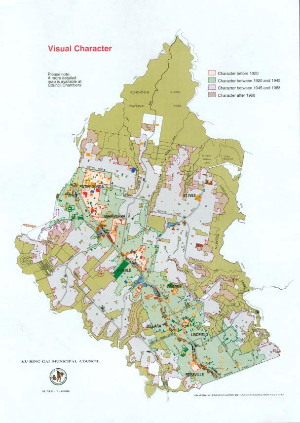
67 62
4.3 Dudley Area Plan. Introduction. History and Existing Character. Desired Future Character for Dudley
 4.3 Dudley Area Plan Introduction The suburb of Dudley has developed as a result of various circumstances including its topography, history and mineral resources. Dudley development has been identified
Part 9 Specific Land Uses - Housing on Small and Narrow Lots
 19 HOUSING ON SMALL AND NARROW LOTS This section of the DCP applies where development for the purpose of a dwelling house, attached dwellings, or semi-detached dwellings is or are proposed in the R2 Low
Draft Part 11 Heritage Area Plans West Wallsend / Holmesville
 TABLE OF CONTENTS: PART 1 WEST WALLSEND / HOLMESVILLE HERITAGE AREA PLAN... 3 1.1 INTRODUCTION... 3 1.2 BACKGROUND... 3 1.3 LAND TO WHICH THIS PLAN APPLIES... 3 PART 2 WEST WALLSEND / HOLMESVILLE HERITAGE
4 Residential and Urban Living Zones
 4 Residential and Urban Living Zones Refer to Chapters 11 to 20 for additional rules that may apply to these zones. 4.1 OBJECTIVES AND POLICIES Objective Res1 Policy 1 Policy 2 Policy 3 Policy 4 Policy
Cape Cabarita (Formerly known as the Wellcome Site) Development Control Plan. Date of Adoption: 4 September 2007 Effective Date: 7 March 2008
 Development Control Plan. Date of Adoption: 4 September 2007 Effective Date: 7 March 2008") Cape Cabarita (Formerly known as the Wellcome Site) Development Control Plan Date of Adoption: 4 September 2007 Effective Date: 7 March 2008 Development Control Plan Index 1 INTRODUCTION...3 1.1 LAND TO
Cape Cabarita (Formerly known as the Wellcome Site) Development Control Plan Date of Adoption: 4 September 2007 Effective Date: 7 March 2008 Development Control Plan Index 1 INTRODUCTION...3 1.1 LAND TO
medium desnity housing
 This section updated September 2013 This part of the Plan sets out the assessment criteria for medium density housing. The criteria are designed to give designers and builders flexibility and to provide
Development Control Plan
 Development Control Plan Liberty Grove Development Control Plan Date of Adoption: 4 September 2007 Effective Date: 7 March 2008 Index 1 INTRODUCTION... 3 1.1 NAME OF PLAN... 3 1.2 AREA TO WHICH THIS PLAN
Section Three, Appendix 17C Multiple Unit Housing Design Assessment Criteria
 APPENDIX 17C MULTIPLE UNIT HOUSING DESIGN ASSESSMENT CRITERIA Purpose of Appendix 17C In the Residential 9 Zone the construction and use of multiple household units located within the Multiple Household
Part 11 Heritage Area Plans West Wallsend / Holmesville
 TABLE OF CONTENTS: PART 1 WEST WALLSEND / HOLMESVILLE HERITAGE AREA PLAN... 3 1.1 INTRODUCTION... 3 1.2 BACKGROUND... 3 1.3 LAND TO WHICH THIS PLAN APPLIES... 3 PART 2 WEST WALLSEND / HOLMESVILLE HERITAGE
Development Control Plan
 Development Control Plan Single Dwellings on Lots at Breakfast Point Development Control Plan Date of Adoption: 4 September 2007 Effective Date : 7 March 2008 Single dwellings on Lots at Breakfast Point
22.15 OUTDOOR ADVERTISING SIGNAGE POLICY
 22.15 OUTDOOR ADVERTISING SIGNAGE POLICY This policy applies to all land where a planning permit is required to construct or display a sign under the provisions of the Kingston Planning Scheme. 22.15-1
Duplex Design Guidelines
 Duplex Design Guidelines Adopted by Council May 29, 2006 Prepared By: Table of Contents 1.0 Application and Intent 1 2.0 Areas of Application 2 3.0 Design Principles 3 4.0 Design Guidelines 4 4.1 Site
City of Vaughan Urban Design Guidelines for Infill Development in Established Low-Rise Residential Neighbourhoods
 City of Vaughan Urban Design Guidelines for Infill Development in Established Low-Rise Residential Neighbourhoods DRAFT - September 2016 Contents 1. Introduction 1 2. Policy Context 3 3. Characteristics
Development Control Plan
 Development Control Plan Rhodes Corporate Park (Also known as the Digital Site) Development Control Plan Date of Adoption: 4 September 2007 Effective Date: 7 March 2008 Index 1 INTRODUCTION... 3 1.1 LAND
Design and siting guidelines
 Design and siting guidelines Enhance your lifestyle Callaway Park an development 1 These Guidelines deal with the planning and development of the vacant residential land lots at Callaway Park. 2 Introduction
Section Three, Appendix 16C Medium Density Housing, Design Assessment Criteria (Residential 8A zone)
") APPENDIX 16C MEDIUM DENSITY HOUSING, DESIGN ASSESSMENT CRITERIA (RESIDENTIAL 8A ZONE) PURPOSE OF APPENDIX 16C (RESIDENTIAL 8A ZONE) In the Residential 8A Zone the following are defined as restricted discretionary
APPENDIX 16C MEDIUM DENSITY HOUSING, DESIGN ASSESSMENT CRITERIA (RESIDENTIAL 8A ZONE) PURPOSE OF APPENDIX 16C (RESIDENTIAL 8A ZONE) In the Residential 8A Zone the following are defined as restricted discretionary
Hurstville DCP No. 1 (Amendment No.5) Table of Contents
 Table of Contents") Hurstville DCP No. 1 (Amendment No.5) Section Table of Contents 1.0 Introduction 1 2.0 Application Process 2.1 Exempt and Complying Development 15 2.2 Neighbour Notification and Advertising of Development
Hurstville DCP No. 1 (Amendment No.5) Section Table of Contents 1.0 Introduction 1 2.0 Application Process 2.1 Exempt and Complying Development 15 2.2 Neighbour Notification and Advertising of Development
open space environment
 This section updated August 09 GUIDELINE TO THE RULES The Open Space Environment Rules apply to activities on sites within the Open Space Environment as shown on the Human Environments Maps. Most of the
AMENDMENTS. Date Effective. Amendment No. Council. DCP 14 Davidson St, Greenacre Page 2
 AMENDMENTS Amendment No. Description Adopted by Council Date Effective DCP 14 Davidson St, Greenacre Page 2 TABLE OF CONTENTS 1.0 INTRODUCTION... 4 1.1 NAME OF THIS PLAN... 4 1.2 COMMENCEMENT OF DEVELOPMENT
MEDIUM DENSITY RESIDENTIAL DEVELOPMENT
 MEDIUM DENSITY RESIDENTIAL DEVELOPMENT KU-RING-GAI COUNCIL DEVELOPMENT CONTROL PLAN 48 [Applicable to zones 2(d), 2(e) and 2(h)] RC: 93 Cost: $15.00 Ku-ring-gai Council 818 Pacific Highway, Gordon 9424
4 RESIDENTIAL ZONE. 4.1 Background
 4 RESIDENTIAL ZONE 4.1 Background The residential areas within the City are characterised by mainly lowrise dwellings sited on individual allotments. Past architectural styles, settlement patterns and
Water Sensitive Urban Design Site Development Guidelines and Practice Notes. Appendix
 Water Sensitive Urban Design Site Development Guidelines and Practice Notes Appendix 108 Appendix A Water sensitive developments involve simple design and management practices that take natural site features
Private Tennis Courts
 Private Tennis Courts Sutherland Shire Council 9.2/03 edition 3 Contents 1. Where does the Plan apply? 2. What is the purpose of the Plan? 3. Can the Plan be varied? 4. Making an application 5. Site and
Advisory notes. Design and siting of buildings and structures. Purpose of these notes. Building setbacks and site coverage.
 Advisory notes Design and siting of buildings and structures Purpose of these notes The design and siting of buildings and structures within the City of Gold Coast (the City) is regulated by a combination
Infill Residential Design Guidelines
 Infill Residential Design Guidelines Adopted March 23, 2004 Amended September 10, 2013 City of Orange Community Development Department Planning Division Phone: (714) 744-7220 Fax: (714) 744-7222 www.cityoforange.org
Vision Statement for Point Lonsdale
 TOWNSHIP BROCHURE This Township Brochure applies to all of Point Lonsdale (CoGG). Please see overleaf for precinct map and refer to the individual Precinct Brochure for your area. Vision Statement for
I539. Smales 2 Precinct
 I539. Smales 2 Precinct I539.1. Precinct Description The Smales 2 Precinct applies to a 4.8 hectare block of land located on the southern side of Northcote Road and fronting Lake Pupuke, Takapuna. The
Section 6A 6A Purpose of the Natural Features and Landscapes Provisions
 Section 6A 6A Purpose of the Natural Features and Landscapes Provisions This Chapter addresses the protection and management of natural features and landscapes within the City. The City has a number of
RESIDENTIAL ACTIVITY PERFORMANCE STANDARDS
 Preferred Options Consultation Q&A Sheet RESIDENTIAL ACTIVITY PERFORMANCE STANDARDS What are the key goals for managing the design of residential buildings in the Second Generation Plan (2GP)? The key
Intentional blank page
 Intentional blank page Intentional blank page Contents 1.0 INTRODUCTION 1 1.1 Name 1 1.2 Date of Adoption 1 1.3 Aim 1 1.4 Land to Which This Plan Applies 1 1.5 Relationship to Other Plans and Legislation
Chapter 13 Residential Areas: Appendices APPENDIX 1 Residential Areas
 Chapter 13 Residential Areas: Appendices Page 1 Chapter 13 Residential Areas: Appendices APPENDIX 1 Residential Areas Design Code for Intensive Housing INTRODUCTION DESIGN ELEMENTS A NEIGHBOURHOOD DESIGN
APPENDIX MATAKANA COMMERCIAL URBAN DESIGN GUIDELINES
 APPENDIX MATAKANA COMMERCIAL URBAN DESIGN GUIDELINES 1.0 INTRODUCTION The following urban design guidelines are to be utilised by landowners, planners and other persons involved in development at early
2 Status of the Design Guidelines The Design Controls are to be applied to each of the residential titles by way of consent notices.
 6 October 2015 HARAKEKE 2015 LTD DESIGN CONTROLS 1 Introduction The Design s apply to all of the buildings to be erected in the Harakeke Subdivision on the sites 101-130, 201-232, 301-322, 401-426, and
Urban Design Guidelines Townhouse and Apartment Built Form
 Urban Design Guidelines Townhouse and Apartment Built Form Town of Wasaga Beach Table of Contents 1. Introduction 1.1. Purpose 1.2. Urban Design Principles 1.3. Application of Guidelines 2. Site Design,
Section 12C Subdivision in the Rural Residential Zone
 Section 12C 12C Subdivision in the Rural Residential Zone The Rural Residential Zone provides part of the range of residential opportunities within the City. Land zoned rural residential is considered
3 Abbey View Mill Hill London NW7 4PB
 Location 3 Abbey View Mill Hill London NW7 4PB Reference: 15/03203/HSE Received: 26th May 2015 Accepted: 16th June 2015 Ward: Mill Hill Expiry 11th August 2015 Applicant: Proposal: Mr Richard Benson Alterations
statement of environmental effects
 for single dwelling houses, granny flats and associated ancillary structures only property details Please provide the following details Lot N o/s. Section N o. DP N o. A statement of environmental effects
PLANNING COMMITTEE. 14 October 2014
 AGENDA ITEM NO 8 PLANNING COMMITTEE 14 October 2014 APPLICATION NUMBER : CA//14/01744/FUL PROPOSAL : Extension and conversion of roof space of an existing detached bungalow together with enhanced parking
Wide asphalt driveway abutting school property. garage built with incompatible materials, too close to park. incompatible fencing materials
 Wide asphalt driveway abutting school property incompatible fencing materials garage built with incompatible materials, too close to park Lack of plantings as a buffer between private property and open
Design Guidelines - 1 -
 Design Guidelines REAR YARDS Rear yard decks and porches, attached to a garden or garage suite, should be permitted provided minimum rear yard setbacks, separation distances, and necessary site access
1 The development hereby permitted shall be carried out in accordance with the following approved plans:
 Location 59 Greenway Close London N20 8ES Reference: 16/00011/HSE Received: 30th December 2015 Accepted: 7th January 2016 Ward: Totteridge Expiry 3rd March 2016 Applicant: Mr Ankit Shah Proposal: Part
2 Nelson City Council Dear Cottages
 2 Nelson City Council Dear Cottages Design Guide introduction DI1 Why a Design Guide? The Council, in the development of the Nelson Resource Management Plan, has identified particular residential areas
DESIGN GUIDANCE NOTE NO: 5 EXTENSIONS TO HOUSES
 DESIGN GUIDANCE NOTE NO: 5 EXTENSIONS TO HOUSES This note is one of a series providing design guidance for development in the borough. It explains the criteria used by the council to decide planning applications
Ground Floor Flat 15 Redbourne Avenue London N3 2BP
 Location Ground Floor Flat 15 Redbourne Avenue London N3 2BP Reference: 17/4160/FUL Received: 28th June 2017 Accepted: 29th June 2017 Ward: West Finchley Expiry 24th August 2017 Applicant: Proposal: Mr
SECTION ONE North East Industrial Zone Design Guide Palmerston North City Council June 2004
 SECTION ONE North East Industrial Zone Design Guide Palmerston North City Council June 2004 young heart easy living 1 Preface Industrial areas are a very important component of the economic well-being
I615. Westgate Precinct
 I615. Westgate Precinct I615.1. Precinct Description The Westgate Precinct is located approximately 18km west of the Auckland city centre. There are seven Sub-precincts in the Westgate Precinct: Sub-precinct
APPENDIX 10 THE RESIDENTIAL DESIGN GUIDE FOR DEVELOPMENTS IN RESIDENTIAL ZONES IN SPECIFIED GROWTH AREAS
 THE RESIDENTIAL DESIGN GUIDE FOR DEVELOPMENTS IN RESIDENTIAL ZONES IN SPECIFIED GROWTH AREAS ISTHMUS SECTION - OPERATIVE 1999 Page 1 CONTENTS... PAGE 1.0 INTRODUCTION... 4 1.1 Growth Management Strategy...
SCHEDULE 12 TO THE DESIGN AND DEVELOPMENT OVERLAY GLEN WAVERLEY ACTIVITY CENTRE STRUCTURE PLAN
 DD/MM/YY Proposed C120 SCHEDULE 12 TO THE DESIGN AND DEVELOPMENT OVERLAY Shown on the planning scheme map as DDO12. GLEN WAVERLEY ACTIVITY CENTRE STRUCTURE PLAN 1.0 Design objectives DD/MM/YY Proposed
Lake Macquarie Development Control Plan 2014 Revision 17
 Lake Macquarie Development Control Plan 2014 Revision 17 Part 3 Development within Residential Zones Draft LMCC DCP 2014 Page 1 F2009/00952 Version 4 Exhibition Draft July 2012 TABLE OF CONTENTS: 1 INTRODUCTION...
Commercial Development Permit Area
 City of Kamloops KAMPLAN Commercial Development Permit Area PURPOSE The purpose of this Development Permit Area (DPA) is to establish objectives and provide guidelines for the form and character of commercial
Division 13 Local Business and Industry Buffer Zone: Assessment Criteria and Assessment Tables
 Division 13 Local Business and Industry Buffer Zone: Assessment Criteria and Assessment Tables 4.13.1 Local Business and Industry Buffer Zone The provisions in this division relate to the Local Business
Development Control Plan
 Development Control Plan Abbotsford Cove (Also known as the Former Nestle Site) Development Control Plan Date of Adoption: 4 September 2007 Effective Date: 7 March 2008 Index 1 INTRODUCTION... 3 1.1 ENVIRONMENTAL
Housing and Coach House Guidelines - Ladner
 Housing and Coach House Guidelines - Ladner Policy D.8: Encourage Compatible Housing Design Encourage housing design that is sensitive to existing single family housing neighbourhoods by requiring a design
Eastern Golf Course, Doncaster Road, Doncaster
 , 463-535 Road, Heritage Assessment in accordance with Schedule to the Development Plan Overlay July 2013 bryce raworth conservation urban design 19 Victoria Street St Kilda Vic 3182 , 463-535 Road, Heritage
Division 7 Character Areas Housing Zone: Assessment Criteria and Assessment Tables
 Division 7 Character Areas Housing Zone: Assessment Criteria and Assessment Tables 4.7.1 Character Areas Housing Zone The provisions in this division relate to the Character Areas Housing Zone as follows
SECTION 7A: WHAKARONGO RESIDENTIAL AREA
 SECTION 7A: WHAKARONGO RESIDENTIAL AREA CONTENTS 7A.1 Introduction 1 7A.2 Resource Management Issues 1 7A.3 Objectives and Policies 1 7A.4 Methods 4 7A.5 Residential Zone 4 7A.5.1 Rules: Controlled Activities
GUIDELINES REPLACEMENT HOUSING GUIDELINES LOCATION INTRODUCTION URBAN DESIGN GUIDELINES
 Replacement housing in the former City of North York will be consistent with the following urban design guidelines. They provide a framework for residential re-development in the former City of North York
AOTEA SUPERMARKET ZONE. Zone Introduction
 C18 AOTEA SUPERMARKET ZONE Zone Introduction C18.1 Objective This zone identifies a specific area in Aotea for a stand alone supermarket. The zone is site specific and has a range of objectives, policies
3 Tretawn Gardens London NW7 4NP
 Location 3 Tretawn Gardens London NW7 4NP Reference: 16/7886/HSE Received: 12th December 2016 Accepted: 19th December 2016 Ward: Mill Hill Expiry 13th February 2017 Applicant: Proposal: Mr Murray Two storey
PART AOTEA PRECINCT
 CONTENTS... PAGE AOTEA PRECINCT...4 14.5.1 INTRODUCTION...4 14.5.2 RESOURCE MANAGEMENT ISSUES...4 14.5.3 RESOURCE MANAGEMENT OBJECTIVES AND POLICIES... 4 14.5.4 RESOURCE MANAGEMENT STRATEGY...5 14.5.5
SCHEDULE THREE TO THE DEVELOPMENT PLAN OVERLAY EASTERN GOLF COURSE KEY REDEVELOPMENT SITE
 DD/MM/YY SCHEDULE THREE TO THE DEVELOPMENT PLAN OVERLAY Shown on the planning scheme map as DPO3 EASTERN GOLF COURSE KEY REDEVELOPMENT SITE 1.0 A permit may be granted before a development plan has been
NORTH EAST INDUSTRIAL ZONE
 SECTION 12A: NORTH EAST INDUSTRIAL ZONE CONTENTS 12A.1 Introduction 1 12A.2 Resource Management Issues 2 12A.3 Objectives and Policies 3 12A.4 Rules: Permitted Activities 8 R12A.4.1 Permitted Activities
Derry City and Strabane District Council Planning Committee Report
 Derry City and Strabane District Council Planning Committee Report COMMITTEE DATE: 23 rd March 2016 APPLICATION No: APPLICATION TYPE: PROPOSAL: LOCATION: APPLICANT: LA11/2015/0395/F Residential Development
Subdivision Design Criteria. Penihana North GUIDELINES TO THE RULES
 Created September 2013 Penihana North Subdivision Design Criteria GUIDELINES TO THE RULES This part of the Plan sets out the design criteria for subdivision in Penihana North. The criteria will be considered
RURAL ZONE - POLICY. Rural Zone Policy. Issue: Rural Environment. Ruapehu District Plan Page 1 of 8
 Rural Zone Policy RU2 RURAL ZONE - POLICY RU2.1 Introduction The natural resources of the rural environment in the Ruapehu District provide the basis for the existing and potential character, intensity
B L A C K D I A M O N D D E S I G N G U I D E L I N E S for Multi-family Development
 B L A C K D I A M O N D D E S I G N G U I D E L I N E S for Multi-family Development Adopted June 18, 2009 This section of the Design and focuses on site planning and design guidance for new multi-family
Lake Macquarie Development Control Plan 2014 Revision 20
 Lake Macquarie Development Control Plan 2014 Revision 20 TABLE OF CONTENTS: 1 INTRODUCTION... 3 1.1 HOW TO USE THIS PLAN... 3 1.2 ADDITIONAL CONTROLS FOR SPECIFIC LAND USES... 3 1.3 AIMS FOR DEVELOPMENT
MATURE SUBURBS RESIDENTIAL DEVELOPMENT GUIDELINES
 MATURE SUBURBS RESIDENTIAL DEVELOPMENT GUIDELINES DRAFT FEBRUARY 2005 BIRMINGHAM CITY COUNCIL 1 Introduction Mature Suburbs Residential Development Guidelines - Interim Supplementary Planning Advice -
Lake Macquarie Development Control Plan Revision 20
 Lake Macquarie Development Control Plan 2014 - Revision 20 LMCC DCP 2014 Revision 20 Page 0 F2016/01470 TABLE OF CONTENTS: 1 INTRODUCTION... 3 1.1 HOW TO USE THIS PLAN... 3 1.2 ADDITIONAL CONTROLS FOR
DESIGN GUIDELINES. Oakdene Estate at Ocean Grove Grubb Road, Ocean Grove
 DESIGN GUIDELINES Oakdene Estate at Ocean Grove 162 240 Grubb Road, Ocean Grove TABLE OF CONTENTS INTRODUCTION... 3 1. HOUSE DESIGN APPROVAL PROCESS... 4 1.01 DESIGN PANEL FOR RESIDENTIAL DEVELOPMENT...
Nelson Residential Street Frontage Guideline
 DRAFT 22-06-2012 Nelson Residential Street Frontage Guideline June 2012 1317273 Contents and purpose Residential s are important Residential s are much more than corridors which move traffic. Streets allow
Rural (Urban Expansion) Environment
 Environment") RUEE.1 Rural (Urban Expansion) Environment Subsequent to the receipt of appeals, a 'marked up' version of the Proposed District Plan was prepared. The provisions of the Proposed Version of the Plan subject
RUEE.1 Rural (Urban Expansion) Environment Subsequent to the receipt of appeals, a 'marked up' version of the Proposed District Plan was prepared. The provisions of the Proposed Version of the Plan subject
CA.1 Coastal Area. Index. CA.1.1 Description and Expectations
 Index.1.2.3.4 CA.2 CA.2.1 CA.2.2 CA.2.3 CA.3 CA.3.1 CA.3.2 CA.3.1 CA.4 CA.4.1 CA.4.2 CA.4.3 CA.4.4 CA.5 CA.5.1 CA.5.2 Description and Expectations Objectives Policies Guidance Note Landuse Eligibility
The Proposed Auckland Unitary Plan (notified 30 September 2013)
") 3 Business zones Introduction There are 10 business zones in the Unitary Plan: City Centre Metropolitan Centre Town Centre Local Centre Neighbourhood Centre Mixed Use General Business Business Park Light
3 Business zones Introduction There are 10 business zones in the Unitary Plan: City Centre Metropolitan Centre Town Centre Local Centre Neighbourhood Centre Mixed Use General Business Business Park Light
UNITARY PLAN. Your Easy Guide to understanding the Residential Standards. Version 35. waste. outlook. landscapes. context. parking
 UNITARY PLAN Your Easy Guide to understanding the Residential Standards waste outlook landscapes height context fencing parking street interface daylight Version 35 June March 2017 2018 The Easy Guide
CONTENTS 8.0 LAND USE 8.1 GENERAL LAND USE 8.2 RESIDENTIAL 8.3 MIXED USE 8.4 COMMERCIAL 8.5 EMPLOYMENT LANDS
 8-2 Land Use 8.0 LAND USE CONTENTS 8.1 GENERAL LAND USE 8.1.1 Uses provided for in all Land Use Designations 8.1.2 Uses prohibited in Hazardous Lands, Hazardous Sites and Special Policy Areas 8.1.3 Uses
REFERENCE: B/03745/12 Received: 02 October 2012 Accepted: 05 October 2012 WARD(S): Totteridge Expiry: 30 November 2012.
: Totteridge Expiry: 30 November 2012.") LOCATION: 15A Pyecombe Corner, London, N12 7AJ REFERENCE: B/03745/12 Received: 02 October 2012 Accepted: 05 October 2012 WARD(S): Totteridge Expiry: 30 November 2012 Final Revisions: APPLICANT: PROPOSAL:
LOCATION: 15A Pyecombe Corner, London, N12 7AJ REFERENCE: B/03745/12 Received: 02 October 2012 Accepted: 05 October 2012 WARD(S): Totteridge Expiry: 30 November 2012 Final Revisions: APPLICANT: PROPOSAL:
49 Broughton Avenue London N3 3EN
 Location 49 Broughton Avenue London N3 3EN Reference: 17/3448/RCU Received: 30th May 2017 Accepted: 1st June 2017 Ward: Finchley Church End Expiry 27th July 2017 Applicant: Mr P Atwal Proposal: Erection
MASTER PLAN NO. 62 (SITE DEVELOPMENT PLAN BIRTINYA VILLAGE CENTRE) 2009
 2009") Development Agreement, Development Control Plan 1 - Kawana Waters and Section 6.1.45A (Development Control Plans under Repealed Act) of the Integrated Planning Act 1997 MASTER PLAN NO. 62 (SITE DEVELOPMENT
Development Agreement, Development Control Plan 1 - Kawana Waters and Section 6.1.45A (Development Control Plans under Repealed Act) of the Integrated Planning Act 1997 MASTER PLAN NO. 62 (SITE DEVELOPMENT
1 The development hereby permitted shall be carried out in accordance with the following approved plans:
 Location The Avenue Tennis Club The Avenue London N3 2LE Reference: 16/6509/FUL Received: 10th October 2016 Accepted: 10th October 2016 Ward: Finchley Church End Expiry 5th December 2016 Applicant: Mrs
Proposed for Vic West Neighbourhood Plan. Design Guidelines for Intensive Residential Development - Townhouse and Attached Dwelling
 Proposed for Vic West Neighbourhood Plan Design Guidelines for Intensive Residential Development - Townhouse and Attached Dwelling Design Guidelines for Intensive Residential Development - Townhouse and
PLANNING INSTITUTE OF AUSTRALIA, NSW DIVISION SUBMISSION ON THE NSW DRAFT HOUSING CODE AND NSW DRAFT COMMERCIAL CODE
 PLANNING INSTITUTE OF AUSTRALIA, NSW DIVISION SUBMISSION ON THE NSW DRAFT HOUSING CODE AND NSW DRAFT COMMERCIAL CODE This Submission provides detailed comment on draft Codes following feedback from PIA
Reference: 16/1234/HSE Received: 25th February 2016 Accepted: 2nd March 2016 Ward: High Barnet Expiry 27th April 2016
 Location 7 Sunset View Barnet EN5 4LB Reference: 16/1234/HSE Received: 25th February 2016 Accepted: 2nd March 2016 Ward: High Barnet Expiry 27th April 2016 Applicant: Proposal: Mr & Mrs Peter & Anny Woodhams
Reference: 16/1447/FUL Received: 7th March 2016 Accepted: 7th March 2016 Ward: East Finchley Expiry 2nd May 2016
 Location 374B Long Lane London N2 8JX Reference: 16/1447/FUL Received: 7th March 2016 Accepted: 7th March 2016 Ward: East Finchley Expiry 2nd May 2016 Applicant: Ms Katrin Hirsig Proposal: Single storey
SOUTH CAMBRIDGESHIRE DISTRICT COUNCIL. Executive Director (Operational Services) Corporate Manager (Planning and New Communities)
 Corporate Manager (Planning and New Communities)") SOUTH CAMBRIDGESHIRE DISTRICT COUNCIL REPORT TO: Planning Committee 12 January 2011 AUTHOR/S: Executive Director (Operational Services) Corporate Manager (Planning and New Communities) Notes: S/1848/10
SOUTH CAMBRIDGESHIRE DISTRICT COUNCIL REPORT TO: Planning Committee 12 January 2011 AUTHOR/S: Executive Director (Operational Services) Corporate Manager (Planning and New Communities) Notes: S/1848/10
1 The decision of the Responsible Authority is affirmed. 2 In permit application WH/2014/851, no permit is granted.
 VICTORIAN CIVIL AND ADMINISTRATIVE TRIBUNAL ADMINISTRATIVE DIVISION PLANNING AND ENVIRONMENT LIST VCAT REFERENCE NO. P754/2015 PERMIT APPLICATION NO.WH/2014/851 CATCHWORDS Section 77 of the Planning and
RESIDENTIAL GUIDELINES CHECKLIST
 RESIDENTIAL GUIDELINES CHECKLIST The following checklist was created to provide you with an easy way to ensure that your project complies with the Residential Design Guidelines. RESIDENTIAL DESIGN GUIDELINES
CONTENTS 5. TOURIST ACCOMMODATION STRATEGIC LAND USE PLAN... 30
 MURRAY DEVELOPMENT CONTROL PLAN 2012 CONTENTS 1. INTRODUCTION... 1 1.1 Title... 1 1.2 Land to which this DCP applies... 1 1.3 Purpose... 1 1.4 Operation... 1 1.5 Relationship with other planning instruments...
Reference: 15/06961/RCU Received: 13th November 2015 Accepted: 17th November 2015 Ward: Coppetts Expiry 12th January 2016
 Location 91 Manor Drive London N20 0XD Reference: 15/06961/RCU Received: 13th November 2015 Accepted: 17th November 2015 Ward: Coppetts Expiry 12th January 2016 Applicant: Mr Christos Papadopoulos Proposal:
Intentional blank page
 Intentional blank page Intentional blank page Contents 1.0 INTRODUCTION... 1 1.1 Name... 1 1.2 Date of Adoption... 1 1.3 Aim... 1 1.4 Land to Which This Plan Applies... 1 1.5 Relationship to Other Plans,
15 Rural Residential Zone
 15 Rural Residential Zone Section 15A 15A Purpose of the Rural Residential Zone... 1 15A.1 Objectives and Policies of the Rural Residential Zone... 1 15A.2 Activity Status Rules... 5 15A.3 Permitted Activity
13. New Construction. Context & Character
 13. New Construction Context & Character While historic districts convey a sense of time and place which is retained through the preservation of historic buildings and relationships, these areas continue
ENHANCED ACCESSIBILITY GUIDELINES
 City of Vancouver Land Use and Development Policies and Guidelines Planning and Development Services, 453 W. 12th Ave Vancouver, BC V5Y 1V4 F 604.873.7344 fax 604.873.7060 planning@vancouver.ca ENHANCED
Case Officer: Sarah Kay File No: CHE/14/00515/REM Tel. No: (01246) Plot No: 2/6132 Ctte Date: 15 th September 2014 ITEM 1
 Plot No: 2/6132 Ctte Date: 15 th September 2014 ITEM 1") Case Officer: Sarah Kay File No: CHE/14/00515/REM Tel. No: (01246) 345786 Plot No: 2/6132 Ctte Date: 15 th September 2014 ITEM 1 APPROVAL OF RESERVED MATTERS FROM APPLICATION CHE/12/00234/OUT (1) LAYOUT,
Case Officer: Sarah Kay File No: CHE/14/00515/REM Tel. No: (01246) 345786 Plot No: 2/6132 Ctte Date: 15 th September 2014 ITEM 1 APPROVAL OF RESERVED MATTERS FROM APPLICATION CHE/12/00234/OUT (1) LAYOUT,
LITHGOW CITY COUNCIL DEVELOPMENT CONTROL PLAN ADI LIMITED SITE LITHGOW SMALL ARMS FACTORY METHVEN STREET, LITHGOW
 LITHGOW CITY COUNCIL DEVELOPMENT CONTROL PLAN ADI LIMITED SITE LITHGOW SMALL ARMS FACTORY METHVEN STREET, LITHGOW 6 November 2003 CONTENTS Page 1. INTRODUCTION 1.1 Purpose 1 1.2 Citation 1 1.3 Adoption
Section 3b: Objectives and Policies Rural Environment Updated 19 November 2010
 Page 1 of Section 3b 3b RURAL ENVIRONMENT 3b.1 Introduction The Rural Environment comprises all the land outside of the Residential, Town Centre and Industrial Environments. Most land within the District
7.2.9 Eudlo local plan code
 7.2.9 local plan code 7.2.9.1 Application (1) This code applies to assessable development:- (a) within the local plan area as shown on Map ZM29 contained within Schedule 2 (Mapping); and (b) identified
Rural (Urban Expansion) Environment
 Environment") RUEE.1 Rural (Urban Expansion) Environment Index RUEE.1 RUEE.1.1 RUEE.1.2 RUEE.1.3 RUEE.1.4 RUEE.2 RUEE.2.1 RUEE.2.2 RUEE.2.3 RUEE.2.4 RUEE.3 Rural (Urban Expansion) Environment Description and Expectations
RUEE.1 Rural (Urban Expansion) Environment Index RUEE.1 RUEE.1.1 RUEE.1.2 RUEE.1.3 RUEE.1.4 RUEE.2 RUEE.2.1 RUEE.2.2 RUEE.2.3 RUEE.2.4 RUEE.3 Rural (Urban Expansion) Environment Description and Expectations
SUSTAINABLE MANAGEMENT
 . Sustainable Management.1 The Concept of Sustainable Management The concept of sustainable management recognises there are limits to the use of natural and physical resources and there is a need to balance
Statement of compliance
 Project Number SJ-06087 Sydney CityGrid Project Appendix C Statement of compliance 21 February 2012 Tables of Compliance Table 1 Sydney Local Environmental Plan 2005 Part 1 Preliminary 10. Waiver of certain