LITHGOW CITY COUNCIL DEVELOPMENT CONTROL PLAN ADI LIMITED SITE LITHGOW SMALL ARMS FACTORY METHVEN STREET, LITHGOW
|
|
|
- Roderick Shaw
- 5 years ago
- Views:
Transcription
1 LITHGOW CITY COUNCIL DEVELOPMENT CONTROL PLAN ADI LIMITED SITE LITHGOW SMALL ARMS FACTORY METHVEN STREET, LITHGOW 6 November 2003
2 CONTENTS Page 1. INTRODUCTION 1.1 Purpose Citation Adoption Land to Which This Plan Applies 1 2. ADMINISTRATION 2.1 Consultation Documentation Lodgement of a Development Application Notification and Advertising Referral to Government Authorities Assessment 3. PLANNING CONTEXT AND OBJECTIVES 3.1 Lithgow Local Environmental Plan Objectives of the DCP 7 4. DEVELOPMENT CONTROLS BUILDINGS AND STRUCTURES 4.1 The Development Control Framework Site Analysis Heritage Building Design Setbacks Landscaping Vehicular Access and Parking Fencing Design for Access and Mobility Waste Management Soil and Water Quality, Noise Management Advertising Signs Services DEVELOPMENT CONTROLS - SUBDIVISION 5.1 Lot Size and Dimension Subdivision Design Open Space and Landscaping Infrastructure Stormwater Management Water Quality Management APPENDIX A - DEFINITIONS APPENDIX B - INFORMATION REQUIRED WITH A DEVELOPMENT APPLICATION
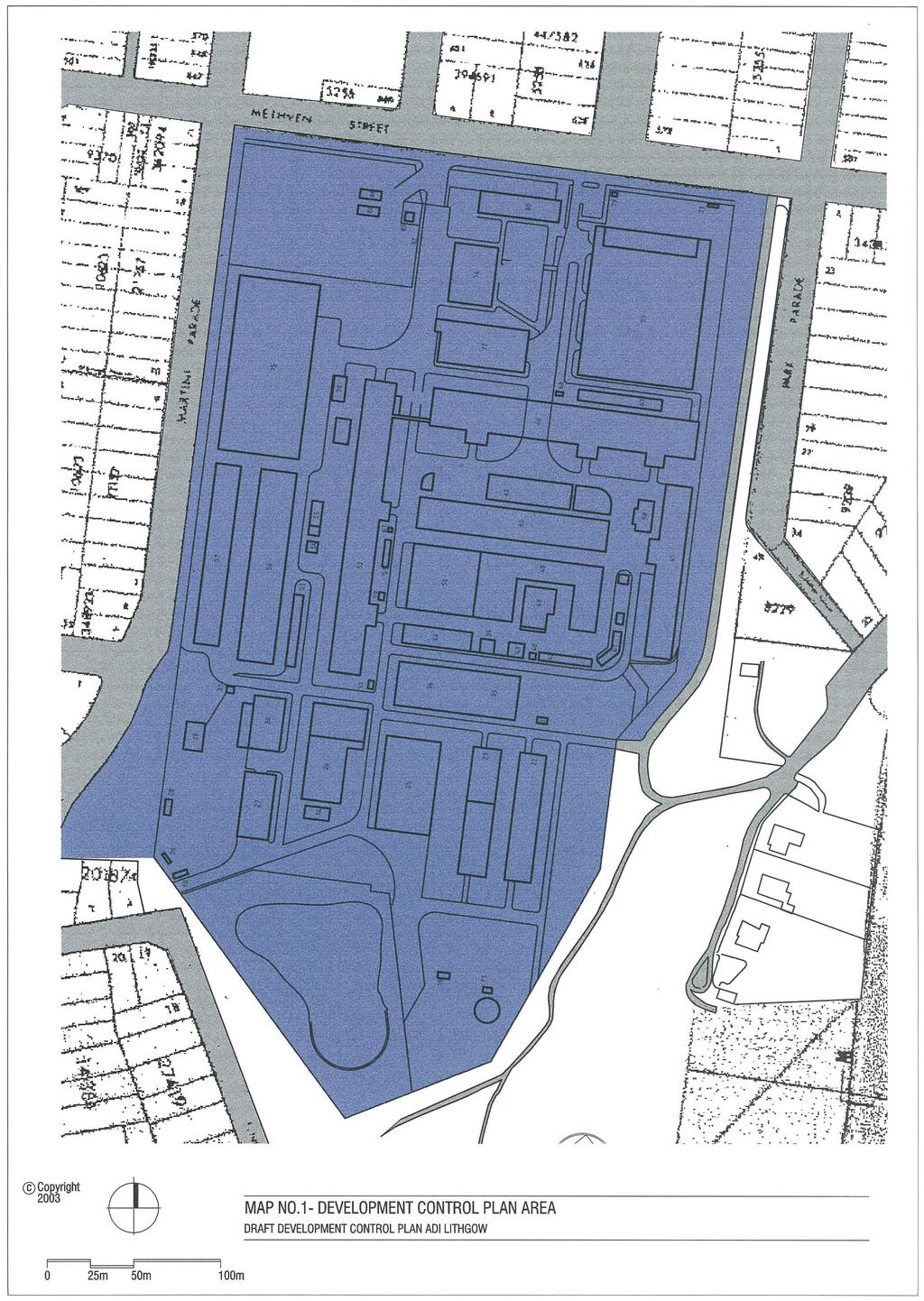
3 DRAFT DEVELOPMENT CONTROL PLAN ADI LIMITED SITE, LITHGOW 1 1. INTRODUCTION 1.1 Purpose This Draft Development Control Plan has been prepared in accordance with Section 72 of the Environmental Planning and Assessment Act, 1979 and Part 3 of the EPA Regulation 2000 to provide a sitespecific development framework. The DCP identifies Objectives, performance Criteria and Requirements (numerical controls) to guide and control adaptive reuse and redevelopment of the existing industrial facility. The DCP is made under Lithgow Local Environmental Plan, 1994 and conforms with its statutory provisions. The DCP is to be read in conjunction with the following planning instruments. Lithgow Local Environmental Plan, The provisions of the DCP must be taken into consideration in the assessment of development applications for the site pursuant to Section 79C(1)(a)(iii) of the Environmental Planning and Assessment Act, Citation This Development Control Plan may be cited as City of Lithgow Development Control Plan ADI Limited Site, Lithgow. 1.3 Adoption This plan was adopted by Council pursuant to Section 72 of the EPA Act, 1979 and Regulation and came into effect on 6 November Land to Which This Plan Applies The Plan applies to the industrial developed portion of the ADI Site, including the consolidation of the Lithgow Small Arms Factory, Methven Street, Lithgow; identified in Figure 1. The current legal description of the land is DP Lot 1, City of Lithgow Council, Parish of Lett, County of Cook. 1.5 Relationship to Other Plans and Policies
4 DRAFT DEVELOPMENT CONTROL PLAN ADI LIMITED SITE, LITHGOW 2 2. ADMINISTRATION 2.1 Consultation Developers are encouraged to use the services of qualified professionals in the preparation of development proposal, and provision of supporting information. It is desirable to consult the adjoining owners during formulation of the development proposal. Council strongly recommends that applicants hold prelodgment meeting with Council s officers to discuss the proposed development and to determine the matters and issues that need to be addressed in the development application and supporting information. Pre-lodgment meetings can be arranged by contacting Council s Environmental and Planning Services Division on Council s address and phone numbers are provided below:- Postal Address: The General Manager Lithgow City Council PO Box 19 LITHGOW NSW 2790 Address: Administration Building 180 Mort Street LITHGOW NSW 2790 Telephone: Facsimile: Office Hours: Council officers are generally available between the hours of 8.15am and 4.30pm or by appointment. Consultation should also take place with Council on the availability of water and sewerage services, limitations on discharges and whether amplification of services or other charges will be involved. Other servicing authorities should also be consulted as required including Integral Energy, the AGL Company, Public Works etc. 2.2 Documentation Information to be submitted with a development application is listed in Appendix B. 2.3 Lodgment of a Development Application Development applications are to be lodged with Council s Environmental and Planning Services Division. If you wish to lodge a development application it is recommended but not essential that you make an appointment with Council on telephone (02) Notification and Advertising Upon receiving a development application, Council will notify adjoining and neighbouring landowners in writing of the development application. Some developments will also be advertised in the local press. When adjoining and neighbouring landowners are to be notified of a development application the period of exhibition will be a minimum period of 14 days unless otherwise prescribed by the EPA Act Regulation. A fee will be levied on the applicant for the cost of notification of the development application. The fee will be payable at the time of lodgment of the development application. 2.5 Referral to Government Authorities Council may determine to refer for reasons other than Integrated Development Assessment, a development application to one or more Government Authorities for their comments, such as the Roads and Traffic Authority, Environment Protection Authority or NSW Heritage Office.
5 DRAFT DEVELOPMENT CONTROL PLAN ADI LIMITED SITE, LITHGOW Assessment The development application will be assessed and determined by Council having regard to the following matters:- Section 79C(1) of the Environmental Planning and Assessment Act, Any relevant State or Regional Planning Policy. The aims, objectives and land use provisions of City of Lithgow LEP1994. The provisions of this Development Control Plan. The provisions of any relevant Council s Codes, DCP s or Policies.
6 DRAFT DEVELOPMENT CONTROL PLAN ADI LIMITED SITE, LITHGOW 4 3. PLANNING CONTEXT AND OBJECTIVES 3.1 Lithgow LEP1994 The Lithgow LEP 1994 provides the statutory planning framework to guide the growth of the City of Lithgow in the 21st Century. The aims of the Lithgow Local Environmental Plan 1994 are:- (a) to recognise and promote the City of Greater Lithgow as a desirable and viable place in which to live and visit and invest; (b) to encourage the proper management, development and conservation of natural resources and the built environment within the City of Greater Lithgow by protecting, enhancing or conserving:- (i) prime crop and pasture land; (ii) timber, minerals, soil, water quality, stream environment and other natural resources; (iii) places of significance for nature or heritage conservation; (iv) places or features of high scenic or recreational value; and (c) to replace the former local planning controls with a comprehensive local environmental plan to help facilitate growth and development of the City of Greater Lithgow in a manner which is consistent with the aims specified in paragraph (a) and which:- (i) minimises the environmental cost to the community of fragmented and isolated development of rural land which has less than full provision of services; (ii) facilitates the efficient and effective provision of amenities and services; (iii) facilitates a range of residential and employment opportunities in accordance with demand; (iv) facilitates farm adjustments; (v) ensures that the safety and efficiency of arterial roads is not adversely affected by development on adjacent land; (vi) minimises the impact of flooding and bushfires; (vii) encourages the separation of conflicting land uses; (viii) establishes measures to preserve water quality in the City s streams and waterways; and (ix) facilitates the protection of the catchment areas within and downstream of the City area in accordance with the principles of total catchment management. 3.2 Objectives of the DCP The provisions of the DCP are formulated to achieve the relevant aims of the Lithgow LEP1994 through appropriate performance criteria and requirements. The objectives of the DCP are:- (1) Utilise, where practicable, the existing physical infrastructure and maintain the long association of the Small Arms Factory with Lithgow. (2) Provide industrial allotments of varying sizes that can be economically developed to suit modern light industrial, high technology and service facilities and provide local employment. (3) Facilitate adaptive reuse of buildings of significance, which are structurally and economically suited for adaptation. (4) To promote energy conservation and environmentally sustainable industrial development. (5) To encourage improvements to the character and appearance of industrial development and promote visual and operational compatibility with residential areas. (6) To protect the amenity and health of the residents as well as the
7 DRAFT DEVELOPMENT CONTROL PLAN ADI LIMITED SITE, LITHGOW 5 environmental assets including air, water, soil and native vegetation.
8 DRAFT DEVELOPMENT CONTROL PLAN ADI LIMITED SITE, LITHGOW 6 4. DEVELOPMENT CONTROLS BUILDINGS AND STRUCTURES 4.1 The Development Control Framework The DCP adopts performance based development control approach that focuses on desired outcomes outlined in objectives and performance criteria. Prescriptive, numerical controls (requirements) are provided to illustrate one possible means of advising the objectives. The performance based development control approach seeks to achieve environmentally and aesthetically acceptable results while allowing flexibility and encouraging innovative design. Each design element of the DCP comprises a set of objectives, performance criteria and where applicable, requirements (numerical controls). Objectives state the purpose of the controls and the desired outcomes relating to the particular design element. the objectives are deemed to be achieved by meeting the performance criteria or requirements. Performance criteria specify the means to achieve the objectives. They provide a guide to best practice concerning design and amenity and encourage innovative design solutions. Not all performance criteria will be applicable to every development. In submitting an application, the developer must indicate those criteria not relevant to the particular development. Requirements are prescriptive (numerical) controls and complement the performance criteria. The requirements reflect Council s planning practice in relation to other industrial sites, site constraints and opportunities and generally accepted standards concerning industrial development. A development proposal needs to satisfy all objectives, performance criteria and requirements that are relevant to the proposal. Departures from the requirements will be considered if it can be demonstrated that the variations satisfy the objectives and performance criteria of each respective design element. 4.2 Site Analysis Objectives The Site Analysis Plan provides graphic examination of physical context of the development and identifies the major physical influences, constraints and opportunities. These include existing built environment, topography, climatic factors, infrastructure, access and natural hazards Performance Criteria The content of a Site Analysis Plan will depend on scale and nature of the development proposal and should document, but not be limited to, the following aspects:- Lot numbers and Deposited Plan numbers; Boundaries, easements and fences; Topographic features such as contours, drainage and ridge lines; The orientation of true solar north; Location of street access and connection points (vehicular, pedestrian, cyclist etc); Groundwater vulnerability; Flood prone areas/ waterways/ Trees on or affecting the site, identifying location, type, size and condition; Existing buildings and other structures; Services such as telephone, power, water, public transport and roads; Prevailing seasonal wind direction; Sources of any emissions such as noise, odours, dust etc on and beyond the site;
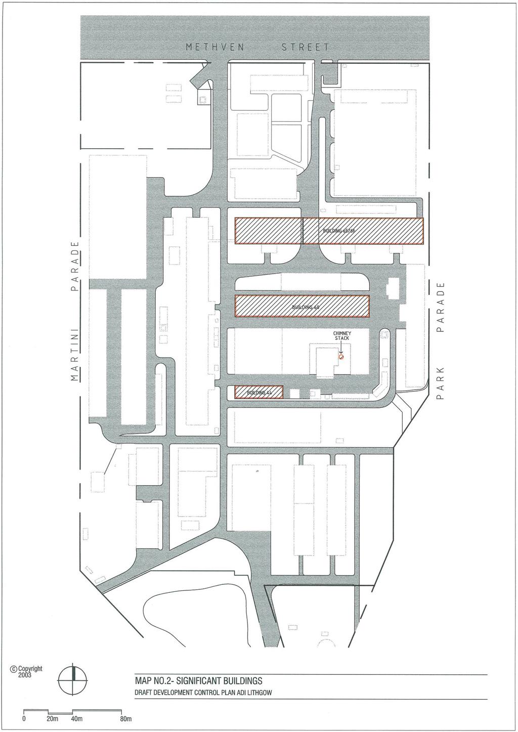
9 DRAFT DEVELOPMENT CONTROL PLAN ADI LIMITED SITE, LITHGOW 7 Contaminated soils, fill and waste disposal areas; Areas affected by land degradation i.e. erosion, salinity; Location and height of walls and fences built to the boundary; The built form and character of adjacent and nearby development, including characteristic fencing and landscaping styles; Archaeological and heritage sites; Use of adjoining land. A Site Analysis Plan must be to scale Controls (a) A detailed Site Analysis Plan is mandatory for all development and subdivision proposals with the exception of minor development such as alterations or changes of use. For minor development a simple plan showing key site characteristics and relationships with existing site features will be sufficient. (b) An explanatory statement must accompany the Site Analysis Plan outlining the principles and response to the Site Analysis Plan. The following is a list of sources to guide you in the preparation of a Site Analysis Plan:- Lithgow City Council Topographic maps, land capability maps, property descriptions, deposited plans, parish maps, heritage items. Department of Land & Water Conservation Ground water vulnerability, flood records, aerial photos, erosion and sediment control. Environment Protection Authority Contaminated land. Integral Energy, Telstra & AGL Electricity, Telephone and Natural Gas. 4.3 Heritage The site contains no Heritage Items as listed under Greater Lithgow Local Environmental Plan However, a heritage assessment of the site has identified a small number of buildings as having potential heritage significance (Significant Buildings) Objectives (1) To encourage the conservation or adaptive reuse where economically and structurally feasible of Significant Buildings, identified and shown on Map No.2 of this DCP Performance Criteria (1) All development proposals involving Significant Buildings need to be supported by a Heritage Impact Statement Requirements (1) The following buildings are identified as Significant Buildings. Refer to Map No. 2:- Building No 44; Building No 48 (chimney stack only); Building No 60; Building No 65/66. (2) Application for demolition or adaptive reuse of identified Significant Buildings, must be accompanied by a Heritage Impact Statement. The Statement is to provide comprehensive documentation and justification of the development proposal. All other applications for demolition of buildings or works are to
10 DRAFT DEVELOPMENT CONTROL PLAN ADI LIMITED SITE, LITHGOW 8 consider and assess the impact upon heritage values of the site (3) In assessing an application for demolition of a Significant Building
11 DRAFT DEVELOPMENT CONTROL PLAN ADI LIMITED SITE, LITHGOW 9 Council needs to take into consideration the following matters:- (1) The relative significance of the building. (2) The structural condition and adaptability of the building for modern manufacturing and high technology purposes. (3) The economic feasibility of retention and conservation of the building. (4) The impact of retention of the building on the proposed Industrial Park. 4.4 Building Design Objectives (1) To promote redevelopment or adaptive reuse of selected existing buildings which is functional, well designed, economically feasible and compatible with the local natural and built environment Performance Criteria (1) Building design Buildings are designed to integrate with the streetscape and be compatible with their surroundings. Adaptive reuse of Significant Buildings should respect and preserve as far as feasible their original forms and character. This is subject to economic feasibility, including all costs of demolition, rehabilitation and rebuilding. (2) Architectural interest The development is designed to contribute positively to the streetscape and provide architectural interest to both the industrial and surrounding residential areas. (3) Building height Building height is maintained at a scale appropriate to the location of the site and scale of the retained buildings. (4) Ancillary uses Ancillary uses are designed, constructed and located in a sympathetic manner which enhances the visual amenity of the development. Ancillary office space is designed to integrate with the industrial character and function of the site. (5) Security Building design facilitates surveillance of streets and open spaces. (6) Building materials The form, colours, textures and materials of buildings should enhance the quality and character of the site Requirements (1) Building design Facades adopt an appearance, appropriate to the function of the building. Adaptive reuse of Significant Buildings respects their original character and fabric. Where the side or rear elevation of a new industrial building is visible from residential areas, colours and wall profiles should be selected to minimise their visual impact. Other features which are encouraged include balustrades, pergolas, expressed structure and downpipes, glazed skylights, sun shading devices and distinctive entries. (2) Building height
12 DRAFT DEVELOPMENT CONTROL PLAN ADI LIMITED SITE, LITHGOW 10 New buildings should be generally compatible with the scale of existing buildings on the site. Building height does not adversely impact on the visual amenity of the locality or the City. Building height does not result in the loss of solar access to adjacent residential properties between the hours of 9.00am and 3.00pm on 22 June. (3) Ancillary uses Showroom display areas, offices, staff amenities and other low-scale building elements should be, wherever practicable, located adjacent to the entrance of the premises. The office component of the development is to be ancillary to the functions of the manufacturing process, warehouse or factory etc. (4) Security Buildings to address the street and open spaces where applicable to allow surveillance. (5) Building materials External walls and roofing materials of new buildings are to be of a nonreflective material, such as brick, concrete block, rendered concrete or masonry, metal or fibre cement cladding systems of Colourbond sheeting. All external building materials including roofing of new buildings shall be of a colour appropriate to the site. Mirror glass with a reflectivity in excess of 15% is not permitted. 4.5 Setbacks Objectives (1) To ensure that adequate area is available to accommodate landscaping and access to and around the site; (2) To reduce the visual impact of development on the streetscape; (3) To ensure there is emergency vehicle access at side boundaries Performance Criteria (1) Front/road setbacks Setbacks complement the streetscape and allow for landscaping and open space between buildings. (2) Side and rear setbacks Side and rear setbacks provide emergency services access and reduces adverse impacts on adjoining properties Requirements (1) New buildings are to be set back a minimum distance of 7m from Martini Parade, Methven Street, Park Parade and 5 metres from the road alignment of the internal roads. (2) On corner allotments buildings are set back a minimum distance of 3m from the boundary on the return frontage. (3) Buildings are set back a minimum distance of 3m from the side and rear boundaries. (4) The setback requirements do not apply to retained buildings. 4.6 Landscaping Objectives (1) To provide landscaping which contributes to the streetscape, enhances the amenity of the site and
13 DRAFT DEVELOPMENT CONTROL PLAN ADI LIMITED SITE, LITHGOW 11 preserve, where feasible, significant stands of trees or natural vegetation. (2) To improve the visual quality of industrial development and integrate the buildings with the natural landscape Performance Criteria (1) Site planning Landscaping is considered as a component of the site planning process and reflects the scale of development. (2) Existing trees and shrubs Development is designed to maximise the number of trees retained on site. (3) Visual amenity Landscaping is used to soften the impact of buildings, as a screen to visual intrusions, parking areas and for recreation space Requirements (1) Site planning Development proposals should be accompanied by a landscaping plan prepared by a qualified landscape architect, designer or other suitably qualified person, and is to show:- the main planting groups, any proposed plantings in verges and public open spaces, the location of fixed underground watering equipment, and provide a schedule of species, though indigenous species will be preferred. Upon approval of such a plan, landscaping is to be carried out prior to the occupation of the new building. (2) Existing trees and shrubs Where there are significant existing trees on-site, where possible the building design provides for their protection. During site work and construction, protective measures will be required around trees to be retained and the means to illustrate these measures will be required with the development application. (3) Visual amenity Landscaping is provided in front setback areas to soften the appearance of buildings and improve the streetscape. Landscaping includes species that will grow to a height consistent with the height and scale of the building. The following areas of the site shall be landscaped:- between the front boundary and the building(s), between the front lot boundary and building line; For developments facing a highway, a major local road, public open space or nearby residential area, trees with a mature height of at least 8 metres are to be planted. Trees except for shrubs must be 3m in height at planting. 4.7 Vehicular Access and Parking Objectives (1) To ensure vehicle access to and from a development is adequate, safe and direct;
14 DRAFT DEVELOPMENT CONTROL PLAN ADI LIMITED SITE, LITHGOW 12 (2) To provide sufficient, convenient and functional parking and loading/ unloading areas; (3) To provide for safe and environmentally compatible hard stand areas (4) To provide suitable access for vehicles to the site that does not unduly compromise residential amenity Performance Criteria (1) Ingress and egress Ingress and egress points are located and sized to facilitate the safe and efficient movement of vehicles to and from the site. Note: The design vehicle used to determine the width of the ingress, egress, driveways, accessways and manoeuvring areas is to be the largest vehicle likely to enter the site. (2) Accessways Accessways and driveways are sized to facilitate the safe and efficient movement of vehicles to, from and within the site (3) Carparking Carparking does not adversely impact upon the visual amenity of the site and the locality. Carparking is conveniently located and easily accessed. Carparking areas are designed to facilitate the safe movement of vehicles and provide a sufficient number of spaces for the projected needs of the development. (4) Loading/unloading and manoeuvring areas Facilities are provided on-site for the loading and unloading of goods. Manoeuvring areas are provided to ensure that the design vehicle can enter and leave the site in a forward direction. (5) Sealing and drainage All driveways, carparks, loading, unloading, manoeuvring areas etc are appropriately drained and sealed Requirements (1) Ingress and egress Vehicle access driveways are not within 6m of an intersection or break in a median strip. Ingress and egress points are signposted. Where separate ingress and egress points are proposed the ingress point is the first point reached when approaching the site by road from the side of the road upon which the development is located. Where a separate ingress and egress are provided they must be separated by a minimum distance of 3m. (2) Accessways Driveway widths are to be assessed on an individual lot basis. The widths are to be performance based. All internal accessways, manoeuvring areas etc are provided with directional signposting and linemarking, Access for heavy vehicles to be focussed on Methven and Martini Streets. Consideration of other access roads are to be subject to a traffic report assessing the impacts on the access
15 DRAFT DEVELOPMENT CONTROL PLAN ADI LIMITED SITE, LITHGOW 13 roads, including consideration of impacts on amenity All internal accessways are of a width and geometry to facilitate the safe and efficient movement of the design vehicle. All vehicles are able to enter and leave the site in a forward direction. Note: The above dimensions are minimum only. The width must be suitable given the turning path of the required design vehicle. (3) Carparking Visitor carparking is conveniently located to the main visitor entrance to the building, behind the building line. Carparking areas are designed in accordance with Lithgow City Council Development Control Plan for Off Street Parking of Motor Vehicles. The number of carparking spaces provided is in accordance with Lithgow City Council Development Control Plan for Off Street Parking of Motor Vehicles. (4) Loading/unloading and manoeuvring areas On-site loading and unloading areas are provided. Loading/unloading areas are designed and provided to facilitate their use by the design vehicle. Details of intended marking of entry and exit points, driveways, traffic flow, disabled parking, turning and unloading areas are required with the development application. (5) Sealing and drainage All areas are sealed in accordance with Lithgow City Council s Development Control Plan for Off Street Parking of Motor Vehicles. All sealed areas are drained to Council s stormwater system. No surface drainage is discharged across Council s footpaths or reserves. 4.8 Fencing Objectives (1) To minimise the visual impact of fencing on the locality. (2) To provide security to development on the site Performance Criteria Other than the specialised security requirements of ADI Limited, fencing and screen walls do not adversely impact upon the visual amenity of the area. Fencing provides adequate security for the ADI Limited establishment Requirements (1) General Industrial Development Solid fencing exceeding 1m in height is not provided forward of the front building line. Fencing does not exceed a maximum height of 1.8m, although higher security fencing may be provided where landscaping colour treatment of the fencing, or other suitable amelioration is provided to protect visual amenity. No fencing is provided within 3m of the front boundary. Fencing forward of the building line is incorporated with the landscaping, including earth mounds 600mm
16 DRAFT DEVELOPMENT CONTROL PLAN ADI LIMITED SITE, LITHGOW mm above natural ground level in order to reduce its visual impact. (2) ADI Limited site The height and type of fencing for the site will be provided to ensure security of the site commensurate with its function. 4.9 Design for Access and Mobility Objectives (1) To ensure that all developments, where appropriate, are designed and constructed to provide access and mobility for people with disabilities Performance Criteria (1) Developments are designed to satisfy relevant Australian Standards for access and mobility Requirements (1) Developments are designed in accordance with Australian Standard AS Design for Access and Mobility. (2) The Standard may be waived for development of existing Significant Buildings when it is demonstrated that compliance with the Standard would affect the integrity of the Building Waste Management Objectives (1) To provide for an efficient and environmentally responsible means of storage and/or disposal of waste and recyclable products Performance Criteria (1) Garbage The capacity, size, construction and placement of both trade waste and recyclables storage facilities are determined according to estimated amounts of waste and recyclables generated, safe means of collection, cleanliness and unobtrusive effects on the building and neighbourhood. Trade waste means liquid wastes discharged to the sewer and containing trade or factory wastes or chemical or other impurities from any business, trade or manufacturing premises other than domestic sewage, stormwater or unpolluted water. (2) Excavated material Excavated material, demolition and builders waste is disposed of in an environmentally sustainable manner Requirements (1) Garbage Trade waste and recyclables storage facilities are sized at a minimum area of 3m by 2.4m, located behind the building line, and capable of accommodating trade waste and recyclables generated by the premises together with associated handling equipment and providing sufficient space for loading and unloading. In addition to general sewerage rates and charges, the Council may levy trade waste, special rates and charges for acceptance of trade waste into the sewer and fix fees or charges for regulatory and other services in accordance with the revenue policy set out in the Council s management plan. Applicants wishing to discharge trade waste must enter into a Service Contract with the Council which will set out the conditions associated with the discharge of trade waste to the sewer.
17 DRAFT DEVELOPMENT CONTROL PLAN ADI LIMITED SITE, LITHGOW 15 (2) Excavated material Sites for disposal of excavated material, demolition and builders waste are to be nominated by the developer at the time of lodging the development application Soil and Water Quality, Noise Management Objectives (1) To minimise soil erosion and sedimentation by minimising land disturbance and requiring control measures at the source. (2) To retard the flow of water into the natural drainage system and mitigate impacts from stormwater runoff. (3) To protect the surrounding area from unnecessary noise Performance Criteria (1) Soil erosion Adequate provision is made for measures during construction to ensure that the land form is stabilised and erosion is controlled. The system design optimises the interception, retention and removal of water-borne pollutants through the uses of appropriate criteria, prior to their discharge to receiving waters. The system design minimises the environmental impact of urban runoff on surface receiving water quality and on other aspects of the natural environment, such as creek configuration and existing vegetation, by employing techniques which are appropriate and effective in reducing runoff and pollution travel. (2) Stormwater management Drainage from development sties is consistent with the pre-development stormwater patterns. Drainage systems should be designed to ensure safety and minimise stormwater inundation of habitable floor areas. (3) Noise management Other than the maintenance of existing ADI operational hours within their existing locations, the hours of operation of noise generating activities are restricted to avoid any noise nuisance upon surrounding residential areas. Developments are designed to minimise the potential for offensive noise to be generated. Noise control measures for any particular source should take account of all potentially affected points Requirements (1) Soil erosion An Erosion and Sediment Control Plan is prepared by properly qualified personnel using recognised and locally implemented hydrological, hydraulic, hydrogeological, soils water quality, biological data and design methodologies. The Erosion and Sediment Control Plan is to comply with the Department of Land and Water Conservations Managing Urban Stormwater Soils and Construction. Water pollution control ponds or wetlands are developed (where appropriate) for final treatment before discharge to the wider environment and should be sited to minimise impacts on the natural environment.
18 DRAFT DEVELOPMENT CONTROL PLAN ADI LIMITED SITE, LITHGOW 16 Development minimises earthworks (cut and fill). Where excavation works are intended to be undertaken development proposals are accompanied by:- a geotechnical report evaluating site stability; a schedule of earthworks; details of appropriate construction techniques. (2) Stormwater management The stormwater discharge for development sites does not exceed the 5 year ARI storm event. Typically, an on-site stormwater detention system will be required to reduce the volume of stormwater discharge. On-site stormwater and drainage control should be designed for the 20 year ARI storm. Trunk drainage systems should provide for the 20 year ARI event with overland flow paths designed for the 100 year storm ARI event. Stormwater should be gravity drained to Council s drainage system, which may require inter-allotment drainage. The habitable floor areas or dwellings constructed adjacent to trunk drainage systems, watercourses and creeks should be a minimum of 0.5m above the 100 year ARI flow level. (3) Noise management The hours of operation of activities in the development are between 7.00am and 6.00pm Monday to Friday and 8.00am to 4.00pm on Saturday, with no work to be undertaken on Sunday or Public Holidays. Council will consider applications outside these hours provided the activities to be undertaken at those times are designed to absolutely minimise the potential for offensive noise to be generated, especially to residential premises. Noise levels should not exceed the Recommended Background Planning Noise Level of 5dBa at the most affected point of the land use receiver area. Sources of noise such as garbage collection, machinery, parking areas and air conditioning plants should, where practicable, be sited away from adjoining properties and, where necessary, be screened by walls or other acoustical treatment. Note: These controls are applicable to new development on the site. The continued operation of the existing ADI Plant maintains existing operational rights Advertising Signs Objectives (1) To ensure advertising signs are compatible with the character and function of industrial development Performance Criteria (1) Role, function and location Advertising signs reflect the role and function of the industries. (2) Quantity and dimensions of signs The number and size of signs is limited to ensure equity for land uses and a pleasant visual environment Requirements (1) Role, function and location Signs are incorporated into the architecture of the building (ie located in recessed panels in the parapet or façade, or on purpose made structures including pylons, which relate to the style and materials of the building).
19 DRAFT DEVELOPMENT CONTROL PLAN ADI LIMITED SITE, LITHGOW 17 Advertising signs may only be erected where they are used in conjunction with a permissible use and situated on the land on which that use is conducted. (2) Quantity and dimensions of signs One freestanding advertising structure may be constructed within the front landscaped area of the site. Such structures should not exceed 2m 2 in area and 1.5m in height. One advertising structure may be placed on every façade which fronts a public road. Signs shall be no greater than 5m 2 in area and shall not be higher than the façade on which it is mounted. On multiple occupancy sites one index board may be constructed within the front landscaped area of the site. Such structures shall not exceed 2m 2 in area and 1.5m in height. One advertising sign may be placed on the façade of a unit and shall be no greater than 5m 2 in area and shall not be higher than the façade on which it is mounted Services Objectives (1) To ensure infrastructure has the capacity or can be adapted to accommodate new development; (2) To efficiently provide developments with appropriate physical services; and (3) To minimise the impact of increased stormwater runoff on drainage systems Performance Criteria (1) The development will not overload the capacity of public infrastructure, including reticulated services, streets, open space and human services. (2) The design and layout of development provides space (and easements where required) and facilities to enable efficient and cost-effective provision of reticulated services. (3) The development is connected to a reticulated sewerage, water supply and electricity system, and to gas where available. (4) Runoff control Stormwater drainage control measures could include:- constructing on-site stormwater detention with delayed release into the stormwater system; designing the site to minimise impervious areas; incorporating an onsite water recycling system; or a combination of the above. In areas where drainage infrastructure has little or no excess capacity, developments which would generate stormwater runoff beyond that equivalent to 35% site cover (or beyond that presently generated by the site if greater) should provide for stormwater drainage mitigation or upgrading of the local drainage system Requirements (1) The development is connected to Council s reticulated water supply stormwater drainage and sewerage system to Council s requirements (including separate water meters). (2) The development is connected to the Integral Energy reticulated electricity system to the authority s requirements.
20 DRAFT DEVELOPMENT CONTROL PLAN ADI LIMITED SITE, LITHGOW 18 (3) The development is connected to a telecommunication system to the appropriate authority s requirements.
21 DRAFT DEVELOPMENT CONTROL PLAN ADI LIMITED SITE, LITHGOW DEVELOPMENT CONTROLS SUBDIVISION (1) To ensure lots are designed to acknowledge site constraints and protect natural and cultural features. 5.1 Lot Size and Dimension Objectives (1) To provide reasonable site area for buildings, manoeuvring, carparking and landscaping. (2) To provide allotments of sufficient size to accommodate future potential uses. (3) To ensure that the site is not developed to a level which prevents its efficient operation Performance Criteria (1) Minimum lot size Lots are of an adequate size for the location of buildings, manoeuvring and parking of vehicles and landscaping. (2) Battle-axe lots Battle-axe lots have adequate access to and from the street Requirements (1) Minimum lot size Minimum lot size of 1500m 2 and 20 metre frontage. However, Council will allow flexibility of this control to encourage the provision of smaller lots as required. (2) Battle-axe lots Minimum areas and dimensions are as specified for each zone, with battleaxe handles a minimum width of 10m, and no longer than 50m. 5.2 Subdivision Design Objectives (2) To design subdivisions that are sustainable and contain allotments which are capable of meeting current and future demands for industrial land Performance Criteria (1) Natural and cultural features Lot layout acknowledges natural and cultural features such as archaeological sites, Significant Buildngs etc. (2) Site constraints Site constraints such as erosion and bushfire risk are acknowledged in subdivision design. (3) Special features Trees and views are retained through the careful layout of lots Requirements (1) Natural and cultural features Significant Buildings are included as features in the subdivision design. (2) Site constraints Subdivision pattern to respond to site constraints to maximise safety and efficiency. (3) Special features Stands of trees and individual specimens are designed as part of the subdivision. Lot layout allows future buildings to address any views.
22 DRAFT DEVELOPMENT CONTROL PLAN ADI LIMITED SITE, LITHGOW Open Space and Landscaping Objectives (1) To ensure subdivisions acknowledge public open space networks. (2) To provide street landscaping to assist in creating a microclimate and improving visual amenity of the site Performance Criteria (1) Public open space The multi-functional role of public open space, and its use as a community facility and for stormwater management, is recognised. (2) Street trees Street trees are selected and provided to assist in providing microclimate and improving streetscape amenity in the estate Requirements (1) Public open space Links from the development to public open space are provided to facilitate public access and stormwater management. Lots design encourages the siting of buildings in a position to face adjoining public open space. (2) Street trees Street trees are provided at the rate of 1 tree per 20m of street frontage where practicable. 5.4 Infrastructure Objectives (1) To ensure that the allotments are provided with essential services in a cost effective and timely manner Performance Criteria (1) Utilities Design and provision of utility services including sewerage, water, electricity, gas, street lighting and communication services are cost-effective over their life cycle and incorporate provisions to minimise adverse environmental impact in the short and long term. (2) Common trenching Compatible public utility services are located in common trenching in order to minimise the land required and the costs for underground services. (3) Availability of services Water supply and sewerage networks are available, accessible, easy to maintain, and cost-effective Requirements (1) Utilities The design and provision of new utility services conform to the requirements of the relevant service authorities. Water and sewerage services are to be provided to each allotment at the full cost of the developer. New water and sewerage services are to be designed and constructed in accordance with the requirements of Lithgow Council s Development and Subdivision Code. All utility services are designed, constructed and provided in accordance with the requirements of the appropriate authority. (2) Common trenching
23 DRAFT DEVELOPMENT CONTROL PLAN ADI LIMITED SITE, LITHGOW 21 Services are located in common trenches in accordance with the Plumbing and Drainage Code. Where possible electricity supply is to be underground. Speed reduction techniques are used to achieve desired speeds, as part of a design for the whole street environment. (3) Availability of services Council will not consent to the subdivision of any land until it is satisfied that an adequate water supply and adequate facilities for sewerage and drainage are available or until arrangements satisfactory to the Council have been made for the provision of such supply and facilities. 5.5 Road Hierarchy and Design Objectives To provide for streets that:- (1) Fulfil their designated functions within the street network; (2) Accommodate public utility services; (3) Accommodate drainage systems; and (4) Create a safe and attractive environment Performance Criteria (1) Function and width The street reserve width is sufficient to cater for all street functions, including safe and efficient movement of all users, including pedestrians and cyclists, provision for parked vehicles, provision for landscaping and location, construction and maintenance of public utilities. The verge width is sufficient to provide for special site conditions and future requirements. (2) Designing for safety The design facilitates safe use by pedestrians, particularly people with disabilities, the aged and children Requirements (1) Function and width Where possible, existing roads will be incorporated into the design of the redevelopment. Any new roads that may be required are to be designed and constructed in accordance with Lithgow Council s Development and Subdivision Code. New kerb ramps and footpath crossings are provided in accordance with AS Design Rules for Access by the Disabled. New verge width is increased where necessary to allow space for larger scale landscaping, indented parking, future carriageway widening, retaining walls, cycle paths or overland flow paths. (2) Designing for safety Providing a carriageway width which allows vehicles to proceed safely at the operating speed intended for that level of street. Making allowances for restrictions caused by on-street parking. Providing a horizontal and vertical alignment which is not conducive to excessive speeds. Promoting the safety of pedestrians at bus stops and other crossing points.
24 DRAFT DEVELOPMENT CONTROL PLAN ADI LIMITED SITE, LITHGOW 22 Promoting the safety of cyclists in streets and at crossing points. Slow points including either horizontal or vertical deflection are designed to slow traffic to design speeds. Slow points and carriageway narrowings are designed to take into account the needs of cyclists, by ensuring speed compatibility, adequate space for concurrent passage or off-street diversions. Landscape design, on-street parking and streetscape design are used to complement speed restriction measures. Speed restriction techniques and devices are not used in isolation. The verge provides safe sight distances, taking into account expected vehicle speeds and pedestrian and cyclist movement. Safe sight distances, based on vehicle travel speeds, exist at property access points, pedestrian and cyclist crossings and at junctions and intersections. Retain this sub clause 5.6 Stormwater Management Objectives Where possible the existing on site drainage system is to be utilised. However where new drainage is required it should:- (1) Adequately protect people and the natural and built environments to an acceptable level of risk and in a cost effective manner, in terms of initial cost and maintenance; and (2) Contribute positively to environmental enhancement of catchment areas Performance Criteria The stormwater drainage system has the capacity to safely convey stormwater flows resulting from the relevant design storm under normal operating conditions, taking partial minor system blockage into account. The stormwater system is designed to ensure that there are no flow paths which would increase risk to public safety and property. Drainage networks are well defined to ensure there are no hidden flow paths which could reduce their capacity to convey design flows. The system design allows for the safe passage of vehicles at reduced speed on streets which have been affected by runoff from the relevant design storm. Subdivision design and layout provides for adequate site drainage Requirements The design and construction of any new storm drainage system are in accordance with the requirements of Australian Rainfall and Runoff (1987) and Lithgow Council s Development and Subdivision Code. 5.7 Water Quality Management Objectives To provide water quality management systems which:- (1) Ensure that disturbance to natural stream systems is minimised; and (2) Ensure that stormwater discharge to surface and underground receiving waters, both during construction and in developing catchments, does not degrade the quality of water in the receiving areas.
25 DRAFT DEVELOPMENT CONTROL PLAN ADI LIMITED SITE, LITHGOW Performance Criteria Adequate provision is made for measures during construction to ensure that the land form is stabilised and erosion is controlled. The system design optimises the interception, retention and removal of water-borne pollutants through the use of appropriate devices, prior to their discharge to receiving waters. The system design minimises the environmental impact of urban runoff on surface receiving water quality and on other aspects of the natural environment, such as creek configuration and existing vegetation, by employing techniques which are appropriate and effective in reducing runoff and pollution travel Requirements An Erosion and Sediment Control Plan is prepared by properly qualified personnel using recognised and locally implemented hydrological, hydraulic, hydrogeological, soils, water quality and biological data and design methodologies. Water pollution control ponds or wetlands are developed (where appropriate) for final treatment before discharge to the wider environment and should be sited to minimise impacts on the natural environment.
26 DRAFT DEVELOPMENT CONTROL PLAN ADI LIMITED SITE, LITHGOW 1
27
28
4 Residential and Urban Living Zones
 4 Residential and Urban Living Zones Refer to Chapters 11 to 20 for additional rules that may apply to these zones. 4.1 OBJECTIVES AND POLICIES Objective Res1 Policy 1 Policy 2 Policy 3 Policy 4 Policy
SECTION 7A: WHAKARONGO RESIDENTIAL AREA
 SECTION 7A: WHAKARONGO RESIDENTIAL AREA CONTENTS 7A.1 Introduction 1 7A.2 Resource Management Issues 1 7A.3 Objectives and Policies 1 7A.4 Methods 4 7A.5 Residential Zone 4 7A.5.1 Rules: Controlled Activities
I615. Westgate Precinct
 I615. Westgate Precinct I615.1. Precinct Description The Westgate Precinct is located approximately 18km west of the Auckland city centre. There are seven Sub-precincts in the Westgate Precinct: Sub-precinct
MASTER PLAN NO. 60 (SITE DEVELOPMENT PLAN EASTBANK/REGATTA NORTH PRECINCTS 2 4) 2008
 2008") Page 2 TABLE OF CONTENTS PAGE 1 PRELIMINARY... 5 1.1 CITATION... 5 1.2 TYPE OF MASTER PLAN... 5 1.3 LEGAL REQUIREMENT FOR MASTER PLAN... 5 1.4 LEGAL EFFECT OF THE MASTER PLAN... 5 2 DESCRIPTION OF LAND...
Page 2 TABLE OF CONTENTS PAGE 1 PRELIMINARY... 5 1.1 CITATION... 5 1.2 TYPE OF MASTER PLAN... 5 1.3 LEGAL REQUIREMENT FOR MASTER PLAN... 5 1.4 LEGAL EFFECT OF THE MASTER PLAN... 5 2 DESCRIPTION OF LAND...
Sawtell Town Centre Development Control Plan
 Sawtell Town Centre Development Control Plan ABN 79 126 214 487 CONTENTS INTRODUCTION... 1 PREAMBLE... 1 HOW TO USE THIS DCP... 1 LAND TO WHICH THIS PLAN APPLIES... 1 MASTERPLAN... 2 VISION... 2 CHARACTER
Cape Cabarita (Formerly known as the Wellcome Site) Development Control Plan. Date of Adoption: 4 September 2007 Effective Date: 7 March 2008
 Development Control Plan. Date of Adoption: 4 September 2007 Effective Date: 7 March 2008") Cape Cabarita (Formerly known as the Wellcome Site) Development Control Plan Date of Adoption: 4 September 2007 Effective Date: 7 March 2008 Development Control Plan Index 1 INTRODUCTION...3 1.1 LAND TO
Cape Cabarita (Formerly known as the Wellcome Site) Development Control Plan Date of Adoption: 4 September 2007 Effective Date: 7 March 2008 Development Control Plan Index 1 INTRODUCTION...3 1.1 LAND TO
I602. Birdwood Precinct
 I602. Birdwood Precinct I602.1. Precinct description The Birdwood Precinct applies to an area west of Don Buck Road and south of Red Hills Road in west Auckland. It incorporates subdivision and development
Part 9 Specific Land Uses - Housing on Small and Narrow Lots
 19 HOUSING ON SMALL AND NARROW LOTS This section of the DCP applies where development for the purpose of a dwelling house, attached dwellings, or semi-detached dwellings is or are proposed in the R2 Low
QUEENSTOWN LAKES DISTRICT COUNCIL SUBDIVISION DESIGN GUIDELINES
 Attachment C: Draft QLDC Subdivision Design Guidelines QUEENSTOWN LAKES DISTRICT COUNCIL DESIGN GUIDELINES A DESIGN GUIDE FOR AND DEVELOPMENT IN THE URBAN ZONES QUEENSTOWN OFFICE 10 Gorge Road Queenstown
open space environment
 This section updated August 09 GUIDELINE TO THE RULES The Open Space Environment Rules apply to activities on sites within the Open Space Environment as shown on the Human Environments Maps. Most of the
AMENDMENTS. Date Effective. Amendment No. Council. DCP 14 Davidson St, Greenacre Page 2
 AMENDMENTS Amendment No. Description Adopted by Council Date Effective DCP 14 Davidson St, Greenacre Page 2 TABLE OF CONTENTS 1.0 INTRODUCTION... 4 1.1 NAME OF THIS PLAN... 4 1.2 COMMENCEMENT OF DEVELOPMENT
RURAL ZONE - POLICY. Rural Zone Policy. Issue: Rural Environment. Ruapehu District Plan Page 1 of 8
 Rural Zone Policy RU2 RURAL ZONE - POLICY RU2.1 Introduction The natural resources of the rural environment in the Ruapehu District provide the basis for the existing and potential character, intensity
ESSENTIAL ENGINEERING FOR PLANNERS
 ESSENTIAL ENGINEERING FOR PLANNERS Presented By Graham Coles, Urban Development Manager (Qld), Arcadis Australia Pacific 7 th March, 2017 Why Me? Biography A ground up background with over 17 years experience
Planning Proposal Charlestown Swim and Leisure Centre LEP Amendment
 Planning Proposal Charlestown Swim and Leisure Centre LEP Amendment Amendment No. 4 to Lake Macquarie Local Environmental Plan 2014 (PP_2014_LAKEM_005_00) Local Government Area: Name of Draft LEP: Lake
Development Control Plan
 Development Control Plan Rhodes Corporate Park (Also known as the Digital Site) Development Control Plan Date of Adoption: 4 September 2007 Effective Date: 7 March 2008 Index 1 INTRODUCTION... 3 1.1 LAND
Development Control Plan
 Development Control Plan Liberty Grove Development Control Plan Date of Adoption: 4 September 2007 Effective Date: 7 March 2008 Index 1 INTRODUCTION... 3 1.1 NAME OF PLAN... 3 1.2 AREA TO WHICH THIS PLAN
medium desnity housing
 This section updated September 2013 This part of the Plan sets out the assessment criteria for medium density housing. The criteria are designed to give designers and builders flexibility and to provide
MASTER PLAN NO. 62 (SITE DEVELOPMENT PLAN BIRTINYA VILLAGE CENTRE) 2009
 2009") Development Agreement, Development Control Plan 1 - Kawana Waters and Section 6.1.45A (Development Control Plans under Repealed Act) of the Integrated Planning Act 1997 MASTER PLAN NO. 62 (SITE DEVELOPMENT
Development Agreement, Development Control Plan 1 - Kawana Waters and Section 6.1.45A (Development Control Plans under Repealed Act) of the Integrated Planning Act 1997 MASTER PLAN NO. 62 (SITE DEVELOPMENT
I611. Swanson North Precinct
 I611. Swanson North Precinct I611.1. Precinct Description Swanson North is located in the north eastern foothills of the Waitakere Ranges. It is outside the Waitakere Ranges Heritage Area Act and the Waitakere
Wingecarribee Shire Council
 Connell Wagner Pty Ltd ABN 54 005 139 873 2 Palmer Street North Parramatta New South Wales 2151 Australia Telephone: +61 2 8896 4100 Facsimile: +61 2 9890 3558 Email: cwpar@conwag.com www.conwag.com Moss
I539. Smales 2 Precinct
 I539. Smales 2 Precinct I539.1. Precinct Description The Smales 2 Precinct applies to a 4.8 hectare block of land located on the southern side of Northcote Road and fronting Lake Pupuke, Takapuna. The
COMMUNITY DESIGN. GOAL: Create livable and attractive communities. Intent
 COMMUNITY DESIGN Intent An attractive, well-designed County will attract quality development, instill civic pride, improve the visual character of the community, and create a strong, positive image for
11.3 SPECIAL CHARACTER ZONE HAWKE S BAY REGIONAL SPORTS PARK
 11.3 SPECIAL CHARACTER ZONE HAWKE S BAY REGIONAL SPORTS PARK 11.3.1 INTRODUCTION The availability of sports and recreation activities and facilities is important for the maintenance and enhancement of
FORMER CANADIAN FORCES BASE (CFB) ROCKCLIFFE SECONDARY PLAN. Official Plan Amendment XX to the Official Plan for the City of Ottawa
 ROCKCLIFFE SECONDARY PLAN. Official Plan Amendment XX to the Official Plan for the City of Ottawa") FORMER CANADIAN FORCES BASE (CFB) ROCKCLIFFE SECONDARY PLAN Official Plan Amendment XX to the Official Plan for the City of Ottawa 1 INDEX THE STATEMENT OF COMPONENTS PART A THE PREAMBLE PAGE Purpose...
FORMER CANADIAN FORCES BASE (CFB) ROCKCLIFFE SECONDARY PLAN Official Plan Amendment XX to the Official Plan for the City of Ottawa 1 INDEX THE STATEMENT OF COMPONENTS PART A THE PREAMBLE PAGE Purpose...
Urban Stormwater: Best Practice Environmental Management Guidelines. CSIRO This electronic edition published by CSIRO PUBLISHING, 2006.
 Urban Stormwater: Best Practice Environmental Management Guidelines. Chapter 5 Water Sensitive Urban Design Key references Department of Planning, 1993, Better Drainage: Guidelines for the Multiple Use
Proposed Southland District Plan 2012 Appeal Version October 2016
 S e c t i o n 3. 5 - F i o r d l a n d / R a k i u r a Z o n e The Fiordland/Rakiura Zone encompasses the Fiordland and Rakiura National Parks and part of Mt Aspiring National Park. It also includes areas
Section 12B 12B Subdivision in Residential Zones
 Section 12B 12B Subdivision in Residential Zones The Residential Zones provide for a range of infill and greenfield living opportunities across the City for the community to accommodate current and future
6.6.2 Emerging Community Zone Code Application Purpose and overall outcomes. s6 Zone Codes Emerging Community and Township Zone Codes
 6.6.2 Emerging Community Zone Code 6.6.2.1 Application This code applies to assessable development:- (1) within the Emerging Community Zone as identified on the zoning maps contained within Schedule 2
NORTH EAST INDUSTRIAL ZONE
 SECTION 12A: NORTH EAST INDUSTRIAL ZONE CONTENTS 12A.1 Introduction 1 12A.2 Resource Management Issues 2 12A.3 Objectives and Policies 3 12A.4 Rules: Permitted Activities 8 R12A.4.1 Permitted Activities
15 Rural Residential Zone
 15 Rural Residential Zone Section 15A 15A Purpose of the Rural Residential Zone... 1 15A.1 Objectives and Policies of the Rural Residential Zone... 1 15A.2 Activity Status Rules... 5 15A.3 Permitted Activity
Section 12C Subdivision in the Rural Residential Zone
 Section 12C 12C Subdivision in the Rural Residential Zone The Rural Residential Zone provides part of the range of residential opportunities within the City. Land zoned rural residential is considered
Division 13 Local Business and Industry Buffer Zone: Assessment Criteria and Assessment Tables
 Division 13 Local Business and Industry Buffer Zone: Assessment Criteria and Assessment Tables 4.13.1 Local Business and Industry Buffer Zone The provisions in this division relate to the Local Business
Kaufland supermarket and complementary uses, part 1550 Pascoe Vale Road, Coolaroo Incorporated Document (Insert date) 2019
 2019") Kaufland supermarket and complementary uses, part 1550 Pascoe Vale Road, Coolaroo Incorporated Document (Insert date) 2019 Page 1 of 7 Incorporated document pursuant to section 6(2)(j) of the Planning
Kaufland supermarket and complementary uses, part 1550 Pascoe Vale Road, Coolaroo Incorporated Document (Insert date) 2019 Page 1 of 7 Incorporated document pursuant to section 6(2)(j) of the Planning
Water Sensitive Urban Design Site Development Guidelines and Practice Notes. Appendix
 Water Sensitive Urban Design Site Development Guidelines and Practice Notes Appendix 108 Appendix A Water sensitive developments involve simple design and management practices that take natural site features
4 RESIDENTIAL ZONE. 4.1 Background
 4 RESIDENTIAL ZONE 4.1 Background The residential areas within the City are characterised by mainly lowrise dwellings sited on individual allotments. Past architectural styles, settlement patterns and
Planning Proposal Concurrent DA/LEP Amendment for Belmont North Pharmacy Amendment No. 24 to Lake Macquarie Local Environmental Plan (LMLEP) 2014
 2014") Planning Proposal Concurrent DA/LEP Amendment for Belmont North Pharmacy Amendment No. 24 to Lake Macquarie Local Environmental Plan (LMLEP) 2014 Local Government Area: Name of Draft LEP: Subject Land:
Planning Proposal Concurrent DA/LEP Amendment for Belmont North Pharmacy Amendment No. 24 to Lake Macquarie Local Environmental Plan (LMLEP) 2014 Local Government Area: Name of Draft LEP: Subject Land:
Draft Ada Street Cardiff Area Plan
 Draft Ada Street Cardiff Area Plan (Draft Amendment to Lake Macquarie Development Control Plan 2014) Exhibition: The draft Area Plan is on public exhibition from 29 February 2016 to 29 March 2016. Submissions:
Appendix 1 Structure plan guidelines
 Appendix 1 Structure plan guidelines This appendix forms part of the regional policy statement [rps]. 1.1. Introduction Structure plans are an important method for establishing the pattern of land use
statement of environmental effects
 for single dwelling houses, granny flats and associated ancillary structures only property details Please provide the following details Lot N o/s. Section N o. DP N o. A statement of environmental effects
Design and siting guidelines
 Design and siting guidelines Enhance your lifestyle Callaway Park an development 1 These Guidelines deal with the planning and development of the vacant residential land lots at Callaway Park. 2 Introduction
Division 5 Reconfiguring a Lot Code
 Division 5 Reconfiguring a Lot Code 12.5.1 Reconfiguring a Lot Code The provisions in this division comprise the Reconfiguring a Lot Code. They are compliance with the Reconfiguring a Lot Code (section
22.15 OUTDOOR ADVERTISING SIGNAGE POLICY
 22.15 OUTDOOR ADVERTISING SIGNAGE POLICY This policy applies to all land where a planning permit is required to construct or display a sign under the provisions of the Kingston Planning Scheme. 22.15-1
Part 12 Precinct Area Plans - Wyee West
 TABLE OF CONTENTS 1 INTRODUCTION... 1 1.1 BACKGROUND... 1 1.2 EXTENT OF AREA PLAN... 1 1.3 EXISTING CHARACTER... 2 1.4 ENVIRONMENTAL ATTRIBUTES AND CONSTRAINTS... 2 1.5 DESIRED FUTURE CHARACTER... 3 1.6
Division 7 Character Areas Housing Zone: Assessment Criteria and Assessment Tables
 Division 7 Character Areas Housing Zone: Assessment Criteria and Assessment Tables 4.7.1 Character Areas Housing Zone The provisions in this division relate to the Character Areas Housing Zone as follows
Authority. any changes required as a result of the approved CHMP.
 PLANNING PERMIT Permit No. Planning Scheme Responsible Authority../2013 Greater Geelong Planning Scheme Greater Geelong City Council ADDRESS OF THE LAND 5, 15, 21, 23, 1/23, 25, 33, 40 and 50 Caddys Road;
Planning Proposal Toronto Road, Booragul. Amendment to Lake Macquarie Local Environmental Plan (LMLEP) 2014
 2014") Planning Proposal Toronto Road, Booragul Amendment to Lake Macquarie Local Environmental Plan (LMLEP) 2014 Local Government Area: Name of Draft LEP: Subject Land: Land Owner: Applicant: Folder Number:
Planning Proposal Toronto Road, Booragul Amendment to Lake Macquarie Local Environmental Plan (LMLEP) 2014 Local Government Area: Name of Draft LEP: Subject Land: Land Owner: Applicant: Folder Number:
OFFICE CONSOLIDATION SECONDARY PLAN AREA 22 THE BRAMALEA SOUTH INDUSTRIAL SECONDARY PLAN
 OFFICE CONSOLIDATION SECONDARY PLAN AREA 22 THE BRAMALEA SOUTH INDUSTRIAL SECONDARY PLAN November 2010 EXPLANATORY NOTES (Secondary Plan Area 22) General (pertaining to all secondary plan office consolidations)
When planning stormwater management facilities, the following principles shall be applied where possible.
 2.0 Principles When planning stormwater management facilities, the following principles shall be applied where possible. 2.0.1 Drainage is a regional phenomenon that does not respect the boundaries between
Lake Macquarie City. A copy of the published amendment including the instrument and maps, is provided in Attachment 7 of this report.
 Planning Proposal Amendment No. 77 to Lake Macquarie Local Environmental Plan 2004 and proposed Amendment to Draft Lake Macquarie Local Environmental Plan 2013 Minor Zone Boundary Adjustment - Pasminco
List of Policies. SESPlan. None applicable. Consolidated Scottish Borders Local Plan 2011: POLICY G1 - QUALITY STANDARDS FOR NEW DEVELOPMENT
 List of Policies Local Review Reference: 15/00021/RREF Planning Application Reference: 15/00616/FUL Development Proposal: Installation of 16no solar photovoltaic (PV) panels to roof Location: Raebank,
Part 4.25 Pasminco Area Plan
 1 INTRODUCTION The purpose of this Area Plan is to guide the redevelopment of the former Pasminco Cockle Creek Smelter site and the former Incitec Pivot Fertilizer site. The Pasminco and Incitec sites
Tāhuhu whakaruruhau ā-taone The sheltering ridge pole
 B2. Tāhuhu whakaruruhau ā-taone - Urban growth and form B2.1. Issues Tāhuhu whakaruruhau ā-taone The sheltering ridge pole Auckland s growing population increases demand for housing, employment, business,
DRAFT Northeast Quadrant of Kipling Avenue and Highway 7 DRAFT AUGUST 29, Goals Land Use. The goals of this Plan are to:
 AUGUST 29, 2017 12.15 Northeast Quadrant of Kipling Avenue and Highway 7 12.15.1 Goals 12.15.2 Land Use The goals of this Plan are to: 12.15.2.1 General Provisions: a) Ensure the development of a compact
Department of Planning
 NSW GOVERNMENT Department of Planning Contact: Sumathi Navaratnam Phone: 02 9228 6361 Fax: 02 9228 6540 E-mail: sumathi.navaratnam@planning.nsw.gov.au Mr Robert Domm Chief Executive Officer Redfern - Waterloo
I403 Beachlands 1 Precinct
 I403. Beachlands 1 I403.1. Precinct Description Beachlands is a rural and coastal village located on the eastern side of Auckland, adjoining the Tamaki Strait coastline. The original Beachlands village
I404 Beachlands 2 Precinct
 I404. Beachlands 2 I404.1. Precinct Description The Beachlands 2 precinct covers approximately 6 hectares of land at the corner of Beachlands and Whitford Maraetai Roads. Its purpose is to provide for
AOTEA SUPERMARKET ZONE. Zone Introduction
 C18 AOTEA SUPERMARKET ZONE Zone Introduction C18.1 Objective This zone identifies a specific area in Aotea for a stand alone supermarket. The zone is site specific and has a range of objectives, policies
CHAPTER 13 DESIGN GUIDELINES
 CHAPTER 13 DESIGN GUIDELINES Section 1300.00 Section 1300.01 Design Guidelines Purpose The purposes of this section are to: A. The purpose of this Section is to establish procedures and standards to serve
SECTION ONE North East Industrial Zone Design Guide Palmerston North City Council June 2004
 SECTION ONE North East Industrial Zone Design Guide Palmerston North City Council June 2004 young heart easy living 1 Preface Industrial areas are a very important component of the economic well-being
I609. Penihana North Precinct
 I609. Penihana North Precinct I609.1. Precinct description The Penihana North Precinct is located south of the Swanson Railway Station, adjacent to the Rural Urban Boundary (RUB) and Waitakere Ranges Heritage
Lake Macquarie Development Control Plan 2014 Revision 19
 Lake Macquarie Development Control Plan 2014 Revision 19 Part 8 Subdivision Development Adopted by Council 25 June 218 Page 0 F2018/00436 TABLE OF CONTENTS: 1 INTRODUCTION... 4 1.1 HOW TO USE THIS PLAN...
Wingecarribee Shire Council
 Connell Wagner Pty Ltd ABN 54 005 139 873 2 Palmer Street North Parramatta New South Wales 2151 Australia Telephone: +61 2 8896 4100 Facsimile: +61 2 9890 3558 Email: cwpar@conwag.com www.conwag.com Moss
1. Assessment of Environmental Effects
 1. Assessment of Environmental Effects Table of Contents 1. Introduction and Overview 1 2. Statutory Assessment 3 3. Site Description 5 4. Proposal Description 7 5. Assessment of Effects on the Environment
64 Mineral Extraction Area Rules
 64 Mineral Extraction Area Rules 64.1 Introduction For the purposes of this Chapter: Active Area, in relation to a Mineral Extraction Area (MEA), is that part of the Mineral Extraction Area which is owned
SCHEDULE 10 TO THE URBAN GROWTH ZONE. Shown on the planning scheme map as UGZ10. Truganina Precinct Structure Plan. 1.0 The Plan
 SCHEDULE 10 TO THE URBAN GROWTH ZONE Shown on the planning scheme map as UGZ10 Truganina Precinct Structure Plan 1.0 The Plan Map 1 shows the future urban structure proposed in the Truganina Precinct Structure
Plan Modification to Chapter B2 of the Auckland Unitary Plan(AUP) Operative in part (15 November 2016)
 Operative in part (15 November 2016)") UNITARY PLAN UPDATE REQUEST MEMORANDUM TO FROM Phill Reid Linley Wilkinson DATE 25 September 2018 SUBJECT Plan Modification to Chapter B2 of the Auckland Unitary Plan(AUP) Operative in part (15 November
UNITARY PLAN UPDATE REQUEST MEMORANDUM TO FROM Phill Reid Linley Wilkinson DATE 25 September 2018 SUBJECT Plan Modification to Chapter B2 of the Auckland Unitary Plan(AUP) Operative in part (15 November
THREE PARKS ZONE Three Parks Special Zone The process of applying for resource consents in the zone.
 .25 Three Parks Special Zone The purpose of this zone is to provide for growth and to give effect to the Wanaka 2020 Community (2002) and the more recent Wanaka Structure (2007) and Wanaka Transport Strategy
Section Three, Appendix 16C Medium Density Housing, Design Assessment Criteria (Residential 8A zone)
") APPENDIX 16C MEDIUM DENSITY HOUSING, DESIGN ASSESSMENT CRITERIA (RESIDENTIAL 8A ZONE) PURPOSE OF APPENDIX 16C (RESIDENTIAL 8A ZONE) In the Residential 8A Zone the following are defined as restricted discretionary
APPENDIX 16C MEDIUM DENSITY HOUSING, DESIGN ASSESSMENT CRITERIA (RESIDENTIAL 8A ZONE) PURPOSE OF APPENDIX 16C (RESIDENTIAL 8A ZONE) In the Residential 8A Zone the following are defined as restricted discretionary
RESIDENTIAL ACTIVITY PERFORMANCE STANDARDS
 Preferred Options Consultation Q&A Sheet RESIDENTIAL ACTIVITY PERFORMANCE STANDARDS What are the key goals for managing the design of residential buildings in the Second Generation Plan (2GP)? The key
RLE.1 Rural Living Environment
 Index.1 Description and Expectations.2 Objectives.3 Policies.4 Guidance RLE.2 Landuse RLE.2.1 Eligibility Rules RLE.2.2 Notification Rules RLE.2.3 Discretionary Activities RLE.3 Subdivision RLE.3.1 Eligibility
Lake Macquarie Development Control Plan Revision 20
 Lake Macquarie Development Control Plan 2014 - Revision 20 LMCC DCP 2014 Revision 20 Page 0 F2016/01470 TABLE OF CONTENTS: 1 INTRODUCTION... 3 1.1 HOW TO USE THIS PLAN... 3 1.2 ADDITIONAL CONTROLS FOR
12 Subdivision, Services and Infrastructure
 12 Subdivision, Services and Infrastructure Section 12A 12A Purpose of Subdivision Provisions... 1 12A.1 General Subdivision Objectives and Policies... 2 12A.2 Activity Status Rules... 4 12A.3 General
Chapter 13 Residential Areas: Appendices APPENDIX 1 Residential Areas
 Chapter 13 Residential Areas: Appendices Page 1 Chapter 13 Residential Areas: Appendices APPENDIX 1 Residential Areas Design Code for Intensive Housing INTRODUCTION DESIGN ELEMENTS A NEIGHBOURHOOD DESIGN
Development Control Plan
 Development Control Plan Abbotsford Cove (Also known as the Former Nestle Site) Development Control Plan Date of Adoption: 4 September 2007 Effective Date: 7 March 2008 Index 1 INTRODUCTION... 3 1.1 ENVIRONMENTAL
PLANNING INSTITUTE OF AUSTRALIA, NSW DIVISION SUBMISSION ON THE NSW DRAFT HOUSING CODE AND NSW DRAFT COMMERCIAL CODE
 PLANNING INSTITUTE OF AUSTRALIA, NSW DIVISION SUBMISSION ON THE NSW DRAFT HOUSING CODE AND NSW DRAFT COMMERCIAL CODE This Submission provides detailed comment on draft Codes following feedback from PIA
APPENDIX 10 THE RESIDENTIAL DESIGN GUIDE FOR DEVELOPMENTS IN RESIDENTIAL ZONES IN SPECIFIED GROWTH AREAS
 THE RESIDENTIAL DESIGN GUIDE FOR DEVELOPMENTS IN RESIDENTIAL ZONES IN SPECIFIED GROWTH AREAS ISTHMUS SECTION - OPERATIVE 1999 Page 1 CONTENTS... PAGE 1.0 INTRODUCTION... 4 1.1 Growth Management Strategy...
PLANNING COMMITTEE REPORT
 PLANNING COMMITTEE REPORT TO: BY: Planning Committee South Head of Development DATE: 19 December 2017 DEVELOPMENT: SITE: WARD: APPLICATION: APPLICANT: Conversion of existing water storage reservoir to
PLANNING DECISION NOTICE
 PLANNING DECISION NOTICE TOWN AND COUNTRY PLANNING ACT, 1990 Applicant WILLITON VILLAGE HALL STEERING COMM. C/O ALISON CALLOWWAY 54 NORTHCROFT WILLITON TAUNTON TA4 4RT Date Registered 11/08/2006 Application
Subdivision Design Criteria. Penihana North GUIDELINES TO THE RULES
 Created September 2013 Penihana North Subdivision Design Criteria GUIDELINES TO THE RULES This part of the Plan sets out the design criteria for subdivision in Penihana North. The criteria will be considered
ARTICLE 17 SITE PLAN REVIEW
 ARTICLE 17 SITE PLAN REVIEW 17.01 INTENT AND PURPOSE The intent of this section is to provide for consultation and cooperation between the applicant and the township planning commission so that the applicant
Advisory notes. Design and siting of buildings and structures. Purpose of these notes. Building setbacks and site coverage.
 Advisory notes Design and siting of buildings and structures Purpose of these notes The design and siting of buildings and structures within the City of Gold Coast (the City) is regulated by a combination
SCHEDULE THREE TO THE DEVELOPMENT PLAN OVERLAY EASTERN GOLF COURSE KEY REDEVELOPMENT SITE
 DD/MM/YY SCHEDULE THREE TO THE DEVELOPMENT PLAN OVERLAY Shown on the planning scheme map as DPO3 EASTERN GOLF COURSE KEY REDEVELOPMENT SITE 1.0 A permit may be granted before a development plan has been
Hurstville DCP No. 1 (Amendment No.5) Table of Contents
 Table of Contents") Hurstville DCP No. 1 (Amendment No.5) Section Table of Contents 1.0 Introduction 1 2.0 Application Process 2.1 Exempt and Complying Development 15 2.2 Neighbour Notification and Advertising of Development
Hurstville DCP No. 1 (Amendment No.5) Section Table of Contents 1.0 Introduction 1 2.0 Application Process 2.1 Exempt and Complying Development 15 2.2 Neighbour Notification and Advertising of Development
DEVELOPMENT APPLICATION DECISION NOTICE Sustainable Planning Act 2009 (SPA)
") Date >> 06 July TOWNSVILLE CITY COUNCIL LEVEL 1 GOLD FOYER 143 WALKER STREET PO BOX 1268, TOWNSVILLE QUEENSLAND 4810 Ross River Solar Farm Pty Ltd C/- AECOM Australia Pty Ltd PO Box 5423 TOWNSVILLE QLD
Date >> 06 July TOWNSVILLE CITY COUNCIL LEVEL 1 GOLD FOYER 143 WALKER STREET PO BOX 1268, TOWNSVILLE QUEENSLAND 4810 Ross River Solar Farm Pty Ltd C/- AECOM Australia Pty Ltd PO Box 5423 TOWNSVILLE QLD
Lake Macquarie Development Control Plan 2014 Revision 20
 Lake Macquarie Development Control Plan 2014 Revision 20 TABLE OF CONTENTS: 1 INTRODUCTION... 3 1.1 HOW TO USE THIS PLAN... 3 1.2 ADDITIONAL CONTROLS FOR SPECIFIC LAND USES... 3 1.3 AIMS FOR DEVELOPMENT
Development Permit Application Form. Property Owner Information as Registered on Legal Title Property Owner Name: Phone:
 Development Application Requirements 1 1926 Tsawwassen Drive Tel: 604-943-2112 Tsawwassen, BC V4M 4G2 www.tsawwassenfirstnation.com Canada Development Permit Application Form Name of Applicant: Address:
I422. Māngere Gateway Precinct
 I422. Māngere Gateway Precinct I422.1. Precinct description The Māngere Gateway Precinct is comprised of land generally north of the Auckland International Airport and west of George Bolt Memorial Drive
APPENDIX MATAKANA COMMERCIAL URBAN DESIGN GUIDELINES
 APPENDIX MATAKANA COMMERCIAL URBAN DESIGN GUIDELINES 1.0 INTRODUCTION The following urban design guidelines are to be utilised by landowners, planners and other persons involved in development at early
Section 6A 6A Purpose of the Natural Features and Landscapes Provisions
 Section 6A 6A Purpose of the Natural Features and Landscapes Provisions This Chapter addresses the protection and management of natural features and landscapes within the City. The City has a number of
Private Tennis Courts
 Private Tennis Courts Sutherland Shire Council 9.2/03 edition 3 Contents 1. Where does the Plan apply? 2. What is the purpose of the Plan? 3. Can the Plan be varied? 4. Making an application 5. Site and
Subdivision and Development
 Subdivision and Development 8.0 Introduction - Subdivision and Development The principle purpose of subdivision is to provide a framework for land ownership so that development and activities can take
4.3 Dudley Area Plan. Introduction. History and Existing Character. Desired Future Character for Dudley
 4.3 Dudley Area Plan Introduction The suburb of Dudley has developed as a result of various circumstances including its topography, history and mineral resources. Dudley development has been identified
SECTION 2.4 URBAN DEVELOPMENT AND STRATEGIC URBAN DIRECTIONS
 SECTION 2.4 URBAN DEVELOPMENT AND STRATEGIC URBAN DIRECTIONS 2.4.1 INTRODUCTION In 1993/94 the Hastings District Council completed the Hastings Urban Development Strategy. The purpose of this study was:
Rural (Urban Expansion) Environment
 Environment") RUEE.1 Rural (Urban Expansion) Environment Index RUEE.1 RUEE.1.1 RUEE.1.2 RUEE.1.3 RUEE.1.4 RUEE.2 RUEE.2.1 RUEE.2.2 RUEE.2.3 RUEE.2.4 RUEE.3 Rural (Urban Expansion) Environment Description and Expectations
RUEE.1 Rural (Urban Expansion) Environment Index RUEE.1 RUEE.1.1 RUEE.1.2 RUEE.1.3 RUEE.1.4 RUEE.2 RUEE.2.1 RUEE.2.2 RUEE.2.3 RUEE.2.4 RUEE.3 Rural (Urban Expansion) Environment Description and Expectations
Highway Oriented Commercial Development Criteria
 7.6 HOC-1 Highway Oriented Commercial District A. Statement of Purpose The Highway Oriented Commercial District (HOC-1) is intended to provide for the development of high density retail and service businesses
The Proposed Auckland Unitary Plan (notified 30 September 2013)
") 3 Business zones Introduction There are 10 business zones in the Unitary Plan: City Centre Metropolitan Centre Town Centre Local Centre Neighbourhood Centre Mixed Use General Business Business Park Light
3 Business zones Introduction There are 10 business zones in the Unitary Plan: City Centre Metropolitan Centre Town Centre Local Centre Neighbourhood Centre Mixed Use General Business Business Park Light
Lake Macquarie Development Control Plan 2014 Revision 17
 Lake Macquarie Development Control Plan 2014 Revision 17 Part 3 Development within Residential Zones Draft LMCC DCP 2014 Page 1 F2009/00952 Version 4 Exhibition Draft July 2012 TABLE OF CONTENTS: 1 INTRODUCTION...
18 Industrial Zones. Section 18A. Appendices
 18 Industrial Zones Section 18A 18A Purpose of the Industrial Zones... 1 18A.1 Purpose of the Industry Zone... 1 18A.2 Purpose of the Port Industry Zone... 1 18A.3 Purpose of the Tauriko Industry Zone...
Schedule of Planning Applications Committee Date: 23 May Reference: 06/17/0726/F Parish: Hemsby Officer: Mr J Beck Expiry Date:
 Schedule of Planning Applications Committee Date: 23 May 2018 Reference: 06/17/0726/F Parish: Hemsby Officer: Mr J Beck Expiry Date: 22-05-2018 Applicant: Proposal: Site: Mr Gillett Change of use to the
10 Proposed Redevelopment, Tewkesbury Road, Cheltenham SCHEME EVOLUTION STARBUCKS
 SCHEME EVOLUTION STARBUCKS The proposed Starbucks Drive Thru alongside the proposed food store provides an appropriate mix of uses, suitable for this location. The proposed store is bespoke, designed specifically