ESSENTIAL ENGINEERING FOR PLANNERS
|
|
|
- Allyson Walters
- 6 years ago
- Views:
Transcription
1 ESSENTIAL ENGINEERING FOR PLANNERS Presented By Graham Coles, Urban Development Manager (Qld), Arcadis Australia Pacific 7 th March, 2017
2 Why Me? Biography A ground up background with over 17 years experience in shaping the form of Urban Green Field Developments and optimizing Infill Brown Field Developments Project involvement from Pre-purchase Due Diligence Investigations and Financing Assessments through construction to Project completion Successfully delivered Single stage through to Multi-Stage and Multi-Use Master Planned Communities within all of the SEQ Region Local Authorities. Currently manage a team of +45 staff in our Brisbane and Gold Coast offices and responsible for the mentoring of all levels of engineering staff to understand the principles of sustainable engineering design as part working within the Bigger Picture. 07 March

3 Target Session Outcomes Improve on your understanding of the fundamentals of engineering in a site due diligence investigations process Be able to relate these fundamentals into early concept planning of developments at varying levels of scale and location Take your existing understanding of authority overlay mapping and be able to apply these with context Improve on your ability to identify site constraints, identify how to respond to them and maximize the development potential of each site Have an understanding of common engineering acronyms 07 March

4 What is Essential and Why? Macro Engineering Design Elements that, At a Community Level Elements that impact on the Urban Design or Structure Plan of a Community, At a Site and Allotment Level Elements that impact on the Development Footprint, Outer Boundary and Road/Allotment Orientation. Demonstrate Compliance with the relevant State and Local Authority Statutory town planning requirements 07 March

5 Critical Engineering Design Elements Due Diligence Considerations & Site Constraint Mapping How will the development access Essential Infrastructure Road Access A Lawful Point of Discharge for site storm water runoff A point of discharge for site Sewer Reticulation Access to Potable Water Supply, at the right pressure Access to Electrical and Communications services How will the development respond to Site Constraints Flood & Storm Water Management Site grade impacts on allotment benching and retaining Integration of Public Spaces into the community movements 07 March
6 Essential Infrastructure Access to Road Network Road Hierarchy Understand Road Hierarchy planning to differentiate trunk roads that are used to move residents through a community as opposed to estate roads which function to provide access to each allotment. Be aware that the road corridor width and the internal pavement widths will vary with each level of the hierarchy. Traffic Planning engineers will typically provide the advice on the suitable hierarchy of the roads within larger greenfield estates based on traffic counts. Direct allotment access vs non-direct allotment access Access Places through to Collector Streets provide direct allotment access with the road pavement and corridor widths increasing to cater for on street parking and wider verges for pedestrian and cyclist paths as traffic volumes and catchments increase. Major Collector and Sub-Arterial Roads are typically inter suburb roads and direct allotment access is generally not permitted. These roads are typified by high traffic volumes and often higher speed environments. Identified Bus Routes will often require a specific road corridor design to cater for indented bus stops and turning maneuvers. 07 March
7 07 March
8 Essential Infrastructure Access to Road Network Safe Intersection Design Critical to the location of road intersections for new estate entry roads and major internal intersections in greenfield developments is the consideration of Sight Distance and Pedestrian/Cyclist movement. All intersections need to be designed to ensure that they achieve the AUSTRoads requirements for Safe Intersection Sight Distance (SISD) and Approach Sight Distance (ASD) Pedestrian & Cyclist Movement Determine if the hierarchy of the road makes provision for on-road or in verge cycle movement as this will inform your urban design linkages between parks and open spaces with the proposed allotments. Consider the context of the actual development against the standards and challenge how the requirement can be achieved but in a more sustainable outcome. 07 March
9 Essential Infrastructure 07 March
10 Essential Infrastructure Lawful Point of Discharge There is no prescribed legal meaning but The Queensland Urban Drainage Manual (QUDM) defines a two part test to determine if a development achieves this requirement, 1. The location of the discharge is under the lawful control of the local government or other statutory authority from whom permission to discharge has been received. This will include park, drainage or road reserve or a stormwater drainage easement. 2. In discharging to that location, the discharge will not cause an actionable nuisance (i.e. a nuisance for which the current or some future neighbouring proprietor may bring an action or claim for damages arising out of the nuisance), or environmental or property damage. How will the development receive storm water runoff from upstream adjoining properties without changing the way in which it leaves, i.e. does not cause ponding or constriction that results in extended inundation. Can the pipe drainage achieve an outlet to the ground surface or connect to an existing pipe system and will it leave the site in the same regime as it did in the predevelopment case. How will bulk earthworks cut and fill, road pavements and onsite overland flow paths change the site flows 07 March

11 07 March
12 Essential Infrastructure Sewer Reticulation Design and Discharge Where is the closest gravity discharge option to the site Request a Services Advice Notice (SAN) or equivalent from the Water Authority to identify site servicing and infrastructure planning issues. Check the path of the connecting sewer to determine if it needs to cross gullies, pass through steep ridges or traverse private property. If there is a significant separation between the site and the existing sewer and is there any Trunk Infrastructure planned in or around the site? Water Retail Authorities such as Queensland Urban Utilities, Unity Water and then Logan Water, Redland Water and Gold Coast Water have Priority Infrastructure Plans (PIP s) that identify the location of planned infrastructure. Typically Trunk Sewer is categorized as 300mm diameter, however occasionally 225/250mm diameter can apply 07 March
13 Essential Infrastructure Sewer Reticulation Design and Discharge What options are available? Conventional Gravity connection with a pipe size of 150mm/160mm diameter that can achieve minimum cover Private / Temporary or PIP Sewer Pump Station (SPS) and Rising Main Low Pressure Sewer and external Rising Main Implications of system on extent of development Will a conventional gravity system restrict how much of the site can be serviced. Will an Odour Control Unit on the SPS vent pole reduce the development setback requirement (100m radius) Will the market accept a non conventional sewer system and the additional costs to the buyer for a Low Pressure Sewer System. 07 March

14 07 March
15 Essential Infrastructure Water Reticulation Connection Where is the closest connection option to the site Request a Services Advice Notice (SAN) or equivalent from the Water Authority to identify site servicing and infrastructure planning issues. Check the path of the connecting water main to determine if there is available service corridors in the road verge. Will the development scale and location require a network assessment be completed to determine if the Desired Level of Service criteria can be achieved for Fire Flow (25L/s) and minimum mains pressure of 15m Head and maximum of 80m Head? If there is a significant separation between the site and the existing water, is there any Trunk Infrastructure planned in or around the site? Water Retail Authorities such as Queensland Urban Utilities, Unity Water and then Logan Water, Redland Water and Gold Coast Water have Priority Infrastructure Plans (PIP s) that identify the location of planned infrastructure, Typically Trunk Water is categorized as 300mm diameter, however occasionally 225/250mm diameter can apply 07 March
16 Essential Infrastructure Water Reticulation Connection Identify if the site is located in Low Pressure or High Pressure Demand Management Area (DMA) Water networks can operate as a Low Pressure or High Pressure Network. Check if the site requires one or the other or both in order to provide a connection to each allotment. Will the development require a water main booster on the public main Can a low level network be temporarily boosted to provide the Desired Level of Service at each allotment. Implications of system on extent of development Typical reticulation pipe sizes are 100mm/150mm diameter. Can the staging of the development take into consideration the level boundaries and delay the expenditure of dual networks? 07 March

17 07 March
 connection through the design of an underground reticulated network Most developments over 30 allotments will")
 network. Lots can not be connected to this network as it is similar to a trunk supply.")

18 Essential Infrastructure Electrical & Communications Services What Allowances need to be made for these services? Every allotment requires a Low Voltage (240V) connection through the design of an underground reticulated network Most developments over 30 allotments will require a Pad Mount Transformer (PMT) to be located within the development footprint, typical footprint of 4.8m x 5.0m. PMT s are typically supplied by a High Voltage (11kV) network. Lots can not be connected to this network as it is similar to a trunk supply. Large Developments with significant Power Demand may require a Zoned Sub Station which is supplied by a 32kV connection. Is there an existing overhead network on the site frontage that needs to be undergrounded? Estates with 100 proposed allotments will need to seek a connection agreement with a NBN network provider, otherwise a Telstra Supply agreement to the current network will be required. 07 March

19 Internal Site Constraint Mapping Flood & Site Based Storm Water Management Regional Flooding Constraint from Water ways or Creeks and Crossings Confirm what the Defined Flood Level (DFL) is relevant to the site as this sets various engineering design control levels within the site, e.g. minimum allotment and habitable floor levels and minimum road crown levels for road trafficability. Where the extent of development encroaches on flood prone areas of the site an assessment on the impact on flood storage and Flood Levels will need to be completed. What is the Flood Hazard designation across the site and does the development layout provide sufficient setback or management of the High Hazard Areas? Localized Overland Flow The development proposal needs to identify locations on site boundaries where pipe, surface and channelized flows are received at upstream boundaries. 07 March
20 Internal Site Constraint Mapping 07 March
21 Internal Site Constraint Mapping 07 March
22 Internal Site Constraint Mapping Flood & Site Based Storm Water Management On site Storm Water Detention Storm water detention basins are typically required in instances where the post development rate of runoff (m3/s) is greater than that of the pre development. Land Area required will vary from 2.5% of site area for site slopes up to 5% and increase to 4-5% for site slopes around 10% Minimize the impact on development footprint / yield by integrating with a landscape solution? Can the works be considered trunk works and therefore creditable against the Infrastructure Charges? On site Storm Water Quality Treatment A Storm Water Quality Management Plan is required under State Planning Policy 4/10 to address pollutant loads from the change in land use and enforced by all councils. In isolated cases, sites can demonstrate a suitable Best Practice Management solution. Land Area required will vary from 2.5% of site area for site slopes up to 5% and increase to 4-5% for site slopes around 10% 07 March

23 07 March
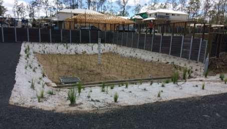
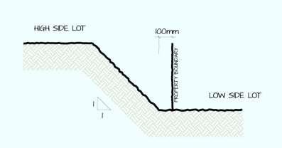
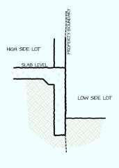
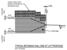
24 Internal Site Constraint Mapping Site Grading, Allotment Benching & Retaining Orientation of Roads and Storm water Channels The grading of the natural terrain of the site will always dictate road orientation unless significant cut and fill is intended across the site. Roads with allotment access to be directed longitudinally perpendicular to contours where possible Narrow allotment frontages allow for smaller retaining walls on boundaries Retaining walls less than 1m in height do not need to comply with the Structural Retaining Wall design codes, therefore cheaper to construct. Retaining Wall heights should be limited to 2.0m in height maximum, but can be agreed to 3.0m with landscape support Limit retaining walls to side and rear allotment boundary and avoid them fronting road reserve and public open space Ensure layout makes sufficient provision for overland flow at the low point of the road Avoid Acid Sulphate Soil earthworks below RL5.0mAHD 07 March


25 07 March

26 07 March

27 07 March
QUEENSTOWN LAKES DISTRICT COUNCIL SUBDIVISION DESIGN GUIDELINES
 Attachment C: Draft QLDC Subdivision Design Guidelines QUEENSTOWN LAKES DISTRICT COUNCIL DESIGN GUIDELINES A DESIGN GUIDE FOR AND DEVELOPMENT IN THE URBAN ZONES QUEENSTOWN OFFICE 10 Gorge Road Queenstown
DRAFT FOR YOUR FEEDBACK DRAFT LOGAN RESERVE PLAN
 DRAFT FOR YOUR FEEDBACK CONTENTS INTRODUCTION... BACKGROUND... State Government... Council... PLANNING LEGISLATION AND RULES... CONSULTATION PROCESS...... ENVIRONMENT AND CONSERVATION... HOUSING... Proposed
OP Council Resolution June 16, Planning and Development Services
 OP-08-01 Council Resolution June 16, 2008 Planning and Development Services Kingsgate Landing Outline Plan Table of Contents 1.0 Introduction 1 1.1 Purpose of Plan 1 1.2 Plan Area Location 1 1.3 Ownership
SECTION 7A: WHAKARONGO RESIDENTIAL AREA
 SECTION 7A: WHAKARONGO RESIDENTIAL AREA CONTENTS 7A.1 Introduction 1 7A.2 Resource Management Issues 1 7A.3 Objectives and Policies 1 7A.4 Methods 4 7A.5 Residential Zone 4 7A.5.1 Rules: Controlled Activities
I615. Westgate Precinct
 I615. Westgate Precinct I615.1. Precinct Description The Westgate Precinct is located approximately 18km west of the Auckland city centre. There are seven Sub-precincts in the Westgate Precinct: Sub-precinct
MASTER PLAN NO. 60 (SITE DEVELOPMENT PLAN EASTBANK/REGATTA NORTH PRECINCTS 2 4) 2008
 2008") Page 2 TABLE OF CONTENTS PAGE 1 PRELIMINARY... 5 1.1 CITATION... 5 1.2 TYPE OF MASTER PLAN... 5 1.3 LEGAL REQUIREMENT FOR MASTER PLAN... 5 1.4 LEGAL EFFECT OF THE MASTER PLAN... 5 2 DESCRIPTION OF LAND...
Page 2 TABLE OF CONTENTS PAGE 1 PRELIMINARY... 5 1.1 CITATION... 5 1.2 TYPE OF MASTER PLAN... 5 1.3 LEGAL REQUIREMENT FOR MASTER PLAN... 5 1.4 LEGAL EFFECT OF THE MASTER PLAN... 5 2 DESCRIPTION OF LAND...
Northern Territory Compact Urban Growth Policy
 Northern Territory Compact Urban Growth Policy A Reference Policy Document to clause 2.7 (Reference to Policy) of the NT Planning Scheme May 2015 Table of Contents 1 Policy Setting... 3 1.1 Context for
Urban Stormwater: Best Practice Environmental Management Guidelines. CSIRO This electronic edition published by CSIRO PUBLISHING, 2006.
 Urban Stormwater: Best Practice Environmental Management Guidelines. Chapter 5 Water Sensitive Urban Design Key references Department of Planning, 1993, Better Drainage: Guidelines for the Multiple Use
Water Sensitive Urban Design Site Development Guidelines and Practice Notes. Appendix
 Water Sensitive Urban Design Site Development Guidelines and Practice Notes Appendix 108 Appendix A Water sensitive developments involve simple design and management practices that take natural site features
COMMUNITY DESIGN. GOAL: Create livable and attractive communities. Intent
 COMMUNITY DESIGN Intent An attractive, well-designed County will attract quality development, instill civic pride, improve the visual character of the community, and create a strong, positive image for
NORTH EAST INDUSTRIAL ZONE
 SECTION 12A: NORTH EAST INDUSTRIAL ZONE CONTENTS 12A.1 Introduction 1 12A.2 Resource Management Issues 2 12A.3 Objectives and Policies 3 12A.4 Rules: Permitted Activities 8 R12A.4.1 Permitted Activities
Infrastructure Servicing Report Barwon Heads Road, Armstrong Creek
 Infrastructure Servicing Report 892-990 Barwon Heads Road, Armstrong Creek May 2015 urban design planning engineering surveying landscape architecture project management www.smec.com DOCUMENT/REPORT CONTROL
MASTER PLAN NO. 40 (SITE DEVELOPMENT PLAN BIRTINYA LAND USE AREA RESIDENTIAL 1) 2007 TABLE OF CONTENTS
 2007 TABLE OF CONTENTS") MASTER PLAN NO. 40 (SITE DEVELOPMENT PLAN BIRTINYA LAND USE AREA RESIDENTIAL 1) 2007 TABLE OF CONTENTS PAGE 1.0 PRELIMINARY 1.1 Citation 1 1.2 Type of Master Plan 1 1.3 Legal Requirement for Master Plan
MASTER PLAN NO. 40 (SITE DEVELOPMENT PLAN BIRTINYA LAND USE AREA RESIDENTIAL 1) 2007 TABLE OF CONTENTS PAGE 1.0 PRELIMINARY 1.1 Citation 1 1.2 Type of Master Plan 1 1.3 Legal Requirement for Master Plan
NAPA COUNTY PUBLIC WORKS Standards & Specifications
 Roadway Design & Construction Manual (Table of Contents) 1. Chapter 1: General Provisions 1.1 Short Title 1.2 Jurisdiction 1.3 Purpose and Effect 1.4 Enactment Authority 1.5 Amendment and Revisions 1.6
FORMER CANADIAN FORCES BASE (CFB) ROCKCLIFFE SECONDARY PLAN. Official Plan Amendment XX to the Official Plan for the City of Ottawa
 ROCKCLIFFE SECONDARY PLAN. Official Plan Amendment XX to the Official Plan for the City of Ottawa") FORMER CANADIAN FORCES BASE (CFB) ROCKCLIFFE SECONDARY PLAN Official Plan Amendment XX to the Official Plan for the City of Ottawa 1 INDEX THE STATEMENT OF COMPONENTS PART A THE PREAMBLE PAGE Purpose...
FORMER CANADIAN FORCES BASE (CFB) ROCKCLIFFE SECONDARY PLAN Official Plan Amendment XX to the Official Plan for the City of Ottawa 1 INDEX THE STATEMENT OF COMPONENTS PART A THE PREAMBLE PAGE Purpose...
Appendix 18F: Tauriko Business Estate Services Strategy Statement and Sequencing Schedule
 Appendix 18F: Tauriko Business Estate Services Strategy Statement and Sequencing Schedule This statement describes key proposals for the development of infrastructure at Tauriko Business Estate. Appendix
Stormwater Regulations & Considerations Morse Study Area. Pam Fortun, P.E. CFM Senior Stormwater Treatment Engineer Engineering Services Division
 Stormwater Regulations & Considerations Morse Study Area Pam Fortun, P.E. CFM Senior Stormwater Treatment Engineer Engineering Services Division Stormwater Regulations Development Considerations Floodplain
LITHGOW CITY COUNCIL DEVELOPMENT CONTROL PLAN ADI LIMITED SITE LITHGOW SMALL ARMS FACTORY METHVEN STREET, LITHGOW
 LITHGOW CITY COUNCIL DEVELOPMENT CONTROL PLAN ADI LIMITED SITE LITHGOW SMALL ARMS FACTORY METHVEN STREET, LITHGOW 6 November 2003 CONTENTS Page 1. INTRODUCTION 1.1 Purpose 1 1.2 Citation 1 1.3 Adoption
AOTEA SUPERMARKET ZONE. Zone Introduction
 C18 AOTEA SUPERMARKET ZONE Zone Introduction C18.1 Objective This zone identifies a specific area in Aotea for a stand alone supermarket. The zone is site specific and has a range of objectives, policies
I539. Smales 2 Precinct
 I539. Smales 2 Precinct I539.1. Precinct Description The Smales 2 Precinct applies to a 4.8 hectare block of land located on the southern side of Northcote Road and fronting Lake Pupuke, Takapuna. The
How to assess a development application under SPA
 How to assess a development application under SPA Alisha Swain Development Assessment Manager Logan City Council If it is good for Logan, socially, environmentally, economically, together we will make
When planning stormwater management facilities, the following principles shall be applied where possible.
 2.0 Principles When planning stormwater management facilities, the following principles shall be applied where possible. 2.0.1 Drainage is a regional phenomenon that does not respect the boundaries between
I403 Beachlands 1 Precinct
 I403. Beachlands 1 I403.1. Precinct Description Beachlands is a rural and coastal village located on the eastern side of Auckland, adjoining the Tamaki Strait coastline. The original Beachlands village
Authority. any changes required as a result of the approved CHMP.
 PLANNING PERMIT Permit No. Planning Scheme Responsible Authority../2013 Greater Geelong Planning Scheme Greater Geelong City Council ADDRESS OF THE LAND 5, 15, 21, 23, 1/23, 25, 33, 40 and 50 Caddys Road;
4.0 Zones and Overlays
 4.0 Zones and Overlays The following section details the existing zones and overlays within the Mooroopna West Growth Corridor. Revision 1 7 July 2009 Page 27 Due to the overall size (260 ha) and geographical
Section 11 Grading and Drainage Standards
 Section 11 Grading and Drainage Standards 11.1 INTRODUCTION The proper grading, conveyance, storage and release of storm water is critical to maintain the integrity of the Property. Drainage facilities,
Advisory notes. Design and siting of buildings and structures. Purpose of these notes. Building setbacks and site coverage.
 Advisory notes Design and siting of buildings and structures Purpose of these notes The design and siting of buildings and structures within the City of Gold Coast (the City) is regulated by a combination
TOWN PLANNING REPORT
 TOWN PLANNING REPORT DEVELOPMENT PERMIT FOR MATERIAL CHANGE OF USE PROPOSED HOTEL, SHOP, MUSEUM AND ENTERTAINMENT & RECREATION (OUTDOORS) 1780-1820 BRIBIE ISLAND ROAD, SANDSTONE POINT LOT 6 ON SP199926
Appendix 1 Structure plan guidelines
 Appendix 1 Structure plan guidelines This appendix forms part of the regional policy statement [rps]. 1.1. Introduction Structure plans are an important method for establishing the pattern of land use
11.3 SPECIAL CHARACTER ZONE HAWKE S BAY REGIONAL SPORTS PARK
 11.3 SPECIAL CHARACTER ZONE HAWKE S BAY REGIONAL SPORTS PARK 11.3.1 INTRODUCTION The availability of sports and recreation activities and facilities is important for the maintenance and enhancement of
Title 11 Streets and Sidewalks
 Chapter 11.01 - Definitions Title 11 Streets and Sidewalks Low Impact Development (LID) - A stormwater and land use management strategy that strives to mimic predisturbance hydrologic processes of infiltration,
Palisades Outline Plan
 NE ¼ 25 36 28 W4 Town of Penhold Approved August 13, 2012 Contents Figures & Tables... 2 Introduction... 1 Overview... 1 Purpose... 1 Development Area... 3 Ownership... 3 Topography... 3 Existing & Surrounding
City of Grande Prairie Development Services Department KENNEDY DEVELOPMENTS LTD. OUTLINE PLAN OP-09-01
 City of Grande Prairie Development Services Department KENNEDY DEVELOPMENTS LTD. OUTLINE PLAN OP-09-01 July 27, 2009 TABLE OF CONTENTS 1.0 Introduction... 1 1.1 Plan Area Location & Context... 1 1.2 Ownership
TIDAPA Structure Plan
 TIDAPA Structure Plan Prepared by Tract Consultants 28 MARCH 2017 0217-0074 Table of Contents 01 STRATEGIC CONTEXT Executive Summary Regional Context Page 3 Page 4 02 LOCAL CONTEXT Aerial Photograph Local
TABLE OF CONTENTS 1.0 INTRODUCTION GENERAL OBJECTIVES LAND USE DESIGNATIONS, OBJECTIVES AND POLICIES 4
 Schedule I- Redstone Golf Course Resort Area Sector Plan 1 TABLE OF CONTENTS 1.0 INTRODUCTION 3 2.0 GENERAL OBJECTIVES 3 3.0 LAND USE DESIGNATIONS, OBJECTIVES AND POLICIES 4 4.0 TRANSPORTATION AND ROAD
SPECIAL 35 (HIBISCUS COAST GATEWAY) ZONE
 ZONE") `` 12.8.35 SPECIAL 35 (HIBISCUS COAST GATEWAY) ZONE 12.8.35.1 Issues The following provisions relate to the Hibiscus Coast Gateway Zone. This zone is located at Silverdale in the area bounded by State
`` 12.8.35 SPECIAL 35 (HIBISCUS COAST GATEWAY) ZONE 12.8.35.1 Issues The following provisions relate to the Hibiscus Coast Gateway Zone. This zone is located at Silverdale in the area bounded by State
Subdivision and Development
 Subdivision and Development 8.0 Introduction - Subdivision and Development The principle purpose of subdivision is to provide a framework for land ownership so that development and activities can take
North Oakville East Parks Facilities Distribution Plan. November, 2009
 North Oakville East November, 2009 POLICY CONTEXT 1) Purpose a) The purpose of this document is to be a guide for the location, configuration, design and development of the parks system for the North Oakville
Section Three, Part 11 Network Utilities, Transport and Roading ELECTRIC POWER, TELECOMMUNICATIONS, GAS, WATER, SEWERAGE, ROADING
 PART 11 NETWORK UTILITIES, TRANSPORT AND ROADING ELECTRIC POWER, TELECOMMUNICATIONS, GAS, WATER, SEWERAGE, ROADING 11.1 INTRODUCTION This part of the District Plan sets out the general provisions for a
General Location Courtyard at LMH Final Development Plan and Final Plat
 R-1 LEYDEN RIDGE LOMA RIDGE LOBDELL R-3 MILLER PARKWAY LAUSSAC Subject Property R-3 LOCHENSHIRE LESMER R General Location Courtyard at LMH Final Development Plan and Final Plat ¹ 230 115 0 230 Feet Airport
CHECKLIST FOR PHASE II DRAINAGE REPORT
 I. COVER SHEET CHECKLIST FOR PHASE II DRAINAGE REPORT A. Name of Project B. Address C. Owner D. Developer E. Engineer F. Submittal date and revision dates as applicable II. GENERAL LOCATION AND DESCRIPTION
I609. Penihana North Precinct
 I609. Penihana North Precinct I609.1. Precinct description The Penihana North Precinct is located south of the Swanson Railway Station, adjacent to the Rural Urban Boundary (RUB) and Waitakere Ranges Heritage
Zoning Ordinance Chapter 10
 CHAPTER 10 - WASHES SECTION 10.0 GENERAL: A. The purpose of this Ordinance is to establish standards for development in or near Major and Minor Washes as defined in Appendix A Glossary of Terms and Definitions
COMPLETE GREEN STREET CHECKLIST
 COMPLETE GREEN STREET CHECKLIST This document was developed to dissect the structure of an urban street and explore opportunities to make our streets more complete while also integrating green street strategies.
Planning and Environment Regulations 2005 Form 9. Draft for exhibition only - v1. Permit no.: WYP6217/12
 PLANNING PERMIT GRANTED UNDER DIVISION 5 OF PART 4 OF THE PLANNING AND ENVIRONMENT ACT 1987 Permit no.: WYP6217/12 Planning scheme: Wyndham Planning Scheme Responsible : City of Wyndham ADDRESS OF THE
CITY OF FORT LUPTON STORM DRAINAGE DESIGN AND TECHNICAL CRITERIA SECTION 10 STREETS
 SECTION 10 STREETS CITY OF FORT LUPTON STORM DRAINAGE DESIGN AND TECHNICAL CRITERIA SECTION 10 STREETS 10.1 INTRODUCTION The criteria presented in this section shall be used in the evaluation of the allowable
DRAFT DESIGN CRITERIA STORMWATER TREATMENT STANDARDS CITY OF OVERLAND PARK
 DRAFT DESIGN CRITERIA STORMWATER TREATMENT STANDARDS CITY OF OVERLAND PARK A. Authority As set forth in the Overland Park Municipal Code (OPMC), Chapter 16.210, the Director of Planning and Development
SCHEDULE 10 TO THE URBAN GROWTH ZONE. Shown on the planning scheme map as UGZ10. Truganina Precinct Structure Plan. 1.0 The Plan
 SCHEDULE 10 TO THE URBAN GROWTH ZONE Shown on the planning scheme map as UGZ10 Truganina Precinct Structure Plan 1.0 The Plan Map 1 shows the future urban structure proposed in the Truganina Precinct Structure
Leduc Industrial Outline Plan SE W4
 Leduc Industrial Outline Plan SE 1-50-25-W4 Within the North Leduc Industrial ASP Prepared for: Leduc Energy Park Ltd. Prepared by: Stantec Consulting Ltd. File No. 1161 104655 V5 Table of Contents 1.0
Appendix H: Easement cross sections
 Appendix H: Easement cross sections SHARED PATH 1.5m FOOTPATH NATURE STRIP 7.3m CARRIAGEWAY 2.7m NATURE STRIP EXISTING PIPELINE 150mm DIA 5.0m (approx.) LOCAL ACCESS ROAD EXISTING PIPELINE 500mm DIA 2.7m
City of Yelm. Tahoma Terra Final Master Plan Development Guidelines. Table of Contents
 City of Yelm Tahoma Terra Final Master Plan Development Guidelines Table of Contents Table of Contents... 1 Purpose... 2 Low Density Residential (R4-6)... 3 Moderate Density Residential (R6-10)... 5 Neighborhood
Part 2 Planning Strategy Master Plan RTA Preferred Pacific Highway Bypass Route Housing Strategy 6
 Contents Part 1 Introduction 1 1.1 Name of the Plan 1 1.2 Land to Which this DCP Applies 1 1.3 Date of Approval and Commencement of this Plan 1 1.4 Amendments 1 1.5 Objectives 1 1.6 What Applications Does
SECTION 2.4 URBAN DEVELOPMENT AND STRATEGIC URBAN DIRECTIONS
 SECTION 2.4 URBAN DEVELOPMENT AND STRATEGIC URBAN DIRECTIONS 2.4.1 INTRODUCTION In 1993/94 the Hastings District Council completed the Hastings Urban Development Strategy. The purpose of this study was:
PORT WHITBY COMMUNITY
 PORT WHITBY COMMUNITY SECONDARY PLAN UPDATE COMMUNITY IMPROVEMENT PLAN URBAN DESIGN GUIDELINES September 2015 DRAFT PROPOSED AMENDMENT NUMBER # to the Whitby Official Plan PURPOSE: The intent of this Amendment
Red Fox Commercial Outline Plan
 Red Fox Commercial Outline Plan City of Cold Lake, Alberta Prepared by Durrance Projects Ltd and Ross W. Sharp & Associates Ltd October 2014 Rupert 1 Table of Contents 1. PURPOSE...3 1.1. Location...4
Chapter 6. Green Streets
 Chapter 6. Green Streets Description Green streets are designed in a holistic manner that minimizes impervious surfaces, emphasizes landscaped elements, includes measures for enhancing water quality, while
Public Consultation. Land at Monks Farm, North Grove. Welcome
 Welcome Welcome to our public exhibition for development on Land at Monks Farm, orth Grove. Gallagher Estates and Gleeson Strategic Land are preparing an outline planning application for new homes, open
Division 5 Reconfiguring a Lot Code
 Division 5 Reconfiguring a Lot Code 12.5.1 Reconfiguring a Lot Code The provisions in this division comprise the Reconfiguring a Lot Code. They are compliance with the Reconfiguring a Lot Code (section
Draft Ada Street Cardiff Area Plan
 Draft Ada Street Cardiff Area Plan (Draft Amendment to Lake Macquarie Development Control Plan 2014) Exhibition: The draft Area Plan is on public exhibition from 29 February 2016 to 29 March 2016. Submissions:
Appendix D - Technical Design Criteria for BMPs
 Appendix D - Technical Design Criteria for BMPs City of Wayzata Page 3 On-site infiltration features Definitions and Scope: Infiltration facilities are constructed basins or depressions located in permeable
Lead Local Flood Authority SuDS Policy Statement
 Lead Local Flood Authority SuDS Policy Statement Meeting Sustainable Drainage System Standards in Hertfordshire Addendum to the Local Flood Risk Management Strategy for Hertfordshire March 2015 Contents
Section Three, Part 16 Takanini Structure Plan Area
 PART 16 TAKANINI STRUCTURE PLAN AREA 16.1 Residential 8 zone 16.1.1 Objectives and Policies 16.1.2 Rules: General 16.1.3 Rules: Activity Status Subdivision (Except within the Addison Neighbourhood Centre)
Design Specifications & Requirements Manual
 11 PARKS & OPEN SPACES 11.1 DEFINITIONS... 1 11.1.1 Neighbourhood Parks... 1 11.1.2 District Parks... 1 11.1.3. Sport Parks... 1 11.1.4 Urban Parks... 1 11.1.5 Civic Spaces... 1 11.1.6 Open Space System...
INFRASTRUCTURE EXISTING INFRASTRUCTURE A. Circulation B. Signals C. Drainage D. Utilities
 7.01. EXISTING INFRASTRUCTURE A. Circulation B. Signals C. Drainage D. Utilities 7.02. PROPOSED INFRASTRUCTURE A. Overall Concept B. Circulation C. Signals D. Drainage 7.03. INFRASTRUCTURE MAP A. Key Infrastructure
4 RESIDENTIAL ZONE. 4.1 Background
 4 RESIDENTIAL ZONE 4.1 Background The residential areas within the City are characterised by mainly lowrise dwellings sited on individual allotments. Past architectural styles, settlement patterns and
I611. Swanson North Precinct
 I611. Swanson North Precinct I611.1. Precinct Description Swanson North is located in the north eastern foothills of the Waitakere Ranges. It is outside the Waitakere Ranges Heritage Area Act and the Waitakere
PROJECT DESCRIPTION ENVIRONMENTAL SETTING. Project Site Location FIGURE 1 - REGIONAL LOCATION MAP
 PROJECT DESCRIPTION ENVIRONMENTAL SETTING Project Site Location The proposed project site is located within the City of Camarillo in Ventura County. As shown in Figure 1, the City of Camarillo is located
14.5 HOPEFIELD: (REFER PLAN 39 AND PLAN 40)
") URBAN DYNAMICS WESTERN CAPE INC. 248 14.5 HOPEFIELD: (REFER PLAN 39 AND PLAN 40) FIGURE 83: LOCALITY - HOPEFIELD Within the context of the Saldanha Bay Municipal area, Hopefield, an historical agricultural
URBAN DYNAMICS WESTERN CAPE INC. 248 14.5 HOPEFIELD: (REFER PLAN 39 AND PLAN 40) FIGURE 83: LOCALITY - HOPEFIELD Within the context of the Saldanha Bay Municipal area, Hopefield, an historical agricultural
GREENVALE CENTRAL PRECINCT STRUCTURE PLAN
 76 Conservation area boundary. Low Fence to exclude vehicles but allow pedestrian access Front boundary of allotment 5.0m MINIMUM SETBACK Path providing public access to dwellings fronting Conservation
15 Rural Residential Zone
 15 Rural Residential Zone Section 15A 15A Purpose of the Rural Residential Zone... 1 15A.1 Objectives and Policies of the Rural Residential Zone... 1 15A.2 Activity Status Rules... 5 15A.3 Permitted Activity
Site layout, density and housing type
 Site layout, density and housing type How can the high densities (up to 30 lots/hectare) be justified in this area and protect adjoining neighbourhood character? The overall site density (15-18 lots/ha)
Planning scheme policy for development works
 SC6.14 SC6.14.1 SC6.14.1.1 Planning scheme policy for development works Introduction Purpose The purpose of this planning scheme policy is to:- provide advice about achieving outcomes in the relevant planning
Section 12B 12B Subdivision in Residential Zones
 Section 12B 12B Subdivision in Residential Zones The Residential Zones provide for a range of infill and greenfield living opportunities across the City for the community to accommodate current and future
Planning Proposal Toronto Road, Booragul. Amendment to Lake Macquarie Local Environmental Plan (LMLEP) 2014
 2014") Planning Proposal Toronto Road, Booragul Amendment to Lake Macquarie Local Environmental Plan (LMLEP) 2014 Local Government Area: Name of Draft LEP: Subject Land: Land Owner: Applicant: Folder Number:
Planning Proposal Toronto Road, Booragul Amendment to Lake Macquarie Local Environmental Plan (LMLEP) 2014 Local Government Area: Name of Draft LEP: Subject Land: Land Owner: Applicant: Folder Number:
Chapter 3 Site Planning and Low Impact Development
 CHAPTER 3 Site Planning and Low Impact Development Chapter 3 Site Planning and Low Impact Development 3.0 Introduction The City of Charleston requires that major residential, large commercial (>1 acre),
Nelson Residential Street Frontage Guideline
 DRAFT 22-06-2012 Nelson Residential Street Frontage Guideline June 2012 1317273 Contents and purpose Residential s are important Residential s are much more than corridors which move traffic. Streets allow
Drexel, Barrell & Co.
 Drexel, Barrell & Co. June 18, 2018 Engineers/Surveyors Boulder Colorado Springs Greeley 3 South 7 th Street Colorado Springs, Colorado 80905-1501 719 260-0887 719 260-8352 Fax El Paso County Planning
Tennessee Stormwater Management Program. Stormwater Management Site Assessment and Inventory Checklist. Quick Check o Vicinity Map within Watershed
 Tennessee Stormwater Management Program Project Name: Location: File Number: Reviewer: Date of Submittal: Review Date: Project Meeting Chronology: Type of Meeting: Date: Stormwater Management Site Assessment
TOP TEN LIST OF COMMUNITY CONCERNS REGARDING PROPOSED AMENDMENTS TO CHAPTER 42
 TOP TEN LIST OF COMMUNITY CONCERNS REGARDING PROPOSED AMENDMENTS TO CHAPTER 42 1. Extend the urban area to Beltway 8 in stages, over say a three-year period, prioritizing development in transit and declining
1. Assessment of Environmental Effects
 1. Assessment of Environmental Effects Table of Contents 1. Introduction and Overview 1 2. Statutory Assessment 3 3. Site Description 5 4. Proposal Description 7 5. Assessment of Effects on the Environment
TOWNSHIP OF LOGAN SOIL & FILL IMPORTATION AND PLACEMENT APPLICATION SUBMITTAL CHECKLIST
 TOWNSHIP OF LOGAN SOIL & FILL IMPORTATION AND PLACEMENT APPLICATION SUBMITTAL CHECKLIST Applications: 5 copies of application - Applicant will reproduce the copies at his/her costs. The Township Clerk
Part 10 Other plans
 Contents of Part 10 Part 10 Other plans... 10-1 10.1 Preliminary... 10-1 10.2 Palmview Structure Plan... 10-2 10.2.1 Preliminary... 10-2 10.2.2 Master Strategic Framework... 10-6 10.2.3 Master Precincts
South of Hillside Road West, Rothbury. Design and Access Statement with Design Code. Outline Planning Application May 2016
 Outline Planning Application May 2016 Design and Access Statement with Design Code Jane Darbyshire and David Kendall Ltd This Design and Access Statement has been produced by Jane Darbyshire and David
I n t r o d u c t i o n
 In this practice note: Preparing an integrated site plan Minimising site disturbance Common mistakes & solutions I n t r o d u c t i o n PRACTICE NOTE WaterSmart development involves simple design and
Rochedale Urban Community Local Plan
 Rochedale Urban Community Local Plan 1. Introduction This Local Plan contains specific additional local planning requirements. Where it conflicts with the requirements of the City Plan, this Local Plan
Design Specifications & Requirements Manual
 11 PARKS & OPEN SPACES 11.1 DEFINITIONS... 1 11.1.1 Neighbourhood Parks... 1 11.1.2 District Parks... 1 11.1.3. Sport Parks... 1 11.1.4 Urban Parks... 1 11.1.5 Civic Spaces... 1 11.1.6 Open Space System...
Part 12 Precinct Area Plans - Wyee West
 TABLE OF CONTENTS 1 INTRODUCTION... 1 1.1 BACKGROUND... 1 1.2 EXTENT OF AREA PLAN... 1 1.3 EXISTING CHARACTER... 2 1.4 ENVIRONMENTAL ATTRIBUTES AND CONSTRAINTS... 2 1.5 DESIRED FUTURE CHARACTER... 3 1.6
Development Permit Application Form. Property Owner Information as Registered on Legal Title Property Owner Name: Phone:
 Development Application Requirements 1 1926 Tsawwassen Drive Tel: 604-943-2112 Tsawwassen, BC V4M 4G2 www.tsawwassenfirstnation.com Canada Development Permit Application Form Name of Applicant: Address:
C ity of Grande Prairie Development Services Department
 C ity of Grande Prairie Development Services Department FAIRWAY DEVELOPMENT OUTLINE PLAN OP 08 09 Approved April 6, 2009 Prepared by: Focus Corporation Table of Contents 1.0. Introduction 2 3 1.1. Plan
I602. Birdwood Precinct
 I602. Birdwood Precinct I602.1. Precinct description The Birdwood Precinct applies to an area west of Don Buck Road and south of Red Hills Road in west Auckland. It incorporates subdivision and development
Drexel, Barrell & Co.
 Drexel, Barrell & Co. December 21, 2018 Engineers/Surveyors Boulder Colorado Springs Greeley 3 South 7 th Street Colorado Springs, Colorado 80905-1501 719 260-0887 719 260-8352 Fax El Paso County Planning
Major Subdivision Sketch Plan Checklist
 This checklist provides specific requirements that are apart of the Sketch process. The entire process is described by the Huntersville Subdivision Review Process which details all the submittal and resubmittal
Introduction How to read this document Land to which this Precinct Structure Plan applies Background information...
 Introduction... 4 How to read this document... 6 Land to which this Precinct Structure Plan applies... 6 Background information... 6 Shepparton North East Development Contributions Plan... 7... 8 OUTCOMES...
The West Vaughan Employment Area Secondary Plan Policies
 Part 2: The West Vaughan Employment Area Secondary Plan Policies 2.1 General Policies It is the policy of Council: 2.1.1. That the West Vaughan Employment Area (the WVEA), identified on Schedule 1, will
Tāhuhu whakaruruhau ā-taone The sheltering ridge pole
 B2. Tāhuhu whakaruruhau ā-taone - Urban growth and form B2.1. Issues Tāhuhu whakaruruhau ā-taone The sheltering ridge pole Auckland s growing population increases demand for housing, employment, business,
EAST VILLAGE STRATEGIC SITE NOVEMBER 2017
 EAST VILLAGE STRATEGIC SITE NOVEMBER 2017 East Village will be a sustainable, mixeduse precinct with a focus on innovative employment and education opportunities. Enhanced by green spaces and places for
Selecting Appropriate Stormwater Control Measures for Your Development Project
 Phase II Post-Construction Stormwater Requirements Workshop - February 10, 2014 Selecting Appropriate Stormwater Control Measures for Your Development Project Jill Bicknell, P.E., EOA, Inc. Outline of
Amendment C146 Melton Planning Scheme Expert Evidence Statement Traffic & Transport Beattys Road, Plumpton
 235 311 Beattys Road, Plumpton 16585REP001C-F 21 November 2016 onemilegrid.com.au 1/59 Keele Street, Collingwood, VIC 3066 (03) 9939 8250 onemilegrid ABN: 79 168 115 679 (03) 9939 8250 1/59 Keele Street
6.6.2 Emerging Community Zone Code Application Purpose and overall outcomes. s6 Zone Codes Emerging Community and Township Zone Codes
 6.6.2 Emerging Community Zone Code 6.6.2.1 Application This code applies to assessable development:- (1) within the Emerging Community Zone as identified on the zoning maps contained within Schedule 2
CA//16/00504/FUL. Canterbury City Council Military Road Canterbury Kent CT1 1YW. Crown copyright and database rights 2016 Ordnance Survey
 O Scale 1:1,250 Map Dated: 09/05/2016 CA//16/00504/FUL Crown copyright and database rights 2016 Ordnance Survey 100019614 Canterbury City Council Military Road Canterbury Kent CT1 1YW AGENDA ITEM NO 13