Ballybay Historic Landscape Characterisation Plan An Action of the County Monaghan Heritage Plan
|
|
|
- Ralf Green
- 5 years ago
- Views:
Transcription

1 BALLYBAY HL CP Ballybay Historic Landscape Characterisation Plan An Action of the County Monaghan Heritage Plan Prepared by Sheridan Woods Architects & Urban Planners
2 BALLYBAY H L C P BALLYBAY, a market and post-town, and a parish, partly in the barony of MONAGHAN, but chiefly in that of CREMORNE, county of MONAGHAN, and province of ULSTER, 8 miles (S. by E.) from Monaghan, and 50 miles (N. W. by N.) from Dublin; containing 6685 inhabitants, of which number, 1947 are in the town. This place, which is situated at the intersection of the roads from Castle-Blayney to Cootehill and Clones, and from Carrickmacross to Monaghan, derives its name from a pass between the lakes at the southern extremity of the town. A battle was fought in the vicinity, at a place called Ballydian, between De Courcy, first Earl of Ulster, and the Mac Mahons and O Carrols. Prior to the introduction of the linen manufacture the town was of very little importance; but since, the establishment of its linen market about the middle of the last century, it has rapidly advanced, and now contains about 400 houses, many of which are respectable and comfortably built, and has become the principal mart for the inhabitants of the surrounding country. The manufacture of linen, of a texture from nine to fourteen hundreds, is extensively carried on throughout the parish. The market is on Saturday, and is amply supplied; great quantities of butter are sold, and from October to February inclusive not less than from 8000 to 12,000 stone of flax is sold weekly: there are also extensive markets for grain on Tuesday and Friday. Fairs are held on the third Saturday in every month, and are remarkable for large sales of horses, horned cattle, and pigs. A reading society was established in 1816, and is supported by a proprietary of annual subscribers; the library contains nearly 1000 volumes. Petty sessions are held in the market-house irregularly: and here is a constabulary police station. The parish comprises, according to the Ordnance survey, 874l 1/4statute acres, of which 181 are in the barony of Monaghan, and /4in that of Cremorne; 180 acres are under water. It was formed by act of council in 1796, by separating from the parishes of Tullycorbet and Aughnamullen several townlands, ap-plotted under the tithe act and valued at 6957 per annum. Its surface is studded with lakes and boldly diversified with hills and dales. About four miles from the town is the mountain of Bunnanimma, at the base of which are bleach-greens and mills. The approach to the town opens upon an extremely beautiful and picturesque tract of country. To the east are seen, at the distance of 20 miles, the deep blue summits of the lofty Slievegullion, with the village, about a quarter of a mile beneath, apparently embosomed in hills and situated on the margin of a lake a mile in diameter, which forms its boundary on the east and south, and is itself bounded by a rich amphitheatre of woods. The soil is of a fair average quality, but agriculture is not in a very forward state: the growth of flax has been much encouraged, and large quantities of very good quality are raised. There is no waste land. Very extensive tracts of bog supply the inhabitants and the various works with abundance of fuel; so great is the quantity consumed that many of the manufacturers employ from 60 to 100 persons for three months every year to dig and prepare it. The draining of these bogs, and the numerous population around the works, have caused a great change in the climate of the Bunnanimma mountain, which formerly was liable to be enveloped in thick fogs for ten or twelve days successively; but now the drying of the turf is seldom interrupted for a single day. The mountain lands, though naturally very poor, have on this side been nearly reclaimed. The prevailing substratum is whinstone; slate also exists, and was formerly quarried for roofing; and there are extensive quarries of greenstone, called Ribbil, of which the town is built. A lead mine was opened at Laragh, about half a mile from the town, but it has not been worked since 1826; it is very rich in ore, and from silver found in it has been manufactured some plate in the possession of Col. C. A. Leslie. About half a mile from the town is Ballibay House, the seat of that gentleman, on whose estate the town is built; it is a handsome and spacious mansion beautifully situated on the border of a lake, and backed by some extensive plantations. The other principal residences in the parish are Derry Valley, the seat of T. McCullagh, Esq.; Aghralane, of T. Lucas, Esq.; and Lake View, the residence of the Rev. Hercules Langrishe, the incumbent. The living is a rectory and vicarage, in the diocese of Clogher, and in the patronage of the Bishop: the tithes amount to The church is a neat edifice occupying a romantic situation on an eminence rising abruptly from the lake; the east window is embellished with stained glass, and there are some tablets to the memory of the Leslie family. The glebe-house is a handsome residence, towards the erection of which the late Board of First Fruits gave 100: the glebe comprises 25 acres. In the R. C. divisions this parish forms part of the union or district of Tullycorbet: the chapel is situated at Ballintra, about a mile and a half from the town; and there is a small chapel of ease in the town, connected with the clergyman s residence. There are two places of worship for Presbyterians in connection with the Synod of Ulster; one of which, in the town, is a handsome building in the later English style, and is of the second class; the other is about a mile distant, and nearly adjoining it is a place of worship for Seceders. About 150 boys and 110 girls are taught in four public schools; and there are also six hedge schools, in which are about 140 boys and 70 girls; and two Sunday schools. A dispensary is open two days in the week for the gratuitous aid of the poor. Lewis Topographical Dictionary of Ireland 1837 Sheridan Woods Architects & Urban Planners
3 Contents 1.0 Introduction 1.1 Objective of the Ballybay HLCP 1.2 Study Area 1.3 Methodology 2.0 Planning and Development Context 2.1 Monaghan County Development Plan County Monaghan Heritage Plan Monaghan Landscape Character Assessment 3.0 Historic Evolution 3.1 At the Mouth of or Approach to the Ford of the Birches 3.2 Hugh Jackson and the Linen Industry 3.3 The Leslie Estate 3.4 The Religious Communities of Ballybay 3.5 Ballybay and the Great Famine 3.6 The Dundalk to Enniskillen Railway 3.7 Ballybay the Market Town 3.8 Ballybay Today 4.0 Survey & Analysis 4.1 Location 4.2 Topography and Landscape 4.3 Archaeology 4.4 Land Use 4.5 Movement and Access 4.6 Townscape 4.7 Architectural Heritage 4.8 Character Areas 5.0 Ballybay Heritage Strategies 5.1 Development Strategy 5.2 Opportunity Sites 5.3 Development Management Guidelines 5.4 Streetscape Recommendations 5.5 Heritage Actions 5.6 Monitoring Appendices
4 BALLYBAY H L C P 1.0 Introduction 2.0 Planning and Development Context In June 2009 Sheridan Woods Architects + Urban Planners in collaboration with Eithne Verling, Museum Consultant and Archaeologist were appointed by Monaghan County Council in association with the Heritage Council to prepare the Ballybay Historic Landscape Characterisation Plan (HLCP). 1.1 Rationale The purpose of the Ballybay HLCP is to provide detailed information and guidance with respect to the protection and enhancement of the historic landscape of Ballybay. The Ballybay HLCP will be consistent with and supportive of the policies of the Monaghan Landscape Character Assessment. Furthermore, it can be used as an independent resource providing more detailed information and guidance on the historic landscape of Ballybay. Although the Ballybay HLCP is not a statutory document, it will be used to inform other plans such at the Ballybay Town Plan and the County Monaghan Heritage Plan. The plan will provide guidance to the Local Authority in undertaking its development management and conservation functions, and to land owners and developers in the preparation of planning applications. The Ballybay HLCP will also be an important tool that can be used in raising awareness of the historic significance of the town. 1.2 Objectives of the Ballybay HLCP The main objectives of the Ballybay HLCP are to: Describe in detail the landscape setting, urban structure, built fabric and archaeology (including potential archaeology) of the town Identify the unique character areas within the town and its environs Record the key urban design elements which contribute to the various character areas identified Establish a detailed inventory of the urban condition of each character area including both natural and built elements Identify features worthy of protection including buildings of architectural, historical, archaeological, artistic, cultural, scientific, social or technical interest, and architectural conservation areas Provide detailed urban design and building guidance for the development of existing and new areas including street layouts, the scale and massing of buildings, materials and finishes and hard and soft landscaping Identify a hierarchy of realistic projects capable of stimulating regeneration within the town 1.3 Study Area The study area for the Ballybay HLCP is consistent with the town boundary as identified in the Ballybay Town Development Plan The Ballybay HLCP seeks to ensure that development occurring within this boundary provides for the protection, preservation and enhancement of historic features which give Ballybay its unique character. 1.4 Methodology The preparation of the Ballybay HLCP comprised the following key stages: Survey and Analysis Public Consultation Recommendations Survey and Analysis In order to understand the historic evolution of Ballybay and the heritage value of the town as it stands today it was necessary to: Establish the planning and development context of the town Undertake a photographic survey of Ballybay including street elevations and important views Review available documentation including local historical sources, the Record of Monuments and Places and the Archaeological Inventory for County Monaghan Analyse aerial photography and historical and contemporary mapping Map the historic significance of the various elements which form the town as we know it today Having completed these tasks, character areas were identified. Public Consultation Members of the public and key stakeholders were invited to a public event held in Ballybay on the 25th of August 2009 as part of Heritage Week. During this event the findings of the survey and analysis stage were presented. An opportunity was also provided to identify the Strengths, Weaknesses, Opportunities and Threats associated with each character area. In doing so, it was possible to tap into the invaluable local knowledge of those attending the event. Recommendations Following the survey and analysis and public consultation stages recommendations were identified for the protection, preservation and enhancement of Ballybay s character areas. These recommendations have been identified with respect to: Maintenance and modifications to existing buildings Development of new areas Promotion and appreciation of Ballybay s built and natural heritage The planning and development context for Ballybay is primarily defined by the Monaghan County Development Plan and the associated Ballybay Town Development Plan, the County Monaghan Heritage Plan and the Monaghan Landscape Character Assessment. 2.1 Monaghan County Development Plan The Monaghan County Development Plan is the primary planning document for the county. The settlement strategy for County Monaghan identifies Ballybay as a Tier 3 settlement having a population between 1,500 and 4,000. The primary objective for Tier 3 settlements is the development of residential and employment centres which act as service and local retail centres for their surrounding hinterland. The following policies apply to all settlements in the county including Ballybay: Designate development limits around urban areas in order to restrict urban and village sprawl and the possible merging of distinctive settlement areas. Promote the development of all settlements, with an appropriate range of facilities and services, including social infrastructure, retail units, commercial offices and local enterprise, in accordance with the settlement hierarchy. Facilitate and/or provide the infrastructure and services necessary to accommodate anticipated population growth in each settlement. Prohibit development in the immediate vicinity of any defined development limit, which would mar the distinction between the open countryside and the built up edge of the settlement. Protect important landscape features within or on the edge of settlements by prohibiting development within designated Local Landscape Policy Areas (LLPAs), unless where it is proven to the satisfaction of the Planning Authority that the proposed development would not detrimentally impact on the amenity of the LLPAs or the wider setting or character of the settlements. Maintain vibrant rural areas by encouraging the sustainable development in these settlements in accordance with the provisions of the Sustainable Rural Housing Guidelines. Establish strong road connections between settlements and promote public transport strategies that could facilitate services from the lower tier settlements. Promote sustainable compact development forms, including more comprehensive backland development of the towns and villages, and promote the efficient use of available public infrastructure and services. Encourage towns and villages to develop specialist niche activities or roles that could help distinguish them and thereby promote their development. Ensure that new development within settlements shall be appropriate in terms of use, siting, scale, layout, design, materials and character. Promote the refurbishment and regeneration of the centre of towns and villages. Encourage residential development on infill sites, derelict sites, vacant plots and backlands. The Monaghan County Development Plan identifies 11 protected structures within the study area. Five local landscape policy areas are also identified within the town boundary. Lough Major and the Dromore River System are identified within the Plan as Proposed Natural Heritage Areas and Areas of Secondary Amenity. Ballybay Town Development Plan The Ballybay Town Development Plan contains additional policies and objectives tailored to the unique characteristics of the town. The Ballybay development plan is fundamentally concerned with promoting growth while protecting its natural and built heritage. The built and natural heritage policies for Ballybay are as follows: Protect and preserve the Protected Monuments and Structures located in Ballybay. Designate an Architectural Conservation Area (ACA) in Ballybay town centre in accordance with DOEHLG Architectural Heritage Protection during the plan period Protect and conserve the streetscape, character, and heritage of the town with particular emphasis on the Square and Main Street. Encourage new developments to refurbish existing buildings and back lands to eliminate dereliction and reinforce the town centre, where possible. Ensure that new development will enhance, respect and compliment the form and scale of the existing town streetscape and architecture. Preserve features which contribute to the townscape and character of the town including archways, facades, stonework, iron railings, etc Ensure the design of shopfronts, signs and advertisements match the overall form and structure of the buildings to which they pertain. Maintain and restore Ballybay Market House during the Plan period Protect Lough Major and the Dromore River System and its environs by prohibiting development within their environs, unless in exceptional circumstances, where it has been proven to the satisfaction of the Planning Authority that the integrity of the Lough and System, and its surrounding landscape will not be threatened. The Ballybay land-use zoning map which has been produced in association with the Town Plan identifies lands upon which particular uses are permitted. Sheridan Woods Architects & Urban Planners

5 2.2 County Monaghan Heritage Plan The aim of the County Monaghan Heritage Plan is: To protect and enhance the built, natural, cultural and community heritage of County Monaghan and to increase awareness, understanding, responsibility and enjoyment of it by all. The plan identifies 93 actions with respect to: Information and Knowledge Education and Awareness Enjoyment of Monaghan s Heritage Heritage and Children / Young People Protecting and Managing Monaghan s Heritage Cross Border Heritage Action Each year an annual work programme is developed which lists practical projects to be undertaken that year. The Ballybay HLCP is an action of the County Monaghan Heritage Plan Monaghan Landscape Character Assessment The Monaghan Landscape Character Assessment identifies, maps and describes the character of the Monaghan landscape and forms the basis for policy formulation and informed decision making regarding the landscape management of the County. Monaghan Rockorry Ballybay Carrickmacross LCA Image Unit 7 - Ballybay Castleblayney Lakelands Castleblayney Ballybay is located in LCA Image Unit 7 - Ballybay Castleblayney Lakelands. as identified by the Monaghan Landscape Character Assessment. The key characteristics of this LCA Image Unit are as follows: Low lying pastoral landscapes with frequent widely spaced drumlins. Numerous loughs, some of which are substantial in size and are among the largest in the County. Regional route following the line of the low lying channel in an east west orientation and linking the town of Ballybay and Castleblayney. Rivers and smaller watercourses following an east west orientation and frequently linking loughs. Scattered designed landscapes including the Fairfield demesne and Dartrey House. Remnants of the industrial past including a dismantled railway line which extends across the landscape from Cootehill to Dundalk via Ballybay and Castleblayney. The Monaghan Landscape Character Assessment includes principles for landscape management and accommodating new development which have been formulated to reflect the landscape conditions and sensitivity of individual LCA Image Units. Principles for landscape management The designed landscapes and remnants of same serve to enhance landscape character and scenic quality. Management plans should include for the replacement of conifer planting with deciduous species or the use of such species as outliers to screen conifer plantings from view. The planting of commercial coniferous forestry near the shorelines of the lakes should be avoided. The maintainence of the hedgerows as an integral part of the farmed field pattern is encouraged. Wire fence boundaries should be replaced with hedgerow plantings. The lake ecological and water quality environment will require protection from sources of pollutants and inappropriate development. Principles for accommodating new development Small scale developments including dwellings can be accommodated discreetly on the lower slopes of the drumlin hills. These ideally ought to be accompanied by planting of native species as hedgerows or woodlands. The lake and lakeshore habitats specifically ought to be protected from almost all forms of development. The visual catchment or geographic areas around each lake from which the lake and associated wetland can be seen would be regarded as highly sensitive to development. Further development on the immediate lakeshore is not recommended. Commercial coniferous forestry is out of character with this landscape especially near the loughs and the remnants of former designed landscapes. Restocking activities should include for the planting of deciduous crops, as outliers at a minimum in order to reduce the visual impact of the conifer plantations. Tall structures will be difficult to site in this almost valley like landscape as these will be visible over a long range. Study Area 1


6 BALLYBAY H L C P 3.0 Historic Evolution This section describes important snapshots in the history of Ballybay which have had a notable influence on the natural, built and social fabric of the town. The objective of this section is not to give a detailed historical account of the development of Ballybay but rather to understand the main historic periods which underpin many of the town s character areas. 3.1 At the Mouth of or Approach to the Ford of the Birches Ballybay or Béal Átha Beithe as it is known in Irish originated as a landmark defined by the mouth of or approach to the ford of the birches, located along the river which flows under Corrybrannan bridge. Historically, this ford may have been the nearest and most convenient crossing point on the Dromore River for travellers moving between Carrickmacross and Monaghan. The Hearth Money Roll of 1663 indicates that Ballybay had not yet become a town by the mid 17th century as it comprised only one taxpayer at that time. It is likely that this taxpayer was a refugee from a dispersed Franciscan house in Monaghan carrying out priestly functions in the Ballybay area. At this time, Ballybay would have been characterised by its natural environment comprising a drumlin landscape, lakes and connecting rivers. 3.2 Hugh Jackson and the Linen Industry The strategic location of Ballybay at the intersection of roads from Carrickmacross to Monaghan and Clones to Castleblayney provided a natural stopping point for travellers. A hostelry and various trades including blacksmiths, saddlers and carpenters soon emerged, taking full advantage of passing traffic. It was during this time that a settlement known as Ballybea came into existence. However, it was not until the 18th century that Ballybay proper was established under the auspices of linen merchant Hugh Jackson. Jackson had been attracted to Ballybay by the suitability of the local area and the Creeve district in particular for the production of flax and linen. Whilst the linen industry had been well established prior to Jackson s arrival, by the mid 18th century Ballybay had grown as a linen town during which time the Jackson s controlled fourteen mills chained to one small river surrounding Ballybay. The Plantation town layout of Ballybay [comprising a square and radiating streets] is credited to Jackson whose achievements included the construction of Ballybay s first Market House as well as many fine town houses and stores. The business acumen of the Jacksons contributed significantly to the development of Ballybay as a market town and by 1800 the Main Street had almost entirely been developed between Corrybrannan bridge and the junction of the Monaghan and Castleblayney roads. Much of Ballybay s character as a town today can be traced to this time. Willoughby s 1786 Estate Map of Ballybay 3.3 The Leslie Estate The development of Ballybay town during the 18th century coincided with the purchase of the Ballybay Estate by Henry Leslie in The estate had formerly been the property of Peter Beaghan, an English land speculator and the father of Margaret Leslie, Henry s wife. Whilst the Leslie s were largely absentee landlords, the family decided in the 1820 s to take up permanent residence on the estate and had a handsome and spacious mansion, tastefully situated on the border of the lake and backed by an extensive plantation constructed to the design of Dublin architect J.B. Keane. The Leslie family undertook significant improvements to the demesne including the planting of thirty acres in one plot overlooking Lough Major. The Leslie s were also responsible for several improvements within Ballybay town including the construction of Christ Church and a new Market House, as well as leasing houses, shops and gardens on favourable terms. Henry Leslie, the grandson of Emily Leslie French, never married and was the last of the Ballybay Leslies. Henry was involved in the negotiations with the Land Commission for the sale of the estate, which occurred in part in March of Following the destruction of Ballybay House by fire in June of that year the remainder of the estate holdings were sold in lots. Despite the destruction of Ballybay House, the influence of the Leslie s and the Leslie Estate on Ballybay continues to manifest itself in the planted landscape setting of the town, the surviving gate house on the Castleblayney Road, the family burial ground at Bell Hill and the Christ Church and Market House buildings within the town. Ballybay House 3.4 The Religious Communities of Ballybay Ballybay has historically been a home to a variety of religious communities including Roman Catholics, Protestants, Presbyterians and Methodists. As previously noted, one of the first recorded inhabitants of the area is likely to have been a refugee from a dispersed Franciscan house in Monaghan carrying out priestly functions in the area. An influx of Scotch Presbyterians into the Mid-Monaghan region towards the end of the 17th century saw the development of several Presbyterian meeting houses in and around Ballybay. The first of these meeting houses (First Ballybay Meeting House) was constructed at Derryvally, to the west of the town, where a mud structure or butóg providing shelter to the minister only had existed from A dispute regarding the appointment of a Mr. Morell as minister of the church saw the development of a separate congregation and meeting house at Derryvally. A subsequent dispute arose following the death of Mr. Morell regarding his successor. Consequently, the Second Ballybay meeting house was constructed on the Clones Road and within close proximity of Ballybay town. The First, Second and Derryvally Presbyterian Meeting Houses are still intact today. Meeting House at Derryvally Whilst Pigot s Directory of 1800 notes the principal inhabitants... of the town and neighbourhood are Presbyterians of different sects, Roman Catholics, Protestants and Methodists also formed an important part of Ballybay s social fabric. Ballybay s Christ Church [Church of Ireland] was constructed in 1798 following the establishment of the parish of Ballybay two years previously. The church was designed by the architect John H. Fullerton, constructed on the lands of Henry Leslie of Ballybay Estate and occupies a prominent position in the town. A sexton s house [now demolished] and schoolhouse were subsequently constructed in 1821 and 1838 respectively. In 1813 a Catholic chapel was constructed to the rear of a Fr. Mohun s residence on the Monaghan Road. Townspeople had previously attended mass in Ballintra and Tullycorbet. Architect William Hague was later commissioned to design St. Patrick s R.C. Church on a prominent site to the north of the Monaghan Road. Construction commenced in 1859 but was not completed until A parochial house associated with the church was constructed in 1883 and later demolished in A Methodist meeting hall was opened on Church Street in 1876 and was subsequently renovated in Renovation works included a new pitch pine ceiling, stained glass windows and repainting. This hall no longer exists. 3.5 Ballybay and the Great Famine The famine began in Monaghan when the potato crop was struck by blight in The development of Ballybay was significantly impacted during this time which saw the town and countryside lose 8% and 30% of its population respectively. In 1846 the Poor Law Commissioners issued instruction for the setting up of Relief Committees in Union Districts. Ballybay was under the Castleblayney Board which concerned itself mainly with Castleblayney town. The Ballybay Committee concentrated its efforts on the provision of food for the destitute. Food provided mainly comprised a vegetable broth cooked in large vats at soup kitchens. One such kitchen was located at Annanesse at the junction of the Cootehill and Shercock roads and still exists today. The Ballybay soup pot had formerly been a steeping vat used in the bleach mills at Creeve and also still survives today. The Leslies and other gentry, the clergy and other inhabitants of Ballybay contributed generously to a relief fund during the famine. The construction of the Market House and drainage and road making on Ballybay Estate were also initiated by the Leslie family as part of a famine relief scheme. Despite these efforts many lives were lost during this period and a graveyard once located to the rear of Shamrock Terrace on Main Street was the final place of rest for the victims of the famine. The effects of the famine continued to effect Ballybay up until the late 1800 s and it was not until long after the great famine that the crops prospered again and the hardship of the famine years was alleviated. However, the cottier and labour classes had been decimated during this time and sections of the countryside were cleared and farms consolidated, with greater emphasis on grazing rather than tillage. Sheridan Woods Architects & Urban Planners


7 3.6 The Dundalk to Enniskillen Railway Ballybay railway station was located on the Dundalk to Enniskillen route which was extended from Castleblayney to Ballybay in 1854 and later to Clones and Enniskillen in 1858 and 1859 respectively. The vibrant market function of Ballybay was an important factor in securing Ballybay s position on the line. Once the line to Enniskillen was completed, there were four trains each way between Dundalk and Enniskillen on weekdays. The arrival of the railway service to Ballybay was an important milestone in the development of the town and its infrastructure in particular. Prior to this, Ballybay did not have its own water supply, drainage system, disposal services, street lighting or proper footpaths. Ballybay s first Town Commissioners were elected in 1870 and in 1871 the Commission held its first meeting. By 1872, a private gas company provided households with gas for lighting and heating and in 1876 were contracted by the Town Commission to provide street lighting. In 1907 the town received piped water from the Creeve Lakes, replacing pumps on St. Patrick s Street, Main Street and at the Market House. The town sewage system was installed the following year and in 1912 an electric street lighting system powered by an oil generator on the Clones Road replaced the gas lamp standards. Accordingly, Ballybay became one of the first small Irish towns to get a public lighting system powered by electricity. By the mid-forties increased road transport for freight and bus services made it increasingly difficult for railway services to remain financially competitive. Consequently, passenger services to Ballybay ceased in 1957 and the line finally closed in In July of 1960 lifting of the track commenced in Dundalk and the last section into Clones was lifted in December of the same year. The railway bridge crossing over Main Street, Ballybay was demolished some years after the railway line closed. However, Ballybay Railway Station and a water tower and railway bridge to the west of Main Street still exist today. Ballybay Railway Station (circa 1910) 3.7 Ballybay the Market Town From 1825 onwards the linen industry in areas such as Ballybay had begun to decline in the context of mechanised spinning, the power loom and steam boiler power. Ballybay subsequently developed as a market town, taking advantage of the infrastructure that had previously catered for the linen trade. Ballybay fairs and markets catered for a farming community largely engaged in mixed farming and the production of a wide variety of marketable items, including cattle, sheep, flax, oats, grass-seed, turnips, potatoes, pork, milk, butter, poultry and eggs, ducks, geese and turkeys in season. One of the Ballybay Town Commission s first undertakings was the regulation of the town s markets. The variety of markets that were held in the town as indicated in the Minute Book of the Town Commissioners demonstrates that Ballybay had once been a thriving hub in the county of Monaghan. The 1835 ordnance survey map indicates a fair green on the Castleblayney Road which was later relocated to Hall Street and was an important trading place within the town. Cattle fair at the Fair Green (circa 1910) 3.8 Ralph Robinson Towards the end of the 19th century horse trading in the town of Ballybay had grown considerable momentum. The fair was officially held on the Monaghan Road between the Catholic Church and the pound on the third Saturday of every month but as trading increased the fair extended into Albert Street and was held on both the Saturday and the proceeding Friday of every month. The construction of the Dundalk to Enniskillen railway line contributed significantly to the success of the fair. In fact, such was the extent of horse trading the Great Northern Railway Company provided an extra siding and loading platforms for horse traffic at the Ballybay Railway Station in orded to facilitate horse buyers. These buyers included officers from the British, Dutch, Belgian and Swiss armies who favoured a particular breed known as The Irish Cob renowned for its stamina and power of recuperation. of Ballybay accruing to some 358 acres. Ralph Robinson also bought the Hotel in the Town Square where he kept 15 employees and constructed several stables, feed stores and a show paddock to the rear of the property. It is likely the Robinson s moved to Ballybay in order to purchase and supply horses to the army buyers who had hitherto purchased their stock directly in the open fair. Ralph Robinson or Raeffe as he was known locally employed several local men with extensive experience in the horse trade who attended fairs all over the country seeking out suitable stock. During the First World War Robinson s business peaked with a weekly output of as much as 300 animals. Much of this stock was purchased by the British Army. By this time that Ballybay established itself as a major horse trading centre supporting related tradesmen such as saddle and harness makers, blacksmiths, farriers and nailers. Local farmers also benefited from the purchase of hay and straw for feed and bedding as did the eating, boarding and public houses which catered for the many buyers, dealers, tanglers and jobbers which came to the town. Although Ralph Robinson died in 1920 horse trading in Ballybay continued up untill the 1940 s at which point vehicular transport began to supersede the horse. 3.9 Ballybay Today Ballybay today is no longer the prosperous town it once was having suffered continuous economic decline for the greatest part of the 20th century. The workforce is largely employed in industrial or commercial activity. Professionally employed persons account for less than 10% of the workforce. New housing areas have developed to the south and north east of the town which has lead to a decline in the resident population of the town core. Consequently, vacant and derelict buildings are commonplace within the town centre. FLAX The market was in the Main Street and carts were to be placed in such positions as the town sergeant and officers direct. Neither buying or selling was to commence until the ringing of the market bell at 9 a.m. To prevent selling over and over again after a sale has been made, every means will be taken to ensure delivery of the first buyer. CORN The market was to be held in the market house, on Tuesdays and Fridays. There was to be no buying or selling before the bell at noon. POTATOES & TURNIPS The market was to be at the market house. AGRICULTURAL IMPLEMENTS & COOPERS The market was to be between Dr. Cathcart s house and MacMahon s hotel after the flax carts have withdrawn. Also opposite McMurray s premises 5 feet from the path. BLACK CATTLE The market was to be only within the enclosure at the cow green and all cattle from Cootehill and Carrickmacross directions were to be driven there through the Meeting House Lane. SHEEP & GOATS From the Clones Road to and if necessary over the bridge. HORSES From the Roman Catholic parochial house outwards and no horses were to be allowed on the footpath. DONKEYS & MULES On the Castleblayney Road at the entrance to the station. PIGS The pig market was to be on Main Street, clear of the path, and on the Friday before the fair day. FOWL From Quinn s Corner to the Police Barracks after the bell at 9 a.m. BUTTER & EGGS From Gray s Corner to the Railway bridge after the bell at 10 a.m. PLANTS On the street opposite Quinn s shop and from there to the pump at the railway. MEAT & ANIMAL FOOD On either side of the shambles. No stall shall project more than 5 feet onto the road. GLASS & EARTHENWARE In the Square STALLS Those selling salt, tin, and hardware from the Square to Gray s Corner. OLD CLOTHES On the Clones Road. Minute Book of Ballybay Town Commissioners 30 March 1871 In the 1890 s the Robinson s, a well known horse trading family from Cappawhite, Co. Tipperary, came to Ballybay to farm at Caddagh. They bought land in almost every townland northwest 3


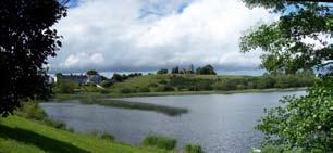
8 BALLYBAY H L C P 4.0 Survey & Analysis This section provides a detailed account of the survey and analysis findings of the Ballybay HLCP. The purpose of this section is to describe the rural and urban landscape of Ballybay as it stands today and to identify the historical features which contribute to its character. Maps describing the survey and analysis of the town are also included in the Appendix. 4.1 Location The development of Ballybay has historically been associated with its strategic location at the convergence of routes from Monaghan, Castleblayney, Clones, Cootehill and Carrickmacross. Furthermore, Ballybay s position on the Dromore river system may have also brought water based traffic to the area during earlier times. As such, the historical function of the town as a stopping place or node for travellers is a long established one which continues today. 4.2 Topography and Landscape Ballybay is characterised by a drumlin landscape comprising rolling hills broken up by rivers and lakes. The most notable landscape feature of the town is its elevated position between Lough Major and Rectory Lake, which largely dictate the eastern and western extremities of the settlement. The Dromore river to the south of the town centre connects these lakes and delineates the southern boundary of the historic settlement. To the north of the town the rising topography of Station Hill provides a landscape backdrop and forms a natural development boundary. There is a extensive area of wetlands to the west of the town Town Map 1835 First Edition Ordnance Survey Map_Ballybay Town 1908 Third Edition Ordnance Survey Map_Ballybay Town An analysis of historical mapping illustrates that most of the historic field boundaries developed by the mid 19th century have been retained. Many of these boundaries comprise mature trees and hedgerows characteristic of Ballybay s pastoral landscape. Within the town itself, the long narrow plots characteristic of the 18th century settlement have been partly retained, with some plots being amalgamated. The settlement pattern in Ballybay is the most notable change to have occurred in the landscape over the last 150 years. The 1835 ordnance survey map illustrates a compact town centre with an extensive rural population. The 1908 ordnance survey map reflects the settlement changes which occurred during the famine and resulted in a notable reduction in the number of rural dwellings in the hinterland. During this time the town core became more intense but expanded only marginally. It was not until the mid to late 20th century that Ballybay and its environs expanded significantly again, the majority of development occurring to the south and north east of the town. For the greatest part, this development has taken the form of housing estates and ribbon development. Other notable landscape changes include the development and subsequent partial removal of field drainage systems on lands liable to flooding to the west of the town and the expansion and contraction of woodland areas to the south and south east of the town First Edition Ordnance Survey Map_Ballybay Study Area 1908 Third Edition Ordnance Survey Map_Ballybay Study Area Sheridan Woods Architects & Urban Planners


9 Landscape Evolution 1835, 1908 & 2009 Settlement Evolution 1835, 1908 &

10 BALLYBAY H L C P 4.3 Archaeology Early Archaeology Monuments Parts of five townlands are included in the area covered by the Ballybay Historic Landscape Characterisation Plan. These are: Corkeeran Cornamucklaglass Corrybrannan Derrynaloobinagh Knocknamaddy Only one recorded archaeological monument is shown within close proximity of the study area boundary in the Record of Monuments and Places. This monument is located in the townland of Corkeeran and is identified on the RMP as an earthwork (site). It also appears as a circular earthwork on maps of Ballybay Estate by Willoughby (1786). This site is located to the northwest of the town on elevated lands to the north of the Monaghan Road. In 1998 an excavation took place in close proximity to this site in preparation for the building of a dwelling house, however, no finds or datable material was found. There are a large number of ringforts and earthworks located outside the study area but within approximately six miles of the town. According to the RMP, sheet 19 of the O.S. 6 Inch map on which Ballybay appears records twenty-two ringforts. The maps to the west, east, north and south record ringfort numbers of between 18 and 37 per sheet. Topographically, all of these sites appear to be located on elevated contours. Ringforts are undoubtedly the most widespread and characteristic archaeological field monument in the Irish countryside and as can be seen from the numbers mentioned above, they are to be found in abundance in this part of County Monaghan. Archaeological excavation has shown that the majority of ringforts were enclosed or defended farmsteads built in the Early Christian Period. Radiocarbon dates place them fairly consistently into the second half of the first millennium A.D. Potential Archaeology The town of Ballybay and the land within its environs is situated on a flood plain. Surrounded by five lakes and a complex river and drainage system (see 3rd ed. OS map of 1908), the town and its hinterland are liable to frequent flooding. In terms of potential archaeology, the nature of this watery topography lends itself to the presence of crannógs and other lakeside settlement sites. The proximity of water sources can also point to the presence of fulachta fiadh or early cooking sites. However, none of these site types have been recorded as yet in the Ballybay area. Crannógs do occur in a number of lakes in Monaghan, and a few have produced associated objects which are recorded in the National Museum. These include sites at Loughaglack, Rahans and Killylarge. There are six crannógs recorded for sheet 19, two, recorded as possible examples lie within a couple of miles of Ballybay, to the south-east in Dunmaurice townland. The absence of fulachta fiadh in Ballybay is curious but may be explained by the fact that little ploughing is/has been done within the study area and its environs because of the liability of flooding. Fulachta fiadh normally come to light when fields are ploughed and the classic burnt earth stain and associated fragmented stones make an appearance in the freshly ploughed soil. When they are intact, they are generally so unobtrusive as to go almost unnoticed or to be mistaken for a mound of field stones or the foundation of a ruined hut. They usually have the appearance of a crescent-shaped grass covered mound and are always close to a water source. Another reason for their absence may be that they were not recorded cartographically by the Ordnance Survey mappers in this area (unlike the mappers in County Cork for example where fulachta fiadh are frequently documented) and have simply not come to light as yet, if that is, they exist here in the first place. Discovered Archaeology (Areas of archaeological sensitivity may exist outside recorded sites) Sheridan Woods Architects & Urban Planners

11 Finds In relation to the other townlands within the study area, no finds or objects were recorded from any of them in the principal national database on finds located in the National Museum. In the book At the Ford of the Birches reference is made to a gold lunala from Ballybay which formed part of the Day Collection and which was acquired by the Ulster Museum. A meeting with a senior curator in the National Museum and a documentary search revealed that there is no specific provenance for this object apart from the historical association with Ballybay. A map of sites on the record of monuments and places is illustrated opposite and an inventory of these monuments is included in Map 9 of the appendix. Townlands Three of the townland names in the study area begin with the prefix Cor, which appears to mean a round hill or a drumlin. Corkeeran is interpreted as Corr Chaorthainn or the round hill of the rowan tree, Cormucknaglass as Corr na Muclach Ghlas the round hill of the green piggeries, Corrybrannan as Corr Uí Braonáin the round hill of the Brennans or O Brennan s round hill. Derrynaloobinagh is interpreted as Doire na Leamhánach the oakwood of the place abounding in little elms and Knocknamaddy or Cnoc na Madraithe the hill of the dogs. It is interesting to note that none of these townland names carry any archaeological reference such as Dún or Rath. The historic town core today still comprises many reminders of the once buoyant linen industry including townhouses on the main street and associated lapping sheds to the rear, the square within which the original Market House stood and the later constructed Market House. Remnants of the railway line include Ballybay railway station and the station master s house, a water tower and railway bridge to the west of Main Street Upper, the site of the former railway bridge crossing on Main Street Upper and partial remains of the embankments along the railway line itself. Other examples of industrial archaeology include the site of the Gas Works and the Gas Works manager s residence on the Clones Road. This archaeology is an important historical reference to the major milestones in the development of Ballybay. Industrial Archaeology Whilst there is limited evidence of early archaeology in the area, there is an abundance of industrial archeology in the wider Ballybay area which includes linen mills [including the Creeve System] and the remains of the Dundalk to Enniskillen railway line. This archaeology has been well documented in the Co. Monaghan Mills Study and the Industrial Heritage Survey of Railways in Counties Monaghan and Louth. Townlands Map Both the linen industry and the railway have been significant in the development of Ballybay and are still very much evident in the built fabric of the town. 7


12 ST. PATRICK STREET BALLYBAY H L C P 4.4 Land Use Ballybay has historically been a service town catering for rural based economies such as the linen industry and the agricultural sector. This function is evident in the large number of long established business premises located on Main Street. Today, the majority of people working in the town are employed in manufacturing and commerce. Industrial uses are primarily located to the north of the town and include Silver Crest Foods, Leonard Engineering and the Ballybay Mart. M.I. Metals and a disused tannery building are located to the south of the town on the Carrickmacross Road. HALL STREET MAIN STREET UPPER Development Under Construction CASTLEBLAYNEY ROAD Retail and commercial uses in Ballybay are generally located in the town centre with the greatest concentration of businesses located on Main Street Upper. Attractive warehouses and stores associated with these buildings are located to the rear and in some cases have been adapted to contemporary uses. In recent years there has been a rise in the number of vacant and derelict buildings in Ballybay, the majority of which are located on Main Street Upper. A survey of the town centre indicated that 8 no. retail / residential buildings are in a derelict condition and an additional 14 no. retail / residential buildings are currently vacant. MEETING HOUSE LANE MAIN STREET CHURCH STREET MAIN STREET LOWER Religious buildings are dispersed throughout the town reflecting the various religious communities that live in Ballybay. The town also comprises several operational and non-operational school buildings including those adjoining the Presbyterian Meeting House, Christ Church and to the east of Main Street Lower [all non-operational] and those on the Castleblayney and Carrickmacross Roads. The evolution of the residential settlement pattern of Ballybay is typical of many Irish towns. Historically, housing within the town centre comprised residential terraces on Main Street Lower, Hall Street, St. Patrick Street, Church Street and Meeting House Lane with dispersed cabins or cottages located in the hinterland. Following the famine landholdings were consolidated and rural dwellings took the form of larger farm houses and Victorian style out of town dwellings. In the early 20th century new housing was constructed on Main Street Lower [Shamrock Terrace], the Castleblayney Road [Pearse Terrace] and on Church Street in the form of attractive two-storey terraces. In the latter half of the 20th century, ribbon development and housing estates have constituted the greatest part of residential development. 4.5 Movement and Access The urban structure of Ballybay is defined by its approach roads and the Main Street, the main thoroughfare through the town. These routes are generally consistent with those illustrated in the 1835 and 1905 ordnance survey maps. It is likely that they were developed in the 18th century as they are not indicated on Charles Price s 1711 map of Ireland. A distinctive feature of Ballybay s urban structure is the provision of access to the rear of properties on the Main Street via archways and narrow lanes. The approach routes to the town are of importance not only because they connect Ballybay to other towns and settlements but also because it is from these routes that travellers first experience a sense of arrival to the town. Whilst today the town Movement & Access is approached by road, for almost a century Ballybay was also accessible by train, which would have afforded panoramic views south towards Lough Major, Ballybay Estate and Knocknamaddy Woods. Pedestrian routes are also an important aspect of the town s urban structure and particularly in terms of providing access to Lough Major and its surroundings. In the 19th century Emily Leslie generously made the grounds of Ballybay Estate accessible to the people of Ballybay on special occasions which would have been facilitated by the various routes through the estate illustrated on the 1908 OS map. Today, many of these routes are still accessible and are a valuable source of recreational amenity. Land Uses The historic core of Ballybay is located within a 400 metre walkband of the town centre which reflects the limited means of transport available during the early development of Ballybay. It is not until the late 20th century that significant development beyond this walkband occurs reflecting a rise in car ownership. Increased mobility has resulted in a greater number of people living outside the town centre in large detached homes or housing estates and a significant reduction in the resident population of the town core. Sheridan Woods Architects & Urban Planners
13 PA Development Under Construction FR Development Under Construction Development Under Construction SILVERCREST FOODS SILVERCREST FOODS CEMETERY CEMETERY NO SILVERCREST FOODS CEMETERY UR IC K ST.P AT R SCHOOL IC ST ET K ST ENGINEERING WORKS RE ENGINEERING WORKS RE PL SCHOOL SCHOOL ST.P AT R ET ST.P AT R IC K ST RE E DE ENGINEERING WORKS T Y ROAD D Y ROA LEBLAYNE HALL ET Development Under Construction STRE HO HO G TIN EE M Development Under Construction Development Under Construction STRE TR WE G TIN EE M ET STRE ET MAIN STREET UPPER MAIN STREET UPPER HALL HALL CAST MAIN STREET UPPER Y ROAD AYNE CASTLEBL AYNE CASTLEBL MART E US G TIN EE M NE LA NE LA E US MART HO T T REE REE N ST N ST MAI NE LA MAI BR MAI E US MART CH STRE ET CH CHUR STRE ET REE N ST CHUR T ET CH CHUR STRE ST MAI ER LOW ER LOW REET REET N ST N ST MAI MAI N ST REET ER LOW Building Frontage, Plot Configurations & Boundaries Views & Landmarks SCHOOL SCHOOL 4.6 Townscape The character of Ballybay town is largely derived from its natural and built environment. SCHOOL The principal landscape elements which contribute to the character of the area are: Lough Major, Rectory Lake and the Dromore River The undulating topography of Main Street Drumlin hills and valleys including Station Hill, Sheep Hill / Knocknamaddy Hill and Corrybrannan Hill Cultivated farmland and wetlands Designed woodlands, tree groups and hedgerows Panoramic views from the main approach roads The principal built elements within the historic town comprise: A mix of 18th and 19th century townhouses and terraces Attractive outbuildings and stores to the rear of Main Street east and west Strong building frontage along Main Street, St. Patrick Street and the southern side of the Castleblayney Road and Hall Street A fine urban grain along Main Street Major landmark buildings including St. Patrick s Church, Christ Church, the Second Ballybay Meeting House, the Market Building and the Riverdale Hotel Minor landmark buildings including the railway station, the Bank of Ireland, McGinnity s (Former Northern Bank) and the Department of Agriculture and Food offices Short distance and panoramic views to the lakes and the rural hinterland Landscape Framed views to backland areas and stores Long distance views to St. Patrick s Church and Christ Church from Main Street, Hall Street, the Square and the town park Nodes including the Square, the junction of Main Street and the Castleblayney Road and the Town Park Derelict, vacant and poorly maintained buildings Outside the historic core the built environment is characterised by: A photographic survey and analysis of the principal streets in Ballybay has been undertaken. In the course of this survey, each building was given a reference number which has been recorded on an index map. Street sections, which involved the measurement of building heights and street widths at various locations, were also undertaken as well as a detailed streetscape analysis. The following pages contain the findings of this survey and analysis. An index map which indicates building reference numbers and the location of street sections recorded is also appended. Attractive Victorian style out of town residences on the Monaghan Road Traditional farm houses and farm complexes Uniform residential estates comprising two storey detached and semi-detached houses Ribbon development along major and minor roads Large industrial buildings 9

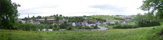
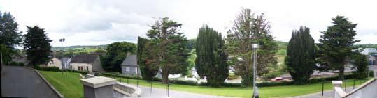
14 BALLYBAY H L C P Panoramic Views The landscape setting of Ballybay is primarily experienced from the main approach roads to the town. The undulating nature of the topography and its associated lakes and wetlands have largely determined the alignment of these routes. For this reason, the first glimpses of the settlement are experienced as routes descend from a height or navigate around a drumlin. The steeple of St. Patrick s Church is particularly prominent from these routes. Within the town, the elevated site of Christ Church provides panoramic views across Lough Major and to the drumlins beyond. Picturesque views of Lough Major with Christ Church elevated in the background can be enjoyed at several locations along Lochmor Avenue. To the west of the town, panoramic views comprising the wetlands and the Mullananalt wind farm to the south west of the town can be seen from Meeting House Lane. Panoramic Views Key Map Sheridan Woods Architects & Urban Planners


15 VIEW 01 VIEW 02 VIEW 03 VIEW 04 VIEW 05 VIEW 06 VIEW 07 VIEW 08 VIEW 09 VIEW 10 VIEW 11 VIEW 12 VIEW 13 VIEW 14 VIEW 15 VIEW 16 VIEW 17 VIEW 18 VIEW 19 VIEW 20 11

16 BALLYBAY H L C P Main Street Upper Urban Analysis Historic Landscape Estate Planned Town & Market Place in Post Character Areas Medieval Planned Settlement Character Principal commercial street Land Use Mix of small and medium scale retail and commercial uses with residential accommodation on upper floors Movement Major street / thoroughfare Two way vehicular traffic - double carriageway Car Parking On-street parallel car parking on both sides of the street, perpendicular car parking provided at the Square Street Section 1:2-1:3.5 [The Square] Plot Configuration Long narrow plots on both sides of the street Grain Fine urban grain throughout Building Line Strong building line on east and west side of the street Building Height 2-3 storeys [Primarily 3 storeys] Building Typologies Substantial townhouses and commercial buildings [Several Vacant / Derelict] Scale and Massing Small to large scale townhouses and commercial premises of simple form and human scale Landmark Buildings Bank of Ireland, Department of Agriculture and Food offices, Stookie s Public House [Prominent gable elevation], McGinnity s Shop Noteworthy Buildings Crawford s Drapers Urban Spaces / Node The Square, junction of Main Street and St. Patrick Street Key Views Short distance views to Station Hill and the Square, framed views to western hinterland Long distance view to St. Patrick s Church Footpaths metres in width Predominantly concrete block paving [including parallel parking bays] Areas of insitu. concrete and tarmac to front of Slowey s Bar, Ballybay Pharmacy, McGinnity s and McAviney s Tactile paving at street junctions and crossings Boundaries Attractive railing to front of Ardmore House Street Furniture Litter bins and bollards dispersed throughout Telephone Kiosk and stone seating in the Square Disused petrol pumps outside the Steakhouse Lighting Predominantly timber / steel poles with projecting lamp fitting, heritage lamp stands in the Square Wirescape Telephone cables fixed to lamp standards Trees Trees planted on western side of the Square ST. PATRICK STREET MAIN STREET UPPER MAIN STREET Main Street Upper East Urban Analysis Main Street Upper West Sheridan Woods Architects & Urban Planners


17 Main Street Upper East Contd. 11.8m 1.8m 1.9m 6.5m 1.4m 26.8m 2.3m 2.1m 13.5m 4.4m 4.4m Street Section 1:3.5 Street Section 1:2 8.4m 5.9m 7.8m 7.5m Section CC Section EE Typical Street Sections Main Street Upper West Contd. 13

18 BALLYBAY H L C P Main Street Lower Urban Analysis Historic Landscape Estate Planned Town, Early 20th Century Character Areas Terraced Housing & Victorian Suburban Villa Character Principal residential street Land Use Predominantly residential buildings, some small retail and commercial uses Movement Major street / thoroughfare Two way vehicular traffic - double carriageway Car Parking On-street parallel car parking on both sides of the street Street Section 1:3 Plot Configuration Plot configurations vary and include narrow, long plots to the rear of Shamrock Terrace, narrow short plots to the rear of buildings opposite Shamrock Terrace and wide long plots to the west of the street Grain Fine urban grain throughout Building Line Strong building line on west side of street and moderate building line on east side of street where terraces end and buildings are set back Building Height 2-3 storeys [Primarily 2 storeys] Building Typologies Modest townhouses and terraces punctuated by Market House, former clinic and garage buildings Scale and Massing Domestic scale houses of simple form and human scale, Market House of civic scale Landmark Buildings Market House and the Riverdale Hotel Noteworthy Buildings Former clinic building Urban Spaces / Node Market House forecourt Key Views Short distance views to Church Lane, framed views to western hinterland Long distance view to St. Patrick s Church Footpaths 1-5 metres in width Predominantly insitu. concrete Block paving surrounding Market House and adjacent Corrybrannan bridge Boundaries Attractive railings to front of Shamrock Terrace and former clinic building Street Furniture Post box and Famine memorial plaque at the Market House Timber seating at Corrybrannan bridge Lighting Timber / metal poles with projecting street lamp Wirescape Telephone cables fixed to lamp standards High concentration of television antennas on roofscape Trees Tree planted to front of Market House TREET CHURCH STREET MAIN STREET LOWER Main Street Lower East Urban Analysis Main Street Lower West Sheridan Woods Architects & Urban Planners


19 Main Street Lower East Contd. 22.1m 9.5m 11.2m 1.3m 14.7m 1.8m 11.1m 1.7m Street Section 1:3 10.7m Street Section 1:3 7.2m 5.3m 5.2m Section HH Section II Typical Street Sections Main Street Lower West Contd. 15
20 BALLYBAY H L C P St. Patrick Street (formerly Albert Street) Urban Analysis Historic Landscape Estate Planned Town & Church Complex Character Areas Character Approach road Land Use Primarily residential buildings, some commercial and industrial buildings Movement Principal approach road Two way vehicular traffic - double carriageway Car Parking On-street parallel car parking on both sides of the street Street Section 1:3.8 Plot Configuration Long narrow plots on north side of street, narrow short plots on south side of street Grain Fine urban grain throughout Building Line Strong building line on north side of street, building line gradually weakens on south side of street due to free standing and set back buildings Building Height 1-3 storeys [Primarily 2 storeys] Building Typologies Modest terraces of town houses and cottages, Neo-Gothic church, meeting hall and cinema building Scale and Massing Primarily domestic scale townhouses of simple form and human scale Landmark Buildings St. Patrick s Church Noteworthy Buildings Former St. Patrick s Hall Urban Spaces / Node Dedicated seating area at location of demolished railway bridge Key Views Short distance views to water tower and Castleblayney Road Panoramic views of hinterland to south Footpaths 1-3 metres in width Insitu. concrete on south side, block paving on north side Boundaries Attractive stone wall adjoining St. Patrick s Church Street Furniture Not applicable Lighting Timber / metal poles with projecting lamp fitting Wirescape Telephone cables fixed to street lamp High concentration of television antennas and satellite dishes on roofscape Trees Tree groups to front of St. Patrick s Church ST. PATRICK STREET Urban Analysis 4.1m Section AA 15.6m 2.4m 10.2m 2.9m Street Section 1:3.8 St. Patrick Street North 6.1m Typical Street Section St. Patrick Street South Sheridan Woods Architects & Urban Planners
21 Castleblayney Road Urban Analysis Historic Landscape Planned Estate Town, Victorian Suburban Villas, Character Areas Early 20th Century Terraced Housing, Petrol Station & Railway and Associated Marshalling Yards etc. Character Approach road Land Use Mix of small scale retail uses and residential buildings Movement Principal approach road Two way vehicular traffic - double carriageway Car Parking On-street parallel car parking outside Centra Perpendicular car parking on north side of street Street Section 1:1.3 Plot Configuration Mixture of long narrow plots and long wide plots on south side of street, large plots on north side of street Grain Fine to medium urban grain on south side of street Building Line Strong building line on south side of street punctuated by breaks in terraces and detached and set back buildings Building line on north side of street defined by mixed quality walls and station master s house Building Height 2-3 storeys Building Typologies Mix of townhouses, commercial buildings and terraced housing on south side of street Railway buildings and industrial buildings on north side of street Scale and Massing Small to large scale townhouses of simple form and human scale Landmark Buildings Station master s house, gate house to Ballybay estate Noteworthy Buildings Ballybay railway station, Ward s Harware Store (site of original RIC / Garda station) Urban Spaces / Node Not applicable Key Views Short distant views to Main Street and St. Patrick Street junction Footpaths metres in width Predominantly insitu. concrete Block paving from Main Street to Ward s Hardware Merchants Boundaries Attractive stone wall to north of street Street Furniture Bollards dispersed throughout Lighting Timber / metal poles with projecting street lamp Wirescape Telephone cables fixed to lamp standards Trees Mature trees at entrance to engineering works MAIN STREET U ENGINEERING WORKS CASTLEBLAYNEY ROAD SCHOOL Urban Analysis Section BB varies Castleblayney Road 7.4m 9m 1.5m Street Section 1: m Typical Street Section Castleblayney Road Contd. 17

22 BALLYBAY H L C P Church Street Urban Analysis Historic Landscape Estate Planned Town, Early 20th Century Character Areas Terrace, Late 20th-21st Century Terraced Housing, Late 20th-21st Century Suburban Estate & Church Complex Character Residential Lane Land Use Residential houses and cottages and community building Movement Minor street / access lane Two way vehicular traffic - single carriageway Car Parking On-street parallel car parking on north side of lane Street Section 1:2.8 Plot Configuration Narrow shallow plots on north side of lane Wider shallow plots on south side of lane Grain Fine to medium urban grain throughout Building Line Strong building line on north side of lane Moderate building line on south side of lane Building Height 1-3 storeys [Primarily 2 storeys] Building Typologies Cottages, terraced houses and former school building Scale and Massing Small scale townhouses of simple form and human scale Landmark Buildings Christ Church Noteworthy Buildings Former school building, toll booth / weigh bridge station to side of Market House Urban Spaces / Nodes Entrance gate to Christ Church Key Views Short distant views to Christ Church Footpaths 1 metre in width Insitu. concrete on north side of lane No footpath to south side of lane Boundaries Attractive boundary and entrance gate to Christ Church Street Furniture Not applicable Lighting Projecting street lamp fixed to telegraph poles Wirescape Telegraph poles on south side of lane Satellite dishes fixed to front elevations of buildings on north side of lane Trees Not applicable MAIN STREET CHURCH STREET MART Church Street North 13.9m 1.0m 8.2m 4.3m Street Section 1: m 4.8m Urban Analysis Typical Street Section Church Street South Sheridan Woods Architects & Urban Planners

23 Hall Street Urban Analysis Historic Landscape Planned Estate Town, Late 20th-21st Century Character Areas Terraced Housing & 19the Century School Character Approach Road Land Use Residential and community uses Movement Approach road Two way vehicular traffic - double carriageway Car Parking Not applicable Street Section 1:1.2 Plot Configuration Short narrow plots on south side of street Large plots on north side of street Grain Fine urban grain on south side of street broken by detached former gas manager s house Coarse grain on north side of street with the exception of terrace of 3 no. houses Building Line Strong building line on south side of street defined by terraces and attractive walls Building line on north side of street largely defined by attractive stone wall Building Height 2-3 storeys [Primarily 2 storeys] Building Typologies Modest terraces and detached house Meeting House and former school building Scale and Massing Domestic scale houses of simple form Monumental scale church building Landmark Buildings Second Ballybay Presbyterian Meeting House Noteworthy Buildings Former school building and teacher s residence Urban Spaces / Nodes Entrance area to Meeting House and graveyard Key Views Short distant views toward Clones Road Panoramic views to southern hinterland Footpaths metres in width Boundaries Attractive stone wall with railing and entrance gates to front of Meeting House and former school Attractive stone wall adjoining terrace of houses to north of street and former gas manager s house Street Furniture Not applicable Lighting Timber / metal poles with projecting street lamp Wirescape Telegraph poles on south side of street Trees Mature trees to front of Meeting House MEETING HOUS HALL STREET Urban Analysis REET UPPER 7.8m Section DD 7.8m 1.2m 5.7m 1.0m Street Section 1: m Typical Street Section Hall Street South Hall Street North 19


24 BALLYBAY H L C P 4.7 Architectural Heritage Ballybay has a rich architectural heritage dating from the 1700 s to the present day. It is characterised by public and civic buildings, residential buildings, retail, commercial and industrial buildings and shop fronts. The town provides examples of defining eras in architectural style, which manifests themselves in the design, detailing and craftsmanship of individual buildings. There are 7 no. protected structures in the town which are considered to be of Regional significance. These structures include: Ref. No. Status Structure Regional St. Patrick s Catholic Church, Monaghan Road, Ballybay Regional Ballybay Second Presbyterian Church, Clones Road, Ballybay Regional Terraced, three bay, three storey house & shopfront, Main St., Ballybay Regional Library, Main St., Ballybay Regional Ballybay Market House, Main St., Ballybay Regional Christ Church Ballybay Regional Terraced, three bay, three storey house commercial premises, Main St., Ballybay There are also 5 no. protected structures of local status within the town. These structures are: Ref. No. Status Structure Local 50 Local Railway Bridge, Cornamuckglas, Ballybay Local 51 Local Water Tower, Cornamuckglas, Ballybay Local 54 Local A.Marron Shopfront, Main Street, Ballybay Local Murnane s Shopfront, Main Street, Ballybay Local Crawford s Shopfront, Main Street, Ballybay Public and Civic Buildings Public and civic buildings are located throughout the town. These include a range of historic and contemporary structures, and comprise religious buildings, schools, the former train station and the gas works. Religious Buildings The variety and number of religious structures in the town reflects the varied number of religious faiths in the area, including Church of Ireland, Presbyterian, Methodist and Roman Catholic. Christ Church [Map Ref. No. 217] Christ Church [Church of Ireland] was constructed in 1798 on Church Hill, to the east of Main Street and accessed via Church Street. The church was commissioned by the Leslie family. It is described as a simple church of Ireland sited on one of the two highest points in Ballybay, the other home to the later Catholic Church. Unusually for such a small church it has transepts. In the early 1880 s the architect J.H. Fullerton did some work on the Church including enlarging or rebuilding the chancel. The Lewis Topographical Dictionary of Ireland describes Christ Church as follows: The church is a neat edifice occupying a romantic situation on an eminence rising abruptly from the lake; the east window is embellished with stained glass, and there are some tablets to the memory of the Leslie family. Christ Church [Church of Ireland] Second Ballybay Presbyterian Church [Map Ref. No. 050] As previously noted, the first Presbyterian church in Ballybay is located to the east of the town at Derryvally. A Presbyterian Church was later built in 1834 on the Clones Road in Ballybay town and appears on the 1835 OS map, indicated as Presbyterian Meeting Hall. It is referred to as the Second Presbyterian Church in the 1908 OS map. This church is described as a handsome building in the later English style in the Lewis Topographical Dictionary of Second Ballybay Presbyterian Church St. Patrick s Catholic Church [Map Ref. No. 323] The original catholic chapel in Ballybay was constructed to the south of the Monaghan Road in This chapel was later replaced by St. Patrick s Church to the north upon which construction commenced in 1859 and was completed in The church was designed by the architect William Hague who was an architect of Cavan and Dublin. He established a flourishing practice, particularly as a prolific designer of Catholic churches, designing or altering some forty to fifty churches throughout the country. St. Patrick s Church is Hague s first recorded church and unlike his other early work it has a strong early Gothic influence. The church spire boasts a height of 163 feet which is a prominent feature of the Ballybay skyline. The Dublin Building Journal of 1 December 1859 described the design as follows: The building itself, which is to occupy a very conspicuous situation, will consist of a tower on the south elevation [constructed on the north elevation], through which will be the principal entrance: a handsome porch on the north side, and transepts on the north and south elevations, lighted by a tall double lancet window with quatrefoil above. The church is very Puginistic with every part of it being read from the outside. The chancel, nave, aisles and tower are all distinct from each other. Hague has also gone for long lancet windows, but where the Public would have had a porch as an entrance, Hague takes the people through the tower, a characteristic which he was to employ in many of his later churches. St. Patrick s Roman Catholic Church Schools There are three historic school structures in the town. These include Ballybay Irish Church school on Church Street, Ballybay National Boys School, to the rear of the former Ballybay Clinic and the former Presbyterian school to the north of the Clones Road. The contemporary schools are located adjacent to the town centre. These include the combined St. Brigid s Girls School and St. Patrick s Boys School [Scoil Éanna] and Ballybay Central National School on the Castleblayney Road, and Ballybay Community College [secondary level] to the south of the town. Irish Church School, Church Street [Map Ref. No. 216] The Irish Church school was commissioned by the Leslie family and built circa This building is located on Church Street adjoining Christ Church. The school was extended in 1878 to the design of the architect John Henry Fullerton which comprised the construction of side wings forming a T shaped plan. The school was later used as a Church of Ireland community centre serving the local Orange Lodge. Significant alterations have been made to the original structure including the application of a pebble dash render, the removal of decorative mouldings and the replacement of original windows and doors. The school was also reroofed using slate from the church at Tullycorbet. Irish Church School, Church Street Ballybay National Boys School [Map Ref. No. 186] A plaque on the front of this building incorrectly states Ballybay National Boys School This original plaque was damaged following attempts to remove it and subsequently reinscribed incorrectly. Local sources cite 1872 as the year of construction and the teaching of boys and girls in Ballybay National School up until A teacher s residence was also constructed to the south of the school. This school was closed in the 1970 s with the construction of a single school building housing St. Patrick s Boys school and St. Brigid s Girls school. Ballybay National School is a detached single storey structure comprising stone walls with dressed stone plinth, square headed window openings and brick reveals, hipped slate roof with rendered and brick chimney stacks. Seven bays to front elevation comprising replacement upvc windows. Ballybay National School Sheridan Woods Architects & Urban Planners


25 Hall Street National School [Map No. 048] This school replaced an earlier two storey structure which had been destroyed by fire and had accommodated a school room on the first floor and a store underneath. James Irwin of Cumry was the contractor. Two roundels on the building bear the inscription Temperance Hall The school was extended to the rear in A teacher s residence was constructed to the north of the school. This building is simple in form and decoration comprising a seven bay single storey L shaped structure with lime rendered walls and quoins and pitched slate roof with gables. Symmetrical front elevation with two entrance doors and two over two timber sash windows. Original entrance doors replaced. Attractive dressed stone wall, iron railing and pedestrian gate to front boundary with stone steps and Y shaped path with stone kerbs leading to entrance doors. Hall Street National School Market House [Map Ref. No. 204] The Market House is attributed to the architect William Walker and was built in The principal elevation faces Main Street Lower and the north gable faces Church Street. The multifunctional use of this building has contributed significantly to the social and economic development of the town. The building design, aesthetic, and craftsmanship in its construction make the building a landmark, which contributes significantly to the streetscape and image of Ballybay. The building is a detached four bay, two storey building, with pedimented breakfront to the centre of the front elevation and a hipped slate roof. The ground floor is open in plan to the front, with accommodation to the rear of the plan and at first floor. The walls are finished in limestone masonry to the ground floor, and rusticated coursed limestone walls to the first floor, with carved limestone string courses and dressed limestone quoins. Arched openings to the ground floor, with dressed limestone archway and keystones. First floor windows centred above archways, with square headed dressed limestone architrave with decorative detail over head, and stone sill forming sill course. Carved limestone plaque centred between first floor windows with the dates of the construction of the building. Brick lunette centred within the pediment. Windows comprising square headed six over six timber sash windows. Gable elevation including two blind recessed windows. External stone cut stair to the rear, providing access to first floor from Church Street. This building was constructed to replace the former market building that was previously located in the town square. It was designed to fulfil a multifunctional role that the former market building had adopted. The market and associated offices are located at ground floor and the first floor provides a large assembly room, public rooms and a former rent office. The first floor accommodation acted as a temporary school building, a courthouse, a library, and a concert and dance hall. A timber stairs provides access from the southern bay on Main Street to a rent room on the first floor. This room was used as the antichamber by the Justice of the Peace or the District Judge who presided at petty sessions and local courts. Market House The building displays the characteristics of neo-classical architecture with a symmetrical façade and pleasing proportions. The stone work and cast iron gates are attractive and reflect the quality of craftsmanship in the area. Ballybay Railway Station & Associated Structures The railway station [Map Ref. No. 299] was built in 1860, designed by architect George William Murray. Murray was responsible for some major banks and insurance offices in Dublin and was the winner of a limited competition for the Royal College of physicians in Kildare Street, Dublin. He was the architect to the Dundalk, Enniskillen and Londonderry Railway Company, the South Dublin Union, and the provincial Bank of Ireland. Historical photographs of the station suggest a building of gothic inspiration. However, the use of render maintains a simplified aesthetic. Modifications to the building have included stripping of decoration from the building. Although the scale and form of the structure is consistent with the original, the station has lost much of its character and fine detailing. The station house [Map Ref. No. 298] to the south of the railway station retains many of its original features and is a prominent landmark on the Castleblayney Road. To the west of the station and Main Street Upper a water tower [Map Ref. No. 004] used to fill the loco tenders also still remains. This structure was not built until 1921 and is distinct from other water tanks on the line due to its attractive brick construction and window openings. A nearby arched masonry bridge carries the embanked line over the Dromore River. No elements of the railway bridge which once crossed over Main Street remain in place today. Other remaining structures of interest include a signal box and a goods office. Ballybay Railway Station A survey of Ballybay station and associated structures has been undertaken as part of An Industrial Heritage Survey of Railways in Counties Monaghan and Louth and includes a detailed description and appraisal of the complex. Gas Works [Map Ref. No. 060] As previously noted, following the elevation of town commissioners in 1870, a private gas company provided households with gas for lighting, heating and street lighting. The location of the gas works is noted on the 1908 OS map as well as a complex of buildings consistent in configuration with those present today. These buildings include the gas manager s residence. The building fronts onto the Clones Road. The structure is an attractive, solidly constructed building displaying good craftsmanship in construction. The gas manager s house is a detached single storey three bay dwelling with pitched roof and brick chimneys, rusticated stone walls, brick window reveals, and dressed limestone plinth and quoins. Square headed window opes, with two over two timber sash windows, limestone sills, and square headed timber Gas Manager s House, Hall Street panelled door with over light and stone steps. A stone outhouse and stone wall with attractive pillars similar to those at the entrances to the Ballybay estate are located to the rear of the site on Meeting House Lane. A gas meter which measured the consumption of gas in the town was located on a lamp standard in the Fair Green. The gas works were forced to close down in 1912 because of the coal miners strike in England. The gas meter was subsequently removed. Ballybay Clinic [Map Ref. No. 184] The former Ballybay Clinic was designed by John F. McGahon Architects of Dundalk. John F. McGahon architects were responsible for both public and private works, including residential works, particularly labourers houses in Louth and Monaghan, and public works for the Dundalk Harbour Board, Health Board and VEC. The practice commenced in 1901, and was continued in 1931 when the son of John Francis McGahon joined the practice. The style of architecture altered during the intervening years reflecting changes in design trends. The later work in the 1930 s displayed an art deco design approach, reflected in other work carried out by the practice. The Ballybay Clinic displays some of this style of architecture in the simplified detailing around the entrance doors and particularly in the railings, gates and walls that surround the building. The clinic is a detached seven bay two storey building with breakfront built circa Smooth rendered plinth to first floor, and rough cast first floor render finish, with parapet coping and string detail. Central breakfront with centrally positioned entrance door at ground floor and three square headed windows at first floor. Symmetrical bays to both sides with Ballybay Clinic external stairs and masonry balustrade to first floor entrance doors, and narrower side windows. First floor entrance doors with architrave surrounds and painted timber doors. Hipped slate roof, with two centred brick chimneys with stone cornices. Some original six over six timber sash windows to rear. A review of historic photographs suggests that this building may have been modified and extended. The front railings are of the date of construction reflecting an art deco design approach. The building is dominant on the streetscape. It is austere and monolithic in appearance, arising from the overall consistent use of a grey paint finish and a concrete ground finish to the front of the property. The building is well proportioned and creates interesting building forms. 21


26 BALLYBAY H L C P Residential Buildings Residential buildings in Ballybay mainly comprise terraced dwellings, local authority and private housing estates and out of town dwellings and farmhouses. The town centre also includes a significant number of premises that would have included ground floor businesses with residential accommodation overhead. These premises are described under commercial buildings. The Lewis Topographical Dictionary of Ireland 1837 notes the following with respect to residential development in Ballybay: Prior to the introduction of the linen manufacture the town was of very little importance; but since, the establishment of its linen market about the middle of the last century, it has rapidly advanced, and now contains about 400 houses, many of which are respectable and comfortably built, and has become the principal mart of the inhabitants of the surrounding country. Terraces The earliest housing in the town comprises a number of three and two storey terraces. These were constructed prior to the 1860 s and are indicated on the Griffith Valuation map for Ballybay. They are located to the north and south of St. Patrick Street, to the south of the Castleblayney Road, on Main Street Upper and Lower and on the southern side of Hall Street. Terraces to the north of Hall Street and south of the Market House have been demolished and in the case of the latter replaced by an Arts and Crafts style terrace. These terraces are characteristic of Ballybay and adopt similar development patterns including plot widths and the use of a central arch that was likely to have provided communal access to rear gardens. The configuration of openings, proportions and use of materials is often consistent and attractive. The two storey terraces located on Main Street Lower and the northern side of St. Patrick Street [Map Ref. No. s , , and ] display similar characteristics, comprising two bays, an entrance door and window at ground floor and a single first floor window. The upper floor windows are centred on the room internally and are offset from the position of the window and door below. The dwellings generally comprise a rendered finish with slate pitched roofs. It is probable that the original dwellings were rendered with a lime based roughcast render. This render has been removed on a number of dwellings on Main Street Lower east revealing stone construction and brick window reveals and headers. Most dwellings have lost their original windows and doors. Three storey terraces are located on the northern side of St. Patrick Street, the south side of the Castleblayney Road, and the east and west side of Main Street Lower [Map Ref. No. s , and ]. They adopt a similar plot width to the two storey dwellings. These dwellings comprise of two bays, with a door and window at ground floor and single windows at each of the upper floor levels, with the exception of a number of three storey dwellings on the northern side of St. Patrick Street. These dwellings have a shallow arch over the entrance door and window. The archways are original to the dwelling. The three storey terraces are likely to have had a roughcast render finish and slate pitched roofs. The render finish has been removed from a number of dwellings exposing stone and brick reveals and headers. Dwellings from this era display a particular character which is typical of Ballybay. The uniformity in building height, the window proportions and the solid to void ratio of windows and doors to wall create an overall attractive aesthetic. Two storey houses on Main Street Lower The terrace on the south side of Hall Street [Map Ref. No. s ] dates from the period 1860 to 1907 and was constructed by the contractor James Irwin of Cumry. The terrace comprises 9 no. two storey dwellings although at least one of these dwellings is likely to be an amalgamation of two earlier dwellings. Dwellings adopt a similar plot width to the terraces previously described with rear access via a single archway to the centre of the terrace. The dwelling elevations comprise two bays with a door and window at ground level and a second window at first floor level directly above that on the ground floor. Dwellings would originally have been lime rendered with pitched slate roofs and timber sash windows and doors. Several dwellings have been re-rendered. The last house on the terrace [Map Ref. No. 062] retains most of its original features externally including an iron window railing on the ground floor level intended to protect the window from damage during cattle fairs. The proportions of the ground floor window are almost full height which gives the elevation an attractive overall composition. These proportions have been altered on all but one other house on this terrace. House on Hall Street featuring attractive window railings Dwellings developed during the period include dwellings at Pearse Place to the south of the Castleblayney Road [Map Ref. No. s ], Church Street [Map Ref. No. s ], Shamrock Terrace on the eastern side of Main Street Lower [Map Ref. No. s ], and Lake View Terrace to the south east of the town [Map Ref. No. s ]. These terraces are distinctive in character. The dwellings on Castleblayney Road comprise three groups of three terraced dwellings constructed in the 1930 s. They are three bay structures, with a distinctive porch of flat roof construction projecting forward from the building line. There is a window on both sides of the porch and two windows positioned directly above these at first floor level. The dwellings have pitched slate roofs. The dwellings have a render finish with the first floor window sills forming a sill course. There are no original doors or windows remaining. These dwellings are distinctive in their repetition, simple building form and position on the street. Terraced housing at Church Street The terrace of dwellings on the south side of Church Street were constructed in It is probable that these dwellings were designed by the architect Francis Keelaghan. Research indicates the construction of 8 no. artisan dwellings on Church Street. However, there are only 5 no. dwellings extant. The dwellings are artisan in style. They are three bay, with a central door, and two storeys in height. The ground floor is finished in stone with brick reveals and a header over the door and windows. A sill course is formed over the header. The first floor has a rough render finish. The roof is pitched with small tiles and include brick chimney stacks with cornices. The dwellings benefit from small front gardens bound by a masonry wall. The boundary wall and pillars to the front of the second dwelling on the terrace [Map Ref. No. 206] are likely to be original. Terraced housing at Shamrock Terrace The terrace of dwellings on Main Street Lower, adjoining the Market House are Arts & Crafts in style and replaced a terrace of thatched dwellings. These dwellings resemble the Bord na Móna dwellings constructed in the post war era. There are 9 no. dwellings in total which have been designed as a set piece. They are two storeys in height with pitched roofs, hipped gables on the end dwellings, and a central gable mid terrace, with projecting bay. The side walls of the gable are buttressed. The dwellings are render finished, with semicircular render indentation over paired entrance doors of adjoining dwellings mid terrace, and over the central first floor window in the central gable. The overall design gives particular detailing to each dwelling. The front gardens are defined by a railing and in most instances a hedge. There are no original windows or doors. It is probable that the windows were multiple paned timber windows. The dwellings are distinctive and represent a particular style of building typical of the era in which they were constructed. Lake View Terrace to the south east of Main Street Lower overlooks Lough Major. These dwellings were designed and built in 1936 to provide housing for those living in poor conditions on Meeting House Lane. There is one terrace of 4 no. dwellings and one terrace of 6 no. dwellings. The dwellings are two storeys in height with a render finish and a pitched tile roof. They are typical of local authority housing constructed in this era comprising two bays, with a door and window at ground floor and a single first floor window. A second first floor window has been introduced to several dwellings. There are no original windows and doors. It is likely that the composition of windows comprised a centrally positioned timber up and down sash with side windows. This would have provided a more appropriate proportion for the overall width of the window ope. Sheridan Woods Architects & Urban Planners


27 Suburban Development Semi detached dwellings and detached dwellings represent the majority of suburban type development that has occurred within the town boundary. Earlier development of this sort comprises local authority housing built to the south of the town at Lochmor Avenue and overlooking Lough Major, and further south at O Duffy Terrace. More recent residential estates include an extension to the local authority housing estate at O Duffy Terrace and private estates on the Clones Road and Wylie s Hill. The older housing estates of Lochmor and O Duffy Terrace are aligned parallel to the main roads and establish a strong relationship with the road. Although the O Duffy Terrace estate is removed from the historic town it contributes to the streetscape and approach to the town. More recent developments such as Corrybrannan Park are dictated by contemporary road and parking standards and create a poorer urban environment. The prominent siting of the development at Wylie s Hill has a dominant presence on the visual amenity of the area and detracts from the overall rural setting of the town. The small estate on the Clones Road to the east of the town is more integrated benefiting from mature landscaping and siting along lower contour lines. Farm Houses / Complexes and Out of Town Dwellings The Lewis Topographical Dictionary of Ireland 1837 refers to principal residences in the Ballybay area: About half a mile from the town is Ballibay House, the seat of that gentleman, on whose estate the town is built; it is a handsome and spacious mansion beautifully situated on the border of a lake, and backed by some extensive plantations. The other principal residences in the parish are Derry Valley, the seat of T.McCullagh Esq, Aghralane of T.Lucas Esq; and Lake View, the residence of the Rev. Hercules Langrishe, the incumbent. Although Ballybay House is now demolished, the town and hinterland retains a number of important farmhouses / farm complexes and out of town dwellings. Largely these are modest, but emulate in design and proportions the larger classical estate houses of Ireland built in the eighteenth century. Farmhouses generally comprise three bays, a symmetrical elevation and reserved detailing. They are generally of smooth render finish with simple square headed window and door openings. They sometimes include outbuildings positioned to create small yards between the dwelling and the farm building structures. Building A_Farmhouse Detached two storey smooth rendered house built in the early twentieth century. Square headed window and door openings, replacement upvc casement windows and replacement timber door. Hipped slate roof and rendered walls. This dwelling now forms part of the Wetlands Centre. Building B_Farmhouse Five bay two storey stone farm house with brick reveals and headers built in the early 19th century. Single storey extension to the south. Modified façade finish likely to have comprised lime render originally. Square headed windows and replacement upvc windows. Building C_Residence Detached three bay two storey stone dwelling with rendered gables built in the late 1800 s and overlooking the former fair green. Square headed windows and entrance door. Replacement timber windows. Recently added moulded architraves surrounding windows and entrance door. Pitched slate roof with gables and render and stone chimneys. Dressed stone wall and cast iron railing and pedestrian gateway to eastern façade. Building D_Farmhouse Complex Farmhouse and farm buildings located at Stable Hill. May have formed part of Ballybay House stables. Farmhouse indicated on 1908 OS map. It is probable that this building was extended. The building is two storeys with a rectangular plan and having a rough render painted finish. Square headed window opes with replacement upvc windows. Pitched slate roof and brick chimneys. The setting and proportion of the building and associated outhouses creates an attractive assembly in the landscape. Building E_Country House Detached three bay two storey over basement dwelling formerly known as Glebe House, built in the early 1800 s. Cited as a rectory on the 1908 OS map. Square headed tripartite windows at basement level, arched segmented window with two one over one timber sash windows surmounted by fanlight at ground floor level and square headed one over one timber sash window at first floor level. Central square smooth rendered projecting porch (added later) with arched recesses to windows and door and finished with cut stone cornice. Square headed side entrance door to east of porch, and two square headed six over six timber sash windows to south and west of porch. Cut stone formerly cantilevered steps with contemporary supports and wrought iron railing. This dwelling together with the lime rendered and stone farm buildings to the north create an attractive assembly of buildings. Building F_Victorian Out of Town Dwelling Detached three bay two storey dwelling [now Our Lady of the Sacred Heart Convent] with smooth render finish, hipped slate roof and yellow brick chimneys built circa 1900 s [not indicated on 1908 OS map]. Square headed canted bay windows at ground floor level. Square headed windows at first floor level aligned with ground floor bays and entrance door. Replacement aluminium windows and late 20th century glazed entrance porch. Bell tower to west comprising gable profile structure with inset bell and small cross. Decorative iron entrance gates to east. Building G_Victorian Out of Town Dwelling Victorian detached three bay two storey rendered house built in the 1930 s by a William McBride. Ground floor level comprising canted bays with replacement lead roof covering and new projecting canopy. Square headed openings, stone sills and render quoins. Replacement upvc casement windows and replacement timber paneled door with side windows. Hipped slate roof, elaborately treated with shaped roof slates and brick chimneys. Set within its own grounds and comprising decorative boundary wall facing the Castleblayney Road. The setting of this dwelling has altered since its construction with the development of terraced dwellings eastwards along the Castleblayney Road. It is an attractive dwelling and contributes to the overall streetscape. The out of town dwellings are generally Victorian in style comprising more decorative render finishes and details to windows, doors and chimneys and often include canted bay windows. These houses were constructed to provide for the clergy and wealthy merchants who sought alternative accommodation to that being provided in the town centre. These properties generally have mature gardens and are well absorbed within the landscape. A sample of these buildings are described here. 23


28 BALLYBAY H L C P Building H_Victorian Out of Town Dwelling Two storey detached three bay rendered house built circa 1900 for merchant William C. Carson. Ground floor level canted bays with ornate cornicing. Square headed bay windows at ground floor level and arched first floor windows with replacement upvc windows. Square headed entrance door with over light, detailed cornice and architrave surrounding door. Replacement timber panelled door. Rendered quoins. Hipped slate roof with yellow brick chimneys. Ornate masonry entrance pillars. Dwelling identified as Glenmount on the 1908 OS Map now occupied by Cuan Mhuire, a charitable trust providing rehabilitation accommodation and services. Building one of three consecutive out of town Victorian dwellings on the Monaghan Road. Building I_Victorian Out of Town Dwelling Double fronted two storey late Victorian out of town residence identified as Creevagh Manse on the 1908 OS map. In 1893 tenders were invited for the erection of a Manse by the Creevagh Manse Committee. Dwelling comprises rendered walls with quoins, slate roof with gable and rendered chimneys. Canted bay windows at ground floor level with slate canopy spanning entrance door. Double windows with cambered heads and one over one timber sash windows and architrave flanking square headed two over two timber sash window with architrave at first floor level. Building J_Victorian Out of Town Dwelling Double fronted two storey late Victorian out of town residence identified as Roseville on the 1908 OS map. Rendered walls and quoins, hipped slate roof and brick chimneys. Canted square headed bay windows with cornice at ground floor level and aligned square headed windows with architrave at first floor level. Replacement upvc windows and timber door. Two storey building perpendicular to main house with hipped slate roof and likely to have been constructed at the same time. Building K_Victorian Out of Town Dwelling Victorian detached three bay two storey rendered house, built in the early 20th century [post 1907] with two storey canted bay windows with cornices. Pitched hipped slate roof and rendered chimneys with decorative cornicing. Decorative barge boards to gable. Square headed one over one painted timber sash windows and square headed timber panel entrance door with over light. Building M_Victorian Out of Town Dwelling Late Victorian three bay two storey rendered house with quoins, two storey canted bay windows and hipped slate roof with yellow brick chimney stacks. Central timber panelled entrance door with over light and side lights and cut stone entrance porch supported by columns with balcony railings over. Replacement upvc windows and first floor access door to balcony. Dwelling built in the early twentieth century (post 1908) by Mr. Edward Keelaghan. later sold to Presbyterian Church Boday for use as manse. Building L_Victorian Out of Town Dwelling Two storey detached three bay house with central projecting bay with gable and highly ornate timber barge boards. Identified on 1908 OS Map as Manse. Ground floor level canted bays and camber headed windows with ornate architrave and key stone above. Square headed timber panel door with over light to central bay with round headed window with decorative architrave and keystone above. Replacement upvc windows to front elevation. Rendered walls with quoins, pitched hipped slate roof and two yellow brick chimney stacks. Decorative corbel supports to gutters. Sheridan Woods Architects & Urban Planners


29 Commercial Premises The historic town centre comprises three distinct types of commercial premises. These include purpose built commercial buildings such as banks, hotels and businesses with residential accommodation overhead, townhouses modified at ground floor level to accommodate commercial uses and several 1940 s style garages and a cinema building. These buildings relate to particular eras of architectural interest extending from the 18th to the 20th century and give the Main Street its diverse and distinctive character. Purpose Built Commercial Premises Purpose built commercial buildings in Ballybay are primarily located on Main Street Upper between the Castleblayney Road junction and the Market House. These buildings vary in use and style and include banks and hotels as well as purpose built business premises with residential accommodation above. It is evident from these buildings that Ballybay had once been an active and wealthy settlement. A selection of buildings are described here which are representative of purpose built commercial premises in the town. In some instances these buildings replaced earlier buildings and in other instances an original building may have been significantly modified. Bank of Ireland [Now Department of Agriculture & Food Offices Map Ref. No. 240] The former Bank of Ireland was designed by the architect Sandham Symes, who was appointed architect to the Bank of Ireland in 1854 and designed branch banks all over Ireland. The bank was constructed by Mr. James Harvey of Enniskillen. A similar bank building was constructed to the design of Symes in Enniscorthy at the same time. The building included accommodation for the bank agent and his family. The ground and first floor of the branch was constructed in 1880 on a site on Main Street Upper. The second floor was constructed in The building is an impressive three storey, three bay structure of Italian fashion with wrought stone and Preston brick to the ground floor elevation and plain rendered walls on the first and second floor. The ground floor windows and door opes are formed by chamfered brick jambs and arch with decorative keystone and continuous sill. The entrance door comprises a Former Bank of Ireland dressed stone surround and contains a panelled timber door with over light above. Upper floor windows comprise one over one timber sash windows with camber head. Lower panels of the ground floor windows have been modified. String courses at ground and first floor level and decorative cornice at eaves level. Hipped slate roofs two bays deep with chimney stacks to rear and south elevations of first bay. The original floor plans illustrate the banking accommodation with kitchen, kitchen yard and outhouse including store, coach house and stable in the rear garden area. Most of the historic fabric is in place. Northern Bank [Now Bank of Ireland Map Ref. No. 245] This building was originally the site of the Leslie Arms Hotel managed by the Stratton and Mills families and subsequently purchased and rebuilt by the Northern Bank Ltd. in 1926 / The conversion is likely to have involved significant demolition as historic photos indicate the hotel was originally a three storey rendered structure with a straight building line. Former Northern Bank The Northern Bank building comprises a two storey, six bay brick structure with channelled render to the ground floor elevation articulating the banking hall. The front elevation is stepped with a gable and pediment fronting onto the street and comprising the entrance door and two windows to the banking hall at ground floor level. The main entrance door is located within a recess of similar proportions to the adjoining window opes and comprises a panelled timber entrance door with over light and segmental pediment above. The adjoining arch headed windows are divided into three columns and two rows, the upper row comprising smaller panes and a central opening window. The sill level of one window has been raised and would have originally matched the sill level of the centre window. Three eight over eight timber sash windows are located at first floor level of the gable front. A secondary timber panelled door with over light and two eight over eight timber sash windows are located on the ground floor of the recessed elevation with three eight over eight timber sash windows aligned directly above at first floor level. A string course forms a continuous sill at first floor level. Cambered brick arches are employed over all window opes with the exception of those to the banking hall. The roof is pitched and hipped to the rear. A clock which is still operational is positioned within the pediment. Fee Brothers Shops & Houses [Map Ref. No. 101] This building which originally comprised shops and residential accommodation is located on Main Street Upper and replaced earlier buildings destroyed by fire in A tender for the construction of the building on behalf of Fee Brothers is entered in the March edition of Irish Builder. The terrace was designed by the Dundalk based architect John Francis McGahon and comprised a three storey, six bay brick building with shops at ground level and residential accommodation above. The first and second floor windows are square headed with decorative keystones over the first floor windows and would have originally comprised one over one timber sash windows now replaced by upvc windows. Rendered quoins and a cornice also decorate the upper floors. The ground floor elevation has been significantly modified. Historic photographs indicate two shopfronts with large shop windows and a name fascia running the length of the building. These elements have been replaced by five windows and double and single entrance doors. This building has a pitched slate roof with capped gable walls projecting above the verge. The original chimney stacks have been replaced. This building would have been one of the finest privately owned retail premises in Ballybay having been finely detailed and decorated. However, the later modifications to the ground floor significantly detract from its character. Fee Brothers Shops & Houses McGinnity s [Map Ref. No. 073] This building was constructed circa 1880 as a bank building with residential accommodation above. The facade of the building is very grand having an attractive stucco shopfront, rendered quoins and elaborate cornice. The height of the building is exaggerated by a parapet wall which gives the building an almost monumental presence on the streetscape. The building no longer operates as a bank having been converted to a shop in the 1950 s. Three storey, three bay red brick structure with shopfront to ground floor comprising channelled stucco with two outer doors and a central display window over stall-riser, painted fascia board with dentil cornice above, rendered quoins and cornice to parapet. Tripartite display window with engaged columns to shopfront. Square headed door opes with plain glazed over lights and timber panelled doors. Three square headed window opes with elongated three over three timber sash windows on first and second floor. Pitched slate roof with cement-rendered chimneystacks and terrocotta chimney pots. McGinnity s Grocery Modified Townhouses There are several townhouses on the Main Street which have been modified to incorporate a commercial unit at ground floor. Most notably, a terrace of dwellings between Quinn s Hardware Store and McGinnity s Shop have all been modified at ground floor level to incorporate shopfronts. These modifications are likely to date from different periods. A typical modified townhouse is described below. Vacant Shop Vacant Shop, Main Street Upper [Map Ref. No. 075] This building forms part of a terrace likely to date from the late 18th century and would have originally comprised three, three storey dwellings constructed of stone with rough cast lime based render, pitched slate roof and timber joinery. This particular building retains many of these features including original cast iron eaves gutter and down pipes. The ground floor of this dwelling was likely to have been converted to a shop during the mid to late 19th century. The shopfront consists of a timber panelled entrance door with over light flanked by full height windows framed by a decorative name fascia and pilasters capped by console brackets. Two stone steps lead up to the entrance door. The overall composition of this shopfront is very attractive. The selection of complimentary colours which highlight the shopfront is also very successful. 25

![150] is largely constructed of corrugated iron with a barrel shaped roof and presents a timber clad gable with metal door and shopfront to Main Street Lower. The second garage [Map Ref. No.](/docs-images/88/115670650/images/30-1.jpg "137] is also constructed of corrugated iron with a barrel shaped roof.")

![296] is similar to that previously described having a corrugated iron barrel roof with pebble dash rendered and stepping front wall and pebble dash rendered side walls.](/docs-images/88/115670650/images/30-3.jpg "However, this garage presents itself to a fore court with a modern roof canopy over a service area. A purpose built cinema building [Map Ref. No.")
![001] was constructed on the Monaghan Road in 1947 on foot of the successful operation of a cinema business that had been established in St. Patrick s Hall.](/docs-images/88/115670650/images/30-4.jpg "The new cinema building was set back from the road due to the low lying nature of the site and was accessed from the street via a series of steps.")

30 BALLYBAY H L C P 1940 s Garage and Cinema Buildings There are three garages and a cinema building in the town dating from around the 1940 s which employ an architectural style typical of that time. The garage buildings include those on Main Street Lower and the garage on the Castleblayney Road. The first garage on Main Street Lower [Map Ref. No. 150] is largely constructed of corrugated iron with a barrel shaped roof and presents a timber clad gable with metal door and shopfront to Main Street Lower. The second garage [Map Ref. No. 137] is also constructed of corrugated iron with a barrel shaped roof. However, this structure is concealed behind a stepped rendered gable wall with timber garage door and shop door with small side windows, also fronting onto Main Street Lower. The garage on the Castleblayney Road [Map Ref. No. 296] is similar to that previously described having a corrugated iron barrel roof with pebble dash rendered and stepping front wall and pebble dash rendered side walls. However, this garage presents itself to a fore court with a modern roof canopy over a service area. A purpose built cinema building [Map Ref. No. 001] was constructed on the Monaghan Road in 1947 on foot of the successful operation of a cinema business that had been established in St. Patrick s Hall. The new cinema building was set back from the road due to the low lying nature of the site and was accessed from the street via a series of steps. The building is rectangular in form with a pitched roof and projecting single storey entrance foyer to the front. The latter comprises a stepped gable wall similar to that employed on the garages previously described. The building is currently in use as a furniture shop and although of limited architectural value is of social interest. Garage on Main Street Lower Garage on Main Street Lower Former Cinema Building on the Monaghan Road Outbuildings and Cottages Ballybay comprises a significant number of impressive outbuildings to the rear of properties on Main Street, many of which are likely to have been constructed during the early 19th century. This collection of outbuildings continued to be augmented as the town developed and many of these structures survive today. The configuration of outbuildings on the east side of Main Street differed from those on the west side in that the former were for the greatest part arranged perpendicular to the main house and formed a narrow space or laneway to the side which provided access to the rear of the plot. Outhouses to the west of Main Street were also arranged perpendicular to the main house but often comprise a parallel outbuilding which formed an enclosed courtyard space. Outbuildings were constructed in stone and sometimes comprise brick reveals, lintels and arches to opes, and a lime based roughcast render. Original joinery comprised timber sash windows and doors and roofs were pitched with a slate finish. Building heights vary from one to two storeys. Many of these buildings were constructed with as much care and attention to detail as the principal townhouse and formed attractive spaces to the rear of these properties. These buildings are generally accessed via an archway through the main property. The majority of these buildings are now in a poor state of repair or in a derelict condition. Several have been modified considerably. However, some buildings have been repaired for alternative uses. Views from the Main Street to these buildings invite the public to pop in and out of courtyard spaces along the street and allow for greater interaction with the historic fabric of the town. Modest dwellings dating from the early 19th century include single and two storey cottages located on Meeting House Lane, Main Street Lower and on the north side of Church Street. The majority of these dwellings have been lost or replaced. Historic photos of Meeting House Lane reveal a densely populated street comprising two storey stone cottages with slate roofs. Only one of these buildings [Map Ref. 083] survives. A terrace of six single storey cottages is indicated on an 1837 map of the town to the west of Main Street and opposite the Market House. This terrace of cottages survives although significantly modified and in a state of dereliction. Substantial Outhouse to the west of Main Street Upper Courtyard Space created by Outhouses Terrace of cottages to the west of Main Street Lower Sheridan Woods Architects & Urban Planners


31 Lost Architecture Some notable buildings in Ballybay have been lost in the course of the town s development. Of particular interest are Ballybay House and St. Patrick s parochial house. Ballybay House Ballybay House is identified on the 1835 OS map as the Castle and was known locally by this name. The house was constructed in the 1820 s when the Leslie family decided that they should take up permanent residence on the estate. The house is said to have been designed by Dublin architect J.B. Keane, Esq. The Lewis Topographical Dictionary describes the house as a handsome and spacious mansion, tastefully situated on the border of the lake and backed by an extensive plantation. Historic photos of the house illustrate a two storey over semibasement dwelling of classical design. The front elevation comprised three bays, the central bay being recessed with a single storey Doric portico to the ground floor level and a Wyatt window to the first floor. The flanking bays comprise windows placed within arched recesses to the ground floor with first floor windows directly above. The side elevation comprised five bays with a central projecting bay with pediment and tripartite window to the ground floor. Semi-basement and ground floor windows placed within arched recesses with first floor windows directly above. The building was rendered with quoins and decorative courses and cornices at semi-basement, ground and first floor levels. The roof was hipped with the exception of the central bays to the side elevations and comprised four imposing chimney stacks with decorative cornice. Accommodation consisted of a large entrance hall with marble pillars and a grand staircase, drawing rooms, library and billard room, twenty-one bedrooms, servants quarters and ancillary accommodation such as kitchens, pantries, larders and bathrooms. All the principal rooms had Italian marble fireplaces and the ceilings are said to have been of fine stucco, probably by Italian craftsmen. Ballybay house was destroyed by fire in It was believed that a contingent of the Crown Forces was likely to be billeted there. It was also suspected that the fire was a warning to intending purchasers or maybe part of a retaliatory campaign ordered by the I.R.A. The 1908 OS map indicates gate lodges on the Castleblayney Road and at Corrybrannan providing access to densely planted approaches to the main house along the shores of Lough Major. Only the Castleblayney Road gate lodge remains today. However, entrance piers of the same style as those on the Castleblayney Road survive at Corrybrannan. Much of the designed woodland at Ballybay has also disappeared. Despite this, the demesne routes retain a picturesque quality which would have been designed and developed in the mid 19th century. The 1908 OS map also indicated what are likely to be stable and farm buildings to the south east of the main house as well as an orchard and burial ground. St. Patrick s Parochial House In 1883 a parochial house was constructed on the lands to the north of St. Patrick s Church which had been leased from Emily Leslie. The house comprised an imposing two storey dwelling of three bays to the front with projecting single storey entrance porch and a central neo-gothic window with gable over at first floor level. The side elevation comprised four bays with a canted single storey bay window at ground floor level. The walls were rendered with restrained decoration and cornices to the entrance porch and bay window. The roof comprised a pitched slate roof with hips to the front elevation and a gable to the rear and three rendered chimney stacks with decorative courses and cornices. This house was demolished in A new parochial house was subsequently constructed further north of the site. Ballybay House Gate Lodge to Ballybay House Late 20th Century Architecture Late 20th century architecture in Ballybay largely comprises residential housing estates, factory buildings and schools. Residential housing estates include two storey semi-detached houses with render finish and slate or tile roof. These buildings lack the subtle details and careful arrangement demonstrated by earlier residential terraces such as O Duffy Terrace. Factory buildings are located to the north and south of the town. Form and finishes tend to comprise single storey monolithic structures with sheet metal cladding. In some instances, and in particular where buildings have been sited on low lying lands, the landscape has been able to absorb these structures. The late 20th century school buildings include Scoil Éanna and Ballybay Central National School on the Castleblayney Road, and Ballybay Community College to the south of the town. Both Scoil Éanna and Ballybay Community College display influences of modern architecture such as flat roof construction and large areas of glazing. The latter has been remodelled and extended to a high standard in recent years. Former St. Patrick s Parochial House 27
32 BALLYBAY H L C P 4.8 Character Areas LEGEND Having regard to the survey and analysis undertaken, 32 character areas have been identified within the study area with respect to the landscape setting and built environment of Ballybay. Landscape character areas are defined by natural or madmade landscape features whilst urban character areas are those which are largely defined by a concentration of particular building typologies or architectural styles. WNLK WNRV NATURAL LAKES AND PONDS RIVERS DRCH CLRY CHURCH COMPLEX RAILWAY AND ASSOCIATED MARSHALLING YARDS ETC. ICMN ICPS MANUFACTURING INDUSTRY PETROL STATION WNWL WETLANDS UVVL VICTORIAN SUBURBAN VILLAS ICMT MART FSSM SMALL STRAIGHT BOUNDED FIELDS SF 19TH CENTURY FARMHOUSE COMPLEX ICOC OTHER COMMERCIAL FMOD FIELDS RESULTING FROM 20TH CENTURY REORGANISATION OR BOUNDARY REMOVAL UVSC 19TH CENTURY SCHOOL UTSW SEWERAGE AND DRAINAGE FACILITIES PFDF DEMESNE FARMLAND UETR EARLY 20TH CENTURY TERRACED HOUSING URCP CAR PARK TWDM MIXED WOODS (PRE MID 19TH CENTURY WITH PLANTATION) URSB LATE 20TH-21ST CENTURY SUBURBAN ESTATE RSST SPORTS STADIA UPES ESTATE PLANNED TOWN URTR LATE 20TH-21ST CENTURY TERRACED HOUSING CLRD ROADS AND SERVICES UPMP MARKET PLACE IN POST MEDIEVAL PLANNED SETTLEMENT URSC LATE 20TH-21ST CENTURY SCHOOL CLDR DEMENSE ASSOCIATED ROUTE UPOP POST MEDIEVAL URBAN OPEN SPACE, GREENS & PARKS URCM URBAN CEMETERY CLHR HISTORIC ROAD (DISUSED) PPWD DESIGNED LANDSCAPE WOODLAND SSCE COMMON EDGE SETTLEMENT Sheridan Woods Architects & Urban Planners


33 Historic Landscape Character Areas 29

34 BALLYBAY H L C P 5.0 Heritage Strategies Ballybay is significant for several reasons. The town is located where several historical routes converge and as such is an important node in both the county and the wider region. The town is situated in a unique landscape defined by lakes, rivers, wetlands, drumlin hills, planted woodlands and pastoral fields and enjoys panoramic views to all of these landscape features. Ballybay town has a strong association with the linen industry and its square and main street, townhouses, terraces, lapping sheds and market building are all testimony to the productivity of the network of linen mills that once operated in the surrounding hinterland. The town has a diverse religious population which is represented by the many churches and meeting houses in Ballybay and its hinterland. Ballybay is significant as a market town which by merit of its intense commercial activity was incorporated into the Dundalk to Enniskillen railway line. The survey and analysis of Ballybay reveals a rich fabric of natural and man made features which reflect the various strands of its evolution. These features help us understand how the town has evolved and the important era s associated with Ballybay s development. In the context of economic challenges and a lack of resources, opportunities for sustainable development should be embraced. It is therefore important that strategies are put in place to ensure so that Ballybay s heritage can be protected, preserved, enhanced and promoted in a way which allows the town to develop as an attractive place to live, work and recreate. Commercial Town Core This area extends from Corrybrannan Bridge to the Castleblayney Road and predominantly comprises the planned estate town. The vision for this area is a vibrant town centre based on Ballybay s historic function as a place to live and do business. Maintaining and adapting historic buildings is the best way of preserving Ballybay s built heritage whilst retaining the vibrant character of town centre. Living over the shop and backland / courtyard development should be encouraged. The development of brownfield sites within the town centre should be prioritised over edge of town locations. The redevelopment of brown field sites should conform with the guidelines described in section 5.2_Opportunity Sites. Modifications to existing buildings and infill development should conform with the guidelines described in section 5.3_ Development Management Guidelines. Landscape Amenity Areas These areas include the lakes and wetlands to the east and west of the town respectively. These areas are important amenities and attractions and should be protected by limiting development to the remaining residential infill sites to the south of Lough Major and lakeside housing overlooking Lough Minor. Residential zoned land adjoining Lough Minor could be developed as short let holiday homes for visitors wishing to avail of the fishing facilities on Lough Major and explore the wider area. Existing field boundaries, drains, trees and hedgerows should be retained and reinstated where necessary. The promotion of these areas as a tourism amenity is discussed in section 5.5_ Heritage Proposals. PROPOSED DISTRICTS In this regard, a masterplan, development management guidelines, streetscape recommendations, opportunity sites and heritage projects have been identified. These are described in the following sections. 5.1 Masterplan A masterplan for the town has been prepared having regard to Ballybay s natural and built heritage and the land use zoning objectives set out in the Ballybay town plan This masterplan promotes the development of identifiable districts integrated within an overall urban structure and reinforced by a landscape strategy. Districts The districts strategy rationalises the land use zoning objectives identified in the Ballybay Town Plan in order to give a clear vision for the development of existing and new districts in Ballybay. The districts comprise individual and multiple character areas in recognition that new character areas may evolve in the course of future development. Residential Neighbourhoods Four distinct residential neighbourhooods are proposed which seek to consolidate existing residential areas in Ballybay and improve the general character of these areas and their surroundings whilst providing for future population growth. These neighbourhoods are located on residential zoned lands at Cornamuckglass, Corrybrannan, Derrynaloobinagh and Knocknamaddy. These neighbourhoods should comprise: Connected streets and spaces Tree lines along principal roads Formal parks and play areas A variety of housing typologies Action Area Plans should be prepared with respect to the neighbourhoods identified and should seek to ensure each neighbourhood develops a unique, coherent and attractive character. General guidelines for residential neighbourhoods are described in section 5.3_Development Management Guidelines. Rural Housing Clusters The Ballybay Town Plan recognises the demand for out of town housing and has identified lands for the development of low density housing in this regard. Historically, but in particular in recent decades, out of town development has taken the form of ribbon development which has blurred the distinction between urban and rural areas and significantly reduced the visual quality of approach roads. In order to protect the landscape character of approach roads it is recommended that low density housing occurs in clusters arranged around communal spaces and accessed from a single point of entry off approach / local roads. These clusters should be modelled on the traditional farm building clusters typical of the area. Pedestrian and cycle connections between individual clusters should be encouraged. General guidelines for rural housing clusters are described in section 5.3_Development Management Guidelines. Employment Campus An employment campus is proposed to the west of the town on lands zoned for industrial and employment uses south of the Monaghan Road. This campus provides an opportunity for existing and new industrial uses to develop within proximity of the town without causing serious injury to the built and natural heritage of Ballybay. Community Precincts These areas comprise a concentration of uses which mainly serve the child minding, educational and religious needs of the town. Housing for the elderly has also been provided adjacent the Second Ballybay Presbyterian Church and Christ Church. It is proposed that these uses continue to be supported and the character of these precincts retained and enhanced. Cultural Quarter This area is located to the south east of Main Street and comprises a concentration of buildings which could gradually be developed for cultural uses. These include the Market House, Ballybay Clinic, the former national schools and Christ Church. In addition, a new Civic Square to the east of Main Street would provide for outdoor cultural uses. This area within the town could be promoted as a tourist destination in Ballybay. Sheridan Woods Architects & Urban Planners

35 PROPOSED URBAN STRUCTURE LANDSCAPE STRATEGY Urban Structure Ballybay has historically comprised a network of well connected streets, lanes, pedestrian routes and spaces which reflects the town s historic evolution at the meeting points of important connecting routes between other settlements. Out of town development comprising impermeable road layouts deviates from this tradition. Furthermore, heavy vehicular traffic through the town has detracted from the amenity value of Ballybay s main streets and spaces. The proposed urban structure seeks to promote sustainable modes of transport by providing for direct, well connected and safe routes between new areas and various destinations throughout the town and its hinterland whilst continuing the tradition of creating well defined and attractive streets and spaces. Indicative vehicular and pedestrian routes including the proposed road between the Clones and Monaghan Road to the west of the town and the backlands road identified in the town plan are illustrated. These routes seek to: Create a road connection between the Clones and Monaghan Roads which provides access to the employment campus Create a road connection between the Monaghan and Castleblayney Roads which provides access to and defines the edge of a residential neighbourhood at Cornamuckglas Develop a network of residential streets at Cornamuckglas Utilise the route of the Dundalk to Enniskillen railway line as a pedestrian walk to the Ballybay Wetlands Centre Provide a connection between the Carrickmacross Road and Lochmor Avenue Establish a designated network of pedestrian and cycle routes through Ballybay Estate Provide vehicular access to backland sites to the east and west of Main Street Develop a network of pedestrian and cycle routes connecting rural housing clusters to the local road network Landscape Strategy The pastoral landscape within which Ballybay sits and the town s intimate relationship with surrounding lakes, rivers and wetlands are one of its most attractive and unique features. This landscape, through proper management, has the potential to significantly enhance the setting of the town and the quality of life of its residents. The landscape setting of Ballybay is largely experienced when approaching the town. Existing trees and hedgerows along approach roads should be protected and boundaries reinforced through the planting of indigenous trees and hedgerows along existing and new roads. Ribbon development in particular should be prohibited with the exception of infill sites such as those along Lochmor Avenue. The development of these sites should nevertheless retain existing trees and hedgerows. New development should be well absorbed within the landscape by developing a green boundary along existing and new urban edges. This boundary should also be defined by indigenous trees and hedgerows. Within the new residential neighbourhoods formal green spaces should be developed which provide for passive and active recreation. These spaces could form part of an overall network of green infrastructure in association with designated cycle and pedestrian routes which link existing green amenities such as the lakes, wetlands, woodlands and town park to those being developed. The development of green routes which prioritise pedestrian and cycle movement on the Ballybay Estate, along sections of the Dundalk to Enniskillen railway line and along a new backlands access route to the west of Main Street should be explored in conjunction with local landowners. These routes have the potential to: Provide links to sites of interest adjacent the town including the Ballybay Wetlands Centre and Lough Major, the meeting houses at Derryvally and the Ballybay Estate Form designated biodiversity corridors which provide for the protection and enjoyment of Ballybay s flora and fauna Provide for sustainable transport connections between existing and new development and the town centre Enhance tourism recreation infrastructure in Ballybay 31


36 BALLYBAY HL CP 5.2 Opportunity Sites There are a number of opportunity sites within the town centre which have the potential to significantly enhance the fabric of Ballybay and to stimulate regeneration throughout the town. The realisation of these projects will depend upon initiatives within the private sector but should be encouraged and facilitated by the Local Authority. Opportunity Site No. 1_Mart Backlands The mart backlands site represents a significant land holding to the east of the town centre. Whilst the mart function has a long association with the town, for environmental and access reasons it may be appropriate in the future for the mart to relocate to a SILVERCREST FOODS site outside the town centre. SILVERCREST FOODS Development Under Construction CEMETERY CEMETERY The redevelopment of this site could provide for an anchor retail store with vehicular access from the Castleblayney Road, pedestrian access to the Main Street and off street car parking to the rear of Pearse Place. Backland development comprising retail and commercial units and townhouse accommodation has already commenced to the north of the site. The future development of the mart site should integrate with this development as well as considering the long term development potential of the backland site to the south currently on the market. In the interest of protecting the vitality of the historic core of the town, the duplication of existing services on Main Street on this site should not be permitted. ST.P AT R IC K ST Multifunctional Town Square - Tralee, Co. kerry Opportunity Site No. 2_Main Street Upper East Backlands This site is located to the north of the backlands site currently being developed to the east of Main Street Upper. There is potential to develop pedestrian links via an existing lane and archway on Main Street through to the Castleblayney Road within this site. Vehicular access could be provided from the ST.P Castleblayney Road subject to the agreement of the adjoining AT RI CK ST ENGINEERING RE landowner. Residential townhouses are encouraged at this ET WORKS location in order to protect the commercial viability of Main Street SHARED SURFACE ACCESS LANE and to ensure an appropriate scale / grain of development. SCHOOL The development of a civic square is also encouraged on this site. This space could provide for community uses such as concerts, ENGINEERING outdoor markets. Off street car festivals and most appropriately WORKS parking could also be provided here when the space is inactive. SHARED ACCESSvia LANE Pedestrian connections to SURFACE Main Street existing archways should also be encouraged. This space should be defined by two / two and a half storey buildings on all sides with active frontage at ground level. AD RE ET Opportunity Sites Location Map RIVERSIDE DEVELOPMENT CASTLEBL MAIN STREET UPPER MAIN STREET UPPER CASTLEBL PEDESTRIAN LANE PEDESTRIAN LANE HALL ET STRE Development Under Construction RETAIL ANCHOR HALL CAR PARK ET STRE Development Under Construction RETAIL ANCHOR CAR PARK M HO E US HO NG NG TI EE TI EE M US MART Residential lane providing pedestrian connection to MART Castleblayney Road NE NE LA CIVIC SQUARE LA E CIVIC SQUARE Opportunity Site No. 3_Railway Station and Adjoining Lands Ballybay railway station and associated structures are an important reminder of local and regional railway heritage. EET STR Although considerable modifications CHUhave been made to RCH the station building, the overall site is of social and technical interest and could be developed either as an attraction or to accommodate complimentary uses such as a restaurant or gallery subject to buildings and structures being accordingly. MA ET ET TRE TRE IN S IN S MA ET CHU RCH E STR Civic square with active uses and links to Main Street and car park WETLANDS AMENITY WETLANDS AMENITY INFORMAL SQUARE Should the engineering works adjoining the railway station relocate to a more suitable site such as the employment campus INFORMA to the west of the town, St. Patrick Street could be extended SQUARE toward Scoil Éanna and along the alignment of the former railway line. This street should provide local access only by means of a shared surface. The remaining platforms and associated structures should be protected, restored and incorporated into the streetscape for the enjoyment of the public. MAIN ER OW ER OW L EET L EET STR STR MAIN Sheridan Woods Architects & Urban Planners AD AYNEY RO AYNEY RO RIVERSIDE DEVELOPMENT SCHO
37 Development Under Construction MAIN STREET UPPER RIVERSIDE DEVELOPMENT SILVERCREST FOODS ERY ST.P AT R IC ET TRE E US NE LA IN S MA ET TRE EET STR ER LOW MAIN STR EET ER LOW MA ET TRE IN S MAIN STREET UPPER INFORMAL SQUARE RIVERSIDE DEVELOPMENT Development Under Construction Opportunity Site 7_Riverdale Hotel PEDESTRIAN LANE Whilst the lands to the rear of the Riverdale Hotel have limited development potential due to thedevelopment risk Under of flooding, they have Construction CAR PARK EET STR H RETAIL C significant potential to enhance the visual amenity of the town. R CHU These lands are particularly prominent from the ANCHOR Carrickmacross approach road to Ballybay and currently comprise a large area MART of surface car parking. The negative visual impact of this use CIVIC SQUARE would be significantly decreased by planting trees along the site boundary. The lands located to the south of the site and bound by the Cootehill and Carrickmacross roads should also be planted in native trees ininformal this regard. Birch trees are considered SQUARE EET of the site adjacent particularly appropriate given the location STR RCH CHU Corrybrannan bridge. ET CHU RCH E STR SCHOOL The development of the Gas Works site (5a) should retain WETLANDS AMENITY AD AYNEY RO BL LE ST features of historical value including the entrance piers and CA boundary wall on Meeting House Lane as well as the former gas manager s residence. LANDS AMENITY WETLANDS AMENITY The development of this lane would be a central element of the CAR PARK RETAIL development of a cultural quarter in this area, providing a link ANCHOR NEY ROAD STLEBLAY / route between the Market House, Christ Church, the CAformer national school buildings, the former clinic building and the MART CIVIC SQUARECivic Square. proposed MAIN NE LA ET HO E RE NG TI EE US HO ST NG K TI IC SHARED SURFACE ACCESS LANE Furthermore, by structuring the existing car parking layout at the Riverdale Hotel it would also be possible to incorporate trees Opportunity Site 6_Main Street Lower East Backlands within the site and further reduce the perceived area of hard Collectively the lands located to the north of the former Ballybay WETLANDS AMENITY landscaping. The new backlands road identified in the Town Plan National School could be developed as a residential lane which PEDESTRIANChurch LANE Avenue to the access road to the school and would serve to further define the north western edge of this site connects INFORMAL whilst providing a more direct pedestrian link to the commercialsquare is terminated by an incidental urban space and views to the Development Under Construction core of the town. school. Single storey cottages are proposed due to the elevated CAR PARK RETAIL nature of these lands. The long plots of housing on Shamrock ANCHOR Terrace also provide for the development of mews dwellings. Comprehensive schemes which provide for a unified approach MART SQUARE surface access lane landscaped in are encouraged.civic A shared LANDSCAPE stone could be employed to give a unified finish to the area. REINFORCEMENT EE ET TRE IN S AT R ENGINEERING WORKS ET AD A one sided access lane overlooking Ballybay wetlands AYNEY RO CASTLEBL T TREE S HALL Infill development along the east side of this access road which is of a scale and massing that reflects that of existing outhouses should be encouraged. The development of these sites should provide for a single sided street in the long term. This street should cater for local access only and as such a shared surface which prioritises pedestrian movement is promoted in order to encourage access to the wetlands. The wetlands to the west side of the road should remain undeveloped as theyschool are vulnerable to flooding and are a landscape amenity and biodiversity asset to the town. The remaining historic boundaries and existing trees ENGINEERING WORKS should be retained. Additional trees could be planted to the west side of the access lane in order to further SHARED SURFACE ACCESS LANE absorb the backlands into the landscape. ET STRE SHARED SURFACE ACCESS LANE M MA EE STR ENGINEERING WORKS MAIN STREET UPPER MAIN STREET UPPER PEDESTRIAN LANE HALL M S SCHOOL MAIN STREET UPPER IN S MA CEMETERY Opportunity Site No. 4_Fair Green and Adjoining Lands Development Under Construction This site is located to the west of Main Street CARUpper PARK and comprises RETAIL the public car park and some smaller adjoining sites to the north ANCHOR of the Clones Road. At present the majority of buildings on the west side of Main StreetMART Upper back onto the river. Equally the CIVIClittle SQUARE public car park offers to this area and as such the amenity value of the river is unrealised. Notwithstanding this, many of the backland sites to the rear of Main Street Upper contain stone outhouses which subject to restoration could present an attractive edge to the east side of the river. ST.P T RCH E AD AYNEY RO Shared surface access lane incorporating railway heritage CHU K Opportunity Site No. 5_Main Street Lower West Backlands A new backlands access road is proposed extending from Meeting House Lane to the Cootehill Road. This road will provide vehicular access to the rear of sites fronting onto Main Street and associated outbuildings. TheseRIVERSIDE outbuildings should be DEVELOPMENT retained and restored for uses which do not require a strong on street presence. SILVERCREST FOODS CASTLEBL SCHOOL TR EE These development proposals consolidate and integrate existing T fragmental development with the town and have the potential to enhance the amenity of the existing residential community. SHARED SURFACE ACCESS LANE RIVERSIDE DEVELOPMENT N LA ET E US IC ENGINEERING WORKS RE HO ST Development Under Construction Development Under Construction NG TI K ET STRE EE IC ST.P AT R HALL M PA TR ST PEDESTRIAN LANE The development of car parking facilities on the mart backlands site could provide for the redevelopment of the existing public car park. Frontage onto the west side of the river would significantly enhance views towards St. Patrick s Church, the railway bridge and the water tower from this site and Hall Street. Buildings at this location should comprise townhouse or living over the shop typologies and should have a continuous building line. Building heights should be no greater than two storeys. Lands to the north, north west and south of the existing housing for the elderly could also be developed to provide frontage onto a new walking and cycling route along the former railway line. Single storey cottages are considered appropriate in the context of the existing development. SCHOOL K RE CEMETERY The development of this street would also provide for the development of a perimeter block on the Texaco garage site to the east which should be designed and constructed to enhance views from the Castleblayney Road toward the town. New buildings along this street should establish a continuous building line and active frontage at street level. A fine urban grain is also encouraged. Building heights could vary from two to three storeys providing that long distance views of St. Patrick s Church from the town park are retained. AD AYNEY RO CASTLEBL LANDSCAPE REINFORCEMENT INFORMAL SQUARE PEDESTRIAN LANE MAIN MAIN Development Under Construction CAR PARK ER OW WER RETAIL ANCHOR Landscaping improvements to the RiverdaleSCHOOL Hotel car park L EET ET STRE STR LO EET STR HALL NG TI EE M HO E US MART NE LA CIVIC SQUARE Defined street overlooking the river and adjoining spaces An informal square providing links from Church Street to former NS TRE IN S MA ET LANDSCAPE REINFORCEMENT RCH CHU EET STR LANDSCAPE REINFORCEMENT 33

38 BALLYBAY H L C P 5.3 Development Management Guidelines More often than not informed improvements and design decisions can significantly enhance the value and character of an area without placing a huge financial burden on the owner of a property or a developer. The detailed survey and analysis undertaken has identified the components which both individually and collectively contribute to the town s various character areas. By recognising and understanding the value of these components future development can occur in a way which is sympathetic to the town s built and natural heritage. General Building Maintenance and Improvements Guidance Specific building and maintenance improvements guidance relating to individual buildings within the town centre are identified with respect to the drawings overleaf. General guidance is outlined here with regard to emerging trends in Ballybay. Detailed guidance can be found in the Department of the Environment, Heritage and Local Government Architectural Heritage Protection Guidelines and from the Planning Authority. Vacant and Derelict Buildings Several buildings throughout the town are either vacant or in a state of dereliction. The Local Authority in consultation with the business community should seek to incentivise the occupation of vacant buildings. Vacant shopfronts should be dressed and maintained to give the impression of occupation. The positive impact of well maintained and restored properties on the streetscape cannot be underestimated. Statutory legislative powers should be used to address the rise in the number of derelict buildings in the town and hold owners accountable for the proper maintenance of their properties. Windows and Doors One of the principal trends which has detracted from the character of the town centre has been the replacement of original windows, doors and rain water goods with upvc and aluminium products. UPVC windows have a much shorter life than timber sashes and quite often damaged upvc windows have to be replaced in their entirety as they cannot be repaired easily. Buildings retaining their original windows have been recorded and these windows should be maintained and repaired. Where the replacement of these windows is absolutely necessary [i.e. decay beyond repair has occurred], timber windows should be employed and the thickness and profile of original frames, glazing bars and window horns should be accurately reproduced. As with windows, timber doors usually only require limited repairs. Where sections of a door have been damaged these should be replaced to match the originals. Complete replacement of a door is rarely necessary and a competent carpenter should be capable of carrying out required repairs. Where the replacement of upvc windows and doors is necessary, timber joinery should be employed and should seek to reinstate the original window and door design by referencing historic photographs and similar buildings having retained their original joinery. Appropriate window and door designs are illustrated opposite. WINDOWS Horizontal Window Openings Two one over one timber sash windows with central pier Central one over one timber sash window with flanking piers and fixed one over one timber side lights Central two over two timber sash window with flanking piers and fixed one over one timber side lights Vertical Window Openings One over one timber sash windows Two over two timber sash windows Six over six timber sash windows Eight over eight timber sash windows DOORS Domestic Doors Solid timber sheeted door with over light or incorporated (suited to historic terraces and cottages) Solid timber glazed and panelled door (suited to early 20th century terraces i.e. Pearse Place, Shamrock Terrace and Lake View) Solid timber panelled door with or without over light (suited to larger / ornate townhouses such as those on Main Street Upper) Shop Doors Two leaf solid timber sheeted door (suited to main entrance door) Two leaf glazed solid timber door (suited to secondary / porch doorways) Appropriate replacement timber window and door designs Historic Photograph of entrance door and window to house on Main Street Lower (courtesy of Peadar Murnane) Sheridan Woods Architects & Urban Planners


![Wall Finishes The majority of historic structures in the town have a lime based roughcast render finish or a plain render [often ruled and lined].](/docs-images/88/115670650/images/39-2.jpg "A pebble dash render finish is also employed on the early 20th century terraces.")


39 Rainwater Goods As previously noted, rain water goods are commonly being replaced by modern products. Where original rain water goods exist, these are often neglected or poorly maintained, resulting in damp penetration of historic structures. Rain water goods should be inspected and cleared of debris at least twice a year. Where the original cast iron eaves gutter and down pipes exist, these should be retained and maintained. Damaged rainwater goods should be replaced on a like for like basis. The use of plastic or extruded aluminium rain water goods should be discouraged. Wall Finishes The majority of historic structures in the town have a lime based roughcast render finish or a plain render [often ruled and lined]. A pebble dash render finish is also employed on the early 20th century terraces. The original render finish to these buildings contributes significantly to their character and should not be removed to expose rubble walls. Where the original render has been removed, owners are encouraged to re-render these structures in the tradition of lime based roughcast or plain rendering as appropriate. Proposals to paint historic facades not previously rendered should be carefully considered. Many of these facades have an attractive grey or brown self coloured finish worthy of retention. These buildings are identified in the drawings overleaf. Lime based roughcast and plain ruled and lined renders Roof Coverings and Openings The profile of Ballybay s roofscape is one of the town s defining features. Roofs generally have a pitch of approximately 45 degrees with a natural slate covering and simple ridge tile. However, replacement roof coverings such as fibre cement tiles do not conform with the rough blue appearance of traditional roof coverings. Property owners should be encouraged to maintain and repair original roof coverings. Where new or replacement roofs are proposed, these should seek to protect and enhance the tradition of pitched roofs of varying ridge heights which is a particularly prominent feature of Ballybay. Inappropriate dormer window and roof light Townhouses in Ballybay did not traditionally employ dormer windows or roof lights. These features have been inappropriately employed in the modification of buildings and the construction of new infill buildings. The conversion of roofspace to attic accommodation should not be visible from the street. Openings should be confined to conservation style roof lights located on the rear slope of roof structures. Ironwork There are some fine examples of ironwork throughout the town dating from the 19th and 20th century including decorative entrance gates and railings at the Market House, Ballybay Estate and Hall Street National School. Window guards on Hall Street are also noteworthy as are the elegant 20th century railings and entrance gates to the front of Shamrock Terrace and the former Clinic building. This ironwork, including the piers and plinth walls to which they are fixed should be retained and maintained. Where sections of ironwork are missing owners should be encouraged to replace these accordingly. Attractive ironwork on Hall Street and the Market House Television Antenna and Satellite Receivers The erection of television antenna and satellite receivers on chimneys and front elevations detracts significantly from both the streetscape and the roofscape of the town. The relocation of such fixtures to the rear of properties should be actively encouraged. Shopfronts There are several fine shopfronts on the Main Street, some of which have been included on the record of protected structures. These include A. Marron s [Map Ref. No. 022], Murnane s [Map Ref. No. 247] and Crawford s [Map Ref. No. 254] shopfronts on Main Street Upper. The A. Marron shopfront is in a poor state of repair. The Murnane shopfront has been replaced by a new shopfront of traditional style. The Crawford shopfront is in a good state of repair. Historic shopfronts in Ballybay fall into two categories i.e. those constructed as part of the original structure e.g. Mc Ginnity s and those which were added as part of the conversion of townhouses to commercial use. The level of detail and decoration on these shopfronts vary and reflect a diversity in styles and craftsmanship. In the case of several converted dwellings, steps and platforms facilitating access to the shop have been constructed and form incidental spaces of interest along the street. Contemporary shopfronts generally tend to replicate the style of traditional shopfronts, albeit in a cruder form. Shopfronts, and in particular those of historic value, should be inspected regularly for signs of water penetration and timber decay. The flashings to the upper surface of the cornice should be inspected annually and repaired or replaced as necessary. The timber elements of a shopfront should be repainted every three to five years using an oil paint with a gloss finish. The replacement of historic shopfronts with modern substitutes should be prohibited. However, the replacement of later and inferior shopfronts is encouraged where these have little historic value. New shopfronts should be in scale with and relate well to the building as a whole. Where there is archival material to show how the original shopfront looked, a reproduction should be made. Neighbouring historic shopfronts on similar buildings may also influence new shopfronts. Alternatively, a well designed contemporary shopfront could be employed having regard to the appropriate use of materials, scale, detailing, glazing pattern and the size of elements such as fascia boards. Traditional shopfront on Main Street 35
40 BALLYBAY H L C P Specific Building Maintenance and Improvements Guidance Map Ref. No. 155_Riverdale Hotel Replace upvc entrance door with painted timber panel door as required. Remove television antennae from chimney. Maintain cast iron gutters and railings. Map Ref. No _Semi Detached Dwellings Replace windows and doors with matching painted timber sash windows and painted timber panel doors as required. Remove television antennae and satellite receiver. Paint in subdued contrasting colours to front wall and quoins. Paint boundary wall. Maintain gutters. Map Ref. No _2 No. Semi Detached Dwellings Replace windows and doors with matching traditional bipartite or tripartite timber sash windows and painted timber panel doors as required. Map Ref. No. 150_Garage Maintain as existing. Map Ref. No _Terrace of Two Storey Dwellings Apply lime based roughcast render to exposed rubble walls. Replace windows and doors with matching painted timber sash windows and painted timber sheeted doors as required. Distinguish individual houses using subdued complimentary colours. Remove television antennae. Map Ref. No _Terrace of Three Storey Dwellings Replace windows and doors with painted timber sash windows and painted vertical timber sheeted doors as required. Distinguish individual houses using subdued complimentary colours. Remove television antennae. Map Ref. No _Terrace of Three Storey Dwellings Replace windows and doors with painted timber sash windows and painted timber sheeted doors as required. Maintain cast iron gutters and down pipes. Distinguish individual houses using subdued complimentary colours. Map Ref. No. 183_Three Storey Two Bay Dwelling Retain and repair existing timber sash windows to first and second floor. Replace ground floor window with traditional bipartite or tripartite painted timber sash window. Paint walls and quoins contrasting complimentary colours. Remove television antenna Sheridan Woods Architects & Urban Planners
41
42 BALLYBAY H L C P Map Ref. No _Terrace of Two Storey Dwellings Reinstate slate roof at appropriate pitch as required. Replace existing windows with timber sash windows and painted timber sheeted doors as required. Paint walls complimentary subdued colours. Remove television antenna. Map Ref. No _Terrace of Two Storey Dwellings Remove stone cladding [Map Ref. No. 144] and apply plain or lime based roughcast render. Replace windows and doors with matching painted timber sash windows and painted timber sheeted doors as required. Distinguish individual houses using subdued complimentary colours. Remove vegetation from roof. Remove television antennae. Map Ref. No. 140_Former Two Storey Dwelling in use as Barber Shop Replace first floor windows with painted timber sash windows as required. Replace door with painted timber sheeted door as required. Replace existing signage with hand painted or raised lettering signage. Paint walls and quoins in bright and contrasting colours. Map Ref. No. 138_Two Storey Dwelling Paint subdued colour. Map Ref. No. 137_Garage Repaint walls and doors. Replace existing signage with hand painted or raised lettering signage. Map Ref. No. 184_Former Clinic Building Reinstate painted timber sash windows and matching timber panel doors. Repaint subdued colour. Repair and restore iron railings and entrance gate. Map Ref. No. 187_Two Storey Dwelling Replace windows and door with painted timber sash windows and painted timber sheeted door as required. Repaint subdued colours. Map Ref. No. 188_Two Storey Dwelling Replace windows and door with painted timber sash windows and painted timber sheeted door as required. Maintain rain water gutter, hopper and down pipe. Map Ref. No. 189_Two Storey Dwelling Replace first floor windows with painted traditional bipartite or tripartite timber sash windows as required. Replace ground floor windows and door with timber framed windows and glazed timber door. Map Ref. No. 190_Two Storey Dwelling Replace upper floor windows with painted timber sash windows as required. Replace ground floor windows with traditional bipartite or tripartite windows as required. Replace door with timber sheeted door as required Map Ref. No. 191_The Welcome Inn Bar Replace metal roof with slate roof as required. Replace first floor windows with bipartite timber sash windows. Repaint bright colours. Map Ref. No. 192_Three Storey Dwelling Remove roof light. Replace windows with painted timber sash windows as required. Replace ground floor window with traditional bipartite or tripartite timber sash windows as required. Replace door with painted timber sheeted door as required. Paint bright colours. Map Ref. No. 193_The Rocky Street Public House Replace upper floor windows with painted timber sash windows as required. Provide single large shopfront window to ground floor. Reduce scale of pub signage. Map Ref. No. 194 Replace upper floor windows with painted timber sash windows as required. Provide single large shopfront window to ground floor Sheridan Woods Architects & Urban Planners
43
44 BALLYBAY H L C P Map Ref. No _Terrace of Two Storey Dwellings Replace windows and doors with matching painted timber sash windows and painted timber sheeted doors as required. Paint complimentary subdued colours. Remove satellite receivers and television antenna. Map Ref. No. 128_Classic Cuts Hair Salon Replace upper floor windows with painted timber sash windows as required. Paint ground floor door. Paint walls bright and complimentary colours. Map Ref. No. 127_Public House Replace upper floor windows with painted timber sash windows as required. Map Ref. No _2 No. Two Storey Houses Replace upper floor windows with painted timber sash windows as required. Replace principal ground floor windows with traditional painted bipartite or tripartite timber sash windows. Replace remaining ground floor windows with painted timber sash windows as required. Replace entrance doors with painted timber sheeted door as required. Map Ref. No _Terrace of Arts & Crafts Style Houses Replace windows with traditional painted bipartite or tripartite timber sash windows as required. Replace entrance doors with partially glazed and panelled door as required. Maintain existing rain water goods and boundary railings. Remove television antennae. Map Ref. No. 204_Ballybay Market House Retain and repair gates at ground level. Retain and maintain original timber sash windows. Repair rain water goods. Restoration encouraged. Map Ref. No. 233_Stookie s Public House Replace upper floor windows with painted timber sash windows as required. Reconfigure public house entrance to comprise square headed opening flush with building elevation and traditional shopfront. Replace secondary entrance door with painted timber panelled door. Repaint bright and complimentary colours. Replace rainwater goods with metal goods as required. Map Ref. No. 234_Townhouse Replace upper floor windows with traditional painted bipartite timber sash windows as required. Retain and maintain ground floor shopfront. Repair entrance steps. Map Ref. No. 235_Derelict Commercial and Residential Building Restore building to retain original features including decorative mouldings. Map Ref. No. 236_Commercial and Residential Building Replace windows with painted timber sash windows as required. Maintain shopfront as existing. Retain Carragher s signage Map Ref. No. 237_Commercial Building Replace windows with painted timber sash windows as required. Retain decorative mouldings and entrance step Sheridan Woods Architects & Urban Planners
45
46 BALLYBAY H L C P Map Ref. No _Terrace of Three Storey Dwellings Replace upper floor windows with painted timber sash windows as required. Replace ground floor windows with traditional painted timber bipartite or tripartite sash windows. Replace entrance doors with painted timber sheeted doors. Paint complimentary subdued colours. Remove television antennae. Map Ref. No _2 No. Commercial and Residential Buildings Maintain timber windows and doors or replace with similar timber joinery. Replace ground floor upvc window with timber shop window as required. Maintain rain water goods. Reduce scale of signage. Map Ref. No. 117_Maggie Joe s Public House Replace upper floor windows with traditional painted bipartite or tripartite sash windows as required. Lower window sill of ground floor windows and replace existing windows with timber shop style windows. Retain entrance step. Repaint bright and complimentary colours. Reduce scale of signage. Map Ref. No _2 No. Two Storey Dwellings Replace dormer windows with conservation style skylights. Retain and maintain existing bipartite timber sash window to first floor [Map Ref. No. 115]. Replace existing windows with traditional painted bipartite timber sash windows to match existing as required. Replace entrance doors with painted timber sheeted doors as required. Retain entrance step. Paint complimentary subdued colours. Map Ref. No. 114_Townhouse Replace windows with painted timber sash windows as required. Replace entrance door with painted timber sheeted doors. Paint complimentary subdued colours. Retain and maintain existing rain water goods. Retain entrance steps. Remove satellite receiver. Map Ref. No. 113_H20 Hair Salon Replace upper floor wi ndows with painted timber sash windows as required. Map Ref. No. 112_Two Storey Dwelling Replace upper floor windows with traditional painted bipartite or tripartite timber sash windows as required. Replace roller door with painted timber gates as required. Paint entrance door. Map Ref. No. 111_Commercial Building Replace upper floor windows with painted timber sash windows as required. Paint ground floor shopfront. Map Ref. No. 110_Conlan s Public House Replace upper floor windows with painted timber sash windows as required. Maintain ground floor shopfront as existing. Maintain pebble dash render as existing (do not paint). Map Ref. No. 238_Commercial and Residential Building Retain and repair existing timber sash windows. Remove late 20th century signage and retain and repair original shopfront. Retain and maintain existing rainwater goods. Map Ref. No. 239_Commercial Building Maintain as existing. Maintain and repair original timber windows. Map Ref. No. 240_Department of Agriculture & Food Office Maintain as existing. Maintain and repair original timber windows and door. Reinstate original window configuration to ground floor Map Ref. No. 241_Three Storey Dwelling Replace upper floor windows with traditional painted bipartite or tripartite timber sash windows as required. Replace ground floor window with painted timber sash window as required. Paint entrance door. Map Ref. No. 242_Hong Kong Inn Restaurant Replace upper floor windows with traditional painted bipartite or tripartite timber sash windows as required. Repair ground floor shopfronts. Maintain rain water goods. Remove televison antenna. Map Ref. No. 243 & 244_Liam Smyth & Sons Public House Replace upper floor windows with painted timber sash windows and traditional painted bipartite and tripartite timber sash windows as required. Replace ground floor windows with traditional painted tripartite timber sash and shop windows. Maintain rain water goods. Map Ref. No. 245_Bank of Ireland Maintain as existing. Maintain and repair original timber sash windows as required. Map Ref. No. 246_Commercial and Residential Building Replace upper floor windows with painted timber sash windows as required. Reinstate original timber shop window with obscure glazing if necessary. Replace fascia signage with handpainted or raised type. Map Ref. No. 247_Commercial and Residential Building Replace upper floor windows with painted timber sash windows as required. Maintain shopfront as existing. Map Ref. No. 248_Commercial and Residential BuildingReplace upper floor windows with painted timber sash windows as required. Replace fascia signage with handpainted or raised type. Maintain rainwater goods Sheridan Woods Architects & Urban Planners
47
48 BALLYBAY H L C P Map Ref. No. 109_Ballybay Library Maintain as existing. Maintain original windows and doors and rain water goods. Map Ref. No. 108_Mac & Bill Butchers Replace upper floor windows with painted timber sash windows as required. Repair rain water goods. Paint complimentary bright colours. Map Ref. No _Commercial and Residential Building Replace second floor windows with painted timber sash windows as required. Replace first floor windows with traditional painted bipartite timber sash windows to match adjoining dwelling [Map Ref. No. 105]. Replace ground floor entrance door with painted timber panelled door as required. Maintain shopfront as existing. Map Ref. No. 105_Commercial and Residential Building Maintain timber sash windows. Maintain shopfront as existing. Paint complimentary bright colours. Remove signage from archway. Map Ref. No. 104_Ardmore Guest House Replace second and ground floor windows with painted timber sash windows as required. Replace first floor windows with traditional painted bipartite timber sash windows to match adjoining dwelling [Map Ref. No. 105]. Replace entrance doors with painted timber panelled door as required. Retain and maintain iron railings and piers to front. Paint complimentary bright colours. Remove television antenna. Map Ref _2 No. Commercial and Residential Buildings Replace upper floor windows with painted timber sash windows as required. Replace shopfronts with traditional timber shopfronts. Maintain rain water goods. Paint complimentary bright colours. Remove vegetation from roof. Remove television antenna. Remove disused petrol pumps. Map Ref. No. 101_Commercial and Residential Building Replace upper floor windows with painted timber sash windows as required. Reinstate original ground floor shopfront or similar approved. Remove vegetation from roof. Remove first floor signage and pipes to front elevation. Remove television antenna. Map Ref. No. 249_The Gateway Public House Replace upper floor windows with painted timber sash windows as required. Reinstate pitched slate roof. Remove signage over archway. Map Ref. No. 250_Commercial and Residential Building Maintain timber sash windows. Maintain shopfront as existing. Remove television antenna. Map Ref. No _2 No. Commercial and Residential Buildings Replace upper floor windows with painted timber sash windows as required. Maintain shopfronts as existing. Maintain and repair Boylan signage. Maintain rain water goods. Remove television antenna Map Ref. No. 253_Three Storey Residential Building Replace windows with painted timber sash windows as required. Replace entrance door with painted timber sheeted door as required. Repaint bright colour. Remove television antenna. Map Ref. No. 254_Crawford s Drapers & Outfitter Maintain timber sash windows. Maintain shopfront as existing. Maintain rain water goods. Map Ref. No. 255_Commercial and Residential Building Paint upper floor windows, walls and shopfront complimentary colours. Map Ref. No. 256_Commercial and Residential Building Replace upper floor windows with painted timber sash windows as required. Maintain shopfront as existing. Map Ref. No. 257_Commercial and Residential Building Replace upper floor windows with traditional painted bipartite or tripartite timber sash windows as required. Replace ground floor signage with handpainted or raised type. Remove vegetation from roof. Map Ref. No. 258_ Commercial and Residential Building Replace upper floor windows with painted timber sash windows as required. Maintain entrance steps. Maintain existing plain render colour. Maintain shopfront as existing. Replace entrance door with full width painted timber panelled door as required. Remove television antenna. Map Ref. No. 259_Commercial and Residential Building Replace upper floor windows with painted timber sash windows as required. Remove first floor bay window and replace with vertically proportioned timber sash window to match alignment of windows above. Maintain shopfront as existing. Maintain entrance step. Paint bright colours. Map Ref. No. 260_Dinkin s Coffee Shop Replace upper floor windows with painted timber sash windows as required. Remove ground floor roof canopies. Maintain shopfront as existing. Maintain entrance steps. Paint bright colours. Remove television antenna. Map Ref. No. 261_Three Storey Dwelling Replace upper floor windows with painted timber sash windows as required. Paint entrance door and side light. Maintain entrance steps. Paint bright colours. Remove television antenna Sheridan Woods Architects & Urban Planners
49
50 BALLYBAY H L C P Map Ref. No. 082_Monaghan s Public House Restore to original condition. Repair and maintain timber sash windows. Repair and maintain shopfront. Repair and maintain rain water goods. Paint complimentary bright colours. Map Ref. No. 081_Three Storey Dwelling Replace upper floor windows with painted timber sash windows as required. Maintain ground floor shopfront as existing. Maintain rain water goods. Map Ref. No. 080_Commercial and Residential Building Replace upper floor windows with painted timber sash windows as required. Maintain ground floor shopfront as existing. Maintain rain water goods. Retain C. Clarke signage. Map Ref. N0. 79_Commercial and Residential Building Replace upper floor windows with painted timber sash windows as required. Replace aluminium entrance door with painted timber panelled door as required. Retain fanlight and entrance steps. Reduce scale of signage. Maintain rain water goods. Map Ref. No. 78_Commercial and Residential Building Replace upper floor windows with painted timber sash windows as required. Paint shopfront. Maintain rain water goods. Map Ref. No _2 No. Commercial and Residential Buildings Replace upper floor windows with painted timber sash windows as required. Replace shopfronts with traditional timber shopfront or roughcast render finish. Reconfigure ground floor window opes to comprise vertically proportioned openings. Paint bright colours. Remove television antennae. Map Ref. No. 75_Commercial and Residential Building Retain and maintain timber sash windows and shopfront. Repair and maintain entrance door. Retain entrance steps. Maintain rain water goods. Map Ref. No. 74_Commercial and Residential Building Replace upper floor windows with painted timber sash windows as required. Retain and maintain shopfront. Replace private entrance door with timber sheeted or panelled door. Maintain entrance steps and rain water goods. Map Ref. No. 73_Commercial and Residential Building Retain and maintain timber sash windows and shopfront. Repair brickwork and remove vegetation from parapet Map Ref. No. 72_Commercial and Residential Building Restore to original condition. Repair and maintain timber sash windows. Repair and maintain shopfront. Retain McAviney hand painted signage. Repair and maintain rain water goods. Paint complimentary bright colours. Remove satellite receiver and television antenna. Map Ref. No. 262_Commercial and Residential Building Paint first floor windows. Maintain ground floor as existing. Map Ref. N0. 263_Commercial and Residential Building Replace upper floor windows with painted timber sash windows as required. Maintain shopfront as existing. Map Ref. No. 264_Residential Building Replace windows with painted timber sash windows as required. Paint complimentary bright colours. Map Ref. No. 265_Commercial and Residential Building Replace upper floor windows with painted timber sash windows as required. Remove contemporary signage. Replace shopfront with traditional timber shopfront [see map ref. no. 263]. Retain and repair private entrance door. Maintain rain water goods. Remove television antenna. Map Ref. No. 266_Commercial and Residential Building Replace windows with painted timber sash windows as required. Replace private entrance door with painted timber sheeted door. Remove television antenna. Sheridan Woods Architects & Urban Planners
51
52 BALLYBAY H L C P Map Ref. No. 026_Slowey s Public House Replace upper floor windows with painted timber sash windows as required. Replace signage with hand painted or raised signage. Remove digital signage. Paint entrance doors. Paint walls complimentary bright colours. Replace glazing to ground floor window of betting office with opaque glazing. Maintain rain water goods. Map Ref. No. 025_Commercial and Residential Building Replace upper floor windows with painted timber sash windows as required. Reduce scale of signage. Map Ref. No. 024_Commercial and Residential Building Maintain as existing. Map Ref. No. 023_Commercial and Residential Building Replace upper floor windows with painted timber sash windows as required. Maintain shopfront as existing. Map Ref. No. 022_Commercial and Residential Building Retain and repair timber sash windows. Restore original shopfront. Remove vegetation from roof and repair and maintain rain water goods. Remove television antenna. Map Ref. No. 021_Commercial and Residential Building Replace upper floor windows with painted timber sash windows as required. Reduce scale of shopfront to match adjoining as required. Remove vegetation from roof and repair and maintain rain water goods. Remove television antenna. Map Ref. No. 020_Two Storey Dwelling Replace windows with painted timber sash windows as required. Paint entrance door. Maintain rain water goods. Map Ref. No. 019_Two Storey Dwelling Replace upper floor windows with painted timber sash windows as required. Replace ground floor window with traditional painted bipartite or tripartite timber sash windows. Paint entrance door. Remove stone cladding and apply plain render. Retain pebble dash and plain render colour. Maintain rain water goods. Map Ref. No. 018_The Century Bar Public House Retain and maintain timber sash windows. Remove / relocate off-license and beer garden signage. Maintain rain water goods. Remove television antenna. Map Ref. No. 17_Commercial and Residential Building Replace upper floor windows with painted timber sash windows as required. Maintain rain water goods. Remove television antenna. Map Ref. No. 16_Three Storey Dwelling Replace windows with painted timber sash windows as required. Replace entrance door with painted timber sheeted door as required. Paint complimentary bright colours. Maintain rain water goods Map Ref. No. 15_Commercial and Residential Building Replace upper floor windows with painted timber sash windows as required. Replace shopfront with glazed timber door and window. Paint complimentary bright colours. Maintain rain water goods. Map Ref. No. 14_Commercial and Residential Building Replace upper floor windows with painted timber sash windows as required. Maintain shopfront as existing. Map Ref. No. 13_Commercial and Residential Building Replace upper floor windows with painted timber sash windows as required. Maintain shop window and name fascia as existing. Maintain entrance door as existing. Map Ref. No. 12_The Ballybay Inn Public House Replace upper floor windows with painted timber sash windows as required. Reduce scale of sigange type. Map Ref. No. 11_Three Storey Dwelling Replace windows with painted timber sash windows as required. Replace entrance door with painted timber sheeted door as required Sheridan Woods Architects & Urban Planners
53
54 BALLYBAY H L C P Map Ref. No _Terrace of Two Storey Dwellings Replace windows with painted timber sash windows as required. Replace entrance door with painted sheeted timber door as required. Maintain rain water goods. Remove television antennae and satellite receiver. Maintain rain water goods. Map Ref. No. 319_Three Storey Dwelling Replace second floor window with painted timber sash window as required. Remove first floor bay window and reinstate vertically proportioned ope with painted timber sash window. Replace entrance door with painted timber sheeted door and timber sash side lights as required. Apply roughcast lime based render. Paint subdued colour. Maintain rain water goods. Map Ref. No _Terrace of 3 No. Three Storey Dwellings Replace upper floor windows with painted timber sash windows as required. Replace entrance door with painted timber sheeted door and timber sash side lights as required. Apply roughcast lime based render. Paint subdued colours. Maintain rain water goods. Remove television antennae. Map Ref. No. 315_Two Storey Dwelling Replace dormer window with conservation style skylights. Replace first floor window with painted timber sash window as required. Replace ground floor window with timber traditional painted bipartite or tripartite timber sash windows as required. Paint entrance door. Maintain rain water goods. Remove television antenna and satellite receiver. Map Ref. No. 314_Two Storey Dwelling Replace windows with painted timber sash windows as required. Replace entrance door with painted timber sheeted door as required. Maintain rain water goods. Remove television antenna. Map Ref. No. 313_Two Storey Dwelling Replace dormer window with conservation style sky lights. Replace windows with traditional painted bipartite or tripartite timber sash windows as required. Replace entrance door with painted timber sheeted door as required. Maintain rain water goods Map Ref. No _Terrace of Two Storey Dwellings Replace windows with painted timber sash windows as required. Replace entrance door with painted timber sheeted door as required. Remove television antenna. Maintain rain water goods. Map Ref. No. 309_Two Storey Dwelling Replace dormer window with conservation style skylights. Replace windows with painted timber sash window and traditional painted bipartite and tripartite timber sash windows as required. Replace entrance door with painted timber sheeted door as required. Remove television antenna. Maintain rain water goods. Map Ref. No. 308_Two Storey Dwelling Replace windows with painted timber sash windows as required. Replace entrance door with painted timber sheeted door as required. Remove television antenna. Maintain rain water goods. Map Ref. No. 307_Two Storey Dwelling Replace windows with painted timber sash windows as required. Replace entrance door with painted timber sheeted door as required. Maintain rain water goods. Map Ref. No. 001_Furniture Shop (Former Cinema) Remove signage from elevation. Repair and maintain boundary wall. Map Ref. No. 002_Single Storey Over Basement Dwelling Replace windows with traditional painted bipartite or tripartite timber sash windows as required. Maintain entrance doors as existing. Maintain rain water goods and boundary wall. Map Ref. No. 003_Former Confraternity Rooms Restore to original condition. Reinstate / repair painted timber panelled doors and timber sash windows. Repair and maintain rain water goods. Remove roof vegetation. Map Ref. No. 005_Two Storey Dwelling Replace windows with painted timber sash windows as required. Replace entrance door with painted timber sheeted door as required. Maintain rain water goods. Map Ref. No. 006_Two Storey Dwelling Replace windows with painted timber sash windows as required. Replace entrance door with painted timber sheeted door as required. Maintain plain render finish / colour. Remove television antenna. Maintain rain water goods. Map Ref. No. 007_Two Storey Dwelling. Restore to original condition. Repair / replace painted timber sash windows and panelled entrance door. Replace rain water goods. Remove roof vegetation. Map Ref. No. 008_Single Storey Dwelling Replace windows with painted timber sash windows as required. Replace entrance door with painted timber sheeted door as required. Remove television antenna. Maintain rain water goods. Map Ref. No. 009_Single Storey Dwelling Replace windows with traditional painted bipartite or tripartite timber sash windows. Replace entrance door with painted timber sheeted door as required. Remove roof vegetation. Maintain rain water goods. Map Ref. No. 010_Commercial and Residential Building Replace upper floor windows with painted timber sash windows as required. Replace ground floor windows with traditional painted bipartite or tripartite timber sash window. Replace entrance door with painted timber sheeted door as required. Replace signage. Remove television antenna. Maintain rain water goods Sheridan Woods Architects & Urban Planners
55
56 BALLYBAY H L C P Map Ref. No. 305_Two Storey Dwelling Replace windows with painted timber sash windows as required. Replace entrance door with painted timber panelled door as required. Maintain rain water goods. Map Ref. No _Terrace of Two and Three Storey Dwellings Replace windows with painted timber sash windows as required. Replace entrance door with painted timber sheeted doors as required. Maintain rain water goods. Remove television antennae. Map Ref. No. 301_Three Storey Building Replace windows with painted timber sash windows as required. Map Ref. No. 266_Commercial and Residential Building Replace upper floor windows with painted timber sash windows as required. Remove television antenna. Map Ref. No _Commercial and Residential Building Replace upper floor windows with painted timber sash windows as required. Paint varying complimentary colours to distinguish individual buildings. Map Ref. No. 270 Map Ref. No. 271_Commercial and Residential Building Replace upper floor windows with painted timber sash windows as required. Paint ground floor windows and doors. Maintain rain water goods. Map Ref. No _Terrace of Three Storey Dwellings Replace windows with painted timber sash windows as required. Replace entrance door with painted timber sheeted doors as required. Maintain rain water goods. Remove television antennae Map Ref. No. 275_Three Storey Dwelling Replace upper floor windows with painted timber sash windows as required. Replace ground floor window with traditional painted bipartite or tripartite timber sash windows as required. Replace entrance door with painted timber sheeted doors as required. Maintain rain water goods. Remove television antennae. Map Ref. No. 276_Three Storey Dwelling Replace windows with painted timber sash windows as required. Paint subdued colour. Maintain rain water goods. Remove television antennae. Map Ref. No. 277_Three Storey Dwelling Replace windows with painted timber sash windows as required. Remove window shutters. Replace entrance door with painted timber sheeted doors as required. Maintain rain water goods Sheridan Woods Architects & Urban Planners
57
58 BALLYBAY H L C P Map Ref. No. 278_Two Storey Dwelling Replace windows with traditional painted bipartite or tripartite timber sash windows as required. Replace entrance door with painted timber panelled door as required. Remove television antennae. Map Ref. No _Terrace of Three Storey Dwellings Replace windows with painted timber sash windows as required. Replace entrance door with painted timber sheeted doors as required. Maintain rain water goods. Remove television antennae. Map Ref. No. 282_Detached Two Storey Dwelling Replace windows with painted timber sash windows as required. Maintain rain water goods. Maintain front boundary wall and entrance gates. Map Ref. No _Terrace of Two Storey Dwellings Replace windows with painted timber three over six pane sash window to match originals [Map Ref. No. s 284 & 287] as required. Replace entrance door with painted glazed and panelled timber door as required. Paint uniform subdued colour. Maintain rain water goods. Remove television antennae Sheridan Woods Architects & Urban Planners
59
60 BALLYBAY H L C P Map Ref. No _Terrace of Two Storey Dwellings Replace windows with painted six over six pane timber sash windows to match originals [Map Ref. No. 206] as required. Replace doors with painted glazed and panelled door as required. Maintain rain water goods. Reinstate boundary walls and piers to match original [Map Ref. No. 206]. Maintain rain water goods. Remove television antennae. Map Ref. No. 204_Ballybay Market House Repair roof and rain water goods. Remove antenna. Restoration encouraged. Map Ref. No. 218_Single Storey Dwelling Replace windows with traditional painted bipartite or tripartite timber sash windows as required. Paint entrance door. Maintain rain water goods. Remove antenna. Map Ref. No. 219_Two Storey Dwelling Replace windows with painted timber sash windows as required. Replace door with painted timber sheeted door as required. Maintain rain water goods. Remove antenna. Map Ref. No. 220_Two Storey Dwelling Replace windows with painted timber sash windows as required. Paint entrance door. Maintain rain water goods. Remove antenna. Map Ref. No. 221_Two Storey Dwelling Restore to original condition. Repair / replace original timber sash windows. Repair / replace rain water goods. Repair and maintain boundary wall and railings. Map Ref. No. 222_Two Storey Dwelling Replace windows with painted timber sash windows as required. Replace door with painted timber sheeted door as required. Repair and paint garage door. Paint subdued colour. Maintain rain water goods. Remove antenna. Map Ref. No. 223_Two Storey Dwelling Replace windows with painted timber sash windows as required. Replace door with painted timber sheeted door as required. Maintain rain water goods. Remove antenna. Map Ref. No _Terrace of Two Storey Dwellings Replace windows with painted timber sash windows as required. Paint front doors. Maintain rain water goods. Remove antennae and satellite receivers Map Ref. No. 231_Single Storey Garage Paint subdued colour. Map Ref. No. 232_Two Storey Dwelling Remove cladding and apply plain render. Replace windows with traditional painted bipartite or tripartite timber sash windows as required. Remove satellite receivers. Map Ref. No. 233_Stookie s Public House Replace windows with painted timber sash windows as required. Paint side door Sheridan Woods Architects & Urban Planners
61
62 BALLYBAY H L C P Map Ref. No _Terrace of Two Storey Dwellings Replace windows with painted timber sash windows as required. Replace entrance doors with painted glazed timber panelled doors or timber sheeted doors as required. Remove television antennae. Retain and maintain front boundary wall. Maintain rain water goods. Map Ref. No _2 No. Two Storey Dwellings Replace upper floor windows with painted timber sash windows as required. Replace ground floor windows with Paint subdued colour. Remove satellite receiver. Map Ref. No. 028_Commercial Building Replace flat roof with pitched slate roof. Remove restaurant canopy. Replace Replace entrance doors with traditional timber shopfront. Paint bright colours to distinguish individual building. Remove satellite receiver. Map Ref. No. 027_Commercial Building Replace flat roof with pitched slate roof. Replace windows with painted timber sash windows as required. Paint bright colours to distinguish individual building. Paint doors. Map Ref. No. 026_Slowey s Public House Replace windows with painted timber sash windows as required. Paint bright colours to distinguish individual building. Remove television antenna. Maintain rain water goods. Map Ref. No. 061_Garage Paint roof. Maintain rain water goods. Reinstatement of vertical windows as illustrated in historical photographs encouraged. Map Ref. No. 062_Two Storey Dwelling Restore to original condition. Retain and repair timber sash windows and entrance door. Maintain window railings and rain water goods. Map Ref. No. 063_Two Storey Dwelling Lower window sills to original level [see Map Ref. No. 062] and replace windows with painted two over two pane timber sash window as required. Replace entrance door with painted timber sheeted door with over light as required. Maintain rain water goods. Map Ref. No. 064_Two Storey Dwelling Restore to original condition. Retain and repair timber sash windows. Replace entrance door with painted timber sheeted door with over light as required. Maintain window railings and rain water goods. Remove television antenna Map Ref. No. 065_Two Storey Dwelling Replace windows with painted two over two pane timber sash windows as required. Replace entrance door with painted timber sheeted door with over light as required. Maintain rain water goods. Map Ref. No. 066_Two Storey Dwelling Replace dormer window with conservation style sky lights. Replace windows with painted two over two pane timber sash windows as required. Replace entrance door with painted timber sheeted door as required. Maintain rain water goods. Remove television antennae. Map Ref. No. 067_Two Storey Dwelling Replace windows with painted two over two pane timber sash windows as required. Replace entrance door with painted timber sheeted door as required. Maintain rain water goods. Map Ref. No. 068_Two Storey Dwelling Replace windows with painted two over two pane timber sash windows as required. Replace entrance door with painted timber sheeted door as required. Maintain rain water goods. Remove television antenna. Map Ref. No. 069_Two Storey Dwelling Replace windows with painted two over two pane timber sash windows as required. Replace entrance door with painted timber sheeted door as required. Maintain rain water goods. Remove television antenna. Map Ref. No. 070_Two Storey Dwelling Lower window sills to original level [see Map Ref. No. 062] and replace windows with painted two over two pane timber sash window as required. Replace entrance door with painted timber sheeted door with over light as required. Maintain rain water goods. Remove televisio antenna. Map Ref. No. 071_Commercial and Residential Building Restore to original condition. Repair / replace timber sash windows. Repair and maintain roof and rain water goods. Replace shop window. Replace entrance doors with painted timber sheeted doors. Retain boundary wall and garden gate to Hall Street. Map Ref. No. 072_Commercial and Residential Building Restore to original condition. Repair and maintain timber sash windows. Repair / replace existing entrance doors to match original. Retain handpainted signage. Remove television antenna Sheridan Woods Architects & Urban Planners
63


64 BALLYBAY H L C P Terraces The maintenance of and improvements to buildings located within terraces comprising repeated building types should be considered collectively. A vision for a terrace should be identified to ensure that incremental improvements have an overall coherency. The preparation of terrace maintenance and improvement guidelines in consultation with property owners and with respect to various terraces is recommended. PLANNING CHECKLIST Y N Does the building height respond appropriately to the adjoining dwellings Is the historic grain and plot configuration of the street retained These guidelines should seek to: Is the eaves, parapet height and ridge line of adjoining buildings respected Establish and reinstate the original configuration of window and door opes Identify and promote the protection and restoration of original finishes including renders and roof coverings, original joinery, rain water goods and boundary treatments Provide guidance on attic conversions and roof lights Set out a colour strategy for walls, rainwater goods and joinery Infill Development There are several opportunities within the town centre to address notable gaps in street frontage. These include sites to the east and west of the Centra Supermarket on the Castleblayney Road and the site adjoining the Welcome Inn on Main Street Lower. Is a traditional solid to void ratio of windows and doors to walls achieved Do window openings have a vertical emphasis and traditional proportions relative to the scale of the building and the level at which openings are located Are traditional finishes such as render walls, slate roofs, timber sash windows and doors and metal rain water goods employed Are complimentary / contrasting colours proposed to walls and joinery Varying plot widths and elevational treatment A coherent terrace Infill buildings should seek to: Reflect the scale and massing of adjoining buildings Retain the historic plot configuration of the site Respect the eaves, parapet height and ridge line of adjoining buildings Establish a fine urban grain Reflect the vertical emphasis and proportions of traditional building opes and establish a strong solid to void ratio Employ traditional and simply detailed building materials such as rendered walls, slate roofs and timber doors and windows Pitched slate roof Metal circular profile rain water goods Traditional solid to void / window to wall relationship Vertically proportioned timber sash windows Rendered walls Walls and joinery painted complimentary colours with simple signage Open or gated Simple shopfront Access to Traditional shopfront arch to rear upper floor with simple signage Appropriate Infill Buildings Sheridan Woods Architects & Urban Planners


65 Residential Neighbourhoods The County Development Plan sets out standards for the development of residential areas. Conformity with these standards need not result in the development of monotonous estates with a poor sense of identify. The following basic principles should be employed when developing new housing areas: Dwellings A variety of dwelling types should be provided The scale and massing of dwellings should reflect local typologies such as the out of town residences on the Monaghan Road Buildings should be simple in form and comprise a shallow rectangular plan L and T shaped plans which extend into the rear garden are also acceptable Plain render wall finishes and slate roofs are encouraged The innovative use of alternative materials such as stone, timber and sheet metal should be considered in order to develop a strong sense of identity Boundaries should be coherent and attractive Street lighting should be attractive and provide for soft lighting which does not generate unnecessary light pollution Services including bins and metres should be integrated into individual dwellings so that they are visually unobtrusive whilst being easily accessible Character Development proposals should demonstrate how a unique character is achieved through dwelling design, materials and finishes, boundary treatments or landscaping New developments should generate an attractive streetscape, retain and enhance existing views of merit and frame panoramic views of the hinterland The use of a particular indigenous tree type along streets and in open spaces to give a neighbourhood a sense of unity is encouraged. The planting of Birch trees at Corrybrannan and surrounding Lough Minor is considered particularly appropriate New neighbourhoods and estates should adopt local placenames including the names of townlands 5m 18m Street Section 1: Courtyard / Home Zone Building Groups Groups of dwellings should be aligned to establish a continuous or consistent building line which provides a strong sense of continuity and enclosure to the street The set back of buildings from the footpath should be no greater than 6 metres Collectively, plots should form an overall block comprising building frontage on all sides and overlooking a street or open space Corner dwellings should be designed to provide frontage onto both sides of the block Streets and Car Parking A system of well connected one way streets which reduces the need for wide carriageways is encouraged Local access / spine routes should be tree lined Cul de sac layouts should be prohibited unless it is demonstrated that connections to new streets will be made at a later stage Vehicular and pedestrian connections to surrounding developments are encouraged Parking should be provided in the form of parallel on-street parking and off-street parking behind the building Landscaping Existing site features such as field boundaries, trees and hedgerows should be incorporated into new development where feasible Indigenous trees should be planted at regular intervals along new streets and spaces Formal open spaces should be centrally located, at grade with the street and planted and equipped to provide for active and passive recreation Footpaths should be generous in width and constructed of high quality materials such as stone paving PLANNING CHECKLIST Y N Is the proposed site located within a neighbourhood district Does the proposed development provide for the logical extension of the existing urban structure Are connections to existing and future development provided for Are buildings grouped to form an overall block with continuous or consistent building frontage Are a variety of housing typologies provided Does the height and width of the proposed buildings and streets provide for continuity and enclosure Is car parking incorporated into the development in a visually unobtrusive manner Are existing features such as historic field boundaries and trees retained and incorporated into the development Are identified views of interest retained or enhanced Has landscaping including trees and parks been well integrated into the proposed development Does the proposed development provide for a strong and unique sense of place that enhances the character of the neighbourhood 2m 2m 2.5m 2m 5m 5m 2-4m 2m 2.5m Continuous building line with on-street parking and communal parking behind the building line 18m-22m Street Section 1:3.5 to 1:4.5 5m 1. Defined Parallel On-Street Parking 2. Vehicular Access to Shared Courtyard / Private Plot 3. Treeline 4. Footpath 5. Front Garden / Privacy Strip 6. Off-Street Parking behing the Building Line 7. Hone-Zone / Courtyard Space Consistent building line with parallel on-street parking and private off-street parking 61


66 BALLYBAY H L C P Housing Clusters Housing clusters seek to provide an alternative settlement type to ribbon development. Historic farm complexes throughout County Monaghan demonstrate how an assembly of buildings which have been carefully designed and sited can sit comfortably in the landscape. Appropriate locations for rural housing clusters have been identified to the east, north and south of the town. The key components of housing clusters are: Single access point off approach and local roads A central courtyard space providing shared access to each dwelling Informally arranged dwellings which allow for future intensification Vernacular building forms as illustrated opposite Single storey to one and a half storey dwellings High quality landscaping including courtyard ground finish and boundary treatments Existing field boundaries and new boundaries constructed in the tradition of local stone wall construction Render and stone wall finishes, natural slate roofs and timber windows and doors Indigenous tree planting around and within the cluster Site layouts should provide for the future intensification of clusters in order to facilitate family members wishing to remain in the area or home owners wishing to down size. These dwellings could take the form a small terrace reminiscent of the mill workers houses at Laragh. Additional guidance on the grouping of buildings can be obtained from the Monaghan Design Guide. PLANNING CHECKLIST Y N SITE ON LOCAL ROAD SINGLE ACCESS ROAD TO COURTYARD AND CLUSTER HOUSING Appropriate Housing Forms Single storey narrow plan with gable ends 1.5/2 storey narrow plan with gable Narrow plan with gable, lean to and stepped roof Narrow plan with gable with gabling lean to roof Narrow plan with gable and projecting flat roof porch Narrow T shaped plan with gables Narrow plan with lean to roof Inappropriate Housing Forms Dormer windows set back from facade Is the proposed site located on low lying or visually discrete lands Are the existing field boundaries of historic significance and if so are associated walls, trees and hedgerows retained Do the proposed plot divisions reflect the pattern and construction of traditional field boundaries Is the extent of vehicular access minimised to a single shared access road Are the proposed buildings clustered in an informal manner which reduces the overall massing of the development Do the proposed buildings take advantage of the orientation and aspect of the site Does the proposed housing reflect the traditional rural domestic architecture of the area i.e. local farmhouses and cottages Do the proposed materials and finishes reflect the traditional use of materials and forms of construction LANDSCAPE REINFORCEMENT & HOUSING INTENSIFICATION 2 storey with gable bay windows Wide plan with hip or gable roof Deep plan with bays Dutch gable roof Mansard roof Wrap around porch / garages Sheridan Woods Architects & Urban Planners


67 Industrial Buildings A significant land bank has been zoned for industrial and employment uses to the west of the town. The impact of any future development on the landscape character of this area should be mitigated by: Retaining existing field boundaries, drains, hedgerows and trees Minimising access points to the main road network Breaking down the scale and massing of individual buildings Clustering buildings around communal areas Limiting building heights to single storey structures Utilising communal parking areas and minimising areas of hard landscaping Utilising natural materials such as timber cladding and sedum roofing Screening buildings through the use of indigenous landscaping Employing lamp standards and lighting bollards which generate low levels of light pollution Adopting a coherent approach to signage throughout the estate Industrial building well absorbed within the landscape PLANNING CHECKLIST Y N Is the proposed site located within an identified ribbon infill development site [see map 19 Masterplan] Is a consistent building line established / provided for Are existing boundaries, hedgerows and trees retained Is the landscape setting of the dwelling reinforced by indigenous planting Does the proposed housing reflect the traditional rural domestic architecture of the area i.e. local farmhouses and cottages Do the proposed materials and finishes reflect the traditional use of materials and forms of construction PLANNING CHECKLIST Y N Is the proposed site located within an existing or designated employment cluster Is the extent of required access roads and the number of openings onto existing approach roads minimsed Does the proposed development provide for the clustering and shared servicing [including parking] of existing and future developments Is the scale and massing of the proposed development broken down into several volumes Is car parking absorbed and screened by the proposed buildings Is an appropriate palette of natural materials employed Are existing features such as historic field boundaries and trees retained and incorporated into the development Are identified views of interest retained or enhanced Is landscaping proposed to screen buildings Is the use of signage and lighting consistent with adjoining industrial / employment developments Form and material references to landscape - Letterfrack Furniture College, Co. Galway Ribbon Infill Development In certain circumstances where ribbon development has occurred the most logical form of development within infill sites is ribbon infill development. Most notably, residential zoned lands along Lochmor Avenue and east of Rectory Lake / south of the Clones Road are obvious locations where this type of development could be permitted. Future infill ribbon development should: Retain existing field boundaries, trees and hedgerows Establish a consistent building line Provide for single storey to one and a half storey vernacular building forms Construct new boundaries in the tradition of local stonewall construction Incorporate indigenous trees and hedgerows Owners of existing dwellings located within ribbon development character areas should be encouraged to develop continuous and consistent boundaries which are more sympathetic to the rural character of the area. Traditional stone wall construction and the planting of indigenous hedgerows are considered appropriate boundary treatments. 63
68 BALLYBAY H L C P 5.4 Streetscape Recommendations Whilst the enhancement of the visual appearance of Ballybay relies heavily upon the maintenance and improvement of existing buildings, improvements to the public realm are recommended in order to give the overall town a greater sense of coherency and legibility. The public realm comprises spaces accessible to the public and includes streets, squares and parks. Some work has already been carried out in this regard including improvements to the square and the paving of principal footpaths. Future projects should include the following: Undergrounding of wires and cables on Main Street Provision of attractive and coherent street furniture including lamp standards, litter bins and public signage Repaving of remaining concrete footpaths within the town centre Retention and where necessary the restoration of entrance steps to private buildings Investigation of the potential for a new Civic Square to the east of Main Street Incorporation of public art with the public realm 5.5 Heritage Actions The strategies, recommendations and guidelines identified hereto relate primarily to the protection of Ballybay s heritage with respect to the future development / regeneration of the town. The following additional heritage actions have also been identified: To identify an Architectural Conservation Area in order to protect the historic character of the town To protect views which make a significant contribution to the townscape of Ballybay To encourage the restoration of the Market House for the interpretation and promotion of Ballybay s heritage To encourage the restoration of the former Ballybay Clinic and identify appropriate community uses for the building To provide orientation and heritage signage which describes buildings and places of interest within the town To develop and promote marked walking and cycling trails on the grounds of the Ballybay Estate To investigate the feasibility of developing a walking and cycling route along sections of the railway line between the town and the Ballybay Wetlands Centre To promote the market tradition of the town To develop a web site which promotes Ballybay as a tourist destination To promote water based tourism in association with the Ballybay Wetlands Centre To carry out workshops with local landowners and farmers in particular on the identification of potential archaeology To carry out workshops with property owners and developers on the maintenance and enhancement of structures / building groups of historic interest Architectural Conservation Area It is an objective of the town plan to identify an architectural conservation area in Ballybay. An architectural conservation area would ensure that the necessary planning controls are in place to ensure that development within the historic centre of the town does not undermine its character. A candidate architectural conservation area is shown opposite and should be considered as an amendment to the existing town plan. It is also recommended that the record of protected structures is reviewed and that the Bank of Ireland building [Now the Department of Agriculture Offices Map Ref. 240] and the Northern Bank building [Now the Bank of Ireland Map Ref. No ] should be added to the record of protected structures. The terrace of cottages to the west of Main Street / to the rear of A. Mc. Glone s should also be protected. Murnane s shopfront should be removed from the record to reflect its replacement. Views Views of Ballybay have historically been recognised as being of importance as demonstrated by Mrs. Leslie s protest against the construction of railway buildings which would intrude on views from Ballybay House. Today, views of merit such as those of St. Patrick s Church and Christ Church should be afforded equal protection in the town plan Proposed Architectural Conservation Area and Protected Views Market House With the exception of the Wetlands Centre and angling on Lough Major, Ballybay offers little in terms of visitor facilities. The Market House is a major landmark within the town and an ideal location for a centre which promotes the heritage of Ballybay and its hinterland. It is suggested that the centre could focus on the linen industry given the industry s strong association with the development of the town and the network of mills in the area. The centre could be responsible for the archiving of material relating to the linen industry and could house relevant artefacts currently located in the Monaghan County Museum. The consolidation and possible restoration of the Jackson owned mills at Bowelk and Corwillin as satellite visitor attractions could be explored as well as potential for cross border synergies with the Irish Linen Centre in Lisburn. The centre could also act as an orientation point for visitors to Ballybay through which other sites of interest including the Wetlands Centre, Ballybay Estate, Cahan s Church and the Meeting Houses at Derryvally could be promoted. The Market House is currently in private ownership. The possibility of purchasing or leasing the Market House on a long term basis needs to be explored. Potential funding for the restoration of the Market House should be identified by the Local Authority in association with local community groups and a conservation plan put in place. Sheridan Woods Architects & Urban Planners

69 Ballybay Clinic The former Ballybay Clinic is in the ownership of the community and therefore presents an opportunity to develop the building for community uses and significantly enhance the streetscape of Main Street Lower. The location and size of the building lends itself to a variety of uses and would make an ideal location for a small performance space. Alternatively, the relocation of the town library to this premises would provide for increased accommodation. The Local Authority in collaboration with the local community should explore the potential for the development of a cultural quarter to the south east of Main Street comprising the Market House, the former Church of Ireland and Ballybay national schools and Christ Church. Heritage Signage There are several buildings and spaces of historical significance in Ballybay. These include the Market House, Christ Church, the Railway Station, the town square and Ballybay Estate. The appreciation of these structures and spaces could be enhanced by orientation signs incorporating maps and text explaining their importance. Tourist maps which indicate the locations of these information points could be distributed at the Market House. Ballybay Estate Although Ballybay House no longer survives, there are several reminders of the Leslie legacy including extensive woodland areas and walks. Existing routes through the estate provide for the enjoyment of Lough Major and its surroundings and should be developed and promoted as heritage pedestrian and cycle routes. Signage at the town park mapping out the estate, structures and sites of interest as well as giving a historical account of the estate is suggested. This signage should be consistent with heritage signage used in the town centre. It is also recommended that designated pedestrian and cycle routes to the GAA grounds to the east of the town are developed through the estate. Railway Route The section of the railway line between Main Street Upper and the Ballybay Wetlands Centre provides an opportunity to connect the centre to the town by means of a pedestrian and cycle route which incorporates structures of interest such as the water tower, railway bridge and Glebe House. This route could also extend to the Meeting Houses at Derryvally as well as providing a direct connection from the employment campus and new housing areas to the town. Lands to the south of the route have been zoned primarily for residential development. The development of these lands should provide for this route and signage consistent with that used in the town centre should be put in place. Markets Ballybay was once a vibrant market town and this tradition should not be forgotten. Trading places such as those identified in the 1871 Minute Book of the Town Commissioners could be identified on the ground plane through the use of distinctive materials, colours, text or symbols. Equally, the footprint of the original market building in square could be demarcated in any future paving works. The tradition of holding markets in Ballybay should continue to be facilitated and should be actively encouraged and promoted. Ballybay Web site Whilst Ballybay potentially has a lot to offer visitors, public awareness and understanding of the town s heritage needs to be increased. It is suggested that a web site is developed in consultation with various community groups which seeks to promote Ballybay as an attractive place to visit and explore. This web site could include the information [including mapping] contained on the heritage signage and could be advertised on the heritage signage and tourist maps previously discussed. Water Based Tourism Ballybay s lakes and wetlands are one of its main attractions and should be promoted as a tourism attraction. The promotion of water based tourism should be considered in conjunction with all of the proposals above and in particular the promotion of the Ballybay s lakes and Wetlands Centre through designated green routes, synergies with other cultural functions within the town and through the use of web based information. Archaeology Workshop The unusual dearth of archeological monuments in the study area suggests that it is likely there may be undiscovered archaeology in Ballybay which has yet to emerge. It is recommended that workshops are carried out in conjunction with land owners and farmers in particular in order to raise awareness of the signs of potential archaeology and how to respond to potential archaeological finds. Building Repairs and Improvements Workshop Uninformed decisions with respect to the repair and improvement of older buildings has lead to the deterioration of the historic character of the town. It is recommended that a workshop is carried out in consultation with property owners and developers in order to raise awareness of the issues and techniques associated with maintaining and restoring historic structures including outhouses. This workshop could also be used as an opportunity to promote a collective approach toward terrace management. 5.6 Monitoring Safeguarding Ballybay s heritage will require on-going monitoring to ensure that the features identified as contributing to the town s historic landscape are protected, preserved and enhanced in the course of future development. At present, the greatest threat to Ballybay s heritage is the vacation of historic properties and poor building maintenance. The Planning Authority in association with the County Heritage Officer should periodically review the status of the town s built and natural heritage having regard to the baseline data gathered in the preparation of this plan. Monitoring should have particular regard to the occupancy and condition of historic buildings. It is recommended that a database comprising detailed information on the condition of existing buildings is prepared and regularly reviewed in this regard. The development management function of the Planning Authority is the most appropriate vehicle through which the town s heritage can be safeguarded from the potential negative effects of future development. In this regard, the Ballybay HLCP should inform all decisions made with respect to development applications. The cumulative impact of development should be monitored in accordance with the Strategic Environmental Assessment monitoring requirements. Heritage Signage - Belfast City 65
Landscape Character Assessment
 Landscape Character Assessment What Is It? Survey of the county landscapes For what purpose? To analyse and define character Says Who? Planning and Development Act 2000 Applications To provide a basis
CLOUGHJORDAN SETTLEMENT PLAN
 CLOUGHJORDAN SETTLEMENT PLAN 1.0 General Introduction and Development Context Location The market town of Cloughjordan lies close to the border with Offaly at the junction of the R490 and R491 Regional
BORRISOKANE SETTLEMENT PLAN
 BORRISOKANE SETTLEMENT PLAN 1.0 General Introduction and Development Context Location Borrisokane is located 15km north of Nenagh on the N52. While the town is primarily residential, it acts as a market
ENVIRONMENTAL AND LANDSCAPE MAPPING
 APPENDIX IV : Environmental and Landscape Mapping ENVIRONMENTAL AND LANDSCAPE MAPPING Calveley Neighbourhood Plan November 2016 ENVIRONMENTAL AND LANDSCAPE MAPPING Calveley Neighbourhood Plan Calveley
Lancaster Conservation Area Appraisal. Character Area 8. Cathedral
 Lancaster Conservation Area Appraisal Character Area 8. Cathedral March 2013 118 3.8 Character Area 8. Cathedral 3.8.1. Definition of Special Interest "This character area is distinctive for the fine group
Environmental and Landscape Mapping
 Environmental and Landscape Mapping In support of the Calveley Neighbourhood Plan November 2016 Project Name and Number: Calveley Neighbourhood Plan 16-025 Document Name and Revision: Environmental and
17. Coolaney-Rockfield Mini-Plan
 County Development Plan 2017-2023 Consolidated Draft + Adopted Amendments - August 2017 17. Coolaney-Rockfield Mini-Plan Village profile Coolaney is located approximately 23 km to the south-west of Sligo
LONGDEN VILLAGE DEVELOPMENT STATEMENT
 LONGDEN VILLAGE DEVELOPMENT STATEMENT 2017-2027 1 Longden Development Statement 2017-2027 15/01/18 1. Background 1.1 Longden Village Longden village is a very rural and traditional community first mentioned
28. Coolaney-Rockfield Mini-Plan
 28. Coolaney-Rockfield Mini-Plan 28. Coolaney-Rockfield Mini-Plan Community facilities Community facilities in Coolaney-Rockfield consist of a primary school, crèche, community centre, sports field and
Case Studies; Meitheal Clusters Applied to Villages and Rural Settlements
 Case Studies; Meitheal Clusters Applied to Villages and Rural Settlements 23.3.9 (ii) Case Studies, Meitheal Clusters applied to villages and rural settlments Fig 22.3.12 Cluster site plan; church opposite
GREENFORD HALL & ADJOINING LAND
 GREENFORD HALL & ADJOINING LAND CONTENTS 1. Introduction 1. Introduction 2. Urban Context 2.1 The Site and Surroundings 2.2 Urban Context Map 2.3 Access and Movement 3. Planning Context 3.1 Planning History
Page 1 of 19 URBAN DESIGN FRAMEWORK FOR BOLTON STREET WATERFORD
 Page 1 of 19 URBAN DESIGN FRAMEWORK FOR BOLTON STREET WATERFORD 1.0 Introduction: The relocation of the City Council stores and depot from Bolton Street creates an exciting opportunity for development
30. Riverstown Mini-Plan
 County Development Plan 2017-2023 Consolidated Draft + Adopted Amendments August 2017 Volume 2, Chapter 30 Riverstown Mini-Plan 30. Riverstown Mini-Plan Village profile Riverstown is located approximately
County Development Plan Consolidated Draft + Adopted Amendments August 2017 Volume 2, Chapter 22 Easky Mini-Plan
 22. Easky Mini-Plan Village profile Easky is a coastal settlement located approximately 40 km to the west of Sligo City, in a designated Rural Area In Need of Regeneration. The nearby coastline is designated
8.0 Design and Form of Development 43/
 42/ 8.0 Design and Form of Development 43/ Rothwells Farm, Golborne/ Development Statement Figure 7. Site Constraints Key 44/ Site Boundary 360 Bus Route/Stops Existing Trees Underground Water Pipe Sensitive
16. Collooney Mini-Plan
 16. Collooney Mini-Plan Village profile Collooney is located approximately 13 km to the south of Sligo City, in a designated Rural Area under Urban Influence. The village provides a range of services for
2.0 Strategic Context 4
 2.0 Strategic Context 4 2.1 The Area Action Plan is a non-statutory plan, which forms a corporate policy document, expressing particular issues and areas of concern while also providing a vision for the
Toddington Central Bedfordshire Stage 3 Green Belt Study December 2017
 Toddington Central Bedfordshire Stage 3 Green Belt Study December 2017 Site: ALP086 - Middle Lakes, Toddington Site size (ha): 2.83 Site: ALP086 - Middle Lakes, Toddington Site size (ha): 2.83 Site description
20. Ballysadare Mini-Plan
 20. Ballysadare Mini-Plan 20. Ballysadare Mini-Plan Community facilities Ballysadare has a wide range of community facilities: a primary school, St Mary s College (secondary school), a health centre, playing
Development Brief Ursuline Convent, Blackrock, Cork
 Development Brief Ursuline Convent, Blackrock, Cork Comhairle Cathrach Chorcaí Cork City Council 2002 URSULINE CONVENT DEVELOPMENT BRIEF 1 INTRODUCTION AND MAIN OBJECTIVES... 3 1.1 The convent estate is
Planning and Regulatory Committee 20 May Applicant Local Councillor Purpose of Report
 Planning and Regulatory Committee 20 May 2014 7. APPLICATION FOR PLANNING PERMISSION FOR THE CARRYING-OUT OF DEVELOPMENT PURSUANT TO PLANNING PERMISSION REFERENCE NUMBER 603451 DATED 28 FEBRUARY 2007 WITHOUT
STATEMENT OF OBJECTION TO THE PROPOSED DEVELOPMENT OF LAND AT CHURCH CLIFF DRIVE FILEY
 STATEMENT OF OBJECTION TO THE PROPOSED DEVELOPMENT OF LAND AT CHURCH CLIFF DRIVE FILEY You will be aware that Scarborough borough council have adopted a new local plan that includes land at Church Cliff
6. Ballintogher Mini-Plan
 County Development Plan 2017-2023 Consolidated Draft + Adopted Amendments August 2017 Volume 2, Chapter 6 Ballintogher Mini-Plan 6. Ballintogher Mini-Plan Village profile Ballintogher is located approximately
heuston gateway: sections heuston gateway: regeneration strategy and development framework plan
 B B1 A B1 B C A heuston gateway: sections B B1 C 117 4.3.3 Zoning The station is the central hub of the area and this function must be preserved and developed. However large areas of the Heuston Station
Rathmolyon Written Statement
 Settlement Rathmolyon Position in Settlement Hierarchy Village - Local centre for services and local enterprise development Position in Retail Strategy Fourth tier retail centre Population (2011) Census
Public Consultation. Land at Monks Farm, North Grove. Welcome
 Welcome Welcome to our public exhibition for development on Land at Monks Farm, orth Grove. Gallagher Estates and Gleeson Strategic Land are preparing an outline planning application for new homes, open
4 RESIDENTIAL ZONE. 4.1 Background
 4 RESIDENTIAL ZONE 4.1 Background The residential areas within the City are characterised by mainly lowrise dwellings sited on individual allotments. Past architectural styles, settlement patterns and
Derry City and Strabane District Council Planning Committee Report
 Derry City and Strabane District Council Planning Committee Report COMMITTEE DATE: 23 rd March 2016 APPLICATION No: APPLICATION TYPE: PROPOSAL: LOCATION: APPLICANT: LA11/2015/0395/F Residential Development
National Character Area 70 Melbourne Parklands
 Summary The are a landscape of rolling farmland, parkland and woodland on the northern flanks of the ridge between Burton upon Trent and Swadlincote. The land slopes down to the River Trent, which borders
About 10% of the Borough's population lives in the seven rural parishes. Population figures from the 1991 census are given below:-
 8. THE DISTRICT VILLAGES 8.1 Population About 10% of the Borough's population lives in the seven rural parishes. Population figures from the 1991 census are given below:- Village No. of Persons Cottingham
Regeneration Initiatives in Monaghan
 Regeneration Initiatives in Monaghan Monaghan: Border Town Context Town pop. 7,678, MD pop. 20,891, County pop. 61,386 (Census 2016) Challenge of building critical mass of population Indigenous agri-food
4.3 Dudley Area Plan. Introduction. History and Existing Character. Desired Future Character for Dudley
 4.3 Dudley Area Plan Introduction The suburb of Dudley has developed as a result of various circumstances including its topography, history and mineral resources. Dudley development has been identified
Drrumconrratth Wrriitttten Sttattementt. Position in Settlement Hierarchy Village - Local centre for services and local enterprise development
 Drrumconrratth Wrriitttten Sttattementt Settlement Drumconrath Position in Settlement Hierarchy Village - Local centre for services and local enterprise development Position in Retail Strategy Level 4
13. London Bridge London Bridge Area Vision
 13. 13.1. Area Vision 13.1.1. is: A globally significant central London business district which is home to international business headquarters; Internationally renowned for its prominent riverfront location
Welford-on-Avon Neighbourhood Plan Consultation Event Sunday, 6 April Your name Your address
 Welford-on-Avon Neighbourhood Plan Consultation Event Sunday, 6 April 2014 Your name Your email address Please either: - complete this feedback form and put it in the box before leaving the Memorial Hall
Droitwich Spa 6. Reasoned Justification
 87 Droitwich Spa 6 Reasoned Justification 6.1 Droitwich Spa is identified in the settlement hierarchy (Policy SWDP1) as a main town being the largest settlement in Wychavon District with an estimated population
1. Local Plan Context
 1. Local Plan Context WHY ARE YOU HERE? ABOUT US PLANNING APPLICATION CONSULTATION Stewart Milne Homes are in the process of preparing a detailed planning application for a development of approximately
ENVIRONMENTAL INVENTORY
 Hungarton Neighbourhood Plan ENVIRONMENTAL INVENTORY Sites scoring 25/36 or more (70%) are judged to be the most important environmental and community sites and are proposed as Local Green Space. Other
1.0 INTRODUCTION. Brantham Industrial Area Regeneration - Factory Lane - Brantham
 1.0 INTRODUCTION Welcome to this exhibition of our proposals for the regeneration of the Brantham Industrial Area located off Factory Lane in Brantham. This presentation will give you an opportunity to
6. Bermondsey 6.1. Bermondsey Area Vision
 6. 6.1. Area Vision 6.1.1. is: An inner-london neighbourhood characterised by modest worker ho associated with the historic Rotherhithe docks and local manufacturing industries such as biscuits, jam, vinegar
KANATA CENTRUM 255 KANATA AVENUE OFFICIAL PLAN AMENDMENT ZONING BY-LAW AMENDMENT
 KANATA CENTRUM 255 KANATA AVENUE OFFICIAL PLAN AMENDMENT ZONING BY-LAW AMENDMENT JUNE 2015 PREPARED BY: FOTENN Consultants Inc. 223 Mcleod Street Ottawa, ON K2P OZ8 (613) 730-5709 PREPARED FOR: Kanata
East Harptree Landscape & Character Assessment
 East Harptree Landscape & Character Assessment Produced by East Harptree Parish Council in consultation with local residents September 2014 Contents The Parish of East Harptree: Objective Introduction
New Homes at Winton East
 View toward Winton East from Caerketton Hill Aerial photograph of South Edinburgh: Winton East Site Location Indicative proposal Welcome Thank you for coming to the Winton East public exhibition. We would
I539. Smales 2 Precinct
 I539. Smales 2 Precinct I539.1. Precinct Description The Smales 2 Precinct applies to a 4.8 hectare block of land located on the southern side of Northcote Road and fronting Lake Pupuke, Takapuna. The
Historic England Advice Report 26 August 2016
 Case Name: Kingsland Castle Case Number: 1435892 Background Historic England has been asked to review the scheduling for Kingsland Castle. The land on which the monument lies is understood to be for sale.
5. Bankside and The Borough 5.1. Bankside and The Borough Area Vision
 5. 5.1. Area Vision 5.1.1. are: A globally significant central London business district which is home to international business headquarters; At the heart of the commercial and cultural life of the capital
PLANNING RATIONALE FOR 1127, 1128 MILL STREET AND 1125 CLAPP LANE CITY OF OTTAWA
 PLANNING RATIONALE FOR 1127, 1128 MILL STREET AND 1125 CLAPP LANE CITY OF OTTAWA Prepared by: Realty Initiatives and Development On behalf of the Manotick Mill Community Lands Development Corporation March
Barvills Solar Farm Environmental Statement Non-Technical Summary
 Barvills Solar Farm Environmental Statement Non-Technical Summary 13 March 2015 Produced for Prepared by St John s House Queen Street, Manchester M2 5JB Contents Contents... 2 1 Introduction... 3 1.1 Development
DEVELOPMENT MANAGEMENT REPORT
 ITEM A08-1 DEVELOPMENT MANAGEMENT REPORT TO: BY: DATE: DEVELOPMENT: SITE: WARD: APPLICATION: APPLICANT: Development Management Committee Development Manager Proposed live/work unit in connection with existing
7.1 Area 1: Haslemere Conservation Area
 7.1 Area 1: Haslemere Conservation Area Detailed map of Haslemere Town Conservation Area as of 2006 Crown copyright and database right 2011 Ordnance Survey LA100025451 27 The Conservation Area is characterised
Lincoln Townscape Assessment. Boultham Park Inherited Character Area Statement
 Lincoln Townscape Assessment Boultham Park Inherited Character Area Statement January 2008 Page 2 of 12 Table of Contents Page Overview 2 Historical Development 2 Urban form 3 Views 5 Condition of Buildings
Land to West of Bessel s Way, Blewbury. Contextual Analysis. fluid
 Land to West of Bessel s Way, Blewbury Contextual Analysis fluid Contents fluid - Overview - Growth pattern - Footpath & Road connections - Landscape Character - Amenities - Agriculture - Characteristic
Stowey Sutton Parish Council. Stowey Sutton Parish Council Placemaking Plan Assets of Community Value June 2014
 Stowey Sutton Parish Council Placemaking Plan Assets of Community Value June 2014 1 2 Contents Identifying natural & built environment assets... 5 Natural & built environment asset: Lovell Mill... 7 Natural
LOGGERHEADS NEIGHBOURHOOD PLAN LOCAL GREEN SPACE DESIGNATION OCTOBER 2016
 DRAFT LOGGERHEADS NEIGHBOURHOOD PLAN LOCAL GREEN SPACE DESIGNATION OCTOBER 2016 1. Introduction For many local communities, green infrastructure in and around their neighbourhood is an important issue,
Site ref: AS06 Site Name or Address: Murreys Court, Agates Lane
 Site ref: AS06 Site Name or Address: Murreys Court, Agates Lane Proposed Land Use: Total Site Area (Ha): Housing 1.85 Ha Description: It is understood that the owner has no plans to dispose of the site
Land Use Amendment in Southwood (Ward 11) at and Elbow Drive SW, LOC
 at and Elbow Drive SW, LOC") 2018 November 15 Page 1 of 10 EXECUTIVE SUMMARY This land use amendment application was submitted by Rick Balbi Architect on 2017 August 31 on behalf of Sable Developments Ltd, and with authorization from
2018 November 15 Page 1 of 10 EXECUTIVE SUMMARY This land use amendment application was submitted by Rick Balbi Architect on 2017 August 31 on behalf of Sable Developments Ltd, and with authorization from
Introduction. Welcome to this consultation regarding the draft redevelopment proposals for the former CeramTec factory on Sidmouth Road, Colyton.
 Introduction Welcome to this consultation regarding the draft redevelopment proposals for the former CeramTec factory on Sidmouth Road, Colyton. We are currently considering options for the mixed-use redevelopment
Horwood Map of London, Westminster & Southwark First edition
 Barratt London is developing plans in tandem with Southwark Council and TfL to transform the southern end of Blackfriars Road. The residential-led, mixed-use scheme will deliver new private and affordable
Welcome to our public exhibition
 About our development Welcome to our public exhibition This exhibition gives you the chance to view and comment on our proposals for a new residential development of 165 high-quality homes, along with
A VISION FOR BLAIRGOWRIE
 Welcome to the Westpark Partnership and Lidl UK GmbH Community Presentation. The purpose of this presentation is for you to view and comment upon the revised and updated proposals for the allocated development
INTRODUCTION. Land south of Bishopswood Lane, Tadley
 0 INTRODUCTION THE SITE Introduction Gladman Developments Ltd. has successfully invested in communities throughout the UK over the past 0 years, developing high quality and sustainable residential, commercial
3.0 Area-Wide Strategies 30
 3.0 Area-Wide Strategies 30 3.6 Tourism Strategy This section of the plan aims to develop and improve the tourism potential of the area. Strategic Context The City Plan outlines the potential of Cork to
INTRODUCTION. Land West of Main Road, Stanton Harcourt THE SITE. Why is the Site Suitable for Development?
 0 INTRODUCTION THE SITE Application Boundary Gladman Developments Ltd has successfully invested in communities throughout the UK over the past 0 years, developing high quality and sustainable residential,
Welcome to our public exhibition
 About Our Scheme Welcome to our public exhibition This exhibition gives you the chance to view and comment upon our emerging proposals for a new residential development of 68 new homes on the site of the
Settlement Boundaries Methodology North Northumberland Coast Neighbourhood Plan (August 2016)
") Introduction This background paper sets out a methodology for the definition of settlement boundaries in the North Northumberland Coast Neighbourhood Plan. The neighbourhood plan is planning positively
Introduction This background paper sets out a methodology for the definition of settlement boundaries in the North Northumberland Coast Neighbourhood Plan. The neighbourhood plan is planning positively
WELCOME. Olney Road, Lavendon INTRODUCTION. The Site. The Application. The Need for Housing. A Sustainable Location LAVENDON TURVEY OLNEY ROAD
 0 WELCOME INTRODUCTION Gladman Developments Ltd have successfully invested in communities throughout the UK over the past 0 years, developing high quality and sustainable residential, commercial and industrial
Guidelines for Planning Authorities and Part V of the Planning and Development Act 2000: December 2000
 Slide 1 Slide 2 Slide 3 Slide 4 As a planner in practice, whether within the Local Authority, private practice or An Bord Pleanala, due regard must be given to the guidance provided by the Department in
WELCOME GYPSY LANE. Wider Site Location plan. Proposals for the development of LAND OFF FOXLYDIATE LANE WEBHEATH. Proposals for the development of
 WELCOME The developers are preparing an outline planning application for a residential led development and need the community s views in order to develop the proposals further WHAT IS PROPOSED? A high
5.0 VILLAGE AREAS. February 2008 Municipality of West Elgin ~ Official Plan 5-1
 5.0 VILLAGE AREAS This section of the Official Plan deals with the villages of Rodney and West Lorne being the two largest and only fully serviced settlement areas in West Elgin and the most logical and
Warwickshire County Council. Upper and Lower Brailes. Landscape Study
 Warwickshire County Council Upper and Lower Brailes Landscape Study Produced by WCC Landscape Architects March 2016 Landscape Assessment of Potential Development Sites within the parish of Brailes 1.0
Official Plan Review: Draft Built Form Policies
 PG.30.1 REPORT FOR ACTION Official Plan Review: Draft Built Form Policies Date: May 15, 2018 To: Planning and Growth Management Committee From: Chief Planner and Executive Director, City Planning Division
NORTH CIRCULAR ROAD - REGENERATION IN ACTION
 NORTH CIRCULAR ROAD - REGENERATION IN ACTION Notting Hill Housing is a social enterprise which has been at the forefront of vibrant urban regeneration since 1963. Notting Hill has over 25,000 homes across
Appraisal of proposed alterations to the boundary of Helmsley Conservation Area
 Appraisal of proposed alterations to the boundary of Helmsley Conservation Area Elmslac Road: Elmslac Road was constructed in the early 1950s in two or three stages by the Helmsley Rural District Council.
CHAPTER 2: HISTORIC BACKGROUND
 CHAPTER 2: HISTORIC BACKGROUND The historic town of Eastlake was created on June 22, 1911 when the Eastlake Subdivision was recorded at the Adams County Clerk and Recorder s Office. The Eastlake Investment
Schedule of Planning Applications Committee Date: 23 May Reference: 06/17/0726/F Parish: Hemsby Officer: Mr J Beck Expiry Date:
 Schedule of Planning Applications Committee Date: 23 May 2018 Reference: 06/17/0726/F Parish: Hemsby Officer: Mr J Beck Expiry Date: 22-05-2018 Applicant: Proposal: Site: Mr Gillett Change of use to the
INTRODUCTION NORTH HEYBRIDGE GARDEN SUBURB
 INTRODUCTION This event is being hosted by the promoters of the proposed North Heybridge Garden Suburb who are working with Maldon District Council and other key stakeholders on the preparation of a comprehensive
Chapter 2: OUTLINE PLANNING APPLICATION PROPOSALS. A New Garden Neighbourhood Matford Barton 17
 Chapter 2: OUTLINE PLANNING APPLICATION PROPOSALS A New Garden Neighbourhood Matford Barton 17 2.1. SUMMARY AND STATUS OF THE PROPOSALS 2.1.1. The parameter plans and associated wording in this chapter
Slough International Freight Exchange Proposals, Colnbrook+
 Welcome Welcome to this exhibition, which is being held in connection with our proposals for a new freight exchange facility on land to the north of the A4. Please take this opportunity to look at the
URBAN DESIGN BRIEF 305, 309, & 315 SOUTHDALE ROAD WEST LONDON ONTARIO
 URBAN DESIGN BRIEF 305, 309, & 315 SOUTHDALE ROAD WEST LONDON ONTARIO CARVEST PROPERTIES LTD. December 2013 Section 1 - Land Use Planning Context 1.1 Subject Lands The subject lands are located immediately
SPG 1. * the northern and western sections which are open fields used for pasture and grazing;
 SPG 1 1.0 INTRODUCTION This development brief is based on the allocation of the Priors Hall site for employment and countryside recreational purposes in the Corby Borough Local Plan. The brief is intended
The eight-week period for this application expires on 5 October 2006.
 06/01213/FUL CHANGE OF USE FROM AGRICULTURAL LAND TO PRIVATE CAR PARK AND NEW FENCING. AT Land To The South of Perceval Almhouses, Lower Weald, Calverton FOR Calverton Parochial Church Council INTRODUCTION
Draft Submission of Chilcompton Parish Council to Mendip Local Plan
 Draft Submission of Chilcompton Parish Council to Mendip Local Plan Note: This is a draft for consultation. The Parish Council urges all villagers and other stakeholders to send comments to: parishclerk@chilcompton.org.
DESIGN & ACCESS STATEMENT
 . DESIGN & ACCESS STATEMENT Site Adjacent to The Manor House, Upper Street,, Kingsdown, Deal, Kent. DESIGNS ARCHITECTURE + PLANNING CONTENTS Design and Access Statement Introduction Site and Location Planning
Next Steps / Development Process. Structure Plan. June submitted to City of Fremantle. Structure Plan. July supported for advertising
 overview What is today about? In July 0, the City of Fremantle resolved that the be advertised for public comment. Today is about: Understanding the history and context of the site Having your say on the
UPPER GORDON ROAD TO CHURCH HILL, CAMBERLEY CONSERVATION AREA
 Introduction This leaflet explains the purpose of conservation areas and the implication of their designation for residents, property owners and the Council. It provides you with a plan of the area and
Derry City and Strabane District Council Planning Committee Report. Amended layout from approval A/2004/0462/F with reduction from 166 units
 Derry City and Strabane District Council Planning Committee Report COMMITTEE DATE: 1 st February 2017 APPLICATION No: APPLICATION TYPE: PROPOSAL: LOCATION: APPLICANT: AGENT: Full Planning application Amended
Statement of Community Involvement LAND OFF SOUTHDOWN ROAD HORNDEAN, HAMPSHIRE
 LAND OFF SOUTHDOWN ROAD HORNDEAN, HAMPSHIRE CONTENTS Page 1. Introduction 3 2. Pre-application Discussions 4 3. The Consultation Process 5 4. Consultation Feedback 7 5. Responses to Consultation Feedback
Woodbrook - Shanganagh
 Section 4: Key Sites Framework Strategy Woodbrook - Shanganagh Local Area Plan 2017-2023 4. Site Framework Strategies The Master Plans shall have regard to the thematic objectives under the LAP Development
Viewpoint 1. Location: View from Murch Road on the north eastern boundary of Application Site. Viewing south / southwest.
 Application Site (eastern field) Former site of St. Cyres Lower School Murch Road 1 Location: View from Murch Road on the north eastern boundary of Application Site. Viewing south / southwest. Baseline
Hampton Park North Littlehampton West Sussex
 North Littlehampton West Sussex SUMMARY Summary An opportunity to create a new community in West Sussex on the northern outskirts of Littlehampton with outstanding views across open countryside towards
Rev John Withy, Sion House, 120 Melmount Road, Sion Mills
 Derry City and Strabane District Council Planning Committee Report COMMITTEE DATE: 4 th October 2017 APPLICATION No: APPLICATION TYPE: PROPOSAL: LOCATION: APPLICANT: AGENT: LA11/2016/0701/F Full Retrospective
Stowford Mill, Ivybridge Introduction
 Stowford Mill, Ivybridge Introduction 1. What is the purpose of this exhibition? Burrington Estates would like residents and interested parties to have the opportunity to review updated proposals for the
INTRODUCTION CURRENT APPLICATION
 05/01805/FUL & 05/01807/LBC ERECTION OF A SINGLE DWELLING HOUSE WITH ANCILLARY ACCOMMODATION AT Flamingo Zoological Gardens, Olney Road, Weston Underwood FOR Mr A J Crowther (as amended by letter dated
B - Coalfield River Corridor Landscape Character Type
 B - Coalfield River Corridor Landscape Character Type Landscape Character Type - Coalfield River Corridor The Coalfield River Corridors Landscape Character Type is located in the two converging valleys
Parish Derry Slopes ITM Coordinates ; NG Coordinates C House B1 and farm buildings B2; Registered Garden L061
 Asset Ref No. HB/01/27/018A-C, Ballyarnett & Farm; Registered Historic Garden L061 Heritage Type Location Protection Status Condition Ownership (if known) Built Post-Medieval house & farm OS 6-inch map
London Bridge London Bridge Area Vision Map
 Area Vision Map Borough Market Southwark Cathedral NSP54 Hay s Galleria Key: NSP Site Allocations Greenspace Low Line Thames Path Cycle Network Primary Shopping Areas Borough High Street Tube Station NSP51
burlington mobility hubs study Downtown Burlington Mobility Hub
 burlington mobility hubs study Downtown Burlington Mobility Hub Draft Precinct Plan Workbook PIC #3, September 7, 2017 downtown mobility hub objectives City staff and their consultants are proposing an
The Fairfield Partnership Vision for North-East Elsenham
 The Fairfield Partnership Vision for North-East Elsenham August 2009 Frequently Asked Questions Who is The Fairfield Partnership? The Fairfield Partnership is a joint venture between Marchfield Developments
Land at Fiddington Hill Nursery, Market Lavington
 Land at Fiddington Hill Nursery, Market Lavington Briefing Report for Market Lavington Parish Council Persimmon Homes (Wessex) April 2016 Background This brief report has been prepared following the Market
elbridge Core Strategy
 C elbridge Core Strategy Celbridge is designated as a Moderate Growth Town in the RPGs. The County Development Plan reinforces this designation in its settlement strategy. Moderate Growth Towns within