DRAFT HAMPSTEAD NEIGHBOURHOOD PLAN
|
|
|
- Victor Eustace French
- 5 years ago
- Views:
Transcription


1 DRAFT HAMPSTEAD NEIGHBOURHOOD PLAN Published in March 2017 by: Hampstead Neighbourhood Forum for Consultation under the Neighbourhood Planning (General) Regulations
2
3 Foreword The Hampstead Neighbourhood Forum Committee is very pleased to present for your review our draft Neighbourhood Plan for Hampstead. It is the culmination of nearly three years of work by many volunteers striving to prepare a Plan that will support Hampstead s future as a lively and contemporary neighbourhood with exceptional heritage and unique open spaces. Over the course of 2014, the Forum consulted extensively with residents, businesses and other stakeholders in Hampstead. We appeared at festivals, met with groups and individuals, got out the word through our website and the local media and managed to increase our membership from about 150 to more than Several hundred people attended our three consultation events. We listened to your feedback and worked hard to incorporate your views into a Vision document. Copies of this Vision paper and questionnaire were delivered to every residence in the Forum area and offered an online version as well. The excellent response helped us establish a clear set of aims and objectives for how the local community would like to shape future development. During 2015 and 2016, we sought to put some policy flesh on these visionary bones, or rather, some teeth. We also spent many months gathering the evidence to back up these policies. But do we have it right? It is very important that we now hear from you. We are grateful for the support we have received from Locality and would like to thank everyone who has helped produce this document, to the Forum Committee, to all of our local Councillors, to our consultants at Fortismere Associates and to Nicola Tulley, Andrew Triggs and Brian O Donnell at Camden Council for their guidance and support. Janine Griffis Chair, Hampstead Neighbourhood Forum Hampstead Neighbourhood Plan March 2017 DRAFT FOR CONSULTATION 2
4 Hampstead Neighbourhood Forum Committee: Janine Griffis (Chair) David Castle (Vice Chair), Stephen Taylor (Secretary), Alex Nicoll (Communications), Stuart Flude (Treasurer), Linda Chung, Oliver Froment, Vicki Harding, Andrew Haslam-Jones, Sowmya Parthasararthy, Melissa Remus Elliot, Ben van Bruggen, Clyde Whittaker, Caroline Goldsack, Nicola Sinclair Ex-officio members Cllr Siobhan Baillie (Frognal & Fitzjohns), Cllr Theo Blackwell (Gospel Oak), Cllr Oliver Cooper (Hampstead Town), Cllr Tom Currie (Hampstead Town), Cllr Maeve McCormack (Gospel Oak), Cllr Larraine Revah (Gospel Oak), Cllr Stephen Stark (Hampstead Town) Advisers to the Committee Carissa Bub, Dr Michael de Freitas Chartered Geologist, Emeritus Reader of Engineering Geology, Imperial College, Andrew Dismore London Assembly Member for Barnet and Camden, Renata Giacobazzi, Martin Humphery, Peter Kohl, Andrew Parkinson, Richard Price, Redmond Szell Hampstead Neighbourhood Plan March 2017 DRAFT FOR CONSULTATION 4
5 Contents 1. Executive Summary 6 2. Introduction 8 3. Design and Heritage Natural Environment Basement Policies Traffic and transport Economy Community List of maps 1. Hampstead Neighbourhood Plan area 2. Character areas 3. Conservation areas 4. Important views 5. Local Green Spaces and biodiversity corridors 6. Hampstead geology 7. Hampstead topography 8. Hampstead Town Centre 9. South End Green Neighbourhood Centre 10. Appendices 1. Evidence base 2. Character areas 3. List of listed buildings, buildings that make a positive contribution 4. Detailed maps of Local Green Spaces 5. Locally Designated Green Spaces, justification 6. List of veteran and important local trees 7. List of important local views Hampstead Neighbourhood Plan March 2017 DRAFT FOR CONSULTATION 5
6 1. Executive Summary Vision: Our proposed vision is to conserve and foster Hampstead s charm and liveability by protecting the distinctive character of buildings and open spaces, the Heath, healthy living, community spirit and the local economy. The main aims of our Neighbourhood Plan, which were included in our Vision statement and have received strong support in community consultations, are to ensure that Hampstead is: Lively and contemporary, while safeguarding the fine heritage of streets and buildings Enduringly green, with the Heath, open spaces, trees and landscapes well protected Safe and walkable, with good public transport and alternatives to use of cars Business-friendly to meet needs of residents and visitors and back local enterprise A community with good amenities, a sense of belonging and mutual support To meet these aims, this plan sets out policies in the following areas: 1.1 Design and heritage: Development must respond to the history and distinctive character of Hampstead s different areas. It must contribute positively through good architecture and landscaping. Development must conform to conservation area appraisals and management strategies and must not harm an area s character or heritage assets. These norms apply to changes to the streetscape. 1.2 Natural environment: Development must protect local green spaces and trees important to the character and environment. The Plan supports development that fosters strong ecological networks and biodiversity. 1.3 Basements: The Plan requires basement proposals to demonstrate that neighbours and the local environment will be protected from harm. 1.4 Traffic and transport: The Plan supports development that reduces motor vehicle traffic, improves public transportation and promotes alternatives such as cycling and walking. The Plan seeks to limit the impact on the environment of heavy goods vehicles. Hampstead Neighbourhood Plan March 2017 DRAFT FOR CONSULTATION 6
7 1.5 Economy: The Plan supports development that encourages a healthy retail mix. This means broadening the range of shops and eating and drinking places and providing for small and independent shops and businesses. Shopfronts and signage should reflect the heritage and their designs should be sensitive to the streetscape. 1.6 Community: The Plan supports the improvement of community facilities, particularly those that serve older people and those with disabilities. It backs development that promotes affordable housing. This plan contains 19 policies on the following topics: Policy DH1: Design Policy DH2: Conservation areas and listed buildings Policy DH3: The urban realm Policy NE1: Local Green Spaces Policy NE2: Trees Policy NE3: Ecological Networks Policy NE4: Supporting biodiversity Policy BA1: Basement Development Policy BA2: Local Requirements for Basement Assessments Policy BA3: Construction impacts Policy TT1: Traffic Volumes and Vehicle Size Policy TT2: Pedestrian Environments Policy TT3: Public Transport Policy TT4: Cycle and Car Ownership Policy EC1: Healthy retail mix Policy EC2: Contributing positively to the retail environment Policy CO1: Community Facilities Policy CO2: Promoting a mix of housing Policy CO3: Enhancing street life through the public realm Hampstead Neighbourhood Plan March 2017 DRAFT FOR CONSULTATION 7

8 2. Introduction 2.1 This is a Neighbourhood Plan created by the people of Hampstead. Our area is unique in terms of its history, its astonishing variety of buildings, and its open spaces. By creating a Neighbourhood Plan, Hampstead residents gain greater influence over the way in which the area will develop in the future. They can help to ensure that future changes will address their needs while also preserving Hampstead s special character as a place to live and work. What is a Neighbourhood Plan? 2.2 Hampstead has been changing constantly since its first farm was established more than a thousand years ago. And it will continue to do so. A Neighbourhood Plan is an opportunity for local people to have greater influence over the management of change. How do we want our buildings to develop in the future? How do we make sure that our amenities are protected and improved? 2.3 The Localism Act of 2011 established the authority for local communities to develop a shared vision to deliver the sustainable development they need. They can do this by setting up a Neighbourhood Forum, which then writes a Neighbourhood Plan. Each forum must consult widely to ensure that its policies reflect local wishes and aspirations and must prove that it has done so, and that its plan is based on robust evidence. Each plan must pass Hampstead Neighbourhood Plan March 2017 DRAFT FOR CONSULTATION 8
9 examination by an independent examiner, meet the basic conditions set forth in the legislation and be approved in a public referendum before it is made, or adopted, by Camden Council. What is the Hampstead Neighbourhood Forum? 2.4 The Hampstead Neighbourhood Forum is made up of volunteers from the local community. The idea grew out of a series of meetings that culminated in our first annual general meeting in March 2014, when a constitution was adopted and a committee elected. Our application to Camden Council to be designated as a neighbourhood forum was approved in October Since then, the Forum s committee and advisers have been developing the policies expressed in this Plan, with the help of many local people and businesses who have offered their thoughts and expertise. The Forum has also undertaken several projects that are in accordance with the policies. Why we need a Neighbourhood Plan for Hampstead? 2.5 Hampstead is an attractive place to live in and to visit. Its centre retains the character of a historic village even though it is just a few miles from the centre of London. The area s extensive development since the 17 th Century has managed to retain harmony with the beautiful landscape of Hampstead Heath. In short, Hampstead is flourishing, and is loved by its residents. 2.6 However, like all successful areas, it faces a number of pressures. A strong property market brings constant demand for development, which requires careful management if the aspects that residents love about Hampstead are to be maintained. As in other parts of London, the desire of property owners to expand available space and enhance values, especially through the addition of basements, creates tensions. Meanwhile, the flourishing of Hampstead s two retail centres, in the village and in South End Green, has made residents keen to ensure that local businesses are given a fair chance. Excessive traffic is a concern for residents, especially because it worsens air quality in an area with many schools and green spaces. So too is the lack of facilities for cyclists. Residents are keen to protect the green spaces, and especially Hampstead Heath itself. They also want to be sure that their area has a strong sense of community, in particular ensuring that there are proper services for all, including more senior residents. 2.7 The area is fortunate to be supported by a network of regulations that help it to flourish while keeping its unique nature. It has strong conservation area appraisals and management strategies. Hampstead Heath itself is well cared for by the Corporation of London and is safeguarded by Metropolitan Open Land legislation. A vigilant community has done its best over many decades to ward off efforts by developers to encroach upon it. Camden itself has Hampstead Neighbourhood Plan March 2017 DRAFT FOR CONSULTATION 9

10 strong planning rules and the London Plan sets forth a vision for the whole of the metropolitan area. 2.8 However, the Forum s public consultation has shown that there are particular concerns that can be addressed in a Neighbourhood Plan. These concerns are reflected in the policies set out in the sections that follow. How was the Neighbourhood Plan prepared? 2.9 The Neighbourhood Forum s activities began with a series of public meetings, held in January, March and April Clear themes emerged in the opinions that residents expressed at the meetings. These views helped the Forum s committee to draft a Vision statement including broad aims and objectives that the Neighbourhood Plan might incorporate. The Vision statement was then distributed to all homes within the Forum s designated area. Hundreds of comments on the documents were received. This in turn helped the committee and volunteers to draft the policies that are contained in this Neighbourhood Plan. Reports on all the Forum s meetings, as well as the Vision statement itself, can be found on the Forum s website, Drafting the Plan with the advice of Camden Council continued throughout 2015 and 2016, and we are now submitting this draft for public consultation. After making amendments to reflect reactions, the Forum will finalise a second draft and submit it again to Camden, who will pass it to an independent examiner. After any further necessary changes, the Plan will be submitted to residents in a public referendum. If approved, it will come into force. Hampstead Neighbourhood Plan March 2017 DRAFT FOR CONSULTATION 10
11 What force will the Plan have? 2.10 The Plan will cover the 15-year period ( the Plan period ). Over this period it will be monitored to ensure the policies are effective in delivering the stated objectives. It can be updated before the end of the Plan period The Plan, once adopted by Camden, will have the same legal status as the Camden Local Plan. It will become part of the statutory development plan. Applications for planning permission must be determined in accordance with the development plan, unless material considerations indicate otherwise. What can the Plan do? 2.12 A Neighbourhood Plan must address the development and use of land. Neighbourhood Plans can include other ideas to improve the neighbourhood other than development and land use issues, but these have to be clearly defined and delineated and separate from the land use issues in the plan In addition, Neighbourhood Plans must meet four basic conditions set by the Town and Country Planning Act A plan must: 1. Have regard to national policy and guidance issued by the Secretary of State; 2. Contribute to the achievement of sustainable development; 3. Be in general conformity with the strategic policies contained within the development plan for the area; and 4. Be compatible with EU obligations In our Evidence Base, Appendix 1, we have outlined how each policy meets these basic conditions and conforms to the National Planning Policy Framework, the Camden Local Plan and other relevant strategic policies In our consultations, many people expressed strong views about the mix of retail shops, for example. Decisions by private sector businesses to locate in Hampstead (or to exit) will depend primarily on commercial considerations. However, planning rules can have an influence in securing the type of economy and retail centres that residents want. Hampstead Neighbourhood Plan March 2017 DRAFT FOR CONSULTATION 11
 is that covered by the Hampstead Conservation Area Appraisal and Management Strategy that is, the core village and most of the immediately")
12 Our neighbourhood: what area does the Plan cover? Map 1: Hampstead Neighbourhood Plan Area (grey area excluded) 2.16 The core of the area covered by this Plan (see Map 1) is that covered by the Hampstead Conservation Area Appraisal and Management Strategy that is, the core village and most of the immediately surrounding areas (the 2001 version is currently under revision). In addition, the area includes South Hill Park, where residents expressed a strong interest in being part of the project from the start. It includes the 19 th Century expansion of the village as far as Pond Street, the areas between the village and the Heath, parts of the Heath itself, and other areas including North End and the Vale of Health. It does not include Church Row and Perrin s Walk, where residents set up a separate Forum. Neighbouring areas such as the Redington Road area have set up their own Forums and are drafting their own plans. Hampstead Neighbourhood Plan March 2017 DRAFT FOR CONSULTATION 12
13 Facts about our area 2.17 The plan area contains 12,372 residents in 5,513 households The number of children is rising, and so is the number of over 60s. According to the 2011 census, 2,150 residents are under 16, or 17% of the total, up from 14% in 2001; 2,756 are over 60, or 22%, compared with 19% previously. Among them, the number aged over 75 rose 23% to 1,010 in the ten years to Only 15% of area residents are aged from 16-29, down from 21% in Women in Hampstead can expect to live to 86, and men to The number of houses is rising, and the number of flats is falling. There are 1,902 houses, 11% more than in The number of flats fell by 5% to 3, More than half of households, 54%, own their premises, mostly without mortgages. This is well above 33% in Camden, but below the national figure of 63%. 34% of households rent from private landlords, well above the national average of 17%. Renting from the council (or other social body) accounts for 10% of area households, below the Camden figure of 33% and the national figure of 18% % of households have no car, compared with 61% in Camden as a whole. 43% have one car, almost the same as the national average of 42%. 16% of area households have more than one car The area s population is mostly British, but quite diverse. British passports are held by 69% of area residents; 61% of residents were born in the UK, compared with 86% of the residents of England. 13% of residents were born in other EU countries, while 6% were born in the United States, 2.4% in Australia and 1.9% in South Africa The area s people are highly educated, and employment is high. 65% of people over 16 have a degree or similar professional qualification. In London, the figure is 38%, and in England 27%. More than 70% of people aged are employed. Just 2.8% were categorised in 2011 as unemployed. About 14% of residents who are in employment work mainly at home, well above the 5% average in both London and England. Hampstead Neighbourhood Plan March 2017 DRAFT FOR CONSULTATION 13

14 3. Design and Heritage Hampstead Neighbourhood Plan March 2017 DRAFT FOR CONSULTATION 14
15 3. Design and Heritage Introduction 3.1 The Hampstead Forum area includes all of the conservation areas of Hampstead and South Hill Park Estate as well as the northern part of the Fitzjohns and Netherhall Conservation Area and an edge of the Mansfield Conservation Area (see Map 3). It is an area of immense historic interest and visual appeal, with diverse architecture, public spaces and outstanding natural beauty. The Forum area contains seven Grade I-listed properties (Burgh House, Fenton House, St Stephen s Rosslyn Hill, St John s Church Downshire Hill, Romney House, 6 Ellerdale Road and Keats House), as well as more than 20 Grade II* listed and hundreds of Grade II properties and features (see Appendix 3). 3.2 The hills on which Hampstead is located have shaped the character of its streets and buildings over the centuries. The dense cluster of streets and alleys around the High Street and Heath Street developed in an informal pattern over time and feature an eclectic mix of fine houses, cottages and modern infill developments, while the grid-like later neighbourhoods, with more uniform terraces, were carved out of old estates by industrious Victorian developers. Character areas 3.3 The Plan area contains sub areas of varying character distinguished not only by history and topography, but also by the public aspect of the buildings the way that built form relates to landscape, open spaces, and streets. The Plan area has five character areas, each with its own identity and individual character. It is important to refer to Appendix 2, which provides details of the character areas that form the basis for the design policies in this Plan. Map 2 below outlines the location of the different character areas. Hampstead Neighbourhood Plan March 2017 DRAFT FOR CONSULTATION 15

16 MAP 2 Character areas Note: the Hampstead Neighbourhood Plan Area does not include Church Row or Perrin s Walk, as shown in the grey area above Character area 1 Village Core Character area 2 Outer Village Character area 3 19 th Century Expansion Character area 4 Outlying areas Character area 5 Hampstead Heath Hampstead Neighbourhood Forum Boundary Church Row Perrin s Walk Neighbourhood Forum Boundary Hampstead Neighbourhood Plan March 2017 DRAFT FOR CONSULTATION 16

17 MAP 3 Conservation areas Note: the Hampstead Neighbourhood Forum does not include Church Row or Perrin s Walk, as shown in the grey area above Hampstead Conservation Area South Hill Park Conservation Area Fitzjohns and Netherhall Conservation Area Mansfield Conservation Area Hampstead Neighbourhood Forum Boundary Church Row Perrin s Walk Neighbourhood Forum Boundary (not included in Hampstead Neighbourhood Plan area) Hampstead Neighbourhood Plan March 2017 DRAFT FOR CONSULTATION 17
18 Views 3.4 There are numerous historic and significant views and vistas in Hampstead, Hampstead Heath and in and out of the area, one of which, Parliament Hill to Central London, is designated in the London Plan. Map 4 identifies the key historic and significant views within the area as listed below (see Appendix 7 for photos and justifications). 1. Below Spaniards Road near Northern Fairgrounds, across Vale of Health 2. From Whitestone Pond north toward War Memorial, Jack Straw s Castle, Heath House 3. From Whitestone Pond south down Heath Street 4. Christchurch spire from various points in area 5. Up Heath Street toward the Mount 6. From Heath Street to St John s, Church Row 7. Toward Clock Tower from High Street and Heath Street 8. Down High Street toward Rosslyn Hill 9. Burgh House from Well Walk 10. Back of Church Row from Frognal Way 11. Down Downshire Hill toward the Heath 12. South End Green toward South End Road and entrance to Heath 13. View from Holly Bush/Frognal Rise toward Fenton House Key Views London View Corridors Landmarks Hampstead Neighbourhood Plan March 2017 DRAFT FOR CONSULTATION 18

19
20 Policy DH1: Design 3.5 National planning policies enable neighbourhood plans to develop robust and comprehensive policies that set out the quality of development that will be expected for the area. Policy DH1: Design 1. Development proposals must respond and contribute positively to the distinctiveness and history of the character areas identified in Map 2 and Appendix 2 through their design and landscaping. 2. Development proposals must respect and enhance the character and local context of the relevant character area(s) by: a. Ensuring that design is sympathetic to established building lines and arrangements of front gardens, walls, railings or hedges. b. Incorporating and enhancing permeability in and around new developments, avoiding lockable gates and fencing that restricts through access. c. Relating positively and sympathetically to the existing rhythm, proportion, height, scale, massing, materials and storey heights of surrounding buildings. d. Protecting the amenity and privacy of neighbouring properties. e. Respecting the relationship between buildings and the landscape f. Respecting the human scale of the public realm, ensuring that buildings create a positive relationship with street level activity. g. Protecting and enhancing listed views, key views and vistas as shown on Map All development proposals which are required to produce a Design and Access Statement will need to produce additional information on how the proposal conserves and / or enhances the relevant character area(s) relating to that proposal 4. Poor quality development that fails to respect and enhance the character of the area and the way it functions will not be supported. Hampstead Neighbourhood Plan March 2017 DRAFT FOR CONSULTATION 20
21 3.6 Where applicable, the D&A Statement and the plans and elevations submitted as part of the Application must explain and illustrate: a. how the design considers the defined special character of the vicinity as described in the Conservation Area Appraisals and Management Strategies and the Neighbourhood Plan; b. the reason why the proposal is higher or larger than adjacent buildings or uses building elements (e.g. mansard roofs) not present near-by; c. what factors led to a decision to either contrast with or, alternatively, to relate carefully to the surrounding buildings and urban character: d. if the massing and the elevational elements (doors, windows, etc) of the proposed building are larger or smaller in scale than the neighbouring buildings and why; e. how the proposal relates to the surrounding roads, alleys etc. and contributes to the local urban character (see Conservation Area Appraisals and Management Strategies and Neighbourhood Plan); f. the choice of materials, textures and colour; g. how the proposal is designed to avoid loss or damage to trees and vegetation or relevant features; h. the reasons for the design of boundary walls and built forms and planting surrounding the building particularly the space (if it exists) between the building and the street, alleys etc. 3.7 Permeability is a desirable feature of all the character areas, especially within larger developments. It is important that these character areas remain permeable to support safe and secure walking. 3.8 Boundary walls are an important feature of the character areas and treatment of boundary walls, identifying materials and design, should be included in any planning application where changes are planned. Hampstead Neighbourhood Plan March 2017 DRAFT FOR CONSULTATION 21
22 Policy DH2: Conservation areas and listed buildings 3.9 National planning policies require local plans to set forth a positive strategy for the conservation and enjoyment of the historic environment. The effect of a planning application on a listed asset (designated heritage asset) or an asset noted as making a positive contribution in the relevant Conservation Area Appraisals or are in Camden s Local List (non-designated heritage asset) should be taken into account. See Appendix 3 for a complete list of designated and non-designated assets. Policy DH2: Conservation areas and listed buildings 1. Planning applications within a Conservation Area must be in conformity with the guidelines in the relevant Conservation Area Appraisal(s) and Management Strategies (provided these guidelines are consistent with national planning policy). 2. Any development that causes loss or harm to designated heritage assets will not be permitted unless there are exceptional circumstances. Development that causes substantial harm to designated heritage assets of the highest significance (including Grade I and Grade II* buildings), or their settings, will not be permitted unless there are wholly exceptional circumstances. 3. New development should take advantage of opportunities to enhance the Conservation Areas by protecting and, where appropriate, restoring original architectural features, including walls, windows, doors, etc., that would make a positive contribution to the Conservation Areas. 4. Development proposals must seek to protect and/or enhance buildings (or other elements) which make a positive contribution to the Conservation area, as identified in the relevant Conservation Area Appraisals and Management Strategies (see Appendix 3) Exceptional circumstances would not include, for example, deliberate neglect. Wholly exceptional circumstance would include if the heritage asset in its current state was a threat to public safety Harm to a designated or non-designated heritage asset would include development that through its height, mass, profile or quality, obstructs or degrades that asset or its setting Where there is evidence of deliberate neglect of or damage to any building making a positive contribution to a Conservation Area (as identified in the Hampstead Neighbourhood Plan March 2017 DRAFT FOR CONSULTATION 22
23 applicable Conservation Area Appraisals and Management Strategies), such deteriorated state of such building should not be taken into account in any planning decision Historic features are easily lost or compromised through development but development can prove positive by restoring historic features, particularly windows, doors, railings and gardens and, where appropriate, restoring painted brickwork to its original state. Development should follow the guidance given in the relevant Conservation Area Appraisals and Management Strategies and manuals Where there is potential for archaeological interest, measures should be put in place to cease work if the developer finds any archaeological artefacts during construction Development should maintain and enhance the historic street character of the immediate context through choice of façade materials, provision of setbacks, boundary conditions, building entrances and plantings (e.g. building to the edge of the plot line on a street where buildings are set behind walls or railings will not comply with this policy) Where an applicant claims that no viable use of a heritage asset can be found and therefore proposes demolition, the applicant first will be required to market the heritage asset at fair market value to potential buyers for a medium period of time, five years New buildings should relate to the scale, density, mass and detail of the local character and use the highest quality materials. All buildings should be human in scale and contribute positively to the public realm. This may be achieved through either traditional or contemporary architecture. Hampstead Neighbourhood Plan March 2017 DRAFT FOR CONSULTATION 23
24 Policy DH3: The urban realm Policy DH3: The urban realm 1. The Plan supports development that complies with the relevant streetscape design guidance produced by Camden Council, including in the choice of: a. paving materials b. lighting c. location and design of telecommunication cabinets and mobile phone masts d. design of street furniture such as benches 2. The use of advertisements on street furniture will be permitted only in exceptional circumstances The Plan supports guidance provided in The Camden Streetscape Design Manual for maintaining and improving the local street environment. The manual outlines the following design principles for street works: Respecting and enhancing the local streetscape. Using a simplified palette of quality materials. Providing a clutter-free environment on our streets. Enabling equal and inclusive access for all road users. Considered, yet innovative complementary design. Making the street environment safer Poorly designed and obtrusively sited telecommunication cabinets and mobile phone masts are detrimental to the Forum area. The manual Streets for All, issued by Heritage England and TfL s Streetscape Guidance 2015 provide guidelines for the colour, design and siting of utility boxes to minimise the visual clutter they create Exceptional circumstances in the use of advertisements on street furniture would include the hanging of street banners for a limited period to publicise a local community event. Hampstead Neighbourhood Plan March 2017 DRAFT FOR CONSULTATION 24
25

26 4. Natural Environment Hampstead Neighbourhood Plan March 2017 DRAFT FOR CONSULTATION 25
27 4. Natural Environment Introduction 4.1 Trees and open spaces, both privately and publicly owned, are immensely important to the character of urban areas. Hampstead, atop its sand, silt and clay-layered hill is particularly known for its leafiness and rural village feel that attracted and was the inspiration of many poets, writers and painters. The Forum area also includes the major part of Hampstead Heath, often referred to as the green lungs of London, as well as sections of several strategic green corridors: part of the Mayor's London Strategic Open Space Network. The Heath fringes are an important aspect of Hampstead's character: open, green and lush from the abundant springs and underground streams, and bringing the sight, feel and presence of nature into the village. 4.2 While Hampstead is both surrounded and dotted with woods and open spaces, its green areas are nevertheless still under an increasing threat from a variety of factors, both environmental and man-made; its leafy inheritance is no longer something that can be taken for granted. Protection of the green and leafy character of our area from inappropriate development is a high priority for the local community. In Hampstead Neighbourhood Forum (HNF)'s original Vision consultation, 93% of respondents were in favour of the priority concerning Open Space and Landscape, the highest rating of all the major factors that emerged. Hampstead Neighbourhood Plan March 2017 DRAFT FOR CONSULTATION 26
28
29 Legend Local Green Spaces (proposed) Biodiversity Corridors (proposed) Open Spaces with other designations including: - London Squares Preservation Act 1931 Designation - Camden Local Plan / Public and Private Open Space Sites of Importance for Nature Conservation Hampstead Heath Veteran Trees See Appendix 4, Open Space, for detailed maps and list of open spaces and biodiversity corridors. Hampstead Neighbourhood Plan March 2017 DRAFT FOR CONSULTATION 28
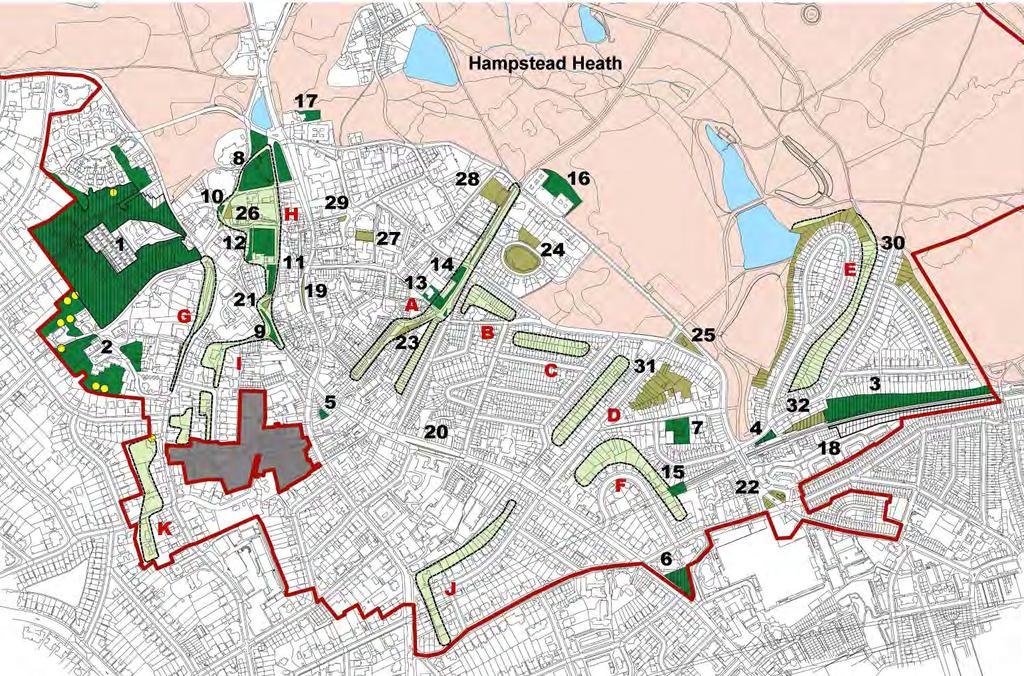
30 Policy NE1: Local Green Spaces 4.3 National planning policy (NPPF 76-78) states that local communities, through local and neighbourhood plans, should be able to identify for special protection green areas of particular importance to the community for their beauty, historical importance, richness of wildlife or recreational value, introducing a new Local Green Space (LGS) designation. Local policy for managing development within a LGS should be consistent with policy for Green Belts. Policy NE1: Local Green Spaces 1. Local Green Spaces (LGS) will be fully protected in accordance with the NPPF. 2. To achieve this, the plan resists development of any kind that causes harm to the Local Green Spaces. 3. The following sites are designated Local Green Spaces: Branch Hill House Site of Importance for Nature Conservation and two additional areas Oak Hill Park South End Green Mansfield Allotments World Peace Garden, South Hill Park Heath Hurst Gardens Oriel Place Garden Hampstead Green Keats House and Garden Holly Hill Upper Terrace Reservoir Upper Terrace Green Triangle Fenton House Gardens Pedestrian walk from Admirals Walk to Windmill Hill Burgh House Gardens Gertrude Jekyll s Garden and Communal Gardens of Wells House Garden of The Pryors Garden of Whitestone House 4. Spaces with existing protected designations not in the list above, such as Hampstead Heath, Camden-designated Public and Private Open Spaces and Sites of Importance for Nature Conservation, are also considered important local spaces and are shown in the Open Space Appendix 4. Hampstead Neighbourhood Plan March 2017 DRAFT FOR CONSULTATION 29
31 4.4 The sites in the Hampstead Neighbourhood Area listed above, (see Map 5 and Appendix 4) are to be designated as LGSs as defined in NPPF 77. Each of these sites comply with the criteria that they are in close proximity to the community they serve, are local in character and not extensive, and are capable of enduring beyond the end of the Plan period. A full list of designated LGSs is given in the Appendix 5 with evidence to support the designations. 4.5 There are a number of organisations who manage these Local Green Spaces such as the London Borough of Camden, Wells and Campden Trust, Thames Water, British Rail and other organisations. 4.6 The Plan recognises the value of the existing green and open spaces on social housing and private estates and for residential blocks in the Hampstead Neighbourhood Area, and wishes to ensure adequate provision of open space for residents. The Plan acknowledges the potential benefits that can be gained through estate regeneration schemes, but suggests these benefits be weighed against any loss of open space when planning applications are assessed. 4.7 As part of any planning application for development within or immediately adjacent to a LGS, developers should demonstrate how the LGS will be protected from the impact of the proposed development and its construction, and how the landscaping, amenity and biodiversity of the area will be preserved or enhanced (see also Policy NE2). 4.8 The Hampstead Conservation Area Appraisal and Management Strategy (Hampstead Conservation Area Statement 2002) sets forth a list of policies concerning areas that fringe the Heath. The Plan supports Heath Fringe policy HF3 which seeks to control development along roads leading to the Heath and in the gardens and trees adjacent to the Heath so as to safeguard their present contribution to the setting of the Heath. Such areas would include the gardens of Upper Terrace House, The Heights, Foley House and Squire Mount House. Hampstead Neighbourhood Plan March 2017 DRAFT FOR CONSULTATION 30
32 Policy NE2: Trees 4.10 Trees have an important role to play in climate change mitigation. Tree canopies slow the movement of rain to the ground thus reducing surface runoff and sharp increases in groundwater flow during and following heavy storms. This is especially important in Hampstead because of its hydrogeology and the risk of flooding from surface run-off, particularly for houses located towards the bottom of slopes The main tree species that define our area include the taller limes, London planes, oaks, willows, black and Lombardy poplars, beech, horse chestnut and Scots pine, most of which take several decades to reach maturity Importantly, the Plan area is home to numerous veteran trees, already shown as significant trees on the Ordinance Survey Map of 1866: the Heath has many hundreds; some oaks more than 500 years old. Others can be found in the front and rear gardens around the Heath despite 19th-21st century development (see Appendix 6 Veteran Trees). The origin of many of these can be traced back to historic hedges and boundaries. It is vital for biodiversity that they continue to retain physical links to the veteran hedgerow trees on the Heath Other important trees in the areas were planted for aesthetic reasons, to line streets for example, or for practical purposes, to soak up water in boggy gardens An initial list of Important Trees in the Plan area, appears on the HNF website. This is a list of trees chosen for their aesthetic and/or environmental or historic value by local people. See Important Tree list, Appendix 6. Hampstead Neighbourhood Plan March 2017 DRAFT FOR CONSULTATION 31
33 Policy NE2: Trees Development will protect trees that are important to local character, streetscape, biodiversity and the environment. 1. Any development that proposes removal of a tree on the Locally Important Tree list should provide justification for the proposed tree removal(s) and details of replacement tree planting to mitigate against the loss of canopy cover, included within the application. Any trees removed to facilitate development shall be replaced by trees of a large [15m+] ultimate size where the site allows. 2. Planning proposals are required to ensure that veteran trees are fully and strictly protected in accordance with Natural England's Standing Advice for Ancient Woodland and Veteran Trees. Root protection zones of veteran trees will be at least 15 metres radius for each tree, deadwood should be retained where possible. Canopy reduction to facilitate construction will only be acceptable in exceptional circumstances. 3. If a tree replacement enforcement notice is in place, the proposed development must allow for the trees replacement. 4. Tree root protection for veteran trees should provide for any likely activities that may occur during construction. 5. Where there are no existing trees on a site, development should allow space for the future planting of trees well suited to local conditions, as noted above Robust justification would need to show that the loss of the tree would be justified by public interest The main tree species that define our area (as identified by paragraph 4.11 above) would be appropriate choices for replacement trees New residential and commercial development proposals where trees > 7.5cm in trunk diameter at 1.5m from ground and >1.5m in height are present (on site or off-site trees of which have root protection areas that encroach onto the application site or could be affected by development in any other way) are to be accompanied by a tree survey, arboricultural impact assessment, tree protection plan and an aboricultural method statement. Hampstead Neighbourhood Plan March 2017 DRAFT FOR CONSULTATION 32
34 Veteran trees 4.18 The root protection zones of veteran trees or existing trees specifically marked on the 1866 OS map will be protected as determined for veteran trees by Natural England: 'Standing Advice for Ancient Woodland and Veteran Trees' Where veteran trees or trees specifically marked on the 1866 OS map are present on site or within 15 metres of the site boundary, development or demolition proposals will be required to be implemented in accordance with specialist guidance provided by an arboriculturalist with veteran tree expertise in order to ensure the protection and survival of the trees. Guidance should also be sought from veteran tree experts of the Corporation of London, Hampstead Heath, who have offered to provide such guidance Protection for veteran trees, particularly where compaction is a risk, must include a ground protection system that is fit for purpose Landscaping proposals should have regard to the prevailing and historic pattern and extent of tree cover and landscaping. Site Protection of trees during construction 4.22 All street trees near to the application site shall be protected from damage in line with BS5837:2012, including all potential heavy vehicle movements In order to preserve tree canopy, the piling rig offering the lowest clearance possible should be utilised when working under the canopies of trees to minimise both potential damage and the need for access facilitation pruning. Hampstead Neighbourhood Plan March 2017 DRAFT FOR CONSULTATION 33
35 Policy NE3: Ecological Networks 4.25 Each garden can contribute to biodiversity. Some features such as tree lines or boundary hedges however are shared by several gardens. Many wildlife species need to be able to travel to reach other areas of habitat for food or refuge or to balance their population. Ecological corridors and stepping stones are defined in The Natural Environment White Paper: 'Making Space for Nature' (2011) Section 2.12 as areas "enabling species to move between core areas, these can be made up of a number of small sites acting as stepping stones or a mosaic of habitats that allows species to move and supports ecosystem functions...more, bigger, better and joined." 4.26 Hampstead's connections with three of London's strategic green corridors, Hampstead Ridge, Nash Ramblers Link, and North London Line Link, means that connectivity both between these strategic green corridors and within itself is essential. Network connections are strengthened by an increase in green ground cover and biodiversity in general, and canopy continuity along tree lines and boundaries Tree canopy lines, veteran trees, ancient hedgerows and our network of green spaces form an important habitat for birds, bats and other species. As recognised in the London Plan they are also important for humans. Hampstead Neighbourhood Plan March 2017 DRAFT FOR CONSULTATION 34
36 Policy NE3: Ecological Networks 1. The Plan requires development to protect and assist in the restoration of Hampstead's tree lines and green corridors, reducing the incidents of breaks and the length of gaps. 2. The following sites are designated Green Biodiversity Corridors. Please refer to Map 4 above and Appendix 4. A. Site of historic hedgerow around South Hill Park & South Hill Park Gardens. B. Site of historic hedgerow around Hampstead Hill Gardens. C. Site of historic hedgerow between Downshire Hill and Pilgrims Lane. D. Rear garden boundary line between Willow Road and Denning Road. E. Green corridor and old orchard behind Christchurch Hill. F. Historic line of lime trees in Well Walk. G. Historic line of lime trees: Flask Walk H. Historic line of lime trees: Hampstead Grove, Admirals Walk & Lower Terrace I. Shrubbery Frognal 3. Proposals for property that include part of the above should not harm the existing ecological network. 4. Subject to their scale and location, proposals should establish the quality of the existing biodiversity through relevant ecological appraisal and species surveys. Proposals should seek to enhance biodiversity accordingly through the scheme design. Hampstead Neighbourhood Plan March 2017 DRAFT FOR CONSULTATION 35
37 Policy NE4: Supporting biodiversity 4.28 In order to minimise the impact of development on biodiversity, development will not be supported that diminishes biodiversity or the effectiveness of ecological networks: wild corridors and the stepping stones that connect them. Policy NE4: Supporting biodiversity 1. In order to enhance biodiversity, development proposals will be encouraged to: a. Use restrained exterior lighting in low blue content white or yellow light only. b. Increase canopy cover as part of any landscaping scheme. c. Increase the area of permeable surface 2. Development proposals should seek to: a. Maintain, expand or enhance designated nature conservation sites and designated Green Biodiversity Corridors; b. Protect or enhance the status or population of priority habitats and species The Plan will support proposals for restoring front and back gardens, introducing biodiversity measures, replacing gaps in tree lines and increasing soft landscaping. The Royal Horticultural Society suggests numerous ways to increase biodiversity in private gardens A wide body of evidence suggests that blue-rich white outdoor lighting is detrimental to the ecosystem, to the enjoyment of the night sky, to astronomical research and possibly to human health. See Appendix 1, Evidence Base, for more information. Hampstead Neighbourhood Plan March 2017 DRAFT FOR CONSULTATION 36

38 5. Basement Policies Hampstead Neighbourhood Plan March 2017 DRAFT FOR CONSULTATION 37

. This policy seeks to ensure that full consideration is given to the potential impacts of basement developments at application stage. 5.")
39 5. Basement Policies Introduction 5.1 These policies apply to all new basement development. Basement development is defined as the construction or extension of one or more storeys of accommodation below the prevailing ground level of a site or property. 5.2 Surveys among residents have resolutely identified this as being of considerable concern within the community and the evidence we gathered justifies these concerns (see Basement evidence folder, damage caused by basement construction). This policy seeks to ensure that full consideration is given to the potential impacts of basement developments at application stage. 5.3 Basement extensions can provide an opportunity to add space to homes in parts of the Borough. However, Hampstead has a unique set of conditions that mean basement construction can inflict structural damage and/or trigger flood risks on susceptible neighbouring properties. These unique circumstances are summarised below. Geography and topography 5.4 Hampstead is set on one of the largest and highest hills in London, with the highest rainfall of the Greater London area, and much of it located on the flank of that large hill. As a consequence, a significant number of Hampstead streets are downward sloping, where hard standing or building footprint enlargement produces additional surface run-off and drainage requirement, increasing flood risk in storm periods to vulnerable lower areas such as South End Green/Fleet Road and West Hampstead. Flooding in South End Road, Hampstead Neighbourhood Plan March 2017 DRAFT FOR CONSULTATION 38
40 Geology and hydrology 5.5 Hampstead is a complex layering of Bagshot Sand, Claygate Member and band D of the London Clay Formation. The top two layers have a high silt and sandy component rendering them susceptible to high water conductivity, as well as being potentially less stable; even band D of the London Clay Formation, while less permeable, still has a variable but significant silt content with a degree of erodability, and can contain water under pressure in sand partings. In parts of Hampstead the 'water table' ground water flow across the top of both the Claygate Beds and band D of the London Clay Formation can be seen - at the bottom of wells - to be constant and rapid. Basement excavation can sometimes break into continuous flow of these water tables, but also will constrain and divert the ground water present throughout the area, causing erosion of the high silt and sand content of Hampstead's soil types leading to significant volume loss. This results in the frequent subsidence of neighbouring buildings and formation of cavities under roadways and services. 5.6 When this leads to mains pipe collapse this compounds the problem of silt erosion/wash-out, leading to significantly large sink holes.there is also a need to reduce the incidence of garden ponding and tree drowning in Hampstead following damming up of ground water by neighbouring basements. 5.7 Much of the area has been identified as an area of significant landslide potential, with variable susceptibility from the pressure changes of cutting into the hillside. Constraint and diversion of ground water and the local underground streams by basement construction can contribute to the lubrication of landslip on even gentle slopes, such as occurred to St Stephen's Rosslyn Hill from the construction of the Royal Free Hospital's underground car park in the 1970 s, which cost millions to rectify. Adequate testing is particularly vital in Hampstead to inform the Basement Impact Assessment and reduce the risk of unexpected and serious damage to development projects and to the surrounding neighbours. Architecture 5.8 A substantial part of the neighbourhood plan area constitutes rows of terraced Victorian townhouses with shallow foundations, one of the riskiest situations in which to construct a basement, according to Arup in the Eatherley decision. Because the property shares its existing foundations with its neighbours and also because it provides lateral support to its neighbours, any movement of the existing house resulting from the works will directly impact on its neighbours. There are also a significant number of narrow streets in some areas. 5.9 Further, the construction of basements can give rise to noise and disturbance during construction, and the management of traffic, plant and equipment. The policies set out below seek to address these concerns and provide a clear Hampstead Neighbourhood Plan March 2017 DRAFT FOR CONSULTATION 39
41 policy framework for proposals for basement development within the Neighbourhood Plan area Creating extra footage through basement development does not support the Plan s Policy CO2 of maintaining a reasonable balance of both large and small dwelling units. Hampstead Neighbourhood Plan March 2017 DRAFT FOR CONSULTATION 40


42 MAP 6 Hampstead geology Hampstead is made of a complex layering of bagshot sand, claygate member and London Clay, which makes the area potentially less stable. Plan area is outlined in red. MAP 7 Hampstead topography Hampstead is situated on a steep slope with a drop in elevation of 73 metres from Jack Straw s Castle to South End Green. Plan area is outlined in red. Hampstead Neighbourhood Plan March 2017 DRAFT FOR CONSULTATION 41
43 Policy BA1: Basements 5.11 Restrictions on the extent and scale of basement developments can prevent the adverse effects identified above. Policy A5 of the Camden Local Plan seeks to restrict the extent and scale of basement development accordingly. Camden Planning Guidance 4 Basements and Lightwells establishes further requirements for applicants to adhere to in relation to proposals for basement developments, including the need for assessing the proposed impacts of basement developments, considering impacts to neighbours from demolition and construction, and links with other regulatory regimes and requirements. The requirement in the policy below that basement developments under the garden should be less than 50% of the footprint of the house seeks to clarify policy A5 of the Local Plan Basement development and other development which involves excavation changes the ground and water conditions of the area which can potentially lead to ground instability, flooding or detrimental effects on trees This plan seeks to protect the environment and adjoining neighbours properties and buildings from these impacts. Policy BA1: Basement Development 1. Proposals for basement development in Hampstead will be required to demonstrate how they will not cause harm to: a. nearby properties and trees; b. structural, ground or water conditions; c. the character and amenity of the area or building; and d. the significance of heritage assets. 2. All proposals for basement development must aim for Burland Scale 0 ( negligible ) and in worst circumstances must demonstrate how the risk of damage to properties, caused by construction and/or engineering work (s) and/or subsidence resulting from the proposed development, is predicted to be no higher than one ( very slight ) on the Burland Scale following the implementation of any mitigation measures. 3. Basement developments beyond the footprint of the house should be less than 50% of the footprint of the house. 4. For rear boundaries where there are visually important, mature or veteran trees, historic tree lines or a green corridor, a minimum boundary of 15 metres should be provided. Hampstead Neighbourhood Plan March 2017 DRAFT FOR CONSULTATION 42


44 5.14 The Plan strongly advises developers to liaise with neighbours before the start of the project and maintain communication throughout the works. Where preconsultation has taken place, this information should be included with the planning application. Evidence of groundwater diversion and erosion in New End and Heath Street Hampstead Neighbourhood Plan March 2017 DRAFT FOR CONSULTATION 43
45 Policy BA2: Local Requirements for Basement Impact Assessments 5.15 Because of the unusual and unstable soils found in Hampstead, as noted in Camden Local Plan 6.132, basements in Hampstead may pose a particular risk to neighbouring properties and require additional investigations, above those required by the Local Borough of Camden, to insure that risks can be identified and damage mitigated at the planning stage. Policy BA2: Local Requirements for Basement Impact Assessments 1. Additional steps for the Basement Impact Assessment, as outlined below in paragraphs 5.16, 5.17 and 5.18, will be required for any basement development where it is reasonable for an engineer, geotechnical professional or geologist to be commissioned by the applicant, the neighbour(s) or Camden in order to assess or comment on the proposed development. 2. Planning applications for these basements will be required to provide a Schedule of Condition survey of neighbours properties up to a distance of twice the depth of the basement from the point of excavation (the zone of influence). 3. A section 106 agreement must be issued and include, as a condition, that the Construction Management Statement will not be approved by the Council without attached signed and agreed Party wall agreements, if applicable, with neighbours Applications for basements where the involvement of an engineer and/or geotechnical professional and/or geologist has been commissioned or is expected to be commissioned by the applicant, the neighbour(s) or Camden, must include, upon the initial submission of the application, additional steps for Basement Impact Assessment, to be produced by a Chartered Civil Engineer (MICE) or Chartered Structural Engineer (MR Instruct. E) with experience in basement construction In addition to the standard requirements, the BIA will need to take these additional steps: a. Hydrological borehole measurements to sample soil near boundaries with neighbours to a depth of at least 6m should be conducted in periods of contrasting rainfall and over a period of no less than 6 months (ref CPG4 and paragraphs 291 to 294 of the Camden Geological, Hydrogeological and Hampstead Neighbourhood Plan March 2017 DRAFT FOR CONSULTATION 44
46 Hydrological Study) with meteorological data to establish a realistic model of existing ground water regime as can be found at NW3Weather.co.uk. b. An automatic log water measurements recorder left activated in the boreholes over a sustained period of contrasting rain cycles to demonstrate local groundwater and water table levels and the local extent of groundwater surges during and immediately following storms. c. An assessment demonstrating that the predicted Burland Scale at the time of the construction phase is no more than Burland Scale 1 throughout the building and that of each neighbouring building that has any part within the zone of influence. The assessment must show the location of the predicted impact and also demonstrates that the methodology and supporting engineering calculations stand to scrutiny. d. An assessment of current ground and geology conditions; topology; groundwater levels. This should include details of the structure and foundations of the existing building, and neighbouring properties. e. Flooding and ground reports of both the applicant s and the neighbouring properties. f. The location and distance of the property to areas identified as flood risk in the Strategic Flood Risk Assessment prepared for Camden by URS in July g. Cross section of ground geology should be reported and drawn through comprehensive cross sections, reports and graphs. h. A detailed construction sequence and design, produced by a suitably qualified engineer, including the relationship between permanent and temporary works and how vertical and lateral loads are to be supported. i. Hydrological modelling to show whether it will be possible through the inclusion of drainage systems to prevent any significant harm from changes to groundwater levels or flow The engineering design should be advanced to Detailed Proposals Stage (equivalent to RIBA stage D) as set out in the Services of ACE (Association of Consultancy and Engineering) Agreement 1: Design, 2009 Edition). Appropriate drawings must be prepared and submitted that illustrate how the construction addresses the following: a. groundwater and groundwater surges where present during storms b. drainage c. flooding d. vertical and lateral loads e. movements f. ground conditions g. vaults h. existing and adjoining buildings and structures i. overall stability Hampstead Neighbourhood Plan March 2017 DRAFT FOR CONSULTATION 45
")
47 5.19 The Plan sites a wide body of evidence showing that significant damage from basement development has occurred in the area and continues to occur; therefore, all issues related to the BIA or raised by the Independent Assessor appointed by Camden must be resolved to the fullest extent possible prior to determination of the planning application rather than being deferred as a condition(s) included in a Section 106 agreement. Cracked window frame and emergency structural support at 92 South Hill Park, caused by basement development next door Hampstead Neighbourhood Plan March 2017 DRAFT FOR CONSULTATION 46
48 Policy BA3: Construction impacts 5.20 Construction impact is a major cause of public concern in relation to basement development. In the Camden Basement Evidence Report of February 2016, more than half of the respondents said that they thought the impacts on noise, vibration, and dust were unacceptable, with just under half of the respondents also stating they thought the impacts on traffic and parking were unacceptable The impact of construction is further exacerbated when there is more than one basement development in close proximity or in the same street. The main construction impacts relate to construction traffic, parking suspensions, noise, vibration and dust. Policy BA3: Construction impacts 1. Proposals for basement development must demonstrate: a. that disturbance arising from construction, including that arising from construction traffic, parking suspensions and the noise, dust and vibration of construction itself, must be kept to acceptable levels, taking into account the cumulative impacts of other development proposals. b. that traffic and construction activity will not cause unacceptable harm or inconvenience to pedestrians, cyclists, or vehicles in terms of safety or congestion. c. how the construction will not unreasonably inconvenience the day to day life of those living, working and visiting nearby. d. Prior to the commencement of works a condition of the planning consent will be that the cost of repair(s) of damages caused by the basement construction(s) that are not covered by the Party Wall legislation, will have to be underwritten by the applicant. The condition will have to be worded so as to explicitly stipulate that the applicant will be legally bound through a section 106, or other conditions, to commit to fully compensate the affected residents for their reasonable costs towards the cost of repairs of the damages they suffer as a direct result of the basement work(s). Hampstead Neighbourhood Plan March 2017 DRAFT FOR CONSULTATION 47
49 5.22 Applicants should address all the processes involved in the construction of their basement and describe mitigation measures to be used to keep noise, vibration and dust to acceptable levels under the relevant Acts and guidance (including the Control of Pollution Act (COPA) 1974, Environmental Protection Act 1990, the Noise Emission in the Environment by Equipment for use Outdoors Regulations 2001, and BS : 2009: Code of practice for noise and vibration control on construction and open site). The more complex the proposed basements, the more detailed the levels of information should be provided at the application stage Where a Construction Management Plan (CMP) is a condition of planning consent, this plan should be submitted, and must be approved by the LPA, prior to the commencement of works or as required by the condition. A CMP is used toohelp developers to minimise construction impacts, and relates to both on site activity and the transport arrangements for vehicles servicing the site. It differs from the CMS referred to in policy B2 which seeks to ensure that the construction of the basement can be undertaken safely and will safeguard the structural stability of the existing building and other nearby buildings The conditions should require planned works to be limited to 8am-6pm on Mondays to Fridays only. High Impact Activities will be restricted to 9am-noon and 2pm-5.30pm on weekdays. At no time should there be any works on Saturdays, Sundays or public holidays. High Impact Activities include: a. Demolition, ground-breaking and excavation works using percussive equipment; b. Percussive piling operations and percussive pile reduction and pile breakout works; c. Percussive and grinding power tools on party walls/floors of adjoining occupied properties. Hampstead Neighbourhood Plan March 2017 DRAFT FOR CONSULTATION 48


50 6. Traffic and Transport Hampstead Neighbourhood Plan March 2017 DRAFT FOR CONSULTATION 49
51 6. Traffic and transport Introduction 6.1 Traffic congestion and associated vehicle emissions are key concerns in the Plan Area, with levels of Nitrogen Dioxide (NO 2 ) pollution in many of our residential roads, reaching levels which are substantially above national & EU objectives. In view of the risk to the public, the London Borough of Camden has been designated an Air Quality Management Area (AQMA) for NO 2 pollution and has developed an Air Quality Action Plan (AQAP). 6.2 The AQAP encapsulates the Mayor s Transport Strategy and Camden s Transport Strategy 2011, whose first objective is to reduce motor traffic and vehicle emissions. In Greater London as a whole, road traffic is responsible for about half of all NO 2 pollution. 6.3 The strength of local feeling on matters of congestion and pollution is reflected in the fact that these issues received the third largest number of written comments during community consultation. 6.4 It is important to note that the community s ability to control traffic congestion and vehicle emissions through the planning process is limited and a number of the busiest roads in the Plan area are part of the TfL road network, whose management is outside the control of Camden Council. 6.5 National Planning Policy (NPPF paragraph 124) nevertheless requires the planning process to sustain compliance with national and EU objectives for pollutants, taking into account the cumulative impact of development on air quality, and to ensure that new development is consistent with Camden s AQAP. 6.6 The Neighbourhood Plan therefore provides supporting development policies where consistent with these objectives in the context of the Plan area followed by guidance on relevant strategies which lie outside the remit of planning policy, but which are nevertheless important to the local community and to the sustainability of the neighbourhood. These include the community s vision for the South End Green Neighbourhood Centre. 6.7 In line with National Planning Policy (NPPF paragraphs 15 and 16), the Neighbourhood Plan is designed to provide clear policies which support sustainable development in the Plan area that is outside the strategic elements of the draft Local Plan. The Forum considers that clear definitions and policies can play an important role in supporting development by giving Hampstead Neighbourhood Plan March 2017 DRAFT FOR CONSULTATION 50
52 both developers and the community the confidence to make appropriate decisions. To this end the Plan s transport policies incorporate the following simple definitions to indicate where individual transport policies should and should not apply: a. Heavy goods vehicles are defined as vehicles over 7.5 tonnes unladen weight in line with Camden s Planning Guidance 7 b. Large developments involving a gross internal area above 300m 2 (the equivalent of three large 3-bedroom houses as shown in the government s Nationally Described Space Standard issued in March 2015) are regarded as requiring especial care to manage service and construction traffic in the context of the Plan area. c. A public transport accessibility level (PTAL) score over 5 (slightly below the borough average of 5.6) is defined as the minimum level for the sites of large developments, schools and educational institutions in the Plan area. d. In the context of the Plan area, developments involving a reasonable expectation of an additional 50 or more person trips per day (equivalent to the total number of trips generated by a single practitioner dental surgery) are defined as requiring especial care to ensure that their transport impact is assessed and appropriately managed.. Traffic and Pollution 6.8 Hampstead village is dominated by the A502 London Distributor Road, which runs through its centre and along a narrow and frequently congested section towards Whitestone Pond. The B511 and B519 Borough Distributor roads running along Fitzjohn s Avenue and Spaniards Road suffer frequent congestion. Roads leading to South End Green are heavily used and Fleet Road suffers from stationary or slow moving traffic during most daytime hours. The community have expressed particular concern about the wide catchments of some local schools, resulting in high volumes of traffic coming from outside the Plan area, causing chronic congestion at peak times. 6.9 Community responses indicate a high level of support for measures to reduce traffic congestion and encourage use of sustainable transport Our pollution study revealed high levels of air pollution. Only in a few areas such as the middle of Hampstead Heath did the level of Nitrogen Dioxide (NO2) fall well below limits set by the EU. The highest level of NO2, more than twice the EU limit, was recorded at the junction of Arkwright Road/Fitzjohn s Avenue and at Spaniards Inn High pollution levels have contributed to the fact that over half of the Plan area, when assessed against a measure of Living Environment Deprivation Hampstead Neighbourhood Plan March 2017 DRAFT FOR CONSULTATION 51
53 fell within the 20% most deprived areas of England in Camden Council s Hampstead Area Profile shows that the Plan area s deprivation score has worsened since Responses during community engagement indicate particular concern over the harm done by large construction and delivery vehicles. In addition to noise, these vehicles cause physical damage to the surfaces of roads and pavements, and clog up narrow streets, impeding the free movement of traffic and frustrating pedestrians and other road users. The Forum considers a development size of 300m 2 gross internal area be a reasonable threshold, above which special care is required to manage service and construction vehicles so as to avoid undue impact on the Plan area. Having reviewed the various vehicle categories, the Forum has concluded that a vehicle size of 7.5 tonnes unladen weight is the maximum which is desirable, given the Area s complex street pattern and many width restrictions The Plan recognises that the area immediately surrounding a development site is not the sole consideration in assessing transport impact because additional vehicle traffic will necessarily have to move across other streets in the Plan area (the vast majority of which are residential) in addition to the street on which development is taking place Where vehicles are used for servicing and delivery it is important that their impact is considered at an early stage. The following areas are responsible for most impact, but are not included in the required content for the Council s Transport Assessment set out in Camden Planning Guidance 7, meaning that submission of this information separately or through a Servicing and Delivery Plan may be necessary to ensure that servicing and delivery requirements are given due consideration :- a. Scheduling of deliveries and service visits b. Proposed location for vehicles during loading/unloading. c. Size and height of vehicles d. Planned waiting times e. Loading and unloading requirements, including numbers of operators and the need for additional kerbside space for pallets and machinery As road capacity cannot be increased within the Plan area and as traffic congestion and vehicle emissions are already well above acceptable levels, the transport sustainability objectives set out in National Planning Policy (NPPF) and the AQAP can only be achieved by a net year-on-year decrease in the use of motor vehicles. Policy T2 of Camden s draft Local Plan proposes that all new development in the Borough will be car-free All applicants are therefore encouraged to consider creative solutions which will avoid increases in motor vehicle traffic and thereby promote economic, social and environmental sustainability. Hampstead Neighbourhood Plan March 2017 DRAFT FOR CONSULTATION 52
 where adverse impacts")


54 6.17 Inevitably, some developments which offer over-riding benefits on other grounds may have the effect of increasing motor traffic at a specific location. Given the critical importance of reducing pollution and congestion levels (and in line with National Planning Policy (NPPF paragraph 152) where adverse impacts are unavoidable, and all reasonable mitigation has been provided, it may be necessary to offset any increase through other measures so that a development does not lead to an overall increase in traffic volumes within the Plan area To this end, where an increase in vehicle traffic is unavoidable and cannot otherwise be mitigated, then public realm or public transport improvements which aim to achieve corresponding reductions in vehicle usage elsewhere in the Plan area should be delivered through the use of planning obligations, so that development does not lead to a net increase in motor vehicle usage. Pedestrians and buses try to get through congested traffic on the A502 London Distributor Road in the centre of Hampstead Service Delivery vehicles on Heath St. Traffic congestion in Fitzjohn s Avenue/Arkwright Road 6.19 In line with Camden s Planning Guidance 7 Transport, the Forum has concluded that the measure of person trips should be used as the starting point to assess transport impact and that an expectation of 50 new person trips per day represents a significant threshold, given the specific context of the Plan area, above which especial care is required to manage the transport impact of a proposal. Hampstead Neighbourhood Plan March 2017 DRAFT FOR CONSULTATION 53
55 Policy TT1: Traffic Volumes & Vehicle Size Policy TT1: Traffic Volumes and Vehicle Size The following policy applies as an extension to the provisions of the draft Local Plan to ensure that developments are sustainable given the exceptional traffic challenges present in the Plan area: 1. Planning applications which can reasonably be expected to result in an average of 50 or more new person-trips per day post-completion must meet the following needs: a. A Transport Assessment (or Statement) should be provided and approved before development proceeds. b. The Transport Assessment (or Statement) should demonstrate that approval could not reasonably be expected to lead to a net increase in motor traffic or vehicle pollution (other than for servicing or delivery) in the Plan area post completion. 2. Planning applications whose delivery and servicing requirements will result in additional vehicle movements post completion must meet the following needs : a. A Delivery and Servicing Management Plan (DSMP) should be provided and agreed before the relevant planning application is approved. b. The DSMP should demonstrate (if necessary through mitigating measures) that approval could not reasonably be expected to lead to an increase in traffic congestion or significant loss of amenity to occupiers and neighbours. 3. In addition to the guidance contained in Camden Planning Guidance 6 Amenity, basement excavations and all developments of over 300 m 2 gross internal area must be accompanied by a full or outline Construction Management Plan (CMP), which should be agreed before the relevant planning application is approved. 4. To reflect the street pattern of the Plan area, any DSMP or CMP should be implemented through the use of vehicles of no more than 7.5 tonnes unladen weight, other than in circumstances where this is not feasible and such exceptions must be documented within the relevant plan. Hampstead Neighbourhood Plan March 2017 DRAFT FOR CONSULTATION 54
56 Policy TT1: Traffic Volumes and Vehicle Size (continued) 5. Given the critical need to reduce vehicle emissions in the Plan area any significant measures proposed to mitigate or offset potential increases in motor traffic so as to secure compliance with this Policy TT1 should be implemented through the use of planning conditions or obligations. 6. In line with National Planning Policy (NPPF Annex 2), where a Travel Plan approved in connection with an application entails significant measures to mitigate or offset its transport impact, an annual monitoring report demonstrating its effectiveness should be provided to the Council for the first five years following construction 6.1 Comprehensive guidance on Transport Assessments, Transport Statements and Delivery and Servicing Plans can be found in Camden Planning Guidance 7 Transport. Guidance on Transport Statements can also be found in Camden Development Policies 2010 paragraph It should be noted that Transport Assessments, Transport Statements and Servicing & Delivery Plans, while being essential planning tools, should not be burdensome and need only be proportionate to the scale of development. They are a tool to ensure that potential transport impacts of a planning application are given appropriate consideration. In line with National Planning Policy (NPPF 193) they need only contain information which is relevant, necessary and material to the application in question. 6.3 The depth of analysis required should reflect the scale of a development and the extent of its impact on local transport capacity and local amenity. 6.4 It should be noted that paragraph 1 of Policy TT1 is concerned with new person trips and its objective is to prevent additional vehicle traffic and pollution. Therefore, if an existing premises are refurbished or redeveloped in a way which does not add 50 or more person-trips per day, then this paragraph will not apply. 6.5 Further guidance on Construction Management Plans can be found in Camden Planning Guidance 6 Amenity. To ensure that the practical impact of development is considered as early as possible the Plan strongly encourages the submission of a full CMP during pre-planning. Where an outline CMP is provided it should contain sufficient information to confirm that the material impacts of construction on the transport system and on the amenity of neighbours have been appropriately considered and mitigated. Hampstead Neighbourhood Plan March 2017 DRAFT FOR CONSULTATION 55
57 6.6 Where a Transport Assessment, Transport Statement, DSMP or CMP is required, and in line with NPPF paragraph 189, the Council should take into account evidence provided to it that the applicant has consulted the local community affected by the development and has taken their reasonable concerns regarding any potential harm to the area into account. 6.7 Improvements by TfL and Camden Council to discourage through traffic entering the Plan area are strongly supported, including: a. Downgrading of the A502 London Distributor Road given its unsuitability for heavy vehicles north of Hampstead village. b. Use of local traffic only signs at key entry points to discourage traffic from entering the Plan area where more appropriate choices, such as the A41 Finchley Road are available. Hampstead Neighbourhood Plan March 2017 DRAFT FOR CONSULTATION 56
58 Policy TT2: Pedestrian Environments 6.8 Hampstead Village and South End Green offer village and neighbourhood environments which attract large and growing numbers of visitors. The commercial, social and environmental health of these centres is heavily dependent on footfall and the maintenance of a pleasant and welcoming experience for pedestrians. Visitors do not follow linear paths and frequently wish to browse and move from one side of the road to the other. 6.9 However, traffic and pollution often makes walking unpleasant and unhealthy. The sustainability of Hampstead Village and South End Green depend on measures to protect their historic character while maintaining high levels of permeability, improving driver behaviour and avoiding concentrations of pedestrians at specific crossing points, so that pedestrians and shoppers feel they are able to cross the streets freely and safely Applicants are therefore encouraged to consider solutions which support economic, social and environmental sustainability across the Plan area by creating a more welcoming environment for pedestrians and cyclists while promoting their vibrancy and historic character. Policy TT2: Pedestrian Environments In the context of the Plan area, public realm improvement works supported by development should be consistent with the following objectives to: a. Promote the permeability of roads, alleys and courtyards (i.e. they are easy to walk or cycle through). b. Protect or complement the historic character and charm of the area s streets, pavements and sightlines. c. Support the borough-wide 20mph speed limit d. Avoid unnecessary street furniture, signage and segregation. e. Provide increased numbers of crossing points which have aesthetic appeal, are pleasant for pedestrians to use and promote safety by encouraging road users to regard the street as a shared space and hence be mindful of others. f. Avoid unnecessary barriers, width restrictions, build-outs, islands and management measures, which detract from the area s historic character or are likely to worsen rather than reduce street congestion. g. Provide appropriate opportunities for on-street cycle parking and, where appropriate street cycle rental. Hampstead Neighbourhood Plan March 2017 DRAFT FOR CONSULTATION 57
59 6.11 Policy T1 of the Camden draft Local Plan seeks to ensure that developments improve the pedestrian environment by supporting high quality public realm improvement works and the provision of high quality safe road crossings where needed Implementation of Camden Council s Naked Streets Principle set out in its Transport Strategy 2011, including removal of unnecessary street furniture, signs, signals and obstacles is strongly supported. This in turn can result in lower traffic speeds and a safer and more pedestrian-friendly environment Where it is necessary to introduce traffic calming, deployment of additional crossing points and enforcement of the 20mph speed limit should be considered as a first-line measure in preference to the use of barriers, signs, furniture and segregation Department for Transport statistics for 2014 show that serious injuries and deaths to pedestrians at zebra crossings in the UK are half those of controlled (pelican/puffin) crossing types, despite the fact that the numbers of zebra and controlled crossings are similar. TfL s report Collision Levels in Greater London shows that the numbers of zebra and controlled crossings in Greater London are equivalent. This safety benefit appears to result from two factors: a. Greater use of zebra crossings in areas where speed limits are 20mph or less. b. The tendency for drivers at controlled crossings to look only at the traffic light (so that they are often unaware of pedestrians and cyclists) compared with the need to actively scan for other road users when approaching a zebra crossing In view of their safety and aesthetic benefits and given the enforcement of a 20mph zone throughout Camden, the use of zebra crossings is encouraged as the first-line option for pedestrian crossings within the Plan area Shared Use Road Schemes (generally a kerb-free single surface, with pedestrian areas distinguished by visual and tactile lines) involve a high cost, but community engagement indicates such a scheme would be welcomed for South End Green provided implementation did not detract from the character of the area Measures to promote a similar awareness of shared space through additional crossing points and a reduction in street furniture are strongly supported, so that motorists are encouraged to be more vigilant. Responses received during community engagement indicated a desire to increase the number of pedestrian crossing points on various roads, including Fitzjohn s Avenue. Hampstead Neighbourhood Plan March 2017 DRAFT FOR CONSULTATION 58
60 Policy TT3: Public Transport 6.18 A widely recognised way to measure connectivity to the public transport network in London is the PTAL (Public Transport Accessibility Level) system, adopted by Transport for London as the standard method to calculate access to public transport. The PTAL value combines information about how close public transport is to a location and how frequent the service is. The highest level of connectivity has a PTAL of 6b (excellent) and the lowest has a PTAL of 0 (very poor). 50% Percentage of People at each PTAL Level 40% 30% 20% 10% 0% 0 1a 1b a 6b PTAL Levels London Borough of Camden Hampstead Town Source : Transport for London Ward and Borough PTAL Analysis Transport for London s 2014 analysis shows that the Hampstead Town ward has a relatively low PTAL score at 4.0, which is noticeably below the boroughwide score of 5.6 for Camden. The percentage of people in Hampstead Town ward living in areas with a PTAL score of 3 or less is 70% of the total population, compared to only 29% across the borough as a whole The TfL map reproduced here shows that connectivity in the most populated part of the Plan area is closely associated with bus provision. South End Green, at the extreme south of the HNF area is served by four regular bus routes, two of which pass through popular areas of the West End and central London on their way to their final destinations to the South or South-west of the city centre. However, both routes terminate at South End Green. The remaining 90% of the Plan area (including Hampstead Town) is served by only two regular routes, one of which is a local service only, offering limited connectivity with journeys of less than 2km from Hampstead Sites located in areas of better connectivity permit residential development at higher densities together with the use of buildings for public or educational purposes. They also permit car-free development. Areas without good Hampstead Neighbourhood Plan March 2017 DRAFT FOR CONSULTATION 59


61 connectivity are not suited to these purposes unless development is made sustainable through corresponding improvements in public transport. Source : Transport for London WebCAT Connectivity Assessment Toolkit ( The Forum considers TfL s PTAL calculation to be a cost-effective means of assessing public transport accessibility in connection with development proposals in view of its maturity, the simplicity of its calculation and the wide availability of calculation tools. A PTAL value can be quickly established for an individual address and TfL s PTAL Assessment Guide enables the benefits of proposed changes in public transport (for example the relocation of a bus stop) to be quantified in a simple and objective way Hampstead s chronic traffic problems mean that even relatively small increases in demand, particularly those associated with the many popular schools which lie within the Plan area, can have a disproportionate impact and responses during Community Engagement indicated particular concern over schools which attract pupils from other parts of London, resulting in additional journeys into the Plan area from outside Having carefully considered the needs of the Plan area, and taking into account the below- average provision which currently exists, the Forum has concluded a PTAL score of 5 or above can reasonably be considered to be the minimum rating for health and educational institutions (in view of the Hampstead Neighbourhood Plan March 2017 DRAFT FOR CONSULTATION 60
62 heightened safeguarding needs associated with these sites), and for sites where a significant number of additional journeys are proposed For this purpose, the Forum has concluded that an expectation of 100 new person trips per day represents a significant threshold, given the specific context of the Plan area, above which especial care is required to ensure that public transport facilities are adequate National Planning Policy (NPPF paragraph 34) requires plans and decisions to ensure that developments generating significant movement are located where the need to travel will be minimised and the use of sustainable transport modes can be maximized. Policy TT3: Public Transport In the context of the specific needs of the Plan area and given the disproportionate harm which small localised peaks in demand for travel can cause in this environment: 1. The applications must relate to sites for which a Transport for London PTAL score of 5 or over has been assigned: a. Sites used predominantly for health or educational purposes. b. Applications which can reasonably be expected to result in an average of 100 or more new person-trips per day (including servicing) post completion. 2. In circumstances where a site s PTAL score is less than 5, paragraph 1 of this policy may be waived provided that public transport improvements necessary to elevate the site s PTAL score to 5 or over from completion are secured through planning obligations An example of a public transport improvement meeting the requirements of this policy is the development of a new school which is accompanied by improvements in bus frequency and the re-siting of bus stops to elevate the PTAL value of the school s site. Hampstead Neighbourhood Plan March 2017 DRAFT FOR CONSULTATION 61
63 Policy TT4: Cycle and Car Ownership 6.28 While Policy T2 (Parking and Car-free Development) of the Camden draft Local Plan requires that all new developments are car free, the Plan area contains no public cycle hire stands and lies some distance outside Transport for London s cycle hire area. Narrow roads and high volumes of traffic create an unpleasant environment for cyclists, particularly along Fitzjohn s Avenue and Heath Street The Plan s objectives to reduce motor traffic and improve pedestrian environments can be expected to promote an increase in cycling. TfL s Attitudes to Cycling 2014 report shows that 59% and 24% of respondents regarded safety concerns and traffic volumes respectively as the reasons why they had not taken up cycling. By contrast, age and poor cycling facilities (including lanes and street parking) were listed by only 10% of respondents As cycle use grows in the longer-term, and given the lack of a cycle hire scheme, it will become increasingly important that buildings offer safe, covered & convenient residential cycle storage sufficient to support all the occupants of a dwelling. This is especially important in the case of apartments, where the unsightly storage of bicycles on apartment balconies is a clear indication that residential cycle storage facilities are inadequate Provisions for covered street cycle storage in many parts of the Plan area are limited or would conflict with the area s historic character. Therefore, to ensure that development in the Plan area is sustainable, particularly for families, in the longer-term specific effort is needed to ensure that new apartments are as cycle-friendly as possible. Policy TT4: Cycle and Car Ownership 1. All residential developments which involve the provision of new apartments must include within their design (and within the curtilage of the building) at least: a. One cycle parking bay for each one-bedroomed apartment b. Two cycle parking bays for each two-bedroomed apartment c. Three cycle parking bays for each apartment of three bedrooms or over. 2. Each cycle parking bay must be secure, under cover and accessible via step-free access from pavement or street level. 3. The requirements of this Policy should apply only to the extent that they can be achieved in a manner both viable and sympathetic to the character of the surrounding area. Hampstead Neighbourhood Plan March 2017 DRAFT FOR CONSULTATION 62

64 6.32 The northern extension of TfL s cycle hire area beyond Camden Lock is strongly supported Car ownership in the Plan area is much higher than in the rest of Camden: 59% of households according to the last census had access to one or more vehicles, versus 39% elsewhere in the Borough. Hampstead Town ward achieved the fifth smallest reduction across all wards in Camden in the number of cars/vans per household between 2001 and Of those wards achieving higher reductions, the improved availability of public transport appears to have been a factor. In Camden all 12 wards achieving reductions of 12% of more, benefited from PTAL scores of between 4.7 and 8.0, indicating that poor public transport produces greater reliance on cars Comments during community engagement indicated a desire to show sensitivity towards the needs of those who have no alternative but to use their cars, and of local businesses, who have strongly expressed the view that convenient short-stay parking is a factor in their survival. Anecdotal evidence also suggests that many regular public transport users maintain a car for longer journeys outside London Insensitive attempts to reduce street parking for local residents should therefore be rejected. As no material increase in the provision of street parking bays is possible the following alternative measures are strongly supported: a. more enlightened use of the street parking bays already available b. reducing barriers to more active means of travel c. more efficient use of vehicles and car sharing schemes d. improved public transport within the Plan area. Pleasant neighbourhood centre - a rare picture of South End Green with bus stands suspended. Hampstead Neighbourhood Plan March 2017 DRAFT FOR CONSULTATION 63


65 The Vision for South End Green 6.37 The road system in South End Green poses particular problems for pedestrians who must negotiate busy lanes of traffic to get from one side to another. The Green itself is an isolated traffic island, with traffic and bus stands all around it, substantially diminishing the pedestrian experience and destroying visual sightlines of what could otherwise be a pleasant and vibrant neighbourhood centre. Bus stands in South End Road, on either side of South End Green 6.38 Recent improvements to the London Overground service have led to a substantial increase in the number of travellers using Hampstead Heath station. The Office of Rail Regulator s report for 2014/15 estimates the annual number of passengers using Hampstead Heath to be in excess of 1.5 million, only 500,000 less than Hampstead Underground Station at just over 2 million. Many passengers commute to work at the Royal Free Hospital whose permanent workforce in 2013/4 was 5,467 and who also employ substantial numbers of contractors. Others make use of Hampstead Heath station to visit the Heath and surrounding open spaces. The introduction of a large M&S foodstore has drawn yet more people to this centre Substantial public realm investment is therefore required to enable South End Green to cope with these large pedestrian movements, to ensure spaces are permeable and to remove the barriers that make the pedestrian experience an unhealthy and frustrating one While South End Green has for many years been a transport hub significant problems are being caused by its use also a bus terminus/standing area and the volumes of buses and people have now reached such levels that this model is unsustainable Community engagement confirms that a shared use scheme and the reconfiguration of bus stands would be welcomed for South End Green. The Plan encourages Camden Council to work with partner organisations and Transport for London to help realise the community s vision for the area. Hampstead Neighbourhood Plan March 2017 DRAFT FOR CONSULTATION 64


66 7. Economy Hampstead Neighbourhood Plan March 2017 DRAFT FOR CONSULTATION 65
67 7. Economy Introduction 7.1 It is vital for Hampstead s future that it retains a flourishing local economy that attracts businesses and creates jobs. This section seeks to build policies that will nurture and protect the local economy. 7.2 A very important reason for assuring the future of businesses in Hampstead is to meet the varied needs of local residents. The NPPF, paragraph 23, urges local plans to promote competitive town centres that provide customer choice and a diverse retail offer and which reflect the individuality of town centres. 7.3 The Hampstead Neighbourhood Forum area contains two important retail centres: the centre of Hampstead itself, and the South End Green area. Each are briefly described below. Hampstead Neighbourhood Plan March 2017 DRAFT FOR CONSULTATION 66

68 Hampstead Town Centre MAP 8 Hampstead Town Centre Hampstead Neighbourhood Plan March 2017 DRAFT FOR CONSULTATION 67


69 7.4 Hampstead Town Centre is the second smallest of Camden s six retail centres but one of the most attractive to visitors and local residents alike. According to the Camden Retail and Town Study 2013, half of visitors to Hampstead come from outside the area, attracted by the village feel, the proximity of the Heath and opportunities to socialise with friends in the many restaurants and cafes. 7.5 A smaller proportion of visitors come for essential shopping, and there are independent butchers, greengrocers, bakers and off-licences that offer a highquality range of food and drink. Perhaps as a result of high business rates and rents, the vast majority of retailers cater for the high end of the retail market. 7.6 In the Forum s consultations, and in other studies, negatives cited have included lack of parking, traffic congestion, the lack of floor space given to convenience goods and the overabundance of estate agents and mobile phone shops. Though the provision of retail services and financial services is good, Hampstead has a below average representation of pubs and drinking establishments according to the Retail Study This reflects the fact that over the past several decades, Hampstead has lost eight pubs that have been turned into residences, estate agents offices and other businesses. 7.7 As in the rest of Camden, there is a lack of office space. Vacancy rates are lower than in the West End. Hampstead Neighbourhood Plan March 2017 DRAFT FOR CONSULTATION 68

70 South End Green Neighbourhood Centre MAP 9 South End Green Neighbourhood Centre Extension to South End Green Neighbourhood Centre Hampstead Neighbourhood Plan March 2017 DRAFT FOR CONSULTATION 69

, the parade of shops adjacent to the Royal Free Hospital and the first block of Fleet Road (nos. 90-106, 148-156 and 83-87). 7.")
71 7.8 At the heart of South End Green stands the impressive 1881 Gothic Revival drinking fountain located in part of what remains of the green. The long parade of shops along South End Road, numbers 1-65, and 37 Pond Street, are defined by Camden as the South End Green Neighbourhood Centre. We discovered during our forum area boundary consultation, however, that local opinion strongly supports the view that the shopping area more broadly includes both sides of South End Road, part of Constantine Road (1-4 Elm Terrace and no.4), the parade of shops adjacent to the Royal Free Hospital and the first block of Fleet Road (nos , and 83-87). 7.9 These local parades provide essential shopping and services, especially to the nearby neighbourhoods of South Hill Park and the Mansfield area. They also service the thousands of workers and visitors brought to the area by the Royal Free and Hampstead Heath For purposes of our Plan, we are including these areas as part of the South End Green Neighbourhood Centre Small independent shops, delicatessens, convenience stores, pubs, cafes and restaurants make up the majority of the retail units, though a number of chains also have a presence. There is a broad range of other A1 class retailers, such as hairdressers, dry cleaning, shoe repair shops, locksmiths and undertakers and a number of A2 class businesses such as estate agents and a betting shop; however, there is no bank branch or post office. Hampstead Neighbourhood Plan March 2017 DRAFT FOR CONSULTATION 70
72 Policy EC1: Retailers: encouraging a healthy mix 7.12 The Plan supports sustainable development that helps retain jobs and encourages a vibrant mix of shops and services There is also a lack of office space with vacancy rates lower than in the West End, as noted in the Camden Office to Residential Impact Study of Commercial premises, once converted to homes, are likely to stay in residential use, as noted in the Camden Local Plan. In both centres, many first floor premises are homes to dentists, gyms, banks, law offices and other businesses. Policy EC1: Healthy retail mix The Plan supports development that enhances the vitality and viability of Hampstead Town Centre and the South End Green Neighbourhood Centre by: a. Providing office and retail units at first floor level b. Broadening the range of shopping, drinking, community facilities and eating opportunities that would better provide for the needs of residents and visitors d. Preserving small premises that have a positive impact e. Resisting the change of use of businesses located directly above shops to residential occupation 7.15 The Forum supports the provision of opportunities to small/independent shops and businesses, which contribute positively to the vitality of the centres. Therefore, the Plan resists the aggregation of shop fronts that would result in the loss of viable small retail premises One factor in the health of Hampstead s retail businesses is the existence of businesses located in the spaces directly above shops. The people who work in businesses in Hampstead are customers for other businesses, such as restaurants and cafes South End Green lost its post office in Post offices or sub post offices provide easy public access to essential services including mailing, access to cash and retail goods. The Plan would support a business opening a sub post office in the SEG area Preserving ancillary space, such as storage and workrooms, is important to the long-term viability of primary and secondary frontage buildings. Hampstead Neighbourhood Plan March 2017 DRAFT FOR CONSULTATION 71
73 Policy EC2: Retail centre environment 7.19 The appearance of a high street is one of the key factors in its vitality. Despite existing guidance, many inappropriate and poorly designed shopfronts have been inserted into existing frames. Some fascias use inappropriate materials and depths, resulting in a lack of harmony with the original buildings, quite a number of which are listed The Plan supports the development of shopfronts in the Hampstead Town Centre and South End Green Neighbourhood Centre that contribute positively to the character and visual quality of their surroundings. Policy EC2: Contributing positively to the retail environment To contribute positively to the retail environment, the Plan: a. Requires alterations to or new shopfronts to respect the proportions, rhythm and form of original frontages. More specifically, any shopfront that is noted as having positive features in the Conservation Area Appraisals and Management Strategies should be preserved. Any shopfront of historical or architectural quality should be retained, even if its use has changed. b. Encourages new shopfronts or alterations to restore lost original features, such as unpainted surfaces, pilasters, corbels, glazing bars, part-glazed doors and fascia c. Requires all house-style signage to sensitively adapt to the streetscape d. Resists any internally illuminated box signs - signage should either be non-illuminated or externally illuminated. e. Resists excessive signage, which generally would limit signage to one fascia sign and one projecting sign, not above ground level. f. Supports security measures that do not detract from the streetscape, including toughened glass and the strengthening of shopfronts. External security shutters, grilles or meshes will not be acceptable. g. Seeks to minimise the visual clutter of shopfronts Street clutter has been cited as an increasing problem for those with sight disabilities as well as being harmful to the character of the area. Hampstead Neighbourhood Plan March 2017 DRAFT FOR CONSULTATION 72
74 7.22 The house-style of multiple stores will often not be acceptable as they generally involve the use of designs and materials not visually related to, or developed from, the conservation area context On 19 th century buildings, a painted timber fascia with painted lettering or letters in another material would be the most appropriate Temporary banners should not be employed as a long-term substitute for permanent signage The Plan encourages shopkeepers to keep windows of shopfronts clear of posters and signs that create visual clutter. Camden Planning Guidance 1 and the Conservation Area Appraisals and Management Strategies provide further details on shopfront guidance. Hampstead Neighbourhood Plan March 2017 DRAFT FOR CONSULTATION 73


75 Inappropriate use of materials and unsympathetic treatment of architectural details Good examples respect the scale, style and materials appropriate to the architecture of the buildings and provide attractive settings for the display of goods Hampstead Neighbourhood Plan March 2017 DRAFT FOR CONSULTATION 74


76 8. Community Hampstead Neighbourhood Plan March 2017 DRAFT FOR CONSULTATION 75
AGM. St Stephen s Rosslyn Hill 3rd March 2016
 AGM St Stephen s Rosslyn Hill 3rd March 2016 Colour palette v1.2 September 2014 Annual General Meeting Agenda Welcome Committee business minutes, account, committee election Overview of this year s activities
LONGDEN VILLAGE DEVELOPMENT STATEMENT
 LONGDEN VILLAGE DEVELOPMENT STATEMENT 2017-2027 1 Longden Development Statement 2017-2027 15/01/18 1. Background 1.1 Longden Village Longden village is a very rural and traditional community first mentioned
Parish of Repton NEIGHBOURHOOD DEVELOPMENT PLAN
 Parish of Repton NEIGHBOURHOOD DEVELOPMENT PLAN BASIC CONDITIONS STATEMENT December 2018 CEF 4 Legal Requirements This statement has been produced by the NDP Working Group on behalf of Repton Parish Council
Schedule of Planning Applications Committee Date: 23 May Reference: 06/17/0726/F Parish: Hemsby Officer: Mr J Beck Expiry Date:
 Schedule of Planning Applications Committee Date: 23 May 2018 Reference: 06/17/0726/F Parish: Hemsby Officer: Mr J Beck Expiry Date: 22-05-2018 Applicant: Proposal: Site: Mr Gillett Change of use to the
3. Neighbourhood Plans and Strategic Environmental Assessment
 1. Introduction This report sets out a draft Screening Determination for the Preston Parish Council s Neighbourhood Plan and has been prepared by rth Hertfordshire District Council. The purpose of the
49 Broughton Avenue London N3 3EN
 Location 49 Broughton Avenue London N3 3EN Reference: 17/3448/RCU Received: 30th May 2017 Accepted: 1st June 2017 Ward: Finchley Church End Expiry 27th July 2017 Applicant: Mr P Atwal Proposal: Erection
Plumpton Neighbourhood Development Plan Revised Pre Submission Document - Regulation 14 Consultation
 REPRESENTATIONS... Plumpton Parish Council Plumpton Neighbourhood Development Plan Revised Pre Submission Document - Regulation 14 Consultation Representations submitted on behalf of: Cala Homes (South
Wildlife and Planning Guidance: Neighbourhood Plans
 Wildlife and Planning Guidance: Neighbourhood Plans This Leaflet is one of a series of 4 Wildlife and Planning Guidance Leaflets and is intended to provide useful information to assist you to campaign
Great Easton Neighbourhood Plan Statement of Basic Conditions
 Great Easton Neighbourhood Plan 2017-2031 Statement of Basic Conditions OCTOBER 2016 GREAT EASTON PARISH COUNCIL Contents 1.0 Introduction....Page 2 2.0 Summary of Submission Documents and Supporting Evidence..
Neighbourhood Planning Local Green Spaces
 Neighbourhood Planning Local Green Spaces Introduction... 2 1. Why green space is important... 4 2. Neighbourhood plans and green space... 6 3. Evidence... 8 Statutory designations... 9 Green space audit...
Statement of Community Involvement LAND OFF SOUTHDOWN ROAD HORNDEAN, HAMPSHIRE
 LAND OFF SOUTHDOWN ROAD HORNDEAN, HAMPSHIRE CONTENTS Page 1. Introduction 3 2. Pre-application Discussions 4 3. The Consultation Process 5 4. Consultation Feedback 7 5. Responses to Consultation Feedback
Appendix 6 Veteran trees and Locally important trees (Draft) Hampstead Neighbourhood Plan
 Hampstead Neighbourhood Plan") Appendix 6 Veteran trees and Locally important trees (Draft) Hampstead Neighbourhood Plan 2017-2032 Veteran trees list of significant veteran trees on the 1866 OS map and trees with veteran features. This
Appendix 6 Veteran trees and Locally important trees (Draft) Hampstead Neighbourhood Plan 2017-2032 Veteran trees list of significant veteran trees on the 1866 OS map and trees with veteran features. This
2.0 Strategic Context 4
 2.0 Strategic Context 4 2.1 The Area Action Plan is a non-statutory plan, which forms a corporate policy document, expressing particular issues and areas of concern while also providing a vision for the
ROCHFORD LOCAL DEVELOPMENT FRAMEWORK: Sustainability Appraisal/ Strategic Environmental Assessment. Rochford Core Strategy Preferred Options Document
 ROCHFORD LOCAL DEVELOPMENT FRAMEWORK: Sustainability Appraisal/ Strategic Environmental Assessment Non Technical Summary Rochford Core Strategy Preferred Options Document October 2008 SUSTAINABILITY APPRAISAL
Designations protecting the historic designed landscape
 Historic Landscape Project Designations protecting the historic designed landscape A. Key national designations affecting the historic environment: 1. Listed buildings 2. Scheduled Monuments (generally
Derry City and Strabane District Council Planning Committee Report
 Derry City and Strabane District Council Planning Committee Report COMMITTEE DATE: 23 rd March 2016 APPLICATION No: APPLICATION TYPE: PROPOSAL: LOCATION: APPLICANT: LA11/2015/0395/F Residential Development
4.3 Dudley Area Plan. Introduction. History and Existing Character. Desired Future Character for Dudley
 4.3 Dudley Area Plan Introduction The suburb of Dudley has developed as a result of various circumstances including its topography, history and mineral resources. Dudley development has been identified
Description Details submitted pursuant to discharge of condition 5 (Design Code) attached to planning permission 13/01729/OUT.
 attached to planning permission 13/01729/OUT.") ITEM 9 Application Number: 18/00266/DISCON Description Details submitted pursuant to discharge of condition 5 (Design Code) attached to planning permission 13/01729/OUT. AT The Point, 602 Midsummer Boulevard,
ITEM 9 Application Number: 18/00266/DISCON Description Details submitted pursuant to discharge of condition 5 (Design Code) attached to planning permission 13/01729/OUT. AT The Point, 602 Midsummer Boulevard,
BLACKHEATH SQUASH CLUB Blackheath Sports Club, Rectory Field, Charlton Road, London, SE7 7EY. Planning, Design and Access Statement
 Planning, Design and Access Statement Revised: 28 th Jan 2016 Peter Pendleton & Associates Ltd Introduction Planning permission will be sought for a refurbishment of existing courts and extension to provide
Vigo Neighbourhood Plan Basic Conditions Statement
 Vigo Neighbourhood Plan Basic Conditions Statement Plan Period: 2016 to 2028 Status: Submission Version Qualifying Body: Vigo Parish Council Glossary of Some Terms & Abbreviations Used in this Document
PLANNING STATEMENT. Market House Market Place Kingston upon Thames KT1 1JS
 PLANNING STATEMENT To support planning and listed building consent applications for change of use from Class A1 shop and Class A3 cafe to Class A3 restaurant at: Market House Market Place Kingston upon
Site Assessment Technical Document Appendix A: Glossary
 Central Bedfordshire Council www.centralbedfordshire.gov.uk Site Assessment Technical Document Appendix A: Glossary July 2017 1.1.11-1 - ii Appendix A: Glossary Term Agricultural Land Classification AONB
SOUTH CAMBRIDGESHIRE DISTRICT COUNCIL. Planning and New Communities Director
 SOUTH CAMBRIDGESHIRE DISTRICT COUNCIL REPORT TO: Planning Committee 5 June 2013 AUTHOR/S: Planning and New Communities Director S/0747/13/FL HISTON Construction of Car Park at Histon Baptist Church, Station
OKEFORD FITZPAINE NEIGHBOURHOOD PLAN
 OKEFORD FITZPAINE NEIGHBOURHOOD PLAN Dear Parishioner, The Neighbourhood Plan Project Team have prepared this leaflet to summarise the full Neighbourhood Plan document. It provides a summary of the Vision,
Basic Conditions Statement Exmouth Neighbourhood Plan
 Exmouth Neighbourhood Plan 2018-2031. On behalf Exmouth Neighbourhood Plan Steering Group July 2018 Table of Contents 1. Introduction... 4 2. Legal Requirements... 5 3. Why there is a need for a Neighbourhood
FORMER CANADIAN FORCES BASE (CFB) ROCKCLIFFE SECONDARY PLAN. Official Plan Amendment XX to the Official Plan for the City of Ottawa
 ROCKCLIFFE SECONDARY PLAN. Official Plan Amendment XX to the Official Plan for the City of Ottawa") FORMER CANADIAN FORCES BASE (CFB) ROCKCLIFFE SECONDARY PLAN Official Plan Amendment XX to the Official Plan for the City of Ottawa 1 INDEX THE STATEMENT OF COMPONENTS PART A THE PREAMBLE PAGE Purpose...
FORMER CANADIAN FORCES BASE (CFB) ROCKCLIFFE SECONDARY PLAN Official Plan Amendment XX to the Official Plan for the City of Ottawa 1 INDEX THE STATEMENT OF COMPONENTS PART A THE PREAMBLE PAGE Purpose...
Ipswich Issues and Options for the Ipswich Local Plan Review, August 2017, Public Consultation
 Ipswich Issues and Options for the Ipswich Local Plan Review, August 2017, Public Consultation Having reviewed the issues and options documents, the Society has made the following response: Part 1 Strategic
STATEMENT OF OBJECTION TO THE PROPOSED DEVELOPMENT OF LAND AT CHURCH CLIFF DRIVE FILEY
 STATEMENT OF OBJECTION TO THE PROPOSED DEVELOPMENT OF LAND AT CHURCH CLIFF DRIVE FILEY You will be aware that Scarborough borough council have adopted a new local plan that includes land at Church Cliff
Planning and Regulatory Committee 20 May Applicant Local Councillor Purpose of Report
 Planning and Regulatory Committee 20 May 2014 7. APPLICATION FOR PLANNING PERMISSION FOR THE CARRYING-OUT OF DEVELOPMENT PURSUANT TO PLANNING PERMISSION REFERENCE NUMBER 603451 DATED 28 FEBRUARY 2007 WITHOUT
Proposal: Proposed new access road. The application site is Council owned land and the decision level is at Planning and Licensing Committee.
 Reference: 16/01492/FUL Ward: Warley Site: Lion Lodge South The Avenue Warley Essex CM13 3RZ Proposal: Proposed new access road Plan Number(s): 1:1250 LOCATION PLAN; MB.DJA 1 OF 1; Applicant: Mr M Bryan
DUNSFOLD NEIGHBOURHOOD PLAN Site Selection Policies
 DUNSFOLD NEIGHBOURHOOD PLAN Site Selection Policies The criteria for assessing sites for future housing and business development in Dunsfold are set out below. (Development criteria, covering what it is
Fixing the Foundations Statement
 Fixing the Foundations Statement 13 th August 2015 The Heritage Alliance is the largest coalition of non-government heritage interests in England, bringing together 98 national organisations which are
DEVELOPMENT MANAGEMENT REPORT
 ITEM A08-1 DEVELOPMENT MANAGEMENT REPORT TO: BY: DATE: DEVELOPMENT: SITE: WARD: APPLICATION: APPLICANT: Development Management Committee Development Manager Proposed live/work unit in connection with existing
2014/0590 Reg Date 26/06/2014 Chobham
 2014/0590 Reg Date 26/06/2014 Chobham LOCATION: PROPOSAL: TYPE: APPLICANT: OFFICER: ASCOT PARK POLO CLUB, WESTCROFT PARK FARM, WINDLESHAM ROAD, CHOBHAM, WOKING, GU24 8SN Erection of a two storey detached
Briefing Document of CNP. June 2017
 Cholsey Parish Council Cholsey Neighbourhood Plan Briefing Document of CNP June 2017 Cholsey Neighbourhood Plan Page! 1 of! 8 Cholsey Plan Briefing v1.4 Page Left Intentionally Blank Cholsey Neighbourhood
1 The development hereby permitted shall be carried out in accordance with the following approved plans:
 Location 59 Greenway Close London N20 8ES Reference: 16/00011/HSE Received: 30th December 2015 Accepted: 7th January 2016 Ward: Totteridge Expiry 3rd March 2016 Applicant: Mr Ankit Shah Proposal: Part
Effingham Neighbourhood Plan 1. Basic Conditions Statement
 Effingham Neighbourhood Plan 1 Basic Conditions Statement Effingham Neighbourhood Plan 2016: Basic Conditions Statement 2 Contents This statement has been prepared by Effingham Parish Council to accompany
Welcome to our exhibition
 Welcome to our exhibition The Homes & Communities Agency (HCA) welcomes you to this public exhibition explaining our proposals for the redevelopment of the former Lea Castle Hospital site. About the Homes
2015/1020 Mr Edward Cockburn Caravan storage on hardcore base (Retrospective) Ranah Stones, Whams Road, Hazlehead, Sheffield, S36 4HT
 Ranah Stones, Whams Road, Hazlehead, Sheffield, S36 4HT") 2015/1020 Mr Edward Cockburn Caravan storage on hardcore base (Retrospective) Ranah Stones, Whams Road, Hazlehead, Sheffield, S36 4HT Dunford Parish Council have not commented Councillor Andrew Millner
2015/1020 Mr Edward Cockburn Caravan storage on hardcore base (Retrospective) Ranah Stones, Whams Road, Hazlehead, Sheffield, S36 4HT Dunford Parish Council have not commented Councillor Andrew Millner
Tāhuhu whakaruruhau ā-taone The sheltering ridge pole
 B2. Tāhuhu whakaruruhau ā-taone - Urban growth and form B2.1. Issues Tāhuhu whakaruruhau ā-taone The sheltering ridge pole Auckland s growing population increases demand for housing, employment, business,
To secure a Green Belt around Cambridge whose boundaries are clearly defined and which will endure for the plan period and beyond.
 4. GREEN BELT OBJECTIVES GB/a GB/b GB/c GB/d To secure a Green Belt around Cambridge whose boundaries are clearly defined and which will endure for the plan period and beyond. To maintain the purposes
Official Plan Review: Draft Built Form Policies
 PG.30.1 REPORT FOR ACTION Official Plan Review: Draft Built Form Policies Date: May 15, 2018 To: Planning and Growth Management Committee From: Chief Planner and Executive Director, City Planning Division
WELCOME. Land North of STEVENAGE. We would like to thank you for attending our public exhibition today.
 WELCOME We would like to thank you for attending our public exhibition today. The purpose of this event is to share our proposals and hear your thoughts on our ideas. Members of the project team are on
Public Consultation. Land at Monks Farm, North Grove. Welcome
 Welcome Welcome to our public exhibition for development on Land at Monks Farm, orth Grove. Gallagher Estates and Gleeson Strategic Land are preparing an outline planning application for new homes, open
Land at Rampton Road. Cottenham
 Land at Rampton Road Cottenham Introduction TEP is preparing an outline planning application for 54 dwellings on 6.9 hectares of land adjacent to Rampton Road, Cottenham on behalf of the owners Cambridgeshire
Newcourt Masterplan. November Exeter Local Development Framework
 Newcourt Masterplan November 2010 Exeter Local Development Framework Background The Exeter Core Strategy Proposed Submission sets out the vision, objectives and strategy for the development of Exeter up
CENTRAL BEDFORDSHIRE COMMITTED TO WORKING TOGETHER WITH LOCAL COMMUNITIES
 WELCOME Thank you for coming to our consultation event to find out more about our emerging proposals for Hayfield Park, a residential development jointly promoted by the Hayfield Consortium: Martin Grant
PDA SUBMISSION: Queen s Wharf, Brisbane (DEV2017/846)
") PDA SUBMISSION: Queen s Wharf, Brisbane (DEV2017/846) Date:: 17 October 2017 Contact Officer: Jonathon Fisher Chief Executive Officer Email: heritage@nationaltrustqld.org Phone: 07 3223 6666 NATIONAL TRUST
PDA SUBMISSION: Queen s Wharf, Brisbane (DEV2017/846) Date:: 17 October 2017 Contact Officer: Jonathon Fisher Chief Executive Officer Email: heritage@nationaltrustqld.org Phone: 07 3223 6666 NATIONAL TRUST
PLANNING COMMITTEE DATE: 07/09/2015 REPORT OF THE SENIOR MANAGER PLANNING AND ENVIRONMENT SERVICE CAERNARFON. Number: 4
 Number: 4 Application Number: C15/0034/37/LL Date Registered: 21/05/2015 Application Type: Full - Planning Community: Llanaelhaearn Ward: Llanaelhaearn Proposal: Location: Summary of the Recommendation:
WOKING DESIGN SUPPLEMENTARY PLANNING DOCUMENT (SPD)
") Agenda Item No. 5 EECUTIVE - 15 JANUARY 2015 Executive Summary WOKING DESIGN SUPPLEMENTARY PLANNING DOCUMENT (SPD) The report outlines the various responses to the consultation on the Design Supplementary
Agenda Item No. 5 EECUTIVE - 15 JANUARY 2015 Executive Summary WOKING DESIGN SUPPLEMENTARY PLANNING DOCUMENT (SPD) The report outlines the various responses to the consultation on the Design Supplementary
UTT/17/2075/FUL - (BERDEN) (Referred to Committee by Councillor Janice Loughlin. Reason: In the Public Interest)
 (Referred to Committee by Councillor Janice Loughlin. Reason: In the Public Interest)") UTT/17/2075/FUL - (BERDEN) (Referred to Committee by Councillor Janice Loughlin. Reason: In the Public Interest) PROPOSAL: LOCATION: APPLICANT: Amendments to the design of a scheme for a 49.99MW battery
UTT/17/2075/FUL - (BERDEN) (Referred to Committee by Councillor Janice Loughlin. Reason: In the Public Interest) PROPOSAL: LOCATION: APPLICANT: Amendments to the design of a scheme for a 49.99MW battery
ACTION TAKEN BY CABINET MEMBER (EXECUTIVE FUNCTION) 26 September 2013
 26 September 2013") ACTION TAKEN BY CABINET MEMBER (EXECUTIVE FUNCTION) Subject Finchley Garden Village Conservation Area Character Appraisal, Management Proposals and Design Guidance Cabinet Member Date of Decision 26 September
ACTION TAKEN BY CABINET MEMBER (EXECUTIVE FUNCTION) Subject Finchley Garden Village Conservation Area Character Appraisal, Management Proposals and Design Guidance Cabinet Member Date of Decision 26 September
ABOUT CALA HOMES CALA HOMES
 WELCOME Welcome to this public consultation event for our proposed development on land to the east of Salisbury Road, in Hungerford. Thank you for taking the time to come along today. Homes and Wates Developments
Town of Cobourg Heritage Master Plan. Statutory Public Meeting
 Town of Cobourg Heritage Master Plan Statutory Public Meeting April 25 th 2016 Presentation Overview 1. Introduction 2. Project background and schedule overview 3. Review of strategic direction content
Cookham Parish Council s Response to The Draft Local Borough Plan
 Cookham Parish Council s Response to The Draft Local Borough Plan As Agreed at the Planning Committee Meeting on 10 th January 2017. Designation of Poundfield as a Local Green Space The Parish Council
Introduction. Welcome to this consultation regarding the draft redevelopment proposals for the former CeramTec factory on Sidmouth Road, Colyton.
 Introduction Welcome to this consultation regarding the draft redevelopment proposals for the former CeramTec factory on Sidmouth Road, Colyton. We are currently considering options for the mixed-use redevelopment
DAREBIN PLANNING SCHEME AMENDMENT C137
 Who is the planning authority? Planning and Environment Act 1987 DAREBIN PLANNING SCHEME AMENDMENT C137 EXPLANATORY REPORT This amendment has been prepared by the Darebin City Council, who is the planning
Final Revisions: Reason: For the avoidance of doubt and in the interests of proper planning.
 LOCATION: Totteridge Village Hall, Badgers Croft, London, N20 8AH REFERENCE: B/01780/12 Received: 11 May 2012 Accepted: 25 May 2012 WARD(S): Totteridge Expiry: 20 July 2012 Final Revisions: APPLICANT:
4 RESIDENTIAL ZONE. 4.1 Background
 4 RESIDENTIAL ZONE 4.1 Background The residential areas within the City are characterised by mainly lowrise dwellings sited on individual allotments. Past architectural styles, settlement patterns and
Oxford Green Belt Study. Summary of Final Report Prepared by LUC October 2015
 Oxford Green Belt Study Summary of Final Report Prepared by LUC October 2015 Project Title: Oxford Green Belt Study Client: Oxfordshire County Council Version Date Version Details Prepared by Checked by
Warren Farm, Ampthill
 1 Welcome The developers of the Warren Farm site, Bloor Homes and Connolly Homes, are holding this exhibition on the emerging Design Codes for the development prior to their formal submission to Central
Former Temple Cowley Pools, Oxford TEMPLE COWLEY LIBRARY * ELEVATION SHOWN IS INDICATIVE AND SUBJECT TO FINAL DESIGN AND AGREEMENT.
 OPEN SPACE TEMPLE COWLEY LIBRARY library beyond Proposed apartments Proposed apartments Proposed houses Temple Road * ELEVATION SHOWN IS INDICATIVE AND SUBJECT TO FINAL DESIGN AND AGREEMENT. * Welcome
WELLINGTON STREET WEST COMMUNITY DESIGN PLAN
 36 3.CDP POLICIES 37 Wellington Street West CDP Vision Statement 38 3.1 Introduction 3.1.1 Purpose The development of buildings and public spaces is influenced by a variety of factors over time. City of
Urban Design Manual PLANNING AROUND RAPID TRANSIT STATIONS (PARTS) Introduction. Station Study Areas
 Introduction. Station Study Areas") 111111 PLANNING AROUND RAPID TRANSIT STATIONS (PARTS) Introduction The ION rapid transit system will link Waterloo, Kitchener and Cambridge through a central transit corridor (CTC). There are a number
111111 PLANNING AROUND RAPID TRANSIT STATIONS (PARTS) Introduction The ION rapid transit system will link Waterloo, Kitchener and Cambridge through a central transit corridor (CTC). There are a number
I539. Smales 2 Precinct
 I539. Smales 2 Precinct I539.1. Precinct Description The Smales 2 Precinct applies to a 4.8 hectare block of land located on the southern side of Northcote Road and fronting Lake Pupuke, Takapuna. The
Copyright Nigel Deeley and licensed for reuse under this Creative Commons Licence
 1 Copyright Nigel Deeley and licensed for reuse under this Creative Commons Licence Prepared by the Neighbourhood Plan Steering Group on behalf of Garway Parish Council with assistance from 2 Table of
Garages To Rear Of The Willows 1025 High Road London N20 0QE
 Location Garages To Rear Of The Willows 1025 High Road London N20 0QE Reference: 15/03944/FUL Received: 25th June 2015 Accepted: 2nd July 2015 Ward: Totteridge Expiry 27th August 2015 Applicant: Mr Alex
1.0 Purpose of a Secondary Plan for the Masonville Transit Village
 Report to Planning and Environment Committee To: Chair and Members Planning & Environment Committee From: John M. Fleming Managing Director, Planning and City Planner Subject: Masonville Transit Village
1. Objectives of this consultation
 1. Objectives of this consultation Provide an update on the results of the December 2014 consultation Provide a summary of the Pre-Submission Plan which is now out for formal consultation To ask for your
Suffolk Coastal Local Plan Review Issues and Options, August 2017, Public Consultation
 Suffolk Coastal Local Plan Review Issues and Options, August 2017, Public Consultation Having reviewed the issues and options documents, the Society has made the following response: Part 1 - Strategic
Ebbsfleet Development Corporation
 Title of Paper Planning and Housing Delivery Report September 2018 Presented by Sub-Committee Mark Pullin, Chief Planning Officer Planning Committee Purpose of Paper and Executive Summary This paper provides
Departure from the Development Plan. Town Council objection to a major application. DETERMINE
 Item No. 9 APPLICATION NUMBER CB/17/01642/OUT LOCATION Land rear of 43 to 91 Silver Birch Avenue South of Alder Green and Aspen Gardens, Aspen Gardens, Stotfold PROPOSAL Outline application for up to 95
PLANNING FOR THE SUPPLY OF BUILDING AND ROOFING STONE The Planning Officers Society 2008
 PLANNING FOR THE SUPPLY OF BUILDING AND ROOFING STONE The Planning Officers Society 2008 Extraction of minerals, including building and roofing stone, from the land requires planning permission under the
Welcome. Land adjacent Sandy Lane WALTHAM CHASE THE PROPOSED SITE
 Land adjacent Sandy Lane WALTHAM CHASE Existing Linden Homes developments Welcome Welcome to Linden Homes Southern s ( Linden ) public exhibition about its proposals for a range of high-quality homes for
Derry City and Strabane District Council Planning Committee Report. Amended layout from approval A/2004/0462/F with reduction from 166 units
 Derry City and Strabane District Council Planning Committee Report COMMITTEE DATE: 1 st February 2017 APPLICATION No: APPLICATION TYPE: PROPOSAL: LOCATION: APPLICANT: AGENT: Full Planning application Amended
WINDSOR GLEN DESIGN GUIDELINES
 WINDSOR GLEN DESIGN GUIDELINES Adopted by Council, 2006 WINDSOR GLEN REDEVELOPMENT DESIGN GUIDELINES August 2006 1.0 Master Plan Organization For this area of the Coquitlam Town Centre, a mix of high,
Kibworth Harcourt. Introduction. Introduction
 Introduction Introduction Welcome to this public exhibition on the proposals for the delivery of new homes on land at The Kibworths. The purpose of today s exhibition is to give you the opportunity to
Change Paper / Date CAIRNGORMS NATIONAL PARK AUTHORITY
 Change Paper / Date CAIRNGORMS NATIONAL PARK AUTHORITY Title: Prepared by: REPORT ON CALLED-IN PLANNING APPLICATION FIONA MURPHY (PLANNING OFFICER DEVELOPMENT MANAGEMENT) DEVELOPMENT PROPOSED: REFERENCE:
REFERENCE: B/03745/12 Received: 02 October 2012 Accepted: 05 October 2012 WARD(S): Totteridge Expiry: 30 November 2012.
: Totteridge Expiry: 30 November 2012.") LOCATION: 15A Pyecombe Corner, London, N12 7AJ REFERENCE: B/03745/12 Received: 02 October 2012 Accepted: 05 October 2012 WARD(S): Totteridge Expiry: 30 November 2012 Final Revisions: APPLICANT: PROPOSAL:
LOCATION: 15A Pyecombe Corner, London, N12 7AJ REFERENCE: B/03745/12 Received: 02 October 2012 Accepted: 05 October 2012 WARD(S): Totteridge Expiry: 30 November 2012 Final Revisions: APPLICANT: PROPOSAL:
Neighbourhood Planning Guidance Local Green Spaces
 Neighbourhood Planning Guidance Local Green Spaces Introduction This guidance note has been produced for communities preparing neighbourhood plans in North Dorset to help them to identify, assess and designate
Environmental and Landscape Mapping
 Environmental and Landscape Mapping In support of the Calveley Neighbourhood Plan November 2016 Project Name and Number: Calveley Neighbourhood Plan 16-025 Document Name and Revision: Environmental and
EXTRACT FROM THE CUDDINGTON NEIGHBOURHOOD PLAN The Policies
 EXTRACT FROM THE CUDDINGTON NEIGHBOURHOOD PLAN The Policies Environment and Landscape Policy 1 - Landscape Setting Development should respect and wherever possible enhance the landscape setting of Cuddington
Land Adj. 63 Sunny Bank Road, Sutton Coldfield, Birmingham, B73 5RJ
 Committee Date: 11/07/2013 Application Number: 2013/03520/PA Accepted: 20/05/2013 Application Type: Full Planning Target Date: 15/07/2013 Ward: Sutton Vesey Land Adj. 63 Sunny Bank Road, Sutton Coldfield,
Site Location Plan. Land on the North West of Epsom Road Waddon Croydon. 1 : A4 September The. Waddon. Waddon.
 138 140 44.3m MP 11.5 El Sub Sta EPSOM ROAD 13 Bank 1 to 5 154 Trough 19to21 1 to 5 156 The Waddon (PH) 23 FB Waddon Station 45.0m Posts 29to31 1 to 9 Stafford Court 39 37 Meridian Court 10 43 to 45 1
Wildlife and Planning Guidance: Local Plans
 Wildlife and Planning Guidance: Local Plans This Leaflet is one of a series of 4 Wildlife and Planning Guidance Leaflets and is intended to provide useful information to assist you to campaign effectively
Linden Homes Proposals for the Ridgewood Centre, Old Bisley Road, Frimley
 Linden Homes Welcome Welcome to our public exhibition. Today we are displaying draft proposals for a high quality residential redevelopment of land off Old Bisley Road, currently known as the Ridgewood
MATURE SUBURBS RESIDENTIAL DEVELOPMENT GUIDELINES
 MATURE SUBURBS RESIDENTIAL DEVELOPMENT GUIDELINES DRAFT FEBRUARY 2005 BIRMINGHAM CITY COUNCIL 1 Introduction Mature Suburbs Residential Development Guidelines - Interim Supplementary Planning Advice -
Ensure that development within the Arrowtown Urban Growth Boundary provides:
 URBAN DEVELOPMENT 4 4.2.5.2 Ensure that development within the Arrowtown Urban Growth Boundary provides: an urban form that is sympathetic to the character of Arrowtown, including its scale, density, layout
Cottenham Civil Parish. Neighbourhood Development Plan to 2031
 Cottenham Civil Parish Neighbourhood Development Plan 2017 to 2031 Cottenham Parish Council Basic Conditions Statement December 2018 In 2031 Cottenham will still be an attractive safe rural village, proud
K. SMART ASSOCIATES LIMITED
 Planning Justification Report Zoning By-Law Amendment 185 King Street North Waterloo, Ontario April 7th, 2017 Project Reference Number 16-245 K. SMART ASSOCIATES LIMITED CONSULTING ENGINEERS AND PLANNERS
Welcome. Site/11/04. Site/11/03. Proposed Site. 11,400 new homes needed in east Cambs
 Welcome Welcome to our consultation on our proposals for new homes on land north east of Soham Road, Fordham. Members of the project team are available to answer any questions you have and listen to feedback.
Reference: 16/1447/FUL Received: 7th March 2016 Accepted: 7th March 2016 Ward: East Finchley Expiry 2nd May 2016
 Location 374B Long Lane London N2 8JX Reference: 16/1447/FUL Received: 7th March 2016 Accepted: 7th March 2016 Ward: East Finchley Expiry 2nd May 2016 Applicant: Ms Katrin Hirsig Proposal: Single storey
Tennis Court Rear Of 3-5 Corringway London NW11 7ED
 Location Tennis Court Rear Of 3-5 Corringway London NW11 7ED Reference: 18/4122/FUL Received: 3rd July 2018 Accepted: 3rd July 2018 Ward: Garden Suburb Expiry 28th August 2018 Applicant: Ms Sarah Robinson
LANDSCAPE DESIGN REPORT
 LANDSCAPE DESIGN REPORT Plot 12, Phase 1B (South) Reserved Matters Application Brent Cross South Limited Partnership October 2017 Contacts Brent Cross South Limited Partnership 4 Stable Street London N1C
Enclosures Appendix 1: Draft Golders Green Station Planning Brief. Summary
 Policy and Resources Committee 23 February 2017 Title Report of Wards Status Urgent Key Golders Green Station Draft Planning Brief Cath Shaw Commissioning Director - Growth & Development Interim Deputy
[PLANNING RATIONALE] For Site Plan Control and Lifting of Holding Zone By-Law 101 Champagne Avenue. May 23, 2014
![[PLANNING RATIONALE] For Site Plan Control and Lifting of Holding Zone By-Law 101 Champagne Avenue. May 23, 2014](/thumbs/75/71599615.jpg "[PLANNING RATIONALE] For Site Plan Control and Lifting of Holding Zone By-Law 101 Champagne Avenue. May 23, 2014") [PLANNING RATIONALE] For Site Plan Control and Lifting of Holding Zone By-Law 101 Champagne Avenue May 23, 2014 Contents 1.0 Introduction... 2 2.0 Site Context... 2 2.1 Adjacent Uses... 2 Figure 1: Site
[PLANNING RATIONALE] For Site Plan Control and Lifting of Holding Zone By-Law 101 Champagne Avenue May 23, 2014 Contents 1.0 Introduction... 2 2.0 Site Context... 2 2.1 Adjacent Uses... 2 Figure 1: Site
BLEWBURY NEIGHBOURHOOD DEVELOPMENT PLAN STATEMENT OF BASIC CONDITIONS
 BLEWBURY NEIGHBOURHOOD DEVELOPMENT PLAN STATEMENT OF BASIC CONDITIONS Introduction 1.1 This statement has been prepared to accompany the submission of the Blewbury Neighbourhood Development Plan ( the
Case Officer: Sarah Kay File No: CHE/14/00515/REM Tel. No: (01246) Plot No: 2/6132 Ctte Date: 15 th September 2014 ITEM 1
 Plot No: 2/6132 Ctte Date: 15 th September 2014 ITEM 1") Case Officer: Sarah Kay File No: CHE/14/00515/REM Tel. No: (01246) 345786 Plot No: 2/6132 Ctte Date: 15 th September 2014 ITEM 1 APPROVAL OF RESERVED MATTERS FROM APPLICATION CHE/12/00234/OUT (1) LAYOUT,
Case Officer: Sarah Kay File No: CHE/14/00515/REM Tel. No: (01246) 345786 Plot No: 2/6132 Ctte Date: 15 th September 2014 ITEM 1 APPROVAL OF RESERVED MATTERS FROM APPLICATION CHE/12/00234/OUT (1) LAYOUT,
HE VISION. Building a Better Connected Place
 HE VISION Building a Better Connected Place WALK INTO THE FUTURE. Life in Cranberry, 2030 Here s what our residents told us they wanted to see in their community by 2030: The Cranberry of 2030 is a place
8.0 Design and Form of Development 43/
 42/ 8.0 Design and Form of Development 43/ Rothwells Farm, Golborne/ Development Statement Figure 7. Site Constraints Key 44/ Site Boundary 360 Bus Route/Stops Existing Trees Underground Water Pipe Sensitive