2701 LONGFIELDS DRIVE STONEBRIDGE PHASE 16 PLAN OF SUBDIVISION + ZONING BY-LAW AMENDMENT
|
|
|
- Prosper Bell
- 5 years ago
- Views:
Transcription


1 2701 LONGFIELDS DRIVE STONEBRIDGE PHASE 16 PLAN OF SUBDIVISION + ZONING BY-LAW AMENDMENT June 21, 2018 Planning Rationale

2 Prepared for: Mattamy Homes 50 Hines Road, Suite 100 Ottawa, ON K2K 2M5 mattamyhomes.com Prepared by: Fotenn Planning + Design 22 McLeod Street Ottawa, ON K2P 0Z8 fotenn.com June 2018
3 CONTENTS 1.0 Introduction Site Context and Surrounding Area Proposed Development Policy and Regulatory Context Supporting Studies Conclusions... 16
4 1.0 INTRODUCTION 1 Fotenn Consultants has been retained by Mattamy Homes ( Mattamy ) to prepare a Planning Rationale in support of Plan of Subdivision and Zoning By-law Amendment applications for Phase 16 of Mattamy s Stonebridge community ( subject lands ). The subject lands currently comprise a portion of the Stonebridge Golf Course, and are proposed to be removed from the golf course lands to accommodate the subdivision. The proposed subdivision will allow for the 18-hole golf course to be maintained. The golf course lands are legally described as Part of Lot 7 and 8 Concession 2, in the Geographic Township of Nepean, City of Ottawa. The proposed subdivision consists of 158 residential units, including a mix of detached and townhouse units. The subdivision also contains supporting land uses, including parkland, and stormwater management facilities. The Zoning By-law Amendment proposes to rezone the subject lands to permit the proposed uses. Specifically, the following zones are proposed: Residential Third Density Z Subzone (RZ) to permit the low- and medium-density residential land uses; and Parks and Open Space Zone (O1) to permit the proposed park. Full details of the proposed zoning are summarized in Appendix A of this Planning Rationale. 1.1 Background Stonebridge is a predominantly residential community developed by Mattamy Homes at the southern edge of the urban boundary in Barrhaven. The community is generally bound by Greenbank Road to the west, Prince of Wales Drive to the east, the existing urban boundary to the south and the Jock River to the north. Upon completion, the community will have approximately,000 homes. This application for Plan of Subdivision and Zoning By-Law Amendment seeks to permit the development of Phase 16 of the Stonebridge community.

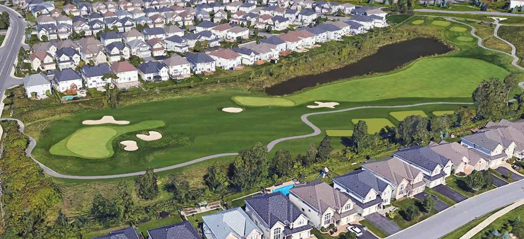
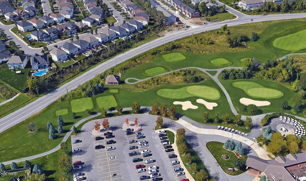
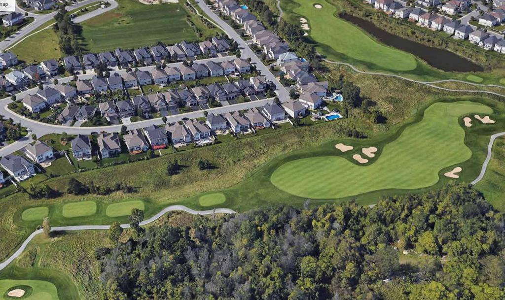
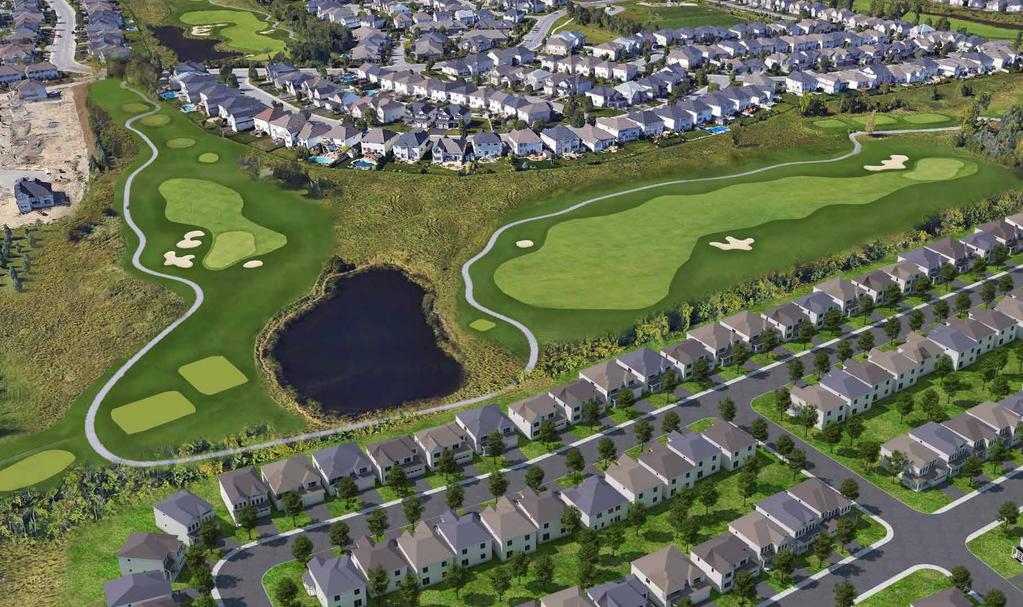
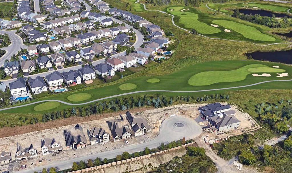
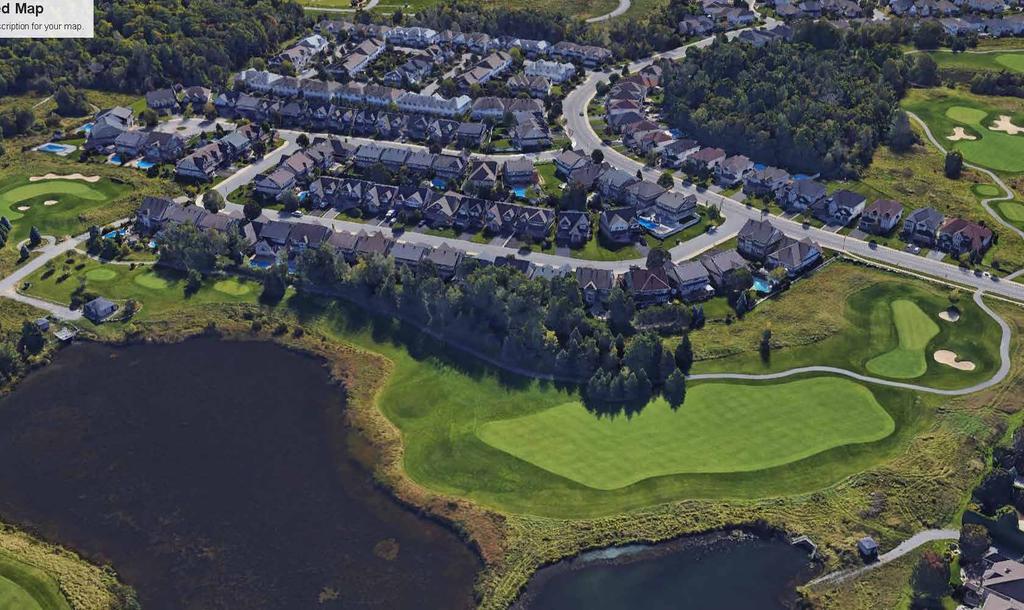
5 2.0 SITE CONTEXT AND SURROUNDING AREA Subject Lands The subject lands are located in Barrhaven South, at the edge of the urban boundary. The lands are generally bound by existing Longfields Drive to the east, vacant rural lands to the south, a portion of the existing golf course to the west, and a forthcoming Uniform subdivision at 271 Longfields Drive to the north. Figure 1 shows the subject lands in the city context. Figure 1: Subject Lands in City Context The subject lands are 9. hectares in area, comprising a portion of the 7-hectare Stonebridge Golf and Country Club. The balance of the Golf and Country Club located outside of the subject lands will continue to function as a golf course, while providing a buffer of approximately 10 metres between the proposed development and existing subdivisions to the west. The proposed subdivision will ultimately result in the reconfiguration of existing hole #7 in the golf course. Figure 2 illustrates the subject lands in a local context.

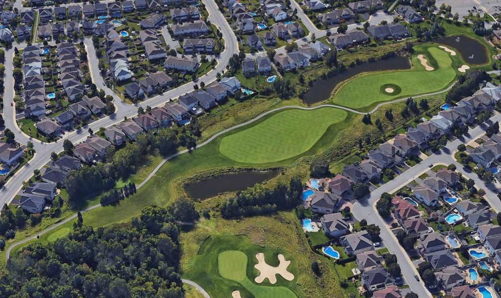
6 Figure 2: Subject Lands in Local Context 2.2 Surrounding Area North A residential subdivision developed by Uniform containing a mix of low- and medium-density residential uses as well as a park is anticipated in this location. The Minto Recreation Complex, which offers a range of amenities such as gymnasiums, a pool, ice rinks, and sports fields, is located at the southeast corner of the intersection of Cambrian Road and existing Greenbank Road, approximately 1.2 kilometres northeast of the subject lands. The Barrhaven Town Centre Mixed Use Centre is located approximately kilometres to the north of the subject lands. Approximately 5 kilometres north of the subject lands is the Fallowfield Road interchange, connecting motorists with Highway 16. East Prince of Wales Drive, a north-south arterial providing access to the downtown core, is located directly east of the subject lands. Several city-owned parks including Maple Hill, Beryl Gaffney and David Bartlett are located east of the site along the Rideau River. West The Stonebridge Golf and Country Club is located directly west of the subject lands. Existing residential development from previous phases of the Stonebridge development borders the western boundary of the Golf Club. These surrounding communities contain a mix of low- and medium-density residential uses, as well as
7 schools and parks. Further west of the site, a Community Core comprised of a mix of commercial and higherdensity residential uses is planned at the intersection of Cambrian Road and realigned Greenbank Road in accordance with the Barrhaven South CDP (2006). South The City s rural area is located south of the subject lands, with the closest village being the Village of Manotick approximately 1.2 kilometres to the southeast.

8 .0 PROPOSED DEVELOPMENT 5 Mattamy Homes proposes to subdivide the subject lands to enable the development of a residential community known as Stonebridge Phase 16. The concept plan for the community is illustrated as Figure below. Figure : Concept Plan for Stonebridge The subdivision includes a range of housing types and densities, including detached homes and townhouses. Table 1 summarizes the breakdown of each dwelling type and model. Table 1: Breakdown of Proposed Dwelling Units Unit Type Total Units Percentage of Total Detached 91 58% 1m Single 29 19% 11m Single 62 9% Townhouses 67 2% Executive Townhome 67 2% Total %
9 6.1 Parkland A park totaling 0.75 hectares is reserved for a Neighbourhood Park at the northern portion of the subject lands (Block 99). The park is located directly west of the main access point to the subdivision from Longfields Drive. The Neighbourhood Park will have limited frontage along Longfields Drive to the northeast, on Street 1 to the east, Street to the west, and on the anticipated subdivision to the north. A pedestrian connection along the northern property line of the proposed subdivision will provide park space for the residents of the adjacent Uniform subdivision. The City of Ottawa Parkland Dedication By-law ( ) requires the dedication of 1 hectare of parkland for every 00 units (for densities of 18 dwellings per net hectare or more). At 158 units, a total of 0.5 hectares of parkland are required. The proposed parkland represents a modest over-dedication of 0.29 hectares of parkland, accounting for the parkland requirements for the Uniform subdivision to the north. The Draft Plan of Subdivision is shown as Figure below: Figure : Draft Plan of Subdivision.2 Streets As established in the City of Ottawa Transportation Master Plan (201), the portion of Longfields Drive between Cambrian Road and Prince of Wales Drive is anticipated to be widened from two to four lanes. The road widening will also result in a roundabout located at the entrance to the subdivision. The road widening is
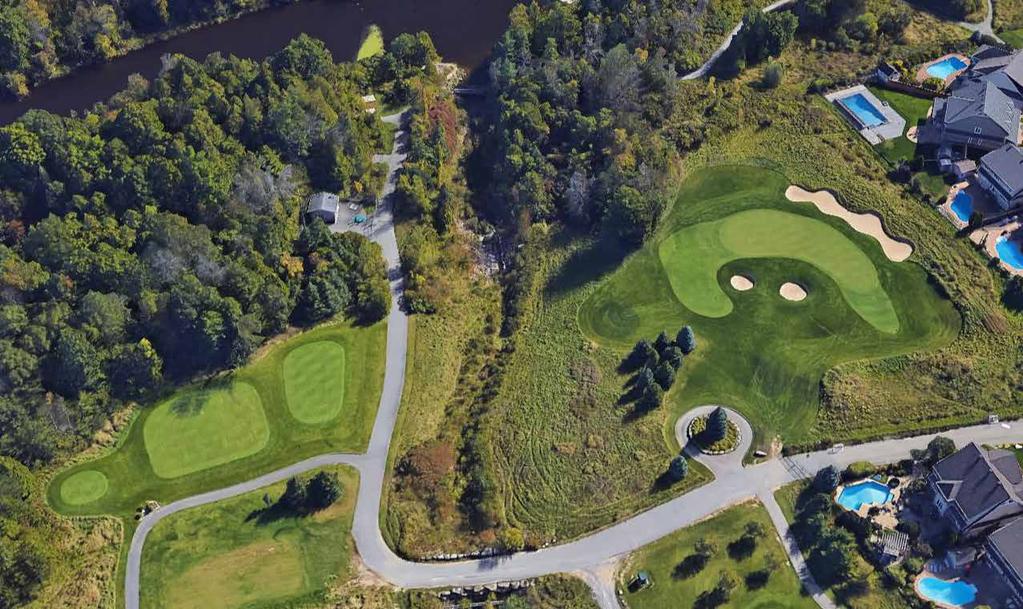
10 7 projected to occur between , which will ameliorate the increased traffic demand anticipated from surrounding development in the near future. The submitted Concept Plan and Draft Plan of Subdivision both illustrate the ultimate condition of Longfields Drive following completion of the road widening. In the interim, the Transportation Impact Assessment (TIA) prepared by Parsons proposes a minor-stop control for this intersection. The proposed street network is therefore designed to integrate with the existing and anticipated surrounding street network, while providing connectivity throughout the proposed subdivision. A southern extension of existing Kilspindie Ridge is proposed at the northeast corner of the subject lands providing access to the subdivision. The proposed roundabout at the access point will improve efficiency along Longfields Drive and calm traffic near the subdivision. The street network is proposed to terminate at a cul-de-sac adjacent to the Neighbourhood Park. Window streets along the eastern edge of the subdivision provide a buffer between the residential properties and Longfields Drive and reduce instances of rear lotting along the edge of the community. The Transportation Impact Assessment recommends that sidewalks be located on one side of the proposed streets. A road allowance is proposed to be reserved at the southern edge of the subdivision. In the event that the urban boundary is expanded, the proposed street network provides an extension to the southern edge of the subdivision. The proposed street widths are summarized in Table 2 below: Table 2: Street Hierarchy Street Type Local Streets Local Streets- Window Streets Proposed Street Width 18 m 1.5 m. Stormwater Management Facility The Adequacy of Public Servicing Report proposes two possible locations for a new stormwater management facility. While the first option proposes that the facility be located on the existing golf course property, the second option proposes that it be located on adjacent vacant rural lands. These considerations will be further analyzed throughout the process. The pond will provide a catchment for drainage in the subdivision, as well as a possible amenity feature for residents.. Potential Golf Course Plan As mentioned above, the proposed plan of subdivision will ultimately result in the reconfiguration of the existing hole #7 in the golf course (Figure 5). Detailed renderings are found in Appendix B of the rationale.

11 8 Figure 5: Concept Plan of Hole #7
12 .0 POLICY AND REGULATORY CONTEXT 9.1 Provincial Policy Statement The Provincial Policy Statement (PPS) was issued under Section of the Planning Act in April 201. It provides direction on matters of provincial interest related to land use planning and development. The Planning Act requires that decisions affecting planning matters shall be consistent with policy statements issued under the Act. Policy defines the components that sustain healthy, liveable and safe communities, including: / Promoting efficient development and land use patterns which sustain the financial well-being of the Province and municipalities over the long term; / Accommodating an appropriate range and mix of residential, employment, institutional, recreation, park and open space, and other uses to meet long-term needs; / Promoting cost-effective development patterns and standards to minimize land consumption and servicing costs; and / Ensuring that necessary infrastructure, electricity generation facilities and transmission and distribution systems, and public service facilities are or will be available to meet current and projected needs. Policy requires that settlement areas shall be the focus of growth and development, and their vitality and regeneration shall be promoted. Specifically, Policy clarifies that land use patterns within settlement areas shall be based on: / Densities and a mix of land uses which: o Efficiently use land and resources; and o Are appropriate for, and efficiently use, the infrastructure and public service facilities which are planned or available, and avoid the need for their unjustified and / or uneconomical expansion; and Policy states that new development taking place in designated growth areas should occur adjacent to the existing built-up area and shall have a compact form, mix of uses and densities that allow for the efficient use of land, infrastructure, and public service facilities. Policy 1.. states that planning authorities must: / Provide for an appropriate range and mix of housing types and densities to meet projected requirements of current and future residents, including special needs requirements; / Direct the development of new housing towards locations where appropriate levels of infrastructure and public service facilities are or will be available to support current and projected needs; / Promote densities for new housing which efficiently use land, resources, infrastructure and public service facilities, and support the use of active transportation and transit in areas where it exists or is to be developed; and / Establish development standards for residential intensification, redevelopment, and new residential development which minimize the cost of housing and facilitate compact form, while maintaining appropriate levels of public health and safety.
13 10 Policy states that healthy, active communities should be promoted by: / Planning public streets, spaces and facilities to be safe, meet the needs of pedestrians, foster social interaction and facilitate active transportation and community connectivity; and / Planning and providing for a full range and equitable distribution of publicly-accessible built and natural settings for recreation, including facilities, parklands, public spaces, open space areas, trails and linkages, and, where practical, water-based resources. Policy states that planning authorities should promote green infrastructure to complement infrastructure. Policy states that planning for stormwater management shall: / Minimize, or, where possible, prevent increases in contaminant loads; / Minimize changes in water balance and erosion; / Not increase risks to human health and safety and property damage; / Maximize the extent and function of vegetative and pervious surfaces; and / Promote stormwater management best practices, including stormwater attenuation and re-use, and low impact development. The proposed plan of subdivision is consistent with the policies of the Provincial Policy Statement (201). The development proposes a range of housing types within the settlement area boundary, as well as appropriate infrastructure and public service facilities to serve the new community. The plan also proposes two viable options for stormwater management ponds which are provided to manage stormwater..2 City of Ottawa Official Plan (200, as amended) In a pre-application consultation meeting with the City of Ottawa on December 1 th, 2017, and in accordance with previous direction, it was confirmed that the subject lands are located within the Urban Boundary and designated General Urban Area. The General Urban Area designation permits all types and densities of housing, as well as employment, retail uses, service, industrial, cultural, leisure, greenspace, entertainment and institutional uses. The designation permits the development of a full range and choice of housing types to meet the needs of all ages, incomes and life circumstances. The evaluation of development applications, studies, other plans and public works undertaken by the City in the General Urban Area will be in accordance with Section and Section.11 of the Official Plan. Section of the Official Plan contains a set of Design Objectives and Principles for development across the City. The proposed development meets the objectives as follows: / To enhance the sense of community by creating and maintaining places with their own distinct identity The subdivision continues the built form character and identity of adjacent communities, including housing forms, densities, land uses, and patterns of open space.

14 11 / To define quality public and private spaces through development The subdivision is designed to feature a connected network of streets and a park that provide areas for gathering, socializing, recreation, and other activities. / To create places that are safe, accessible, and are easy to get to, and move through The proposed street network is designed to integrate with the surrounding street pattern, creating a logical configuration that facilitates movement and connectivity. The proposed roundabout is also designed to create a safer environment for motorists, cyclists and pedestrians alike. Front and side yards abut or face the proposed park block to ensure passive surveillance of the public space. / To ensure that new development respects the character of existing areas The proposed subdivision continues the built form and land use characters of surrounding communities. The road network integrates with the surrounding network, improving connectivity for all modes of transportation. / To consider adaptability and diversity by creating places that can adapt and evolve easily over time and that are characterized by variety and choice The subdivision contains a variety of housing types that permit a range of demographics and incomes to live in the community. / To understand and respect natural processes and features in development design The proposed stormwater management system, including the stormwater management pond, will respond to the natural topography of the subject lands and the quality of the soils. / To maximize energy efficiency and promote sustainable design to reduce the resource consumption, energy use, and carbon footprint of the built environment The proposed zoning permits alternative development standards that reduce land consumption and permit increased gross densities. Policy 2 of Section.11 contains evaluation criteria for urban design and compatibility. The proposed development meets the following applicable criteria: / Traffic: A Transportation Impact Assessment was prepared for the development application, confirming that the transportation system will be functional, including traffic from private motorists. / Vehicular Access: The subdivision will feature vehicular access to all properties, with a functional street network of local streets. Vehicular access to the subdivision is gained from Longfields Drive, an existing arterial road. / Noise and Air Quality: The proposed land uses are not anticipated to result in noise or air quality impacts on sensitive uses in the subdivision. / Sunlight: As the proposed development contains low-profile buildings, shadowing impacts within the new community are not anticipated. / Supporting Neighbourhood Services: The proposed subdivision features a park and is in close proximity to other neighbourhood parks, schools, and a recreation complex.
15 12 Policy.7.8 of the Official Plan requires an Environmental Impact Statement for development within 0 metres of a natural heritage system feature in the urban area. An Environmental Impact Statement has been submitted with this application, which confirms that negative impacts to the listed Species at Risk (SAR) or other natural heritage features are not anticipated as a result of the proposed plan of subdivision. The EIS highlights that mitigations for Barn Swallows may be required. This will be confirmed through additional site bird surveys. The proposed Plan of Subdivision and Zoning By-law Amendment applications are consistent with the policies of the Official Plan.. Official Plan Amendment (OPA) 150 In 201, the City of Ottawa reviewed its Official Plan, which resulted in numerous changes to policy references and land use designations. Ottawa Council adopted Official Plan Amendment (OPA) 150 to implement the changes in December 201 and it was subsequently approved by the Ministry of Municipal Affairs and Housing (MMAH) and then appealed by several parties. A pre-hearing held in early 2018 resolved several outstanding appeals, bringing into full force and effect some policies of OPA 150. Other policies remain under appeal at the time of application submission. OPA 150 proposes changes to some policies in the General Urban Area designation, including introducing a maximum building height of four storeys or less, except in particular cases. As only low-rise buildings are proposed in the subdivision, this change does not impact the proposed development. New design criteria are also incorporated into the revised policies of Section.11, many of which relate to highrise buildings. None of the changes have a significant impact on the proposed development. The proposed development conforms to the policy revisions proposed through OPA Urban Design Guidelines for Greenfield Neighbourhoods The City of Ottawa Council approved a set of Urban Design Guidelines for Greenfield Neighbourhoods in September The guidelines outline the City s expectations during the development review process for greenfield neighbourhoods. The proposal meets several of the guidelines, including: / Considers soils, landforms, natural and cultural features, habitats, watercourses and climate in the design of the community; / Proposes a park at the northern portion of the development; / Proposes the connection of new streets to existing streets in adjacent developments and plans for future connections to land that has yet to be developed; / Lays out local street patterns so that development blocks are easily walkable; / Locates the Neighbourhood Park along a local street, and proposes a shape appropriate for programming; / Proposed window streets allow for a buffer between residential properties and Longfields Drive; and / Proposed zoning allows residential buildings to be located close to the property line.

16 1.5 Comprehensive Zoning By-law As illustrated on Figure 10, the subject lands are currently zoned Parks and Open Space, Subzone A (O1A) in the Comprehensive Zoning By-law ( ). The Parks and Open Space Zone is intended to: / Permit parks, open space and related and compatible uses to locate in areas designated as General Urban Area, General Rural Area, Major Open Space, Mixed-Use Centre, Village, Greenbelt Rural and Central Area as well as in Major Recreational Pathway areas and along River Corridors as identified in the Official Plan, and / Ensure that the range of permitted uses and applicable regulations is in keeping with the low scale, low intensity open space nature of these lands. The O1A Subzone is intended to permit a golf course use in addition to other permitted uses. Figure 6: Zoning Map As the subject lands are entirely zoned O1A, the existing zoning is inappropriate for the proposed subdivision. As such, the Zoning By-law Amendment application seeks to rezone the portion of the subdivision which will contain the proposed Neighbourhood Park to Parks and Open Space (O1) and rezone the proposed residential portion of the subject lands to Residential Third Density Z Subzone, (RZ).

17 1 Figure 11 identifies the location of the proposed zones. Full details for the O1 and RZ zone are summarized in Appendix A to the Planning Rationale. Figure 7: Proposed Zoning
18 5.0 SUPPORTING STUDIES Assessment of Phase 1 Environmental Site Assessment Paterson Group conducted a Phase 1 Environmental Site Assessment which provided a research of the past and current uses of the site, as well as an identification of any environmental concerns which may impact the subject property. Based on the findings, the report concluded that selenium was identified above the MOECC standard in two of the four samples. Although its source is unknown, it is possible that the concentrations of selenium are naturally occurring. Additional soil testing is recommended in order to further evaluate the presence of selenium. Beyond this finding, the report cites no further concerns regarding the appropriateness of the soil for the proposed development. 5.2 Adequacy of Public Servicing Report IBI Group prepared an Adequacy of Public Servicing report which provided an assessment of availability of servicing throughout the subject site. More specifically, the study analyzed water distribution, wastewater disposal, stormwater management, grading and sediment and erosion control. Based on the findings, the report concludes that water, wastewater and stormwater systems required to accommodate the proposed plan of subdivision are available. 5. Assessment of Transportation Impact Assessment A Transportation Impact Assessment was prepared by Parsons. Based on the findings the report concludes that one access point from Longfields Drive is sufficient for the proposed plan of subdivision. The report also highlights that the proposed plan of subdivision will not contribute to capacity issues. 5. Roadway Traffic Noise Feasibility Assessment A roadway traffic noise feasibility assessment was prepared by Gradient Wind Engineering. Based on the findings, the report concludes that the highest roadway traffic noise levels will occur along Longfields Drive. Outdoor living areas with exposure to the noise sources within 100 metres of Longfields Drive may therefore require noise control measures. A detailed roadway traffic noise study will be required at the time of site plan approval to further determine control measures for the purposes of development. 5.5 Environmental Impact Assessment An Environmental Impact Statement (EIS) was prepared by Kilgour & Associates. Based on the findings, the report concludes that negative impacts to the listed Species at Risk (SAR) or other natural heritage features are not anticipated as a result of the proposed plan of subdivision. The EIS highlights that mitigations for Barn Swallows may be required. This will be confirmed through additional site bird surveys.
 of the Planning Act.")
19 6.0 CONCLUSIONS 16 The proposed Stonebridge subdivision meets the policies of the Official Plan. Additionally, the subdivision meets several Urban Design Guidelines for Greenfield Neighbourhoods. The proposed development is also consistent with the Provincial Policy Statement and the criteria for subdivisions in Section 51(2) of the Planning Act. In our professional opinion, the draft Plan of Subdivision and the Zoning By-law Amendment applications are appropriate for the lands and are in the public interest. Jaime Posen, MCIP RPP Senior Planner Ghada Zaki Planner
20 APPENDIX A: PROPOSED ZONING DETAILS Residential Third Density Subzone Z / Detached dwelling: o Minimum Lot Width: 9 m o Maximum Building Height: 10 m o Minimum Lot Area: 20 m o Minimum Front Yard Setback: m o Minimum Corner Side Yard Setback: m o Minimum Rear Yard Setback: 6 m o Minimum Interior Side Yard Setback: 1.8 metres, with one minimum yard no less than 0.6 m o Minimum setback between the vehicular entrance to a private garage or carport and an existing or planned sidewalk: 6.2 m o No portion of a private garage or carport shall be located more than 2.5 m closer to a street lot line than the closer of: a building front wall or side wall, or a covered porch or veranda that is at least 2.5 m wide. / Townhouse dwelling: o Minimum Lot Width: 6 m o Maximum Building Height: 10 m o Minimum Lot Area: 150 m o Minimum Front Yard Setback: m o Minimum Corner Side Yard Setback: m o Minimum Rear Yard Setback: 6 m o Minimum Interior Side Yard Setback: 1.2m o Minimum setback between the vehicular entrance to a private garage or carport and an existing or planned sidewalk: 6.2 m o No portion of a private garage or carport shall be located more than 2.5 m closer to a street lot line than the closer of: a building front wall or side wall, or a covered porch or veranda that is at least 2.5 m wide. Parks and Open Space Zone o Minimum Lot Width: No minimum o Minimum Lot Area: No minimum o Minimum Front Yard Setback: 7.5 m o Minimum Corner Side Yard Setback: 7.5 m o Minimum Rear Yard Setback: 7.5 m o Minimum Interior Side Yard Setback: 7.5 m o Maximum Building Height: 11 m o Maximum Lot Coverage (%): 20
21 APPENDIX B: GOLF COURSE DESIGN

22 NTS E V I R KS D N I L F GOL D A O R N A I R B M CA LON ELD SD RIV E NIE BIR KIL GFI VE DRI Park PRINCE O F WALES D ROA DRIVE ANK ENB GRE PHASE 16 Stonebridge Golf Club Golf Course Scorecard Front Nine Tees Black Blue Gold White Red Par Stonebridge Golf Club Golf Course Scorecard # # # # # # # # Out # # # # # # # # # In Back Nine Front Nine Tees Black Blue Gold White Red Par # # # # # # # # # # Out # # # # # # # # # In Tees Black Blue Gold White Red Par Total Back Nine Tees Black Blue Gold White Red Par Total STONEBRIDGE GOLF CONCEPT PLAN 01


23 FRONT MODIFIED HOLES EXISTING HOLES AERIAL VIEWS 02


24 BACK MODIFIED HOLES EXISTING HOLES AERIAL VIEWS 0


25 PHASE 16 CONCEPT PLAN LEGEND 1 LON Park GFI Single Detached ELD Townhomes SD RIV E PRINCE OF WAL ES DRIV E 1 1:100 PARK CONCEPT PLAN LEGEND 1 Open Lawn 2 Senior Playground Junior Playground Berm w. Buffer Planting 5 Trail to Uniform Property :50 PHASE 16 CONCEPT PLAN 0
2983 NAVAN ROAD ZONING BY-LAW AMENDMENT
 2983 NAVAN ROAD ZONING BY-LAW AMENDMENT June 29, 2018 Planning Rationale Zoning By-law Amendment Prepared for: Taggart Realty Management 225 Metcalfe, Suite 708 Ottawa, ON, K2P 1P9 taggart.ca Prepared
10 COPE DRIVE. May 08, 2018 Planning Rationale and Design Brief. Site Plan Control
 10 COPE DRIVE May 08, 2018 Planning Rationale and Design Brief Site Plan Control Prepared for: Taggart Realty Management 225 Metcalfe Street, Suite 708 Ottawa, ON K2P 1P9 taggart.ca Prepared by: Fotenn
KANATA CENTRUM 255 KANATA AVENUE OFFICIAL PLAN AMENDMENT ZONING BY-LAW AMENDMENT
 KANATA CENTRUM 255 KANATA AVENUE OFFICIAL PLAN AMENDMENT ZONING BY-LAW AMENDMENT JUNE 2015 PREPARED BY: FOTENN Consultants Inc. 223 Mcleod Street Ottawa, ON K2P OZ8 (613) 730-5709 PREPARED FOR: Kanata
Design Brief and Planning Rationale. for Site Plan Control Application. Harmony Subdivision, Stage 1, Block 104
 Design Brief and Planning Rationale for Site Plan Control Application Harmony Subdivision, Stage 1, Block 104 4025 Strandherd Drive, Minto Communities Inc. Prepared By: NOVATECH Suite 200, 240 Michael
178 Carruthers Properties Inc.
 178 Carruthers Properties Inc. Planning Rationale for 178 Carruthers Avenue Site Plan Control Application June 2014 Table of Contents 1.0 Introduction 2.0 Overview of Subject Property 3.0 Current Zoning
2136 & 2148 Trafalgar Road Town of Oakville Region of Halton
 PLANNING JUSTIFICATION REPORT 2136 & 2148 Trafalgar Road Town of Oakville Region of Halton Zoning By-Law Amendment Application 2500674 Ontario Inc. November 2016 Table of Contents Page 1.0 Location/Summary
Planning Rationale Fernbank Road, Ottawa. Major Zoning By-law Amendment and Site Plan Control Application Ontario Inc.
 Planning Rationale Major Zoning By-law Amendment and Site Plan Control Application 5264 Fernbank Road, Ottawa 1872089 Ontario Inc. March 2014 Planning Rationale Major Zoning By-law Amendment and Site Plan
141 GEORGE STREET PLANNING RATIONALE
 141 GEORGE STREET PLANNING RATIONALE MINOR ZONING BY-LAW AMENDMENT NOVEMBER 2, 2016 PLANNING RATIONALE 223 McLeod Street Ottawa, ON K2P 0Z8 613.730.5709 fotenn.com INTRODUCTION FOTENN Consultants is acting
PLANNING RATIONALE FOR ZONING BY-LAW AMENDMENT MINTO COMMUNITIES INC. ARCADIA RESIDENTIAL STAGES 3 & 4 ARCADIA COMMERCIAL STAGE 2 CITY OF OTTAWA
 PLANNING RATIONALE FOR ZONING BY-LAW AMENDMENT MINTO COMMUNITIES INC. ARCADIA RESIDENTIAL STAGES 3 & 4 ARCADIA COMMERCIAL STAGE 2 CITY OF OTTAWA Prepared for: MINTO COMMUNITIES INC. 180 Kent Street, Suite
URBAN DESIGN BRIEF. 2136&2148 Trafalgar Road. Town of Oakville
 URBAN DESIGN BRIEF 2136&2148 Trafalgar Road Town of Oakville Prepared By: METROPOLITAN CONSULTING INC For 2500674 Ontario Inc November 2016 TABLE OF CONTENTS Page No. 1.0 Introduction/Description of Subject
The Corporation of the TOWN OF MILTON
 Report to: From: Chair & Members of the Administration & Planning Standing Committee W.F. Mann, Director of Planning and Development Date: April 16, 2012 PD 022-12 (Z19/11) Subject: Technical Report Proposed
Greystone Village Main Street. Terraces at Greystone. City of Ottawa. Planning Rationale
 Greystone Village - 175 Main Street Terraces at Greystone City of Ottawa Planning Rationale Prepared By: NOVATECH Suite 200, 240 Michael Cowpland Drive Ottawa, Ontario K2M 1P6 August / 7 / 2015 Novatech
ELMVALE ACRES SHOPPING CENTRE MASTER PLAN
 ELMVALE ACRES SHOPPING CENTRE MASTER PLAN Contents 1.0 INTRODUCTION... 2 2.0 LOCATION... 2 3.0 EXISTING CONTEXT... 2 4.0 VISION & GUIDING PRINCIPLES... 2 5.0 LAND USE AND BUILT FORM... 4 5.1 St. Laurent
CONTENTS 8.0 LAND USE 8.1 GENERAL LAND USE 8.2 RESIDENTIAL 8.3 MIXED USE 8.4 COMMERCIAL 8.5 EMPLOYMENT LANDS
 8-2 Land Use 8.0 LAND USE CONTENTS 8.1 GENERAL LAND USE 8.1.1 Uses provided for in all Land Use Designations 8.1.2 Uses prohibited in Hazardous Lands, Hazardous Sites and Special Policy Areas 8.1.3 Uses
URBAN DESIGN BRIEF URBAN DESIGN BRIEF 721 FRANKLIN BLVD, CAMBRIDGE August 2018
 URBAN DESIGN BRIEF URBAN DESIGN BRIEF 721 FRANKLIN BLVD, CAMBRIDGE August 2018 DESIGN BRIEF CONTENTS PART A 1.0 INTRODUCTION 2.0 DESCRIPTION & ANALYSIS OF SITE CONTEXT 3.0 DESIGN CONSTRAINTS AND OPPORTUNITIES
770 BRONSON AVENUE. Zoning By-law Amendment and Site Plan Control
 770 BRONSON AVENUE Zoning By-law Amendment and Site Plan Control Revised Planning Rationale + Design Brief August 2016 REVISED PLANNING RATIONALE 223 McLeod Street Ottawa, ON K2P 0Z8 613.730.5709 fotenn.com
1120 Haist Street - Pelham Arena Community Co-Design Recommendation Report Haist Street - Pelham Arena Community Co-Design Recommendation Report
 1120 Haist Street - Pelham Arena Community Co-Design Executive Summary: In May, 2017 the Town retained the services of The Planning Partnership to undertake a community design charrette process to determine
Welcome. Walk Around. Talk to Us. Write Down Your Comments
 Welcome This is an information meeting introducing the applications for proposed redevelopment of the Yorkdale Shopping Centre site at 3401 Dufferin Street and 1 Yorkdale Road over the next 20+ years,
Commercial Development Proposal Tenth Line Road. Planning Rationale Report. Minto Developments Inc.
 Commercial Development Proposal 2168 Tenth Line Road Report September 2015 Prepared for Minto Developments Inc. Paquette Planning Associates Ltd. 56 Hutchison Avenue Ottawa, Ontario K1Y 4A3 PH: 613-722-7217
Additional Studies: Site Context
 February 16, 2011 Mr. Simon Deiaco Planner II Planning and Growth Management Department City of Ottawa 110 Laurier Avenue West Ottawa, Ontario K1P 1J1 RE: Dymon Management Ltd. Zoning By-law Amendment
PORT WHITBY COMMUNITY
 PORT WHITBY COMMUNITY SECONDARY PLAN UPDATE COMMUNITY IMPROVEMENT PLAN URBAN DESIGN GUIDELINES September 2015 DRAFT PROPOSED AMENDMENT NUMBER # to the Whitby Official Plan PURPOSE: The intent of this Amendment
280 Manse Road - Official Plan Amendment, Zoning Amendment, Draft Plan of Subdivision Applications - Preliminary Report
 STAFF REPORT ACTION REQUIRED 280 Manse Road - Official Plan Amendment, Zoning Amendment, Draft Plan of Subdivision Applications - Preliminary Report Date: March 11, 2014 To: From: Wards: Reference Number:
URBANDALE CONSTRUCTION PHASE 4B 4450 LIMEBANK ROAD PLANNING RATIONALE FOR SITE PLAN CONTROL. May Prepared for:
 URBANDALE CONSTRUCTION PHASE 4B 4450 LIMEBANK ROAD PLANNING RATIONALE FOR SITE PLAN CONTROL Prepared for: URBANDALE CONSTUCTION 2193 Arch Street Ottawa, Ontario K1G 2H5 Prepared by: J.L. RICHARDS & ASSOCIATES
Bill Leathem Drive. Planning Rationale. Official Plan Amendment / Zoning By-law Amendment / Site Plan Control. May 2, 2016
 102 Bill Leathem Drive Planning Rationale Official Plan Amendment / Zoning By-law Amendment / Site Plan Control May 2, 2016 Prepared For: The Salvation Army Barrhaven Church Prepared By: FOTENN Consultants
Bressa Developments Limited. Planning Justification Report. Revised Draft Plan of Subdivision and Zoning By-Law Amendment
 Bressa Developments Limited Revised Draft Plan of Subdivision and Zoning By-Law Amendment Planning Justification Report Part of Lots 7 & 8 Concession 1, North of Dundas Street Town of Oakville September,
Figure 1- Site Plan Concept
 Figure 1- Site Plan Concept Parking will be provided underground on three levels at rate of 1.0 space/ unit; this rate includes all visitors parking. MMM Group has prepared a parking assessment (April,
KANATA WEST BUSINESS PARK. Subdivision, Official Plan Amendment & Zoning By-law Amendment. Planning Rationale
 KANATA WEST BUSINESS PARK Subdivision, Official Plan Amendment & Zoning By-law Amendment Planning Rationale February 2014 PREPARED BY: FOTENN Consultants Inc. 223 McLeod Street Ottawa, ON K2P 0Z8 613-730-5709
776 and 784 St. Laurent Boulevard City of Ottawa
 Engineering Land / Site Development Municipal Infrastructure Environmental / Water Resources Traffic / Transportation Structural Recreational 776 and 784 St. Laurent Boulevard City of Ottawa Planning Rationale
Planning Rationale: Draft Plan of Subdivision and Rezoning
 Prepared for: GLENVIEW HOMES (CEDARVIEW) LTD. 190 O Connor Street, 11 th Floor Ottawa, ON K2P 2R3 Prepared by: J.L. RICHARDS & ASSOCIATES LIMITED 864 Lady Ellen Place Ottawa, Ontario K1Z 5M2 JLR 27190
PLANNING RATIONALE FOR THE PROPOSED RIVERSIDE SOUTH ELEMENTARY SCHOOL 715 BRIAN GOOD AVENUE, OTTAWA, ON
 PLANNING RATIONALE FOR THE PROPOSED RIVERSIDE SOUTH ELEMENTARY SCHOOL 715 BRIAN GOOD AVENUE, OTTAWA, ON Conseil des écoles publiques de l'est de l'ontario (CEPEO) French Public School Board TABLE OF CONTENTS
6 Growth Management Challenges and Opportunities
 6 Growth Management Challenges and Opportunities The Town has established a goal of attaining a 50% participation rate with respect to employment opportunities versus residential population. The Town s
Foster Creek West Clarington, Ontario PLANNING JUSTIFICATION REPORT
 Foster Creek West Clarington, Ontario PLANNING JUSTIFICATION REPORT Official Plan Amendment Zoning By-law Amendment Neighbourhood Design Plan Amendment Draft Plan of Subdivision File No. 112092 February
4780 Eglinton Avenue West - Zoning By-law Amendment and Draft Plan of Subdivision Applications - Preliminary Report
 STAFF REPORT ACTION REQUIRED 4780 Eglinton Avenue West - Zoning By-law Amendment and Draft Plan of Subdivision Applications - Preliminary Report Date: May 29, 2014 To: From: Wards: Reference Number: Etobicoke
MAYFIELD WEST SECONDARY PLAN PHASE 2
 MAYFIELD WEST SECONDARY PLAN PHASE 2 Public Open House #3 February 25, 2010 Draft Preferred Land Use Scenario TOWN OF CALEDON PLANNING & DEVELOPMENT DEPARTMENT Open House Agenda TOWN OF CALEDON 1. Welcome
The West Vaughan Employment Area Secondary Plan Policies
 Part 2: The West Vaughan Employment Area Secondary Plan Policies 2.1 General Policies It is the policy of Council: 2.1.1. That the West Vaughan Employment Area (the WVEA), identified on Schedule 1, will
Public Storage Self-storage Facility (Warehouse)
") Public Storage Self-storage Facility (Warehouse) 3545 St. Joseph Boulevard Planning Rationale PREPARED FOR: Maple Reinders Constructors Ltd. 2660 Argentia Road Mississauga, Ontario L5N 5V4 PREPARED BY:
Public Storage Self-storage Facility (Warehouse) 3545 St. Joseph Boulevard Planning Rationale PREPARED FOR: Maple Reinders Constructors Ltd. 2660 Argentia Road Mississauga, Ontario L5N 5V4 PREPARED BY:
PLANNING JUSTIFICATION REPORT
 PLANNING JUSTIFICATION REPORT 55 DELHI STREET CITY OF GUELPH PREPARED FOR: VESTERRA PROPERTY MANAGEMENT PREPARED BY: LABRECHE PATTERSON & ASSOCIATES INC. SCOTT PATTERSON, BA, CPT, MCIP, RPP PRINCIPAL,
Planning Assessment Report. Southeast Corner of John Street West & Victoria Street, Niagara-on-the-Lake April, Planning & Design Inc.
 Planning Assessment Report Southeast Corner of John Street West & Victoria Street, Niagara-on-the-Lake April, 2016 Planning & Design Inc. TABLE OF CONTENTS 1! Introduction... 1! 1.1! Purpose... 1! 1.2!
Re: 1110 Fisher Avenue Proposed Residential Development Revised Proposal File D PLANNING RATIONALE ADDENDUM
 October 23, 2014 Prestige Design & Construction 50 Camelot Drive Ottawa, ON K2G 5X8 Attention: Mr. Enzo DiChiara Dear Mr. DiChiara Re: 1110 Fisher Avenue Proposed Residential Development Revised Proposal
PLANNING AND URBAN DESIGN RATIONALE REPORT. Hunters Pointe Golf Course Redevelopment 289 Daimler Parkway Prepared For: Ontario Ltd.
 PLANNING AND URBAN DESIGN RATIONALE REPORT Hunters Pointe Golf Course Redevelopment 289 Daimler Parkway Prepared For: 2599587 Ontario Ltd. February 2018 Redevelopment of Hunters Pointe Golf Course, Welland
MINTO COMMUNITIES INC. HARMONY STAGE II 4025 STRANDHERD DRIVE CITY OF OTTAWA
 MINTO COMMUNITIES INC. HARMONY STAGE II 4025 STRANDHERD DRIVE CITY OF OTTAWA PLANNING RATIONALE AND INTEGRATED ENVIRONMENTAL REVIEW STATEMENT IN SUPPORT OF A DRAFT PLAN OF SUBDIVISION, OFFICIAL PLAN AMENDMENT
Planning Rationale in Support of an Application for Zoning By-law Amendment
 Planning Rationale in Support of an Application for Zoning By-law Amendment 4845 Bank Street City of Ottawa Prepared by: Holzman Consultants Inc. Land Development Consultants March 16, 2015 TABLE OF CONTENTS
MANOTICK MAIN REGIONAL INC. 5721, 5731 AND 5741 MANOTICK MAIN STREET OTTAWA, ON
 MANOTICK MAIN REGIONAL INC. 5721, 5731 AND 5741 MANOTICK MAIN STREET OTTAWA, ON PLANNING RATIONALE AND INTEGRATED REVIEW STATEMENT IN SUPPORT OF A DRAFT PLAN OF SUBDIVISION AND ZONING BY-LAW AMENDMENT
MEADOWGLEN DR. ORLEANS. Zoning By-Law Amendment Application November 2012
 5911 MEADOWGLEN DR. ORLEANS Zoning By-Law Amendment Application November 2012 Prepared by: 223 McLeod Street Ottawa, ON K2P 0Z8 T: 613.730.5709 ext.238 F: 613.730.1136 Prepared for: 371A Richmond Road,
8 Oak Street - Official Plan and Zoning By-law Amendment Application - Preliminary Report
 STAFF REPORT ACTION REQUIRED 8 Oak Street - Official Plan and Zoning By-law Amendment Application - Preliminary Report Date: March 17, 2014 To: From: Wards: Reference Number: Planning and Growth Management
Re: Hazeldean Road - Minto Potters Key Subdivision Responses to Resident Concerns
 November 28, 2015 D07-16-14-0013 Councillor Shad Qadri 110 Laurier avenue west Ottawa, Ontario K1P 1J1 Dear Councillor Qadri, Re: 6111 6141 Hazeldean Road - Minto Potters Key Subdivision Responses to Resident
9 CITY OF VAUGHAN OFFICIAL PLAN AMENDMENT NO BOCA EAST INVESTMENTS LIMITED
 9 CITY OF VAUGHAN OFFICIAL PLAN AMENDMENT NO. 631 - BOCA EAST INVESTMENTS LIMITED The Planning and Economic Development Committee recommends the adoption of the recommendations contained in the following
20 & 30 Frank Nighbor Place
 Engineering Land / Site Development Municipal Infrastructure Environmental / Water Resources Traffic / Transportation Structural Recreational Planning Land / Site Development Planning Application Management
MILTON HEIGHTS COMMUNITY January 2006 Revised February 2015 Revised November 2015
 REVISED DRAFT MILTON HEIGHTS COMMUNITY January 2006 Revised February 2015 Revised November 2015 Urban Design Guidelines Milton Heights Landowners Group This page has been intentionally left blank. Contents
PLANNING RATIONALE. for. Site Plan Application
 PLANNING RATIONALE for Site Plan Application 2781, 2791, and 2797 Baseline Road And 2704, 2706, and 2734 Draper Avenue Prepared by: Lloyd Phillips & Associates Ltd. File: 0811 Planning Rationale Page 1
PLANNING RATIONALE. 223 McLeod Street Ottawa, ON K2P 0Z fotenn.com. 17 December 2015
 PLANNING RATIONALE 223 McLeod Street Ottawa, ON K2P 0Z8 613.730.5709 fotenn.com 17 December 2015 INTRODUCTION FOTENN Consultants Inc. has been retained to prepare a Major Zoning By-law Amendment Application
Prepared for: Ontario Limited
 Application for Zoning By-law Amendment and Plan of Subdivision 1353 Scharfgate Drive Planning Rationale Report Prepared for: 1384341 Ontario Limited November 28, 2014 Revised August 18, 2015 Planning
Planning Rationale in Support of an Application for Zoning By-Law Amendment. 4495, 4499, 4509 & 4515 Innes Road City of Ottawa
 Planning Rationale in Support of an Application for Zoning By-Law Amendment 4495, 4499, 4509 & 4515 Innes Road City of Ottawa Prepared by: Holzman Consultants Inc. Land Development Consultants March 26,
STAFF REPORT. December 20, North York Community Council. Director, Community Planning, North York District
 STAFF REPORT December 20, 2005 To: From: Subject: North York Community Council Director, Community Planning, North York District Preliminary Report Application to Amend the Official Plan and Zoning By-law
5.0 VILLAGE AREAS. February 2008 Municipality of West Elgin ~ Official Plan 5-1
 5.0 VILLAGE AREAS This section of the Official Plan deals with the villages of Rodney and West Lorne being the two largest and only fully serviced settlement areas in West Elgin and the most logical and
FORMER CANADIAN FORCES BASE (CFB) ROCKCLIFFE SECONDARY PLAN. Official Plan Amendment XX to the Official Plan for the City of Ottawa
 ROCKCLIFFE SECONDARY PLAN. Official Plan Amendment XX to the Official Plan for the City of Ottawa") FORMER CANADIAN FORCES BASE (CFB) ROCKCLIFFE SECONDARY PLAN Official Plan Amendment XX to the Official Plan for the City of Ottawa 1 INDEX THE STATEMENT OF COMPONENTS PART A THE PREAMBLE PAGE Purpose...
FORMER CANADIAN FORCES BASE (CFB) ROCKCLIFFE SECONDARY PLAN Official Plan Amendment XX to the Official Plan for the City of Ottawa 1 INDEX THE STATEMENT OF COMPONENTS PART A THE PREAMBLE PAGE Purpose...
URBAN DESIGN BRIEF 181 Burloak Drive, Oakville
 URBAN DESIGN BRIEF 181 Burloak Drive, Oakville February 2017 Our File: 1730B 230-7050 WESTON ROAD / WOODBRIDGE / ONTARIO / L4L 8G7 / T: 905 761 5588/ F: 905 761 5589/WWW.MHBCPLAN.COM TABLE OF CONTENTS
Lacolle Way. Planning Rationale. Zoning By-law Amendment Site Plan Control. November 17, 2016
 571 Lacolle Way Planning Rationale Zoning By-law Amendment Site Plan Control November 17, 2016 Prepared By: FOTENN Consultants Inc. 223 McLeod Street Ottawa, ON K2P 0Z8 www.fotenn.com 613.730.5709 TABLE
Richmond Secondary Plan
 1.0 Introduction Richmond was founded in 1818 and is the oldest community in the former Township of Goulbourn. Historically, growth in Richmond has been modest with a population that now approaches 4,500
ONTARIO MUNICIPAL BOARD
 PL 120483 ONTARIO MUNICIPAL BOARD Applicant/Appellant: 2124123 Ontario Limited Subject: OPA, Rezoning and Draft Plan of Subdivision Municipal Address: 3940 Highway 7 East Municipality: City of Markham
Planning Rationale Village of Richmond, West
 Planning Rationale Village of Richmond, West 6335 & 6431 Perth Street Planning Rationale - Village of Richmond, West Supporting the Plan of Subdivison & Zoning Amendment Application Prepared For: Richmond
Edward R. Sajecki Commissioner of Planning and Building. Land Use Review- Former Parkway Belt West Lands- Fieldgate Drive and Audubon Boulevard
 Corporate Report Clerk s Files Originator s Files CD.04.FOR DATE: November 15, 2011 TO: FROM: SUBJECT: Chair and Members of Planning and Development Committee Meeting Date: December 5, 2011 Edward R. Sajecki
PLANNING JUSTIFICATION REPORT
 PLANNING JUSTIFICATION REPORT 556, 560 and 576 Conservation Drive 2115881 Ontario Limited City of Waterloo, Regional Municipality of Waterloo Zoning By-law Amendment Draft Plan of Subdivision July 2016
150 Eighth Street Zoning By-law Amendment Application Preliminary Report
 REPORT FOR ACTION 150 Eighth Street Zoning By-law Amendment Application Preliminary Report Date: March 27, 2019 To: Etobicoke York Community Council From: Director, Community Planning, Etobicoke York District
Van Gaal Lands Terry Fox Drive & 5331 Fernbank Road. Planning Rationale and Integrated Environmental Review Statement. Engineering.
 Engineering Land / Site Development Municipal Infrastructure Environmental / Water Resources Traffic / Transportation Structural Recreational Planning Land / Site Development Planning Application Management
Land Use Amendment in Southwood (Ward 11) at and Elbow Drive SW, LOC
 at and Elbow Drive SW, LOC") 2018 November 15 Page 1 of 10 EXECUTIVE SUMMARY This land use amendment application was submitted by Rick Balbi Architect on 2017 August 31 on behalf of Sable Developments Ltd, and with authorization from
2018 November 15 Page 1 of 10 EXECUTIVE SUMMARY This land use amendment application was submitted by Rick Balbi Architect on 2017 August 31 on behalf of Sable Developments Ltd, and with authorization from
Urban Design Brief. Watson Parkway North & Watson Road North Guelph, Ontario. Prepared by Coletara Development
 Urban Design Brief Watson Parkway North & Watson Road North Guelph, Ontario Prepared by Coletara Development December, 2013 Urban Design Brief, Coletara Development 1 Introduction This Urban Design Brief
Westwind Developments Ltd. PIONEER LANDS AREA STRUCTURE PLAN - PROPOSED AMENDMENT
 FEBRUARY 2013 TABLE OF CONTENTS 1.0 BACKGROUND... 1 1.1 Amendment... 1 2.0 LOCATION & CONTEXT... 2 2.1 Land Ownership... 2 3.0 POLICY CONTEXT... 3 3.1 Municipal Development Plan... 3 3.2 Capital Region
and Richmond Street West - Official Plan Amendment Application - Preliminary Report
 STAFF REPORT ACTION REQUIRED 822-838 and 860-862 Richmond Street West - Official Plan Amendment Application - Preliminary Report Date: August 14, 2017 To: From: Wards: Reference Number: Toronto and East
DRAFT Northeast Quadrant of Kipling Avenue and Highway 7 DRAFT AUGUST 29, Goals Land Use. The goals of this Plan are to:
 AUGUST 29, 2017 12.15 Northeast Quadrant of Kipling Avenue and Highway 7 12.15.1 Goals 12.15.2 Land Use The goals of this Plan are to: 12.15.2.1 General Provisions: a) Ensure the development of a compact
Tāhuhu whakaruruhau ā-taone The sheltering ridge pole
 B2. Tāhuhu whakaruruhau ā-taone - Urban growth and form B2.1. Issues Tāhuhu whakaruruhau ā-taone The sheltering ridge pole Auckland s growing population increases demand for housing, employment, business,
Complete Neighbourhood Guidelines Review Tool
 Complete Neighbourhood Guidelines Review Tool Prepared By: City of Regina Planning Department October 2014 Page 1 of 14 Community Development Review Checklist for Secondary Plans and Concept Plans The
Table of Contents 1.0 Introduction
 Table of Contents 1.0 Introduction..1 2.0 Site Description and Surrounding Land Uses 1 3.0 Redevelopment Proposal..3 4.0 Provincial, Regional and Municipal Policy Context... 10 4.1 The Provincial Policy
12 AMENDMENT NO. 149, TOWN OF MARKHAM HIGHWAY 404 NORTH SECONDARY PLAN
 12 AMENDMENT NO. 149, TOWN OF MARKHAM HIGHWAY 404 NORTH SECONDARY PLAN The Planning and Economic Development Committee recommends the adoption of the recommendation contained in the following report August
Leonard s Beach Secondary Plan (Alcona North) Official Plan Amendment
 Official Plan Amendment") Leonard s Beach Secondary Plan (Alcona North) Official Plan Amendment Public Meeting Presentation August 14, 2013 Note: This document is for presentation purposes only. Please see Staff Report DSR-135-13
Leonard s Beach Secondary Plan (Alcona North) Official Plan Amendment Public Meeting Presentation August 14, 2013 Note: This document is for presentation purposes only. Please see Staff Report DSR-135-13
K. SMART ASSOCIATES LIMITED
 Planning Justification Report Zoning By-Law Amendment 185 King Street North Waterloo, Ontario April 7th, 2017 Project Reference Number 16-245 K. SMART ASSOCIATES LIMITED CONSULTING ENGINEERS AND PLANNERS
LAND USE AMENDMENT CORNERSTONE (WARD 3) 60 STREET NE AND COUNTRY HILLS BOULEVARD NE MAP 26NE BYLAW 22D2017
 60 STREET NE AND COUNTRY HILLS BOULEVARD NE MAP 26NE BYLAW 22D2017") Page 1 of 14 EXECUTIVE SUMMARY This Land Use Amendment application covers an area of 43.76 hectares ± (108.14 acres ±) located in northeast Calgary, bound by Country Hills Boulevard NE to the south and
Page 1 of 14 EXECUTIVE SUMMARY This Land Use Amendment application covers an area of 43.76 hectares ± (108.14 acres ±) located in northeast Calgary, bound by Country Hills Boulevard NE to the south and
Further input invited as Colchester Growth Strategy nears final phase
 IUE 3 / NOVEMBER 2015 Further input invited as Colchester Growth trategy nears final phase trathcona County is seeking public feedback as it enters the final phase of work on a Growth Management trategy
Official Plan Review
 Official Plan Review Summary Report - The Built Environment August 2014 Part 1: Introduction Planning for a healthy, prosperous and sustainable community is an important goal for our municipality. From
6 PORT SYDNEY SETTLEMENT AREA
 Section 6 Port Sydney Page 61 6 PORT SYDNEY SETTLEMENT AREA 6.1 Basis and Principles Village of Port Sydney Waterfront Community Existing Services 6.1.1 Port Sydney is an historic settlement that has developed
Queen Street West - Zoning Amendment Application - Preliminary Report
 STAFF REPORT ACTION REQUIRED 944-952 Queen Street West - Zoning Amendment Application - Preliminary Report Date: February 6, 2013 To: From: Wards: Reference Number: Toronto and East York Community Council
A Growing Community Rural Settlement Areas
 Town of Huntsville Official Plan Review - POLICY BACKGROUND PAPER A Growing Community Rural Settlement Areas BACKGROUND: In addition to the fully municipally-serviced Urban Settlement Area and the Hidden
4155 Yonge Street Official Plan Amendment and Rezoning Application Preliminary Report
 STAFF REPORT ACTION REQUIRED 4155 Yonge Street Official Plan Amendment and Rezoning Application Preliminary Report Date: May 5, 2011 To: From: Wards: Reference Number: North York Community Council Director,
240 and 242 Finch Avenue West Zoning By-law Amendment Application Preliminary Report
 REPORT FOR ACTION 240 and 242 Finch Avenue West Zoning By-law Amendment Application Preliminary Report Date: March 1, 2019 To: North York Community Council From: Director, Community Planning, North York
Plan Modification to Chapter B2 of the Auckland Unitary Plan(AUP) Operative in part (15 November 2016)
 Operative in part (15 November 2016)") UNITARY PLAN UPDATE REQUEST MEMORANDUM TO FROM Phill Reid Linley Wilkinson DATE 25 September 2018 SUBJECT Plan Modification to Chapter B2 of the Auckland Unitary Plan(AUP) Operative in part (15 November
UNITARY PLAN UPDATE REQUEST MEMORANDUM TO FROM Phill Reid Linley Wilkinson DATE 25 September 2018 SUBJECT Plan Modification to Chapter B2 of the Auckland Unitary Plan(AUP) Operative in part (15 November
Bloor St. W. Rezoning - Preliminary Report
 STAFF REPORT ACTION REQUIRED 1638-1644 Bloor St. W. Rezoning - Preliminary Report Date: April 1, 2008 To: From: Wards: Reference Number: Toronto and East York Community Council Acting Director, Community
Report Regarding Site Plan Control for 55 Wellspring Way (File No. SP-06-16)
") Report Regarding Site Plan Control for 55 Wellspring Way (File No. SP-06-16) Executive Summary: The purpose of this report is to provide Council with information regarding site plan control under Section
Report Regarding Site Plan Control for 55 Wellspring Way (File No. SP-06-16) Executive Summary: The purpose of this report is to provide Council with information regarding site plan control under Section
New-Cast Mixed-use Development Proposal King Street West, Newcastle, Ontario
 URBAN DESIGN BRIEF New-Cast Mixed-use Development Proposal King Street West, Newcastle, Ontario TABLE OF CONTENTS: 1.0 Executive Summary 2.0 Creating Vibrant and Sustainable Urban Places: Excerpts from
Cardinal Creek Village CONCEPT PLAN
 This Plan was prepared by: David Schaeffer Engineering Ltd. Delcan Corporation IBI Group Inc. Muncaster Environmental Planning Inc. Richard W. Harrison & Associates Tamarack (Queen Street) Corporation
5 TOWN OF MARKHAM OFFICIAL PLAN AMENDMENT NO. 144 MILLIKEN MAIN STREET SECONDARY PLAN
 5 TOWN OF MARKHAM OFFICIAL PLAN AMENDMENT NO. 144 MILLIKEN MAIN STREET SECONDARY PLAN The Planning and Economic Development Committee recommends the following: 1. The communication from Brendan O Callaghan,
6.0 Land Use Policies for Rural Settlements. 6.1 Rural Settlement Strategy
 6.0 Land Use Policies for Rural Settlements 6.1 Rural Settlement Strategy INTRODUCTION AMENDMENT NO. 131 PURPOSE Designated rural settlements comprise Rural Clusters, Villages and Serviced Villages as
30 and 44 Zorra Street - Zoning By-law Amendment Application - Preliminary Report
 STAFF REPORT ACTION REQUIRED 30 and 44 Zorra Street - Zoning By-law Amendment Application - Preliminary Report Date: March 14, 2016 To: From: Wards: Reference Number: Etobicoke York Community Council Director,
Official Plan Review: Draft Built Form Policies
 PG.30.1 REPORT FOR ACTION Official Plan Review: Draft Built Form Policies Date: May 15, 2018 To: Planning and Growth Management Committee From: Chief Planner and Executive Director, City Planning Division
Stanley Greene District Downsview (80 Carl Hall Road) Zoning By-law Amendment and Draft Plan of Subdivision Applications Request for Direction Report
 Zoning By-law Amendment and Draft Plan of Subdivision Applications Request for Direction Report") STAFF REPORT ACTION REQUIRED Stanley Greene District Downsview (80 Carl Hall Road) Zoning By-law Amendment and Draft Plan of Subdivision Applications Request for Direction Report Date: December 16, 2011
STAFF REPORT ACTION REQUIRED Stanley Greene District Downsview (80 Carl Hall Road) Zoning By-law Amendment and Draft Plan of Subdivision Applications Request for Direction Report Date: December 16, 2011
Outline Plan in Belvedere (Ward 9) at Street SE, LOC (OP)
 at Street SE, LOC (OP)") 2018 October 04 Page 1 of 12 EXECUTIVE SUMMARY This outline plan application was submitted by B&A Planning Group on 2016 July 15, on behalf of Tristar Communities Inc. for 50.14 hectares (123.89 acres)
2018 October 04 Page 1 of 12 EXECUTIVE SUMMARY This outline plan application was submitted by B&A Planning Group on 2016 July 15, on behalf of Tristar Communities Inc. for 50.14 hectares (123.89 acres)
and services The protection and conservation of environmentally significant and sensitive natural heritage features and functions.
 6. Land Use 6.0 Preamble A healthy and livable city is one in which people can enjoy a vibrant economy and a sustainable healthy environment in safe, caring and diverse neighbourhoods. In order to ensure
PLANNING RATIONALE. Shadow Ridge Estates Subdivision, Phase Two. In Support of a Proposed Zoning By-Law Amendment. Report Number: R
 PLANNING RATIONALE Shadow Ridge Estates Subdivision, Phase Two In Support of a Proposed Zoning By-Law Amendment Report Number: R-2011-222 Prepared for: Donwel Land Inc. Prepared by: Novatech Engineering
URBAN DESIGN BRIEF. Saginaw Subdivision 124 SAGINAW PARKWAY, CAMBRIDGE OCTOBER 2015 OUR FILE 1422A
 URBAN DESIGN BRIEF Saginaw Subdivision 124 SAGINAW PARKWAY, CAMBRIDGE OCTOBER 2015 OUR FILE 1422A Contents 1.0 INTRODUCTION AND SITE DESCRIPTION... 1 2.0 MUNICIPAL DESIGN DIRECTION... 7 3.0 MASTER CONCEPT
Planning Assessment Report Victoria Street, Niagara-on-the-Lake June, Planning & Design Inc.
 Planning Assessment Report 489-495 Victoria Street, Niagara-on-the-Lake June, 2015 Planning & Design Inc. ! TABLE OF CONTENTS 1! Introduction... 1! 1.1! Purpose... 1! 1.2! Location & Surrounding Area Context...
MAYFIELD WEST SECONDARY PLAN PHASE 2
 MAYFIELD WEST SECONDARY PLAN PHASE 2 Council Information Workshop February 16, 2010 Draft Preferred Land Use Plan TOWN OF CALEDON PLANNING & DEVELOPMENT DEPARTMENT Workshop Agenda TOWN OF CALEDON 1. Welcome