VISION DOCUMENT LAND WEST OF CROUCH HOUSE ROAD EDENBRIDGE
|
|
|
- Cecily Patrick
- 5 years ago
- Views:
Transcription
1 VISION DOCUMENT LAND WEST OF CROUCH HOUSE ROAD EDENBRIDGE

2 LAND WEST OF CROUCH HOUSE ROAD, EDENBRIDGE I VISION DOCUMENT - SEPTEMBER 2018 WATES DEVELOPMENTS
3 CONTENTS 1.0 WHY EDENBRIDGE? LAND USE OUR VISION NEW HOMES THE SITE RETIREMENT LIVING WIDER CONTEXT MEDICAL HUB SITE CONDITIONS 8 Drainage 8 Ecology 9 Heritage 10 Access and Movement 11 Landscape and Visual Impact 13 Summary Opportunities and Constraints OPEN SPACE PROPOSED ACCESS IMPACT ON THE GREEN BELT WHY LAND WEST OF CROUCH HOUSE ROAD CONSULTATION AND NEXT STEPS CONCEPT MASTERPLAN ABOUT WATES DEVELOPMENTS 26 3


4 1.0 WHY EDENBRIDGE? Edenbridge as a location for growth features highly within the established settlement hierarchy and is an area that has the social and physical infrastructure to accommodate much needed new housing. Unlike the majority of the rest of the district, the town is not located within a protected landscape and development could be delivered in a way that would protect the historic core of the town centre. Edenbridge is the third largest urban area in the district and is well-placed to take a proportionate share of the 698 homes the district needs to provide each year up to Unlike the majority of the District (approx. 67% AONB) Edenbridge is not located in an area of any notable landscape importance. Edenbridge has a good range of shops, services, employment opportunities and transport links, including two mainline stations running into London Victoria and London Bridge and is therefore considered a sustainable location for growth. The town sits outside the district s protected Area of Outstanding Natural Beauty and is therefore a less sensitive urban location for more housing when compared to many other parts of the district. In this regard, national planning policy is clear that development should be prioritised in the least environmentally sensitive areas. 4 Sevenoaks District Edenbridge Sites LAND WEST OF CROUCH HOUSE ROAD, EDENBRIDGE I VISION DOCUMENT - SEPTEMBER 2018 WATES DEVELOPMENTS
5 2.0 OUR VISION This Vision Document has been prepared on behalf of Wates Developments in respect of the promotion of land west of Crouch House Road on the western extent of Edenbridge, Kent. It is our intention to promote the site for residential development, and for a wider Green Belt boundary review, during the course of the new Local Plan preparation. Based on the current national and local planning context, we consider the site to be the most suitable area to roll back the Green Belt and to allocate land for housing to help meet the growing need for new homes in the District. We also consider the site has a role to play in accommodating the wider overspill of housing need from London and elsewhere within the South East of England. Within this submission we outline the implications of the newly identified full objectively assessed need for market, affordable and specialist care housing and the wider District constraints that make Edenbridge best suited for sustainable expansion. We also provide an assessment of the site s characteristics and why it is a suitable for release from the Green Belt, including a concept masterplan of the type of development that could be delivered. To provide a residential-led extension, with a state-of-theart medical hub in close proximity to the densest residential element of the town, to form a development that represents a natural transition between town and countryside. OUR PROPOSAL INCLUDES Illustrative proposals include circa 250 to 300 new homes, which include a range of market homes, up to 40% affordable housing A specialist care village including a range of properties from unassisted-living bungalows, to warden-controlled homes and specialist care provision. Promotion of land for a new medical hub. In this regard, in 2016 NHS West Kent Clinical Commissioning Group, Kent Community Health NHS Foundation Trust and Edenbridge Medical Practice commenced work on a consultation to look at ways to improve medical provision within the town. A central green hub formed on community open space, retained ecology zones and an equipped area of play. 5

6 3.0 THE SITE Land West of Crouch House Road The site lies to the west of Edenbridge, adjacent the existing built up area and extends to approximately 18 hectares. The site is bound to the north east by Crouch House Road. To the north, south and east of the site is existing residential development. A dense tree line wraps around the western boundary running alongside an existing Public Footpath. There are three ponds located on site surrounded by mature trees. A series of hedgerows dissect the site into four distinct parcels. The site has a long eastern frontage with Crouch House Road and is located within walking distance of the existing residential development and services within Edenbridge. The Town Railway Station is located to the east of the site, accessible via Stangrove Road, equating to an 11 minute walk or four minute cycle. There are a number of heritage assets in the area including Crouch House (grade II); The Lodge (grade II); Skeynes Park (grade II); Outbuildings to north west of Skeynes Park (grade II); and Stable court to north of Skeynes Park (grade II). Edenbridge Land West of Crouch House Road 6 LAND WEST OF CROUCH HOUSE ROAD, EDENBRIDGE I VISION DOCUMENT - SEPTEMBER 2018 WATES DEVELOPMENTS


 along")

7 4.0 WIDER CONTEXT Edenbridge is situated within the southwest of Sevenoaks District close to the Kent and Surrey border. It sits on the upper floodplain of the River Medway and the River Eden runs through the centre of the town. The population of Edenbridge is circa 8,907 (2011 Census). There are two railway stations serving the town. The original station, Edenbridge, is located in the north of the town, adjacent to Marlpit Hill, and provides direct links to London Victoria (approximately 51 minutes) and Tonbridge. The second station, Edenbridge Town, is situated within the heart of the town and provides direct links to London Bridge (approximately 48 minutes) along with services to Uckfield. The two lines are not connected. Despite being a relatively small town, Edenbridge benefits from a number of important employment, leisure and community facilities. Edenbridge Leisure Centre provides the community with high quality and modern leisure facilities, whilst from a retail perspective, the town benefits from a number of shops and local services including a quality Waitrose supermarket for convenience shopping needs. Edenbridge and Hever Church of England Schools provide two opportunities for primary school provision. Existing Village facilities 7

8 5.0 SITE CONDITIONS A series of reports and surveys have been undertaken in order to fully understand the site s constraints and opportunities. These reports and surveys relate to topography, drainage, transport, ecology, heritage and landscape character. Mitigation measures will be incorporated as advised by consultants as the scheme continues to evolve. Drainage and Flood Risk THE SITE The Environment Agency flood risk maps show the entire site to be located within Flood 1 which is the lowest risk. This zone comprises land assessed as having a less than 1 in 1000 annual probability of river or sea flooding in any year. All types of development are appropriate within Flood Zone 1. The existing site can be divided into two surface water catchments. The far north part of the site drains to a valley on the western boundary where is continues to fall towards the Kent Brook located to the West of the site. The Kent Brook in turns drains to the River Eden further to the South. The rest of the site falls from the North to South towards the River Eden. Any surface water falling on the site would naturally infiltrate into ground with any residual flows following the natural topography draining to existing watercourses. EA Flood Map Land West of Crouch House Road falls outside of Flood Zone 2 and 3 shown to impact on other areas of the village. 8 LAND WEST OF CROUCH HOUSE ROAD, EDENBRIDGE I VISION DOCUMENT - SEPTEMBER 2018 WATES DEVELOPMENTS
9 5.0 SITE CONDITIONS Ecology The site does not fall within any designated sites. There are significant connective hedgerows and scattered patches of woodland within the wider landscape. The site is largely open grassland with tall ruderal species. The fields are separated by boundary hedgerows and scrub. There are several significant mature trees on site. The three ponds identified on site, and those accessible off-site, all indicated optimal conditions for supporting a breeding Great Crested Newt population. It is recommended that the ponds be retained and enhanced and a buffer exclusion zone around each one be put in place to provide habitat for common reptiles and amphibian species. The layered scrub and trees along the boundaries of the site, along with the small woodland to the north creates optimal habitat for dormice. There are a number of tree species associated with dormice such as oak, hazel and birch as well as bramble present on site providing a number of food sources. These are to be retained as part of the scheme. No badgers latrines or setts or snuffle holes were found on site, however distinct mammal pathways were found with holes disappearing into the scrub hedgerows. Ecology Survey Notwithstanding the need to undertake additional survey work, due the scale of the site there is scope to provide substantial mitigation areas and therefore ecology is not considered to be a constraint to development. The vast majority of ecological and arboricultural assets can be retained and enhanced through good design and careful masterplanning to ensure a sensitively designed scheme. 9


10 5.0 SITE CONDITIONS Heritage Views into the site, and of any prospective development on the site, from the grade I listed St Peter and St Paul church and the grade II* listed Lodge are restricted by the presence of exiting vegetation and/or existing built from. Partial views of the spire of St. Peter and St. Paul church are afforded from locations within the site, mainly along PRoW SR606 and from within the site fields, mainly near the western side and northern side. It will be advantageous to minimise effects on some of these views where possible. Development of the site may result in a slight effect on the ability to appreciate the significance of Crouch House (grade II) by virtue of a degree of urbanisation within the setting of the asset. However, due to other key aspects of the building s setting remaining unaltered and landscaping proposals which retain much of the northern part of the site as open space, any harm to the significance would be limited and within the lower realms of less than substantial in NPPF terms. Such a low level of harm should be weighed against the public benefits of the scheme, including the provision of housing, health and leisure facilities. 10 Crouch House Design mechanisms which could reduce or remove harm in this case include: The provision of a low density scheme which is visually permeable and where residential units are influenced by local vernacular; careful consideration to lighting proposals to retain the existing rural character of the area in the hours of darkness; and a landscape focus to the scheme including the retention and strengthening of boundary planting to limit change in views towards and from listed buildings and specifically Crouch House. LAND WEST OF CROUCH HOUSE ROAD, EDENBRIDGE I VISION DOCUMENT - SEPTEMBER 2018 WATES DEVELOPMENTS
11 5.0 SITE CONDITIONS Access and Movement An existing farm gate is located along Crouch House Road providing vehicle access into the site. In terms of walking infrastructure, Crouch House Road is currently provided with a footway along its eastern side, measuring approximately 2 metres in width. A good level of infrastructure is provided in the locality, connecting the site with Edenbridge High Street and Edenbridge Town Railway Station. Edenbridge Rail Station In addition, a number of Public Rights of Way (PRoW) are provided within the proximity of the site. The site is located within good proximity to local bus routes. Two existing bus stops are provided on Crouch House Road, within a short walking distance of the proposed site access. These stops provide access to Routes 232, 234 and 238, which operate at a frequency of one to three journeys per day. All three services route via Edenbridge Town Railway Station. Edenbridge Town Rail Station Edenbridge Town Railway Station is located to the east of the site, equating to an 11-minute walk or four-minute cycle ride away. This station is operated by Southern and provides access to destinations including London Bridge and Uckfield. Edenbridge Primary School Edenbridge Railway Station is located approximately 1.6km north of the site, equating to a 20-minute walk or six-minute cycle ride away. From here services depart hourly to Tonbridge and Redhill. Access to key services 11

12 5.0 SITE CONDITIONS An isochrone plan outlining the areas accessible within a 400m, 800m and 1,200m walk distance from the proposed site access. It is noted that it typically takes five minutes to walk 400m, 10 minutes to walk 800m and so on. This assumes a walk speed of 80m per minute, which is widely used within the industry and also within the London based Public Transport Accessibility Level (PTAL) analysis. Legend Walking Distance 0m - 400m 400m - 800m 800m m It is noted that much of Edenbridge Town, including the High Street and railway station can be accessed within an acceptable walk distance from the site. In addition, the site is conveniently located to provide a medical centre, with a large portion of residential development located within walking distance of the site. 12 Local PRoW Network (Courtesy of Kent County Council) Isochrone plan (Areas accessible within a 400m, 800m and 1200m walk distance) LAND WEST OF CROUCH HOUSE ROAD, EDENBRIDGE I VISION DOCUMENT - SEPTEMBER 2018 WATES DEVELOPMENTS

13 5.0 SITE CONDITIONS Landscape and Visual Impact A Landscape and Visual Appraisal has been undertaken to inform the masterplan. Key findings are as follows: Visibility of the site is extremely limited from locations further than 50m from the site boundary. Residential properties along Crouch House Road and Springfield Road will have partial visibility of any prospective residential development on the site. These views will mainly, but not exclusively be from first floor locations. Skeyne Park to the south-west of the development has substantial tree and shrub cover along the intervening boundary. Some buildings are visible from PRoW SR606, however it is anticipated that with careful design residential development could be located so as not to notably compromise the setting of Skeyne Park. Built form is generally already visible in the view and the proposed development would not be introducing a new element into the landscape. Perimeter boundary vegetation and hedgerows together with internal boundary hedgerows provide further visual screening and filtering of views. The effect of any residential development on the landscape will be minimised through careful design. The site is sufficiently large to allow for mitigation measures to be introduced as an integral part of any prospective development such as open space and new tree and shrub planting. Southern Parcel adjacent Springfield Road The masterplan promotes a substantial buffer of open space and linear belts of trees to mitigate the effect of the proposed housing, presenting an opportunity to reinforce and enhance the existing retained landscape resource on site. Parcels that have been identified as being sensitive have been retained for open space to ensure development would not be significantly visible from wider public views. Furthermore, it is acknowledged that there would need to be areas set aside for landscaping provision and the existing boundary vegetation would be retained and enhanced to ensure that the development would have a soft edge. Views into the site from PRoW are limited by dense hedgerows along the site boundaries. Through appropriate design and sensitive landscaping, a sustainable and suitable development could come forward on the site. 13

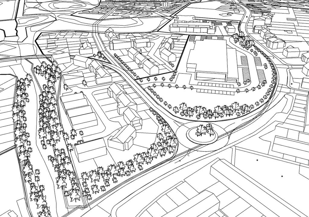
14 5.0 SITE CONDITIONS Summary Opportunities and Constraints 1. Access for vehicles and pedestrians could be achieved in several locations along Crouch House Road. 2. Good opportunity exists to integrate high quality pedestrian links into the existing network. One such opportunity is to provide an additional link to the PROW (SR606) to avoid the need to use an alley way to the rear of houses in Springfield Road. 3. The topography of the site varies, which means that a well-designed housing scheme could maximise the use of the level changes to create a subtle and non-intrusive extension to the town, whilst still maintaining the open character and any landscape views. 4. A large proportion of Edenbridge is situated within areas at significant risk of flooding, the site falls entirely within Flood Zone 1 and could be delivered safely with a dry access unlike other extension locations to the south or east of the town. 5. There are listed buildings close to the site, including The Lodge, Crouch House and Skeynes all of which are Grade II listed. Due regard has been paid to the protection of their setting in the development of the masterplan. 6. Buffer zones are required to prevent development around the three ponds. 7. Mature trees exist around these ponds and are to be retained along with trees running down the western boundary. 8. Opportunities exist to link with the existing Public Rights of Way and provide future residents with strong links to both the town and countryside. 14 Summary Opportunities and Constraints Plan LAND WEST OF CROUCH HOUSE ROAD, EDENBRIDGE I VISION DOCUMENT - SEPTEMBER 2018 WATES DEVELOPMENTS

15 6.0 CONCEPT MASTERPLAN Concept Masterplan To assist with the plan making process a concept masterplan has been provided to help emphasise how the site could be developed. Detailed proposals have not been agreed and any future scheme would be subject to further engagement with the local community, the Town Council and Sevenoaks District Council. 15

16 7.0 LAND USE The land in Wates Developments control amounts to some 18.4 ha. The concept masterplan subdivides into development parcels and considering land to be retained to provide landscape buffers, ecological areas and open space, the developable area is in the region of 14 hectares. Red Line A Medical Hub B Specialist Care C Independent Living D Residential E Open Space and Play Space Access and Structural Landscaping 18.4 ha 1.2 ha 0.6 ha 1.8 ha 10.7 ha 5.7 ha 0.2 ha 16 Zoning Plan LAND WEST OF CROUCH HOUSE ROAD, EDENBRIDGE I VISION DOCUMENT - SEPTEMBER 2018 WATES DEVELOPMENTS


17 8.0 NEW HOMES The scheme presents the potential for approximately new homes to meet a range of local needs. Residential development would include market homes, homes suitable for downsizers, retirees and up to 40% affordable housing. A range of densities are proposed in order to knit in with the existing settlement. Building heights would vary between one and two and a half storeys in response to the surrounding character and site topography. Suggested residential density/ character areas 17


18 9.0 RETIREMENT LIVING Result from a local Needs Assessment clearly indicates a requirement for additional specialist provision within the District and a demand locally for increased provision and choice with an insufficient supply locally. The concept plan therefore brings forward the potential to include a new care facility that could comprise a care home and extra care apartments complete with shared community facilities set within high quality landscaped grounds. The scheme also shows potential for independent living through the provision of bungalows. Homes will be built and equipped to the highest specifications. 18 Specialise Accommodation for older people - District wide Benefits Release of under occupied, larger family housing. Reduced pressure on healthcare by reducing the length of stay in hospitals. Allowing people to retain independence for as long as possible. Economic benefits including the creation of a number of secure long-term jobs, that will provide care and services over a 24 hour period, at a range of scales and grades. Meeting people s care needs in their own home and tailored to their individual requirements. Avoiding the necessity for premature occupation of residential care home facilities. Enabling ageing in place as care needs increase, residents can remain in the same accommodation thereby receiving continuity of care in familiar surroundings. Local Benefits Provision of a purpose-designed community within which the leisure and community facilities help foster social integration and alleviate potential isolation. Improving the choice of specialist accommodation and care for people in the locality. Land available for the provision of a new medical hub to serve the wider community as well as the proposed new development. Opportunity for membership to use the communal facilities delivered as part of the specialist housing for older people element of the site Local choice of alternative specialist housing other than the existing enhanced sheltered housing scheme locally. seek this elsewhere remote and unfamiliar. LAND WEST OF CROUCH HOUSE ROAD, EDENBRIDGE I VISION DOCUMENT - SEPTEMBER 2018 WATES DEVELOPMENTS
 decided to progress with its preferred option of a combined hospital and General Practice surgery with existing services to be")


19 10.0 MEDICAL HUB The site is ideally located to the west of Edenbridge town centre and large enough to accommodate a new medical hub for Edenbridge. In 2017, the NHS West Kent Clinical Commissioning Group (CCG) decided to progress with its preferred option of a combined hospital and General Practice surgery with existing services to be consolidated. This option was backed by the board of Kent Community Health NHS Foundation Trust and by the GP partners of Edenbridge Medical Practice. The concept allocates a minimum of 1.2 hectares for building, parking and potential expansion. This hub will include facilities such as a general clinic, outpatient day services and community nursing services for dementia conditions. A high proportion of residents within Edenbridge would reside within a reasonable walking distance of the medical hub, should it be located within the proposed development. Maximum of 140 parking spaces + disabled spaces + ambulance drop off. Vehicular and pedestrian access. Close to the centre of town s population. Land viable to be built on: not on flood plain or contaminated. Potential for co-location with a dental practice/ pharmacy. Proximity to specialist care. 19

20 20 Indicative Street Scene LAND WEST OF CROUCH HOUSE ROAD, EDENBRIDGE I VISION DOCUMENT - SEPTEMBER 2018 WATES DEVELOPMENTS


21 11.0 OPEN SPACE The Council s Open Space Strategy 2018 highlights current issues with open space and play space across the district. In response, the proposal would promote inclusion of the following: A new Local Equipped Area of Play. New amenity green space together with a series of pocket parks. Protection and enhancement for existing wildlife and natural features including trees, ponds, hedgerows and improved semi - natural green space. New planting along site boundaries to provide screening for existing properties,enhance biodiversity and to reinforce existing tree lines and hedgerows. Landscaped pedestrian routes through the scheme linking to existing Public Rights of Way and the wider countryside. A series of attenuation ponds and tanks will be used for surface water management. Retained trees and hedgerows providing a strong and defensible barrier against future expansion of the site to the west. Landscaped gardens as part of a retirement village. 21
22 12.0 PROPOSED ACCESS 22 The site represents a logical extension to the existing town centre and has the capacity to provide growth in a sustainable way, with excellent links to existing shops, services, employment opportunities and key transport links. Vehicular access will be taken from Crouch House Road, in the form of a three-arm roundabout. This will be the primary access to the site, with circular routes provided within the internal layout to allow for emergency access. A secondary access could also be provided for direct access to the medical hub and specialist care facility. New footpaths would connect and make use of existing routes and Public Footpaths. It is considered that the highway network within proximity of the site is appropriate to accommodate the additional vehicle trips associated with the scheme without leading to detrimental impacts. This will be explored further as the wider proposals come forward, alongside any options for improvements. Consideration will be given to improving local bus services operating along Crouch House Road, in particular through increasing service frequency. Bus stop waiting facilities will also be enhanced where possible. Consideration will be given to providing an additional link to Public Footpath SR602, to avoid the need to use an alley to the rear of the houses in Springfield Road. The possibility of providing a footway across the site frontage on the western side of Crouch House Road will be explored. In particular, consideration will be given to localised widening along Crouch House Road and the potential to introduce parking bays in locations where this would have a minimal effect on existing residents. Proposed Access LAND WEST OF CROUCH HOUSE ROAD, EDENBRIDGE I VISION DOCUMENT - SEPTEMBER 2018 WATES DEVELOPMENTS
23 13.0 IMPACT ON THE GREEN BELT Paragraph 138 of the NPPF (2018) states that when drawing up or reviewing Green Belt boundaries, the need to promote sustainable patterns of development should be considered. Where it has been concluded that it is necessary to release Green Belt land for development, plans should give first consideration to land which has been previously-developed and/or is well-served by public transport. They should also set out ways in which the impact of removing land from the Green Belt can be offset through compensatory improvements to the environmental quality and accessibility of remaining Green Belt land. Wates site is highly accessible and located in proximity of a range of public transport opportunities. Furthermore, opportunity exists to enhance access to what is otherwise a privately owners site and ecological enhancements will be integral to the scheme. From a wider perspective, paragraph 134 states that the Green Belt serves five purposes: To check the unrestricted sprawl of large built-up areas The site is also located adjacent to the settlement boundary of Edenbridge, so development on this site would not result in sporadic or isolated housing. Instead, it would create a logical and well-planned extension to the existing built development with a defensible western boundary. Furthermore, Edenbridge as a town is semi-rural in nature and does not represent a large built up area that needs to be contained in the same way as those such as Swanley or the London Boroughs that are far more urban in character. To prevent neighbouring towns merging in to one another The closest major settlements are located over the Surrey/Sussex borders in Lingfield, Dormansland, East Grinstead and Oxted. All of these settlements are located more than 5km from the site. If the Green Belt boundary was to be amended to allow development of the site there would remain at least 5km separation between the settlements. To assist in safeguarding the countryside from encroachment Encroachment can be defined as the presence of development within the Green Belt not connected or adjacent to a built-up area. As the site borders the currently defined settlement confines, development on this site would form a natural and logical extension rather than represent encroachment into the countryside. More importantly, it would protect genuine areas of open land from risk of development. To assist in urban regeneration, by encouraging the recycling of derelict land Given the lack of brownfield opportunities Green Belt land is needed and therefore this purpose is superseded by the requirement. To preserve the setting and special character of historic towns Edenbridge is a settlement that has historically expanded in erratic patterns. This largely is a result of the heavily constrained areas at risk of flooding and because of redevelopment opportunities that have arisen on former commercial land. Land to the west of Edenbridge has been the focus for the land taken out of the Green Belt and safeguarded previously and now represents the most sustainable area for growth. Whilst there are some sporadic listed buildings close to the site, the setting and historic integrity of these buildings can be adequately protected. 23
24 14.0 WHY LAND WEST OF CROUCH HOUSE ROAD? 1. The site does not sit within any AONB National planning policy is clear that development should be prioritised in less environmentally sensitive areas. 2. New housing without the flood risk the site falls wholly within Flood Zone 1 an area with lowest risk of flooding from rivers. Edenbridge has a history of flooding and so it is imperative that housing growth is on sites that do not carry this risk. 3. Easy accessibility to the town the site is an ideal location to deliver housing expansion to the town. It is well-positioned to access the full range of shops, services and other facilities and has a long road frontage ensuring safe access can be provided to and from the site. 4. Essential new infrastructure for Edenbridge notably the land needed for new health facilities including a new medical hub. 5. Protection for Edenbridge s open spaces development here would ensure growth is delivered in a planned and sustainable manner alongside essential infrastructure, as opposed to ad hoc infill of existing open spaces. 8. Development that is both available and deliverable the entire site is under just two ownerships and could begin delivering housing within a five year period. Both landowners would work together with Wates to deliver a comprehensive and sensitively designed masterplan. Whilst Edenbridge is undoubtedly suitable for growth, genuinely sustainable development opportunities are in short supply. Development to the north of the town would be too remote and inaccessible in respect of the main town centre uses, whilst land south and east is located within Flood Zones that make them unsafe for new housing. These constraints naturally mean that development to the west of Edenbridge, close to the town centre, is the most sustainable location for growth. We conclude that land promoted at Crouch House Road should be included as a future housing allocation. 6. Development that is flexible to local needs The site would deliver balanced growth to Edenbridge, providing much-needed new homes including affordable homes, homes for downsizers and retirement accommodation Natural defensible boundaries - in the form of dense hedging and public open space the development would not lead to sprawl. We would ensure appropriate buffers are provided in the form of planting and buffers between the existing properties along land to the west of the development. LAND WEST OF CROUCH HOUSE ROAD, EDENBRIDGE I VISION DOCUMENT - SEPTEMBER 2018 WATES DEVELOPMENTS


25 15.0 CONSULTATION Wates is committed to hearing the views of local people and giving everyone the opportunity to comment on the emerging proposals. Various communication mechanisms were used to raise awareness of the emerging proposals and drop-in event, including: a flyer, a letter issued to neighbours and key stakeholders; editorial coverage and an advert in the local press; a consultation website; and a presentation to Edenbridge Town Council. Public Consultation - 18th August 2018 Wates Developments held a public exhibition on draft proposals for land west of Crouch House Road at Rickards Hall in Edenbridge on Saturday 18 August. A feedback form was available at the exhibition for attendees to provide comments on the plans ahead of Wates submitting a bid for the site to be included in Sevenoaks District Council s New Local Plan. A consultation website (www. watesedenbridge.co.uk), hosting information about the draft proposals and incorporating an online feedback form, was also set up and promoted throughout the consultation. Approximately 250 people attended the public exhibition. The feedback received during the consultation was used to help inform our updated masterplan. Much of the feedback received regarding new homes was useful in determining the size and type of homes wanted by the people of Edenbridge. The most popular preferences were 2-3-bedroom homes, bungalows, and homes for first-time buyers. Many residents supported proposals for retirement living and homes for those wishing to downsize. The feedback demonstrated that there are certain key issues of concern for respondents, in particular the impact of development on Crouch House Road itself, in terms of traffic, parking and necessary improvements. Other concerns related to public transport and necessary town centre improvements. We have considered all feedback received over the course of the consultation period and ensured that, where possible, the points raised have been addressed in the vision for the site. 25


26 16.0 ABOUT WATES DEVELOPMENTS Above all, its about people Wates Developments is an expert in delivering residential planning consents throughout Southern England and forms part of the Wates Group founded in Today the family business, now led by the fourth generation, is one of the largest privately owned development and construction companies in the UK. The importance of community and sustainability is at the very core of the business and we see every development as an opportunity to enhance and improve. By engaging with local people, understanding their needs and aspirations for the future of their environment, we are able to build a picture that informs how a scheme is put together. Wates Developments open and consultative approach with the community is consistent with the highly regarded corporate responsibility credentials of the Wates Group. Wates Giving is a charitable programme set up by the family with the aim of strengthening the role business has to play in society, focused on making a real difference to the communities in which we live, work and build. Since 2008, Wates Giving has invested over 8m in local initiatives through five themes: Education; Employment and Training; Social Enterprise; Sustainability; and Community Building. Wates Group has twice won the Queen s Enterprise Award, recognition of the commitment of all to working closely in our communities. wates.co.uk 26 LAND WEST OF CROUCH HOUSE ROAD, EDENBRIDGE I VISION DOCUMENT - SEPTEMBER 2018 WATES DEVELOPMENTS
27 27
Welcome to our exhibition
 Welcome to our exhibition The Homes & Communities Agency (HCA) welcomes you to this public exhibition explaining our proposals for the redevelopment of the former Lea Castle Hospital site. About the Homes
Statement of Community Involvement LAND OFF SOUTHDOWN ROAD HORNDEAN, HAMPSHIRE
 LAND OFF SOUTHDOWN ROAD HORNDEAN, HAMPSHIRE CONTENTS Page 1. Introduction 3 2. Pre-application Discussions 4 3. The Consultation Process 5 4. Consultation Feedback 7 5. Responses to Consultation Feedback
WELCOME. Land North of STEVENAGE. We would like to thank you for attending our public exhibition today.
 WELCOME We would like to thank you for attending our public exhibition today. The purpose of this event is to share our proposals and hear your thoughts on our ideas. Members of the project team are on
Welcome to our public exhibition
 About Our Scheme Welcome to our public exhibition This exhibition gives you the chance to view and comment upon our emerging proposals for a new residential development of 68 new homes on the site of the
Public Consultation. Land at Monks Farm, North Grove. Welcome
 Welcome Welcome to our public exhibition for development on Land at Monks Farm, orth Grove. Gallagher Estates and Gleeson Strategic Land are preparing an outline planning application for new homes, open
Welcome to our public exhibition
 About our development Welcome to our public exhibition This exhibition gives you the chance to view and comment on our proposals for a new residential development of 165 high-quality homes, along with
LEEDS SITE ALLOCATIONS PLAN MATTER 3 GREEN BELT KCS DEVELOPMENT AUGUST 2017
 LEEDS SITE ALLOCATIONS PLAN MATTER 3 GREEN BELT KCS DEVELOPMENT AUGUST 2017 Smith Limited Suite 9C Joseph s Well Hanover Walk Leeds LS3 1AB T: 0113 2431919 F: 0113 2422198 E: planning@peacockandsmith.co.uk
Welcome to our Public Consultation
 About our development This exhibition gives you the chance to view and comment on our emerging plans for a proposed residential development located on land to the West of Alwyn Road, Rugby. Welcome to
Welcome to our exhibition
 Welcome to our exhibition housing development A46 Wildmoor Alcester Road Canal Quarter A422 Town Centre housing development Warwickshire-based IM Properties, one of the UK s largest privately owned property
SOUTH EAST LINCOLNSHIRE LOCAL PLAN: HOUSING PAPER DONINGTON (JUNE 2016)
") SOUTH EAST LINCOLNSHIRE LOCAL PLAN: HOUSING PAPER DONINGTON (JUNE 2016) 1 DONINGTON S PLACE IN THE SPATIAL STRATEGY 1.1 Policy 2 of the South East Lincolnshire Local Plan 2011-2036 Draft for Public Consultation
SOUTH EAST LINCOLNSHIRE LOCAL PLAN: HOUSING PAPER DONINGTON (JUNE 2016) 1 DONINGTON S PLACE IN THE SPATIAL STRATEGY 1.1 Policy 2 of the South East Lincolnshire Local Plan 2011-2036 Draft for Public Consultation
Welcome. Proposals for land at Smug Oak Lane BRICKET WOOD
 Proposals for land at Smug Oak Lane BRICKET WOOD Previous Linden Homes and Wates Developments scheme Welcome Welcome to Linden Homes and Wates Developments public exhibition. Working together as joint
Kibworth Harcourt. Introduction. Introduction
 Introduction Introduction Welcome to this public exhibition on the proposals for the delivery of new homes on land at The Kibworths. The purpose of today s exhibition is to give you the opportunity to
8.0 Design and Form of Development 43/
 42/ 8.0 Design and Form of Development 43/ Rothwells Farm, Golborne/ Development Statement Figure 7. Site Constraints Key 44/ Site Boundary 360 Bus Route/Stops Existing Trees Underground Water Pipe Sensitive
WELCOME LAND EAST OF TYE LANE, WALBERTON. Above all, it s about people
 WELCOME Welcome to this public exhibition relating to our draft residential proposals for the land east of Tye Lane, Walberton. Today gives you the opportunity to have an active role in shaping these ideas
ABOUT CALA HOMES CALA HOMES
 WELCOME Welcome to this public consultation event for our proposed development on land to the east of Salisbury Road, in Hungerford. Thank you for taking the time to come along today. Homes and Wates Developments
Development of land adjacent to Braggs Farm Lane and Rumbush Lane, Dickens Heath. Welcome. Today s exhibition. The proposal site
 Welcome Welcome to this event to discuss the development of land adjacent to Braggs Farm Lane. is currently in the preliminary stages of designing proposals to sensitively develop this site with high-quality
Neighbourhood Planning Local Green Spaces
 Neighbourhood Planning Local Green Spaces Introduction... 2 1. Why green space is important... 4 2. Neighbourhood plans and green space... 6 3. Evidence... 8 Statutory designations... 9 Green space audit...
Carterton Construction Ltd is bringing forward plans for up to 85 new family homes and extra care facilities on land east of Burford.
 Welcome Carterton Construction Ltd is bringing forward plans for up to 85 new family homes and extra care facilities on land east of. We are at the early stages of designing our proposals and have a number
NORTH CIRCULAR ROAD - REGENERATION IN ACTION
 NORTH CIRCULAR ROAD - REGENERATION IN ACTION Notting Hill Housing is a social enterprise which has been at the forefront of vibrant urban regeneration since 1963. Notting Hill has over 25,000 homes across
Welcome. Site/11/04. Site/11/03. Proposed Site. 11,400 new homes needed in east Cambs
 Welcome Welcome to our consultation on our proposals for new homes on land north east of Soham Road, Fordham. Members of the project team are available to answer any questions you have and listen to feedback.
1.0 INTRODUCTION. Brantham Industrial Area Regeneration - Factory Lane - Brantham
 1.0 INTRODUCTION Welcome to this exhibition of our proposals for the regeneration of the Brantham Industrial Area located off Factory Lane in Brantham. This presentation will give you an opportunity to
WELCOME GYPSY LANE. Wider Site Location plan. Proposals for the development of LAND OFF FOXLYDIATE LANE WEBHEATH. Proposals for the development of
 WELCOME The developers are preparing an outline planning application for a residential led development and need the community s views in order to develop the proposals further WHAT IS PROPOSED? A high
STATEMENT OF OBJECTION TO THE PROPOSED DEVELOPMENT OF LAND AT CHURCH CLIFF DRIVE FILEY
 STATEMENT OF OBJECTION TO THE PROPOSED DEVELOPMENT OF LAND AT CHURCH CLIFF DRIVE FILEY You will be aware that Scarborough borough council have adopted a new local plan that includes land at Church Cliff
HARDWICK GREEN, King s Lynn. Welcome to our Exhibition. What are your views? Introduction to the site and proposals. About us
 HARDWICK GREE, King s Lynn Welcome to our Exhibition Welcome to our exhibition, which is being held to provide you with the opportunity to understand and comment upon our proposals for new residential
WELCOME. ORPINGTON. Welcome to this exhibition of our proposals for the redevelopment of Bassetts Campus.
 WELCOME Welcome to this exhibition of our proposals for the redevelopment of Bassetts Campus. The site has been vacant since 2013 and in 2014 NHS Property Services previously brought forward plans for
Land at Rampton Road. Cottenham
 Land at Rampton Road Cottenham Introduction TEP is preparing an outline planning application for 54 dwellings on 6.9 hectares of land adjacent to Rampton Road, Cottenham on behalf of the owners Cambridgeshire
Site ref: AS06 Site Name or Address: Murreys Court, Agates Lane
 Site ref: AS06 Site Name or Address: Murreys Court, Agates Lane Proposed Land Use: Total Site Area (Ha): Housing 1.85 Ha Description: It is understood that the owner has no plans to dispose of the site
WHITELEY TOWN COUNCIL NORTH WHITELEY DEVELOPMENT SEPTEMBER 2014
 WHITELEY TOWN COUNCIL NORTH WHITELEY DEVELOPMENT SEPTEMBER 2014 Dear Resident This Special Edition of the Whiteley Voice which has been prepared in conjunction with the North Whiteley Consortium is to
Longbridge Town Centre Phase 2 Planning Application
 Longbridge Town Centre Phase 2 Planning Application Non-Technical Summary of the Environmental Statement December 2013 Introduction A full application for Planning Permission has been submitted to Birmingham
Newcourt Masterplan. November Exeter Local Development Framework
 Newcourt Masterplan November 2010 Exeter Local Development Framework Background The Exeter Core Strategy Proposed Submission sets out the vision, objectives and strategy for the development of Exeter up
DUNSFOLD NEIGHBOURHOOD PLAN Site Selection Policies
 DUNSFOLD NEIGHBOURHOOD PLAN Site Selection Policies The criteria for assessing sites for future housing and business development in Dunsfold are set out below. (Development criteria, covering what it is
Gresley Park, Hertfordshire
 Gresley Park, Hertfordshire Delivery Statement January 2016 CONTENTS Executive Summary 2 1.0 Introduction 4 2.0 Planning Policy Context 5 3.0 Delivery 6 4.0 Physical Context 7 5.0 Concept Masterplan 9
INTRODUCTION NORTH HEYBRIDGE GARDEN SUBURB
 INTRODUCTION This event is being hosted by the promoters of the proposed North Heybridge Garden Suburb who are working with Maldon District Council and other key stakeholders on the preparation of a comprehensive
Oxford Green Belt Study. Summary of Final Report Prepared by LUC October 2015
 Oxford Green Belt Study Summary of Final Report Prepared by LUC October 2015 Project Title: Oxford Green Belt Study Client: Oxfordshire County Council Version Date Version Details Prepared by Checked by
University Park, Worcester Non Technical Summary December 2011
 University Park, Worcester Non Technical Summary December 2011 Introduction UW Wrenbridge LLP, a Joint Venture Company of the University of Worcester and Wrenbridge Land Ltd (the Applicants ) intend to
Frequently Asked Questions
 1. Where is Aylesbury Woodlands? Frequently Asked Questions Aylesbury Woodlands lies to the east of Aylesbury. It is bounded to the south by the A41. To the north is the Aylesbury Arm of the Grand Union
WELCOME. Olney Road, Lavendon INTRODUCTION. The Site. The Application. The Need for Housing. A Sustainable Location LAVENDON TURVEY OLNEY ROAD
 0 WELCOME INTRODUCTION Gladman Developments Ltd have successfully invested in communities throughout the UK over the past 0 years, developing high quality and sustainable residential, commercial and industrial
Land East of Cromwell Lane
 Land East of Cromwell Lane VISION DOCUMENT AUGUST 2016 The proposals for Land East of Cromwell Lane will be defined by existing landscape features, ensuring that the development offers a quality place
Site Assessment Technical Document Appendix A: Glossary
 Central Bedfordshire Council www.centralbedfordshire.gov.uk Site Assessment Technical Document Appendix A: Glossary July 2017 1.1.11-1 - ii Appendix A: Glossary Term Agricultural Land Classification AONB
New Homes at Winton East
 View toward Winton East from Caerketton Hill Aerial photograph of South Edinburgh: Winton East Site Location Indicative proposal Welcome Thank you for coming to the Winton East public exhibition. We would
Introduction. Welcome to this consultation regarding the draft redevelopment proposals for the former CeramTec factory on Sidmouth Road, Colyton.
 Introduction Welcome to this consultation regarding the draft redevelopment proposals for the former CeramTec factory on Sidmouth Road, Colyton. We are currently considering options for the mixed-use redevelopment
Public Consultation 23 January Peel Hall, Warrington Board 1. A message from Satnam... Site history...
 Board 1 A message from Satnam... Thank you for attending today s public consultation about proposals to develop a new residential neighbourhood at. The display boards show why the development is needed
Neighbourhood Plan Representation
 Date: 10 th November 2017 Neighbourhood Plan Representation Land to the east of Callow Hill Road, Alvechurch Introduction This representation has been prepared by RPS Planning and Development on behalf
INTRODUCTION. Land south of Bishopswood Lane, Tadley
 0 INTRODUCTION THE SITE Introduction Gladman Developments Ltd. has successfully invested in communities throughout the UK over the past 0 years, developing high quality and sustainable residential, commercial
WELCOME TO THE NEW WILTON PARK
 WELCOME TO THE NEW WILTON PARK VISION HISTORY OF WILTON PARK TOWARDS A PLANNING APPLICATION Our objective is to create a truly outstanding environment at Wilton Park. At the heart of our proposals is a
Story Homes. Land at Thirsk Road, Kirklevington. An Introduction to Story Homes. Our Foundations. Commitment to Consultation.
 Story Homes An Introduction to Story Homes Founded by Fred Story in 1987, Story Homes has a long and successful reputation of building high quality and high specification homes. The family owned business
Welcome. Land adjacent Sandy Lane WALTHAM CHASE THE PROPOSED SITE
 Land adjacent Sandy Lane WALTHAM CHASE Existing Linden Homes developments Welcome Welcome to Linden Homes Southern s ( Linden ) public exhibition about its proposals for a range of high-quality homes for
Former Temple Cowley Pools, Oxford TEMPLE COWLEY LIBRARY * ELEVATION SHOWN IS INDICATIVE AND SUBJECT TO FINAL DESIGN AND AGREEMENT.
 OPEN SPACE TEMPLE COWLEY LIBRARY library beyond Proposed apartments Proposed apartments Proposed houses Temple Road * ELEVATION SHOWN IS INDICATIVE AND SUBJECT TO FINAL DESIGN AND AGREEMENT. * Welcome
The journey so far. The new masterplan for Dargavel Village
 The journey so far Our vision for Dargavel Village began over ten years ago when the original masterplan for transforming the former Royal Ordnance Factory site into a thriving community was established.
The Fairfield Partnership Vision for North-East Elsenham
 The Fairfield Partnership Vision for North-East Elsenham August 2009 Frequently Asked Questions Who is The Fairfield Partnership? The Fairfield Partnership is a joint venture between Marchfield Developments
Land at Fiddington Hill Nursery, Market Lavington
 Land at Fiddington Hill Nursery, Market Lavington Briefing Report for Market Lavington Parish Council Persimmon Homes (Wessex) April 2016 Background This brief report has been prepared following the Market
SPG 1. * the northern and western sections which are open fields used for pasture and grazing;
 SPG 1 1.0 INTRODUCTION This development brief is based on the allocation of the Priors Hall site for employment and countryside recreational purposes in the Corby Borough Local Plan. The brief is intended
Rochford District Council Allocations Development Plan Document: Discussion and Consultation Document Sustainability Appraisal
 Option SWH1 Balanced Communities Option SWH1 1 To ensure the delivery of high quality sustainable communities where people want to live and work Will it ensure the phasing of infrastructure, including
WELCOME. North East Haverhill. The Planning Process
 WELCOME North East The site to the North East of, known as Great Wilsey Park, is identified by St Edmundsbury Borough Council in its Core Strategy as capable of delivering a Sustainable Urban Extension.
BRIDGE OF DON MASTERPLAN & PLANNING SUMMARY
 BRIDGE OF DON MASTERPLAN & PLANNING SUMMARY SITE LOCATION The site of the existing AECC lies in an area of predominately residential and business use in Bridge of Don and extends approximately 50 acres.
Schedule of Planning Applications Committee Date: 23 May Reference: 06/17/0726/F Parish: Hemsby Officer: Mr J Beck Expiry Date:
 Schedule of Planning Applications Committee Date: 23 May 2018 Reference: 06/17/0726/F Parish: Hemsby Officer: Mr J Beck Expiry Date: 22-05-2018 Applicant: Proposal: Site: Mr Gillett Change of use to the
Droitwich Spa 6. Reasoned Justification
 87 Droitwich Spa 6 Reasoned Justification 6.1 Droitwich Spa is identified in the settlement hierarchy (Policy SWDP1) as a main town being the largest settlement in Wychavon District with an estimated population
INTRODUCTION. Land West of Main Road, Stanton Harcourt THE SITE. Why is the Site Suitable for Development?
 0 INTRODUCTION THE SITE Application Boundary Gladman Developments Ltd has successfully invested in communities throughout the UK over the past 0 years, developing high quality and sustainable residential,
Chapter 2: OUTLINE PLANNING APPLICATION PROPOSALS. A New Garden Neighbourhood Matford Barton 17
 Chapter 2: OUTLINE PLANNING APPLICATION PROPOSALS A New Garden Neighbourhood Matford Barton 17 2.1. SUMMARY AND STATUS OF THE PROPOSALS 2.1.1. The parameter plans and associated wording in this chapter
Response to the London Bridge Area Vision and Site Allocations within the New Southwark Plan
 1 Melior Place London SE1 3SZ 020 7407 4701 teamlondonbridge.co.uk info@teamlondonbridge.co.uk 28 April 2017 Response to the London Bridge Area Vision and Site Allocations within the New Southwark Plan
Linden Homes Proposals for land off Ringwood Road, Verwood
 Welcome Welcome to Linden Homes first public exhibition displaying proposals for new homes on land off Ringwood Road in Verwood. Award-winning house builder Linden Homes, part of the Galliford Try Group,
Our City Centre is a vibrant, creative and welcoming destination, with a modern business, cultural, shopping, leisure and residential offer
 3. Sheffield in 2034 Our City sits at the heart of a strong, distinctive and internationally successful City Region economy which supports innovation and enterprise Our City Centre is a vibrant, creative
CENTRAL BEDFORDSHIRE COMMITTED TO WORKING TOGETHER WITH LOCAL COMMUNITIES
 WELCOME Thank you for coming to our consultation event to find out more about our emerging proposals for Hayfield Park, a residential development jointly promoted by the Hayfield Consortium: Martin Grant
WELCOME. Welcome and thank you for visiting today.
 WELCOME Welcome and thank you for visiting today. Bellway Homes Ltd (Yorkshire) are preparing a reserved matters planning application for a residential development of 293 homes at land North of Yew Tree
Ashtead Neighbourhood Forum Site Assessment AS07 Old Chalk Pit, Pleasure Pit Road. Site ref: AS07 Site address: Old Chalk Pit, Pleasure Pit Road
 Site ref: AS07 Site address: Old Chalk Pit, Pleasure Pit Road Proposed Land Use: Total Site Area (Ha): Housing 0.7ha Description: The site was formally an old chalk pit that has been partially filled and
Sustainability Statement. Whitby Business Park Area Action Plan
 Sustainability Statement Whitby Business Park Area Action Plan November 2014 Contents Page 1. Introduction 1 2. Scoping 3 3. Sustainability Appraisal of Options 6 4. Assessment of Draft Area Action Plan
Replacement Golf Course Facilities and Residential Development, Churston. Environmental Statement Non-Technical Summary
 Replacement Golf Course Facilities and Residential Development, Churston Environmental Statement Non-Technical Summary July 2011 Reproduced from the Ordnance Survey s map with the permission of the Controller
DESIGN & ACCESS STATEMENT
 DESIGN & ACCESS STATEMENT Land to the South East of the A495, Bronington Erection of 31 Dwellings (27 dwellings and 4 bungalows including 4 Affordable Dwellings), Realignment and Improvements to A495 (including
Haydock Point. Welcome
 Welcome Peel Logistics Property, alongside Peel Land and Property, is preparing a planning application for Haydock Point, a high-quality logistics park east of Haydock. The purpose of this exhibition is
DESIGN & ACCESS STATEMENT
 DESIGN & ACCESS STATEMENT January 2016 Contents Introduction section 1 Section 1 - Introduction Section 2 - Assessment Section 3 - Involvement Section 4 - Evaluation Section 5 - Design Section 6 - Layout
16. Peckham Peckham Area Vision
 16. 16.1. Area Vision 16.1.1. is: A lively town centre providing a range of daytime and night time activities on Rye Lane including a Library, a Leisure Centre and many independent retailers which specialise
CALA Homes is preparing a planning application for a development of up to 36 new homes, including a mix of properties to meet local demand.
 WELCOME Welcome to this public consultation event for our proposed development on land to the south of Twelve Leys in Wingrave. Thank you for taking the time to come along today. Homes is preparing a planning
LETTER OF OBJECTION LAND TO THE SOUTH WEST OF FORGE GARAGE, HIGH STREET, PENSHURST, KENT, TN11 8BU
 Senior Planning Officer Andrew Byrne Sevenoaks District Council Community & Planning Services PO Box 183 Argyle Road Sevenoaks Kent TN13 1GN 04 November 2011 Your Ref: 11/02258/FUL For the attention of
Toddington Central Bedfordshire Stage 3 Green Belt Study December 2017
 Toddington Central Bedfordshire Stage 3 Green Belt Study December 2017 Site: ALP086 - Middle Lakes, Toddington Site size (ha): 2.83 Site: ALP086 - Middle Lakes, Toddington Site size (ha): 2.83 Site description
Environmental and Landscape Mapping
 Environmental and Landscape Mapping In support of the Calveley Neighbourhood Plan November 2016 Project Name and Number: Calveley Neighbourhood Plan 16-025 Document Name and Revision: Environmental and
Alder View. Introduction. Alder View. Harwell. The Vision. The Team. Taylor Wimpey
 Introduction Welcome to the public exhibition for, a development by Taylor Wimpey on the land south of Grove Road,. This exhibition will provide an overview of the development proposals for the site and
Plumpton Neighbourhood Development Plan Revised Pre Submission Document - Regulation 14 Consultation
 REPRESENTATIONS... Plumpton Parish Council Plumpton Neighbourhood Development Plan Revised Pre Submission Document - Regulation 14 Consultation Representations submitted on behalf of: Cala Homes (South
Neighbourhood Planning Site Assessment Pro-forma and Guide Version 2
 Neighbourhood Planning Site Assessment Pro-forma and Guide Version 2 September 2014 Site HNP 006 Land East of Stanbridge Road and North of Lower Road 1. Background information Site location and use Site
Linden Homes Proposals for the Ridgewood Centre, Old Bisley Road, Frimley
 Linden Homes Welcome Welcome to our public exhibition. Today we are displaying draft proposals for a high quality residential redevelopment of land off Old Bisley Road, currently known as the Ridgewood
The Gwennap Parish Vision Statement
 QUICK GUIDE What is a Neighbourhood Development Plan? Ultimately it is a document used by developers or anyone wishing to submit a planning application that describes the vision, strategy, plans, regeneration,
PHASE III: Reserved Matters Submission
 Statement of Compliance with the outline approval for the proposed residential development of land at: BURGES LANE, WIVELISCOMBE PHASE III: Reserved Matters Submission Foreword Contents: This Statement
Welcome to our public exhibition
 About our scheme Welcome to our public exhibition Taylor Wimpey East Anglia intends to submit a detailed planning application for a new residential development of 39 high-quality homes at the B&M Concrete
CA//17/02777/FUL. Scale 1:1,250. Planning Services Canterbury City Council Military Road Canterbury Kent CT1 1YW
 O CA//17/02777/FUL Scale 1:1,250 Map Dated: 15/03/2018 Planning Services Canterbury City Council Military Road Canterbury Kent CT1 1YW AGENDA ITEM NO 16 PLANNING COMMITTEE APPLICATION NUMBER: SITE LOCATION:
Welford-on-Avon Neighbourhood Plan Consultation Event Sunday, 6 April Your name Your address
 Welford-on-Avon Neighbourhood Plan Consultation Event Sunday, 6 April 2014 Your name Your email address Please either: - complete this feedback form and put it in the box before leaving the Memorial Hall
ROCHFORD LOCAL DEVELOPMENT FRAMEWORK: Sustainability Appraisal/ Strategic Environmental Assessment. Rochford Core Strategy Preferred Options Document
 ROCHFORD LOCAL DEVELOPMENT FRAMEWORK: Sustainability Appraisal/ Strategic Environmental Assessment Non Technical Summary Rochford Core Strategy Preferred Options Document October 2008 SUSTAINABILITY APPRAISAL
Grantham Southern Quadrant Link Road Environmental Statement
 Grantham Southern Quadrant Link Road Environmental Statement Non Technical Summary Introduction Lincolnshire County Council (LCC) is submitting a planning application for the proposed implementation of
2014/0590 Reg Date 26/06/2014 Chobham
 2014/0590 Reg Date 26/06/2014 Chobham LOCATION: PROPOSAL: TYPE: APPLICANT: OFFICER: ASCOT PARK POLO CLUB, WESTCROFT PARK FARM, WINDLESHAM ROAD, CHOBHAM, WOKING, GU24 8SN Erection of a two storey detached
Former North Works, Lickey Road, Longbridge, Birmingham
 Committee Date: 14/11/2013 Application Number: 2013/06431/PA Accepted: 27/08/2013 Application Type: Full Planning Target Date: 26/11/2013 Ward: Longbridge Former North Works, Lickey Road, Longbridge, Birmingham
Welcome to this exhibition which shows emerging ideas for land owned by University of Bristol at Long Ashton.
 1 Introduction Welcome to this exhibition which shows emerging ideas for land owned by University of Bristol at Long Ashton. The University of Bristol owns a 170 acre site south of Long Ashton village
CALA HO ME S WELCOME
 WELCOME Welcome to this public consultation event for our proposed residential development of 56 high quality homes on land to the north east of Station Road in Earls Colne. Thank you for taking the time
Briefing Document of CNP. June 2017
 Cholsey Parish Council Cholsey Neighbourhood Plan Briefing Document of CNP June 2017 Cholsey Neighbourhood Plan Page! 1 of! 8 Cholsey Plan Briefing v1.4 Page Left Intentionally Blank Cholsey Neighbourhood
Blandford Forum Town Council, Blandford St Mary Parish Council and Bryanston Parish Council
 Blandford Forum Town Council, Blandford St Mary Parish Council and Bryanston Parish Council Blandford + Neighbourhood Plan 2 Pre-Submission Plan Consultation (November 2018) Representations submitted on
Anston House, Brighton
 Anston House, Brighton Welcome to our Anston House community consultation event Welcome to our first public consultation event regarding Anston House, Brighton. The site has been acquired by One Preston
SUB AREA 3 CENTRAL STRATFORD AND SOUTHERN QUEEN ELIZABETH OLYMPIC PARK
 191 ADOPTED LOCAL PLAN: THE SUB AREAS SUB AREA 3 CENTRAL STRATFORD AND SOUTHERN QUEEN ELIZABETH OLYMPIC PARK SECTION 12 Vision VISION Central Stratford and Southern Queen Elizabeth Olympic Park will become
EXTRACT FROM THE CUDDINGTON NEIGHBOURHOOD PLAN The Policies
 EXTRACT FROM THE CUDDINGTON NEIGHBOURHOOD PLAN The Policies Environment and Landscape Policy 1 - Landscape Setting Development should respect and wherever possible enhance the landscape setting of Cuddington
elbridge Core Strategy
 C elbridge Core Strategy Celbridge is designated as a Moderate Growth Town in the RPGs. The County Development Plan reinforces this designation in its settlement strategy. Moderate Growth Towns within
Land at BROOK STREET PROPERTIES TENCREEK FARM, LISKEARD. Environmental Statement: Non-Technical Summary
 BROOK STREET PROPERTIES TENCREEK FARM, LISKEARD Land at Environmental Statement: Non-Technical Summary Introduction Brook Street Properties is applying to Cornwall Council for outline planning permission
About 10% of the Borough's population lives in the seven rural parishes. Population figures from the 1991 census are given below:-
 8. THE DISTRICT VILLAGES 8.1 Population About 10% of the Borough's population lives in the seven rural parishes. Population figures from the 1991 census are given below:- Village No. of Persons Cottingham
ABBEY MANOR GROUP/SAINSBURY S SUPERMARKETS LTD
 ABBEY MANOR GROUP/SAINSBURY S SUPERMARKETS LTD Mixed Use Development including Business Park and Foodstore Land at Bunford Park, Bunford Lane, Yeovil Environmental Statement: Non-Technical Report June
Meridian Water Phase 1 Application
 Meridian Water Phase 1 Application MW11 Environmental Statement Non-Technical Summary London Borough of Enfield March 2016 Contents 1 Introduction 1 2 The proposed development 2 3 Evolution of the proposed