Source: Albemarle County Community Development 2011
|
|
|
- Claire Patrick
- 5 years ago
- Views:
Transcription

1 Source: Albemarle County Community Development 2011 DEVELOPMENT AREAS GOAL: Albemarle s Development Areas will be vibrant active places with attractive neighborhoods, high quality, mixed-use areas, thriving business and industry, all supported by services, infrastructure, and multimodal transportation networks. 8.1
2 Page intentionally left blank. 8.2
3 VISION: Albemarle County envisions a community with abundant natural, rural, historic, and scenic resources healthy ecosystems active and vibrant development areas a physical environment that supports healthy lifestyles a thriving economy and exceptional educational opportunity for present and future generations. Relationship to the Vision The Development Areas are the counterpart to Albemarle County s Rural Area. Honoring a rural heritage means new development occurs where infrastructure can support it - in the Development Areas. Good urban design and a strong economy make the Development Areas attractive and vibrant. Infra-structure, such as schools, libraries, sidewalks, and streets promote economic activity and create the places for old and new residents to live in close proximity to work. The Development Areas Introduction The Development Areas are the complement to the Rural Area. As the places for residential and business growth, they are to be attractive and vibrant communities where people live, work, and play. High quality design is expected to provide new development and redevelopment with an urban look and feel. Preserved streams and stream valleys as well as parks and trails provide respite and recreation. Existing neighborhoods are also key features of the Development Areas. Investments in infrastructure, such as water, sewer, sidewalks, and drainage, help to strengthen these neighborhoods. Improved street networks, connections to employment centers, and excellent school facilities help support residential development as well as encourage businesses to expand. Broadband services enhance livability and business development. Expectations for the Development Areas: 1. Master Plans for neighborhoods within the Development Areas; 2. High quality development through application of the Neighborhood Model principles; 3. Livability in existing neighborhoods; 4. Preventing premature expansion of the Development Areas; 5. Promoting density to help create new compact urban neighborhoods; 6. Compatible infill development; 7. Vibrant, active employment centers; 8. Collaboration with the City of Charlottesville, the University of Virginia, and the Town of Scottsville 9. Preserved natural systems; 10. Infrastructure that supports existing and new development; and 11. Opportunities for urban agriculture. When fully realized, the Development Areas will be dynamic and inviting areas helping to preserve the scenic agricultural Rural Area. 8.3
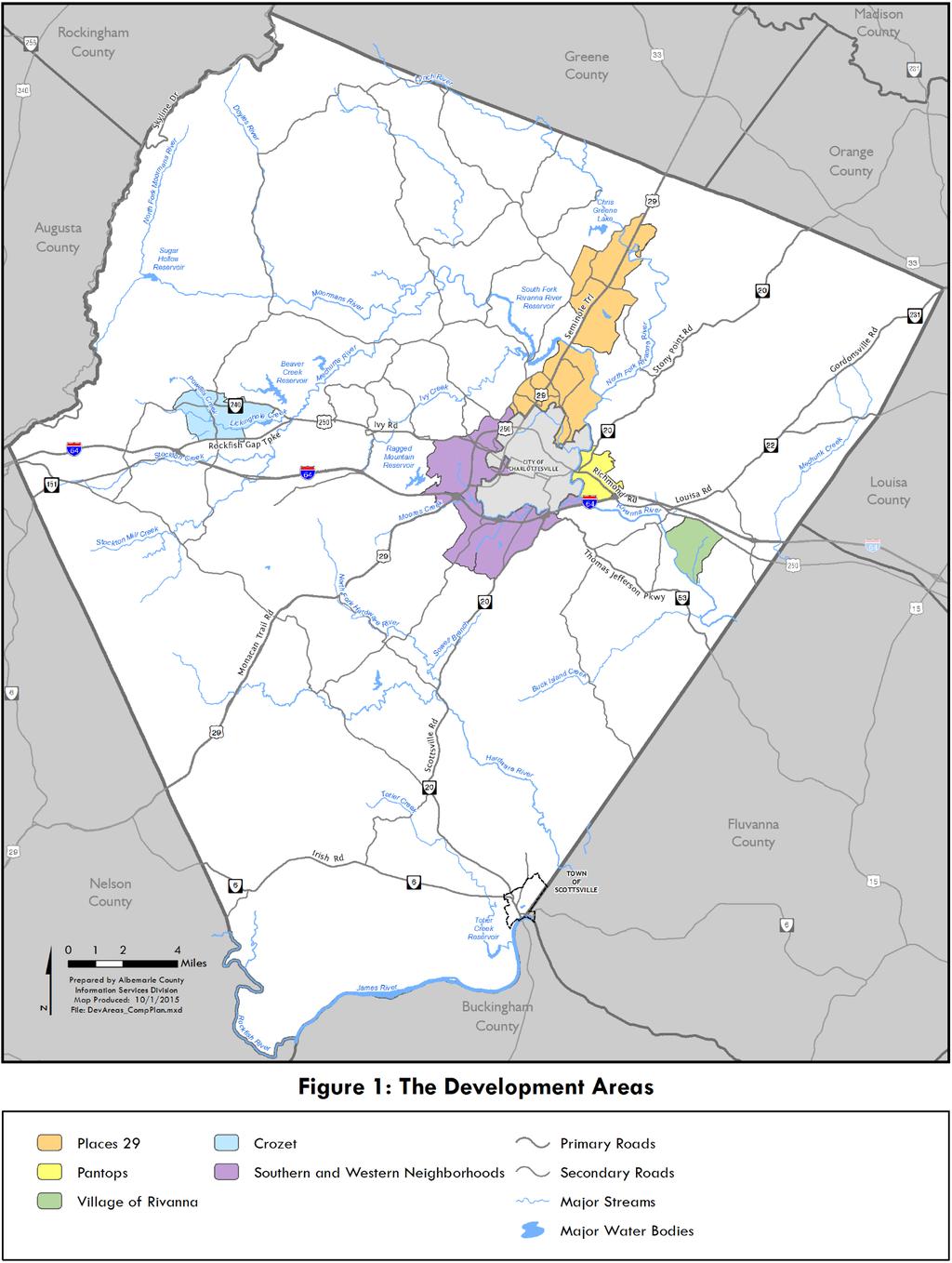
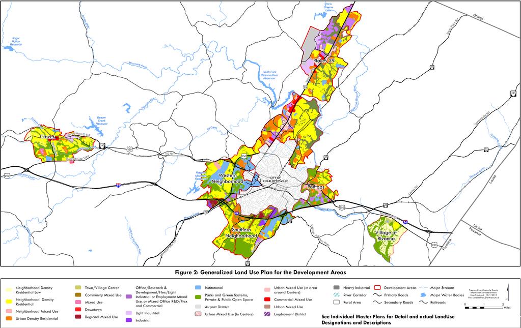
4 Master Plans for the Different Development Areas The County s Development Areas are distinctive places with separate identities. There are three types of Development Areas: The urban neighborhoods that surround the City of Charlottesville. Two satellite communities along Route 250 West and Route 29 North. The Village of Rivanna, which is mostly residential in nature but is intended to have a small mixed use village center. Names of Neighborhoods Places29 North Hollymead and Piney Mountain Places 29 South Neighborhoods 1&2 Pantops Neighborhood 3 Southern Neighborhood Neighborhoods 4&5 Western Neighborhood Neighborhoods 6&7 Community of Crozet Crozet Village of Rivanna Village of Rivanna Figure 1 shows the locations of the Development Areas. Although organized and named differently than they have been in the past, their historic identification numbers (i.e., Neighborhoods 1 7. etc.) are retained for statistical purposes and to describe subareas. The Land Use Plan on Figure 2 shows expected land uses in the Development Areas. It reflects the Land Use Plans from each Master Plan on a single map. The Land Use Categories and Guidelines found in the Appendix describe the expectations for each land use category. The Urban Neighborhoods: Places 29, Pantops, and the Southern and Western Neighborhoods The urban neighborhoods surround Charlottesville and relate most closely to the City. They are sometimes referred to as the urban area because, in many ways, the boundary between the City and the County is not discernible. Downtown Charlottesville is the geographic core of the entire area. Major employers, including UVA, are located in the City and in the urban neighborhoods. The Master Plans for Neighborhoods 1 and 2, as part of Places29, Pantops, and the Southern and Western Neighborhoods are found in the Appendix. The urban neighborhoods are expected to provide a full array of residential types and densities and look and feel like a city, all levels of retail, business, and industrial activities, along with regional employment centers. In addition, extensive urban and regional public facilities and services and infrastructure are to be provided. A mixture of housing types is expected and the urban areas are to be supported by transportation systems that include interconnected streets, pedestrian paths, bicycle circulation systems, and mass transit. Communities: Crozet, Hollymead and Piney Mountain Hollymead, Piney Mountain and Crozet are satellite communities. They are more distant from the City and the urban neighborhood and are expected to be able to operate independently. Like the urban neighborhoods, communities should have a mixture of housing types and be supported by transportation systems that include interconnected streets, pedestrian paths, bicycle circulation systems, and mass transit. Villages: Village of Rivanna Similar to the satellite communities, villages are located away from the urban neighborhoods; however, due to their large residential component, villages are not expected to operate independently. Residential density is expected to be lower than in the urban neighborhoods and communities. The range of uses, as well as provision of a variety of goods and services, is much less than what is expected in the urban neighborhoods or communities. 8.4
5 8.5
6 Page intentionally left blank. 8.6
7 Employment centers are not anticipated and industrial uses are not recommended. At present, the only village is the Village of Rivanna. The Village of Rivanna Master Plan is found in the Appendix. Villages are expected to have a variety of housing types, including single-family detached and attached units, townhouses, and garden apartments. Villages should have a center where neighborhood scale services are provided, such as convenience shopping, neighborhood retail and service uses, and medical and professional offices. Senior living may also be provided. In addition, restaurants and small lodging facilities, such as inns, are anticipated. Areas for development are shown in colors other than green on the Village Land Use Plan. Uses should be in accordance with the Land Use Categories and Guidelines found in the Appendix and the Master Plan. Overall residential density in villages should not exceed six (6) dwellings per acre; however, higher density in some areas can be provided if lower density is provided in other areas to average no more than six (6) units per acre. When the Village of Rivanna was initially created in 1989 and adopted into the Comprehensive Plan, the Board of Supervisors acknowledged that the Land Use Plan and zoning for the Glenmore development did not meet all of the expectations for new villages. At that time, the Village of Rivanna only provided an area of single-family homes with a significant recreational component and not many of the other features expected in a village. In 2002, after adoption of the Neighborhood Model and an extended public process, the Board of Supervisors approved a Comprehensive Plan Amendment to create a mixed use area in the Village for a variety of housing types and supporting commercial and retail uses for the Development Area. These changes have brought the Village of Rivanna closer in line with the original expectations for villages in the Development Areas. Villages are to be linked to the urban neighborhoods and the City of Charlottesville by multimodal roads with adequate capacity to safely and efficiently move residents conveniently between the village and the urban core. This guideline reflects a concern for using but not overloading the County s main roads, which are identified as arterials and major collectors in the transportation network, and a concern that minor collector and local roads not become subjected to traffic loads which they cannot tolerate, or which alters their character over time. In addition, villages should be served by more than one major road to provide for better access to and from the other neighborhoods. Although there is only one designated village at this time, other villages might be designated in the future. Future villages should be located where a village historically has been located or a settlement has existed and where public water and sewer can be made available. The proposed design should be a logical and harmonious outgrowth of what currently remains of that settlement. Within a proposed village, new development should emulate historic regional patterns of village density and design, such that the feel of a traditional village is created. The Neighborhood Model principles should be applied to new development in a village. When new villages are designated or the boundaries of existing villages are expanded, the impact of the planned expansion on existing development should be scrutinized. Plans to establish a new village or expand an existing village should be sensitive to the existing character of the surrounding Rural Area and the needs and wishes of those persons already living and owning property in the area. The effect on existing transportation infrastructure should also be a major consideration when planning for new development. 8.7
8 Page intentionally left blank. 8.8
9 8.9
10 Page intentionally left blank. 8.10
11 Urban Development Areas In 2011, Albemarle County established Urban Development Areas (UDAs) in accordance with the requirements in Virginia Code Urban Development Areas are places for compact, mixeduse urban development. They can accommodate years of growth and were established to improve coordination between transportation and land use. The County has two designated UDAs in the Development Areas. They are shown in the Places29 Master Plan and the Pantops Master Plan. The UDAs correspond with the priority areas shown in those Master Plans. As in all the Development Areas, the Neighborhood Model principles will be reflected in the UDAs. It is expected that state and local funding will be directed to UDAs where feasible. Although the County formally designated only two UDAs, all of the designated Development Areas meet the intent for UDAs. They are places for mixed-use, dense development that are anticipated to accommodate future residential and business growth. 8.11
12 Page intentionally left blank. 8.12
13 Objective 1: Use Master Plans to guide development and investment in each Development Area. Starting in 2004 with the Crozet Master Plan, Master Plans have been developed for all of the Development Areas. These Master Plans are currently being used to help guide decisions related to infrastructure, development, and other public improvements. Livability Project Charlottesville and Albemarle County will support neighborhoods and places that allow residents to live, work, and play near their homes and where attention to the character of new development and redevelopment enhances quality of life. Strategy 1a: Update Master Plans every five years to keep them current. The Master Plans are updated approximately every five years. Community Advisory Committees appointed by the Board of Supervisors typically guide the update process. Advisory Committee meetings typically provide the venue for updates to the Plans. As with the development of the Master Plans, the County s Growth Management Policy will continue to play a strong role in helping create attractive and active Development Areas for future populations. Application of the Neighborhood Model principles in the Master Plans and identification of needed infrastructure to improve neighborhoods will help guide changes to achieve vibrant livable areas. Strategy 1b: Continue to use Community Advisory Committees to help develop Master Plan updates, provide guidance on conformity of proposed projects with the Master Plan, assist in implementation of the Master Plan, and to act as a clearinghouse for information that is important to the Development Area. The first Community Advisory Committee was appointed by the Board of Supervisors in 2003 as the Crozet Master Plan was nearing completion. All Development Areas which have Master Plans have Advisory Committees. Appointment of an Advisory Committee(s) will be needed for the Southern and Western Neighborhoods when this Plan is adopted. Strategy 1c: To the extent possible, create uniformity in format and land use categories in Master Plans. To do this, the City and County will: At present, there are five Master Plans; however, uniformity is not present among them. As each Master Plan was created, the maps and format of the Master Plans changed somewhat. This situation has created difficulty for users of all of the plans because of lack of consistency. Uniformity in land use categories across Master Plans is needed to better convey expectations to all potential users of the Plan. With the advent of the Neighborhood Model and the first Crozet Master Plan in 2004, the County strove to bring the transect concept into master planning in each area. The transect is no longer used Encourage development and redevelopment in areas of the City identified for increased density and greater intensity of use, and in County Development Areas where appropriate in order to preserve open space, rural areas, and agricultural areas; Promote land use patterns that encourage multi-modal transportation opportunities; Coordinate City and County Development Areas land use and infrastructure policies; Maintain the distinct character of the Rural Areas; As a means of decision coordination, continue to actively participate in the Planning and Coordination Council (PACC), which brings City, County and University leaders together to discuss issues of common concern and interest; Establish policies that provide for consideration of development effects on the neighboring locality and shared community resources; and Create a unified vision for land uses adjacent to the Rivanna River that supports the river corridor as a destination while ensuring the protection and improvement of the river s water quality. 8.13
14 by name, but the concept of changing intensities of use remains. The concept is illustrated later in this document and referred to as a continuum in intensity of use. To the extent possible, the Land Use Categories and Guidelines table in the Appendix should be used for Master Plan updates. This table shows standard land use colors (yellow for low density residential, red for commercial, etc.), and the text describes expected future use of land. The color green shows the presence of sensitive environmental features, existing and proposed parks and greenways, and other areas that are not available for development. When land is assessed for future density or development, areas shown in green are not included in acreage available for development. Text in the Master Plans should continue to be used to indicate any special treatment for areas that are not recommended for the full spectrum of uses or the full range of density in a particular land use category. For example, in the Southern and Western Neighborhoods, the Fontaine Research Park is shown with the color denoting Office/R&D/Flex/Light Industrial. Text in that Master Plan says that use of land in that area is intended for office, research, and development. Flex and light industrial uses are not recommended. Objective 2: Create a physical environment that supports healthy lifestyles through application of the Neighborhood Model Principles The Neighborhood Model is a set of recommendations for creating livable urban neighborhoods and areas. Created by a diverse committee including residents, developers, development professionals, business professionals, and representatives of advocacy and neighborhood groups, it was adopted by the Board of Supervisors in The Neighborhood Model principles are those of new urbanism, and they represent the preferred model for development in the County s Development Areas. Sidewalks with street trees, curb and gutter on interconnected streets, parks and amenity areas, human-scaled architecture, and working with terrain are expectations for all new developments. Figure 3: Neighborhood Model Principles The Neighborhood Model continues to be the preferred form and Re-grading of Terrain of development and each proposed development should strive Clear Boundaries with the Rural Area to address as many of the Neighborhood Model principles in Figure 3 as possible. The twelve principles illustrate the characteristics which the Development Areas are to reflect at buildout. However, it is recognized that as individual proposals are considered, all of the principles of the Neighborhood Model may not be equally applicable to any specific proposal. All proposals will need to be considered in a larger context, particularly as they relate to the mix of uses. It is recognized that there are multiple applications of the principles of the Neighborhood Model and balanced, rational and reasonable application of those principles is expected. Design guidance for achieving principles of the Neighborhood Model can be found in the Appendix. The methods illustrated in this Appendix reflect some but not all of the ways to meet principles of the Neighborhood Model. Additional creative approaches are expected as the principles are applied over time. Pedestrian Orientation Mixture of Uses Neighborhood Centers Mixture of Housing Types and Affordability Interconnected Streets and Transportation Networks Multi-modal Transportation Opportunities Parks, Recreational Amenities, and Open Space Buildings and Space of Human Scale Relegated Parking Redevelopment Respecting Terrain and Careful Grading 8.14

15 Pedestrian Orientation Strategy 2a: Continue to require and provide sidewalks and pedestrian paths in the Development Areas. Sidewalks and walking paths are key features of urban areas and important components of livable communities. A pedestrian orientation means that walking is a convenient, safe, and comfortable form of transportation. Childhood obesity and obesity in adults is linked, in part, to a sedentary lifestyle. Provision of sidewalks and walking paths can help create a choice for walking instead of sitting or driving. Sidewalks and paths also allow mobility to be a reality for the elderly, the young, and those with limited access to automobiles. Sidewalks and walking paths should be provided throughout the Development Areas and maintained where they already exist. New developments should provide their part of the pedestrian system, preferably as sidewalks in the right-of-way beside the street. There may be circumstances in very low-trafficked areas where pedestrians can be expected to walk in alleys or in the street. This situation requires very slow moving traffic and short streets with sufficient visibility for drivers and the pedestrian. It is the exception rather than the rule. Figure 4: Narrow Sidewalk on Slow-traffic Street Separated by Tree Island Sidewalks should be provided on both sides Source: Albemarle County Community Development 2013 of the street to avoid discontinuity in pedestrian access and unnecessary pedestrian street-crossing movements. For example, a child should not have to cross the street to get to a sidewalk. Sidewalks should be located parallel to streets rather than meandering around buildings and through a site. Additional paths may be needed throughout a development for additional safe and convenient access. Providing a sidewalk on only one side of the street should be limited to locations where right-of-way conditions are constrained. As a rule, sidewalks and paths should be provided by developers when properties are developed or redeveloped. Strategy 2b: Promote block development rather than long cul-de-sacs and provide guidance to developers on ways to create blocks and streetscape with Albemarle County s topography. Blocks help to define a place and are also important features of urban places. Blocks provide a frame of reference for walkers because pedestrians often measure distance from one place to another by counting the number of blocks. In general, short blocks help create comfortable walks, and, as a rule, blocks should not exceed 600 feet in length. Albemarle County s rolling and sometimes mountainous topography in the Development Areas represents challenges to creating a true grid-system. Guidance on creating blocks on such terrain can be found in the Neighborhood Model Design Guidance in the Appendix. 8.15

16 Strategy 2c: Continue to promote pedestrian safety through construction of crosswalks for sidewalks. Crosswalks are essential for safety as pedestrians cross streets from one sidewalk to another. The design of crosswalks depends largely on the size and function of streets. Where traffic signals exist, pedestrian crossings may need to be included with signal timing for the intersection. Street crossings on very busy roadways may need to be elevated. Locations of crosswalks on public streets must be coordinated with the Virginia Department of Transportation. The County has developed a capital needs list which includes locations for crosswalks to improve pedestrian safety. Funding and prioritization takes place through the Capital Improvements Program (CIP). This activity should be continued to improve pedestrian safety. Strategy 2d: Conduct a study on ways in which street lights can enhance pedestrian safety in the Development Areas. Street lights are common to urban areas; however, to date, Albemarle County s process of creating more urban areas has not included street lighting. Issues which are often debated are whether street lights impact the Dark Sky, keeping street lights from causing glare for nighttime drivers, and how to ensure consistent lighting through pedestrian corridors. With new mixed-use development and centers being created, pedestrian lighting should be studied and a plan with implementation strategies developed. In addition, the County should consider where and how street lighting can enhance pedestrian safety in existing neighborhoods and centers. Funding options for installation and operation should also be explored. Mixture of Uses Strategy 2e: Continue to approve mixed-use developments that are in keeping with the Neighborhood Model and Master Plans. Figure 5: Illustration of Conventional and Compact Development Segregated Uses In the Development Areas, a mixture of uses is expected, rather than uses segregated into individual areas for residences, retail and office, and industry. Just as older villages and towns contain a mixture of uses, newer neighborhoods can develop the same friendly blend of useful services, shopping, or employment and close-in housing. Uses with complementary hours can share parking and increase the efficiency of land use. This pattern of mixed uses discourages extensive linear style development along major roads. Figure 5 shows the differences between conventional segregated uses and a more interconnected mixed-use area. Mixed-use can occur within buildings, such as a buildings with retail uses on the first floor and housing on upper floors. A mixture of uses may be provided in different buildings with close proximity to one another. Making mixed-use areas a reality requires not only financial Source: Duany Plater-Zyberk, and Company 2001 Mixed Uses 8.16


17 backing, but support from the County and the community. As more mixed use areas are developed, residents will be able to experience the benefits of living and working in close proximity. Figure 6: Illustration of Mixed Use Center at The Shops at Stonefield Not every area or building is expected to contain a mixture of uses. Existing residential neighborhoods are expected to remain single use areas. Industrialtype uses with odors, noise, trucking, or outdoor activities that interrupt the peaceful enjoyment of a residential area should not be mixed with residential uses. Development Area Master Plans provide guidance on expected locations of mixed-use centers. Neighborhood Centers Strategy 2f: Continue to promote centers as focal points for neighborhoods and places for civic engagement. Neighborhood centers are focal points or places in a neighborhood or area where people congregate. A center may be a school or park, location of a major employer or a shopping area. Like the Charlottesville downtown mall, centers are destinations. They are very important in creating the identity of an area and can be the heart of a neighborhood. Identifying existing centers and places for new centers is a major component of developing a Master Plan. As seen in Figure 7, they are intended to be located within a comfortable walkable distance (approximately ¼ mile) from homes. This distance can be increased up to ½ mile if a center contains a transit stop. When centers are employment hubs or areas of mixed use, they help provide a form that allows for a continuum of uses, from least intensive to most intensive. In Figure 7, the most intensive center would be found in Area 5. Legend for Figure 7: Park or outdoor amenity Commercial or mixed use area Medium to high density residential area Low to medium density residential area Source: Edens used with permission Figure 7: Illustration ¼ Mile Distance from Neighborhood Center Source: Community Design and Architecture


18 Figure 8: Illustration of Continuum in Intensity of Use Area Area 5 Development is least intensive in Area 1 and most intensive in Area 5. The height of buildings gradually increases from Area 3 to Area 5, which has the tallest buildings. Source: Adapted by Albemarle County Community Development from Duany Plater-Zyberk and Company image 2012 New centers should be created in accordance with Master Plan recommendations. Existing centers should be recognized and, in some cases, enhanced. Public investment may be needed to create a center, such as a new public park in or near an existing neighborhood. New centers should be created in accordance with Master Plans. As destinations, centers should be visually discernible to help create and facilitate a sense of arrival. Mixture of Housing Types and Affordability Strategy 2g: Through Master Plans and rezoning approvals, ensure that all Development Areas provide for a variety of housing types and levels of Figure 9: affordability. Dwelling Units in Development Areas Unlike the Rural Area, a mixture of housing types is planned for the Development Areas. A full range of housing types creates choices for residents. As seen in Figure 9, the Development Areas currently have a variety of housing types. Master Plans show places where this principle can be met with new development. More information on housing is provided in Chapter 10. Each Development Area is expected to provide for a range of housing types. Unless a mixture of housing types already exists in an area, new development proposals should offer a variety of housing types for different income levels. Source: Albemarle County Community Development


19 However, a mixture of housing types may not be necessary for infill development, depending on the context and location. Strategy 2h: Encourage builders to make affordable housing units indistinguishable on the exterior from other units. One of the stigmas associated with low-to-moderate income individuals is that their housing often looks more cheaply made than other housing. This does not have to be the case. It is possible that affordable housing not appear less expensive than other units in a neighborhood. In the townhouses shown in Figure 10, the top 2 levels are a townhouse and the lower level is a 1 story affordable rental unit. In Figure 11, the brick units in the middle of the row of townhouses are affordable units. Builders and developers should be encouraged to create affordable units that look like other houses in the neighborhood. When successful, such units can be as attractive as the houses shown in Figures 10 and 11. Figure 10: Townhouse with Accessory Dwelling Inside, Wickham Pond, Crozet, VA Source: Vito Cetta, AIA, 2013 Strategy 2i: Through rezoning and special use permit decisions, ensure that affordable housing units are dispersed throughout the Development Areas rather than built in enclaves. Figure 11: Affordable Units Located in Center of Row of Townhouses in Silver Spring, MD Affordable units should be dispersed throughout the Development Areas and in neighborhoods so that housing is available for all stages of life and for all income levels. Staff can provide guidance to developers on rezoning and special use permit requests to ensure that this dispersal takes place. The Housing Chapter provides specific guidance on different housing types and levels of affordability expected in the County. Interconnected Streets and Transportation Networks Strategy 2j: Continue to require that streets are interconnected in the Development Areas; ensure that exceptions occur rarely and not routinely. Vehicular, pedestrian, and bicycle connections accrue numerous benefits in the Development Areas. They enable pedestrians to walk easily to many destinations. They Source: Dan Reed, justupthepike.com used allow for residents to more easily access shopping centers, with permission. jobs, and entertainment. Interconnections ensure that traffic has alternative routes. Car trips can be reduced in number and length. Interconnections make new neighborhoods accessible to existing residents and to mixed use and employment areas. 8.19

20 The County s subdivision regulations changed in 2005 to require that street connections are built to the property line of adjoining properties. Interconnections continue to be important in new developments to avoid creating an isolated environment that requires motorists to travel long, roundabout routes. Although street connections can be resisted by existing neighborhoods, connections provide alternate traffic routes for old and new neighborhoods and can also improve emergency response time. Figure 12 shows an interconnection between the Forest Lakes North and the Forest Lakes South subdivision. Although opposed by all three neighborhoods in 1998, the Board of Supervisors viewed it as an important interconnection between neighborhoods, especially because of the location of the nearby school complex. The connection does not appear to have had a negative impact on residents. It has enabled school buses to travel from Forest Lakes North to the schools without travelling on Route 29 North. It has also allowed residents from Forest Lakes North and Forest Lakes South to use both clubhouses in the developments. Interconnections can sometimes be hampered by physical features such streams and railroad tracks. For streams, a balance must be made between the frequency of stream crossings and the potential effects that such crossings have on stream banks, riparian habitat, and the stream itself. This balance is particularly important for the remaining large greenfield sites in the Development Areas. The master planning process should be used to determine which streams will ultimately be crossed for interconnections and which streams should be avoided. Additionally, few railroad crossings will be approved by the railroad companies in the future. As a result, desired railroad crossings should be identified in Master Plans. Since these crossings are often critical to the success of the County s transportation network, conversations with railroad company officials should begin sooner rather than later. Constructing interconnections should be the rule rather than the exception. However, at times it may not be possible to make a connection in the short term. In these cases, right-of-way should be reserved for dedication in a manner consistent with planned transportation improvements, and non-roadway connections made, such as walking and bicycle paths. Figure 12: Interconnection of Timberwood Parkway to Powell Creek Drive in Forest Lakes Development in Places 29 Area Forest Lakes North Timberwood Parkway Forest Lakes South Interconnection Schools Powell Creek Drive Source: Pictometry from Albemarle County GIS
21 Multi-Modal Transportation Opportunities Strategy 2k: Provide for multi-modal transportation opportunities in new development and encourage the building of complete streets. Multi-modal transportation means that drivers, walkers, bicyclists, and transit users all have the ability to travel. Complete streets provide sidewalks, bike lanes, and stops for public transit. Sidewalks make it possible for pedestrians to walk from place to place, as well as make transit stops accessible. As indicated earlier, sidewalks are expected on all new and improved streets in the Development Areas and existing sidewalks should be adequately maintained. Transit is a key feature of multimodalism and expansion of transit should be anticipated as new mixed-use developments are built outside of the current routes. More information on multimodalism and ways to provide for complete streets can be found in Chapter 10. Parks, Recreational Amenities, and Open Space Strategy 2l: Acquire, develop, and maintain public parkland shown on Master Plans. Continue to require recreational amenities in residential developments. Parks, natural areas, recreational amenities, and other undeveloped open areas are essential to create a high quality of life in the Development Areas. A balance of natural areas and urban parks and plazas help provide variety and respite for residents. Important environmental features, such as floodplains, critical slopes, and forested areas shown on the Development Area Master Plans form green systems that should be protected. Ideally, parks and recreational amenities are centralized features in the Development Areas that are accessible on foot or bicycle. These spaces provide for public and private outdoor recreational areas for active and passive recreation. Recreational facilities are required in multi-family developments and in some planned developments. These features are crucial to the quality of life of residents in the Development Areas, especially as the County continues to achieve goals for density. In the future, there will be a greater need for public parks. In the past, school yards have provided most of the public park functions in the Development Areas; however, large school campuses can inhibit walkability. Having standalone parks in the Development Areas can help promote walkability. As more residents move to the Development Areas, public parks will be needed as centers for neighborhoods and the community. Old Trail Park in Crozet and the future park in the Village of Rivanna are parks that will help meet parks needs of existing and future residents. The Parks and Recreation; Greenways, Blueways, and Green Systems Chapter of this Plan provides additional information on expectations for parks, recreational facilities, greenways, and blueways. Buildings and Spaces of Human Scale Strategy 2m: Continue to promote appropriate scale, massing, and enclosure with new development proposals. Places that are inviting and comfortable for pedestrians have a human scale. They are places where buildings are designed with the pedestrian in mind. In walkable areas with appropriate scale, massing, and building enclosure, a pedestrian can feel comfortable when standing next to or walking along a 8.21


22 street lined with buildings. Pedestrians gauge the height of buildings by the number of stories. Stories are most easily distinguished by windows and other façade details. In mixed-use areas store fronts also help the pedestrian to assess their relationship to the nearby building and the street. In Figure 13, the building s windows and porches help create proportionality for the pedestrian. A distinctive lack of comfort exists when walking beside large windowless, featureless buildings such as the buildings in Figure 14. Figure 13: Human Scale Buildings Figure 14: Lack of Human Scale Source: Albemarle County Source: Community Albemarle Development County 2013 Community Development 2011 Spatial enclosure is another important design element along streets. Buildings should not be so tall and streets so narrow that it creates a canyon effect. Similarly, buildings should not be so short and streets so wide that a person feels exposed. Front yards should be shallow to allow for good spatial enclosure. Massing and scale should be appropriate to the area in which buildings are proposed. Attention should be paid to architectural details. More information on how to create buildings and spaces of human scale may be found in the Neighborhood Model Design Guidance in the Appendix. Recommended guidelines for setbacks, sidewalks, and urban streets are also found in the Appendix. The Neighborhood Model Zoning District is a mechanism used to create new urban developments. This district requires a Code of Development that addresses building scale, massing, and enclosure. Other districts do not have such a requirement; however, developers are often asked to provide such information. When developer and builders address this principle appropriately, high quality places are created. The County should continue to ask for commitments to scale, massing, and enclosure with rezoning and special use permits in the Development Areas. County staff should encourage applicants for site plans to consider these aspects for their buildings. 8.22


23 Relegated Parking Strategy 2n: Continue to work with developers to design and build projects that relegate parking to the side or rear of sites, which results in the fronts of buildings facing the street. Parking is relegated when it is located behind a building that faces a street or to the side of that building. When this happens, buildings are the dominant features along streets and parking lots are secondary features. A building should never turn its back to the street; the front entry to a building should face the street. Walkways should be provided from the sidewalks along the street to the front entry. Having on-street parking or parking to the side or rear of the building means that pedestrians do not have to cross major parking areas when walking from a sidewalk to a building. The concept of relegated parking, is not unique to Albemarle County, although other places may not use the same words. Many communities require that parking lots are located to the side and rear of buildings, at least in some zoning districts. Relegated parking is best illustrated in downtown areas where on-street parking is provided parallel to the street and off-street parking is in separate lots, parking structures, or accessed from alleys. Figure 17: Garages along Alley Figure 15: Non-Relegated Garages Source: Albemarle County Community Development 2010 Figure 16: Relegated Garage In residential developments, relegated parking means that garages are not the prominent feature seen from the street. Instead of creating snout houses such as those seen in Figure 15, garages should be recessed behind the line established by the front façade, as seen in Figure 16. In a compact development, a street can end up looking like a parking lot if all of the parking is in the front and there is little space between driveways. Alleys are a form of relegated parking that provide for rear access to houses, townhouses, and businesses. In a residential setting with alleys, visitors should be able to park on the street in front of the house. Sufficient area for maneuvering is needed when alleys are used. Other ways to relegate parking can be found in the Neighborhood Model Design Guidance section in the Appendix. Source: Albemarle County Community Development 2010 Source: Don Franco


24 The Neighborhood Model anticipates a pedestrian oriented community. Sidewalks along a street create the opportunity for an entryway from that street and encourage people to walk rather than drive for short distances. Developers and builders in Albemarle County are beginning to build parking lots to the side or behind buildings. However, it is a new concept for some builders to have an entrance from a street. There is a tendency to create a single entrance from the parking lot behind the building which results in the back of buildings facing the street. Figure 18 shows the back of a shopping center facing a major thoroughfare in a nearby community. Staff should work with developers and builders to find a solution that can provide relegated parking and an entrance from the building facing the street. In addition to providing a pedestrian orientation, a building front is a more attractive feature than a building back or a massive parking lot in front of a building. Figure 19 shows a development along Route 250 East that has addressed this Neighborhood Model principle well. At this time, most shopping areas in Albemarle County are accessible only by car; however, in the future it is anticipated they will be accessible by sidewalk. Buildings should be designed so that if the building front cannot be used for an entryway in the present, it can easily be retrofitted in the future. This issue is discussed in more detail in conjunction with Entrance Corridor recommendations, as well as in the Design Guidance for the Neighborhood Model. Figure 18: Shopping Center with Back to the Street and no Sidewalk Figure 19: Luxor Center with Face to Street and Sidewalk Source: Albemarle County Community Development 2008 Source: Albemarle County Community Development 2013 Redevelopment Strategy 2o: Promote redevelopment as a way to improve and take advantage of existing investment in the Development Areas. Redevelopment is a principle that promotes the re-use of buildings or areas to improve the functionality and appearance of underutilized sites. It also offers the ability to gain utility out of sites currently served by infrastructure and avoid the need to expand into the Rural Area. Redevelopment opportunities exist to transform older suburban-style sites, such as poorly performing strip shopping centers, into vibrant mixed use areas. Parking garages can be built over areas where parking lots currently exist. Adding stories for residential units as well as reconfiguring parking lots can take advantage of places that have easy access to good transportation networks. Single family and townhouse neighborhoods can also redevelop over time. Gentrification near city centers occurs in urban areas when new homeowners purchase older homes to remodel or rehabilitate, resulting in increased property values and improved neighborhoods. Builders can also profit by rehabilitating older homes with close proximity to jobs and amenities. In Albemarle County, redevelopment of residential areas has occurred mostly with removal of mobile homes; however, the 8.24
25 County may see older neighborhoods near Charlottesville gentrify in the future. Reinvestment in these places will ensure long term viability of existing neighborhoods. Redevelopment can bring about a positive change to an area; however, care should be taken in designing new buildings and structures. Creating a more urban area with greater densities can affect existing neighborhoods as well as historic buildings and sites. Care is needed so that redevelopment complements rather than detracts from nearby neighborhoods or historic properties. Massing, scale, building style, materials, and other architectural elements should tie together new and old buildings. Guidelines for redevelopment may be needed to help ensure compatibility. Strategy 6b addresses this issue, as well. The Economic Development Chapter provides recommendations on ways the County could promote redevelopment of areas to transform them into attractive and accessible centers for employment. Respecting Terrain and Careful Grading and Re-grading of Terrain Strategy 2p: Encourage developers to design buildings that fit into the terrain rather than flattening the land for trademark buildings. Albemarle County s mountains, streams, and valleys provide spectacular views and makes the Rural Area a place of beauty and tranquility. In the Development Areas, a similar topography provides character but also presents significant challenges for development. The strategies listed in this section address the desire to retain certain features of landscape as it is developed. This principle also notes the need for attention to final finished grades when grading is essential. Albemarle County s hilly terrain can be advantageous to builders and developers. More interesting and potentially functional buildings can be designed when some of the features of the existing landscape are retained. In addition, grading costs can be lowered when sites are not flattened for large single-story buildings. These features give Albemarle its own character and separate it from the myriad of communities with franchise buildings and large parking lots lining primary streets. Developers should carefully consider the costs of designing buildings that work with the terrain and compare the design costs to grading costs. If the difference is minimal, a better result may be achieved through an individualized building design. Strategy 2q: Require that re-graded slopes result in smooth rather than abrupt or steep grades that are difficult to vegetate and maintain. Within the Development Areas, grading is often necessary and, when grading does occur, it is important that finished grades be smooth rather than abrupt. Where grading is necessary, site grading should result in slopes that are attractive, functional, and easy to maintain, and promote interconnectivity of parcels. In all instances, developers and builders should work to preserve areas of environmental sensitivity shown on the Master Plans. The County recently changed its critical slopes regulations and included standards for re-grading managed slopes. (Managed slopes are slopes of 25% or greater that are not designated for preservation.) These grading standards should be expanded to cover all grading in the Development Areas, not just grading on slopes in excess of 25%. More guidance on how to achieve better graded slopes may be found in the Neighborhood Model Design Guidance. 8.25

26 Clear Boundaries with the Rural Area Strategy 2r: Promote use of Development Area land up to the boundary with the Rural Area. Do not require transitional areas between the Rural Area and Development Areas. Part of Albemarle s beauty and attractiveness for residents and visitors is their ability to clearly see and appreciate the features of both the Rural Area and Development Areas. Discerning the boundary between the designated Rural Area and the Development Areas is important because it affects where and how new development should take place. Physical Boundary Physical boundaries such as mountain tops, rivers, streams, and roads help to visually define the interface of the Development Area with the Rural Area. As described in the Growth Management Policy, the physical boundaries between the Rural Area and the western part of the Development Areas were established at the tops of the hills that define the public water supply watershed. The Community of Crozet and a very small area in Piney Mountain are the only places in the public water supply watershed where development is recommended. For the eastern Development Areas, boundaries have been formed by physical or geographic features such as the Southwest Mountains to the east, Interstate 64, the Rivanna River and other streams, rivers, roads, and mountaintops. Each Master Plan provides detail on the boundaries for that Development Area. Visual Boundary Visual clues are also helpful in identifying the Development Areas - Rural Area interface. Land use on both sides of the boundary should be so distinct that residents and visitors know they are in the Development Areas or the Rural Area. Theses visual differences help to define expectations and appreciation for the different areas. Figure 20 clearly shows that the left side of Rio Road is in the Rural Area and the right side is in the Development Areas. In most circumstances, development in the Development Areas should extend to the Rural Area boundary in order to use the full potential of the Development Areas and not have to expand into the Rural Area. Transitions of large-lot subdivisions at the boundary are discouraged, as they are neither rural nor urban. They are too small for agricultural uses and muddy the edge. In addition, the full capacity of the Development Areas cannot be achieved. Ways to help create more discrete boundaries are described in the Neighborhood Model Design Guidance portion of the Appendix. Figure 20: Rural Area on Left and Development Area on Right of Rio Road in Places 29 Area Rio Road Source: Pictometry from Albemarle County GIS 2013 Objective 3: Promote Livability in Existing Residential Neighborhoods Although most new neighborhoods in the Development Areas reflect the desired compact urban look, function, and feel expected as a result of the Neighborhood Model, many of the older neighborhoods lack 8.26
27 these key features. Aging infrastructure, lack of sidewalks, and, in some cases, lack of maintenance are some of the challenges faced by existing neighborhoods who may also be dealing with changing demographics. This Objective speaks to the importance of the vitality of all neighborhoods in the Development Areas to create attractive livable Development Areas. Strategy 3a: Work with neighborhood groups and/or Community Advisory Committees to identify specific areas in neighborhoods with needs, the nature of those needs, and ways to help the neighborhoods become safer and more attractive. Albemarle County strives to involve residents and property owners in decisions to maintain and improve the County s quality of life. Because older neighborhoods are some of the neighborhoods most vulnerable to change, it is essential that residents be invited into a process that helps determine the future of their neighborhood. Advisory Committees have successfully been able to bring together older and newer neighborhoods to achieve common goals and can be an excellent venue for finding solutions to problems. Development of small area plans may be an outcome of such a process. Advisory Committee meetings can also be used to prioritize needs for public infrastructure improvements that will be funded in the Capital Improvements Program. Additional outreach will be necessary in older residential neighborhoods to prevent decline that results in increased police calls, social service needs and zoning violations. Gaining a better understanding of the needs of residents will help the County to provide services and improvements that help resolve existing neighborhood problems and prevent future issues. Strategy 3b: Invest in public services and improvements for sidewalks, drainage, public parks and other features that improve older neighborhoods. Most of the County s older neighborhoods were built before the County began requiring sidewalks, street trees, and amenity areas. Some have inadequate drainage infrastructure. Interconnections to employment and shopping areas were not always constructed. Implementation projects identified in the Master Plans for the Development Areas and the County s Capital Improvements Program need funding in order to provide the improvements for older neighborhoods. Prioritizing these improvements in consultation with the Community Advisory Committees and neighborhoods will help improve the infrastructure that supports neighborhoods. Strategy 3c: Identify property maintenance concerns and establish expectations. Initiate County programs to address maintenance issues and ensure that resources will enable the programs to be effective. Some of the County s neighborhoods have properties that are experiencing wear and tear and not being well-maintained. This can leave an impression that residents and property owners do not care. It can depress property values and invite criminal activities. Attention is needed now to avoid blight and the negative effects of continuing deterioration. This strategy is intended to engage the community in addressing property maintenance issues and share ownership with the County in establishing expectations and undertaking initiatives. While adoption of a property maintenance code similar to that of the City of Charlottesville, with enforcement by the County, could be an option, it is not assumed. Instead, the focus here is on a community-based approach utilizing civic groups, volunteers and property owners to address maintenance issues for the larger benefit of neighborhood quality, property values and safety. 8.27
Living in Albemarle County s Urban Places
 Living in Albemarle County s Urban Places ALBEMARLE COUNTY, VIRGINIA A Closer Look at Albemarle s Approach to Managing Growth and Creating Quality Urban Environments www.albemarle.org Page 2 Living in
CHAPTER 3 VISION, GOALS, & PLANNING PRINCIPLES. City of Greensburg Comprehensive Plan. Introduction. Vision Statement. Growth Management Goals.
 CHAPTER 3 VISION, GOALS, & PLANNING PRINCIPLES Introduction The Greensburg Comprehensive Plan is intended as a working community document. A combination of long and short-term goals, this document is intended
Section 4 BUILDING THE MASTER PLAN
 The Master Plan 33 Section 4 BUILDING THE MASTER PLAN Figure 4:1. A collaborative effort characterized the two design workshops sponsored by DISC to create hypothetical Master Plans for the Towers Property
BROOKHILL NEIGHBORHOOD MODEL ZONING MAP AMENDMENT PREFACE TO APPLICATION
 BROOKHILL NEIGHBORHOOD MODEL ZONING MAP AMENDMENT PREFACE TO APPLICATION June 15, 2015 Revised: August 1, 2016 I. VISION Brookhill is a proposed community based upon the principles of Albemarle County
4.1.3 LAND USE CATEGORIES
 4.1.3 LAND USE CATEGORIES a. City Center District The City Center District incorporates the existing character and mix of uses in downtown Belmont to encourage redevelopment and new development in keeping
Source: Albemarle County Community Development 2010
 Source: Albemarle County Community Development 2010 GROWTH MANAGEMENT GOAL: Albemarle County s Development Areas will be attractive, vibrant areas for residents and businesses, supported by services, facilities,
Policies and Code Intent Sections Related to Town Center
 Policies and Code Intent Sections Related to Town Center The Town Center Vision is scattered throughout the Comprehensive Plan, development code and the 1994 Town Center Plan. What follows are sections
EXISTING COMPREHENSIVE PLAN
 EXISTING COMPREHENSIVE PLAN Town Center Land Use Element: V. LAND USE POLICIES Town Center Mercer Island's business district vision as described in "Your Mercer Island Citizen-Designed Downtown" was an
II. SINGLE FAMILY RESIDENTIAL
 II. SINGLE FAMILY RESIDENTIAL Castle Rock is made up of numerous individually built houses and subdivision tracts that have been developed during the past century. Some of the tracts are diverse in architectural
CONTENTS 8.0 LAND USE 8.1 GENERAL LAND USE 8.2 RESIDENTIAL 8.3 MIXED USE 8.4 COMMERCIAL 8.5 EMPLOYMENT LANDS
 8-2 Land Use 8.0 LAND USE CONTENTS 8.1 GENERAL LAND USE 8.1.1 Uses provided for in all Land Use Designations 8.1.2 Uses prohibited in Hazardous Lands, Hazardous Sites and Special Policy Areas 8.1.3 Uses
Chapter 4. Linking Land Use with Transportation. Chapter 4
 Chapter 4 Linking Land Use with Transportation Chapter 4 59 Chapter 4 Linking Land Use with Transportation Community Design and Transportation Program Introduction Since the 1950s, the predominant development
Complete Neighbourhood Guidelines Review Tool
 Complete Neighbourhood Guidelines Review Tool Prepared By: City of Regina Planning Department October 2014 Page 1 of 14 Community Development Review Checklist for Secondary Plans and Concept Plans The
Additional information about land use types is given in Chapter 5. Design guidelines for Centers and Neighborhoods are given in Chapter 7.
 4. Place Types Introduction In Albemarle County s Development Areas, the Neighborhood is the fundamental unit of community planning. The County s Neighborhood Model, an adopted part of the Comprehensive
V. Vision and Guiding Principles
 V. Vision and Guiding Principles The Master Plan for the Powers Ferry Corridor seeks a foundation in the desires of the community. At times, various elements of the community offered opposing viewpoints,
The Five Components of the McLoughlin Area Plan
 The Five Components of the McLoughlin Area Plan This documents contains the complete language of the five components of the McLoughlin Area Plan: The Vision Statement The Values The Guiding Principles
Town Center (part of the Comprehensive Plan)
") Town Center (part of the Comprehensive Plan) Mercer Island Town Center Looking North (2014) In 1994, a year-long process culminated in a set of design guidelines and code requirements for the Town Center
Town Center (part of the Comprehensive Plan) Mercer Island Town Center Looking North (2014) In 1994, a year-long process culminated in a set of design guidelines and code requirements for the Town Center
The transportation system in a community is an
 7 TRANSPORTATION The transportation system in a community is an important factor contributing to the quality of life of the residents. Without a sound transportation system to bring both goods and patrons
CHAPTER 7: VISION AND ACTION STATEMENTS. Noble 2025 Vision Statement
 CHAPTER 7: VISION AND ACTION STATEMENTS This chapter presents the vision, policy and action statements that transform the comprehensive planning study, an analysis of Noble s past, future trends and community
URBAN DESIGN BRIEF. 2136&2148 Trafalgar Road. Town of Oakville
 URBAN DESIGN BRIEF 2136&2148 Trafalgar Road Town of Oakville Prepared By: METROPOLITAN CONSULTING INC For 2500674 Ontario Inc November 2016 TABLE OF CONTENTS Page No. 1.0 Introduction/Description of Subject
Concord Community Reuse Project Goals and Guiding Principles. Overarching Goals (OG)
") Concord Community Reuse Project Goals and Guiding Principles Overarching Goals (OG) No priority is implied by the order of presentation of the goals and guiding principles. Overarching goals for the Concord
Concord Community Reuse Project Goals and Guiding Principles Overarching Goals (OG) No priority is implied by the order of presentation of the goals and guiding principles. Overarching goals for the Concord
2.0 AREA PLANS. Lakeside Business District. Lakeside Business District Land Use Categories:
 Lakeside Business District Lakeside Business District Land Use Categories: Campus Commercial Campus Commercial means a mixture of uses which includes corporate offices, office parks, hotels, commercial,
Status Update (2006 vs. Now) Citizen s Advisory Committee February Plan for Prosperity
 Citizen s Advisory Committee February Plan for Prosperity") Status Update (2006 vs. Now) Citizen s Advisory Committee February 2018 Plan for Prosperity 2000 2017 2000 2017 Gardnerville Population 6,000 5,760 5746 5,500 5,000 5,067 5,550 5,165 5,394 5,412 5,250
Status Update (2006 vs. Now) Citizen s Advisory Committee February 2018 Plan for Prosperity 2000 2017 2000 2017 Gardnerville Population 6,000 5,760 5746 5,500 5,000 5,067 5,550 5,165 5,394 5,412 5,250
Ten Mile Creek Planning Area
 PLANNING AREA POLICIES TEN MILE CREEK Ten Mile Creek Planning Area Location and Context The Ten Mile Creek Planning Area ( Ten Mile Creek area ) is located south of the current Boise AOCI, generally south
COMMUNITY DESIGN. GOAL: Create livable and attractive communities. Intent
 COMMUNITY DESIGN Intent An attractive, well-designed County will attract quality development, instill civic pride, improve the visual character of the community, and create a strong, positive image for
ELK GROVE GENERAL PLAN VISION
 2-1 CHAPTER 2: 2-2 CREATING OUR The Community Vision for Elk Grove, expressed through a Vision Statement and a series of Supporting Principles, is a declaration of the kind of community that Elk Grove
Silverdale Regional Center
 Silverdale Regional Center Vision for Silverdale Regional Center The Silverdale Regional Center Plan (Plan) will guide the evolution of the Silverdale Regional Center from a collection of strip malls and
Hockessin Community Redevelopment Plan
 Hockessin Community Redevelopment Plan 3.1 Introduction The Community Redevelopment Plan for the Village of Hockessin is the result of the people s vision for a distinct village center that serves as the
hermitage town center
 hermitage town center A Community Vision prepared by Strada for The City of Hermitage and The Mercer County Regional Planning Commission January 2007 table of contents introduction 3 design principles
Official Plan Review
 Official Plan Review Summary Report - The Built Environment August 2014 Part 1: Introduction Planning for a healthy, prosperous and sustainable community is an important goal for our municipality. From
New-Cast Mixed-use Development Proposal King Street West, Newcastle, Ontario
 URBAN DESIGN BRIEF New-Cast Mixed-use Development Proposal King Street West, Newcastle, Ontario TABLE OF CONTENTS: 1.0 Executive Summary 2.0 Creating Vibrant and Sustainable Urban Places: Excerpts from
CHAPTER 7: Transportation, Mobility and Circulation
 AGLE AREA COMMUNITY Plan CHAPTER 7 CHAPTER 7: Transportation, Mobility and Circulation Transportation, Mobility and Circulation The purpose of the Transportation, Mobility and Circulation Chapter is to
DRAFT ROOSEVELT ROAD. District Recommendations. Figure 5.23 The Roosevelt Road Corridor
 CHAPTER 5 Figure 5.23 The Road Corridor Road will develop as a mixed-use corridor, emphasizing regional retail, west of the river and mixed-use development east of the river. KEY RECOMMENDATIONS 1. High
The Vision. Photo provided by The Minervini Group. 46 Vision, Objectives & Strategies
 Vision, Objectives & Strategies The is the public framework and guide for future development of the Grand Traverse Commons. The establishes public polices for infrastructure, the preservation of natural
BROOKLYN PARK / 85TH AVE LRT STATION CDI DEVELOPMENT GUIDELINES DRAFT
 August 2018 Page intentionally left blank The Brooklyn Park Library adjacent to the 85th Ave LRT Station Area. OVERVIEW The Blue Line LRT Extension / Bottineau corridor offers a unique opportunity to leverage
TRANSIT ORIENTED DEVELOPMENT PINELLAS COUNTY MPO LIVABLE COMMUNITIES INITIATIVE PINELLAS COUNTY COMPREHENSIVE PLAN AMENDMENTS
 PINELLAS COUNTY MPO LIVABLE COMMUNITIES INITIATIVE MODEL LAND DEVELOPMENT CODE TRANSIT ORIENTED DEVELOPMENT PINELLAS COUNTY COMPREHENSIVE PLAN AMENDMENTS MPO Livable Communities Initiative Goal: Improve
Small Area Plan. South Gateway
 Small Area Plan Adopted May 12, 2008 South Gateway Purpose. The South Gateway Small Area Plan defines the City s expectations for the future of the southern entrance to the City at Interstate 85 and Highway
E. RURAL COMMERCIAL/INDUSTRIAL PARK MODEL
 E. RURAL COMMERCIAL/INDUSTRIAL PARK MODEL 1. PURPOSE The purpose of the Rural Commerce/Industrial Park Model is to provide parameters within which a grouping of business buildings with parking, loading
LAND USE OVERVIEW WHAT YOU WILL FIND IN THIS CHAPTER
 LAND USE WHAT YOU WILL FIND IN THIS CHAPTER Information about the City s expected population and employment growth. Description and capacity of existing and future land use designations. Policies that
Implementation Guide Comprehensive Plan City of Allen
 Implementation Guide 2030 Comprehensive Plan City of Allen DRAFT 2015 Implementation Guide Allen 2030 Comprehensive Plan INTRODUCTION The Comprehensive Plan serves as a guide for the growth and development
4- PA - LD - LIVELY DOWNTOWN. LD - Background
 4- PA - LD - LIVELY DOWNTOWN LD - Background The downtown has been the service centre for the community since the city s inception and the area continues to supply people with their personal services,
Biscuit Run Gateway. TJPDC staff recommends combining the following projects:
 Biscuit Run Gateway I. Summary: The Thomas Jefferson Planning District Commission recommends that the Metropolitan Planning Organization Policy Board vote to combine several existing projects on the Long
Planned Residential Neighborhoods Land Use Goals
 Planned Residential Neighborhoods Land Use Goals Issue: Guidelines that provide for diverse high quality residential areas that include a variety of housing styles and layouts are needed. Goal 1: Create
This page intentionally blank.
 This page intentionally blank. Parks, Recreation, and Open Space Chapter Relationship to Vision Vision Parks, Recreation and Open Space Chapter Concepts County Government. County government that is accountable
Chapter 2: Vision, Goals and Strategies
 Chapter 2: Vision, Goals and Lake Elmo Today & Tomorrow Comprehensive Plan 2040 2 VISION, GOALS & STRATEGIES - DRAFT 4-6-2018 INTRODUCTION Comprehensive Plan Purpose Perhapse the most important objective
SPRINGHILL LAKE TRANSIT VILLAGE
 Greenbelt Metro Area Sector Plan - Subarea Design Policies and Guidelines - Springhill Lake Transit Village 113 SPRINGHILL LAKE TRANSIT VILLAGE Residential Neighborhood and Village Center CONCEPT Springhill
The University District envisions, in its neighborhood
 Envisioning the University District Link Light Rail in Seattle s neighborhoods CIY OF SEALE CONCEP-LEVEL SAION AREA PLANNING RECOMMENDAION RESOLUION # 30165 EXHIBI L Vision 08.2000 he University District
Appendix C: Interim Mixed-Use Evaluation Criteria
 Appendix C: Interim Mixed-Use Evaluation Criteria C-1 Appendix C: Interim Mixed-Use Evaluation Criteria PURPOSE: The implementation of numerous policies contained within the Master Plan hinges on the creation
ARTICLE 13 STREETS General
 ARTICLE 13 STREETS 13.1 General Streets shall be designed to suit their functions. Many streets have purposes other than vehicular traffic. As an alternative to current N.C. Department of Transportation
1.0 VISION STATEMENT. December 6, PRINCIPLES
 Vision Statement Lincoln Regional Airport 1.0 VISION STATEMENT 1.1 City LOCATION of AND OVERVIEW The Easton Lincoln Place Land Use Master Plan identifies the principles, goals, policies, and standards
THEMES, VISION, + PRINCIPLES
 CHAPTER 2: THEMES, VISION, + PRINCIPLES This page intentionally left blank. 20 VISION DRAFT AUGUST 2018 2 2 THEMES, VISION, + GUIDING PRINCIPLES The Key Themes, Vision, and Guiding Principles presented
URBAN DESIGN BRIEF URBAN DESIGN BRIEF 721 FRANKLIN BLVD, CAMBRIDGE August 2018
 URBAN DESIGN BRIEF URBAN DESIGN BRIEF 721 FRANKLIN BLVD, CAMBRIDGE August 2018 DESIGN BRIEF CONTENTS PART A 1.0 INTRODUCTION 2.0 DESCRIPTION & ANALYSIS OF SITE CONTEXT 3.0 DESIGN CONSTRAINTS AND OPPORTUNITIES
Mark-up of the effect of the proposed Bronte Village Growth Area OPA No.18 on the text of section 24, Bronte Village, of the Livable Oakville Plan
 Mark-up of the effect of the proposed Bronte Village Growth Area OPA No.18 on the text of section 24, Bronte Village, of the Livable Oakville Plan Notes: This document is provided for information purposes
Transportation. Strategies for Action
 Transportation A major priority for the Overlake Neighborhood is to develop a multimodal transportation system. To achieve this system, a balance has to be found among travel, circulation and access needs;
3. VISION AND GOALS. Vision Statement. Goals, Objectives and Policies
 Vision Statement Queen Creek s interconnected network of parks, trails, open spaces and recreation opportunities provide safe and diverse activities and programs that sustain its unique, small town, equestrian
2040 LUP is a part of the Comprehensive Plan and carries the same legal authority. Economic Challenges
 1.1. Guiding Anchorage s Growth Where will new residents settle over the next two decades? Where will people work, shop, and play? Will there be enough room to grow? How will Anchorage look? Will growth
SECTION ONE: INTRODUCTION. introduction
 introduction 1 INTRODUCTION Since it was first established in 1843 as a trading post for the Hudson s Bay Company, Victoria has evolved into a Provincial capital city that is recognized across Canada and
Community Design Guidelines. Port Wallace DRAFT
 Community Design Guidelines Port Wallace DRAFT Energy 1 2 3 Nature Movement Connections Built Form DRAFT Layout Energy 1 Nature Community Design Guidelines GREAT COMMUNITIES PROTECT, CELEBRATE, AND CONSERVE
CHAPTER 1. Ms. Guajardo s Class - Central Elementary CH 1 1
 INTRODUCTION CHAPTER 1 Ms. Guajardo s Class - Central Elementary CH 1 1 1.1 SETTING South Centre City is a linear corridor south of Downtown Escondido paralleling Centre City Parkway and South Escondido
C. Westerly Creek Village & The Montview Corridor
 C. Westerly Creek Village & The VISION Community Vision When the goals of the city are achieved Westerly Creek Village, a distinctive community defined by Montview Boulevard and Westerly Creek, is a strong
ALBEMARLE COUNTY CODE CHAPTER 18 ZONING SECTION 20A NEIGHBORHOOD MODEL - NMD
 CHAPTER 18 ZONING SECTION 20A NEIGHBORHOOD MODEL - NMD Sections: 20A.1 PURPOSE AND INTENT 20A.2 STATUS AS A PLANNED DEVELOPMENT DISTRICT 20A.5 CODES OF DEVELOPMENT 20A.6 PERMITTED USES 20A.7 RESIDENTIAL
Land Use Amendment in Southwood (Ward 11) at and Elbow Drive SW, LOC
 at and Elbow Drive SW, LOC") 2018 November 15 Page 1 of 10 EXECUTIVE SUMMARY This land use amendment application was submitted by Rick Balbi Architect on 2017 August 31 on behalf of Sable Developments Ltd, and with authorization from
2018 November 15 Page 1 of 10 EXECUTIVE SUMMARY This land use amendment application was submitted by Rick Balbi Architect on 2017 August 31 on behalf of Sable Developments Ltd, and with authorization from
ARTICLE 6: Special and Planned Development Districts
 ARTICLE 6: Special and Planned Development Districts 6-10 Traditional Neighborhood Development (TND) District 6-10.10 Purpose and Intent The Traditional Neighborhood Development (TND) District provides
ARTICLE 13 STREETS General
 ARTICLE 13 STREETS 13.1 General Streets shall be designed to suit their functions. Many streets have purposes other than vehicular traffic. As an alternative to current N.C. Department of Transportation
Hopkins. Development Guidelines May Overview. Sponsored by: Blake Road Corridor Collaborative City of Hopkins
 Hopkins Blake Road LRT Station Area Development Guidelines May 2015 Sponsored by: Blake Road Corridor Collaborative City of Hopkins Overview Hopkins is a dynamic community of over 17,000 residents located
Proposed Comprehensive Plan Strategies DRAFT for discussion June 28, 2017
 Proposed Comprehensive Plan Strategies DRAFT for discussion June 28, 2017 Land Use Rural Areas Refine the Farm and Forest area (FF) Update FF boundaries to account for existing lots less than five acres
Comprehensive Plan ADOPTED APRIL 2014
 Comprehensive Plan ADOPTED APRIL 2014 8 8. Outstanding Recreational & Cultural Opportunities We are proud of our community s parks and recreation system. Our community will ensure that the legacy of our
City of Farmington. Downtown Plan. Amendment to the 1998 Master Plan Adopted October 11, 2004
 City of Farmington Amendment to the 1998 Master Plan Adopted October 11, 2004 Introduction Planning Background 1 Scope and Components of the Plan Amendment 2 Concept Introduction 3 Plan Concepts 3 Conceptual
7Page 91 CLEMMONS COMMUNITY COMPASS 7 COMMUNITY CHARACTER
 7 Community Character The beauty of Clemmons won t necessarily be a reflection of our past, but our future. This quote from Comprehensive Plan Steering Committee member Wayne Dodson captures the essence
DRAFT DESIGN GUIDELINES
 IHZ Booklet #7 May 6, 2010 DRAFT DESIGN GUIDELINES CANTERBURY 7 Overview During the recent planning process for the Plan of Conservation and Development community character was identified as an important
SECTION II SECTION II STATEMENT OF GOALS, OBJECTIVES, PRINCIPLES, ASSUMPTIONS, POLICIES AND STANDARDS
 STATEMENT OF GOALS, OBJECTIVES, PRINCIPLES, ASSUMPTIONS, POLICIES AND STANDARDS 1 2 STATEMENT OF GOALS, OBJECTIVES, PRINCIPLES, ASSUMPTIONS, POLICIES AND STANDARDS INTRODUCTION The New Jersey Municipal
Chapter 6--Urban Design
 6.1 Introduction... 6-1 6.1.1 Background & Scope... 6-1 6.1.2 Relationship to State Law... 6-2 6.1.3 Relationship to Other General Plan Chapters... 6-2 6.2 Guiding Principles... 6-2 6.3 Urban Design Guidelines...
Seneca Meadows. Block 4 Locate office, technology, and medical development adjacent to I Screen views of garage structures from I-270.
 Seneca Meadows Seneca Meadows has an industrial park in its southern end and a mixed-use employment area planned for the north end. The district benefits from extensive I-270 visibility, stream valley
Urban Development Areas Bedford County
 5 Urban Development Areas Bedford County UDA Needs Profile: All UDAs Bedford County has designated two UDAs: areas just outside the Bedford City Limits (generally to the south and east of the city) and
CHARLES PUTMAN CHARLES PUTMAN AND ASSOCIATES, INC
 MEMORANDUM CHARLES PUTMAN & ASSOCIATES, INC. LAND DEVELOPMENT CONSULTANTS PLANNING ZONING PERMITTING 4722 NW Boca Raton Boulevard, Suite C-106 Boca Raton, Florida 33431 Phone: 561/994-6411 FAX: 561/994-0447
Urban Design Brief. Watson Parkway North & Watson Road North Guelph, Ontario. Prepared by Coletara Development
 Urban Design Brief Watson Parkway North & Watson Road North Guelph, Ontario Prepared by Coletara Development December, 2013 Urban Design Brief, Coletara Development 1 Introduction This Urban Design Brief
Neighborhood Districts
 NEIGHBORHOOD DISTRICTS SEVEN MAIN DISTRICTS Neighborhood Districts While the Development Plan provides a broad-scale overview of the neighborhood, this section focuses on uses and relationships at the
DRAFT. October Wheaton. Design Guidelines
 October 2011 DRAFT Wheaton Design Guidelines 2 Draft - Design Guidelines - Wheaton Sector Plan Contents 04 Section 1: Introduction 06 Section 2: Context 08 Section 3: Design Guidelines 09 Goal 1: Create
Wasatch CHOICE for 2040
 Wasatch CHOICE for 2040 Economic Opportunities We Can Choose a Better Future We enjoy an unparalleled quality of life along the Wasatch Front. People from all over the world are drawn to our stunning scenery,
Bourne Downtown Site Planning
 Prepared for: The Town of Bourne, MA In Cooperation with: Bourne Financial Development Corporation Prepared by:, Inc. June 24, 2009 Table of Contents Introduction and Summary... 1 Site Existing Conditions...
WEST LOOP DESIGN GUIDELINES CHECKLIST
 WEST LOOP DESIGN GUIDELINES CHECKLIST Section 1.0 General Strategies 1.1 DESIGN EXCELLENCE: ENCOURAGE HIGH QUALITY AND INNOVATIVE DESIGN OF NEW BUILDINGS WITHIN THE WEST LOOP WITHOUT BEING PRESCRIPTIVE
CITY OF PUYALLUP. Background. Development Services
 CITY OF PUYALLUP Development Services 333 South Meridian Puyallup WA 98371 To: City Council From: Katie Baker, AICP, Planning Division Re: South Hill Neighborhood Plan Adoption Date: (Meeting date: February
Preliminary Plan Framework: Vision and Goals
 Preliminary Plan Framework: Vision and Goals Draft: May 2015 Introduction Since the Town of Milliken s comprehensive plan was last updated in 2010, the community was heavily impacted by the 2013 flood,
Metro. Activity Center Design Guidelines. Recommendations For Developing Focused, Mixed-Use Commercial/Residential Centers
 Metro Activity Center Design Guidelines Recommendations For Developing Focused, Mixed-Use Commercial/Residential Centers Metro Activity Centers What is a MAC? Legacy, the adopted guide for the future growth
Access Management: An Overview
 Figures 1-5 Below Evolution of development along a highway. In the early stages, land along the road is used for farming with little traffic generated. As time passes, the highway corridor becomes a de
Visioning Statement and Guiding Principles
 Visioning Statement and Guiding Principles Planning for the Future The General Plan The General Plan represents Woodland's shared vision of the future and defines a path to lead the community toward its
Section 9 NEIGHBORHOOD DESIGN
 Section 9 NEIGHBORHOOD DESIGN City of Lancaster Comprehensive Plan D u n k i n, S e f k o & A s s o c i a t e s, I n c. NEIGHBORHOOD DESIGN INTRODUCTION There are many ways in which a neighborhood can
3.1 community vision. 3.3 required plan elements
 Chapter 3 Community Form 3.1 community vision 3.2 Parks & landscaping concepts 3.3 required plan elements D R A F T 20 Community Form Chapter 3 3.0 Community form 3.1 community vision The Specific Plan
Urban Design Manual PLANNING AROUND RAPID TRANSIT STATIONS (PARTS) Introduction. Station Study Areas
 Introduction. Station Study Areas") 111111 PLANNING AROUND RAPID TRANSIT STATIONS (PARTS) Introduction The ION rapid transit system will link Waterloo, Kitchener and Cambridge through a central transit corridor (CTC). There are a number
111111 PLANNING AROUND RAPID TRANSIT STATIONS (PARTS) Introduction The ION rapid transit system will link Waterloo, Kitchener and Cambridge through a central transit corridor (CTC). There are a number
4 C OMMUNITY D ISTRICTS
 4 C OMMUNITY D ISTRICTS N ew development in the Area will include many different types of land uses, including a destination retail area that attracts people from all over the region; recreation opportunities
Gold Line Bus Rapid Transit Transit Oriented Development (BRTOD) Helmo Station Area Plan
 Helmo Station Area Plan") Appendix F Gold Line Bus Rapid Transit Transit Oriented Development (BRTOD) Helmo Station Area Plan Introduction and Purpose of the Plan The Gold Line Bus Rapid Transit facility is an eleven-mile dedicated
Appendix F Gold Line Bus Rapid Transit Transit Oriented Development (BRTOD) Helmo Station Area Plan Introduction and Purpose of the Plan The Gold Line Bus Rapid Transit facility is an eleven-mile dedicated
The West Vaughan Employment Area Secondary Plan Policies
 Part 2: The West Vaughan Employment Area Secondary Plan Policies 2.1 General Policies It is the policy of Council: 2.1.1. That the West Vaughan Employment Area (the WVEA), identified on Schedule 1, will
Overview of the Plan. The Building Blocks of Centers, Neighborhoods and Network INTERNAL DRAFT
 Overview of the Plan 4 East Davidson Ramah Church Rd June Washam Rd Bradford District Park Bradford Shearer Rd Campus District NC 73 Davidson-Concord North Rocky River This Master Plan projects an approximate
DEVELOPMENT FRAMEWORK POST 2030 LAND USE PLAN INTRODUCTION
 INTRODUCTION Oak Grove s Comprehensive Plan identifies a future Metropolitan Urban Service Area (MUSA). The Metropolitan Council does not anticipate extending utilities to this area prior to 2030. The
Gloucester Point / Hayes Village
 Gloucester Point / Hayes Village Development Area Plan Gl!cester C!nty, Virginia Table of Contents 1. Executive Summary and Map i iv 2. Background 1 2 3. Location 2 4 4. Goals 4 6 5. Land Use Recommendations
ROBBINSDALE LRT STATION CDI DEVELOPMENT GUIDELINES
 August 2018 OVERVIEW The City of Robbinsdale has a prime-opportunity site in the middle of the 13 mile stretch of the Bottineau LRT corridor / Blue Line extension. Robbinsdale offers a prominent, vital,
Civic Center District
 Civic Center District The Civic Center district is the civic and social heart of Warrenville, containing such public buildings as the City Hall, Warrenville Public Library, Police Station, Park District
Town of Peru Comprehensive Plan Executive Summary
 Town of Peru Comprehensive Plan Executive Communities that plan grow by choice, not by chance. A plan makes growth thoughtful, understandable, and predictable. A plan shows that a community is managing
3. ELEMENTS OF THE METRO VISION 2035 PLAN
 3. ELEMENTS OF THE METRO VISION 2035 PLAN What is Metro Vision and why does it matter? For more than 50 years, DRCOG has championed a regional perspective on key issues facing the metropolitan area and
Developer s Program. The Station at East 54
 Developer s Program The Station at East 54 Existing Conditions The Station at East 54 is proposed for a 1.12 acre site at the northeast corner of Hamilton Road and Prestwick Road, tucked between the East
Corridor Vision. 1Pursue Minnehaha-Hiawatha Community Works Project. Mission of Hennepin County Community Works Program
 1Pursue Minnehaha-Hiawatha Community Works Project Minnehaha-Hiawatha Community Works is a project within the Hennepin Community Works (HCW) program. The mission of the HCW program is to enhance how the