BY-LAW NO WHEREAS Planning Committee convened public meetings to consider the adoption of the aforementioned official plan amendment;
|
|
|
- Peregrine Singleton
- 6 years ago
- Views:
Transcription
1 BY-LAW NO A by-law of the City of Ottawa adopting a comprehensive amendment to the Official Plan in relation to growth projections, employment land review and agricultural land review. WHEREAS Planning Committee convened public meetings to consider the adoption of the aforementioned official plan amendment; AND WHEREAS the Planning Committee recommends the adoption of the aforementioned official plan amendment; AND WHEREAS Council on December 14, 2016 carried the recommendation of Planning Committee; THEREFORE the Council of the City of Ottawa enacts as follows: 1. The attached document, being Official Plan Amendment No. 180 to the Official Plan for the City of Ottawa, is hereby adopted. 2. This by-law shall come into force in accordance with the provisions of the Planning Act, R.S.O. 1990, c.p.13, as amended. ENACTED AND PASSED this 25 th day of January, CITY CLERK MAYOR
2 Official Plan Amendment # 180 Modifications du Plan directeur #180 To the Official Plan of the City of Ottawa (Projections, Employment Lands and Agricultural Lands) Land use Utilisation du sol
3 This page has been intentionally left blank 3
4 INDEX THE STATEMENT OF COMPONENTS... 5 PART A THE PREAMBLE... 6 Purpose... 6 Location... 6 Basis... 6 Summary of Changes... 6 PART B THE AMENDMENT The Introductory Statement Details of the Amendment The Role of the Official Plan Building a Sustainable City Patterns of Growth Managing Growth Managing Intensification within the Urban Area Transportation General Urban Area Employment Area and Enterprise Area General Rural Area Agricultural Resources Carp Road Corridor Rural Employment Area Urban Expansion Study Area Developing Community (Expansion Area) Schedule A - Rural Policy Plan Schedule B - Urban Policy Plan Housekeeping Changes PART C IMPLEMENTATION AND INTERPRETATION
5 THE STATEMENT OF COMPONENTS PART A THE PREAMBLE does not constitute part of this Amendment. PART B THE AMENDMENT, consisting of the attached Table and Schedules R1, R4, R5, R7, R8, R9, R10, R13, R14, R15, R16, R17, R18, R19, R21, E1, E2, E3, E4, E5, E6, E7, E8, E10, E11, E12 and E13 constitute Amendment #180 to the Official Plan of the City of Ottawa. PART C IMPLEMENTATION AND INTERPRETATION 5
6 PART A THE PREAMBLE Purpose The purpose of Official Plan Amendment No.#180 is to make changes to the various parts of the Official Plan to implement changes recommended by the Employment Land Review, the LEAR Review for Agricultural Land and the extension of the planning horizon for the Official Plan to This amendment constitutes part of the comprehensive 5-year review undertaken by the City in 2013 and as required by Section 26 of the Planning Act. Location The Amendment applies citywide. Basis This amendment follows from a report to Planning Committee of November 22 nd 2016 (Report ACS2016-PIE-PGM-0183) that proposed changes to the City s Official Plan in the following policy areas: Planning Horizon and population projections Employment Area policies and lands Agricultural Resource Areas The Official Plan Review is a continuation of the Comprehensive Review of the City s Official Plan commenced in 2012 and which culminated in the adoption by Council of Official Plan Amendment #150 in Official Plan Amendment #150 was appealed in its entirety and the Ontario Municipal Board (OMB) directed the City to complete the Employment Land review, the LEAR review and the update of the Agricultural Resource Area prior to its consideration of the outstanding appeals. The OMB also suggested that the City consider advancing the term of the Official Plan to The updates of the Employment Land and the LEAR Reviews were completed in 2016 and the Draft Amendment was circulated for public and agency comment on October 27 th, Summary of Changes In addition to the proposed changes listed below, minor changes ensure consistency of spelling, correct numbering and grammar, but none of these changes were of a substantive nature. Final policy numbering and the correct cross references between policies will be made at the time these amendments are consolidated into the Official Plan. Section 1 1. Section The Role of the Official Plan is amended to reference the new planning horizon of Section Building a Sustainable City - is amended to reference the new planning horizon of
7 Section 2 3. Section Patterns of Growth - is amended to replace Figure 2.1 with a map that better represents the suburban communities and to update Figure 2.2 which contains growth projections for population, household and employment for the period 2011 to Section 2.2 Managing Growth - Is amended to: a. Add text to the preamble that describes the City s employment characteristics and the direction for the management of growth in employment areas. b. Direct, employment uses that are not suited to village locations will be directed to Rural Employment Areas. 5. Section Managing Intensification within the Urban Area is amended to: a. Update policy 2c by referring to Urban Employment Areas. b. Continue the intensification target for the years c. Creates a new section dealing with City-wide employment area policies. d. Repeals redundant sections of OPA # Section Transportation - Is amended to acknowledge that the targets for walking, cycling and transit are expected to be achieved by 2031 and that these targets will be exceeded post The policy also reinforces the need for new and upgraded road access, particularly in suburban communities. Section 3 7. Section General Urban Area - Is amended to provide a new site specific exception policy 15 that recognizes site specific policy 9 in 3.6.5, within the former Enterprise Area designation. 8. Section Employment Area and Enterprise Area - Is amended to; a. Rename the designation to Urban Employment Area. b. Repeals redundant changes previously made by OPA#150. c. Readopts the policy framework for Urban Employment Areas to provide greater clarity on the importance of maintaining existing employment clusters and establishing new employment clusters. d. Adds policy addressing low density institutional uses should be considered e. Provides new site-specific exception policies that recognize the policy framework of the former Enterprise Area designation in the Kanata North Business Park, Bells Corners Business Park and the Ottawa River Business Park. f. Provide a new site-specific exception policy 11 that recognizes the use of the future realigned Leitrim Road as the boundary between the Urban Employment Area and General Urban Area designations. 7
8 g. Provide a new site-specific policy 14 that recognizes the requirement for parkland and the policy framework of the former Enterprise Area designation in the Kanata West Business Park in former policy 9 to establish the minimum size of an Urban Employment Area. 9. Section General Rural Area - is amended by: a. Replacing policy 5a with new wording to reduce the potential of new industrial and commercial uses to locate outside of villages and Rural Employment Area designations. b. Removing policy 5b to reduce the potential of new noxious uses to locate outside of Rural Employment Area designations. c. Adding a new site specific policy at the end that grandfathers former policy 5a for the lands designated General Rural Area around the Highway 417 and Rockdale Road interchange. 10. Section Agricultural Resource Area- is amended to a. Update the Preamble and to acknowledge that the Agricultural Resource area is indentified by the Ottawa Land Evaluation and Area Review (LEAR) b. New policies 2 and 3 replace policies 2, 4 and 5 and confirm the permitted uses in that Agricultural Resource Area. These policies identify the On-farm diversified uses and Agriculturally-related uses that are permitted by the 2014 Provincial Policy Statement. 11. Section Carp Road Corridor Rural Employment Area is modified to: a. Create a generic Rural Employment Area designation with policies governing permitted uses and development criteria. b. Renumber Carp Road Corridor Rural Employment Area and retain text to recognize the uniqueness of the area and reference the Carp Road Corridor Community Design Plan. 12. Section 3.11 Urban Expansion Area Is amended by adding text to reflect the projected urban population and removing the year 2031 in the preamble. 13. Section 3.11 Urban Expansion Area Is amended to add text to reflect the projected urban population. Schedules 14. The following Schedules amend Schedule A of the Official Plan a. Schedule R1 changes the designation of land south-west of Stonecrest Road, Fitzroy from General Rural Area to Agricultural Resource Area. b. Schedule R4 changes the designation of land west of the Highway 417 inter-change at Panmure Road from General Rural Area to Agricultural Resource Area. c. Schedule R5 changes the designation of land Located east of Golden Line Road north of McArton Road. to Old Almonte Road. from General Rural Area to Agricultural Resource Area. 8
9 d. Schedule R6 changes the designation of land in two locations South of Fallowfield Road either side of Dwyer Hill Road and located between Munster and Conley Roads, from General Rural Area and Rural Natural Features to Agricultural Resource Area. e. Schedule R7 changes the designation of land east of Keatley Road and West of the Rail Corridor, south of Arnprior, from Agricultural Resource Area to General Rural Area. f. Schedule R8 changes the designation of three parcels of land located: 1. North-east of the intersection of Greenbank Road and Barnsdale Road; 2. South-east of the urban boundary near Stromness Street; and 3. In the triangle enclosed by Prince of Wales Drive, Barnsdale Road and Rideau Valley Drive; from Agricultural Resource Area to General Rural Area. g. Schedule R9 changes the designation of land in two locations; south of the Village of Osgoode; on Gordon Murdock Road and Stagecoach Road near the City s southern boundary, from General Rural Area to Agricultural Resource Area. h. Schedule R10 changes the designation of land west of the Village of Metcalf and fronting Bank Street, from Agricultural Resource Area to General Rural Area. i. Schedule R11 changes the designation of land located: 1. South of Devine Road and the Village of Vars from General Rural Area and Rural Natural Features to Agricultural Resource Area; 2. North of Devine Road and east and west of Sand Road from Rural Natural Features to Agricultural Resource Area; and 3. Land fronting the east side of Frontier Road north of Devine from General Rural to Agricultural Resource Area. j. Schedule R12 changes the designation of three areas of land north of Russell Road and east and west of Rockdale Road, from Agricultural Resource Area to General Rural Area. k. Schedule R13 changes the designation of various parcels of land located: 1. North of Russell Road and fronting Sarsfield Road and Russellett Road, from General Rural Area and Rural Natural Features to Agricultural Resource Area; 2. North of Devine Road, east and west of Clayton Road, and east of Birchgrove Road, from General Rural Area the Agricultural Resource Area. l. Schedule R14 changes the designation of land located to the south of the intersection of Fallowfield Road and Moodie Drive, from Agricultural Resource Area to Rural Employment Area and General Rural Area. 9
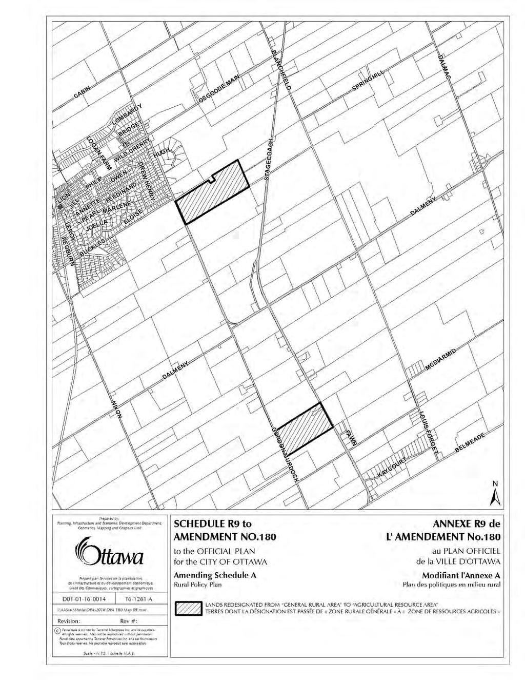
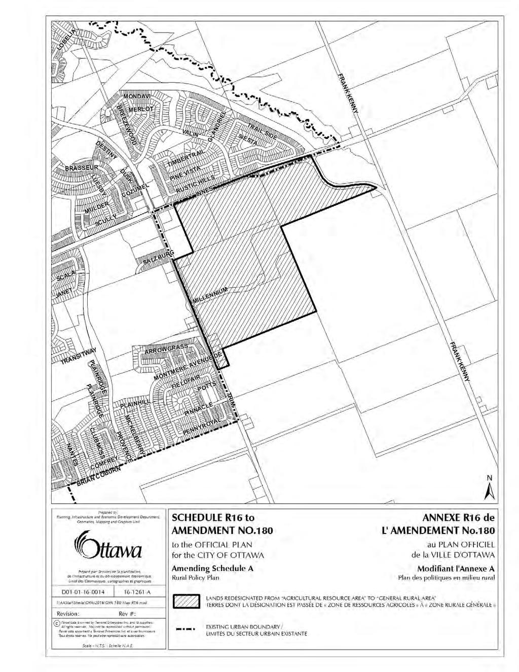
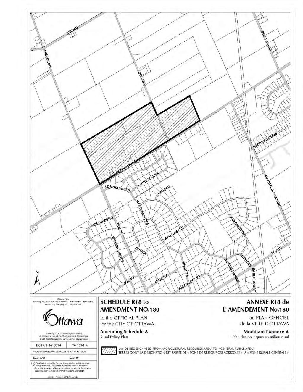
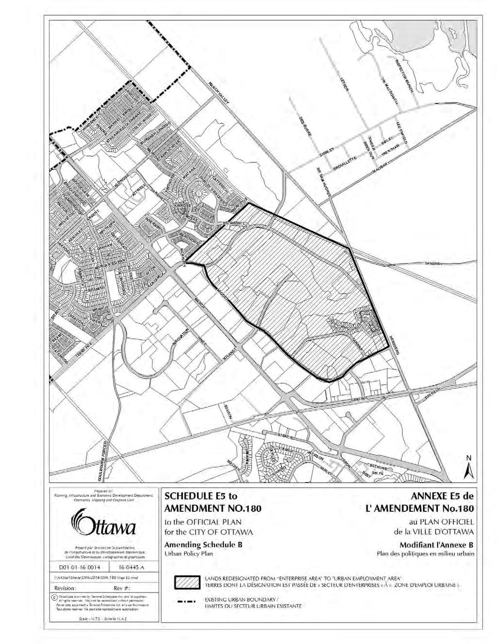
10 m. Schedule R15 changes the designation of land located between Frank Kenny Road and O Toole Road and South of Willhaven Dr, from General Rural Area to Agricultural Resource Area. n. Schedule R16 changes the designation of land located west of Trim Road and south of Innes Road, from to Agricultural Resource Area to General Rural Area. o. Schedule R17- changes the designation of land south of Frank Kenny Road and west of Rockdale Road south of the Village of Vars, from Agricultural Resource Area to General Rural Area. p. Schedule R18 - changes the designation of land north of Mitch Owens Road east of Limebank Road and Downey Roads, from Agricultural Resource Area to General Rural Area. q. Schedule R19 - changes the designation of land bounded by Phelan Road, Prince of Wales Drive and Third Line Road, and located north east of the Village of North Gower, from Agricultural Resource Area to General Rural Area. r. Schedule R20 - changes the designation of land located east of River Road at the intersection with Mitch Owens Road, from Agricultural Resource Area to General Rural Area. s. Schedule R21- changes the designation of land located north of Bleeks Road just east of the Conley Road, from Agricultural Resource Area to General Rural Area. t. Schedule E1 changes the designation of land previously identified as the Carp Road Corridor Rural Employment Area to Rural Employment Area. u. Schedule E2 changes the designation of land fronting Alti Place and land located between Highway 416 and Moodie Drive, north of Fallowfield Road., from Limestone Resource Area and General Rural Area to Rural Employment Area. v. Schedule E3 changes the designation of land located south of Rideau Road and east and west of Hawthorne Road, from General Rural Area to Rural Employment Area. w. Schedule E4 changes the designation of land located south east of the interchange with Highway 417 and Boundary Road from General Rural Area to Rural Employment Area. x. The Legend to Schedule A will be updated to replace the notation Carp Road Corridor Rural Employment Area with the notation Rural Employment Area. 15. The following Schedules amend Schedule B of the Official Plan: a. Schedule E5 changes the designation of land located in the Kanata North Business Park east of Legget Drive and west of the Rail line and Herzberg Road, from Enterprise Area to Urban Employment area. 10
11 b. Schedule E6 - changes the designation of land located; 1. On Didsbury Road, north of Highway 417, from Enterprise Area to Mixed Use Centre; and 2. West of Palladium Drive in Kanata from Enterprise Area to General Urban Area and Urban Employment Area; and 3. South of Maple Grove Road and west of Huntmar Road, from Mixed Use Centre to General Urban Area. As part of this change Schedules S3 and T1 from OPAs#150 and #140 are repealed. c. Schedule E7 changes the designation of land located in the Kanata South Business Park from Enterprise Area to General Urban Area and Urban Employment Area but maintains the Arterial Mainstreet Designation for the land fronting Eagleson Road. d. Schedule E8 changes the designation of land located in Bells Corners north of the Robertson from Enterprise Area to Urban Employment Area but maintains the Arterial Mainstreet along Robertson Road. e. Schedule E10 changes the designation of land located in the Riverside South community from Employment Area to General Urban Area. f. Schedule E11- changes the designation of land located south of Leitrim Road in Leitrim from Employment Area to General Urban Area. g. Schedule E12 changes the designation of land located in the east urban community and which is south of Innes Road, east of Pagé Road. and straddling Mer-Bleue Road, from 1. Employment Area to General Urban Area; and 2. Mixed Use Centre to Urban Employment Area; and 3. Extends the existing Arterial Mainstreet on the south side of Innes Road west to Pagé Road. As part of this change Schedule S23 in OPA #150 is modified and Schedules S63 and T3 in OPAs #150 and #140 are repealed. h. Schedule E13 - changes the designation of land located at 8600 Jeanne d Arc Boulevard North in Orleans, from Enterprise Area to Urban Employment Area. i. The Legend to Schedule B will be updated to remove the notation and colour code for Enterprise Area and to replace the notation Employment Area with the notation Urban Employment Area. 11
12 PART B THE AMENDMENT 1.0 The Introductory Statement All of this part of this document entitled Part B The Amendment, consisting of the following Tables and Schedules, constitutes Amendment No. 180 to the City of Ottawa Official Plan. 2.0 Details of the Amendment The Official Plan for the City of Ottawa is hereby amended as set out in the Table titled Policy Changes - Official Plan Review 2016" and as detailed in the Schedules attached hereto as Schedules R1, R4, R5, R7, R8, R9, R10, R13, R14, R15, R16, R17, R18, R19, R21, E1, E2, E3, E4, E5, E6, E7, E8, E10, E11, E12 and E13. Information about the Table titled Policy Changes - Official Plan Amendment 180": All policy changes or groups of changes are numbered in sequential order in the left column for ease of reference. The second column identifies the existing Official Plan Section to which the change applies. The third column identifies the substance of the change to the policy or policies. Changes include additions of new policies, corrections to existing policies or words, moved policies and deletions or replacements of policies. The fourth column identifies the anticipated new policy numbering that would apply when changes take effect. Unless otherwise stated references to a policy number refer to the existing policy as found in the Official Plan that is in force at the time of adoption of this amendment by the City. Wherever possible, cross-references within policies refer to the new or amended policy numbers. Once the Official Plan Amendment is approved and or modified the numbering, including cross-references, will be further updated to reflect the way they will appear in the final Official Plan document. 12

13 Table Policy Changes Official Plan Amendment 180 Item Section Details of Amendment New Policy No The Role of the Official Plan Amend the new policy added by Item 1a) of OPA #150 by replacing the reference to 2013 at the end with the date 2036 : Building a Sustainable City Patterns of Growth Amend Item 6 of OPA #150 by replacing the date 2031 with date 2036 in the first sentence beginning with the words The Official Plan works in parallel with several supporting plans Amending Item 11 of OPA #150 by: a) Amending the last paragraph of Item 11b) titled Growth in Numbers to replace the date 2031 in the first line with the date 2036 ; and. b) Repealing Item 11c) and replacing it with the following: c) deleting Figure 2.1 and replacing it with the following: c) Amending Item 11e) by replacing the words 30 percent by 2031 compared to 2006 reaching an estimated 1.1 million people in the first sentence of the first paragraph, 13
14 Item Section Details of Amendment New Policy No. with the words 32 per cent by 2036 compared to 2011 reaching an estimated 1.2 million people. and d) Amending Item 11e) by replacing the words 2000 to 2010 period at the end of the second sentence of the first paragraph, with the words 2005 to 2015 period ; and e) Amending Item 11e) by replacing the words 20 per cent by 2031 in the second sentence in the second paragraph with the words 21 percent by 2036 ; and f) Amending Item 11e) by replacing the words 170,000 jobs by 2031 in the first sentence of the fourth paragraph with the words 167,00 jobs by 2036 ; and g) Amending Item 11e) by replacing the words 6 per cent of the new jobs in the last sentence of the fourth paragraph with the words 5 per cent of the new jobs Amend the City s Official Plan to replace Figure 2.2 Projected Growth in Population, Households and Employment, City of Ottawa, 2006 to 2031 with the following new table Figure 2.2 Projected Growth in Population, Households and Employment, City of Ottawa, 2011 to 2036 Population Inside Greenbelt 530, , , ,000 Outside Greenbelt, Urban 300, , , ,000 Rural 91, , , ,000 Total 921,000 1,028,000 1,154,000 1,214,000 Households 14
15 Item Section Details of Amendment New Policy No Inside Greenbelt Outside Greenbelt, Urban 239, , , , , , , ,000 Rural 32,000 35,400 40,500 43,000 Total 380, , , ,000 Employment Inside Greenbelt 455, , , ,000 Outside Greenbelt, Urban 85, , , ,000 Rural 26,500 30,000 33,000 34,500 Total 566, , , ,000 Notes: 1. Totals may not add due to rounding figures are estimated actual; other years are projections 3. Population and households are adjusted for Census undercounting. Population includes institutional residents; households exclude institutional residents employment based on City of Ottawa Employment Survey, adjusted for undercounting Managing Growth Amend the preamble by inserting after the new paragraph added by Item 12 g) of OPA #150 and beginning with the words Lands designated General Urban Area will continue to mature, the following two new paragraphs Urban and Rural Employment Areas are lands reserved for specific land uses that 15
16 Item Section Details of Amendment New Policy No. need strategic locations or separation distances by virtue of their activity from other land uses. Urban and Rural Employment Areas are important to help diversify the local economy that is dominated by government, office and population-related services. The maintenance of an adequate supply of suitable employment land is essential to the future economic prosperity of Ottawa and its residents. Many of the larger and older Urban Employment Areas are inside the Greenbelt, well established, and have good access to highways, rail and/or arterial roads. The combination of these attributes makes these business parks a key component to diversifying the local economy and therefore they should be protected over the long term. However, the small supply of vacant land limits their ability to accommodate future job growth within this sector of the economy. Expansion is difficult for all of these areas due to established adjacent uses. Most of the vacant supply is in locations outside of the Greenbelt where the majority of future Urban Employment Area jobs are expected to locate Amend the preamble by inserting the word and after the last bulleted item in the paragraph added by Item 12 m) of OPA #150 and adding a new bulleted item at the end as follows: Direct rural employment growth that is not appropriate in a village to Rural Employment Areas Managing Intensification within the Urban Area Replacing Item 32 b) of OPA #150 with the following: b) Adding the word Urban before the words Employment Areas and adding the following words identified in Policy 1 Section at the end Replacing Item 33 b) of OPA #150 with the following: b) amending Policy 5 by renumbering this policy and deleting the last sentence and replacing it with the following: 3 The targets are: 40 per cent in ; 42 per cent in ; 44 per cent in ; and 46 per cent in
17 Item Section Details of Amendment New Policy No a) Repeal Items 51 to 60 of OPA #150 in their entirety. Preamb b) Amend the Official Plan by replacing policies 20 to 28 with the following Section le heading, preamble and policies: & 1-9 Section City-wide Employment Area Policies This Plan supports the protection of business and economic activity clusters inside the Greenbelt, within Villages, and at strategic locations close to major goods movement facilities and corridors. These lands often come under pressure from other land uses that also may find it advantageous to locate in areas with these characteristics, increase land values and undermine this Plan s intention to protect and preserve land for employment uses and economic diversity. This Plan manages economic growth and diversity by protecting some lands primarily for employment use so that they remain affordable for employment purposes and so that they can develop over time without conflict from competing land uses. Employment lands inside the Greenbelt are well served by the transportation system providing good access to a diversity of jobs. This supports the concept of complete communities, where residents have opportunities to live closer to their work. Employment lands inside the Greenbelt and those that are in close proximity to highway interchanges, freight railways and/or arterial roads are strategic locations for employment uses. To support efficient workforce access to employment locations, Major Office development is directed to adjacent transit infrastructure. Policies 1. Employment Areas corresponding to clusters of business and economic activities in the Provincial Policy Statement include: Urban Employment Areas designated on Schedule B of this Plan, Prestige Business Parks and Business Parks designated in Secondary Plans, Industrial Areas designated in Village Plans, and Rural Employment Areas designated on Schedule A of this Plan. Notwithstanding Schedule B of this Plan where lands are designated Prestige Business Park or Business Park in a Secondary Plan the Urban Employment Area designation shall correspond to the more detailed land use schedule in the Secondary Plan. Employment uses are those described in Sections and of this Plan and the respective sections in the Secondary Plans and 17
18 Item Section Details of Amendment New Policy No. Village Plans relating to employment areas. 2. In all urban communities outside the Central Area, areas will be planned for a range of employment opportunities. Urban Employment Areas within each of the five urban communities outside of the outer edge of the Greenbelt, as shown in Figure 2.1, will be designated to ensure an ongoing supply of vacant Urban Employment Lands. The amount of employment land to be maintained in each community shall be determined at the time of a comprehensive review. 3. The City will also encourage employment in the Villages of Greely, Manotick, and Richmond and a ratio of at least 0.65 jobs per household will be reflected in the amount of land designated for employment and residential development in each of these villages. 4. While it is the City s preference to locate most employment uses in the Urban Area and Villages, agriculture, aggregate resources and other agriculture related industries will support employment throughout the Rural Area. Employment uses that are not appropriate in a Village due to their impacts, and which do not require municipal services, are encouraged to locate in designated Rural Employment Areas. 5. The City encourages intensification and renewal of employment uses within the Urban Employment Areas located inside the Greenbelt. Because of their central location these Employment Areas provide access to goods movement corridors and major transportation routes for workforce access. These locations also create stable operating environments for a wide variety of traditional industrial uses, which helps to diversify the local economy. 6. Major Office Development, consisting of buildings over 10,000 m2 gross leasable area, will play a fundamental role in supporting and increasing the ridership of the Rapid Transit and Transit Priority Network and shall be located in areas adjacent to the Rapid Transit and Transit Priority Network. Except where currently permitted by zoning, the City will only permit new Major Office Development in the following locations: a. Central Area; b. Mixed Use Centres; 18
19 Item Section Details of Amendment New Policy No. c. Town Centres; d. On land fronting Traditional Mainstreets or Arterial Mainstreets that are Transit Priority corridors or where the development is within 800 metres walking distance of an existing or planned Rapid Transit station; e. Urban Employment Areas where the majority of the site is within 800 metres walking distance of an existing or planned Rapid Transit station or 400 metres walking distance of a Transit Priority corridor. f. Kanata North and Kanata South Urban Employment Areas once a secondary plan for the Area or Areas has been adopted and identifies the preferred location for Major Office Uses. g. General Urban Areas where: i. The majority of the site is within 800 metres walking distance of a Rapid Transit station or 400 metres walking distance of a Transit Priority Corridor on Schedule D; and ii. The site is on an Arterial Road on Schedules E or F; and iii. The immediate area is characterized by existing or planned commercial development; and iv. The Design Objectives in Section and the Urban Design and Compatible Development policies in Section 4.11 can be satisfied. 7. The City plans, protects and preserves lands for current and future employment uses through a comprehensive review process and therefore discourages the removal of employment lands for other purposes on an individual basis. 8. A comprehensive review to assess requests to convert employment lands to other purposes will consider such matters as: a. Whether the employment lands being proposed for conversion are unsuited for employment purposes and whether there are practical means to make them suitable; b. Whether the lands are suitable for the uses being proposed and whether there is a need for those uses; c. The current supply of developable land within the urban boundary, its 19
20 Item Section Details of Amendment New Policy No. distribution within the city, and its potential to be developed for housing, employment, and other purposes; d. The distribution of employment land throughout the city; e. The ability to provide sufficient opportunities for the clustering of areas of like employment; f. The sufficiency of the supply of optimum-sized employment land parcels for the range of employment uses anticipated by this Plan; g. The preservation of lands for employment uses in areas proximate to 400 series highway interchanges or with accessibility to rail and airports, is intended to maintain opportunities that recognize the potential for the development of transport and freight handling uses; h. The preservation of lands for employment uses proximate to essential linkages, such as supply chains, service providers, markets, necessary labour pools, etc.; i. The preservation of a diversity of Urban and Rural Employment Areas for a variety of employment uses (e.g. light and heavy industrial, business park, research campus, etc.); j. The demand that proposed non-employment use(s) will create for additional municipal amenities and services in addition to those required by employment uses and the cost of providing same, including any mitigation deemed necessary to address any negative effects on employment uses in matters such as those listed in k below; k. The impact the proposed use(s) would have on the viability of any remaining employment lands or existing employment uses with regard to matters such as: i. Incompatibility of land use, ii. The ability to provide appropriate buffering of employment uses from surrounding non-employment uses on and off-site, iii. Affordability (e.g. land and lease costs) for employment purposes, iv. Market acceptance/competitiveness (attractiveness of the employment lands in the marketplace for continued development for employment uses), v. Removal of key locations for employment uses, vi. Reduction or elimination of visibility of employment lands or uses, vii. Reduction in optimum size (of either individual employment land 20
21 Item Section Details of Amendment New Policy No. parcels or the overall Urban or Rural Employment Area), viii. Interference with the function of the employment lands (e.g. restricting operating hours or delivery times or affecting the capacity of the transportation network due to characteristics of the employment uses such as noise or emissions or heavy equipment operation), ix. Accessibility to the employment lands, x. Ability to provide for a variety of employment options, parcels, and xi. Maintenance of the identity of the employment uses or area. 9. Policy 8 above does not apply to those Urban Employment Areas with a site specific exception to permit residential uses as listed in Section of this Plan Transportation General Urban Area Amend Item 62 sub-item e) of OPA #150 by replacing the third paragraph beginning with the words The share of travel by sustainable modes with the following: The share of travel by sustainable modes - walking, cycling, transit and automobile passenger - is targeted to reach 50 per cent of the total trips in the city by This is an increase from the 2011 level of 45 per cent. This shift in modal split is anticipated to continue to increase over the period of this Plan. Achieving this target means a substantial increase in travel by transit, since transit will be providing a larger share of all trips as the population grows. Despite this shift towards walking, cycling and transit, expansion of the road network will be necessary, particularly to provide new or improved road access to suburban communities beyond the Greenbelt. The need for new roads and ongoing improvements to the road infrastructure network is identified in the Transportation Master Plan. Add the following new Site Specific Exception policy at the end of Section 3.6.1: 15. A district park of 11.1 gross hectares shall be provided southwest of the Highway 417 and Palladium Drive interchange. Preamb le 15 21
22 Item Section Details of Amendment New Policy No a) Repeal Items of OPA #150 in their entirety; and Preamb Employment b) Repeal Items g. and h. of OPA #140 in their entirety: and le & Area and c) Amend the Official Plan to rename Section and replace the preamble and policies 1-15 Enterprise Area with the following: Urban Employment Area Employment-related land uses are permitted in almost every urban designation in the Official Plan. The Central Area is the foremost employment concentration and will continue that role. Most business activities can integrate well with other land uses and it is the intent that these be focused on nodes and corridors (Mixed Use Centres and Mainstreets). All three of these designations anticipate a healthy mix of business, retail, housing, institutional and cultural uses. However, one of the key objectives of this Official Plan is to ensure that, over the long term, sufficient areas of land are reserved primarily for places of business and economic activity. Uses that support this function consist predominantly of offices, manufacturing, warehousing, distribution, research and development facilities and utilities. Maintaining a sufficient supply of land for this range of activities is key to the long-term economic health of the community and its ability to attract and retain new investment. Typically, Urban Employment Areas provide large parcel sizes, reflective of user needs for storage, parking and building floorplate, and they are usually well situated with respect to major roads. To help provide access to these jobs Urban Employment Areas should be centrally located or close to highways and/or transit depending on the focus of the business park. Urban Employment Areas outside of the Greenbelt at highway interchanges are strategically located for a range of Urban Employment uses, particularly those that have a regional draw and rely on major goods movement corridors for their function. Urban Employment Areas not located in proximity to highway interchanges are expected to provide Employment uses that serve the local population or create synergies with local institutions such as the Macdonald-Cartier International Airport, RCMP headquarters, or high-tech clusters. Urban Employment Areas are designated to enable a variety of functions: Noxious industrial uses that impose constraints on other uses locating nearby 22
23 Item Section Details of Amendment New Policy No. and require a buffer between these and other uses; Uses that, while not noxious, are incompatible with other uses because of noise, lights and around the clock operation, etc.; Prestigious uses (usually office or combinations of office/clean industrial) with a signature address and a desire to locate among other similar uses. The decision to designate land as an Urban Employment Area on Schedule B of this Plan will be determined, in part, by its ability to accommodate at least 2,000 jobs. The attractiveness for uses in Employment Areas will vary based upon location attributes such as key locations on 400 series highways and multi-lane arterials, and locations that have good truck, rail or air access. These are also areas that can provide large parcels of land at affordable prices. Lands designated as Urban Employment Areas on Schedule B of this Plan are distributed throughout the urban fabric, with at least one in each urban community outside the Greenbelt boundary. Policies addressing the creation and conversion of employment land and the creation of major office developments are contained in Section of this Plan. Uses that require large land areas for the external storage of goods or for vehicle sales and service may be carried out in Urban Employment Areas. Incidental activity carried out in combination with a main use, such as showroom space associated with warehousing and storage, is also anticipated in Urban Employment Areas. Complementary uses, such as service commercial, are appropriate in Urban Employment Area designations to meet the day-to-day needs of employees and reduce their need to travel outside the area. Policies 1. Urban Employment Areas are designated on Schedule B and are intended to be established clusters of business and economic activity capable of accommodating more than 2,000 jobs and with a board spectrum of job densities. Urban Employment Areas shall be distributed throughout the urban area to help provide access to jobs throughout the city. Established Urban Employment Areas have capacities ranging from 2,000 to 20,000+ jobs. The City shall maintain sufficient land in these Employment Areas to maintain the Employment objectives established in the City Employment Survey. New Urban Employment Areas shall have sufficient land to accommodate a minimum of 23
24 Item Section Details of Amendment New Policy No. 2,000 jobs based upon a diversified cluster of business types and economic activity and employment densities. These New Employment areas must also be located so that they have designated truck route access. Some Urban Employment Areas may not be contiguous as a result of natural or human-made barriers, or existing land uses. 2. In Urban Employment Areas, the Zoning By-law will: a. Permit traditional industrial uses such as manufacturing, warehousing, distribution, storage, communications, construction; b. Permit uses that store most products outdoors and require large land areas devoted to external storage, sale or service of goods or for vehicle sales and service; c. Permit office uses and similar uses at similar densities, including, research & development and emergency services. Universities, community colleges and private career colleges will be established by an amendment to the Zoning By-law and are subject to Major Urban Facilities Policies 5 to 10 in Section d. Permit sample and showroom uses, meaning that portion of a building operating only in association with a warehouse or other permitted use in the same building, primarily used for the display of samples, patterns or other goods and wherein orders are taken for merchandise which is stored in bulk in a warehouse in part of the same building for future delivery to its customers, and where the proportion of the gross leasable area of a building devoted to sample and showroom use is limited in the Zoning By-law so that sample and showroom space is secondary and subordinate to the primary use of the building for warehouse storage; e. Permit a variety of ancillary uses, such as recreational, health and fitness uses, child care, and service commercial uses (e.g. convenience store, doctor and dentist office, shoe repair shop, coffee shop, restaurant, bank, dry-cleaning outlet, service station or gas bar) consisting of small occupancies on individual pads, within a building containing a permitted use, in groups as part of a small plaza, or on small lots. The purpose of these complementary-type uses is to serve the employees of Urban Employment 24
25 Item Section Details of Amendment New Policy No. Areas. Ancillary uses are to be clearly incidental to the primary employmentgenerating uses listed in subsections a, b and c above, and will not be of a size or nature that draw clientele from a beyond the local area. Ancillary uses consisting of a single occupancy on an individual pad shall be limited to 750 m 2 of gross floor area. Alternative and area specific limitations may be determined through a municipally-initiated Zoning By-law Amendment that analyses the appropriate size and application of ancillary uses relative to the circumstances and attributes of the different Urban Employment Areas to their surrounding community. The Zoning By-law shall establish an individual occupancy and a cumulative total gross floor area limit for ancillary uses. Amendments to either the individual or cumulative limits above shall assess whether the use with the proposed floor space is ancillary to the subject Urban Employment Area; f. Consider through a site specific amendment to the Zoning By-law permitting low density institutional uses such as community centres, daycares, places of worship only if the proposed use is compatible with existing and potential permitted uses as specified in the Zoning By-law; and, the ability for the remainder of the Urban Employment Area to achieve the requirements of Policy 1 above or as otherwise provided for in a Secondary Plan. The compatibility assessment will be guided by the Ministry of the Environment D Series Guidelines, as amended. The identification of potential permitted uses may consider the impact that existing uses adjacent to and within the Urban Employment Area may already have on a non-existing use that is permitted in the Zoning By-law. g. Distinguish uses with characteristics that are likely to impact negatively on surrounding areas (e.g., industrial uses that produce odours, dust, smoke, heavy equipment movement, large areas of outdoor storage, or noise) from those uses that are likely to have negligible such impacts (e.g., offices or research and development facilities); h. Not permit industrial uses or development with the potential of restricting visibility at the Ottawa Macdonald-Cartier International Airport, the Rockcliffe Airport or the Carp Airport by virtue of industrial/manufacturing processes generating smoke, dust, or steam as described in Transport Canada s Land 25
26 Item Section Details of Amendment New Policy No. Use in the Vicinity of Airports document TP1247E; 3. The City will discourage the removal of employment lands for other uses as set out in Section of this Plan. Site-Specific Exceptions 4. Notwithstanding any provisions of this Plan that establish minimum land requirements for an Urban Employment Area, the Iber Road Urban Employment Area shall have sufficient land to establish a cluster of business and economic activity consisting of at least 1,000 jobs at a range of densities. 5. Notwithstanding any provisions of this Plan that prohibit retail uses on lands designated Urban Employment Area, permit retail uses on lands located south of Highway 417, west of Terry Fox Drive, east of the Carp River and north of Palladium Drive, save and except for property with any frontage on Palladium Drive, and provided that adequate road capacity is available; 6. Notwithstanding any provisions of this Plan that prohibit institutional uses on lands designated Urban Employment Area, an institutional use will be permitted on the south half of Lot 26, Concession A, in the former City of Nepean, shown as Part 5 on Plan 5R-8254; 7. In addition to the provisions of the policies set out in this section, Section of the Secondary Plan for Area 1, 2, and 3 in the former City of Nepean set out in Volume 2A of this Plan will apply to the lands described as Parts Lot 19, Concession A, R.F., Nepean: PIN and located east of Merivale Road and west of Prince of Wales Drive in the South Merivale Business Park. 8. Notwithstanding any provisions of this Plan that prohibit retail uses on lands designated Urban Employment Area, the lands identified as Commercial on Schedule A in the Secondary Plan for South Nepean Urban Areas 9 and 10 in the Former City of Nepean as set out in Volume 2A in this Plan may be developed with retail uses, which may also include commercial office use and commercial uses that support the employment use, with a maximum lot area of 12 hectares (30 acres). 9. Notwithstanding any provisions of this Plan that prohibit residential uses on 26
27 Item Section Details of Amendment New Policy No. lands designated Urban Employment Area, the lands bounded by Legget Drive on the west and south, Herzberg Road and the rail line on the east, and the properties fronting onto the north side of Terry Fox Drive on the north, in addition to the permitted uses in Policy 2 above, residential uses may be permitted by an amendment to the Zoning By-law, provided the following criteria are met: a. At least 50 per cent of the lands identified above will be devoted to employment uses; b. A Secondary planning process has been prepared to the City s satisfaction and includes the items identified in Policy 5 of Section of the Official Plan c. The proposed housing is in the form of townhouses, stacked townhouses or apartments. d. Residential uses are linked to adjacent areas by roads and pathways; e. Any demand that residential uses will create for additional amenities and services has been assessed and the means of addressing such demands has been identified; f. The applicable policies in Section 4 have been satisfied; g. The amelioration of potential adverse impacts from adjacent non-residential lighting, noise, odour, dust or traffic can be achieved on-site as part of the development. 10. Notwithstanding any provisions of this Plan that prohibit residential uses on lands designated Urban Employment Area, the lands identified by Parcel identification Number ; and, the community commonly known as Bellwood Estates identified by Parcel Identification Numbers and , in addition to the permitted uses in Policy 2 above, residential uses may be permitted by an amendment to the Zoning By-law, provided the following criteria are met: a. A Secondary planning process has been prepared to the City s satisfaction and includes the items identified in Policy 5 of Section of the Official Plan 27
28 Item Section Details of Amendment New Policy No. b. The proposed housing is in the form of townhouses, stacked townhouses or apartments. c. Residential uses are linked to adjacent areas by roads and pathways; d. Any demand that residential uses will create for additional amenities and services has been assessed and the means of addressing such demands has been identified; e. The applicable policies in Section 4 have been satisfied; f. The amelioration of potential adverse impacts from adjacent non-residential lighting, noise, odour, dust or traffic can be achieved on-site as part of the development. 11. The eastern boundary of the Urban Employment Area at Leitrim Road and Albion Road will be defined by the realignment of Leitrim Road as identified by an approved Environmental Assessment. Notwithstanding Policy 8 in Section of this Plan lands east of the Leitrim Road realignment have been assessed through a comprehensive review and will not require a further conversion analysis. Applications for the development of the land east of the Leitrim Road realignment will not be considered until an Environmental Assessment has determined the final location of the realigned road. The Environmental Assessment shall consider an alignment that is viable for Employment uses on vacant lands immediately west of the proposed alignment. 12. Employment uses within 400 metres of the planned rapid transit station at Mer Bleue Road in the South Orléans Urban Employment Area shall have a minimum density of 200 jobs per hectare. The minimum density may be reviewed and if necessary amended by a secondary planning process. 13. Notwithstanding any provisions of this Plan that prohibit residential uses on lands designated Urban Employment Area, for the lands known as 8600 Jeanne d Arc Boulevard North, residential development in the form of townhouses, stacked townhouses or apartments will only be permitted after 10,000 square metres of office floor space has been constructed. Residential uses may occupy greater than 50 per cent of the total site where the additional units are included in one or more mixed-used buildings. Any building containing residential uses 28
29 Item Section Details of Amendment New Policy No. shall be limited in height to a maximum of 10 storeys. 14. A minimum of 21.9 gross hectares of developable Urban Employment Area land is to be provided southwest of the Highway 417 and Palladium Drive interchange. For the purposes of this policy lands containing a park or stormwater management ponds shall not be considered as developable lands for employment uses. 15. Notwithstanding any provisions of this Plan that prohibit a Retirement Home and Residential Care Facility on lands designated as Urban Employment Area, a Retirement Home and Residential Care Facility may be permitted on the lands identified by Parcel Identification Number General Rural Area Amend Item 188 Of OPA #150 by replacing sub-item a) by the following sub items and renumbering accordingly. a) Deleting the words or by country lot subdivision as provided for in policy 7 below. At the end of the first sentence: b) Deleting paragraphs a. and b. and inserting the following new text and renumbering as required: a. Agriculture-related industrial and commercial uses, such as farm equipment and supply centres, farm equipment repair shops, and nurseries. c) Deleting paragraph e. and replacing it with the following new text: e. Other new non-residential uses that would not be better located within a Village or Rural Employment Area and which are in keeping with the rural character or those uses that meet the needs of the travelling public, such as a restaurant; gas station; motel; retail not exceeding 300 square metres of cumulative total gross leasable floor area on a lot; or, similar use. This policy does not apply to lands where the Zoning By-law on the date of adoption of this Plan permits a total gross leasable floor area greater than 300 square metres. a - e 29
30 Item Section Details of Amendment New Policy No a) Repeal Item 189 of OPA #150 6 b) Amend Policy 6 by: i) Adding the words Rural Employment Area after the word village, in paragraph a. ii) Adding the word uses following the words nearby rural residential in paragraph d. iii) Deleting paragraph g. and renumbering as needed Add a new Site Specific policy at the end of Section as follows: Agricultural Resources 23. Notwithstanding Policy 5a, for the lands designated General Rural Area around the interchange at Highway 417 and Rockdale Road, a Zoning By-law amendment will be required where a new industrial and commercial use, such as farm equipment and supply centres, machine and truck repair shops, building products yards, landscape contractors and nurseries are proposed. a) Repeal Item 200 of OPA #150: and b) Replace the first three paragraphs of the Preamble to Section and replace them with the following: Farm land is an important land use in Ottawa, occupying about 40 per cent of the municipality s rural lands. Located on these extensive areas of good soil totaling more than 120,000 hectares is a mixture of cash crop and livestock farms producing agricultural products with a value in 2011 of over $200 million. The approximately 1,125 farm holdings in Ottawa also create economic activity for related businesses, such as agricultural supplies, equipment stores and processing plants for farm products. The number of farms producing food products and value added products for the local market is increasing. In order to protect this resource for future generations, the City will protect prime agricultural areas from loss of lands to other uses. This protection entails policies that strictly limit permitted land uses and lot creation on all lands identified as Agricultural Resource Areas. Their identification is based on the Ottawa Land Evaluation and Area Review (LEAR) evaluation system. Agricultural lands are also identified in the National Capital Greenbelt Plan produced by the Preamb le 30
31 Item Section Details of Amendment New Policy No. National Capital Commission Amend Policy 1, by deleting the words with the intent of and adding a new sentence before the following paragraphs a. and b. as follows: The purpose of this designation is to: Delete Policy 2 and replace it with the following three new policies and renumbering: 2. Within the Agricultural Resource Areas designation all types, sizes and intensities of agricultural uses and normal farm practices shall be permitted. Agricultural uses should respect the provincial Guide to Agricultural Land Use, and applicable provincial regulations governing farm operations. 3. On-farm diversified uses and agriculture-related uses subject to the criteria below and the Provincial Guidelines are also permitted. a. On-farm diversified uses are secondary to the principle agricultural use of the property. They are to be limited in area and include but are not limited to; home-based businesses, home industries, agri-tourism and uses that produce value-added agricultural products from the farm operation. b. Agriculture-related uses are those small-scale commercial and industrial uses that are intended serve and are compatible with local farm operations and do not hinder surrounding agricultural operations. Applicants for new agriculture-related uses require a zoning amendment and the applicant must demonstrate that the use needs to be located in the Agricultural Resource Area and that every effort has been made to locate the use in an area of poorer soils. 4. Uses such as forestry and those activities related to the conservation or management of the natural environment are also permitted
32 Item Section Details of Amendment New Policy No Amend policy 3, by deleting the third sentence and replacing it with the following: 5 It may be located on the same lot as the farmhouse and should preferably take the form of a mobile home, as defined in the zoning by-law, so that it can be removed once the farm help is no longer required a) Repeal Item 201 of Official Plan Amendment #150 b) Delete the existing sub heading Secondary Uses and policies 4 and 5 in Section in their entirety Add the following two new policies at the end of the Section under the sub-heading Site Specific Policies 19. Notwithstanding the provisions of this Section, the lands identified by Parcel Identification Numbers and in the vicinity of Thomas A. Dolan Parkway and John Shaw Road may be severed, subject to meeting the following conditions: a. the minimum lot size for the severed and retained parcels is 0.8 ha; b. the applicant demonstrates that both the severed and retained lots can be serviced; 20. Notwithstanding the policies in this section that limit lot creation, the severance of one lot is permitted on the lands located at 4109 Viewbank Road, Property Identification Number , on the condition that the severed and retained lots comply with the MDS 1 setback requirements and have a minimum lot area of 0.8 ha Carp Road Corridor Rural Employment Area Amend Section by: a) Deleting the words Carp Road Corridor from the title of the section so that it reads Rural Employment Area
33 Item Section Details of Amendment New Policy No. b) Deleting the preamble and policies and replace them with the following: This Plan anticipates that 5% of the city s employment will be located in the rural area. The majority of non-farm employment will be encouraged to locate in villages and in Rural Employment areas. Rural Employment Areas are intended to support and encourage clustering of primarily industrial uses not suitable in the Urban Area or General Rural Area. The existing rural employment areas provide for a full range of industry sectors, which includes, but is not limited to, manufacturing, mining (aggregates), construction, agriculture, transportation as well as other professional and business services and ancillary retail. Rural Employment Areas add to the diversity of opportunities for economic development and those seeking large sites and proximity to the urban area. Those rural employment areas located in close proximity to 400 Series Highway interchanges are uniquely suited to transportation facilities such as truck terminals, warehouses, courier and freight facilities that support inter and intraprovincial movement of goods. Policies 1. The Rural Employment Areas are designated on Schedule A with the intent to reserve the land for rural industrial and ancillary commercial uses. 2. Uses permitted within rural employment areas include: a) New heavy and light industrial uses, such as steel and concrete fabrication, farm equipment and supply centres, machine and vehicle sales service and repair, construction yards, building products yards, landscape contractors, nurseries; b) New transportation, warehouse and storage operations; these uses are encouraged to locate on sites in close proximity to Arterial roads and Highway interchanges; c) Uses that are noxious by virtue of their noise, odour, dust or other emissions or that have potential for impact on air quality or surface water or groundwater, such as salvage or recycling yards, composting or transfer facilities; concrete plants; the treatment of aggregate products; and 33
34 Item Section Details of Amendment New Policy No. abattoirs; these uses shall not be located adjacent to a highway unless suitable screening and landscaping are provided ; d) New commercial uses that primarily provide services to employees of the rural business park or the travelling public such as a restaurant, gas station, a retail store up to 300 square metres gross leasable space, or similar uses. A commercial use involving the display and sale of products manufactured or warehoused on the site are permitted provided that the retail floor space does not exceed the greater of, 300 square metres or 25% of the gross floor area of the building. 3. Development will be subject to Site Plan Control and particular attention will be given to the physical design of the building and site including signage, buffering, landscaping and fencing. In particular the City shall require that suitable screening and landscaping is provided for any new external storage areas for goods, material and equipment that abut a highway or arterial road. All new development must be supportable on individual well and septic systems unless the City agrees to the development of a number of sites on the basis of a small water and wastewater works as described in Section Carp Road Corridor Rural Employment Area The Carp Road Corridor Rural Employment Area plays an important role in the development and well-being of the local economy. The diversity and the ability to attract a range of traditional and high technology industries as well as environmental services, some value-added processing, wood and metal fabrication and commercial uses has been one of the strengths of the Corridor. The vision for this area is contained in the Carp Road Corridor Community Design Plan. In order to remain successful in the future, this area must maintain the ability to allow for a diverse range of uses while developing an appealing environment for those new industries willing to expand within or relocate to the corridor. Policies 1. New development applications will conform to the policies in the approved 34
35 Item Section Details of Amendment New Policy No. community design plan Urban Expansion Study Area 2. The community design plan for the Carp Road Corridor shall provide direction to the Zoning By-law for future land uses. Amend the preamble to Section 3.11 by inserting the word urban between the words projected and population in the first sentence and deleting the words to 2031 at the end of the first sentence. Preamb le Developing Community (Expansion Area) 25. Schedule A - Rural Policy Plan Amend Policy 1 by inserting the word urban between the words projected and population in the first sentence and deleting the words to 2031 at the end of the first sentence. Amend Schedule A to change the designation of land south-west of Stonecrest Road, Fitzroy from General Rural Area to Agricultural Resource Area as shown on Schedule R1 to this amendment Amend Schedule A to change the designation of land west of the Highway 417 inter-change at Panmure Road from General Rural Area to Agricultural Resource Area as shown on Schedule R4 to this amendment. 27. Amend Schedule A to change the designation of land Located east of Golden Line Road north of McArton Road to Old Almonte Road. from General Rural Area to Agricultural Resource Area as shown on Schedule R5 to this amendment. 28. Amend Schedule A to change the designation of land in two locations South of Fallowfield Road either side of Dwyer Hill Road and between Munster and Conley Roads, from General Rural Area and Rural Natural Features to Agricultural Resource Area as shown on Schedule R6 to this amendment. 29. Amend Schedule A to change the designation of land east of Keatley Road and West of the Rail Corridor, south of Arnprior, from Agricultural Resource Area to General Rural Area as shown on Schedule R7 to this amendment. 35
36 Item Section Details of Amendment New Policy No. 30. Amend Schedule A to change changes the designation of three parcels of land located : 1. North-east of the intersection of Greenbank Road and Barnsdale Road; 2. South-east of the urban boundary near Stromness Street; and 3. In the triangle enclosed by Prince of Wales Drive, Barnsdale Road and Rideau Valley Drive; from Agricultural Resource Area to General Rural Area as shown on Schedule R8 to this amendment Amend Schedule A to change the designation of land in two locations; 1. South of the Village of Osgoode; and 2. Land running between Gordon Murdock Road and Stagecoach Road near the City s southern Boundary; from General Rural Area to Agricultural Resource Area as shown on Schedule R9 to this amendment. Amend Schedule A to change the designation of land west of the Village of Metcalfe and fronting Bank Street, from Agricultural Resource Area to General Rural Area as shown on Schedule R10 to this amendment. 33. Amend Schedule A to change the designation of land located: 1. South of Devine Road and the Village of Vars from General Rural Area and Rural Natural Features to Agricultural Resource Area; 2. North of Devine Road and east and west of Sand Road from Rural Natural Features to Agricultural Resource Area; and 3. land fronting the east side of Frontier Road north of Devine Road; from General Rural to Agricultural Resource Area as shown on Schedule R11 to this amendment. 36
37 Item Section Details of Amendment New Policy No. 34. Amend Schedule A to change the designation of three areas of land north of Russell Road and east and west of Rockdale Road, from Agricultural Resource Area to General Rural Area as shown on Schedule R12 to this amendment Amend Schedule A to change the designation of various parcels of land located: 1. North of Russell Road and fronting Sarsfield Road and Russellett Road, from General Rural Area and Rural Natural Features to Agricultural Resource Area; 2. North of Devine Road and east and west of Clayton Road and east of Birchgrove Road; from General Rural Area the Agricultural Resource Area as shown on Schedule R13 to this amendment. Amend Schedule A to change the designation of land located to the south of the intersection of Fallowfield Road and Moodie Drive, from Agricultural Resource Area to General Rural Area and Rural Employment Area as shown on Schedule R14 to this amendment. Amend Schedule A to change the designation of land located between Frank Kenny Road and O Toole Road and South of Willhaven Drive, from General Rural Area to Agricultural Resource Area as shown on Schedule R15 to this amendment. Amend Schedule A to change the designation of land located east of Trim Road and south of Innes Road, from to Agricultural Resource Area to General Rural Area as shown on Schedule R16 to this amendment. Amend Schedule A to change the designation of land south of Frank Kenny and west of Rockdale Road south of the Village of Vars, from Agricultural Resource Area to General Rural Area as shown on Schedule R17 to this amendment. 37
38 Item Section Details of Amendment New Policy No. 40. Amend Schedule A to change the designation of land north of Mitch Owens Road, east of Limebank Road and Downey roads, from Agricultural Resource Area to General Rural Area as shown on Schedule R18 to this amendment. 41. Amend Schedule A to change the designation of land bounded by Phelan Road, Prince of Wales Drive and Third Line Road, and located north east of the Village of North Gower, from Agricultural Resource Area to General Rural Area as shown on Schedule R19 to this amendment Amend Schedule A to change the designation of land located east of River Road at the intersection with Mitch Owens Road, from Agricultural Resource Area to General Rural Area as shown on Schedule R20 to this amendment. Amend Schedule A to change the designation of land located north of Bleeks Road just east of the Conley Road, from Agricultural Resource Area to General Rural Area as shown on Schedule R21 to this amendment. 44. Amend Schedule A to change the designation of land previously identified as the Carp Road Corridor Rural Employment Area, Sand and Gravel Resource Area and General Rural Area to Rural Employment Area and change land from Carp Road Corridor Rural Employment Area to General Rural Area, as shown on Schedule E1 to this amendment. 45. Amend Schedule A to change the designation of land fronting Alti Place and land located between Highway 416 and Moodie Drive, north of Fallowfield Road, from Limestone Resource Area and General Rural Area to Rural Employment Area as shown on Schedule E2 to this amendment. 46. Amend Schedule A to change the designation of land located south of Rideau Road and east and west of Hawthorne Road, from General Rural Area to Rural Employment Area as shown on Schedule E3 to this amendment. 38
39 Item Section Details of Amendment New Policy No. 47. Amend Schedule A to change the designation of land located south east of the interchange with Highway 417 and Boundary Road from General Rural Area to Rural Employment Area as shown on Schedule E4 to this amendment. 48. Amend the Legend to Schedule A to replace the notation Carp Road Corridor Rural Employment Area with the notation Rural Employment Area. 49. Schedule B - Urban Policy Plan 50. Amend Schedule B to change the designation of land located in the Kanata North Business Park east of Legget Drive and west of the Rail line and Herzberg Road, from Enterprise Area to Urban Employment area as shown on Schedule E5 to this amendment. a) Repeal Item 303 (Schedule S3) of OPA #150 in its entirety; and b) Repeal Item q. (Schedule T1) of OPA #140 in its entirety; and c) Amend Schedule B to change the designations of land located; 1. On Didsbury Road, north of Highway 417, from Enterprise Area to Mixed Use Centre; and 2. West of Palladium Drive in Kanata from Enterprise Area to General Urban Area and Urban Employment Area; and 3. South of Maple Grove Road and west of Huntmar Road, from Mixed Use Centre to General Urban Area; as shown on Schedule E6 to this amendment. 51. Amend Schedule B to change the designation of land located in the Kanata South Business Park from Enterprise Area to General Urban Area and Urban Employment Area as shown on Schedule E7 to this amendment, but maintains the Arterial Mainstreet Designation for the land fronting Eagleson Road. 52. Amend Schedule B to change the designation of land located in Bells Corners north of the Robertson Road from Enterprise Area to Urban Employment Area as shown on Schedule E8 to this amendment, but maintains the Arterial Mainstreet along Robertson Road. 39
40 Item Section Details of Amendment New Policy No. 53. Amend Schedule B to change the designation of land located in the Riverside South Community, from Employment Area to General Urban Area as shown on Schedule E10 to this amendment. 54. Amend Schedule B to change the designation of land located south of Leitrim Road east of Albion Road, in Leitrim, from Employment Area to General Urban Area as shown on Schedule E11 to this amendment. 55. a) Amend Item 318 (Schedule S23) in OPA #150 to repeal the designation changes save and except the re-designation of the land south of Brian Coburn Boulevard and east of Mer Bleue Road from Mixed use Centre to General Urban Area; and b) Repeal Item 325 (Schedule S63) in OPA #150 in its entirety; and c) Repeal Item r. of OPA #140 (Schedule T3) in its entirety; and d) Amend Schedule B to change the designation of land located in the east urban community and south of Innes Road, east of Page Road and straddling Mer-Bleue Road., from: 1. Employment Area to General Urban Area; and 2. Mixed Use Centre to Urban Employment Area; and 3. Extending the existing Arterial Mainstreet on the south side of Innes Road west to Page Road; as shown on Schedule E12 to this amendment. 56. Amend Schedule B to change the designation of land located at 8600 Jeanne d Arc Boulevard North in Orleans, from Enterprise Area to Urban Employment Area as shown on Schedule E13 to this amendment. 57. Amend the Legend to Schedule B to remove the notation and colour code for Enterprise Area and to replace the notation Employment Area with the notation Urban Employment Area. 58. Housekeeping Changes The Official Plan of the City of Ottawa is further amended by: a. Placing all sections and policies subject to this amendment in proper numeric and alphabetical order; and b. By correcting all cross references affected by this amendment and the aforesaid reordering. 40
41 PART C IMPLEMENTATION AND INTERPRETATION Implementation The implementation of this Amendment to the Official Plan shall be in accordance with the policies of the Official Plan of the City of Ottawa as amended. 41
42 42
43 43
44 44

45 45

46 46

47 47
48 48

49 49
50 50
51 51
52 52

53 53
54 54
55 55
56 56
57 57
58 58

59 59
60 60

61 61

62 62
63 63
64 64
65 65

66 66

67 67

68 68
69 69
70 70
71 71

72 72

73 73
and services The protection and conservation of environmentally significant and sensitive natural heritage features and functions.
 6. Land Use 6.0 Preamble A healthy and livable city is one in which people can enjoy a vibrant economy and a sustainable healthy environment in safe, caring and diverse neighbourhoods. In order to ensure
9 CITY OF VAUGHAN OFFICIAL PLAN AMENDMENT NO BOCA EAST INVESTMENTS LIMITED
 9 CITY OF VAUGHAN OFFICIAL PLAN AMENDMENT NO. 631 - BOCA EAST INVESTMENTS LIMITED The Planning and Economic Development Committee recommends the adoption of the recommendations contained in the following
THE CORPORATION OF THE TOWN OF OAKVILLE BY-LAW NUMBER
 THE CORPORATION OF THE TOWN OF OAKVILLE BY-LAW NUMBER 20012-08530 A by-law to adopt an amendment to the Official Plan of the Oakville Planning Area (Official Plan Amendment 198) Land North of Dundas Street.
Draft Urban Hamilton Official Plan. Amendment No. XX
 1 of 75 The following text, together with: Draft Appendix A Appendix B Volume 1, Schedule E-1 Urban Land Use Designations Appendix C Volume 1, Appendix A Parks Classification Map Appendix D Volume 1, Appendix
Bill Leathem Drive. Planning Rationale. Official Plan Amendment / Zoning By-law Amendment / Site Plan Control. May 2, 2016
 102 Bill Leathem Drive Planning Rationale Official Plan Amendment / Zoning By-law Amendment / Site Plan Control May 2, 2016 Prepared For: The Salvation Army Barrhaven Church Prepared By: FOTENN Consultants
11.4 Highway 400 North Employment Lands Secondary Plan APPROVED BY THE ONTARIO MUNICIPAL BOARD ON NOVEMBER 21, 2011
 11.4 Highway 400 North Employment Lands Secondary Plan APPROVED BY THE ONTARIO MUNICIPAL BOARD ON NOVEMBER 21, 2011 11.4.1 General 11.4.1.1. as approved by the Ontario Municipal Board on November 21, 2011,
SCHEDULE 'A' TO BY-LAW as Amended by AMENDMENT NO. 90 TO THE WHITBY OFFICIAL PLAN
 SCHEDULE 'A' TO BY-LAW 6413-10 as Amended by 6553-11 AMENDMENT NO. 90 TO THE WHITBY OFFICIAL PLAN SECTION A: GROWTH PLAN CONFORMITY PURPOSE: LOCATION: BASIS: The purpose of this Amendment is to: conform
FORMER CANADIAN FORCES BASE (CFB) ROCKCLIFFE SECONDARY PLAN. Official Plan Amendment XX to the Official Plan for the City of Ottawa
 ROCKCLIFFE SECONDARY PLAN. Official Plan Amendment XX to the Official Plan for the City of Ottawa") FORMER CANADIAN FORCES BASE (CFB) ROCKCLIFFE SECONDARY PLAN Official Plan Amendment XX to the Official Plan for the City of Ottawa 1 INDEX THE STATEMENT OF COMPONENTS PART A THE PREAMBLE PAGE Purpose...
FORMER CANADIAN FORCES BASE (CFB) ROCKCLIFFE SECONDARY PLAN Official Plan Amendment XX to the Official Plan for the City of Ottawa 1 INDEX THE STATEMENT OF COMPONENTS PART A THE PREAMBLE PAGE Purpose...
Sustainable Growth. Sustainable Growth
 2 Sustainable Growth Sustainable Growth SUSTAINABLE GROWTH 2.1 COMMUNITY VISION... 2-5 2.2 THE CITY SYSTEM... 2-7 2.2.1 AREAS... 2-7 2.2.2 CITY-WIDE SYSTEMS... 2-8 2.2.3 PROVINCIAL PLAN BOUNDARIES AND
THE CORPORATION OF THE TOWN OF OAKVILLE BY-LAW NUMBER
 THE CORPORATION OF THE TOWN OF OAKVILLE BY-LAW NUMBER 2017-120 A by-law to adopt an amendment to the Livable Oakville Plan, Official Plan Amendment Number 20 (Downtown Oakville Growth Area) WHEREAS the
YONGE STEELES CORRIDOR SECONDARY PLAN. Young + Wright / IBI Group Architects Dillon Consulting Ltd. GHK International (Canada) Ltd.
 Ltd.") PART A: PREAMBLE 1.0 PURPOSE The purpose of this Secondary Plan is to provide a development framework for intensification of the Yonge/ Steeles corridor including the north side of Steeles Avenue West
PART A: PREAMBLE 1.0 PURPOSE The purpose of this Secondary Plan is to provide a development framework for intensification of the Yonge/ Steeles corridor including the north side of Steeles Avenue West
11.4 Highway 400 North Employment Lands Secondary Plan
 11.4 Highway 400 North Employment Lands Secondary Plan APPROVED BY THE ONTARIO MUNICIPAL BOARD ON NOVEMBER 21, 2011 11.4.1 General 11.4.1.1. The following policies and Schedules A - I form Official Plan
THE CITY OF VAUGHAN BY-LAW BY-LAW NUMBER A By-law to adopt Amendment Number 1 to the Official Plan of the Vaughan Planning Area.
 THE CITY OF VAUGHAN BY-LAW BY-LAW NUMBER 015-2014 A By-law to adopt Amendment Number 1 to the Official Plan of the Vaughan Planning Area. NOW THEREFORE the Council of the Corporation of the City of Vaughan
PART III LAND USE POLICIES URBAN PLANNING AREA
 To be read with other parts of the Plan 1.0 INTRODUCTION *D9 This part of the Plan presents the principles, objectives and policies for the land use designations identified on the Settlement Pattern and
6 PORT SYDNEY SETTLEMENT AREA
 Section 6 Port Sydney Page 61 6 PORT SYDNEY SETTLEMENT AREA 6.1 Basis and Principles Village of Port Sydney Waterfront Community Existing Services 6.1.1 Port Sydney is an historic settlement that has developed
Revised Planning Rationale in Support of an Application for Site Plan Control Leitrim Road City of Ottawa
 Revised Planning Rationale in Support of an Application for Site Plan Control 2644-2670 Leitrim Road City of Ottawa Prepared by: Holzman Consultants Inc. Land Development Consultants October 24, 2017 TABLE
Proposed UHAUL Burlington Interior Self Storage & Vehicle Rental Facility
 Proposed UHAUL Burlington Interior Self Storage & Vehicle Rental Facility AMERCO Real Estate / UHAUL Co. 3267 Mainway Rd. Burlington, Ontario April, 2018 Prepared By: Strategy4 Inc. 1. Introduction: The
KANATA WEST BUSINESS PARK. Subdivision, Official Plan Amendment & Zoning By-law Amendment. Planning Rationale
 KANATA WEST BUSINESS PARK Subdivision, Official Plan Amendment & Zoning By-law Amendment Planning Rationale February 2014 PREPARED BY: FOTENN Consultants Inc. 223 McLeod Street Ottawa, ON K2P 0Z8 613-730-5709
CONTENTS 8.0 LAND USE 8.1 GENERAL LAND USE 8.2 RESIDENTIAL 8.3 MIXED USE 8.4 COMMERCIAL 8.5 EMPLOYMENT LANDS
 8-2 Land Use 8.0 LAND USE CONTENTS 8.1 GENERAL LAND USE 8.1.1 Uses provided for in all Land Use Designations 8.1.2 Uses prohibited in Hazardous Lands, Hazardous Sites and Special Policy Areas 8.1.3 Uses
OFFICE CONSOLIDATION SECONDARY PLAN AREA 22 THE BRAMALEA SOUTH INDUSTRIAL SECONDARY PLAN
 OFFICE CONSOLIDATION SECONDARY PLAN AREA 22 THE BRAMALEA SOUTH INDUSTRIAL SECONDARY PLAN November 2010 EXPLANATORY NOTES (Secondary Plan Area 22) General (pertaining to all secondary plan office consolidations)
Figure 1- Site Plan Concept
 Figure 1- Site Plan Concept Parking will be provided underground on three levels at rate of 1.0 space/ unit; this rate includes all visitors parking. MMM Group has prepared a parking assessment (April,
Section 2 - Strategic Directions
 Section 2 - Section 2,, outlines the broad policies that will govern growth and change in Ottawa over the next 20 years. 2.1 Patterns of Growth Figure 2.1 The Geography of Growth Ottawa has grown from
Brampton. Secondary Plan. Review. Bram West. A New Direction in Planning & Public Consultation
 Brampton Bram West Secondary Plan Review A New Direction in Planning & Public Consultation Introduction The Bram West Secondary Plan Review offers an important opportunity for the community to define a
BIBLIOGRAPHY DOCUMENT 8
 BIBLIOGRAPHY DOCUMENT 8 Bibliography: Reports, Studies, Monitoring Completed since May 2003 (date of adoption of the first Official Plan by the amalgamated City of Ottawa) 1.0 GENERAL DATA REPORTS 1.1
ELMVALE ACRES SHOPPING CENTRE MASTER PLAN
 ELMVALE ACRES SHOPPING CENTRE MASTER PLAN Contents 1.0 INTRODUCTION... 2 2.0 LOCATION... 2 3.0 EXISTING CONTEXT... 2 4.0 VISION & GUIDING PRINCIPLES... 2 5.0 LAND USE AND BUILT FORM... 4 5.1 St. Laurent
Summary of Changes for the Comprehensive Draft Proposed Official Plan Amendment
 Summary of Changes for the Comprehensive Draft Proposed Official Plan Amendment Note: Due to the broad scope of the Official Plan Review, this list is not exhaustive of the extent of changes in the comprehensive
6 AMENDMENT NO. 637 TO THE VAUGHAN OFFICIAL PLAN (VAUGHAN 400 NORTH EMPLOYMENT AREA SECONDARY PLAN)
") Report No. 3 of the Planning and Economic Development Committee Regional Council Meeting of March 24, 2011 6 AMENDMENT NO. 637 TO THE VAUGHAN OFFICIAL PLAN (VAUGHAN 400 NORTH EMPLOYMENT AREA SECONDARY
Report No. 3 of the Planning and Economic Development Committee Regional Council Meeting of March 24, 2011 6 AMENDMENT NO. 637 TO THE VAUGHAN OFFICIAL PLAN (VAUGHAN 400 NORTH EMPLOYMENT AREA SECONDARY
PORT WHITBY COMMUNITY
 PORT WHITBY COMMUNITY SECONDARY PLAN UPDATE COMMUNITY IMPROVEMENT PLAN URBAN DESIGN GUIDELINES September 2015 DRAFT PROPOSED AMENDMENT NUMBER # to the Whitby Official Plan PURPOSE: The intent of this Amendment
Trafalgar Road Corridor Planning Study Open House
 Trafalgar Road Corridor Planning Study Open House June 24, 2013 6:30-8:30 p.m. Oakville & Trafalgar Rooms Overview The Livable Oakville Plan identifies the lands along Trafalgar Road, between the QEW and
Commercial Development Proposal Tenth Line Road. Planning Rationale Report. Minto Developments Inc.
 Commercial Development Proposal 2168 Tenth Line Road Report September 2015 Prepared for Minto Developments Inc. Paquette Planning Associates Ltd. 56 Hutchison Avenue Ottawa, Ontario K1Y 4A3 PH: 613-722-7217
Planning and Growth Management Committee. Chief Planner and Executive Director, City Planning Division. Pg12013 (File No NNY 34 OZ)
") 865 York Mills Road Official Plan Amendment Application Preliminary Report STAFF REPORT ACTION REQUIRED Date: February 28, 2012 To: From: Wards: Reference Number: Planning and Growth Management Committee
865 York Mills Road Official Plan Amendment Application Preliminary Report STAFF REPORT ACTION REQUIRED Date: February 28, 2012 To: From: Wards: Reference Number: Planning and Growth Management Committee
Edward R. Sajecki Commissioner of Planning and Building
 Corporate Report Clerk s Files Originator s Files CD.03.POR DATE: TO: FROM: SUBJECT: Chair and Members of Planning and Development Committee Meeting Date: February 27, 2012 Edward R. Sajecki Commissioner
AMENDMENT NO. 42 TO THE OFFICIAL PLAN OF THE TOWN OF GRIMSBY
 AMENDMENT NO. 42 TO THE OFFICIAL PLAN OF THE TOWN OF GRIMSBY INITIATED BY TOWN OF GRIMSBY TABLE OF CONTENTS PART I: THE CERTIFICATION Certification Page Adopting By-law of the Town of Grimsby PART II:
The lands identified as Residential Areas on Schedule A1, Urban Structure, represent the areas that provide for stable residential communities.
 Livable Oakville Part D: Land Use Designations and Policies 11. RESIDENTIAL 11.1 General The lands identified as Residential Areas on Schedule A1, Urban Structure, represent the areas that provide for
DAVENPORT VILLAGE SECONDARY PLAN
 27 DAVENPORT VILLAGE SECONDARY PLAN 27. DAVENPORT VILLAGE SECONDARY PLAN 1. VISION FOR THE DAVENPORT VILLAGE SECONDARY PLAN Davenport Village, municipally known as 830, 940, 980 and 1100 Lansdowne Avenue,
Mark-up of the effect of the proposed Bronte Village Growth Area OPA No.18 on the text of section 24, Bronte Village, of the Livable Oakville Plan
 Mark-up of the effect of the proposed Bronte Village Growth Area OPA No.18 on the text of section 24, Bronte Village, of the Livable Oakville Plan Notes: This document is provided for information purposes
Draft Urban Hamilton Official Plan. Amendment No. XX
 1 of 75 The following text, together with: Draft Appendix A Centennial Neighbourhoods Secondary Plan Appendix B Volume 1, Schedule E-1 Urban Land Use Designations Appendix C Volume 1, Appendix A Parks
THE REGIONAL MUNICIPALITY OF YORK BY-LAW NO. OP
 THE REGIONAL MUNICIPALITY OF YORK BILL NO. 93 BY-LAW NO. OP-0041-2007-090 A by-law to adopt Amendment 54 to the Official Plan for The Regional Municipality of York The Council of The Regional Municipality
6 Growth Management Challenges and Opportunities
 6 Growth Management Challenges and Opportunities The Town has established a goal of attaining a 50% participation rate with respect to employment opportunities versus residential population. The Town s
2. Shaping Waterloo Region s Urban Communities
 2. Much of the region s growth over the past several decades has occurred in suburban areas that separated where people live from where they work and shop. This pattern of growth has increased the need
The West Vaughan Employment Area Secondary Plan Policies
 Part 2: The West Vaughan Employment Area Secondary Plan Policies 2.1 General Policies It is the policy of Council: 2.1.1. That the West Vaughan Employment Area (the WVEA), identified on Schedule 1, will
12 AMENDMENT NO. 149, TOWN OF MARKHAM HIGHWAY 404 NORTH SECONDARY PLAN
 12 AMENDMENT NO. 149, TOWN OF MARKHAM HIGHWAY 404 NORTH SECONDARY PLAN The Planning and Economic Development Committee recommends the adoption of the recommendation contained in the following report August
Employment and Commercial Review Analysis of Policy Directions
 Employment and Commercial Review Analysis of Policy Directions Appendix A The following analysis is town staff s response to the policy directions provided by the consultants who prepared the Employment
PLANNING RATIONALE FOR 1127, 1128 MILL STREET AND 1125 CLAPP LANE CITY OF OTTAWA
 PLANNING RATIONALE FOR 1127, 1128 MILL STREET AND 1125 CLAPP LANE CITY OF OTTAWA Prepared by: Realty Initiatives and Development On behalf of the Manotick Mill Community Lands Development Corporation March
PART III LAND USE POLICIES URBAN PLANNING AREA
 To be read with other parts of the Plan 1.0 INTRODUCTION *D9 This part of the Plan presents the principles, objectives and policies for the land use designations identified on the Settlement Pattern and
CONTENTS 2.0 A FRAMEWORK FOR SUSTAINABLE GROWTH 2.1 MANAGING SUSTAINABLE GROWTH THE VISION TO GOALS AND OBJECTIVES 2.3 MARKHAM STRUCTURE
 2 A Framework for Sustainable Growth 2.0 A FRAMEWORK FOR SUSTAINABLE GROWTH CONTENTS 2.1 MANAGING SUSTAINABLE GROWTH THE VISION TO 2031 2.2 GOALS AND OBJECTIVES 2.2.1 Protecting the Natural Environment
8 Oak Street - Official Plan and Zoning By-law Amendment Application - Preliminary Report
 STAFF REPORT ACTION REQUIRED 8 Oak Street - Official Plan and Zoning By-law Amendment Application - Preliminary Report Date: March 17, 2014 To: From: Wards: Reference Number: Planning and Growth Management
2136 & 2148 Trafalgar Road Town of Oakville Region of Halton
 PLANNING JUSTIFICATION REPORT 2136 & 2148 Trafalgar Road Town of Oakville Region of Halton Zoning By-Law Amendment Application 2500674 Ontario Inc. November 2016 Table of Contents Page 1.0 Location/Summary
THE STRUCTURE OF THE PLAN...
 TABLE OF CONTENTS THE STRUCTURE OF THE PLAN... 1 A1 THE COMMUNITY VISION... 3 A2 GOALS AND OBJECTIVES... 3 A2.1 THE NATURAL ENVIRONMENT... 3 A2.1.1 Goal... 3 A2.1.2 Objectives... 3 A2.2 GROWTH AND SETTLEMENT...
Table of Contents 1.0 Introduction
 Table of Contents 1.0 Introduction..1 2.0 Site Description and Surrounding Land Uses 1 3.0 Redevelopment Proposal..3 4.0 Provincial, Regional and Municipal Policy Context... 10 4.1 The Provincial Policy
Official Plan Review: Draft Built Form Policies
 PG.30.1 REPORT FOR ACTION Official Plan Review: Draft Built Form Policies Date: May 15, 2018 To: Planning and Growth Management Committee From: Chief Planner and Executive Director, City Planning Division
1.0 South Nepean Secondary Plan for Areas 1, 2 & 3
 1.0 South Nepean Secondary Plan for Areas 1, 2 & 3 1.1 Introduction This Secondary Plan has been prepared to provide a more detailed approach to policy formulation and implementation than provided for
Lacolle Way. Planning Rationale. Zoning By-law Amendment Site Plan Control. November 17, 2016
 571 Lacolle Way Planning Rationale Zoning By-law Amendment Site Plan Control November 17, 2016 Prepared By: FOTENN Consultants Inc. 223 McLeod Street Ottawa, ON K2P 0Z8 www.fotenn.com 613.730.5709 TABLE
PLANNING RATIONALE FOR ZONING BY-LAW AMENDMENT MINTO COMMUNITIES INC. ARCADIA RESIDENTIAL STAGES 3 & 4 ARCADIA COMMERCIAL STAGE 2 CITY OF OTTAWA
 PLANNING RATIONALE FOR ZONING BY-LAW AMENDMENT MINTO COMMUNITIES INC. ARCADIA RESIDENTIAL STAGES 3 & 4 ARCADIA COMMERCIAL STAGE 2 CITY OF OTTAWA Prepared for: MINTO COMMUNITIES INC. 180 Kent Street, Suite
13 THORNHILL YONGE STREET STUDY IMPLEMENTATION CITY OF VAUGHAN OPA 669 AND TOWN OF MARKHAM OPA 154
 13 THORNHILL YONGE STREET STUDY IMPLEMENTATION CITY OF VAUGHAN OPA 669 AND TOWN OF MARKHAM OPA 154 The Planning and Economic Development Committee recommends the adoption of the recommendations contained
HEMSON IV EMPLOYMENT LAND CONVERSION
 28 IV EMPLOYMENT LAND CONVERSION The appropriateness of permitting changes to the City s employment land supply is considered within the context of the adequacy of the supply to accommodate growth projected
QUEEN-RIVER SECONDARY PLAN
 34 QUEEN-RIVER SECONDARY PLAN 34. QUEEN RIVER SECONDARY PLAN 1. INTRODUCTION The Queen-River area is approximately 6.4 hectares and is located at the eastern edge of the Downtown as shown on Map 34-1.
2.0 A FRAMEWORK FOR SUSTAINABLE GROWTH CONTENTS
 2-2 A Framework for Sustainable Growth 2.0 A FRAMEWORK FOR SUSTAINABLE GROWTH CONTENTS 2.1 MANAGING SUSTAINABLE GROWTH THE VISION TO 2031 2.2 GOALS AND OBJECTIVES 2.2.1 Protecting the Natural Environment
City of Welland Commercial Policies. Public Information Centre March 25 th, 2009
 City of Welland Commercial Policies Public Information Centre March 25 th, 2009 Presentation Outline Presentation will address the following four areas: Purpose of this Public Information Centre? Why does
Land use Utilisation du sol. Official Plan Amendment # 150 Modifications du Plan directeur #150. To the Official Plan of the City of Ottawa
 Official Plan Amendment # 150 Modifications du Plan directeur #150 To the Official Plan of the City of Ottawa (5-Year Comprehensive Official Plan Review) Land use Utilisation du sol INDEX THE STATEMENT
1 Introduction. Chapter. In this chapter:
 Chapter 1 Introduction In this chapter: 1.1 A Snapshot of the Region 1.2 Towards a Sustainable Region 1.3 The Provincial Context 1.4 Purpose and Organization The Regional Municipality of York Official
KANATA CENTRUM 255 KANATA AVENUE OFFICIAL PLAN AMENDMENT ZONING BY-LAW AMENDMENT
 KANATA CENTRUM 255 KANATA AVENUE OFFICIAL PLAN AMENDMENT ZONING BY-LAW AMENDMENT JUNE 2015 PREPARED BY: FOTENN Consultants Inc. 223 Mcleod Street Ottawa, ON K2P OZ8 (613) 730-5709 PREPARED FOR: Kanata
A Growing Community Rural Settlement Areas
 Town of Huntsville Official Plan Review - POLICY BACKGROUND PAPER A Growing Community Rural Settlement Areas BACKGROUND: In addition to the fully municipally-serviced Urban Settlement Area and the Hidden
This page has been intentionally left blank.
 This page has been intentionally left blank. Chapter 3 3-2 3. Employment 3.A Niagara Economic Gateway 3.A.1 General The Niagara Economic Gateway comprises: a) The Gateway Economic Zone which includes all
2.0 A FRAMEWORK FOR SUSTAINABLE GROWTH CONTENTS
 2-2 A Framework for Sustainable Growth 2.0 A FRAMEWORK FOR SUSTAINABLE GROWTH CONTENTS 2.1 MANAGING SUSTAINABLE GROWTH THE VISION TO 2031 2.2 GOALS AND OBJECTIVES 2.2.1 Protecting the Natural Environment
5.0 Community Design Plan
 5.0 Community Design Plan The Community Design Plan for the Mer Bleue area is a composite of three plans: Land Use Plan Transportation Plan Municipal Servicing Plan Read together, these Plans and associated
ONTARIO MUNICIPAL BOARD
 PL 120483 ONTARIO MUNICIPAL BOARD Applicant/Appellant: 2124123 Ontario Limited Subject: OPA, Rezoning and Draft Plan of Subdivision Municipal Address: 3940 Highway 7 East Municipality: City of Markham
Midtown Oakville will be a vibrant, transit-supportive, mixed use urban community and employment area.
 Livable Oakville Part E: Growth Areas, Special Policy Areas and Exceptions 20. MIDTOWN OAKVILLE 20.1 Goal The interchange of Trafalgar Road and the QEW and the Oakville GO Station are major entry points
CHAIR AND MEMBERS PLANNING & ENVIRONMENT COMMITTEE JOHN M. FLEMING MANAGING DIRECTOR, PLANNING AND CITY PLANNER
 TO: FROM: SUBJECT: CHAIR AND MEMBERS PLANNING & ENVIRONMENT COMMITTEE JOHN M. FLEMING MANAGING DIRECTOR, PLANNING AND CITY PLANNER APPLICATION BY: THE CORPORATION OF THE CITY OF LONDON OUTDOOR PATIOS IN
Planning Rationale Fernbank Road, Ottawa. Major Zoning By-law Amendment and Site Plan Control Application Ontario Inc.
 Planning Rationale Major Zoning By-law Amendment and Site Plan Control Application 5264 Fernbank Road, Ottawa 1872089 Ontario Inc. March 2014 Planning Rationale Major Zoning By-law Amendment and Site Plan
178 Carruthers Properties Inc.
 178 Carruthers Properties Inc. Planning Rationale for 178 Carruthers Avenue Site Plan Control Application June 2014 Table of Contents 1.0 Introduction 2.0 Overview of Subject Property 3.0 Current Zoning
THE REGIONAL MUNICIPALITY OF PEEL BY-LAW NUMBER
 - 1 - THE REGIONAL MUNICIPALITY OF PEEL BY-LAW NUMBER 34-2010 A by-law to adopt Regional Official Plan Amendment Number 24 to the Region of Peel Official Plan in order to amend policies related to Growth
8. NORTH YORK CENTRE SECONDARY PLAN
 8. NORTH YORK CENTRE SECONDARY PLAN 1. GENERAL CONCEPT AND OBJECTIVES This Secondary Plan forms the general basis for the redevelopment of the North York Centre as identified on Map 8-1. 1.1 North York
TOWN OF HALTON HILLS OFFICIAL PLAN AMENDMENT 10 PROPOSED MODIFICATIONS. Premier Gateway Employment Lands Re-Phasing. to implement
 TOWN OF HALTON HILLS OFFICIAL PLAN AMENDMENT 0 PROPOSED MODIFICATIONS Premier Gateway Employment Lands Re-Phasing to implement Halton Peel Boundary Area Transportation Study/ GTA West Corridor Protection
The Corporation of the Town of Milton
 Report To: From: Council Barbara Koopmans, Commissioner, Planning and Development Date: May 7, 2018 Report No: Subject: Making it Possible Positioning the Town s Strategy for Growth and Economic Development
141 GEORGE STREET PLANNING RATIONALE
 141 GEORGE STREET PLANNING RATIONALE MINOR ZONING BY-LAW AMENDMENT NOVEMBER 2, 2016 PLANNING RATIONALE 223 McLeod Street Ottawa, ON K2P 0Z8 613.730.5709 fotenn.com INTRODUCTION FOTENN Consultants is acting
OFFICE CONSOLIDATION CHAPTER 47 HIGHWAY 427 INDUSTRIAL SECONDARY PLAN
 OFFICE CONSOLIDATION CHAPTER 47 HIGHWAY 427 INDUSTRIAL SECONDARY PLAN NOTE: This Secondary Plan is partially in effect. Highlighted sections are under appeal. August 2017 1 EXPLANATORY NOTE Office Consolidation
3.10 LAND USE SETTING PROJECT SITE EXISTING LAND USE DESIGNATIONS AND ZONING. General Plan Land Use Designations.
 This section of the Draft EIR addresses the existing land uses on and adjacent to the project site and discusses the potential impacts of the proposed project on existing land uses. Key issues addressed
Commercial, Retail and Tourism Executive Summary December 2018
 Town of Wasaga Beach Official Plan Review, Retail and Executive Summary December 2018 1 An Official Plan directs where and how to grow The preparation of a new Official Plan for Wasaga Beach is an opportunity
20 & 30 Frank Nighbor Place
 Engineering Land / Site Development Municipal Infrastructure Environmental / Water Resources Traffic / Transportation Structural Recreational Planning Land / Site Development Planning Application Management
and Richmond Street West - Official Plan Amendment Application - Preliminary Report
 STAFF REPORT ACTION REQUIRED 822-838 and 860-862 Richmond Street West - Official Plan Amendment Application - Preliminary Report Date: August 14, 2017 To: From: Wards: Reference Number: Toronto and East
TOWN OF HALTON HILLS OFFICIAL PLAN AMENDMENT 10 PROPOSED MODIFICATIONS. Premier Gateway Employment Lands Re-Phasing. to implement
 TOWN OF HALTON HILLS OFFICIAL PLAN AMENDMENT 0 PROPOSED MODIFICATIONS Premier Gateway Employment Lands Re-Phasing to implement Halton Peel Boundary Area Transportation Study/ GTA West Corridor Protection
NOTE: PLEASE REFER TO MISSISSAUGA PLAN FOR ADDITIONAL CITY-WIDE POLICIES WHICH APPLY TO THIS DISTRICT.
 NOTE: THE POLICIES IN THIS DOCUMENT ARE SPECIFIC TO THE FAIRVIEW PLANNING DISTRICT OF, AND MUST BE READ IN CONJUNCTION WITH ALL THE POLICIES OF PLEASE REFER TO FOR ADDITIONAL CITY-WIDE POLICIES WHICH APPLY
Strategic Growth Area #1 Northampton Boulevard Corridor Area
 Strategic Growth Area #1 Northampton Boulevard Corridor Area Description Strategic Growth Area #1 has established itself as a major employment center in Southside Hampton Roads. Opportunities exist to
AMENDMENT NUMBER 48 TO THE OFFICIAL PLAN FOR THE CORPORATION OF THE CITY OF GUELPH: ENVISION GUELPH: OFFICIAL PLAN UPDATE PHASE 3
 AMENDMENT NUMBER 48 TO THE OFFICIAL PLAN FOR THE CORPORATION OF THE CITY OF GUELPH: ENVISION GUELPH: OFFICIAL PLAN UPDATE PHASE 3 PART A - THE PREAMBLE INDEX The Preamble provides an explanation of the
The Official Plan of The City of Brantford
 The Official Plan of The NOTE TO USERS The following document is an office consolidation of the Official Plan of the City of Brantford originally approved by the Minister of Municipal Affairs on November
THE CORPORATION OF THE CITY OF WINDSOR Office of the City Solicitor Planning Department
 THE CORPORATION OF THE CITY OF WINDSOR Office of the City Solicitor Planning Department REPORT TO THE CITY OF WINDSOR PLANNING ADVISORY COMMITTEE DATE OF REPORT: August 19, 2010 SUBJECT: Official Plan
20 & 50 Ashtonbee Road, 1920 & 1940 Eglinton Avenue East, and 880, 890 & 900 Warden Avenue Zoning Amendment Application Final Report
 STAFF REPORT ACTION REQUIRED 20 & 50 Ashtonbee Road, 1920 & 1940 Eglinton Avenue East, and 880, 890 & 900 Warden Avenue Zoning Amendment Application Final Report Date: August 16, 2012 To: From: Wards:
6. REGIONAL AND COMMUNITY FACILITIES DESIGNATIONS 6.1. OBJECTIVES FOR REGIONAL AND COMMUNITY FACILITIES LAND USE DESIGNATIONS
 6. REGIONAL AND COMMUNITY FACILITIES DESIGNATIONS INTRODUCTION The Regional and land use designations provide the primary locations for uses which satisfy the health, education and other service needs
TOWN OF INNISFIL SPECIAL COUNCIL AGENDA OUR JOBS INNISFIL HEIGHTS WORKSHOP WEDNESDAY JANUARY 20, :30 P.M.
 January 13, 2016 TOWN OF INNISFIL SPECIAL COUNCIL AGENDA INNISFIL HEIGHTS WORKSHOP WEDNESDAY JANUARY 20, 2016 5:30 P.M. PLEASE REMEMBER TO TURN OFF CELL PHONES 1. OPENING OF MEETING BY THE MAYOR Opening
Further input invited as Colchester Growth Strategy nears final phase
 IUE 3 / NOVEMBER 2015 Further input invited as Colchester Growth trategy nears final phase trathcona County is seeking public feedback as it enters the final phase of work on a Growth Management trategy
THE CITY OF VAUGHAN BY-LAW BY-LAW NUMBER
 THE CITY OF VAUGHAN BY-LAW BY-LAW NUMBER 177-2018 A By-law to adopt Amendment Number 33 to the Vaughan Official Plan 2010 for the Vaughan Planning Area. NOW THEREFORE the Council of the Corporation of
5 TOWN OF MARKHAM OFFICIAL PLAN AMENDMENT NO. 144 MILLIKEN MAIN STREET SECONDARY PLAN
 5 TOWN OF MARKHAM OFFICIAL PLAN AMENDMENT NO. 144 MILLIKEN MAIN STREET SECONDARY PLAN The Planning and Economic Development Committee recommends the following: 1. The communication from Brendan O Callaghan,
Municipal Development Plan Update Urban Service Area and Hamlets
 ENCLOSURE 1 Municipal Development Plan Update Urban Service Area and Hamlets Priorities Committee January 24, 2017 MUNICIPAL DEVELOPMENT PLAN UPDATE SHAPING OUR FUTURE MDP Update - Agenda MDP Update Public
Complete Neighbourhood Guidelines Review Tool
 Complete Neighbourhood Guidelines Review Tool Prepared By: City of Regina Planning Department October 2014 Page 1 of 14 Community Development Review Checklist for Secondary Plans and Concept Plans The
1.0 PLANNING MARKHAM S FUTURE CONTENTS
 1-1 Planning Markham s Future 1.0 PLANNING MARKHAM S FUTURE CONTENTS 1.1 THE PURPOSE OF THE OFFICIAL PLAN 1.2 THE MARKHAM CONTEXT 1.3 THE REGULATORY CONTEXT 1.3.1 Province of Ontario 1.3.2 York Region
2450 Victoria Park Avenue Official Plan Amendment Application Preliminary Report
 STAFF REPORT ACTION REQUIRED 2450 Victoria Park Avenue Official Plan Amendment Application Preliminary Report Date: December 19, 2012 To: From: Wards: Reference Number: Planning and Growth Management Committee
THAT the attached Terms of Reference for the Thornhill Centre Street Study be approved.
 COMMITTEE OF THE WHOLE AUGUST 18, 2003 THORNHILL CENTRE STREET STUDY PLANNING FILE: 15.92 Recommendation The Commissioner of Planning recommends: THAT the attached Terms of Reference for the Thornhill
Planning Justification Report
 Planning Justification Report Application for Zoning By-law Amendment Prepared for: Sherrill Becker (OK Tire Auto Service) Prepared By: Black, Shoemaker, Robinson & Donaldson Limited June 2015 Sherrill
CITY OF LANGLEY OFFICIAL COMMUNITY PLAN BYLAW, 2005, NO APPENDIX II - REGIONAL CONTEXT MAP
 CITY OF LANGLEY OFFICIAL COMMUNITY PLAN BYLAW, 2005, NO. 2600 APPENDIX II - REGIONAL CONTEXT MAP ± Legend Agricultural Mixed Employment Industrial Conservation & Recreation Regional City Centre Urban Containment